

I TESTING THE FOUNDATIONS OF ROMAN REPUBLICAN ARCHITECTURE
The phase of Rome's early military expansion during the Middle Republic, between the middle of the fourth and the early second centuries b.c., has often been highlighted as a crucial juncture for the formation of a recognizable Roman material culture.Footnote 1 The architecture of Roman urbanism has been singled out as the most emblematic case, for its emergence coincides with both Rome's growth as a metropolis and its intensive colonization programme in Italy in that period.Footnote 2 Yet, the last few decades of archaeological research in central Italy — Rome, Cosa and Pompeii being the most-thoroughly explored and published sites — have proved that the material record for the Middle Republic is elusive. Most urban entities have very little civic architecture beyond fortifications and temples predating the late second century b.c.Footnote 3 Similarly, the sample of domestic architecture is surprisingly poor when compared to that of previous or later periods.Footnote 4
This pattern, which is unlikely to be the result of later architecture masking earlier contexts,Footnote 5 prompts a thorough reassessment of the chronology of salient features of Roman Republican architecture. I wish to contribute to this important debate by making the case for a starker distinction between the cultural developments of the Middle and Late Republican periods. To this end, I investigate the relationship between architecture, technology and society through the lens of building techniques, analysing the spread of one of the most cited examples of Roman ingenuity, Roman concrete (opus caementicium).Footnote 6
My main argument is that architectural change in Rome happened at a later stage, and more quickly than normally assumed. Thus, the Late Republican period can be characterized as a crucial developmental phase for what came in the Imperial period, as it provided the basis for what is commonly referred to as the ‘Roman architectural revolution’ (i.e. the development of structural concrete). Recasting previous reconstructions, in the following discussion I concentrate on the political and social context of the technological innovation, highlighting the impetus of private investments in domestic architecture, and its important relationship to public building, which ultimately determined a radical change in the texture of Rome's urban landscape.
The down-dating of most concrete architecture in Rome allows us to draw a sharp demarcation with the archaeological picture of the late third and early second centuries b.c., and to frame the emergence of the medium in the latter part of the second century. This period, which coincided in time with the incorporation of the cities of Classical Greece into the Roman Empire, influenced Rome's view of the nature of urban life to a much greater extent than did the conquest of Italy in the previous century. Not by chance, this phase witnessed other important contributions to the on-going public discourse about being Roman (from the birth of satire to the unprecedented spike in epigraphic habit).Footnote 7 The model I propose, therefore, has important implications for how we conceptualize cultural change in Roman Italy.
II ROME, THE MIDDLE REPUBLIC AND THE HISTORIOGRAPHY OF ROMAN CONCRETE
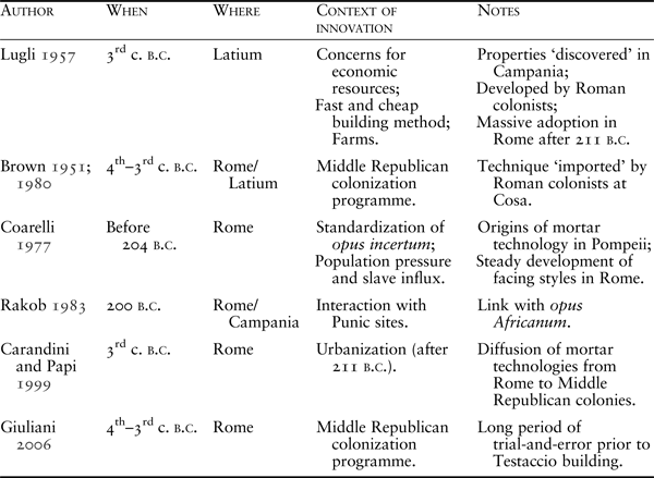
The diffusion of concrete building techniques is commonly dated to the third century b.c. or even earlier (as summarized in Table 1). This view is based largely on corpora collected before 1950, which reflect old methodologies and theoretical frameworks. A deconstruction of the argument is, therefore, in order.
Current Models of the Diffusion of Concrete in Rome and Italy

Two important developments in the period just before World War II contributed to the definition of the conventional chronology. The first was a new identification proposed by Gatti for a monument represented on the Forma Urbis Romae, for which only the last three letters of the name, i.e. -lia, were known.Footnote 8 This monument seemed to correspond in both plan and dimensions with a large concrete vaulted building preserved on the left bank of the Tiber, near the modern Testaccio. Based on the location of the archaeological remains, Gatti restored the inscription to read [Porticus Aemi]lia, a monument claimed by Livy to have been first erected in the early second century b.c. in the area of the Emporium.Footnote 9 This theory had important repercussions for the dating of concrete architecture because it provided a fixed point. Architectural historians assumed that the advanced features of the Testaccio building, especially its size (487 by 60 m) and complex vaulting (with record spans of c. 8.30 m), were the result of a long period of trial-and-error. They concluded that the introduction of Roman concrete long predated the construction date known for the Porticus Aemilia.
An important element in support of this idea seemed to come from the results of stratigraphic investigations below the floor levels of various buildings of Roman Pompeii, which Maiuri had launched in 1926.Footnote 10 These excavations revealed extensive remains of simple rubble architecture — some of it using lime — in the area of the forum, as well as in the early levels of some atrium houses. These structures were assigned to the third century b.c. or earlier, though on the basis of very limited soundings.
Lugli was the first to combine this evidence in a systematic fashion. In an attempt to classify the material from Rome and Latium, he produced a typology of concrete wall-facing styles, taking the so-called Porticus Aemilia as a reference.Footnote 11 He then linked his typology with the recent finds from Pompeii, which, together with a small sample from the deeper levels of Ostia, seemed to provide an example of the early stage of concrete architecture that would have existed in Middle Republican Rome.Footnote 12 While conceding that local builders at Pompeii could have discovered the properties of pozzolanic mortars independently, Lugli firmly believed that Latium was a likely candidate for the initial development of the technique. This idea was based on the results of extensive surveys he conducted in the 1920s in the countryside of early Roman colonies such as Tarracina and Circeii, where he documented mortar-and-rubble architecture of a type similar to that at Pompeii.Footnote 13
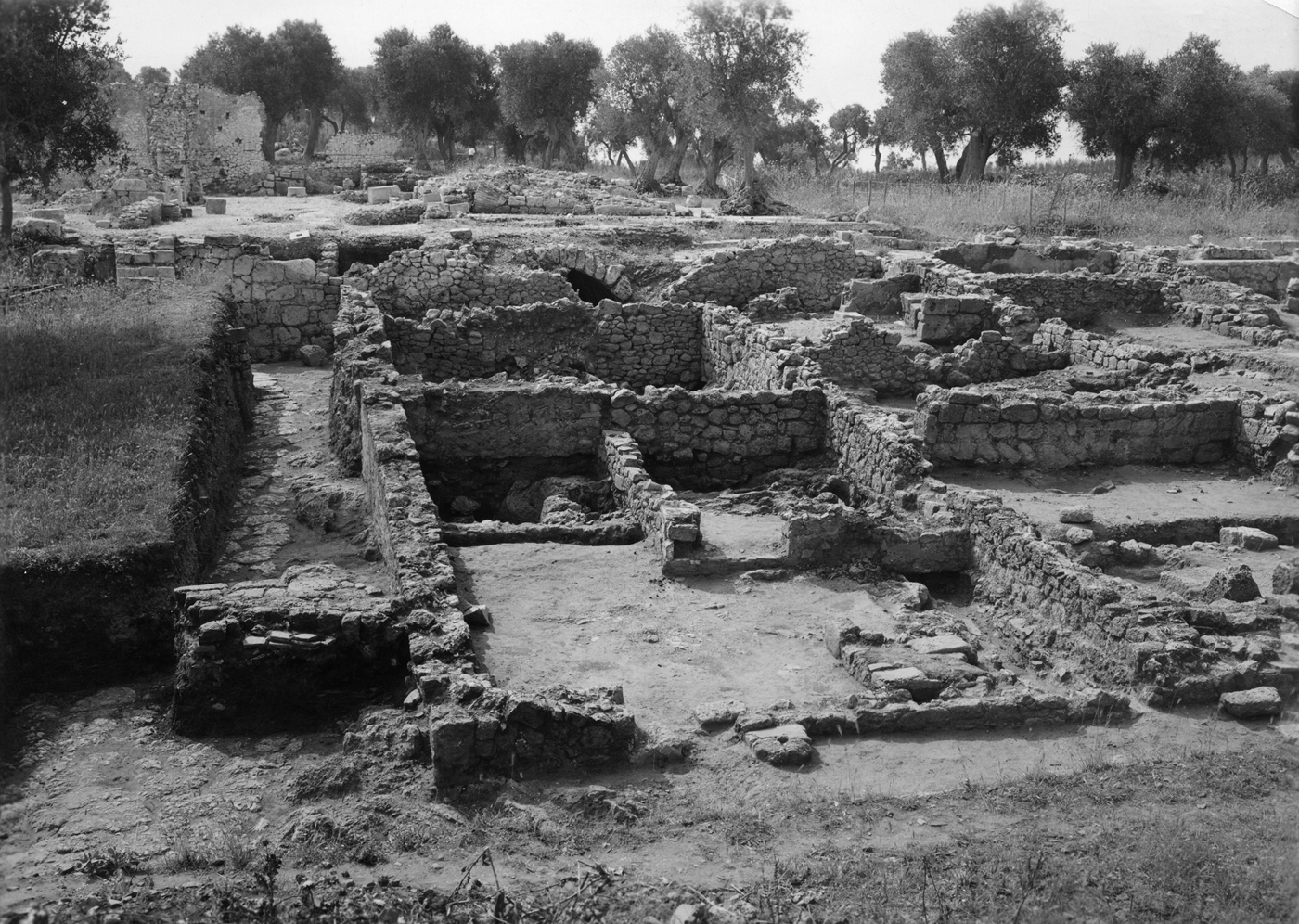
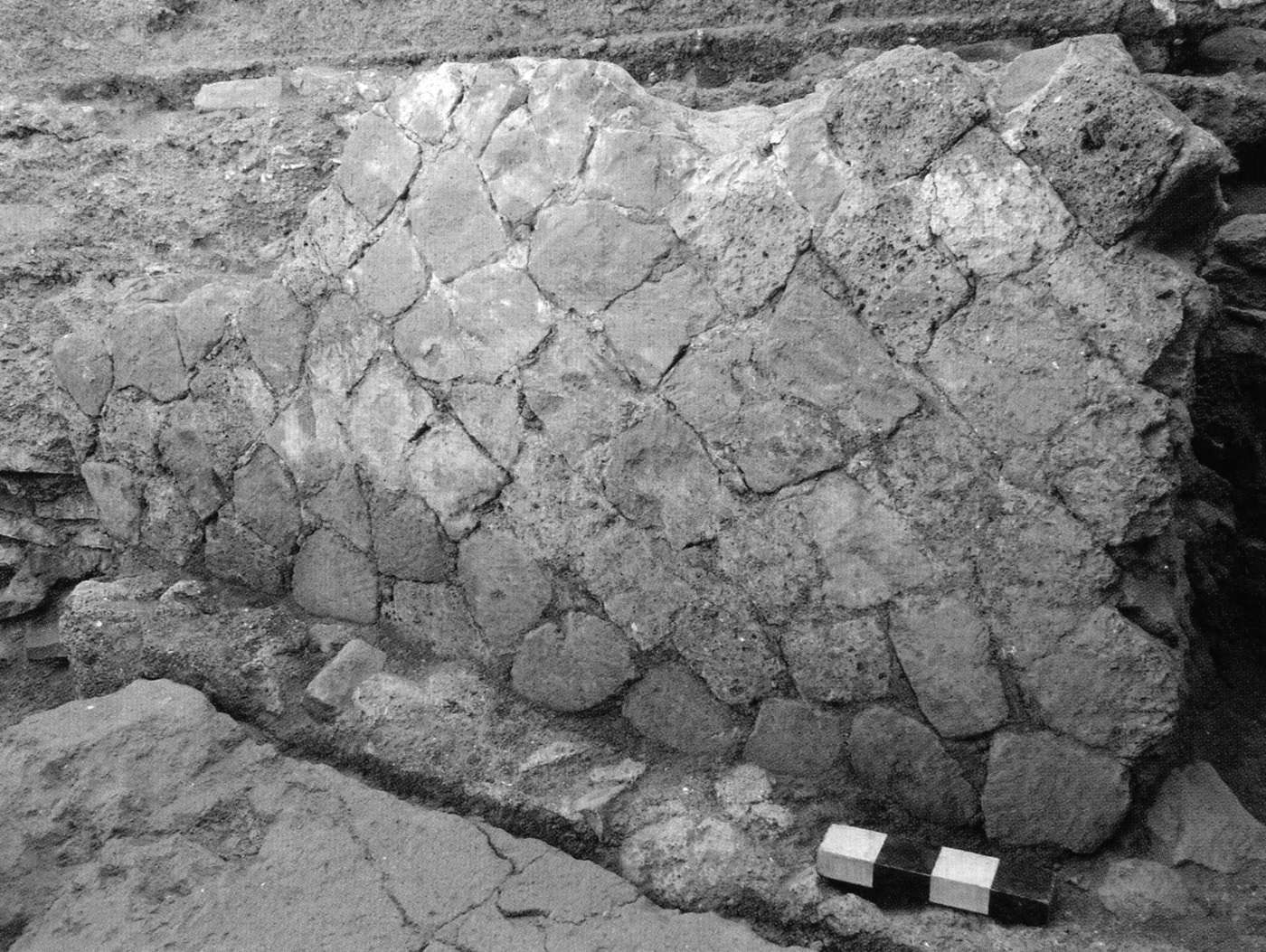
Furthermore, because these remains were predominantly associated with rural buildings, he described concrete as a cheap architectural expedient, as opposed to ashlar or polygonal masonry, contributing to the view that it was invented at the lower level of society. From his perspective, the new technology would have eventually made its way from the suburbium of Rome into the city, where decisive improvements would be achieved over a period of experimentation in the third century b.c., leading to the large-scale adoption of the building medium by the end of the century. Following the lead of Lugli, Brown assigned all the standing remains of mortared masonry he excavated around the same time at Cosa to the first building phase of the colony of 273 b.c. (Fig. 1).Footnote 14 His expectation was in fact that Cosa's colonists learned the technique at their place of origin, i.e. Latium.Footnote 15
Cosa, Basilica, Atrium Publicum. View of the north-east side and Basilica alley from the north-west, showing a sample of the mortar-and-rubble architecture uncovered by Brown at the site. (Fototeca Unione, American Academy in Rome, negative AAR.Cosa I.BA.65; © American Academy in Rome, Photographic Archive; used by permission)
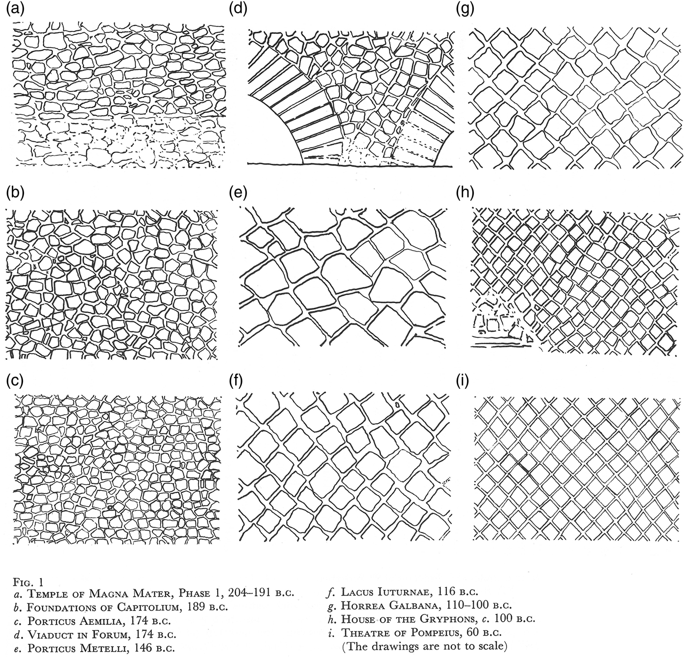
The chronology proposed by Lugli had a profound impact on subsequent scholarship. The most notable example is the influential work of Coarelli, who set out to update the typology of concrete monuments from Rome (Fig. 2).Footnote 16 Taking the wall-facing style of the so-called Porticus Aemilia as a fixed point, he tried to identify concrete public monuments that could predate the Testaccio building. In his methodology, concrete walls featuring irregularly-shaped facing-blocks and mortar joints would normally be earlier in date than walls characterized by a more regular aspect. According to this system, there would be a progressive regularization of the class of concrete walls conventionally referred to as opus incertum, culminating in the standardized opus reticulatum through an intermediate phase described as opus quasi reticulatum.Footnote 17 In Coarelli's view, this process of standardization accelerated dramatically in the third quarter of the second century b.c., and was influenced by a combination of factors: first, the economic need to provide housing for the urban plebs (Livy 21.62, mentions high-rise compounds as early as 218 b.c.); second, changes in the organization of construction linked with the availability of unskilled labour.Footnote 18 From this perspective, the gradual development of concrete techniques would still have a relationship with important implications of Roman military expansion: population growth and the influx of slavery.Footnote 19
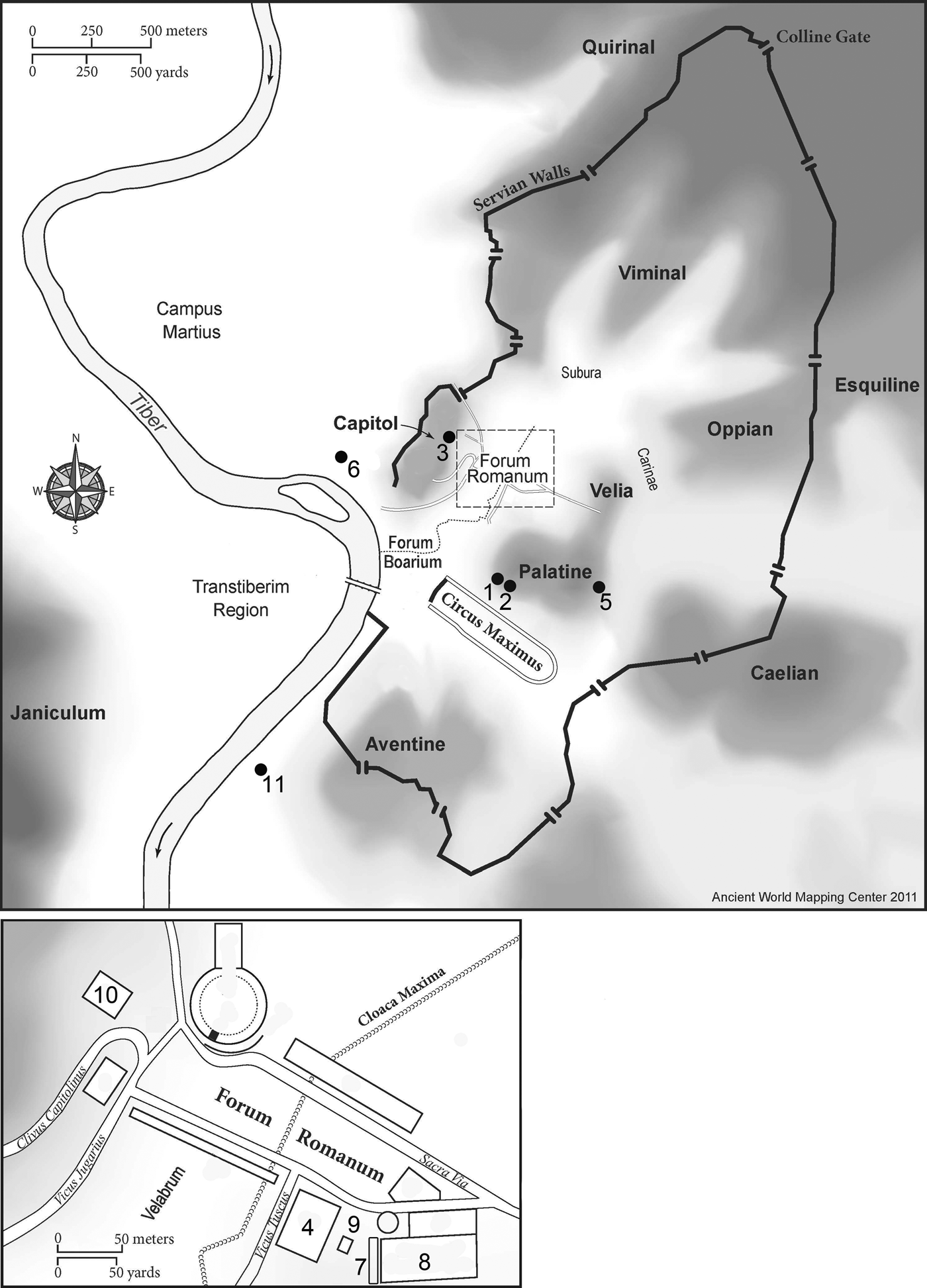
Schematic map of Rome showing the location of the public buildings discussed in Section III (1. Temple of Magna Mater; 2. Temple of Victoria; 3. Temple of Veiovis; 4. Temple of Castor and Pollux; 5. East slopes of the Palatine site; 6. Porticus Metelli; 7. Concrete ramp on the east side of the Roman Forum; 8. Aedes and Atrium Vestae; 9. Lacus Iuturnae; 10. Temple of Concord; 11. Testaccio building). (Base map: Ancient World Mapping Center © 2014 (awmc.unc.edu); used by permission)
Lugli's influence can also be seen in the scholarship of German architectural historians.Footnote 20 Rakob, for example, stressed the importance of the atrium houses of Pompeii, emphasizing the possible derivation of mortared rubble technologies from Carthage. He based this intriguing but controversial idea on similarities with walling techniques common at Punic sites in Sicily and North Africa.Footnote 21 The technological transfer was interpreted as the result of two overlapping phenomena: on the one hand, the increased interaction between Carthage and Rome in the period of the Punic wars; on the other, the intensification of contact between Rome and Campania throughout the third century b.c., from the Samnite wars onwards. Thus, the development was once again related to the political history of the Middle Republican period.
The Lugli-Coarelli scheme eventually crystallized in influential manuals on Roman construction. Giuliani supports the high date of mortar-and-rubble architecture at Cosa and other Middle Republican colonial sites, such as Alba Fucens.Footnote 22 Adam accepts the idea that in Rome concrete was routinely used for public construction projects by 200 b.c. at the latest.Footnote 23 These reconstructions identify the Middle Republican period as a decisive phase in the shaping of Roman architecture, and in various ways suggest that elements of this trickled down to the rest of the peninsula as different areas were incorporated into the Roman sphere, especially through the agency of Roman colonists.
III REDATING ROME'S CONCRETE ARCHITECTURE: THE PUBLIC BUILDINGS
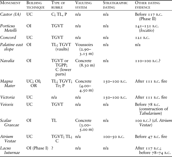
Coarelli's synopsis of purported early concrete wall-facing styles in Rome is a good place to start our discussion. That canon includes what Coarelli believed to be well-dated known monuments that would demonstrate the sequence of development of opus incertum. His conclusion was that there was a gradual progression in technique, so that walls with irregular facings would normally be earlier than structures with more regular ones, regardless of the type of building material (rubble architecture made of a harder or more intractable stone does not normally feature standardized facing blocks), its provenance (whether quarried on purpose or recycled), and the structural context of the wall (e.g. the small walling of a niche as opposed to a massive terracing wall). In the following discussion I offer a re-analysis of the canonical buildings on which the high chronology rests. The current dating of these monuments is inadequate because it is based on false ideas of the evolution of wall-facing styles. It relies mostly on conventional classifications of wall-paintings and decorated floors found within the structures, and on historical events or persons whose association with the monuments in question is often problematic. On the other hand, stratified pottery assemblages recovered from excavations carried out at some of these sites can provide a more precise guide to date the remains (see Table 2; Fig. 2).
Early Concrete Public Monuments in Rome (UC = unfaced concrete; OI = opus incertum; OR: opus reticulatum; TL = Tufo Lionato; TGPP = Tufo Giallo di Prima Porta; TGVT = Tufo Giallo della Via Tiberina; Tr = Travertine; P = Peperino; C = Cappellaccio)
The temple of Magna Mater, a multi-phased building located on the south-west corner of the Palatine, is usually cited as the earliest monument of the opus incertum sequence (Fig. 3, a). For this reason, it deserves a lengthier discussion. Coarelli's interpretation was based on evidence collected in the early 1960s by Romanelli with limited soundings in the cella.Footnote 24 These revealed that the podium consists of a concrete box made of alternating courses of varying height, which are clearly distinguishable on the basis of the prevailing types of rubble, or caementa (Tufo Giallo della Via Tiberina, Peperino and Cappellaccio; Travertine and Tufo Lionato of the varieties from Monteverde and Anio, and Tufo Rosso a Scorie Nere from Fidene).Footnote 25 Coarelli classified these walls as a rough opus incertum, and assigned them to the original construction of the temple, an event recorded by Livy (29.37.2, 36.36) for 204–191 b.c. This date would, in Coarelli's view, correspond well with the particularly unrefined aspect of the concrete masonry.Footnote 26 The large-scale excavation and mapping of the sanctuary resumed in 1978 under the direction of Pensabene, and is still ongoing.Footnote 27 A different reconstruction can be proposed on the basis of the new finds.
The sequence of development of opus incertum wall-facing styles in Rome as suggested by Coarelli. Note the alleged high dating of the temple of Magna Mater and of the so-called Porticus Aemilia, and the steady evolutionary trajectory, eventually culminating in the class of opus reticulatum. (After Coarelli Reference Coarelli1977: 11, fig. 1; © The British School at Rome; used by permission)
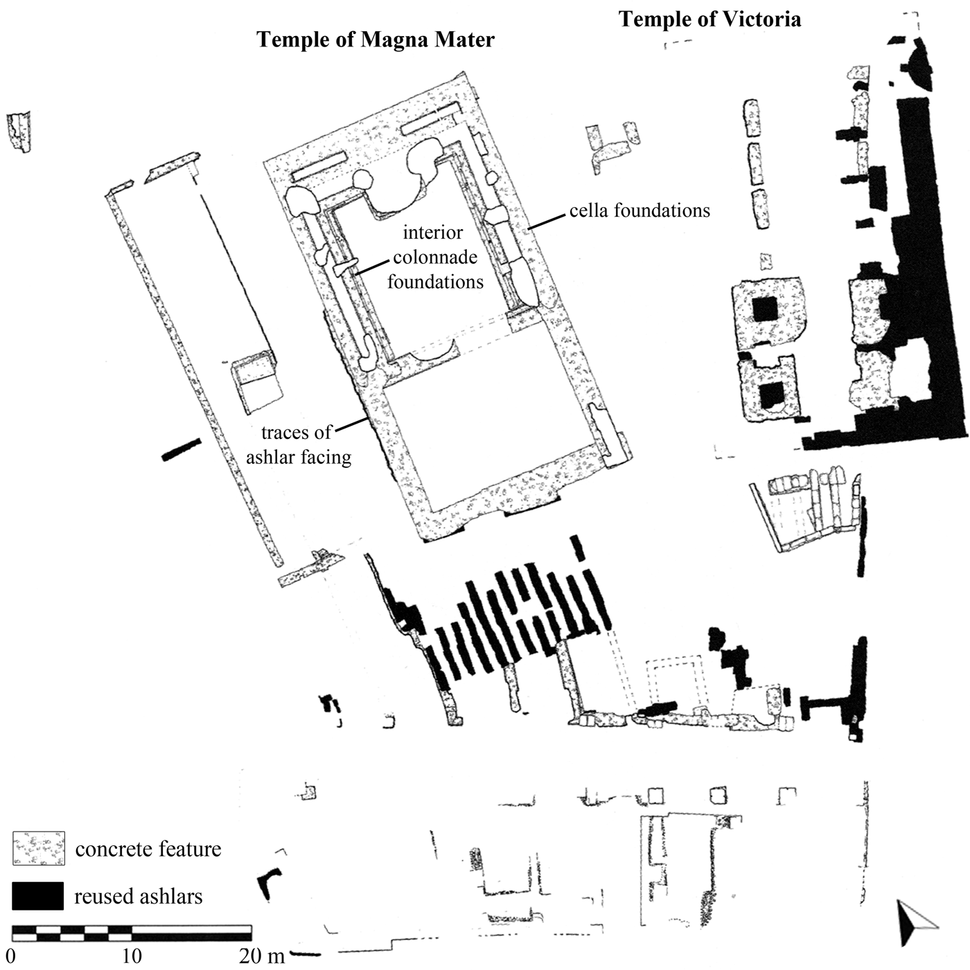
A complex series of concrete structures has been exposed to date both within the temple and in the adjacent area (Fig. 4). Pensabene's excavations on the west side of the temple revealed that the concrete podium was originally clad with ashlars, and that these were robbed in modern times.Footnote 28 Removal of the fill of the spoliation trench exposed traces of timber shuttering. The concrete structures, therefore, can be best described as unfaced because the caementa were placed by hand within the formworks without a clear distinction between core and faces.Footnote 29 In the south-west corner of the podium, however, the concrete mass appears to have been retained by a pre-existing stretch of ashlars whose imprint is clearly visible on the surface of the concrete core, consisting of five courses whose orientation is the same as that of the concrete structures.Footnote 30 At the northern end of the podium, where the robbing trench turns sharply to the west, two courses of blocks of Tufo Giallo della Via Tiberina sit perfectly on axis with the other traces. These remains should be assigned to the first phase of the temple.Footnote 31 Their alignment differs markedly from that of other ashlar structures detected in the adjacent area, which are securely dated to the Middle Republican period.Footnote 32 The raising of the concrete structure, which almost completely replaced the old ashlar podium, must, therefore, be dated to the second phase of the sanctuary, which historical texts place after 111 b.c.Footnote 33
Composite plan of the sanctuary of Magna Mater showing the architectural remains dating to the late second-century b.c. phase. (Adapted from D'Alessio Reference D'Alessio2006: table N; © Quasar; used by permission)
The substructures of the cella include a concrete wall dividing cella and pronaos, joined to the concrete box, and the foundations of the cella side-walls, abutting both the podium and the dividing wall. The foundations of the side-walls feature a rough opus reticulatum on the inner face. Parallel to the latter is another foundation built using timber shuttering on the exterior and a rough opus reticulatum facing on the interior. Its function was to support an inner colonnade. The direct stratigraphic relationship with the podium clearly indicates that all the substructures belong to the same phase, and that unfaced concrete was used side-by-side with opus reticulatum. The free-standing parts of the cella are also in rough opus reticulatum, made with caementa of Tufo Rosso a Scorie Nere, and thus are likely to be contemporary with the second phase of the podium.Footnote 34 These remains are generally connected with a redecoration of the cella documented by the surviving mosaic floor and architectural ornaments, which can be dated stylistically to the Augustan period.Footnote 35 Below the mosaic floor was a uniform construction fill extending down to the bottom of the podium foundations. This layer contained numerous inclusions of building debris, such as fragments of an earlier cocciopesto floor and Peperino architectural elements (which are also used as caementa in the concrete structures of the podium), as well as a group of Hellenistic terracotta figurines clearly in secondary deposition. This assemblage attests that temple decorations and votives associated with the first occupation of the sanctuary were disposed of in a systematic way, as part of the late second-century b.c. construction activities.
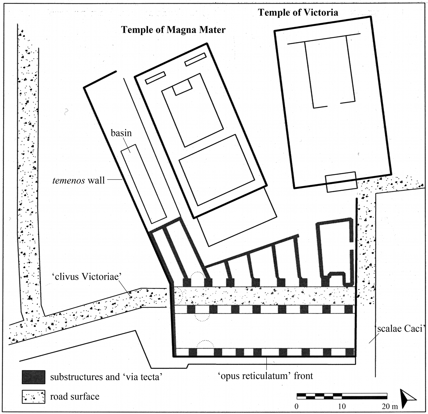
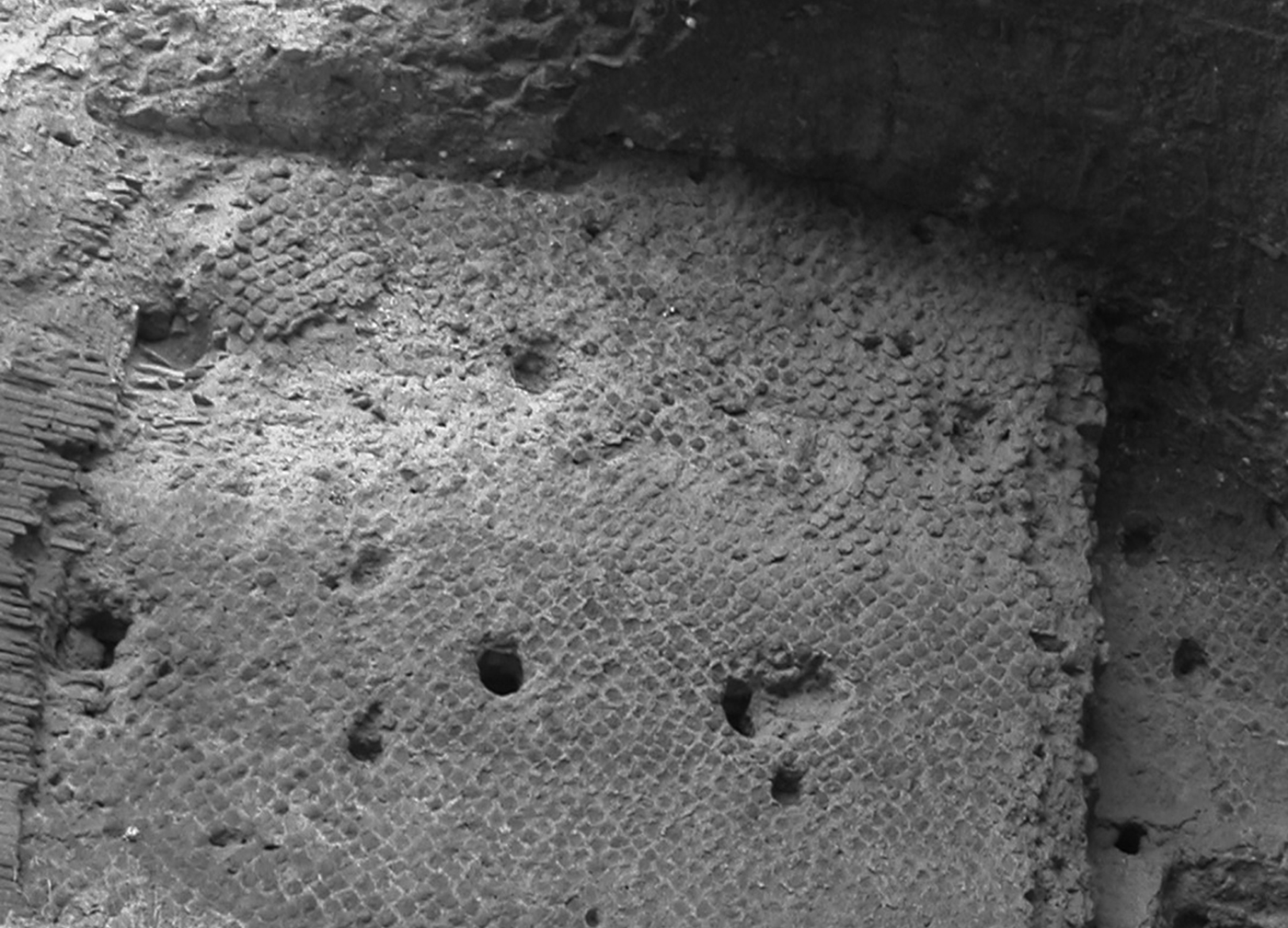
A paved terrace extending to the south slope of the Palatine was built in front of the temple at this stage (Fig. 5). This terrace is supported by a series of concrete vaulted rooms and corridors flanking a via tecta (the so-called ‘clivus Victoriae’). These structures feature ashlar piers connected by arches made of voussoirs of Tufo Lionato (Anio), and spandrels faced with opus reticulatum. Farther to the south, the platform rested on a pillared structure supported by a system of vaulted substructures in opus reticulatum of Tufo Lionato (Anio), which formed the monumental front of this side of the hill (Fig. 6).Footnote 36 Furthermore, a lower terrace delimited by a concrete temenos that includes parts in opus incertum was created west of the temple podium. An oblong basin lined with hydraulic mortar was added here.Footnote 37 The construction fills of the lower terrace contained hundreds of fragments of the same type as those found in the podium fills, providing a link between the building process of the podium and that of the platform in the reconstruction of the sanctuary post-111 b.c.Footnote 38 Thus, both opus incertum and opus reticulatum were used in this phase of the sanctuary, but for different purposes within the structure. A different crew may have worked on the opus incertum retaining wall, whose structural function was not as complex in comparison with the terrace front. The important implication, of which most modern building archaeologists are well aware, is that different wall-facing styles do not always represent successive building events, so any periodization based solely on building techniques must be taken with caution.
Restored plan of the sanctuary of Magna Mater in the late second-century b.c. phase. (Adapted from Pensabene and D'Alessio Reference Pensabene, D'Alessio, Haselberger and Humphrey2006: 41, fig. 6; © Journal of Roman Archaeology; used by permission of the author)
Construction detail of the opus reticulatum front of the sanctuary of Magna Mater. (Adapted from Pensabene and D'Alessio Reference Pensabene, D'Alessio, Haselberger and Humphrey2006: 43, fig. 10; © Journal of Roman Archaeology; used by permission of the author)
Next in the canonical sequence of early concrete architecture are two minor monuments that have been singled out on account of morphological similarities with the facing of the Testaccio building (i.e. dimension of the blocks, thickness of the mortar joints, use of small tuff ashlars to face the intrados of concrete vaults). For this reason, the low arches visible behind the Rostra in the Forum Romanum (Fig. 3, d) were linked by both Lugli and Coarelli with the first paving of the Clivus Capitolinus (Livy 41.27.7: 174 b.c.).Footnote 39 The viaduct, however, can also be compared with the substructures of the sanctuary of Magna Mater, and could just as well date to the late second century b.c. The other monument is a terracing wall on the east slopes of the Capitoline (via della Consolazione). This incorporates a stretch faced with a slightly less regular opus incertum (Fig. 3, b). Lugli's assumption was that the creation of the paved road involved a major reorganization of the Capitoline hill.Footnote 40 Coarelli argued for a higher date, identifying the remains with another feature located on the Capitoline, the substructio super Aequimelium, the construction of which was recorded by Livy for 188 b.c. (38.28.3).Footnote 41 The fact that the opus incertum structures appear juxtaposed to stretches in ashlars of Tufo Lionato (Monteverde; Anio seems absent) and Tufo Giallo della Via Tiberina (Grotta Oscura) was seen as a confirmation of the early character of the concrete facing. An alternative interpretation is possible for this stratified architectural sequence, with the opus incertum walls post-dating the opus quadratum.
The dating of the opus incertum building of Testaccio (Fig. 3, c) is even more problematic. Cozza and Tucci have recently made the case for a different identification of this monument on both epigraphic and typological grounds.Footnote 42 This is based on an alternative restoration of the inscription associated with the building represented on the Forma Urbis: [Nava]lia instead of [Aemi]lia (which, by the way, would account for the otherwise puzzling absence of the word porticus on the slab).Footnote 43 Cozza and Tucci's survey of archaeologically attested shipsheds seems to provide close comparanda for the internal organization of the Testaccio building. Footnote 44 In fact, the complex bears little in common with other known late Republican porticus.Footnote 45 With regard to the local topography, if the Testaccio building is to be identified with shipsheds attached to the Emporium, the Porticus Aemilia is more likely to be found in a location closer to the Porta Trigemina and the Forum Boarium area — the term porticus referring to a covered passageway rather than to a utilitarian building.Footnote 46
The main implication of the new identification is that the Testaccio building does not date the opus incertum; at best, the opposite is true. Cozza and Tucci, therefore, emphasized the advanced typological features of the facing, which in their view would correspond with a date in the second half or the late decades of the second century b.c.Footnote 47 Textual evidence for a secure dating of the Navalia is scanty. Cicero (De or. 1.14.62) connects an opus navale with the work of a Greek architect named Hermodorus of Salamis, presumably the same Hermodorus known to have built the first marble temple in Rome, the temple of Iuppiter Stator (Vitruvius 3.2.5).Footnote 48 The attribution remains uncertain because other Navalia are attested by ancient sources in the Campus Martius,Footnote 49 but if it were correct, a significantly lower date would have to be assigned to the monument, perhaps not earlier than 110 b.c.Footnote 50
With the so-called Porticus Aemilia out of the picture, the earliest surviving archaeological example of concrete architecture in Coarelli's canon is the Porticus Metelli. This monument was famous in antiquity because it included a number of architectural innovations (Velleius 1.11.3–4; 2.1.2; Pliny the Elder 34.31; 34.64; Vitruvius 3.2.5). It was the first porticus of the peristyle type (or quadriporticus), and its main function was to provide a formal columnar framework for the display of statues. The Imperial version of the monument was known as Porticus Octaviae.Footnote 51 This is represented on the Forma Urbis as a temenos featuring a single colonnade on the short sides to the north and south (the latter incorporates a hexastyle propylon), and a double colonnade on the long sides to the east and west. The plan of the Republican building did not differ much from that of the Augustan phase (Online Fig. 1). The earlier porticus was associated with the marble temple of Iuppiter Stator, which stood at its centre, adjacent to the pre-existing temple of Iuno Regina. This association provides a date of 143–131 b.c. for the letting of the contract.Footnote 52 The exact relationship between the foundations of the temple and the floor level of the courtyard is not known in any detail, but the erection of the temple probably started before that of the precinct surrounding the sacred area, since moving heavy building material in and out of a raised enclosure would not have been logistically feasible. Thus, a construction date in the 130s b.c. is the most likely.
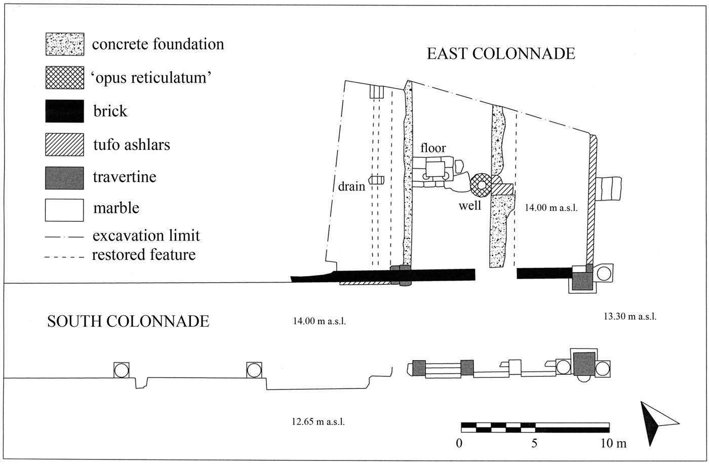
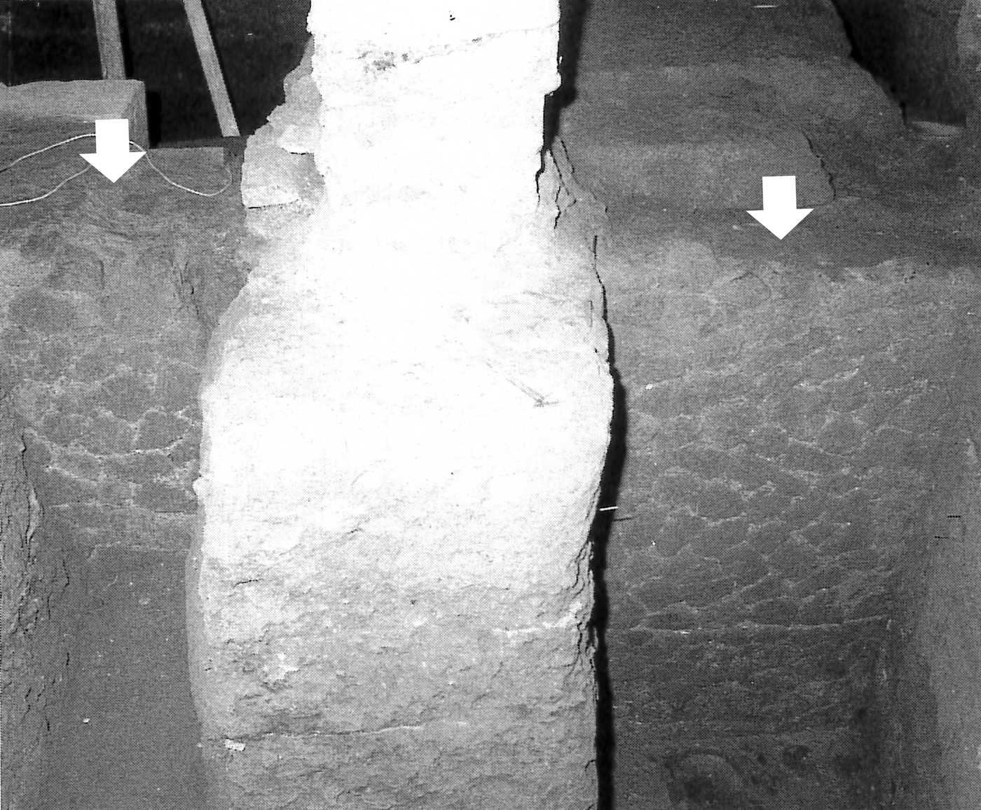
Parts of the south side were investigated first by Colini in 1950.Footnote 53 Excavations by the Soprintendenza Speciale per i Beni Archeologici di Roma were then carried out in the 1980s and 1990s in the north side, the north-west corner, and in the monumental entrance to the south.Footnote 54 The south colonnade of the quadriporticus rests on a stylobate formed by two parallel structures retaining a construction fill (Fig. 7). The external retaining wall is a thick concrete foundation with caementa of Tufo Giallo della Via Tiberina faced with stretchers of Tufo Lionato (Monteverde) ashlars (the top course of Peperino headers belongs to the Augustan reconstruction).Footnote 55 The internal retaining wall is of opus incertum made with facing blocks of Tufo Lionato (Monteverde).Footnote 56 The projecting propylon at the centre of the south side seems to have been added only in the Imperial period: the external retaining wall continues behind it, and is flanked to the south by a drain.Footnote 57 The original entrance was probably marked by columns of bigger module incorporated in the exterior colonnade.Footnote 58 Interruptions in the ashlar facing indicate the presence of other staircases.Footnote 59 Both the south-east and the north-west corners of the porticus feature two parallel concrete foundations built with the same technique (Figs 7–8). These structures confirm the presence of a double colonnade on the long sides.Footnote 60
Plan of the south-east corner of the Porticus Metelli. (Lauter Reference Lauter1980–81: 40, fig. 1; © L'Erma di Bretschneider; used by permission)
North-west corner of the Porticus Metelli. The white arrows indicate the opus incertum foundation of the stylobate. (Giustini Reference Giustini1990: 73, fig. 17; © Istituto Poligrafico e Zecca dello Stato; used by permission)
In sum, the system employed to raise up the quadriporticus is clearly that of the concrete box lined with opus quadratum, which has been described for the temple of Magna Mater. The continued development of this building type is attested throughout the last third of the second century b.c., particularly for temple podia. Well-known examples are the temple of Veiovis (third quarter of the second century b.c.),Footnote 61 the temple at S. Salvatore in Campo (post-132 b.c.),Footnote 62 the temple of Concord (121 b.c.),Footnote 63 and the temple of Castor and Pollux (post-117 b.c.).Footnote 64
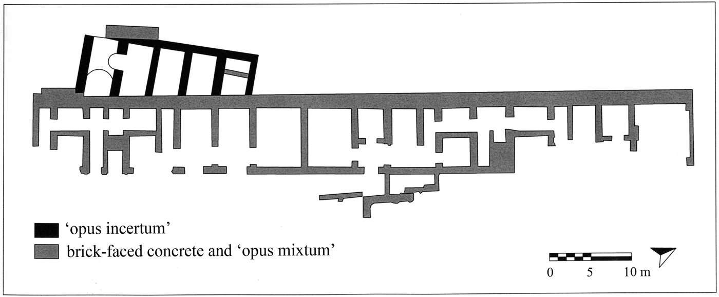
The last few decades of archaeological research have failed to produce conclusive evidence of earlier concrete-based public architecture in the monumental core of Rome. A series of concrete vaulted structures are located on the east slopes of the Palatine (between the sites of Vigna Barberini and the Domus Flavia; Fig. 9). The barrel vaults feature an intrados faced with medium-sized oblong rectangular blocks of Tufo Giallo della Via Tiberina laid radially. The walls are made with opus incertum of quite regularized facing blocks of Tufo Lionato (Anio) of various sizes, recalling the technique of the Testaccio building and of other contexts in Latium that can be generically dated to the second half of the second century (Praeneste, Via degli Arcioni; lower terrace of the Forum of Cora) or early first century b.c. (the extra-urban sanctuary at Tusculum).Footnote 65 The monument has been interpreted as a temple platform, though no traces of the supposed temple building are associated with it. Anselmino has proposed a date as early as 150 b.c. for the complex, assuming that a group of terracotta sculptures found in secondary deposition farther downslope during old excavations formed part of its original decoration.Footnote 66
Schematic plan of the opus incertum substructures located on the north-east slopes of the Palatine. (Adapted from Anselmino Reference Anselmino2006: 231, fig. 8; © Quasar; used by permission)
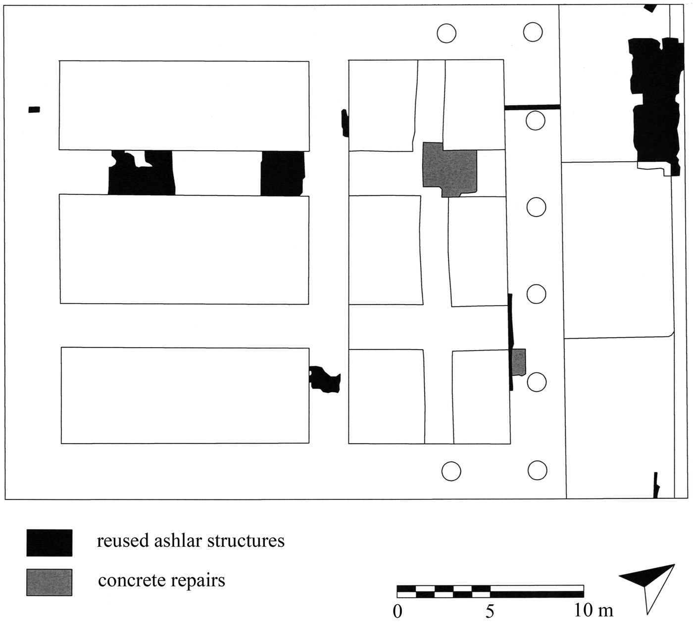
A possibly safer case can be made for some small-scale concrete features in the temple of Castor and Pollux. Concrete fills were poured for minor repairs of the ashlar foundations of the front part of the podium (Fig. 10). This had been radically modified in the middle of the second century b.c., dismantling several courses in order to accommodate a lower step in the platform (perhaps a tribunal),Footnote 67 most likely causing structural damage over time. More of the old Cappellaccio blocks were thus removed at a later stage, only to be recycled as rubble in the concrete cores. Steinby has proposed to contextualize these modifications within a broader building programme affecting the east side of the Forum Romanum (Online Fig. 2). This programme would have included, in rough chronological order, the creation of a ramp along the western boundary of the sanctuary of Vesta, the monumentalization of the Lacus Iuturnae, the recasting of the temple of Castor and Pollux, and the erection of a stoa, portico or basilica incorporating the Lacus, a series of works which in her view should be attributed to the censorship of L. Aemilius Paullus (164 b.c.).Footnote 68
Restored plan of Phase IA of the temple of Castor and Pollux, with indication of the actual remains. (Adapted after Nielsen and Poulsen Reference Nielsen and Poulsen1992b: 83, fig. 61; © De Luca; used by permission)
Steinby's identification and dating of these monuments is mostly based on textual evidence.Footnote 69 Following Coarelli's chronology, she takes the occurrence of opus incertum in both the ramp and the basin as confirmation of a date in the early second century b.c.Footnote 70 The ramp, supported by a row of parallel rooms covered with barrel vaults, was built to span the drop in elevation from the Via Sacra to the Via Nova. The function of this ramp, commonly referred to as the scalae Graecae or scalae Anulariae, was to serve as a public route to reach the site of the Porta Romanula on the north-western corner of the Palatine without having to pass through the Forum.Footnote 71 The structure, which can be compared with the viaduct of the Clivus Capitolinus on the opposite side of the Forum, formed an integral part of the Atrium Vestae. Most likely, therefore, it was built in connection with the first phase of the latter complex in which there was a widespread use of concrete. Recent stratigraphic excavations in the sanctuary of Vesta date this phase to around 100 b.c.Footnote 72
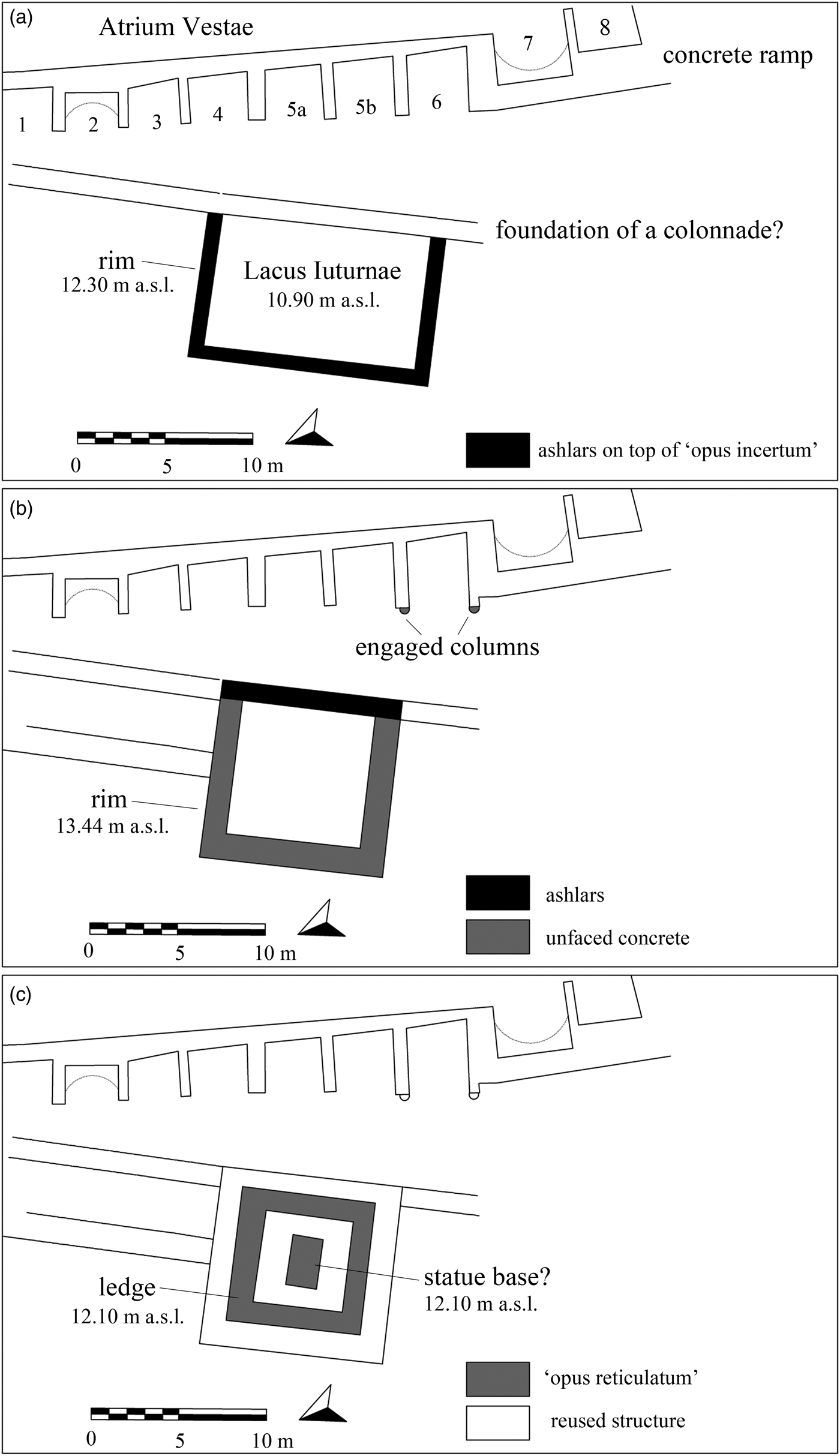
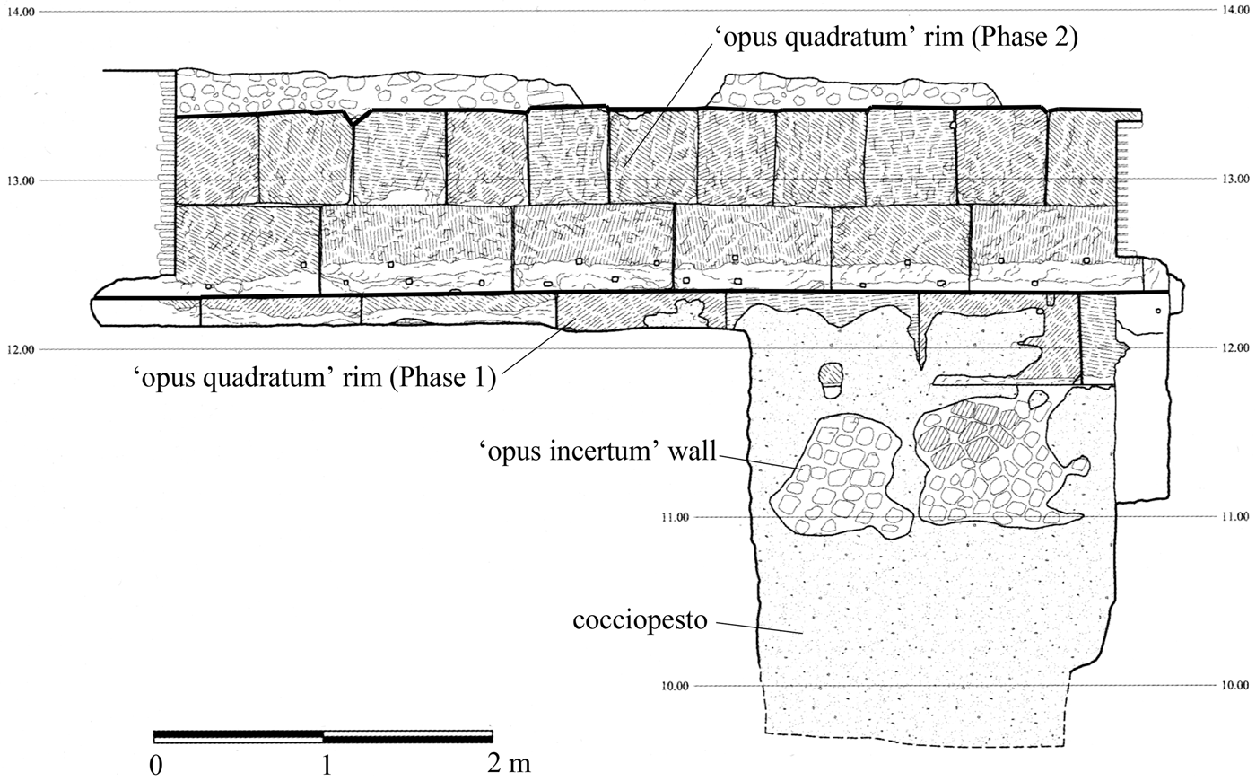
Three concrete phases have been identified in the Lacus Iuturnae on the basis of facing styles and stratigraphic relations (Fig. 11). The earliest structures consist of opus incertum and opus quadratum (Fig. 11, a; Fig. 12). The second phase features unfaced concrete and opus quadratum (Fig. 11, b; Fig. 12). The third phase is represented by opus reticulatum modifications (Fig. 11, c). The absolute dating is uncertain but the level of Phase 2 can be linked with a generalized reorganization of the Forum pavement, a building episode that has been dated to 78–74 b.c.Footnote 73 The new pavement required a raising of the basin rim, so a terminus ante quem for the opus incertum phase of the fountain can be established. The original construction of the Lacus Iuturnae could just as well be connected with other activities involving the temple of Castor and Pollux in the post-117 b.c. period.Footnote 74
Simplified map showing the relationship between the concrete ramp and the three main phases of the Lacus Iuturnae (a: end of second century b.c.; b: mid-first century b.c.; c: Augustan period?). Plan and room numbers based on Steinby Reference Steinby1985: 79, fig. 2.
Elevation drawing of the east side of the Lacus Iuturnae basin showing the superimposed remains of Phases 1 and 2. (Steinby Reference Steinby2012b: 52, fig. 16; © Quasar; used by permission)
Two roughly parallel concrete foundations of considerable thickness run north of the basin, truncating part of the wall delimiting the concrete ramp to the north (Online Fig. 3, structures a and b). Remains of a floor preserved at approximately the same level as the Sullan pavement of the Forum are associated with these structures.Footnote 75 A third foundation with square buttresses (Online Fig. 3, structure c), not perfectly aligned and perhaps later than the other two, was found razed in test-trenches excavated along the eastern side of the temple of Castor and Pollux.Footnote 76 The identification of these structures, which overall seem to post-date the original Lacus, remains problematic.Footnote 77
IV REDATING ROME'S CONCRETE ARCHITECTURE: THE HOUSES
What is also emerging very clearly with the progress of stratigraphic investigations in the deeper levels of Rome is that the Middle Republican period witnessed limited developments in élite domestic architecture. An intensive phase of house construction has been documented for the sixth century b.c, when new types of aristocratic residences with expensive architecture surfaced both in the urban core and in the suburbium.Footnote 78 These buildings were carefully maintained for centuries with little structural modification other than the periodic reconstruction of floor levels in the fourth and third century b.c.Footnote 79 Another peak of activity is attested in the first century b.c. There is a great deal of information about the urban development of the Palatine hill. A series of literary accounts vividly portrays the phenomenon of élite competition for real estate property in this area of the city throughout the Late Republican period.Footnote 80 At least twenty-three domestic contexts are known archaeologically, all featuring a phase in opus reticulatum dating to the early or middle part of that century.Footnote 81 Both here and in other areas of Rome, however, the record for the second century b.c. is much less consistent.Footnote 82
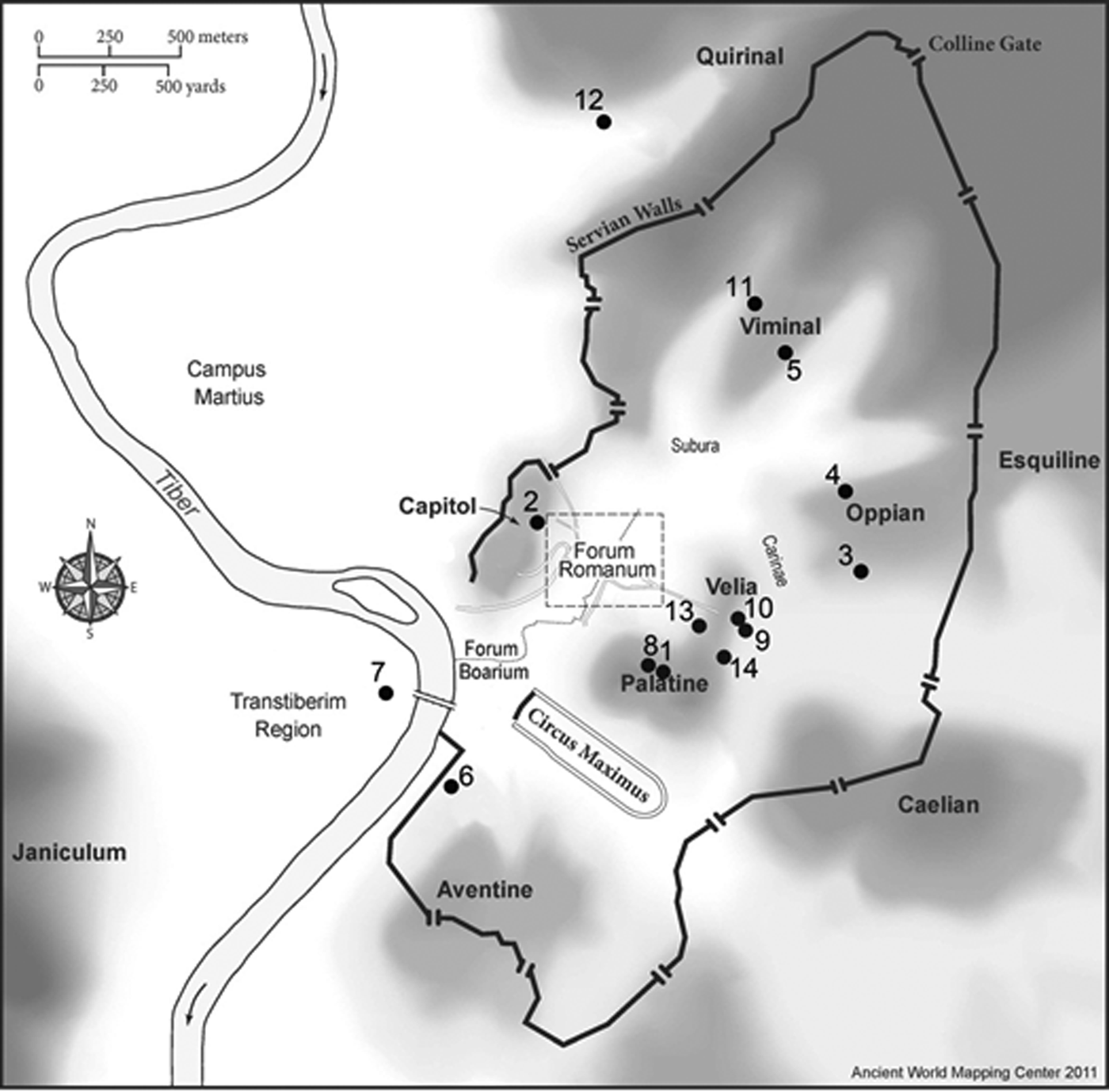
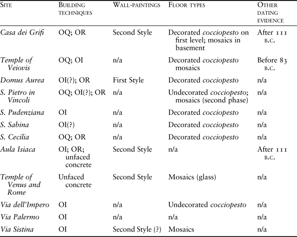
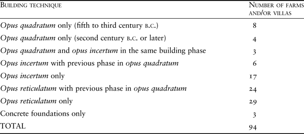
Opus incertum architecture has been securely identified only at a handful of sites (Fig. 13; Table 3), whose dating is difficult due to the lack of contextual finds.Footnote 83 As already mentioned, a deeply rooted opinion is that the implementation of Roman concrete originated from a slow process of trial-and-error, of which only the later phases of development would be archaeologically visible.Footnote 84 This common view is based on the assumption that no trace of early mortars could possibly be preserved in the archaeological record of Rome because of the weak properties possessed by the binding materials allegedly used during the experimentation phase (whether clay, simple lime or mixes of lime and sand). The body of Archaic architecture made of perishable materials that is emerging from the early layers of Rome is more than enough to undermine this idea. The scarcity of opus incertum structures has also led some to believe that there was a distaste for the unrefined aspect of this masonry style, whose origins were thought to lie in the rural context, and that the development of opus reticulatum, which is typically described as more aesthetically pleasing, determined radical reconstructions of earlier concrete buildings.Footnote 85 The problem, of course, is that the unrefined character of the masonry would have been masked by the thick layer of plaster that usually covered the walls. If we look to the much larger sample of aristocratic residences from the suburbium, we see that opus quadratum remained the predominant building technique well into the second century b.c. (Online Fig. 4; Table 4).Footnote 86 Medium-sized farms of the Middle Republican period typically show substantial renovation phases only in the middle to late first century b.c., with extensive additions in opus reticulatum transforming their plans quite radically. Larger rural residences, which were often created in the Early Republican period, feature only minor additions, whether in opus incertum or opus reticulatum. Evidence of clay-based or simple lime-based mortared rubble is virtually absent, even in small farms. When continuity of occupation through the Late Republican period is attested, concrete structures make a significant appearance only in the first century b.c.Footnote 87
Schematic map of Rome showing the location of Late Republican concrete houses (1. Casa dei Grifi; 2. Temple of Veiovis site; 3. Domus Aurea site; 4. S. Pietro in Vincoli; 5. S. Pudenziana; 6. S. Sabina; 7. S. Cecilia; 8. Aula Isiaca; 9. Temple of Venus and Rome site; 10. Via dell'Impero; 11. Via Palermo; 12. Via Sistina; 13. North slopes of the Palatine; 14. North-east slopes of the Palatine). (Base map: Ancient World Mapping Center © 2014 (awmc.unc.edu); used by permission)
Late Second and Early First Century b.c. Domestic Concrete Architecture in Rome (OQ = opus quadratum; OI = opus incertum; OR = opus reticulatum)
Distribution of Building Techniques in Rural Sites of the Suburbium of Rome (Fifth to First Century b.c.)
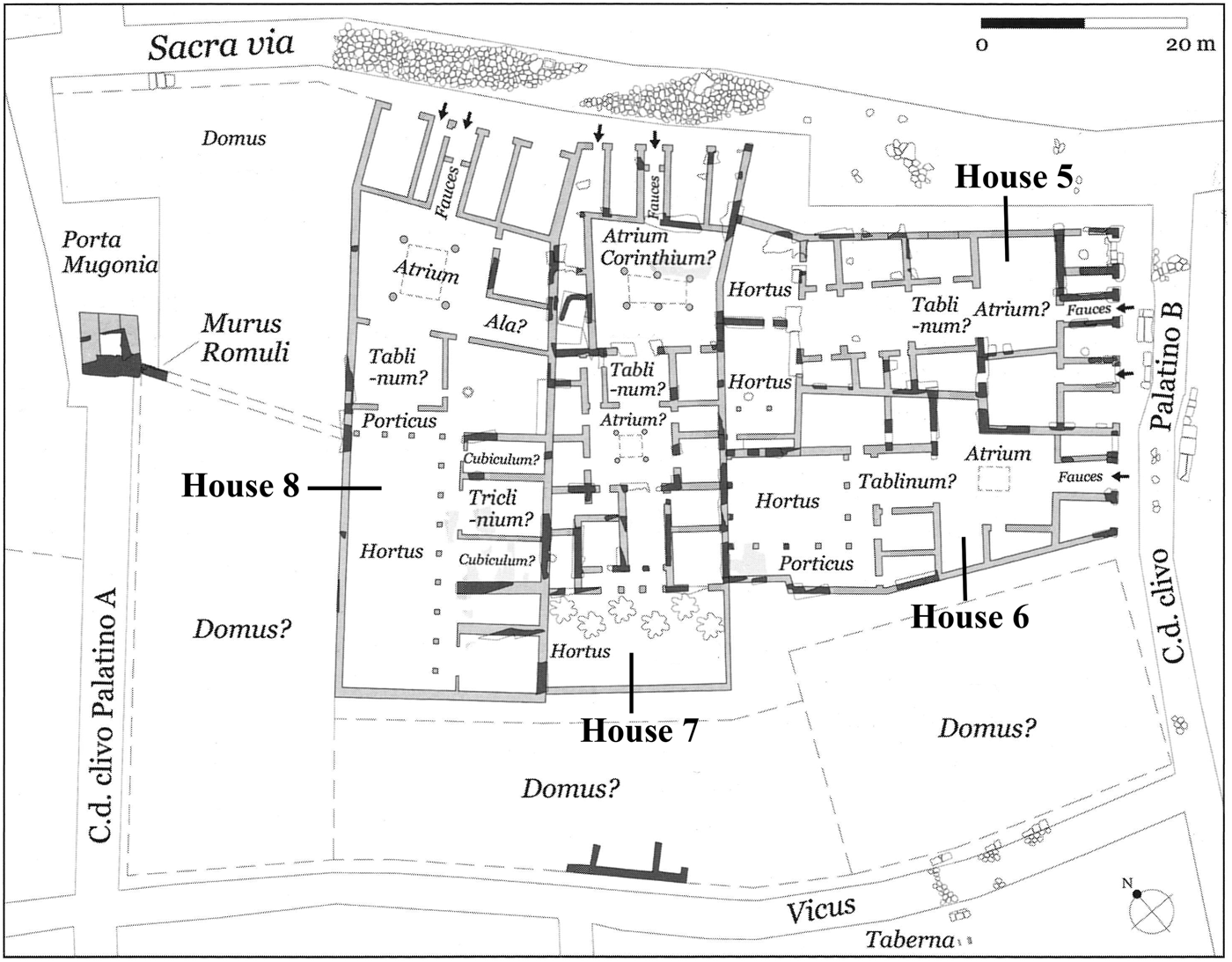
While in many ways confirming the extent and impact of similar architectural developments in élite urban housing of the first century b.c., the recently published results of a large-scale research project carried out between 1985 and 1990 by Carandini and his team on the north slopes of the Palatine provide a detailed picture of building practice in the preceding period.Footnote 88 Stratigraphic excavations were conducted in the block delimited by the Via Sacra to the north, the so-called Clivus Palatinus to the east, and an east–west road leading from the Clivus Palatinus to the so-called Scalae Graecae (by some identified with the Nova Via mentioned in historical texts).Footnote 89 This insula (Fig. 14) contains a series of concrete foundations associated with opus incertum and opus quadratum walls built on top of decapitated opus quadratum remains dating to the Archaic, Early and Middle Republican periods.Footnote 90Opus reticulatum structures are also attested, documenting the redevelopment of the block in the first century b.c. Although late features hamper the overall legibility of its internal organization, the excavators identified four houses with access from the Via Sacra and the Clivus Palatinus (labelled Houses 5–8). The best preserved case for a plan can be made for House 7, a complex that can confidently be said to have had two atria separated by an axial tablinum. The internal organization centred on two atria, with the bigger one being without a cistern, finds a comparison in late second-century b.c. examples such as the Casa del Criptoportico at Vulci.Footnote 91
Map of the city-block excavated by A. Carandini on the north slope of the Palatine, showing the hypothesized property divisions. The actual remains are indicated with solid line. (Adapted from Carandini et al. Reference Carandini, Bruno and Fraioli2010: 102, fig. 43; drawing by Daniela Bruno; used by permission of the author)
The construction process started with the systematic demolition of the Archaic houses. These were razed to a uniform level across the new block; a sequence of construction fills was dumped to regularize the undulating topography. Trenches up to a few metres deep were then dug through these deposits for the concrete foundations, with no evidence of shuttering being used.Footnote 92 When new foundations for load-bearing structures had to be built on the same alignment as previous walls, the latter were usually demolished down to a deeper level, suggesting that the use of concrete was deemed structurally superior. Provenance of the caementa indicates that the rubble was most likely obtained from the destruction of the Archaic structures (these were in fact built with ashlars of Cappellaccio; Tufo Giallo della Via Tiberina had been employed in fourth century b.c. restorations).Footnote 93 When Cappellaccio aggregates are predominant, it is always in combination with a mortar of poorer quality, which, however, normally contains pozzolana. On the other hand, Tufo Giallo della Via Tiberina caementa occurs in greater quantity with mortars of improved composition. Likewise, aggregates of Tufo Lionato, a material which was extensively exploited for cut-stone construction of the Republican period, are far less frequent. They increase noticeably when used in combination with a type of mortar of better quality that occurs only in foundations located along the irregular boundary between Houses 5 and 6, as well as in structures that can be more securely assigned to the first century b.c. (these foundations, therefore, could represent later modifications). Similarly in House 8, the boundary walls have foundations built with the Cappellaccio-based concrete, but the series of small rooms adjacent to the eastern limit feature the better type of mortar, suggesting that there were changes in the internal organization of the house at a later stage.
Opus quadratum was extensively used in combination with the concrete foundations for exterior façades and internal walls. In House 8, the walls of the tabernae on the Via Sacra, the west boundary wall, and at least one of the internal subdivisions have free-standing parts in Tufo Lionato ashlars. Both Tufo Lionato and Cappellaccio blocks were used for load-bearing walls in House 6 (on the west and south-west sides), while earlier Cappellaccio walls were maintained for internal subdivision in the front and back of the house. The party-wall separating House 5 from House 6 is made of Tufo Giallo della Via Tiberina ashlars, further suggesting that this part of the house was built in quite a different fashion, perhaps at a later stage. In House 7, ashlars were used for internal subdivision on the north-western side of the larger court, and negative impressions of blocks have been detected on the top surface of the foundation that separates the central part of the house from the tabernae. The evidence, therefore, suggests that there was a selective use of concrete. The new building medium seems to have been developed in order to provide a rapid and economical way of building solid foundations for the new houses, making extensive use of recycled building materials, as can also be observed in the case of the temple podia discussed in the previous section. Its use for free-standing walls is poorly documented, due to the levelling of the city-block in the subsequent phase, but some of the foundations may have supported concrete walls.
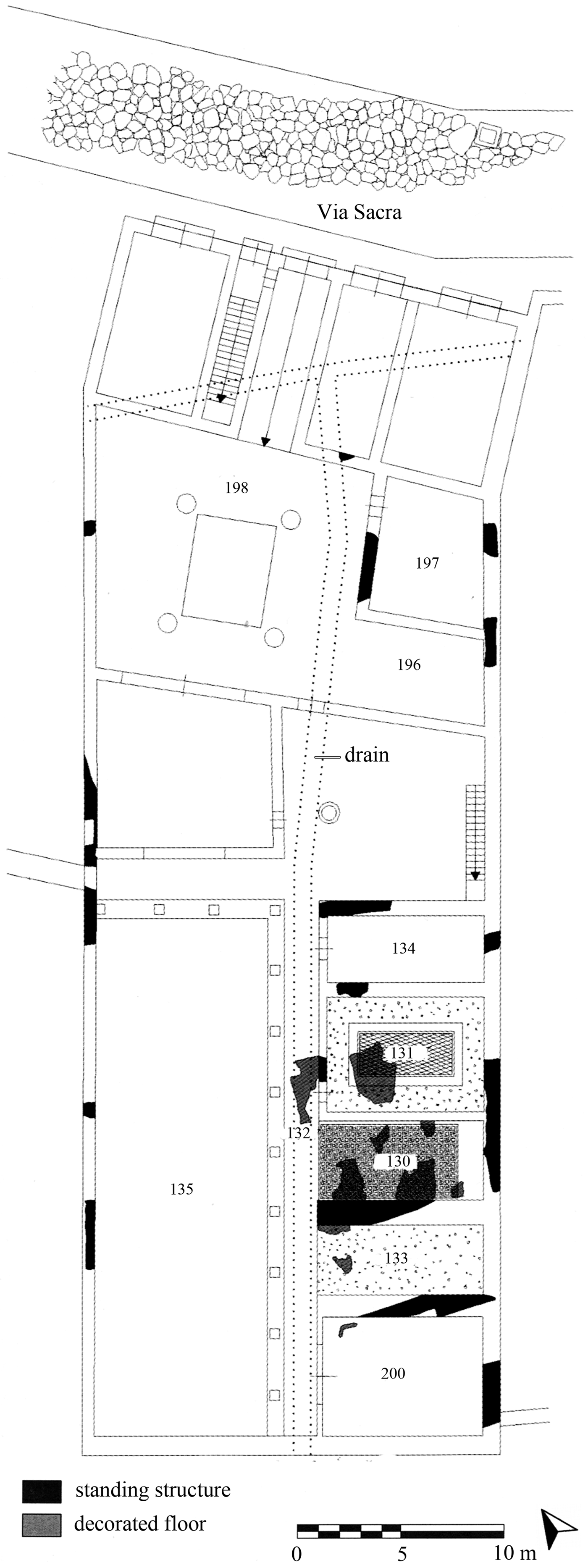
The dating of these concrete structures is difficult. Unfortunately, the construction of semi-subterranean quarters in the middle of the first century b.c. caused the almost complete destruction of the stratigraphy that was originally associated with the early concrete buildings.Footnote 94 Floor levels are preserved only in one of the houses, House 8 (Fig. 15), which seems to come later in the sequence of occupation of the block. This building features decorated cocciopesto floors of a type that is attested in the second phase of the houses of Fregellae (185–150 b.c.), as well as in other domestic contexts in Rome dated stylistically to the end of the second century b.c.Footnote 95 The floor of Room 130 is associated with what may have been a wall-painting in the First Style, the remains of which are very limited. The introduction of this decorative system in Latium has been dated to the second quarter of the second century b.c., though its diffusion peaks in the last quarter of that century.Footnote 96 A small assemblage of (early?) second-century b.c. pottery has been recovered from a construction fill in House 7,Footnote 97 but deposits of this kind normally contain frequent residues, and at best provide a terminus post quem. A terminus ad quem has been derived from the possible identification of one of the houses in this block with a known building, the domus of Cn. Octavius, which Cicero (De off. 1.138) places on the Palatine and connects with Octavius' election to the consulship in 165 b.c.Footnote 98 The link between the excavated remains and literary accounts, however, should be taken with caution. The archaeological evidence from this site seems to be consistent with a date between the second and last quarters of the second century b.c.
Restored plan of House 8 with room numbers and indication of actual remains. (Carandini and Papi Reference Carandini and Papi1999: 44, fig. 28; © Istituto Poligrafico e Zecca dello Stato; used by permission)
A more precise and reliable date can be assigned to another group of aristocratic houses, which C. Panella and her team have been investigating just one block away from Carandini's dig, on the north-east slopes of the Palatine and the south-east slopes of the Velia, in the area of the Meta Sudans.Footnote 99 These buildings, of which only the front parts are known in any detail, feature deep concrete foundations, which support ashlar façades and opus incertum party-walls (e.g. in the house identified on the north-east slope of the Palatine: Fig. 16).Footnote 100 The pottery assemblage recovered from the levels associated with the houses and related infrastructure date the construction to the middle of the second century b.c.Footnote 101 As on the north slopes of the Palatine site, the concrete is composed of mortar made with lime and pozzolana (thus, the mortar is of the hydraulic type), and the aggregates are mostly of Cappellaccio. The caementa were obtained from the demolition of the Archaic structures that occupied the same area in the previous period, which only showed minor modifications in the Middle Republican period.
Construction detail of the Late Republican house excavated by Panella on the north-east slopes of the Palatine, showing an opus incertum party-wall on top of a concrete foundation. (Carbonara Reference Carbonara2006: 18, fig. 3; © Quasar; used by permission)
The many similarities in the architectural sequence attested at both sites strongly suggest that these early examples of concrete architecture belong to the same building phase. The reconstruction of the houses probably followed the overall reconfiguration of the urban infrastructure in the central sector of the city, which involved first the laying-out and paving of new road surfaces and the redefinition of the city blocks (Livy 41.27.5 informs us that this undoubtedly lengthy project was started by the censors of 174 b.c.).
V THE SOCIAL CONTEXT OF THE TECHNOLOGICAL INNOVATION
While many contradictions characterize the traditional chronology of public buildings, which depends on questionable associations between archaeological remains and historical characters or episodes mentioned in ancient texts, the survey of excavated urban sites for which stratigraphic data are available allows us to lay some firmer groundwork. Thanks to the new material, élite house construction can be brought into the picture, complementing previous reconstructions based mainly on public architecture. The private building industry emerges as a context in which important steps toward the development of concrete may have been achieved. Starting around the middle of the second century b.c., long-lived aristocratic compounds that had stood unaltered for centuries were torn down and rebuilt, particularly in the areas closer to the monumental and political core. The theme of private expenditure in the domestic architecture of that period in Rome is in fact well-known from literary accounts, which also seem to establish a link between the consumption of luxury building materials and self-aggrandizement, ultimately connecting architectural developments with the semi-public function of the Roman house and increasing political competition for public office.Footnote 102 Interestingly, Torelli and Marcattili suggest that the spread of First Style wall-decorations in élite houses of this period may have primarily had the function of visually recreating, within the domestic space, the ashlar masonry environment of political buildings such as the basilicas and quadriporticus. They also point out how the isodomic stuccoes alluded to the marble environment of Classical Greece, and that this would be another instance of the neoatticism that characterized contemporary arts.Footnote 103 They connect this trend with the cultural impact of the conquest of the Greek East — and in particular of the Greek mainland — which eventually determined the demise of old Middle Republican values and canons. The development of concrete architecture in the domestic sphere can be contextualized as part of this process, and the important conclusion seems to be that the display of new architectural styles (also in terms of house plan and design) suddenly became more important than emphasizing the continuity of occupation of centuries-old homes. Far from originating at the lower level of society in the Middle Republic, as previously assumed, the origins of the new building medium have a relationship with Late Republican élite fashions.
The earliest public monument for which a construction phase in concrete can be pinpointed with a certain precision is the Porticus Metelli, whose date is within a couple of decades of that of the earliest datable houses. However, precisely because we have so little information about Rome's public buildings, to conclude that the use of the technique was initially limited to the private context would risk being an argument ex silentio.Footnote 104 A stark contrast can in fact be observed in the city-block occupying the north slope of the Palatine, south of the Via Sacra, where the group of public buildings adjoining the aristocratic houses (so-called Domus Publica; Atrium Vestae) received concrete additions only in the course of the first century b.c. The reason for this, however, may have to do with the need for preserving the ancestral character of these public monuments. On the other hand, attempts at using the new building medium for repairs of foundations are attested, although on a smaller scale, in the temple of Castor and Pollux (Phase IA), which may be contemporary with the houses. As we have seen, the widespread diffusion of the new building medium can be observed in the last quarter of the second century b.c., particularly in connection with the rebuilding of temple podia on existing sites (thus mirroring the construction process described for the houses), as documented by the temples of Veiovis, Concord, Castor and Pollux, Magna Mater and Victoria. The latter two monuments are associated with the earliest datable examples of free-standing concrete walls and concrete vaults (i.e., the via tecta and the monumental front of the south-west corner of the Palatine, c. 110–100 b.c.). However, free-standing opus incertum architecture is attested from the beginnings of concrete construction in both Latium, at sites such as Tibur (particularly in aristocratic residences in the countryside, for which a date within the first half of the second century b.c. has recently been suggested),Footnote 105 and Campania, at sites such as Pompeii (e.g. the Casa del Fauno, which dates to 175–150 b.c., and the slightly later Casa di Pansa)Footnote 106 and Puteoli (Rione Terra).Footnote 107 The apparent gap in Rome may be due to the state of the evidence, suffering from the radical transformation of the monumental core in the Imperial period, and to the poor dating of terracing structures (particularly those on the east slope of the Palatine, which may be as early as 150 b.c.).
The pattern just described confirms that there was a close link in architectural practice between the public and private contexts. The fact that the few names of architects known for the Late Republican period are clearly connected with high ranking families, like the Mucii and the Cornelii, is in itself a strong indication that architectural developments in the public and private spheres had a common root at the élite level.Footnote 108 Furthermore, this idea fits well with what we know about the organization of public construction in Republican Rome.Footnote 109 Public building was sponsored by the same aristocratic patrons who commissioned the refashioning of the old élite residences in the urban core. An example may be Cn. Octavius, the possible owner of one of the concrete houses on the north slope of the Palatine, who also built a porticus, perhaps of the same general kind as that of Metellus (which we know incorporated concrete foundations).Footnote 110 In theory, he could have used the same professional builders for both projects. By the middle of the second century b.c., public works were normally contracted out to private builders, but the system is certainly earlier.Footnote 111 The legal framework, therefore, originated in a period in which ashlar architectural traditions were dominant. Innovating in this field implied a great deal of social and political risk for the public official who let the contract.Footnote 112 This explains why the widespread adoption of concrete in public construction went in parallel with experiments in the private sector, i.e. contracting to builders whose skills would have already been tested by the same patrons. It may be that concrete was first introduced in domestic architecture, but in any case the time gap would not have been a long one.
On a related note, the evidence from Rome provides new insights into how the use and development of concrete came about.Footnote 113 The early contexts suggest that concrete was implemented as a building medium capable of transforming demolition or quarry waste into a versatile, durable and fast material, whether for house foundations or temple podia. The scale of the effort, with numerous projects progressing simultaneously at any one time in both public and private construction, certainly represented an impetus for the innovation.Footnote 114 In addition to economic needs, however, other important technological factors were at play. The introduction of new forms of wall decorations using high quality stucco and plaster (e.g. in the so-called First Style) most likely resulted in changes in the organization of industrial facilities in the lime-producing region, providing greater quantities of lime in order to meet the increasing demand.Footnote 115 This may have in turn triggered the transition to mortar-and-rubble building techniques.Footnote 116
At the time concrete construction was first introduced, other mortar-based technologies of Hellenistic derivation were already common in the region, among which is the so-called opus signinum or cocciopesto.Footnote 117 Use of this medium, which consisted of a mix of lime, sand and ground terracotta, was limited to floor revetment and water-proofing.Footnote 118 Excavations at the Latin colony of Fregellae, located in the Sacco-Liri valley south of Rome, revealed a series of early examples, some dating to 200 b.c. or earlier.Footnote 119 Its introduction in Rome has been dated to the same period.Footnote 120 As is well-known, ground terracotta imparts cocciopesto with pozzolanic properties. The setting is much faster and can happen without requiring evaporation (hence its hydraulic properties). These properties would in fact make cocciopesto well-suited for use as a binder in air-tight structural environments such as foundation trenches and podium cores, where the hardening of simple lime mortars would not be possible, or would be extremely time-consuming. Thus, foundations and podium fills could have been built using cocciopesto just as well as using mortar including pozzolana, i.e. in a faster way, and avoiding the risk of damage due to compression of the core by its own weight (which is likely to happen if slow-setting mortars are used). Furthermore, ground terracotta gives superior strength to the mortar (not by chance, a layer of cocciopesto is often found in tessellated floors to fix the tesserae). Roman builders, who regularly employed it for water-proof lining, would have been familiar with its higher resistance to shrinkage and cracking during the hardening process, and would have easily realized that these properties could minimize problems of separation between facing and cores in free-standing mortar-and-rubble walls.Footnote 121
Then, how did quarried pozzolana in mortar fills come to be substituted for ground terracotta? Why was cocciopesto never used for structural purposes on a large scale? The main reason is that the mass-production of ground terracotta as an additive for concrete construction would have had much higher costs than the quarrying of pozzolana, making it unfeasible.Footnote 122 Conversely, there is scientific evidence that pozzolana came to be added to the cocciopesto mix,Footnote 123 though it never really replaced ground terracotta (perhaps so that the building medium preserved the red hue that made it popular in the first place). The conclusion seems to be that Roman builders had an empirical knowledge of ground terracotta and natural pozzolana possessing very similar properties. Vitruvius (2.6.3–4) connected the superior quality of pozzolana with the effects of intense fire on certain natural deposits. The dry state (or ‘want of moisture’, ieiunitas umoris) and latent heat with which the material was left in the process would explain its reactivity (especially if it came in contact with water).Footnote 124 Terracotta was also obtained by firing natural deposits, and thus could be conceptualized as an artificial variety of pozzolana; it simply involved more processing. The switch from ground terracotta to natural pozzolana must have been easier to implement than one would assume knowing that the Romans did not understand the actual chemistry behind it. It happened, however, only when the social and economic needs presented themselves.
VI CONCLUSION
Although more focused excavations are needed, the new dating of the opus incertum monuments of Rome prompts a recasting of the development and cultural significance of concrete construction. Some important conclusions regarding the social context of innovation have been drawn from our analysis of early concrete architecture, posing a serious challenge to the orthodox view on the origins of this revolutionary building technique. The main result of this reassessment is that the spread of the technology can no longer be described as a symptom of Middle Republican Roman imperialism. The complete lack of concrete architecture for the period before the middle of the second century b.c. means that the diffusion of this building medium came at a time when Rome's uncontested control of Italy had long been achieved. Consequently, the idea that concrete became common as the programme of colonization and urbanization unfolded in central Italy during the Middle Republican period needs a thorough revision.
On the other hand, it emerges clearly how the impact of Rome's Mediterranean expansion on the cultural developments in the capital were much more profound. The development of concrete coincided in time with the codification of new architectural styles and building types that were adapted from the Greek world at precisely this juncture. Civic buildings like the basilica and the quadriporticus, not to mention the first marble temples, were indebted to Greek columnar architecture.Footnote 125 Similarly, the reconstruction of the aristocratic houses in some cases came with the introduction of more complex plans incorporating peristyle architecture of Hellenistic derivation.Footnote 126
This rapid change resulted in the beautification of the new capital, both at the domestic and at the public level, in order to properly reflect its new political standing. In this sense the new architectural assemblage, of which concrete came to be an integral component, reflects profound changes in élite self-representation. The phenomenon of external influence, of course, was not without precedent, as Italian élites had often looked to that part of the world as a source for conspicuous consumption (most notable is the case of the Orientalizing phenomenon in the seventh century b.c.). Unlike before, however, a radically different Rome materialized in a matter of just one or two generations, which in all aspects of material culture seems to have little or no relationship at all with its recent past. The cultural distance between Middle Republican Rome and its Archaic incarnation is, in archaeological terms, far less pronounced. If archaeologists from another planet were to compare the city of around 100 b.c. with that of around 200 b.c., they would find very little in common, and perhaps even infer that a foreign culture had taken over. Concrete had by then integrated the centuries-old tradition of building exclusively with ashlars, replacing the use of wooden posts and mud-brick for superstructures, and thus revolutionizing the above-ground texture of Rome's urban fabric: the opus reticulatum remains of the cella of Temple B at Largo Argentina still stand as silent markers for the conclusion of the process.Footnote 127
If accepted, the implications of the new model for the dating of other concrete monuments will be immediately obvious. Not only will they require a rethinking of Rome's urbanization trajectory, but also of its relation to the contemporary, almost synchronous, architectural changes in central Italy, which due to the narrower scope of this paper have been mentioned only in passing.Footnote 128 The study of early concrete architecture from the broader region deserves to be developed further because it has the potential to contribute significantly to the broader intellectual debate about the formation of a distinctive Roman material culture, and the tempo and dynamics of its diffusion in Italy.Footnote 129
SUPPLEMENTARY MATERIAL
For supplementary material (Online Figs 1–5) please visit http://journals.cambridge.org/jrs