1. Introduction and location
Cerro del Hierro, located in the Sierra Norte de Sevilla Geopark, is a famous site because of its beautiful karstic landscape and abundant variety of early Cambrian fossils. It is also renowned for its iron mine remains, which date back to Roman times. The development of karst processes in the region over its geological history is well studied. However, many details about the genesis of the karst remain poorly understood. One point of interest and controversy deals with the precise age of karstification, which is the main objective of this study.
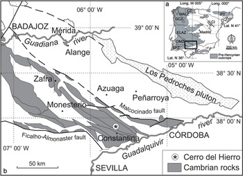
The village of Cerro del Hierro is situated 6 km SW of San Nicolás del Puerto and c. 10 km north of Constantina (Fig. 1b). This landscape is located in the western part of Sierra Morena. Most of the region is now protected as a Natural Park, and the Cerro del Hierro site is recognized as a Natural Monument (Decree 250/2003, BOJA, 188, 30/09/1994) within the Sierra Norte de Sevilla UNESCO Global Geopark.
(a) Tectonostratigraphic zones of the Iberian Massif (after Lotze, Reference Lotze1945; Vera, Reference Vera2004) and other pre-Hercynian outcrops of Iberia (SD, CI, PY, CCR and BC) including the location of Cerro del Hierro (asterix). CZ – Cantabrian Zone; WALZ – West Asturian–Leonese Zone; GZC – Galician–Castilian Zone; ELAZ – East Lusitanian–Alcudian Zone; OMZ – Ossa–Morena Zone; SPZ – South Portuguese Zone; PY – Pyrenees; SD – Sierra de la Demanda. CI – Cadenas Ibéricas (Iberian Chains); CCR – Catalonian Coastal Range; BC – Betic Cordillera. (b) Geographical location of the Cerro del Hierro and Cambrian rocks in the Ossa–Morena Zone (after Liñán & Quesada, Reference Liñán, Quesada, Dallmeyer and Martínez García1990).

2. Geological framework and stratigraphy
Cerro del Hierro is located on sheet number 920 (Constantina) of the 1:50 000 Spanish Geological Map (Angoloti Apolinario et al. Reference Angoloti Apolinario, Muelas Peña and García Vélez1975). The earliest general geological reference (Simon, Reference Simon1951) included a map showing the lithostratigraphic units cropping out in the region. Fabries (Reference Fabries1963) focused on the petrology of the Sierra de Sevilla in his Ph.D. dissertation. The geological map by Angoloti Apolinario et al. (Reference Angoloti Apolinario, Muelas Peña and García Vélez1975) is based on Meléndez et al. (Reference Meléndez, Mingarro and López de Azcona1967). A more detailed geological study of Cerro del Hierro was undertaken by A Miras (unpub. Ph.D. thesis, University of Seville, 1991). His mapping is now slightly revised in the light of new stratigraphic data.
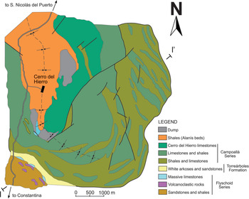
From a regional point of view, Cerro del Hierro is located within the Zafra–Monesterio Domain (Apalategui et al. Reference Apalategui, Eguíluz, Quesada, Dallmeyer and Martínez García1990) of the Ossa–Morena Zone in the Iberian Massif (Fig. 1a, b). From a structural standpoint, Cerro del Hierro represents the eastern limb of an asymmetric syncline. The axial plane has a Hercynian trend (WNW–ESE) in its SE sector, changing to a N–S-aligned trend in the study area (Fig. 2).
Geological map of the Cerro del Hierro area, Sierra Norte de Sevilla (after A Miras, unpub. Ph.D. thesis, University of Seville, 1991; Miras & Galán, Reference Miras and Galán1992).

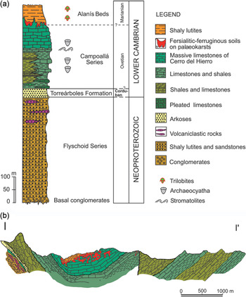
The Cambrian succession of Cerro del Hierro comprises, in stratigraphical order from base to top, the Flyschoid Series (i.e. the upper part of the volcansedimentary complex), the Torrreárboles Formation, the Campoallá Series and the Alanís Beds (Fig. 3).
(a) Stratigraphic section of the Cerro del Hierro). (b) Cross-section (after A Miras, unpub. Ph.D. thesis, University of Seville, 1991; Miras & Galán, Reference Miras and Galán1992).

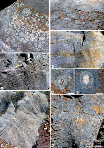
The Campoallá Series (Simon, Reference Simon1951) is a thick succession of shales with discontinuous limestone strata showing pronounced lateral facies shifts with increasing carbonate content towards the west, where massive limestones occur. Some carbonate levels at the base of the Campoallá Series contain stromatolites (Fig. 4a, b), kramenzel structures and/or griotte facies (Schneider in Richter & Richter, Reference Richter and Richter1941; Liñán, Reference Liñán1984). These carbonate levels are related to polymictic alternating levels of centimetric thickness, with a wavy lamination enveloping the carbonate bank shape (Fig. 4c, d). This succession resembles the one found at the base of the Pedroche Formation (lower Ovetian) in the Sierra de Córdoba.
Limestones of the Campoallá Series. (a) Cross-sectional view of stromatolites. (b) Kramenzel structures. (c) Wavy lamination. (d, e) Stromatolitic and laminated limestones. (f–h) Archaeocyaths. Scale bars: (a–e) 10 cm and (f–h) 1 cm.

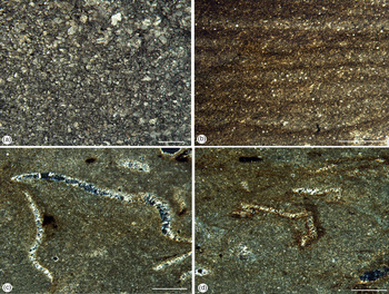
The upper part of the Campoallá Series consists of massive limestones referred to as Cryptozoon–Riffkalke by Simon (Reference Simon1951). These limestones that constitute the Cerro del Hierro itself are partially dolomitized and show spectacular stromatolites at their bases. Bioherms of archaeocyaths and calcimicrobes are frequent in the upper part of the massive limestones (Fig. 4e–h). Some levels are formed by dolomitic limestone, while others contain flint nodules. Thin-sections show that some iron-oxyhydroxides-rich carbonate rocks consist of ferruginous pseudo-oolitic microfacies formed by remains of archaeocyaths (A Miras, unpub. Ph.D. thesis, University of Seville, 1991). The most characteristic limestones in the highest part of the Campoallá Series of the Cerro del Hierro are white and exhibit a mosaic-like microstructure of calcite crystals; these are coarsely equigranular, 0.4 mm in maximum length and 0.08 mm in average size (Fig. 5a), in some cases showing a faint planar lamination. There are some stylolites, recrystallized bioclasts (ghosts of shells) and interstitial clay laminae between the carbonate crystals.
Microfacies. (a) White limestones of the Campoallá Series (scale bar: 500 μm). (b) Laminated yellow-brown limestones filling karstic cavities at the top of the Campoallá Series (scale bar: 2 mm). (c–d) Lutites of the Alanís Beds with abundant sections of trilobites; the shells show small crystals of barite (scale bar: 1 mm).

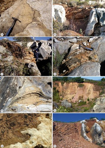
It is important to emphasize the presence of very characteristic yellow-brown laminated limestones in the uppermost part of this formation that are filling irregular cavities and also forming a discontinuous horizon on top of the white limestones. The boundary between the white and the yellow-brown laminated facies outlines a karstic surface (Fig. 6a–e). Thin-sections show that these laminated yellow-brown limestones contain abundant disseminated iron oxides, along with crystals of iron dolomite and ankerite as well as small bioclasts (Fig. 5b). The lamination is mainly the result of a planar arrangement of small iron oxide particles with a grumelar texture. This yellow-brown laminated limestone also contains infillings or small veins of iron oxides up to 1 mm wide.
Field views. (a) Karstic surface between the upper yellow-brown laminated limestones and the white limestones in the uppermost part of the Campoallá Series. (b–d) Different aspects of the karstic cavities showing infill of yellow-brown laminated limestone into white limestone (scale bar in (b): 20 cm). (e) Large symmetrical stromatolites from the Campoallá Series (scale bar: 10 cm). (f) Alanís Beds shales. (g) Unconformity and karren karst surface between the Campoallá Series and the overlying Alanís Beds (scale bar: 10 cm). (h) Karstic surface on top of the Campoallá Series limestone (grey) showing the shales of the Alanís Beds to the left and a laterite karstic infill to the right.

The upper part of the Campoallá Series (Perejón et al. Reference Perejón, Vennin, Moreno-Eiris and Álvaro1999) has yielded the archaeocyaths Nochoroicyathus? sp., Erismacoscinus sp., Alconeracyathus andalusicus (Simon, Reference Simon1939) and Protopharetra? sp. This assemblage indicates an early Ovetian – early Marianian age (Perejón, Reference Perejón1986, Reference Perejón1994; Moreno-Eiris, Reference Moreno-Eiris1987).
The overlying Alanís Beds (Simon, Reference Simon1951) crop out in the core of a syncline (Fig. 3b). They consist of at least 40 m of multicoloured shaly lutites, mostly argillites, that are strongly weathered (usually showing splintering) (Fig. 6f–h). The colour of the beds changes from yellow, pink and greenish in the lower part to greyish (yellowish-grey, whitish-grey and light grey) at the top.
Abundant bioclasts of up to 7 mm long are observed in this thin section, representing fragments of trilobites as well as iron oxides impregnating the rock (Fig. 5c, d). Thin bioclast (0.2 mm thick) may represent thoracic tergites of trilobites. The microstructure of the bioclasts shows small crystals of barite (maximum, 0.2 × 0.015 mm) (Miras & Galán, Reference Miras and Galán1992) replacing the original skeleton. The lower Marianian shales of the Alanís Beds disconformably overlay the Campoallá Series, draping an intra-Cambrian palaeorelief corresponding to a palaeoweathering surface on which a thick lateritic soil developed, that is, a karstic surface. The shales lie directly above the Cerro del Hierro limestones of the Campoallá Series and locally above the mined iron deposits (laterite), which is described in greater detail in Section 4. The disconformity between the two lower Cambrian formations entails a hiatus in the stratigraphic record (Figs 3, 7).
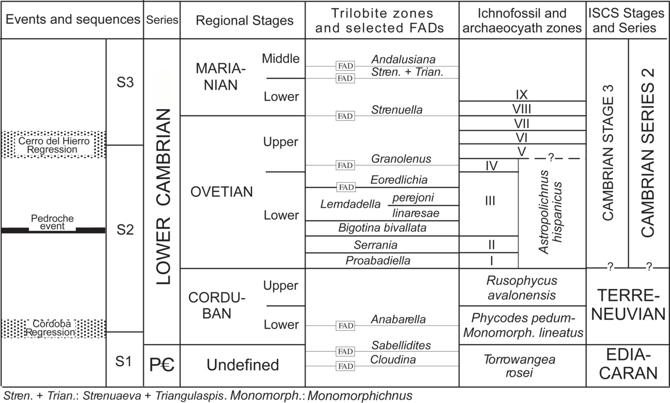
Biochronology of the Terreneuvian and Cambrian Series in the Iberian Peninsula (modified from Liñán et al. Reference Liñán, Gámez Vintaned, Palacios and Gozalo2020 with data from Gámez Vintaned et al. Reference Gámez Vintaned, Schmitz, Liñán, Craig, Thurow, Thusu, Whitham and Abutarruma2009). FAD – first appearance datum.

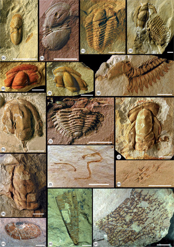
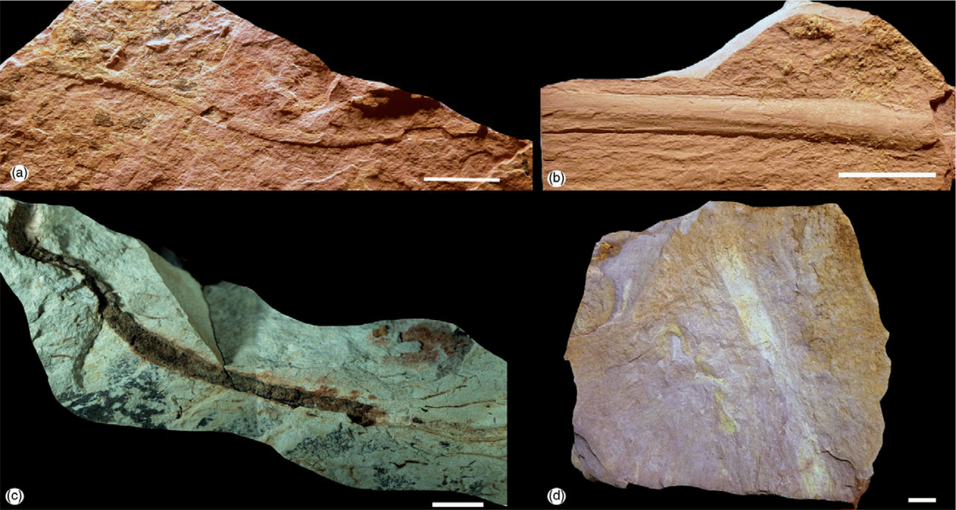
The shales have yielded trilobites (documented by Mayoral et al. Reference Mayoral, Liñán, Gámez Vintaned, Gozalo, Dies, Cuenca Bonilla and Menor Campillo2008), and include the following taxa: Strenuella sp. A, Delgadella souzai (Delgado, Reference Delgado1904), Micmacca? sp., Eops sp. and Saukianda andalusiae Richter & Richter, Reference Richter and Richter1940. Other fossils present are ‘Hyolithes’ sp., trematobolid brachiopods (Sibiria? sp.), algal filaments and sponges, either spicules of Chancelloria hispanica Richter & Richter, Reference Richter and Richter1940 or undetermined remains of their walls. This fauna derives from two levels in the lower part of the Alanís Beds (Fig. 8). The age of the assemblage is early Marianian (Fig. 7) according to Liñán et al. (Reference Liñán, Perejón and Sdzuy1993, Reference Liñán, Gozalo, Palacios, Gámez Vintaned, Ugidos, Mayoral, Gibbons and Moreno2002). Associated ichnofossils are Sericichnus mureroensis Gámez Vintaned & Mayoral, Reference Gámez Vintaned, Mayoral, Gámez Vintaned and Liñán1995, Planolites ichnosp. indet., Palaeophycus striatus Hall, Reference Hall1852 and Palaeophycus ichnosp. indet. (Fig. 9).
The Alanís Beds fauna. (a, b) Delgadella souzai (Delgado, Reference Delgado1904). (c–g) Strenuella sp. A. (h, i) Mimacca? sp.l. (j) Saukianda andalusiae Richter & Richter, Reference Richter and Richter1940. (k) Eops sp. (l) Algal filaments. (m) Spicules of Chancelloria hispanica Richter & Richter, Reference Richter and Richter1940. (n) Trematobolidae brachiopod. (o) Hyolithid. (p) Sponge indet. (scale bar: 1 cm).

Ichnofossils from the Alanís Beds. (a) Palaeophycus ichnosp. indet. (b) Palaeophycus striatus Hall, Reference Hall1852. (c) Planolites ichnosp. indet. (d) Sericichnus mureroensis Gámez Vintaned & Mayoral, Reference Gámez Vintaned, Mayoral, Gámez Vintaned and Liñán1995 (scale bar: 1 cm).

The general sequence stratigraphy established for the upper Ediacaran – lowest Ordovician rocks of the Cadenas Ibéricas (Spain) by Gámez Vintaned et al. (Reference Gámez Vintaned, Schmitz, Liñán, Craig, Thurow, Thusu, Whitham and Abutarruma2009) can be partially recognized within the Cerro del Hierro succession. The Flyschoid Series appears equivalent to the upper Ediacaran sequence (S1), limited at its top by the Córdoba Regression. The overlying Torreárboles Formation and the Campoallá Series represent the lowest Cambrian Sequence (S2) (Figs 3 and 7). It was deposited under an early Cambrian extensional regime, and is delimited upwards by the Cerro del Hierro Regression. The Alanís Beds might reflect the S3 Sequence (Figs 3 and 7).
3. Chronostratigraphy
The lower Cambrian (Terreneuvian and Cambrian Series 2) rocks of Spain were subdivided by Sdzuy (Reference Sdzuy1971) and Liñán (Reference Liñán1984) into the Corduban, Ovetian, Marianian, and Bilbilian regional stages. These stages were introduced due to the marked faunal provinciality in Cambrian times, and they have been widely used by authors from different countries researching the Mediterranean region (see Liñán et al. Reference Liñán, Dies, Gámez Vintaned, Gozalo, Mayoral and Muñiz2005, p. 377). The zonation, defined by Liñán et al. (Reference Liñán, Perejón and Sdzuy1993), is based on trace fossils, trilobites, and archaeocyaths. For the latest revision of zonation, see Liñán et al. (Reference Liñán, Gozalo, Palacios, Gámez Vintaned, Ugidos, Mayoral, Gibbons and Moreno2002, Reference Liñán, Perejón, Gozalo, Moreno-Eiris and de Oliveira2004).
The Ovetian and lower Marianian (Stage 3, Cambrian Series 2) – the regional stages used for biochronological studies of the Cerro del Hierro karst – were first divided into eight archaeocyaths zones (I-VIII) (Perejón, Reference Perejón1986; Perejón & Moreno-Eiris, Reference Perejón and Moreno-Eiris2006). Substages were defined for this interval based on the associated trilobite assemblages (Liñán, Reference Liñán1984; Liñán et al. Reference Liñán, Perejón and Sdzuy1993) and a trilobite zonation was established for the lower Ovetian Substage (Liñán et al. Reference Liñán, Dies, Gámez Vintaned, Gozalo, Mayoral and Muñiz2005, Reference Liñán, Gozalo, Dies Álvarez, Gámez Vintaned and Zamora2008, Reference Liñán, Gámez Vintaned and Gozalo2015, Reference Liñán, Gámez Vintaned, Palacios and Gozalo2020). Correlation of the Spanish regional stages with the main regional, chronological units of the Cambrian has been based on these trilobites and archaeocyathid zones (Liñán et al. Reference Liñán, Gozalo, Dies Álvarez, Gámez Vintaned and Zamora2008, fig. 10; Zhang et al. Reference Zhang, Ahlberg, Babcock, Choi, Geyer, Gozalo, Hollingsworth, Li, Naimark, Pegel, Steiner, Wotte and Zhang2017, fig. 3). The zonation constrains the karst chronology recorded at Cerro del Hierro, including the binternational correlation of the Cerro del Hierro Regression (the event during which the Cambrian karstification took place).
4. The palaeokarst and the related laterite
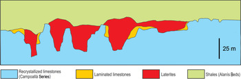
In the uppermost part of the Campoallá Series, palaeokarstic surfaces are covered either by laminated yellow-brown limestones, iron ore (laterite) or shales of the Alanís Beds (Fig. 10).
Schematic cross-section of the Cerro del Hierro area, showing the relationships between the four main facies described in the text and the palaeokarstic boundaries. No horizontal scale.

In Recent times, the laterite cover eroded and was also quarried as an iron ore, yet it is still well preserved locally with a maximum thickness of 50 m. The most common minerals are hematite, goethite, magnetite and barite. The iron mineralization is more widespread in areas where biohermal limestones are thicker. Moreover, pedogenic carbonate and calcrete are absent from the laterites.
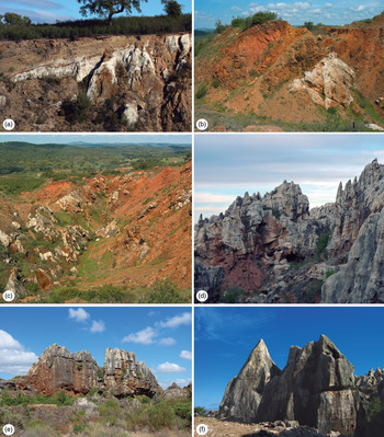
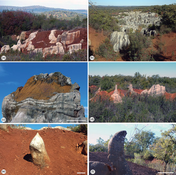
The most obvious identifiable morphological features for the Cambrian karst are ‘arête-and-pinnacle’ (medium-height towers with pointed tops) and ‘ruiniform relief’, with grikes at least several metres wide and up to 500 m long, commonly featuring corridors and labyrinth networks (Fig. 11d–f). The towers are typically 1–30 m high with diameters of 1–20 m. Other typical morphologies are ‘castellated blocks’ with a complicated relief (Fig. 12a, b), and ‘domes’ with rounded tops (Fig. 12d). There are also excellent examples of rounded ‘stone teeth’ or small pinnacles protruding through eroded or quarried laterites (Fig. 12d–f). The karstic system has a maximum depth of 60 m in the deepest cave of Sima del Hierro (Delannoy et al. Reference Delannoy, Díaz del Olmo and Pulido Bosch1989).
Field views. (a, b) General view of the palaeokarstic boundary between the Campoallá Series and the Alanís Beds. (c) Palaeokarstic corridor controlled by fractures trending N 140–150° E; the palaeovalley contains an infill of (mined) laterites. (d–f) Examples of karstic landscape ‘arête-and-pinnacle’ and ‘ruiniform relief’ with grikes, corridors and labyrinth networks at the top of the Campoallá Series.

Field views. (a, b) ‘Castellated blocks’ with complicated relief surrounded and covered by laterite. (c) Dome with a rounded top and uneven infill of laterite. (d–f) Rounded ‘stone teeth’ and small pinnacles emerging from eroded laterites (scale bar: 50 cm).

The development of the Cerro del Hierro palaeokarst was controlled by tectonics, creating lineaments that developed into grikes, and corridors. These features are observable directly in the field or in aerial photographs. The main direction guiding linear karstic corridors and valleys is N 140–150° E (Fig. 11c), while others are N 30° E, N 130° E, N 60° E and N 40° E. Cerro del Hierro is therefore a very complex covered/exhumed palaeokarst. Veress (Reference Veress2016) used the term ‘covered karst’ for all those cases where the karstified rock is covered by non-karstified rock. According to the classification of karst reservoirs published by Zhang & Liu (Reference Zhang and Liu2009), the Cerro del Hierro karstic area could be considered as a buried hill karst, a remnant topography with irregular disconformity surfaces buried beneath lateritic weathered crusts and younger sediments.
5. Genetic interpretation of the palaeokarst and laterites
Most Cambrian carbonates in the Cerro del Hierro area show geomorphological features related to relatively modern karstic processes (Baena & Díaz del Olmo, Reference Baena and Díaz del Olmo1988; Delannoy et al. Reference Delannoy, Díaz del Olmo and Pulido Bosch1989). Some authors (e.g. Perejón et al. Reference Perejón, Vennin, Moreno-Eiris and Álvaro1999) interpreted this as proof against the intra-Cambrian karstification previously inferred by Miras & Rodríguez (Reference Miras and Rodríguez1990). However, geomorphological features indicating an early Cambrian karstification are evident, particularly in places where the carbonates are covered by the Alanís Beds’ shales or by lateritic palaeosoil, and also at localities where the white limestones are overlain by the yellow-brown limestones of the Campoallá Series.
This karstification surface coincides with a hiatus in the stratigraphic record known as the Cerro del Hierro Event (or Cerro del Hierro Regression), which is also recognized in other lower Cambrian successions in Spain. According to Liñán & Gámez-Vintaned (1993), this event is related to a widespread regression that took place during late Ovetian time, at the boundary between the archaeocyath zones V and VI of Perejón (Reference Perejón1986) (Fig. 7).
Essential prerequisites for karstification to take place include the presence of massive limestones and widely spaced, significant joints. Pure, massive limestones are highly rigid, implying that they have developed intense fracturing under tectonic strain. As joints are widened by dissolution in a very humid tropical–subtropical climate, grikes develop.
The source area of the Cambrian lateritic material accumulated in Cerro del Hierro is unclear, and research on its origin remains beyond the scope of the present work. However, in the present work, a few considerations are proposed for future research.
The lack of any gradual downwards change in the grain size, composition or structure, together with the absence of calcretes in the laterites, indicate that the parent material was completely homogenized by pedogenic processes during a long period of soil development. However, the laterite age is unconstrained, but this rock and the soils that form it (oxisols and ultisols) require hundreds of thousands of years to form, even in warm, humid climates. Laterites record exceptionally intense, regionally widespread weathering under tropical regimes with ample rainfall (Bárdossy et al. Reference Bárdossy, Fuchs, Glazek, Bosák, Ford, Glazek and Horacek1989; Bárdossy & Aleva, Reference Bárdossy and Aleva1990). The threshold required for the formation of oxisols, bauxites and laterites includes an average annual precipitation exceeding 1100 mm, and a minimum required temperature (annual mean) exceeding 17°C (Retallack, Reference Retallack2008). Moisture variation is another likely explanation for the episodic lateritization and bauxitization occurring in tropical regions, where precipitation (rather than temperature) is the primary determinant of weathering and the development of ecosystems.
Intense tropical weathering (e.g. Retallack, Reference Retallack2010) is mainly responsible for the enrichment of iron oxides and hydroxides in laterites. A major problem for any model suggesting a weathering origin of laterites is that their iron content and thickness are higher than could be reasonably derived from local bedrock, considering the volume and mass lost by weathering (McFarlane, Reference McFarlane1976; Brimhall et al. Reference Brimhall, Chadwick, Lewis, Compston, Williams, Danti, Dietrich, Power, Hendricks and Bratt1991). Iron could be added by lateral flow of acidic groundwater, creating a highly leached pallid zone (McFarlane, Reference McFarlane1976). A second proposal for the high content of iron is supply from windblown dust (Brimhall et al. Reference Brimhall, Chadwick, Lewis, Compston, Williams, Danti, Dietrich, Power, Hendricks and Bratt1991). An increasing number of authors suggest that aeolian dust is an essential allochthonous source in laterite formation. Development of laterites is not dependent on parent material, as demonstrated by laterites developed on severely iron-poor quartz sandstones near Sydney, Australia (Hunt et al. Reference Hunt, Mitchell and Paton1977). Such observations support the idea that many laterites essentially derive from aeolian dust (Brimhall et al. Reference Brimhall, Chadwick, Lewis, Compston, Williams, Danti, Dietrich, Power, Hendricks and Bratt1991; Liu et al. Reference Liu, Mao, Yuan and Ma2019).
Eustatic falls are known to promote karstification. From a tectonic perspective, karst is common in areas with active uplift.
In some areas, dissolution occurs under the laterite cover, and secondary karstification develops. Laterite formation and karstification can therefore be regarded as parallel processes, and vast areas with karren may evolve beneath a soil cover (Song & Liang, Reference Song, Liang, Ginés, Knez, Slabe and Dreybrodt2009; Veress, Reference Veress2016). Although karren mainly results from dissolution among faults or joints, it is difficult to specify whether it tends to develop beneath sediment cover or on exposed surfaces (Veress, Reference Veress2016).
The ruiniform karst of Cerro del Hierro is a typical landform that develops when the grikes are exposed due to removal of the sedimentary cover (soil). The topography caused by widening of the dividing walls is called ‘pinnacle and corridor karst’ or ‘labyrinth karst’. The presence of such polygenetic karst suggests that it formed in a very humid tropical climate, under a thick ferriferous soil or laterite (e.g. Ford & Williams, Reference Ford and Williams2007; Migoń et al. Reference Migoń, Duszyński and Goudie2017). The irregular relief is the product of a long and complex history, involving the burial of karren and overlying soil by shallow-marine muddy sediments during early Cambrian time, and later re-exhumation and re-karstification during Neogene and Quaternary times. Today, the main karst and pinnacle development occurs beneath the soil. At the same time, the old topography is exhumed and intensified, exposing tracts of pinnacles and other karstic shapes in large patches over an area of more than 300 hectares.
Cerro del Hierro is therefore a very complex covered and/or exhumed palaeokarst. It is not easily distinguishable from more recent karst, since it is difficult to establish the time of karren origin under the cover. It is also a problem to determine whether the karstification developed only under cover sediment (laterite), exclusively on a bare limestone surface or in a combination of these.
It can be concluded that there are several phases of superimposed karstification (polyphase karstification, Molina et al. Reference Molina, Ruiz-Ortiz and Vera1999), with at least two phases occurring during early Cambrian time. The first would have been a minor phase, with the formation of karstic shapes before deposition of the yellow-brown laminated limestones; the second phase was more extensive, with karstification on top of the Campoallá Series (including the laterally discontinuous upper yellow-brown laminated limestones). Subsequently, the laterite genesis from ferruginous palaeosoils took place under humid tropical subaerial conditions, before a Cambrian marine flooding resulted in the deposition of the clays and silts of the Alanís Beds.
According to Boucot & Gray (Reference Boucot and Gray2001), geological data indicate a relatively warm planet Earth during early Cambrian time and a low pole-to-equator climatic gradient that favour the development of karst; recently, Hearing et al. (Reference Hearing, Harvey, Williams, Leng, Lamb, Wilby, Gabbott, Pohl and Donnadieu2018) corroborated the interpretation of an early Cambrian greenhouse state by demonstrating that evaporite and calcrete deposits occur over a wide palaeolatitudinal range, and that deposition of tropical soils (laterites) took place at high palaeolatitudes.
Evidence for early Cambrian shallow-marine and land environments comes from supratidal and intertidal palaeokarsts and fluvial palaeosoils (see Retallack, Reference Retallack2008). Reddened palaeokarsts observed in the Wilkawillina and Ajax limestones of southern Australia and other local shallow-marine carbonates with archaeocyaths suggest that local red breccias and palaeokarst originated by dissolution during subaerial exposure (Clarke, Reference Clarke1990; Zang, Reference Zang2002). One remarkable early Cambrian palaeokarst of regional extent in southern Australia is known as the Flinders Unconformity (James & Gravestock, Reference James and Gravestock1990). Betts et al. (Reference Betts, Paterson, Jago, Jacquet, Skovsted, Topper and Brock2016, Reference Betts, Paterson, Jago, Jacquet, Skovsted, Topper and Brock2017) recently studied the biostratigraphy of this interval, and demonstrated the presence of the lower Marianian trilobite Alanisia guillermoi Richter & Richter, Reference Richter and Richter1940 in the Mernmerna Formation just above this unconformity (Betts et al. Reference Betts, Paterson, Jago, Jacquet, Skovsted, Topper and Brock2017, fig. 3). The unconformity appears to be of the same age (at least approximately) as the Cerro del Hierro karstification. The unconformity in the Flinders Ranges separates the local sequences 1 and 2 (see Betts et al. Reference Betts, Paterson, Jago, Jacquet, Skovsted, Topper and Brock2017), and is erosional at most localities, exhibiting both surface karst and large open fractures interpreted as solution-enlarged joints and karst valleys. The hiatus resulted from a relative fall of the sea level but, at the same time, extensional fault reactivation led to differential subsidence. This break is also recognizable in shelf facies rocks on the Yorke Peninsula near Adelaide (see Betts et al. Reference Betts, Paterson, Jago, Jacquet, Skovsted, Topper and Brock2016, fig. 22).
Further examples of early Cambrian karsts can be found in the Lower Caledonides of the Altai–Sayan region, where they are overprinted by a more widely developed Cretaceous–Palaeogene karstification, as well as in other areas of the Siberian Platform (Bosák et al. Reference Bosák, Ford, Glazek and Horacek1989).
6. Karst chronology
The presence of archaeocyaths in the limestones below the karst surface and of trilobites in strata above it provides clues to date this karstification event. The archaeocyath genera are Nochoroicyathus and Protopharetra (although identified with doubt, according to Perejón, Reference Perejón1994), and range through archaeocyathid zones I (lower Ovetian) to IX (lower Marianian). This author indicates that the genus Erismacoscinus has the same range. Alconeracyathus andalusicus (Simon, Reference Simon1939) is also long-ranging (lowermost Ovetian—Marianian; Moreno-Eiris, Reference Moreno-Eiris1987, p. 116). Hence, these archaeocyathid taxa do not constrain their position within the lower Cambrian to any degree of detail.
The trilobites recorded from the Alanís Beds include Strenuella sp. A, Saukianda andalusiae Richter & Richter, Reference Richter and Richter1940, Eops sp., Micmacca? sp. and Delgadella souzai (Delgado, Reference Delgado1904). Saukianda andalusiae and Eops belong to the early–middle Marianian so-called Alanís fauna (Richter & Richter, Reference Richter and Richter1940). At Cerro del Hierro, these trilobites are associated with other taxa such as Strenuella sp. A, Micmacca? sp. and Delgadella souzai. These taxa are associated with Saukianda and Eops at the Galeón stream locality, in intervals where Perejón (Reference Perejón1994) identified an archaeocyath association characteristic of the archeocyath zone VIII (lowermost Marianian). Strenuella sp. A is also associated with Saukianda andalusiae, Micmacca? sp. and Delgadella souzai in level 10 in the Alconera-1 section (A1), an association considered as early Marianian in age (Liñán & Perejón, Reference Liñán and Perejón1981). According to these data (Fig. 7), the Alanís Beds trilobite assemblage in Cerro del Hierro is early Marianian in age, while the most likely age for the karstification is late Ovetian, as interpreted by Liñán & Gámez-Vintaned (1993) when they defined the Cerro del Hierro Regression. This event is manifested in the Iberian Peninsula and correlates with similar events in England (Woodlands Regression; Brasier, Reference Brasier1985, Reference Brasier and Walliser1995), Sardinia (Cerro del Hierro Regression; Pillola et al. Reference Pillola, Leone and Loi1995), South America (Astini & Vacari, 1996) and Australia (Flinders Unconformity; Betts et al. Reference Betts, Paterson, Jago, Jacquet, Skovsted, Topper and Brock2017).
The trilobite record suggests that, because of the Cerro del Hierro Regression, the Cerro del Hierro area became emergent for a longer time than other areas of the Ossa–Morena Zone and also than the rest of Iberia (Liñán et al. Reference Liñán, Gámez Vintaned, Pillola and Gozalo2016). As a result, all the upper Ovetian rocks (deposited during archaeocyath zones V to VII) were sealed during early Marianian times by a substantial lateritic horizon, followed by the sedimentation of the marine, fine-grained siliciclastics of the Alanís Beds. The sea-level rise probably responded to tectonic forcing in the context of the horst and graben model that produced the Cambrian rift phase in Ossa–Morena (Liñán & Quesada, Reference Liñán, Quesada, Dallmeyer and Martínez García1990). This could explain the stratiform appearance and the exclusive location of the iron mines of Cerro del Hierro, which are absent from other wider Cambrian outcrops of Ossa–Morena.
7. Neogene–Quaternary karstification
The Hercynian Orogeny folded and fractured all strata in the area, producing the structural setting that allowed the development of the truly spectacular karstification that we observe today. Its appearance is, however, affected by the previous, Cambrian palaeokarst morphology. The most noteworthy features are: (1) a substantial decrease of the base level that caused the development of deep depressions; (2) ridges and sharp edges; (3) dissolution and collapse structures related to barite mineralization; and (4) local formation of stalagmites and/or small calcite curtains (Miras & Rodríguez, Reference Miras and Rodríguez1990). So far, there are no reliable data on the exact age of the superimposed modern karstification. The most significant features observed would be the regional (SK1 at 680-670 m above sea level) and local (SK2 630-620 m) peneplains described by Baena & Díaz del Olmo (Reference Baena and Díaz del Olmo1988). Both surfaces are karstified with the development of dolines, while the SK2 also displays open poljes.
The SK1 and SK2 surfaces on limestone via crypto corrosion processes during the Neogene. The inferred ages are Miocene for the SK1 peneplain and Pliocene for the SK2 peneplain (Baena & Díaz del Olmo, Reference Baena and Díaz del Olmo1988; Delannoy et al. Reference Delannoy, Díaz del Olmo and Pulido Bosch1989). According to Schwarz (Reference Schwarz1997), intense chemical weathering during middle Miocene time led to the formation of deep ferralitic weathering profiles (lateritic bauxite) in central Germany. This provides evidence of a short global climatic optimum or warming phase at c. 171–4.5 Ma, reflecting an intensified global greenhouse state with increased precipitation, chemical weathering and laterite formation.
The Cerro del Hierro topography is therefore the product of a long and complex history, involving early Cambrian karstification and lateritization as well as the burial of karren and laterites. Exhumation and re-karstification reappeared mainly during the Neogene–Quaternary period. The old Cambrian ruiniform relief developed beneath a lateritic deposit that was exhumed and intensified, exposing tracts of pinnacles and other karstic morphologies in large patches over an area of more than 300 hectares.
8. Discussion and conclusions
The interpretation presented here disagrees with the regional and sedimentological conclusions of Perejón et al. (Reference Perejón, Vennin, Moreno-Eiris and Álvaro1999). The new data corroborate the interpretations published in previous works regarding the presence of a Cambrian karst in the area related to a regressive event, the so-called Cerro del Hierro Regression. This widespread event has also been recorded in Sardinia and in England, where it is known as Woodlands Regression.
The palaeokarst studied here falls into the category of cryptokarst (a covered karst with an impermeable sedimentary cover), and is also an excellent example of an exhumed karst, a category of fossil karst whose features are exposed once the strata that covered it for some time have been eroded (Veress, Reference Veress2016). Newly exhumed karst surfaces typically formed under different climatic conditions; the macroforms have an older, fossil origin, whereas most of the microforms may be of a modern origin (see discussion in Sweeting, Reference Sweeting1972; Bosák et al. Reference Bosák, Ford, Glazek and Horacek1989).
The regional palaeogeographical evolution is one of syndepositional faulting within a passive margin, differential subsidence and relative sea-level changes. Carbonate platforms developed, with local emergence in the highs and deposition of lutites and other deeper facies in adjacent basins. During early Cambrian time, karst and lateritic soils developed in the highs.
The early Cambrian palaeokarst phases described here are closely related to the rifting evolution of the Ossa–Morena Zone. They coincided with eustatic sea-level drops amplified by either local or regional tectonic events, commonly involving block-tilting related to the movement of listric faults (differing in magnitude in each palaeogeographic–palaeotectonic domain). This model of polyphase karstification in an extensional tectonic regime resembles that proposed by Molina et al. (Reference Molina, Ruiz-Ortiz and Vera1999) for the Mesozoic strata of the South Iberian Margin. In the case of polyphase karstification, successive karstic processes modify earlier features but are also conditioned by them. This interdependence complicates the attempts to isolate individual karst events. In the case of Cerro del Hierro, it is very difficult to distinguish between landforms developed during Neogene–Quaternary regimes and those that were inherited from Cambrian palaeokarsts and later modified by modern processes.
Acknowledgements
We thank Professor Per Ahlberg and an anonymous reviewer for their constructive reviews, as well as Dr Isabel Abad (University of Jaén) for the X-ray diffraction analysis and Professor Pedro A. Ruiz-Ortiz (University of Jaén) for assistance in the field. This work is a contribution to Project CGL2015-66835-P (MICIN+FEDER) by research groups RNM-200 and RNM-276 of the Junta de Andalucía, Science and Technology Research Centre, University of Huelva, the GIUV2017-395 research group of the Universitat de València, and IGCPs 652 and 668.