

Introduction
(Richard Bradley)
This article discusses a series of places along the British coast which are associated with exceptional collections of artefacts dating from the period between 4000 and 2000bc, although activity sometimes extended outside that range. With just one exception, they are found in the area of isostatic uplift where the ancient shoreline survives. None has been recorded in much detail and most of the original findspots are inaccessible today. Nevertheless they bear a striking resemblance to a series of early medieval sites, some of them in the same locations. Both groups are associated with large numbers of artefacts, including objects of non-local origin, and with striking evidence for craft production. The early medieval examples were where travellers embarked and landed – they provided neutral locations where strangers came in contact with one another and where objects were made and exchanged. In recent years historical archaeologists have described such sites as ‘beach markets’, but when prehistoric material of similar character is found there, it is seldom discussed.
That is unfortunate as it identifies an element that is missing from the maritime archaeology of the earlier prehistoric period. Instead it has investigated other issues. There have been important accounts of sea levels and the evolution of the coast, marine currents, and prevailing winds (Van de Noort Reference Van de Noort2011; Sturt et al. Reference Sturt, Garrow and Bradley2013). Other writers have considered the sea routes leading between different regions (McGrail Reference McGrail1993; Callaghan & Scarre Reference Callaghan and Scarre2009). There has been an emphasis on the relationship between logboats, skin boats, and more sophisticated craft. Which were used for inland travel, and which were better suited for long distance voyages? Van de Noort (Reference Van de Noort2011) considers the history of maritime technology in the British Isles. The direct evidence is limited, but the first plank-built vessels so far recorded date from the Early Bronze Age. As he says, it may be no accident that the few surviving traces of such boats are in regions which provide evidence of connections with the Continent at this time (Van de Noort Reference Van de Noort2011, chap. 8).
Where did these vessels come from, and where did their crews disembark? There are numerous signs of contacts between different parts of Britain, some of which must have been by sea, but the role of natural harbours has hardly been discussed. Recent research has emphasised the importance of long distance travel from the Neolithic period onwards, whether it was concerned with the introduction of domesticates, the acquisition of artefacts and materials, or the transmission of religious beliefs and the practice of pilgrimage (Sheridan Reference Sheridan2010; Anderson-Whymark & Garrow Reference Anderson-Whymark and Garrow2015; Wilkin & Vander Linden Reference Wilkin and Vander Linden2015), but there is little to show how any of these connections were formed. Large numbers of people may have assembled at enclosures and others could have gathered for funerals (Oestigaard & Goldhahn Reference Oestigaard and Goldhahn2006), but this was often a feature of inland areas. Is there comparable evidence from the shoreline?
It is here that prehistorians can learn from their colleagues who study later periods. Two kinds of site have featured in recent research: ‘landing places’ and ‘maritime havens’. There is a fine distinction between them, for the term ‘haven’ implies a sheltered mooring which could have been employed over a period of time. ‘Landing places’ played a more ephemeral role and for that reason they are more difficult to identify (Ilves Reference Ilves2009). Historical archaeologists have also studied the social and economic significance of these locations (Loveluck & Tys Reference Loveluck and Tys2006), and their work investigates the relationship between inland communities and people who lived by the sea. Our paper considers an earlier period in which skin boats may have been used for long distance travel and advocates a new integration between maritime and terrestrial archaeology.
It has several components: it begins by considering the specialised locations that historical archaeologists have interpreted as ‘beach markets’. Several are associated with large collections of earlier prehistoric artefacts, but these finds have not been considered in the same terms. This article presents a new analysis of the prehistoric material from the Culbin Sands in north-east Scotland which includes some obvious imports and provides evidence of craft production. The dunes were located at a river mouth. They were cut off from the surrounding region and associated with a sheltered harbour that provided access to the hinterland. These features recall the role of Culbin during the Iron Age and Pictish periods, when it is likely that this prominent headland was outside the normal pattern of settlement.
The earlier prehistoric archaeology of Culbin shares many features with that of Hengistbury Head and the Luce Sands – two places whose earlier prehistory has been investigated in recent years. A common element is their topography which they share with the findspots of similar collections from the coast. All are in regions where the ancient shoreline survives, and this account offers a new reconstruction of the local sea levels. Such places were associated with sheltered harbours and were separated from open water by offshore islands or bars. Most were at river mouths and are characterised by sand dunes today. Again comparison with the early historical period suggests that these were among the pivotal locations in a pattern of maritime contact. In most cases they were offset from the distribution of large prehistoric monuments which were confined to inland areas. This study considers the wider implications of such evidence in relation to maritime travel during earlier prehistory and suggests how the model might extend to regions in which the ancient coast has been submerged.
The Shoreline in Prehistoric and Historical Archaeology
(Richard Bradley)
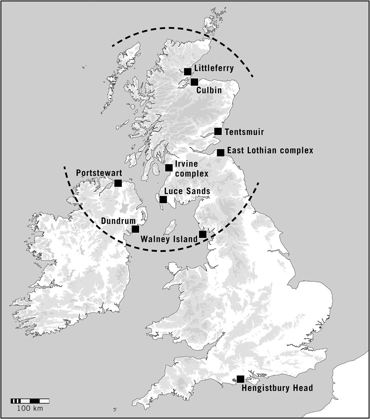
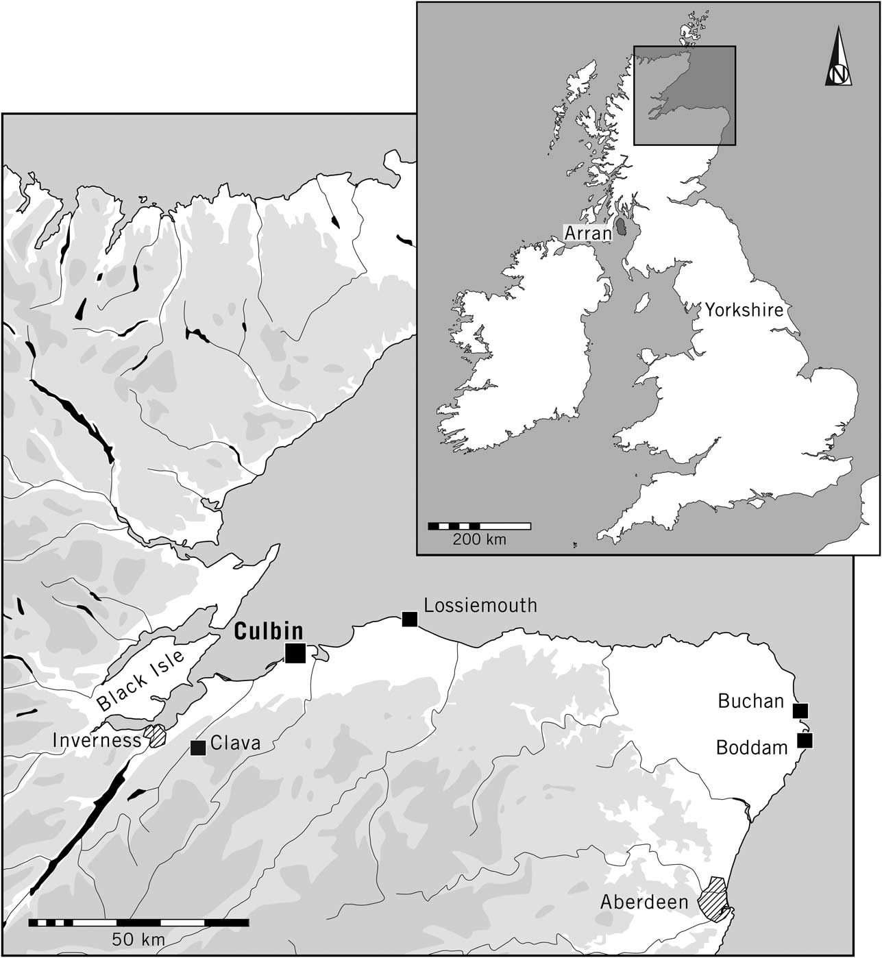
If similar phenomena have been identified by prehistorians and historical archaeologists, those common elements have seldom been compared. This is especially apparent at the most extensive of all these complexes, the Culbin Sands in north-east Scotland (Fig. 1). They are located on the Moray Firth which provides access from the North Sea to the Great Glen – an important route to Ireland. The artefacts recovered from the dunes represent one of the largest collections from anywhere in Britain (National Museum of Antiquities 1892), but accounts of this material have been divided between the Iron Age and Pictish periods, on the one hand (Carver Reference Carver1999, 57), and the Neolithic, Chalcolithic, and Early Bronze Age, on the other (Black Reference Black1891; Callander Reference Callander1911; Clarke Reference Clarke2004). The later material can be related to discoveries in the surrounding area. The metalwork and Roman imports resemble artefacts found at settlements, and the remarkable group of material dating from the 1st millennium ad emphasises the close relationship between the dunes and the defended centre at Burghead, 8 km to their east. The entire complex is associated with Findhorn Bay and with two rivers leading to the hinterland. Martin Carver (Reference Carver1999, 57) has interpreted Culbin as a place where strangers could exchange goods.
The location of Culbin and other coastal sites discussed in this article. The dashed line represents the extent of isostatic uplift. Two sites of similar character in Northern Ireland are also shown

The earlier prehistoric material has been considered separately. The quantity and variety of finds have been discussed on several occasions (Callander Reference Callander1911; Ross Reference Ross1992; Clarke Reference Clarke2004), but there has been little attempt to explain them. Because of the abundance of flint arrowheads (there are 1100 in the largest museum collection alone: National Museum of Antiquities of Scotland 1892, 90–2) it was tempting to suppose that the area was used for hunting and fishing. Alternatively, the size of the collections was explained by the ease of finding artefacts when sand was moved by the wind (Clarke Reference Clarke2004). The enormous assemblage from Culbin has been compared with finds from other dune systems in Britain (Callander Reference Callander1933; Lacaille Reference Lacaille1954), but that comparison was based on the process of discovery. The ideas that influenced the historical archaeology of coastal sites have not extended to their earlier prehistory.
A second example of the presence of older material on the site of a later beach market is Hengistbury Head in southern England (Cunliffe Reference Cunliffe1987). In this case the main period of activity was during the late Pre-Roman Iron Age, when it was associated with evidence of metalworking, coin production, and the making of glass. Artefacts and raw materials were introduced from a wider area, and there was an assemblage of coins, amphorae, and other vessels that had been imported from the Continent. It was defended by an earthwork, and, like the early medieval site at Culbin, it may have been a liminal place where traders could transact with the local inhabitants. Hengistbury Head was identified as a ‘gateway community’ and may have been situated on a territorial boundary (Cunliffe Reference Cunliffe1987, 339–45). The headland commanded the entrance of Christchurch Harbour and the mouths of two important rivers providing access to the interior of Wessex.
Like the Culbin Sands, Hengistbury Head had an exceptional character during the earlier prehistoric period, but in this case it was only acknowledged when the results of excavation were published (Gardiner Reference Gardiner1987). The evidence will be discussed in a later section of this paper, and it is necessary to mention only a few of its unusual elements. It included a large assemblage containing a number of specialised artefacts, imported objects, and raw materials. In the vicinity there was also a series of round barrows associated with Bronze Age burials.
Those burials play an important role in Stuart Needham’s study (2009) of Early Bronze Age coastal communities. On analogy with land-based ‘territories’, he has coined the term ‘maritory’ to express the close relationship between people living by the sea on both sides of the Channel and exercising some control over the movement of resources and goods (Needham et al. Reference Needham, Parfitt and Varndell2006). This is most apparent from richly furnished burials which share similar characteristics from Brittany to the Rhine and from Cornwall to Kent. The barrows on Hengistbury Head form part of this wider pattern. There is an important contrast between this system and the kind of long distance axis represented by the North Sea littoral where prehistoric navigators could have stayed close to the shore instead of crossing open water. That is particularly relevant to our discussion of Culbin.
Why have these places attracted so little attention? A recent article by Garry Robinson (Reference Robinson2013) considers the importance of prehistoric landing places and harbours in the Scilly Islands and discusses their relationship to settlements and monuments on dry land. Unfortunately, there are few studies of this kind, and Robinson was working in a region where the ancient shoreline is submerged. The same applies to large parts of England and Wales and for that reason the coast is seldom considered in accounts of maritime archaeology. Another difficulty is that there is no direct evidence of seagoing vessels in Britain before the Early Bronze Age (Clark Reference Clark2002; Van de Noort Reference Van de Noort2011). Older logboats are known from inland waters, but the long distance movement of staples, raw materials, artefacts, and ideas provides the only evidence of longer voyages. From the Mesolithic period people must have travelled by sea, but they left no direct evidence of how it was accomplished. Understandably, more research has been devoted to later periods.
One way of redressing this problem is to consider the places where those voyages may have started and ended. Hengistbury and Culbin have much in common. Christchurch Harbour is protected from the English Channel by the mass of Hengistbury Head, and Findhorn Bay is in the lee of the Culbin Sands. Both these places provide sheltered harbours even today. In fact their modern topography results from a similar process, for in each case a major river carries sediment downstream until it is reworked by the sea. Sand or gravel bars develop where the currents converge (May & Hansom Reference May and Hansom2003; Davidson-Arnott Reference Davidson-Arnott2010; Warren Reference Warren2013). Sometimes they form around the positions of offshore islands. Behind those natural features there is still water.
The records of earlier prehistoric coastal sites leave much to be desired. In large parts of England the original shoreline has been lost and it is only in areas of isostatic uplift that much evidence survives. Even here there are problems. The bars that provide protection for small craft are constantly shifting and as the sea level fell large areas of sand were exposed and blown inland. There is little to show when the bars and dunes developed or how their positions changed. It is difficult to reconstruct the original topography, but where these features include large numbers of artefacts in fresh condition they must have existed in some form during the prehistoric period. Most of the material was recovered from sites that are difficult to investigate today. Coastal dunes like those at Culbin have been stabilised by planting trees; others are used as golf courses; and the marginal location of some sites has led to their modern roles as military installations, bombing ranges, airfields, or industrial estates. The Stevenston Sands were chosen by Alfred Nobel as the site of an explosives factory. As a result of these problems there is no longer much prospect of carrying out targeted fieldwork.
For that reason the main emphasis must be on the collections formed while these places were still accessible. In most instances that happened during the late 19th and early 20th centuries and there have been few additions to the record since then. The results of this early work present a number of difficulties. Few finds have accurate provenances and there is little information on the circumstances in which they were recovered. It is not known whether certain kinds of material were chosen at the expense of others, nor is it clear whether they were taken from intact deposits – the obvious exceptions being the contents of burials and shell middens. Most of the finds, even those documented in local and national journals, remained in private hands or were dispersed between different institutions. As a result there is no way of telling how many were originally present or what happened to them after they were discovered. Two excavations on the Luce Sands are among the very few for which useful information is available (Cowie Reference Cowie1996; Coles et al. Reference Coles, Sheridan and Begg2011).
The situation is still more complex because of the distinctive character of many of the deposits in which these artefacts were found. The excavators of the Middle Saxon coastal site of Sandtun in Kent describe the problem:
‘Sand dunes are one of the most complex environments from which to recover archaeological evidence. Dunes have considerable potential for the preservation of remains because substantial depths of sand can be deposited rapidly, leading to the survival of deposits and structures. But equally the looser sand may be removed by wind-blowing, a process known as deflation, and poorly consolidated sand can slump into the hollows left behind. Deflation also may lead to ‘winnowing’ by which heavier material is left as sand blows away and remains of a number of periods become deposited in a single layer (Gardiner et al. Reference Gardiner, Cross, Macpherson-Grant and Riddler2001, 205–6).
Depending on prevailing conditions, sand may blow inland, as it did at Culbin, or dunes extend out from the original shoreline in the way that happened at Tentsmuir or Luce Bay. Artefacts are discovered on the ground surface where dunes have blown away completely, but they can also be associated with different parts of the same deposit. In such cases many of these objects will be in secondary contexts.
There is another reason why the artefacts associated with sandhills can be overlooked by prehistorians. Surprisingly, the most recent general account of ‘dune settlements’ in northern Britain was published more than 60 years ago. Lacaille (Reference Lacaille1954) was studying places where the ancient shoreline survived and was interested in the mixture of Mesolithic and later prehistoric artefacts found together on the coast. He came to the conclusion that they were occupied by communities of hunter-gatherers long after inland regions had been settled by farmers:
‘Generations of food-gatherers … lived after the manner of their Old Stone Age ancestors, notably at sandy sites … They came into contact with more advanced invaders … [but] there was little connection between the primitive food-collectors and the settlers who practised agriculture and expressed religious ideas in megalithic structures’ (Lacaille Reference Lacaille1954, 313–4).
For that reason these sites aroused little interest.
Underneath The Scottish Sahara
(Richard Bradley, Aaron Watson, Ronnie Scott & Fraser Sturt)
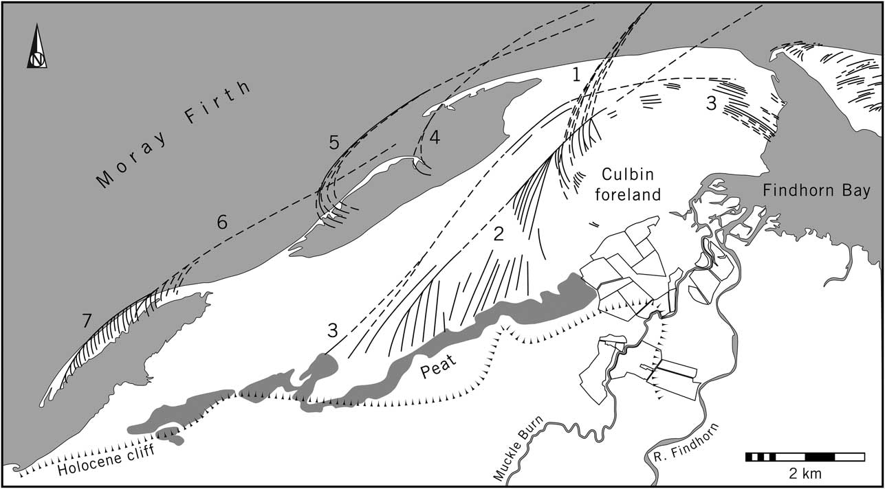
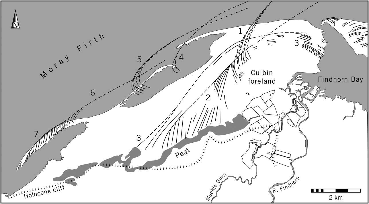
The biggest and most varied collection of earlier prehistoric artefacts is from the Culbin Sands. They are the largest dune system in Britain and have been described as the ‘Scottish Sahara’ (Steers Reference Steers1937; Gould Reference Gould1981; Ross Reference Ross1992; May & Hansom Reference May and Hansom2003, 529–30 & 567–75). Today they extend for 16 km along the southern shore of the Moray Firth between the Rivers Nairn and Findhorn, but in the past they covered a smaller area. At their eastern limit there is a sheltered harbour, Findhorn Bay, and a former wetland (Fig. 2). The environmental history of this region has been studied in some detail, but the chronology of the dunes is difficult to establish. It is uncertain when they first formed, but it is known that the Middle Bronze Age shell midden published by Coles and Taylor in 1970 overlay a deposit of wind-blown sand. Documentary evidence suggests that some of the dunes developed during the Middle Ages and continued to grow until the 20th century (Ross Reference Ross1992). Large numbers of objects were exposed as these deposits moved. Most of them were collected before the ground was stabilised by planting trees.
Map of the Culbin Sands showing the successive shingle bars, numbered 1–7 (after May & Hansom Reference May and Hansom2003), where 1 is the oldest and 7 the most recent. The map also shows a fossil cliff running parallel to the modern coastline and the River Findhorn, and a deposit of peat forming part of a former wetland (information from Gould Reference Gould1981; Ross Reference Ross1992; May & Hansom Reference May and Hansom2003). The ‘Culbin foreland’ is where artefacts were found in great numbers in the 19th and earlier 20th centuries; their precise locations were rarely recorded. The individual fields shown south-west of Findhorn Bay are those surveyed in 2014
The largest groups of finds from the Culbin Sands are in the collections of National Museums Scotland (NMS) in Edinburgh and the museums in Elgin and Forres, but it is clear that these represent only a fraction of what was originally recovered. It is obvious that retouched artefacts were collected at the expense of others. Few of the findspots were recorded in any detail. It is impossible to tell where most of the objects were discovered or which ones were found together, but it is known that they came from a series of concentrations exposed on shingle ridges beneath the dunes (Ross Reference Ross1992, 91–2). The condition of the museum material suggests that many of the worked flints had been abraded by sand.
It is estimated that 29,500 artefacts came to the National Museum of Antiquities (now NMS) in Edinburgh alone. Their chronology extends from a few Mesolithic microliths and blades to numerous artefacts of Chalcolithic/Early Bronze Age date. It is known that all these finds came from the ‘Culbin foreland’: the eastern section of the dunes bounded by Findhorn Bay to the east, a series of fossil beachlines to the south and west, and the present shore of the Moray Firth. It extends over an area of approximately 10 km2. Most of the artefacts were in local concentrations whose exact positions are no longer known, and it is clear that there was never a single focus.
The collections raise many problems. In the light of what has been said already these questions seem particularly important:
-
∙ How distinctive was the coastal landscape around Findhorn and the Culbin foreland? Could it have provided a sheltered harbour during the prehistoric period in the way that it does today?
-
∙ Is the size and character of the artefact assemblage from the Sands a product of the ways in which it has been collected? How does it compare with collections from the surrounding area?
-
∙ Is there any evidence for the long distance movement of earlier prehistoric objects or raw materials? Were any artefacts made at Culbin itself?
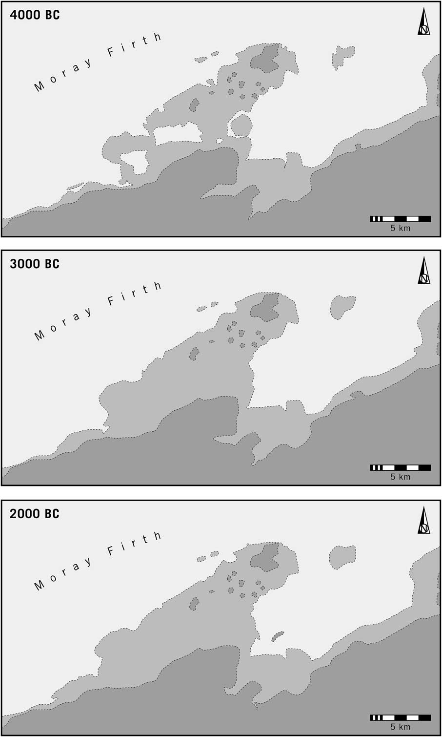
There have been several studies of former beaches around Findhorn Bay (Steers Reference Steers1937; Ross Reference Ross1992; May & Hansom Reference May and Hansom2003, 567–75). The work began before the dunes were afforested, and has been supplemented by aerial photography. Another approach combines topographical information from dry land with submarine contours to provide a detailed reconstruction of the coastline at different times in the past (Fig. 3). This employs the model developed by Sturt et al. (Reference Sturt, Garrow and Bradley2013). In the case of Culbin it suggests that the area with the artefacts was virtually an island, commanding the approach to a harbour and a river mouth. This was the situation at the end of the Mesolithic period, but over the course of time the area separating Culbin from the land to its south gradually dried out. Radiocarbon dates suggest that it had happened by the Late Neolithic or Early Bronze Age (May & Hansom Reference May and Hansom2003, 567–75). The reclaimed silts do not seem to have been farmed until the medieval period and require careful drainage even today. Between about 4000 and 2000 bc the raised ground to their north was effectively cut off from its surroundings. The extent of Findhorn Bay may have changed over time, but throughout this period it could have sheltered travellers along the Moray Firth.
Outline reconstructions of the changing coastline at Culbin between 4000bc and 2000bc. Light shading indicates areas between 0 and 5 m above mean sea level. Higher ground is shown in dark tone

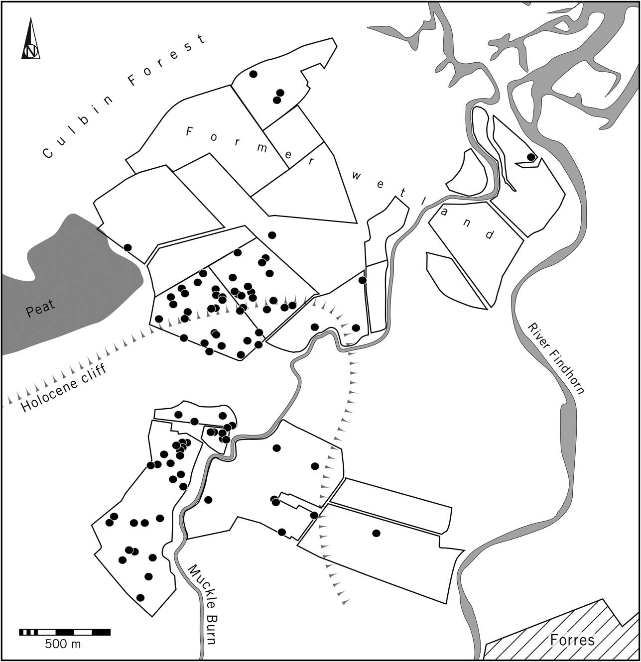
The distinctive character of the assemblage from the Sands raises other questions. The best way of approaching it is to compare the artefacts recovered before Culbin Forest was planted with those in the nearest cultivated land. In 2014 a programme of fieldwalking took place immediately south of the area in which these discoveries were made. It covered a former wetland between the Findhorn and a tributary, the Muckle Burn, and extended to the well-drained soils to their south and west. The fields were walked at 20 m intervals. Metre-wide transects totalling nearly 500 km were investigated.
The spacing of these transects means that they recorded 5% of the material exposed on the ground surface, so it is necessary to multiply the results by 20 to estimate the number of artefacts present. The quantity was remarkably low and only 101 were found. There are various estimates of the proportion of finds exposed by cultivation (Lewarch & O’Brien Reference Lewarch and O’Brien1981), but adopting a conservative estimate that 5% of those in the ploughsoil are visible at any one time suggests a density of about 43 per ha.
This work identified an even scatter of lithic artefacts on the more fertile soils overlooking the wetland that extends inland from Findhorn Bay. A few isolated finds also came from islands of higher ground in the reclaimed land between the river and the Muckle Burn (Fig. 4). The total number of artefacts in the Culbin survey is lower than it was in similar surveys 30 km to the east and north-east respectively (Bradley Reference Bradley2000, chap. 9; Phillips Reference Phillips2002, 270–94), but is of the same order of magnitude. All three projects shared a common methodology and some of the same participants. The finds from the arable land beside the Sands lack chronologically diagnostic forms, but can be dated on technological grounds to the Neolithic, Chalcolithic, and Early Bronze Age periods. Many consisted of small flakes, and fragments of cores which had been worked down until no useable material remained.
The fields surveyed in 2014, showing the distribution of lithic artefacts focussing on the fossil cliff line above a former wetland. Note that the area in between the two blocks of fields illustrated here was under grass at the time fieldwork took place

Sixty per cent of the artefacts are of flint and 32% are of quartz or quartzite. The remaining 8% are of silcrete – a raw material which has only recently been identified (Ballin Reference Ballin2014; Ballin & Faithfull Reference Ballin and Faithfull2014). There are problems in establishing the sources of these materials. Sinclair Ross (Reference Ross1992, 174) conducted a detailed study of the composition of eight beaches or shingle ridges at Culbin and locations to its east and west. Flint accounted for a minute fraction of only two of these deposits, but the coastline has changed since human activity began during the Mesolithic period, and it would be wrong to rule out the possibility that beach flint was employed. That would account for the use of poor quality pebbles among the artefacts in the museum collections, as well as those found by surface collection. It would also explain the small size of many of the arrowheads. As well as flint, vein quartz and quartzite were present in all of Ross’s samples.
How are the results of fieldwalking related to the artefacts from the Sands? Estimates based on the area immediately south of the dunes suggest that the Culbin foreland should have contained at least 40,000 artefacts. It is recorded that nearly 30,000 were sent to the National Museum in Edinburgh, which holds the great majority of the known finds (National Museum of Antiquities 1892, 90–5; Ross Reference Ross1992, 88); there are several hundred in the other collections. Since these items were not acquired by systematic survey and were found where the sand was eroding, the figure of 40,000 must be a considerable underestimate. Debitage was rarely retained and it is clear that worked quartz was overlooked completely. In the fieldwork undertaken in 2014 this raw material accounted for a third of the artefacts. On any reckoning the number of finds from the dunes must have been exceptional.
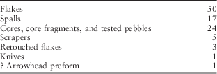
Large numbers of flakes were observed beneath the sand although they were seldom retained. This implies that much of the flint was being worked at the individual sites. The museum collections contain a few bags of debitage that may have been found together. Burnt pieces are especially common. Together with the presence of numerous scrapers and knives, it suggests that there were periods of sustained activity or repeated visits to the Culbin foreland. Similar artefacts were found during fieldwalking in 2014, but there were many fewer of them (Table 1).
Lithic Artefacts From Fieldwalking South Of The Culbin Sands

Among the small collection found in 2014 there was one possible preform for a barbed and tanged arrowhead. The arrowheads from the Sands themselves are more informative and much more common. Their representation varied over time. Barbed and tanged examples are commonest (61%), followed by leaf-shaped arrowheads (29%). Oblique examples also occur, but are less often represented (10%). Many of these pieces were broken or abandoned because of flaws in the raw material. Others could have been discarded because they were not aerodynamic. That is especially true of the Chalcolithic and Early Bronze Age examples. The presence of incomplete objects has an important implication. Although there were an unusually high number of arrowheads at Culbin, the figure is augmented by the presence of unfinished artefacts. There is no way of telling how many more had been made and taken away.
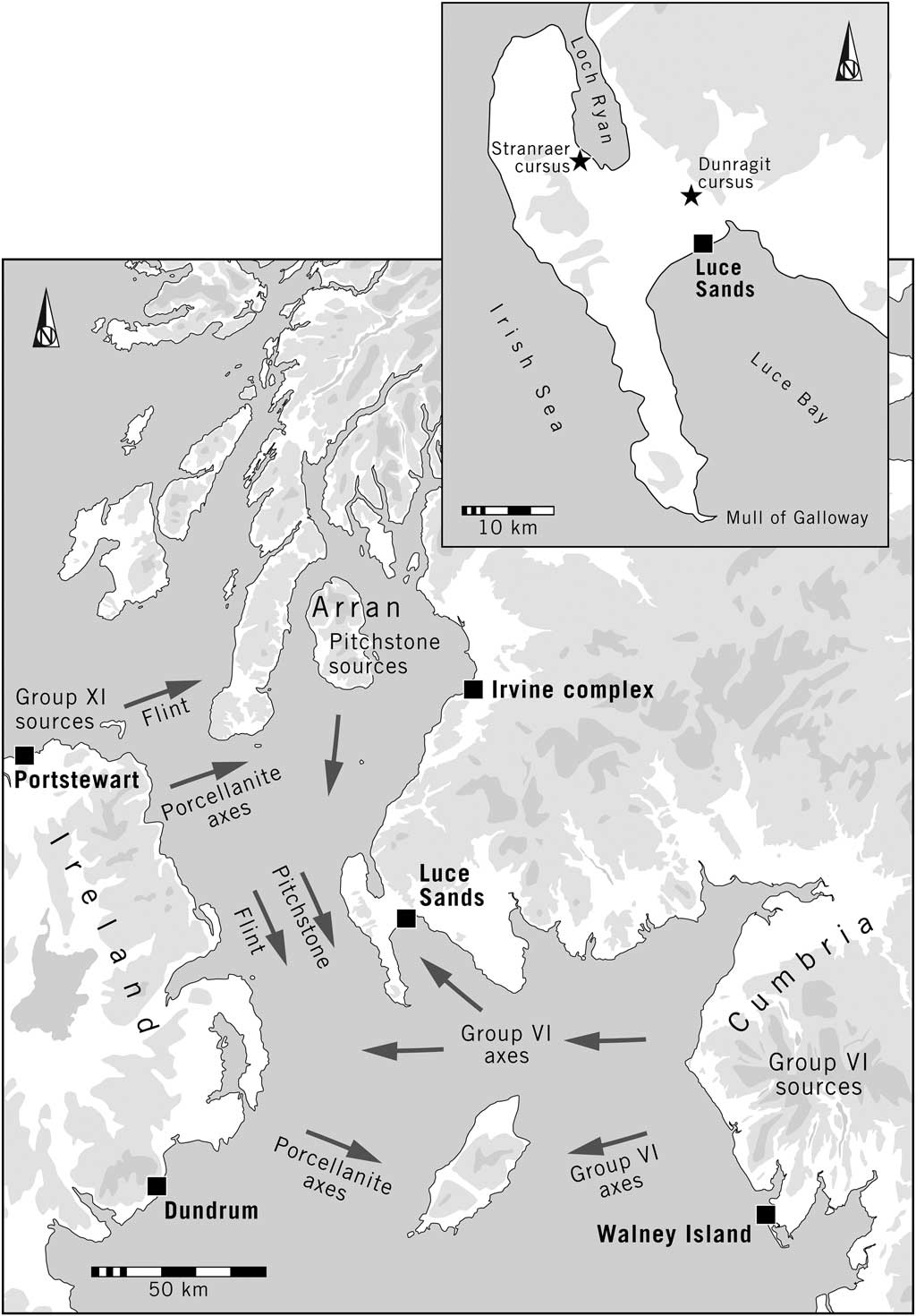
The museum collections include a few objects of exceptional character. The most obvious examples include two laurel leaves, an especially large leaf- or kite-shaped arrowhead, parts of four discoidal knives, six tanged or barbed and tanged arrowheads of unusual size, and the tip of a flint dagger (another possible example of this type is reported from the Sands). They also provide evidence for the use of non-local materials (Fig. 5). There is an exposure of silcrete at Lossiemouth, on the coast 25 km east of Culbin (Ballin Reference Ballin2014; Ballin & Faithfull Reference Ballin and Faithfull2014). There are also pieces of high quality flint that appear to have come from the mines at the Den of Boddam close to the North Sea more than 100 km away (Saville Reference Saville2008; Reference Saville2011). They can be found as large nodules, but are often of poor quality, cracked, and difficult to work. For that reason they are uncommon far from the source and better quality raw material may have been obtained from other deposits (Suddaby & Ballin Reference Suddaby and Ballin2011). Even more striking is the presence of chalk flint, finely worked into transverse arrowheads and other artefacts using the distinctive technology that typifies the Late Neolithic period. This material is believed to originate in Yorkshire – a distance of 550 km to the south (Ballin Reference Ballin2011). The same source accounts for some of the scale-flaked and plano-convex knives as well as the laurel leaves and a few of the barbed and tanged arrowheads. Pieces of Yorkshire flint were reworked at Culbin, suggesting that it was especially prized. Because of the circumstances in which the collections were formed there is no way of estimating the percentage of imported material – it varies between the principal museums – but its presence is remarkable. The same applies to a few fragments of Arran pitchstone which came from 240 km to the south-west. By contrast, there is little evidence of non-local axeheads, although the few fragments that can be recognised came from Cumbria, Perthshire, and Northern Ireland. There was nothing to suggest the use of exotic materials in the small collection recovered by fieldwalking.
The location of the Culbin Sands in relation to the principal sources of lithic raw materials found there

Other finds suggest that specialised artefacts were being made at Culbin, especially during the Chalcolithic and the Early Bronze Age. Their locations are rarely recorded accurately, but they include two stone moulds for making flat axes (Coles Reference Coles1969, 99; Schmidt & Burgess Reference Schmidt and Burgess1981, 53–4 & pl. 26). Axes of this kind are recorded from three separate locations, and there was also a hoard dating from the Migdale phase of the Early Bronze Age, between the 22nd and 20th centuries BC (Coles Reference Coles1969, 83). An Early Bronze Age halberd is recorded from the edge of the Culbin foreland (Coles Reference Coles1969, 87). Most of those finds form part of the distinctive concentration of early metalwork in north-east Scotland discussed by Needham (Reference Needham2004). In its initial stage it seems to have been based on Irish copper imported through the Great Glen.
There have been few finds of earlier prehistoric pottery, but sherds of Bell Beaker were discovered in the remains of a hearth containing burnt grain (Callander Reference Callander1911). At least three cremation burials are also recorded. One was accompanied by a Cordoned Urn and faience beads. This is of particular interest, as the same association is repeated on the opposite side of Findhorn Bay. Discussing these finds in Shepherd and Shepherd (Reference Shepherd and Shepherd2001), Sheridan and McDonald observe that the beads had probably been locally made. That is significant as they quote evidence for the later, Iron Age production of glass beads in the area occupied by the Sands.
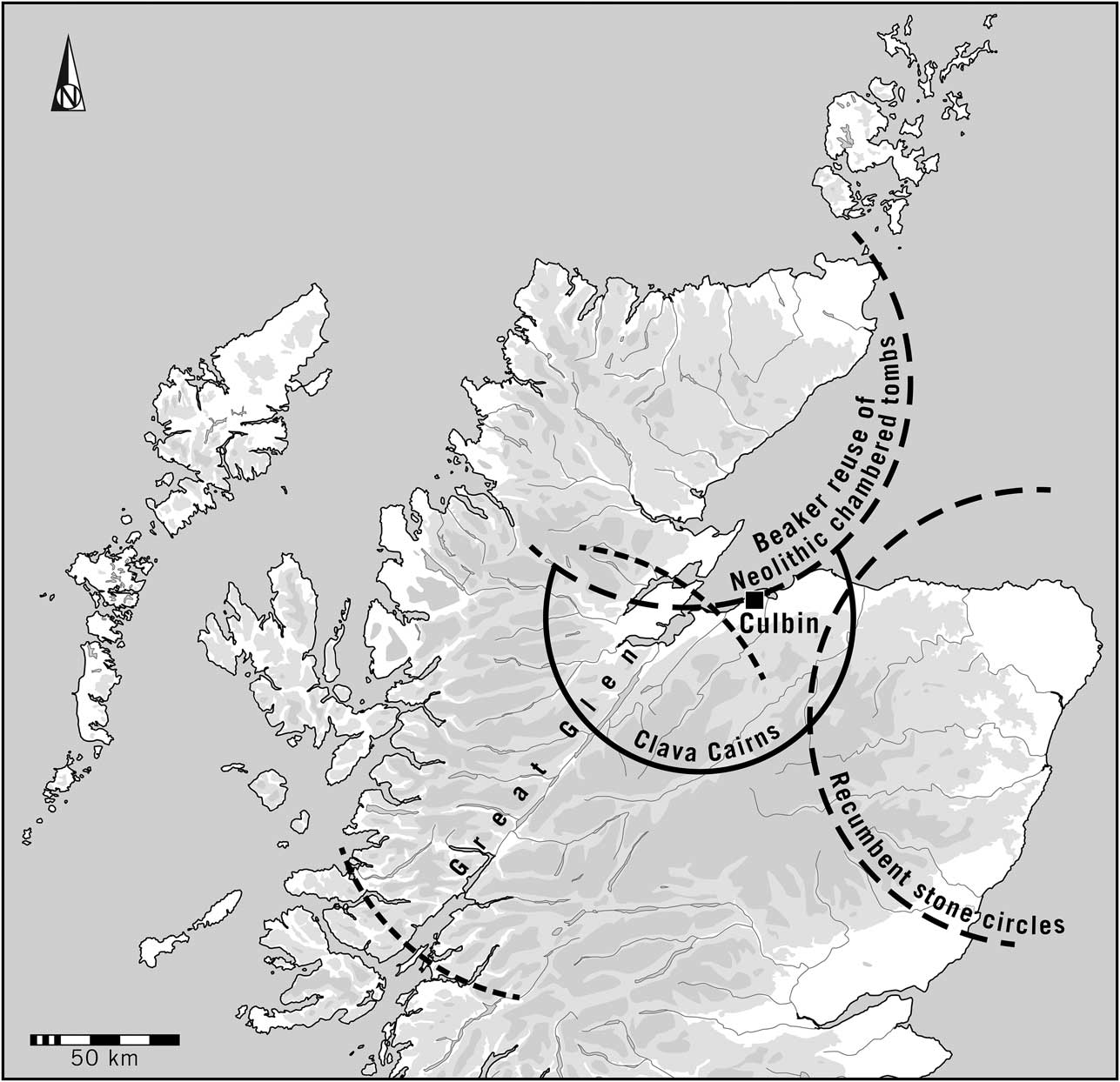
Perhaps the Culbin complex was in a boundary zone. Some years ago one of the writers suggested that the inner Moray Firth was the meeting place of several regions during the Chalcolithic and Early Bronze Age (Bradley Reference Bradley2000, 227–31). One was represented by the use of the Great Glen (Fig. 6). The distinguishing feature of another was the construction of Clava Cairns. Further to the north, Neolithic chambered tombs were reused at this time and were associated with Beaker pottery, while to the east, beyond the distribution of Clava ring cairns and passage graves, there were recumbent stone circles. Subsequent research has shown that these architectural traditions were used concurrently (Bradley Reference Bradley2005), yet the similarities and contrasts between them are so striking that each may have been an expression of local identity. Culbin was interpreted as an ‘aggregation site’ in the borderland between separate communities.
The pivotal position of Culbin in relation to the territorial scheme postulated by Bradley (Reference Bradley2000)

At the same time the Findhorn estuary possessed an exceptionally productive ecosystem and it would be wrong to suppose that this place played an entirely specialised role. The archaeological sequence began during the Mesolithic period when the coast must have provided an important source of food. There is no evidence that this changed during later phases. It would be more accurate to say that the Culbin foreland assumed additional roles from the Neolithic onwards. It is reflected by the exceptional number of earlier prehistoric artefacts found there, compared with the quantity from equally rich environments in the surrounding area. The main contrasts are in the intensity of activity as well as in its unusual characteristics.
Parallels for Culbin
(Richard Bradley, Diana Coles, Julie Gardiner, Alice Rogers & Fraser Sturt)
The same approach may be relevant to other coastal sites with exceptional concentrations of artefacts extending from the Neolithic to the Early Bronze Age. Two compare closely with the archaeology of Culbin. The first is another dune complex – the Luce Sands around Glenluce in Dumfries and Galloway – whilst a second is Hengistbury Head which was mentioned in the introduction to this article. Both share some characteristics with the Culbin complex, and, taken together, they offer clues to the interpretation of further collections from the shores of the North Sea and the Irish Sea.
The next section provides brief summaries of the Luce Sands and Hengistbury Head in the light of previous work. In each case substantial collections survive and have been examined at first hand. It is followed by a broader review of other locations which might have had a similar significance although the documentation is poorer. A final discussion draws this information together and reflects on the importance of long distance networks in earlier prehistoric Britain.
Some Examples
The Luce Sands (Diana Coles)
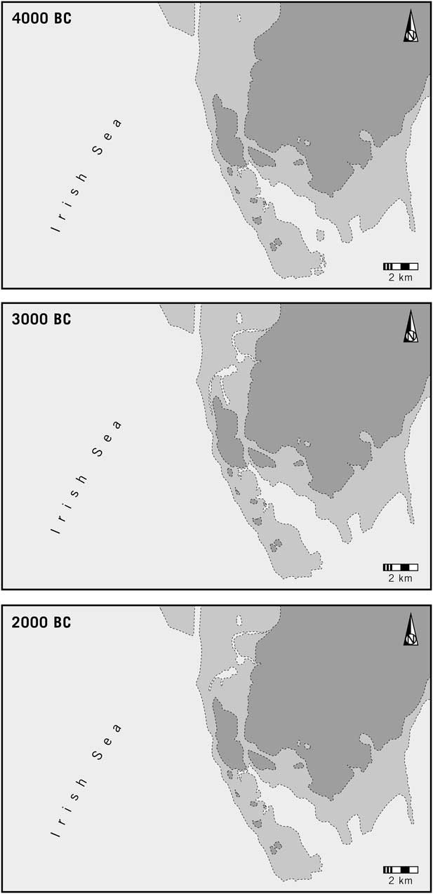
The Luce Sands are at the head of the westernmost bay on the north shore of the Solway Firth in south-west Scotland. They are located beside the narrow neck of land that provides access to Loch Ryan and the Irish Sea. They comprise a crescentic dune system on top of curved ridges of beach gravels containing a large number of flint pebbles and cobbles. To their north is a fossil cliff.
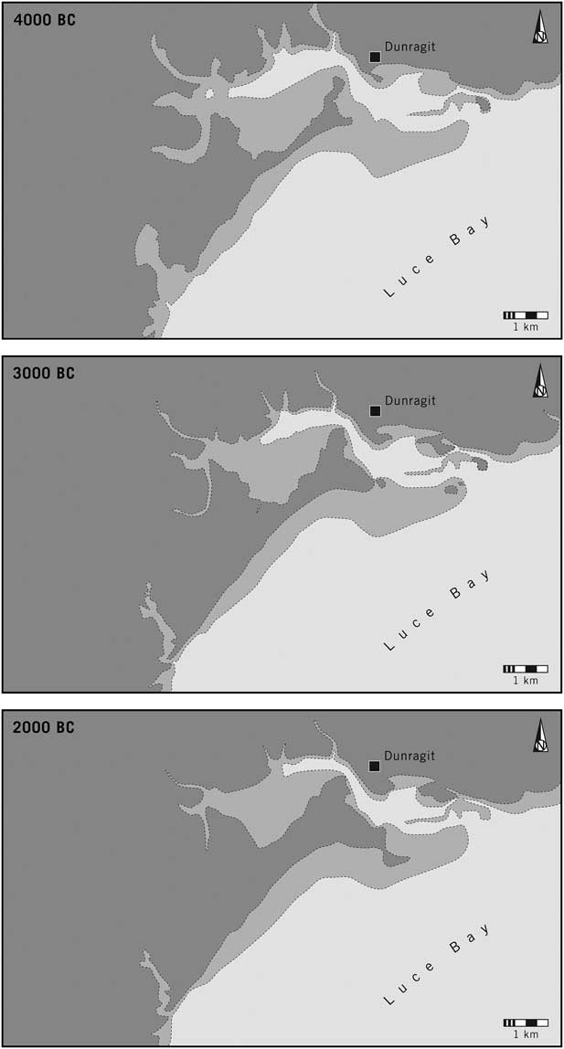
Many artefacts were collected on the Sands from the 19th century onwards (Wilson Reference Wilson1876; Reference Wilson1881; National Museum of Antiquities of Scotland 1892, 88–90; McInnes Reference McInnes1963), but the area has suffered from its use for military training (Cowie Reference Cowie1996; Coles et al. Reference Coles, Sheridan and Begg2011a; Reference Coles2011b). Formal excavation in 1977 showed that land surfaces still survived where artefacts remained in situ. Many were assigned to the Early and Middle Neolithic periods. They included a large collection of Impressed Ware. There was evidence of a buried soil beneath the later dunes, associated with pottery, large pieces of burnt pitchstone, and large, finely made knives and scrapers of Antrim flint (Cowie Reference Cowie1996). Another excavation took place in 1992 and produced lithics and pottery which included Carinated Bowl pottery, retouched flint artefacts, refitting debitage, an axe fragment reworked into a scraper, and a radiocarbon date of 3940–3700 cal bc; 5005±35bp; (SUERC-18657/Coles et al. Reference Coles, Sheridan and Begg2011a; Reference Coles2011b). There was also an excavation by Richard Atkinson, never published, but the pottery from his project was included in a general review of the finds from the sand dunes by Isla McInnes and covers every phase from the Early Neolithic to the Early Bronze Age (1963; cf. Callander Reference Callander1929, 63–7). The model of sea level change developed by Sturt et al. (Reference Sturt, Garrow and Bradley2013) indicates that most of these finds came from a coastal bar which would have sheltered a tidal inlet to its north. That remained the case between 4000 and 2000bc. The sand dunes expanded southwards as sea levels fell. It is possible that this process gained momentum after the Early Bronze Age (Fig. 7).
Outline reconstruction of the changing coastline of Luce Bay between 4000bc and 2000bc. Light shading indicates areas between 0 and 5 m above mean sea level. Higher ground is shown in dark tone. The main concentrations of finds, few of which are accurately provenanced, come from the bar. The maps indicate the position of the successive monuments at Dunragit. In this and the other reconstructions in Figures 8–13 the locations of the prehistoric finds are not recorded in sufficient detail to be mapped, although their general distributions are summarised in the text

The lithic assemblage from the Early and Middle Neolithic indicates a range of contacts along the Irish seaboard. Exotic material abounds (Coles Reference Coles2011a). The Luce Sands have produced the largest collection of Arran pitchstone anywhere in mainland Scotland (Ballin Reference Ballin2009, chap. 7). The high quality aphyric pitchstone was knapped on site to make narrow blades and bladelets, and many of the cores were completely worked down. Over 900 pieces of pitchstone have been examined, but less than half a dozen show secondary modification, although some information may have been lost due to natural ‘sand blasting’. Additionally, there is evidence for the introduction of Antrim flint across the sea. The pitchstone and some of the Irish flint appear to have been worked locally. Stone axes are also represented at these sites. There are more fragments than whole or damaged examples. Some were reused as cores and others were refashioned into scrapers and arrowheads. Most are of Group VI material imported from the Langdale Fells, but Luce Bay has also produced two jadetite axes originating in northern Italy and found in the Glenjorrie Burn (Murray Reference Murray1994; Pétrequin et al. Reference Pétrequin, Cassen, Gauthier, Klassen, Pailler and Sheridan2012, 712). Other finds included a Seamer axe and a discoidal knife, both of which may have originated in Yorkshire.
Locally available raw material was also important. It is clear that beach flint was extensively used, and may have been one of the determining factors in the selection of this location; larger pieces may have utilised flint introduced from Northern Ireland. The raw material collected on the shoreline was suitable for the manufacture of leaf-shaped arrowheads, of which an exceptional number (about 350) have been recovered. Some of them are unfinished. Experiments undertaken with John Lord suggest that heat treatment can be employed to make the local pebble flint workable (Coles Reference Coles2011b).
Use of the Sands during a later phase is evidenced by the presence of just over 40 transverse arrowheads of Late Neolithic type, only one of which was of the fine, ripple-flaked, oblique, variety. By contrast, there were around 150 barbed and tanged arrowheads, including a rare import from Ireland. There is also a quantity of Grooved Ware and Beaker pottery. Some of the Beaker vessels may have been associated with occupation sites among the dunes, but there is also evidence for a series of Early Bronze Age burials, including urned cremations (Wilson Reference Wilson1888; Davidson Reference Davidson1952; Cormack Reference Cormack1968). They were associated with cists, small cairns, and a circular enclosure. Among the artefacts found with human remains were a copper knife and faience beads. There was also a flat axe whose context is not recorded. Lastly, large pieces of unworked jet or jet-like material are known from the Luce Sands, but it is not clear whether they were introduced during the earlier prehistoric period.
It is probable that one of the attractions of Luce Bay was the presence of flint in the form of beach pebbles which were exploited from the Late Mesolithic period onwards. By the Middle Neolithic period it seems to have become a centre for the import of exotic materials and the manufacture of flint artefacts, in particular arrowheads. Not far from the main concentration of findspots was a timber cursus at Dunragit (Thomas Reference Thomas2015); a domestic structure associated with a leaf-shaped arrowhead has recently been found nearby (Guard Archaeology 2015). The area retained its importance in the Late Neolithic period when a large palisaded enclosure was built at Dunragit (Thomas Reference Thomas2015). Two exceptionally rich Early Bronze Age burials have been discovered close to that site during road building (Guard Archaeology 2015).
Hengistbury Head (Julie Gardiner)
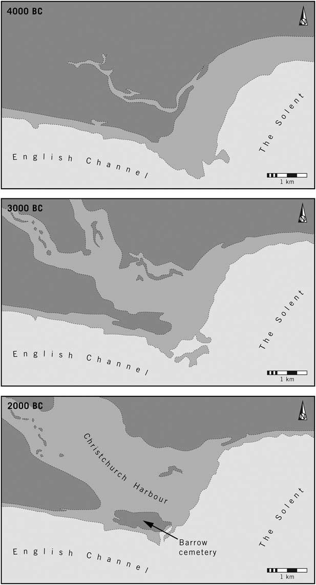
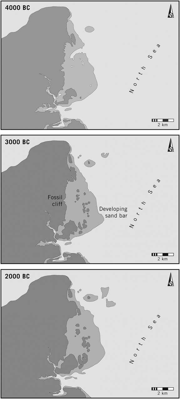
Again the coastline experienced significant changes between 4000 and 2000bc, but here the sea encroached on the land. At the beginning of the Neolithic period Hengistbury was a river mouth with an insubstantial bar, but by 3000bc the present position of Christchurch Harbour had emerged as an intertidal zone, sheltered by the high ground to its south. It was after this had happened that many artefacts were deposited there. By 2000bc the extent of the wetland increased and the prominent headland with its barrow cemetery was separated from the surrounding area (Fig. 8; Gardiner Reference Gardiner1987).
Outline reconstruction of the coastline at Hengistbury Head between 4000bc and 2000bc. Light shading indicates areas between 0 and 5 m above mean sea level. Higher ground is shown in dark tone. The main concentrations of findspots were to the south of Christchurch Harbour which developed during the period shown in this illustration. Only the positions of the Early Bronze Age barrows can be mapped accurately

Although there were Upper Palaeolithic and Mesolithic occupation sites at Hengistbury, this section is concerned with its use during the Neolithic, Chalcolithic, and Early Bronze Age periods. As was the case with the Culbin and Luce Sands, more artefacts are known to have been recovered than can be studied today (Gardiner Reference Gardiner1987). Some were recorded during early 20th century excavations of the late prehistoric port, but many have since been lost. Nevertheless sufficient is known to indicate a major concentration of ceramics and flint artefacts extending across much of the headland, including the location of the round barrows, but the main concentrations were on the high ground and towards the shore of Christchurch Harbour. Their distribution clearly extended further to the west, beyond the limits of the Iron Age defensive earthworks. Numerous artefacts were recovered by flint collectors in the earlier 20th century, predominantly on the northern (harbour) side of the isthmus. On the opposite site of that harbour was an unusual Late Neolithic midden associated with finds of Grooved Ware, with other notable Grooved Ware assemblages occurring to the north (Gardiner Reference Gardiner1987).
The pottery from Hengistbury dates from three main periods, and consists of sherds of Impressed Ware and Grooved Ware which came from the same areas as the other artefacts, and a series of Early Bronze Age vessels associated with barrows in the cemetery that extended across the higher ground of the headland; another barrow situated on low ground close to the present harbour shore contained a cremated female accompanied by a copper and amber halberd pendant, two gold cones, and amber beads. There was also a single find of a flat axe from one of the barrows (Gardiner Reference Gardiner1987).
Lithic artefacts dominate the material available for study today. There is only a limited quantity of debitage, but the retouched pieces of Neolithic, Chalcolithic, and Early Bronze Age date are notable for their exceptional quantity, their wide distribution, and especially for the fine quality of workmanship which distinguishes them from many other collections in Wessex. Two thousand finished artefacts have been examined, 80% of which were made from locally available nodules. Another 13% are composed of chalk flint very similar to that in Cranborne Chase where finds of similar character are abundant (although other sources are possible). The best indication of the changing intensity of activity is provided by the arrowheads. Twenty-four per cent are leaf-shaped and should date from the earlier part of the Neolithic period, but another 48% probably date from the Late Neolithic phase. Of these, 16% were chisel-shaped transverse arrowheads, and 32% were of the oblique variety which is often found with Grooved Ware; some of them showed the distinctive ripple flaking associated with the best executed examples of this form. Barbed and tanged arrowheads are less frequent but were used in the surrounding area at a time when the representation of these distinctive artefacts may have diminished on the chalk further to the north (Barrett et al. Reference Barrett, Bradley and Green1991, fig. 4.2).
The material available for study includes a few notable items: an ogival and a kite-shaped arrowhead; eight plano-convex knives; a polished discoidal knife; two Levallois-type cores suitable for making knives or transverse arrowheads; nine polished axes, two flake axes and a roughout; and a stone battle axe from an uncertain context. At a broader geographical scale there is evidence for the ‘clustering of elaborate or attractive objects around Hengistbury Head’ (Barrett et al. Reference Barrett, Bradley and Green1991, 69). This is evident from the research of David Field (Reference Field2008) who has recorded examples of ground stone axes, Seamer axes, and flint daggers in this area. There is also evidence for the working of Portland chert.
The collection from Hengistbury Head is unparalleled on the coast of Wessex and shares features in common with the material from major monuments in the hinterland, in particular the henges that have been investigated in recent years. Those in Cranborne Chase, south Dorset, and the Avon Valley would have been accessible from the river mouth at Christchurch Harbour, but in some respects the fine quality of the lithic artefacts from Hengistbury distinguishes them from the finds from those monuments. It also contrasts with most of the material recovered by fieldwalking on the chalk. The barrows on the headland play a part in the Channel Bronze Age (Needham Reference Needham2009; Needham et al. Reference Needham, Parfitt and Varndell2006). The evidence summarised here suggests that the river mouth was equally significant during the Late Neolithic period.
Related Sites
(Richard Bradley, Alice Rogers, Fraser Sturt & Aaron Watson)
The three complexes considered so far share certain features. Each is associated with an offshore island, promontory, or bar which protects an expanse of still water. They are accessible by sea and by land, and in every case they command points of entry to a wider region. They are located in unusually productive ecosystems and had been settled since the Mesolithic period when their wild resources would have been their principal attraction (Lacaille Reference Lacaille1944). At the same time in their later phases they are associated with unusually large assemblages which can include non-local artefacts and raw materials, as well as evidence of craft production. Their chronologies are not the same. The evidence from the Luce Sands is predominantly earlier Neolithic, most of the material from Hengistbury Head is Late Neolithic, while the bulk of the Culbin collection is even later in date. It is their topography that identifies these places as a group rather than their individual histories.
For that reason it is important to take a critical approach to other potential candidates. It would be misleading simply to focus on large collections of artefacts from the shoreline – still less those associated with dunes. In fact such assemblages are uncommon. The first stage is to identify places with similar physical characteristics to those already considered. They should include sheltered harbours or river mouths where it would be possible to moor boats away from strong currents or winds. It follows that two conditions must be fulfilled. Those places will be in the area of isostatic uplift where the ancient shoreline still survives. It means that the evidence will be confined to the Scottish coastline and to parts of northern England. At the same time, it is vital that any assessment based on modern topography is supported by a reconstruction of changing sea levels between about 4000 and 2000bc. In this article they are calculated in 5 m bands and mapped at thousand year intervals; the method is described by Sturt et al. (Reference Sturt, Garrow and Bradley2013). This procedure is followed to establish whether or not coastal bars or inlets would have been present during the earlier prehistoric period; it is not intended to reconstruct the shoreline exactly. Only when suitable targets have been identified by this method can the archaeological record be considered. Where such approaches provide consistent results it is worth taking the discussion further, but it must be understood that other places may have fulfilled exactly the same roles. At present they lack sufficient evidence, in particular large numbers of artefacts.
The sites in question are at Littleferry (Highland, formerly Sutherland), Tentsmuir (Fife), Walney Island (Cumbria), and Irvine (North Ayrshire). Another possibility is the coastline between Gullane and Hedderwick (East Lothian), which includes the findspots at Archerfield and North Berwick. In the following review the coastal sites in East Lothian are treated separately.
Some of these collections have already been compared with one another. In 1933 Callander likened the artefacts from the Culbin and Luce Sands to those from Irvine. Early accounts anticipate the interpretation suggested in this paper. Marjorie Cross described Walney Island as ‘one of the first ports of call for the coastal traders of the Highland Zone when the sea offered the easiest means of communication’ (1938, 161). In the same way, the Stevenston Sands, which form part of the Irvine complex, were characterised as ‘one of the greatest emporiums (sic) in the west of Scotland’ (Callander Reference Callander1933, 30).
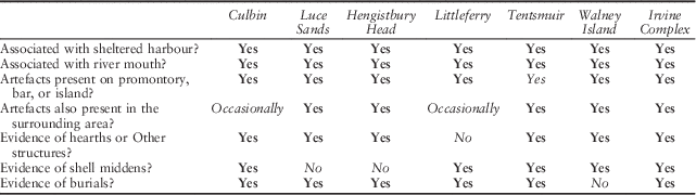
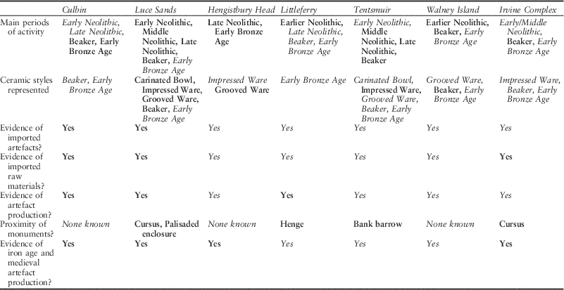
The characteristics of these sites are summarised in Tables 2 & 3, and the account that follows considers some of the features shared between them. The topographical evidence is presented first, followed by a more tentative review of the artefact record. In both tables the strongest evidence is indicated in bold. The account that follows quotes the principal published sources but also draws on entries in Canmore (the online database of the Royal Commission on the Ancient and Historical Monuments of Scotland) and the Cumbria County Council Historic Environment Record.
Locational And Structural Features Shared By The Principal Sites

The strongest evidence is indicated in bold and more tentative observations in italics
The Chronological And Functional Associations Of The Principal Sites

The term ‘Earlier’ Neolithic is used where the chronology depends on lithic artefacts. ‘Early’, ‘Middle’, and ‘Late’ Neolithic refer to dates based on ceramics. ‘Early Bronze Age’ refers to individual pots, from food vessels to cordoned urns, which were usually associated with burials. The strongest evidence is indicated in bold and more tentative observations in italics
The topography of the findspots
The changing relationship between land and sea has been described and mapped for Culbin, Luce Bay, and Hengistbury Head. It is equally relevant to Littleferry, Tentsmuir, Walney Island, and the findspots around Irvine. The distinctive character of the coastal sites in East Lothian is considered in a later section. Again these reconstructions are based on changing sea levels, the nature of the modern shoreline, and submarine topography. They summarise the situation at 4000, 3000, and 2000bc.
The sequence at Littleferry is among the most straightforward (Fig. 9). By 4000bc there was a narrow island at the mouth of the River Fleet. Over the next two millennia it developed into a bar joined to the mainland to the north and sheltered the intertidal zone occupied by Loch Fleet. The best provenanced artefacts – leaf-shaped arrowheads, some of them unfinished – come from the bar.
Outline reconstruction of the coastline at Littleferry between 4000 bc and 2000 bc. Light shading indicates areas between 0 and 5 m above mean sea level. Higher ground is shown in dark tone. The main concentration of findspots dates from the earlier Neolithic period and was located on the island at the mouth of the estuary

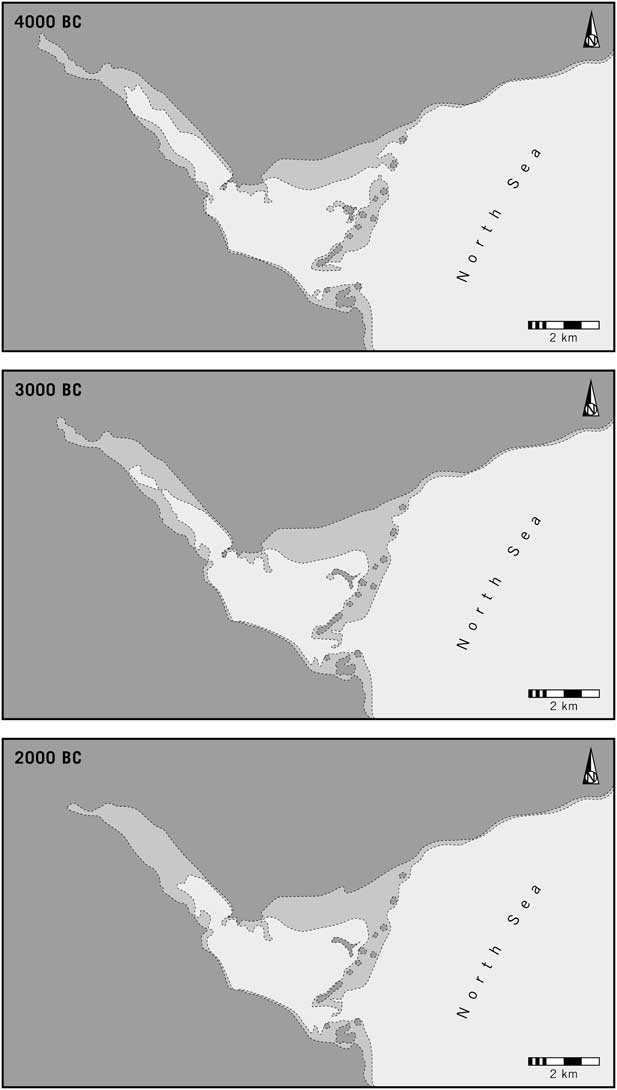
In some respects the sequence at Tentsmuir was like that in Luce Bay where sand dunes extended outwards from a fossil cliff line, but here the local environment underwent more changes (Fig. 10; May & Hansom Reference May and Hansom2003, 407–13). The main density of recorded findspots focuses on a zone less than 5 m above mean sea level, some of which would have been covered at high tide. To the south it contained a large island associated with earlier prehistoric artefacts and to the north there was a promontory and a shallow estuary. By 3000BC further islands had emerged and a bay developed in between two headlands. In effect there was a coastal bar which provided shelter from exposed conditions in the North Sea; that process was still more evident a thousand years later. The inner part of the bay (where low-lying farmland is vulnerable to floods even today) was probably entered from the north. Few of the artefacts from Tentsmuir are accurately located, but those that are provenanced come from promontories or islands that have been masked by later sediments (Paul Reference Paul1905; Longworth et al. Reference Longworth, Candow and Henderson1967). The surface finds from the sand bar itself consist of Grooved Ware, Beaker, and Early Bronze Age pottery (Longworth et al. Reference Longworth, Candow and Henderson1967; Cowie Reference Cowie1993).
Outline reconstruction of the coastline at Tentsmuir between 4000bc and 2000bc. Light shading indicates areas between 0 and 5 m above mean sea level. Higher ground is shown in dark tone. Few of the finds are accurately provenanced, but they are recorded from the former shoreline (now a considerable distance inland) and from the block of higher ground beside the estuary towards the south of the map. They also come from the isolated areas more than 5 m above mean sea level – apparently an emerging sand bar – which ran parallel to the North Sea. A fossil cliff distinguished the permanently dry land to the west from an intertidal zone to the east

The earlier prehistoric topography of Walney Island is harder to appreciate since its surroundings have been altered by the development of Barrow in Furness. Around 4000 bc there was one major island which was accessible from an estuary to the south and probably from an intertidal inlet to its north. Between 4000 and 3000 bc sea channels developed in the latter area. There were few changes by 2000 bc, but at some stage the main island was linked to others, probably by blown sand (Fig. 11; May & Hansom Reference May and Hansom2003, 443–5). The best documented artefacts come from the parts of Walney which incorporated the positions of smaller islands, but the important collection from its northern tip came from an area less than 5 m above mean sea level (Cross Reference Cross1938; Reference Cross1939; Reference Cross1942; Reference Cross1946; Reference Cross1947; Reference Cross1949; Reference Cross1950; Barnes Reference Barnes1955; Barnes & Hobbs Reference Barnes and Hobbs1950; Evans Reference Evans2008, 121–4). There is evidence that it was once dry land as surface observation identified a buried soil beneath one of the dunes and traces of a former beach line. The Walney complex was situated between the ends of two estuaries and divided from the mainland by a narrow channel. It was easily accessible from the north, but there were exposed rocks in the sea to its south.
Outline reconstruction of the coastline at Walney Island between 4000bc and 2000bc. Light shading indicates areas between 0 and 5 m above mean sea level. Higher ground is shown in dark tone. Few of the finds are accurately provenanced, but they are recorded from the higher ground, particularly towards the northern limit of the modern island

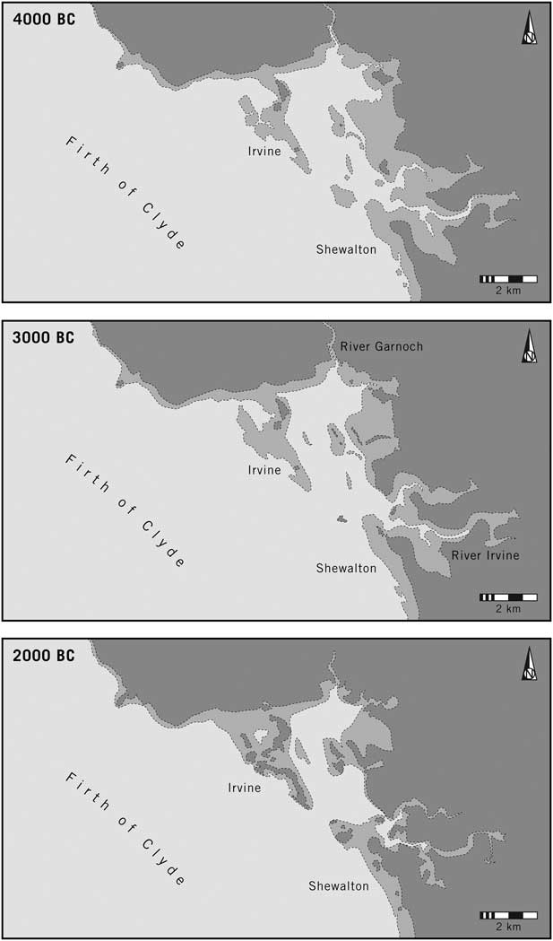
Like Walney Island, the topography of the Irvine complex has been changed by modern development, but during the earlier prehistoric period its character is obvious. It includes the assemblages from Irvine and those from Shewalton (Smith Reference Smith1895, 29–55 & 85–7; Lacaille Reference Lacaille1930; Callander Reference Callander1933). There is evidence of prehistoric activity between the mouths of two rivers, the Garnoch and the Irvine. By 4000bc the exit of the Garnoch was protected by a bar, with a sheltered harbour to its east, whilst the Irvine entered an intertidal zone bounded by small islands. Together they defined the limits of a shallow bay. By 3000bc the bar had become more pronounced, and a millennium later it had increased in size again. Another promontory developed at Shewalton. The bay remained a major feature of the coastline (Fig. 12). Its northern limit was the spit which produced the main collection of prehistoric artefacts on the Stevenston/Ardeer Sands at Irvine. At Shewalton towards its southern limit was a less precisely located group of finds. Both would have been located on the edges of a natural haven protected from the Firth of Clyde.
Outline reconstruction of the coastline around Irvine between 4000bc and 2000bc. Light shading indicates areas between 0 and 5 m above mean sea level. Higher ground is shown in dark tone. Few of the finds are accurately provenanced, but the places with the main concentrations are shown

Among the sites considered so far are four where concentrations of artefacts were found with structural evidence, although it was seldom recorded in detail (Table 2). These features included hearths defined by rings of boulders, pits, or ‘hollowed shelters’, and areas of stake-holes. In most cases they cannot be dated, but two large hollows identified in excavation on the Luce Sands were Neolithic (Cowie Reference Cowie1996). Unfortunately, the ard furrows recorded during the same project cannot be assigned to any period. Even so, they suggest that people lived there, as they had done since the Mesolithic phase – these were exceptionally productive environments. The Early Bronze Age saw a new development, for now the dead were buried by the sea. It happened in six cases out of seven. Most of the deposits seem to have been urned cremations. There are records of cists, and cairns have been identified in the Luce Sands (Davidson Reference Davidson1952; Cormack Reference Cormack1968). Hengistbury Head – the one southern English site considered here – includes a barrow cemetery (Gardiner Reference Gardiner1987). This may be related to a new emphasis on coastal sites as Chalcolithic and Early Bronze Age cemeteries.
Hengistbury conforms to a more general pattern, for the concentration of earlier prehistoric artefacts on the headland extends to the area around Christchurch Harbour and the lower reaches of the rivers that extend inland (Gardiner Reference Gardiner1987). They include some exceptional objects, a number of which were imported from distant regions. A similar pattern can be identified at four other complexes, whose associations are summarised in Table 3. Perhaps the clearest example is the remarkable concentration of Group VI axes around Walney Island in south-west Cumbria (Evans Reference Evans2008, chap. 9). Similar foci can be suggested near the coastal sites at Luce Bay, Tentsmuir, and Irvine, but not at Culbin or Littleferry.
Associations and activities
Not all these areas were used simultaneously (Table 3). Their topographical settings have much more in common than their chronologies. Much depends on the kinds of material found there, as lithic artefacts can be dated with less precision than pottery. Six complexes out of seven show signs of Mesolithic activity, which was most intense on Hengistbury Head in the south and at Tentsmuir and Irvine in the north. The Luce Sands, Walney Island, and Littleferry were important in the Early and Middle Neolithic periods, and there is more evidence of Late Neolithic activity at Tentsmuir and Hengistbury Head where there were harbours at the time. During the Chalcolithic phase it seems that Culbin, Walney Island, and the sites around Irvine played a significant role, but it was in the Early Bronze Age that all but one of these complexes included burials, although this is not to suggest that such places need have assumed a more restricted role. As Table 3 makes clear, in most cases activity may have been long-lived, but it could have been more intensive during some periods than others. Only at Walney Island might there have been intervals in which places went out of use. During every phase people may have been drawn to the coast because it offered an exceptional range of natural resources. At the same time it is seems as if these particular locations took on additional roles.
The Culbin and Luce Sands provide the most convincing evidence for the use of imported objects and raw materials. Direct evidence of non-local flint also comes from the Irvine complex where it had probably been introduced from Northern Ireland (Callander Reference Callander1933). The same has been claimed at Walney Island but the evidence is less secure, although hollow scrapers of Irish type have been found there (Evans Reference Evans2008, 8–9). Arran pitchstone is a feature of four locations on the coast. It is common at Luce Bay but is recorded in smaller quantities at Irvine, Tentsmuir, and Culbin (Ballin Reference Ballin2009, appx 1); it is more frequent among the unexcavated material from Blackpark Plantation on the island of Bute 30 km to the north-west of Irvine (Ballin et al. Reference Ballin, Barrowman and Faithfull2008). Flint attributed to sources in Yorkshire is known from Tentsmuir, Culbin, and Littleferry. A cache of decorticated flakes is recorded from the Stevenston Sands near Irvine and recalls a similar collection from the southern tip of the Kintyre peninsula which may have been introduced, already worked, from Ireland (Saville Reference Saville1999).
Finished objects were imported to all the sites. Cumbrian axes have been found in quantity on the Luce Sands and on and around Walney Island, and there are finds of Northern Irish axes from Shewalton in the Irvine group. Others were moved over greater distances and fragments of axes from the Lake District appear at Culbin and Littleferry. More distant sources are represented by the two jadetite axes in the Luce Bay complex and by another found close to Littleferry. Similarly, early copper and bronze axes, the first of them made from Irish ores, have been recorded not only from Culbin but at, or close to, Luce Bay, Irvine, Tentsmuir, and Littleferry.
There is less evidence of artefact production. A concentration of Group VI axe roughouts around Walney suggests that unfinished artefacts were brought from Scafell Pike and Great Langdale to be ground and polished on the coast; the sea is readily accessible from both stone sources, but by separate routes along inland valleys (Bradley & Edmonds Reference Bradley and Edmonds1993, chap. 7). Others were made from boulders collected on the seashore; there are several candidates from Culbin and a polissoir is recorded from the Stevenston Sands near to Irvine (Callander Reference Callander1933, 27). Between the Neolithic and the Early Bronze Age large numbers of arrowheads were produced at the Luce Sands, Culbin, and Littleferry (National Museum of Antiquities of Scotland 1892, 95; Coles Reference Coles2011b). It is possible that the axe hammers formed out of beach cobbles in south-west Scotland originated from Luce Bay (Fenton Reference Fenton1984). Other artefacts were made in these places. As mentioned earlier, Culbin is associated with the moulds for copper or copper-alloy axes, and faience beads were produced there during the Early Bronze Age. It may be no coincidence that all seven sites were involved in artefact production – especially the working of metals, glass, or jet – during later periods.
How were these complexes related to the monuments of the same phases? We might expect that large numbers of artefacts would be associated with these structures, but there is nothing to suggest it. There is some evidence from the Early or Middle Neolithic period. At Dunragit about 2.5 km from the nearest concentration of finds on the Luce Sands there was a timber cursus (Thomas Reference Thomas2015). Much the same association has been recognised at two more sites (Brophy Reference Brophy1999). A ditched cursus has been identified beside the River Irvine which discharges into the Irish Sea in an area with many finds of earlier prehistoric artefacts 5 km to the west. There may have been a bank barrow at Kilmany 5 km west of the former shoreline at Tentsmuir. Linear monuments of these kinds may have been built at the time when Impressed Ware was used on the coast. Other monuments are uncommon, but beyond the northern limit of the inlet at Littleferry is a small group of chambered cairns (Phillips Reference Phillips2002, 103–7). They are associated with another river valley (Strathfleet), but even the nearest of these structures was 5 km from the concentration of Neolithic finds.
The relationship between monuments and maritime havens was similar during the Late Neolithic period. The remarkable collection from Hengistbury Head has been compared with the material associated with henges in Wessex, but those sites were a long way from the sea, although they were linked to the coast by rivers (Gardiner Reference Gardiner1987). It was at this time that Christchurch Harbour assumed more or less its present form. To some extent the same relationship can be recognised in northern Britain. The only large monuments near one of the coastal sites are the Late Neolithic palisaded enclosure at Dunragit and the large round mound of Droughdoul which were separated from the main group of finds by a tidal inlet (Thomas Reference Thomas2015). Despite recent excavations which have recovered Mesolithic finds and Early Bronze Age burials (Guard Archaeology 2015), there are fewer records of Neolithic artefacts close to this enclosure than there are at the shoreline. The Dunragit complex includes at least one small henge, and another has been identified from the air near to Littleferry. Again it is some distance inland, beyond the limit of Loch Fleet and 3 km from the Neolithic findspots.
A coastal complex on the Firth of Forth?
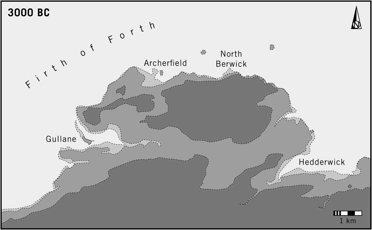
Four sites in East Lothian share similar characteristics, but in this case they are located on the same stretch of coast between Gullane and Hedderwick where the Firth of Forth enters the North Sea: a distance of 18 km. All these places are associated with dunes (Fig. 13).
Outline reconstruction of the coastline of East Lothian in 3000bc. Other maps are not provided, as the shore remained virtually unchanged during the periods studied in this paper. Light shading indicates areas between 0 and 5 m above mean sea level. Higher ground is shown in dark tone. The four locations with significant concentrations of earlier prehistoric artefacts are indicated

In each case the main groups of finds are associated with deposits of sand that follow the Firth of Forth. Their contexts are clearly documented at Archerfield (Curle Reference Curle1908), North Berwick (Cree Reference Cree1908), and Hedderwick (Callander Reference Callander1929, 67–72), but the record for Gullane Links is less informative (Richardson & Richardson Reference Richardson and Richardson1902; Lacaille Reference Lacaille1954, 275 & 278). In contrast to some of the places considered earlier, it is not clear how far these foci formed part of a wider distribution. There are striking contrasts between the collections from these places. The material from Gullane includes a significant Mesolithic component and made particular use of a local raw material – jasper. By contrast, the finds from Hedderwick are mainly Neolithic and Chalcolithic. Those from Archerfield and North Berwick are dominated by Beaker pottery. The four complexes may not have been used concurrently or in quite the same ways. It is their relationship to the Firth of Forth that identifies them as a group.
Studies of the earlier prehistoric coastline show that by 4000BC three of these places – Gullane, Archerfield, and Hedderwick – were associated with important inlets. There was little change between then and 2000bc. There seems to have been a small harbour at Archerfield, and at Aberlady Bay (Gullane) and Hedderwick there were major estuaries, but it was only at the last site that the distribution of finds is closely related to these features. Other sections of the shoreline are associated with rocky outcrops and cliffs and would not have been attractive places for strangers to land a boat. By contrast, Hedderwick is on the shore of a sheltered bay and protected by shallow spits or bars. The site that produced the earlier prehistoric artefacts is beside a watercourse that provides access to inland areas.
There is little structural evidence from any of these sites, but at Archerfield and North Berwick decorated pottery was associated with a series of shell middens containing animal bones (Cree Reference Cree1908; Curle Reference Curle1908). Other middens have been noted at Gullane but are not documented in detail. There were also cairns at Gullane, and individual cists are recorded beside the coast (Richardson & Richardson Reference Richardson and Richardson1902). All these places featured concentrations of artefacts similar to those described earlier, and again it seems as though activity extended from the Mesolithic period to the Early Bronze Age. Most of the ceramics are Impressed Ware, Grooved Ware, and Bell Beakers. Among the most diagnostic artefacts were barbed and tanged arrowheads. Axes of non-local material are recorded from Gullane and Hedderwick. The latter site produced a concentration of these artefacts, two of them from Cumbria, leaf-shaped and oblique arrowheads of Yorkshire flint, and a small amount of pitchstone. Chalk flint was also found at Archerfield and North Berwick.
In most respects the collections resemble those from the sites listed in Tables 2 and 3, but two features call for comment. A possible cursus and related monuments have been identified at White Kirk 4.5 km from Hedderwick (Lelong & MacGregor Reference Lelong and MacGregor2007, 209–11), but they are in a different part of the landscape from the findspots on the coast. Henges, on the other hand, have not been observed, even though Grooved Ware and Beakers feature at sites beside the Firth of Forth.
A second observation concerns the ceramic record. There are an exceptional number of decorated vessels among the Beaker pottery from Archerfield and North Berwick (Cree Reference Cree1908; Curle Reference Curle1908). Such an assemblage would be more appropriate in a cemetery, but no trace of any grave was found there. Animal bones and even fish bones survived, suggesting that the absence of human remains is significant.
The wider implications of these discoveries are considered in the final section of the paper.
Discussion
(Richard Bradley)
These ideas did not have a single source and it took a long time for them to be brought together. Some were influenced by the results of other projects, whilst others were suggested by developments in historical archaeology.
A starting point for this study was provided by two surveys in the inner Moray Firth, undertaken more than fifteen years ago. One was conducted close to the Clava Cairns (Bradley Reference Bradley2000, chap. 9), and the other on the Black Isle (Phillips Reference Phillips2002, 270–94), but each had the same objective of relating the distribution of surface finds to that of chambered tombs. With the exception of a few Mesolithic concentrations, earlier prehistoric artefacts were lightly scattered over the most fertile soils. Thirty km further to the east, however, the situation was different for an enormous collection of material of the same date was known from the Culbin Sands. Historical archaeologists had already recognised the anomalous character of the early medieval finds from the dunes and interpreted them as evidence of a beach market (Carver Reference Carver1999, 57).
Subsequent developments were of two kinds. The first was the recognition that similar concentrations of Neolithic, Chalcolithic, and Early Bronze Age artefacts had been recorded from other sand dunes. During the 1930s they were compared directly with one another, but they have received little attention since then and discussions of ‘sandhills settlements’ have lost their momentum. For roughly eight decades some of the original findspots have been virtually out of reach.
During recent years historical archaeologists have revised their interpretations of specialised sites on the coast. An important stimulus was Richard Hodges’s book Dark Age Economics, the first edition of which identified a series of ‘ports of trade’ where an elite controlled access to prestige goods brought there by sea (Reference Hodges1982). These sites were directly linked to high status settlements in the hinterland. More recent research has questioned this view, suggesting that people living by the shore exercised greater autonomy and engaged in production and exchange on their own behalf as well as that of their neighbours (Loveluck Reference Loveluck2013, chap. 9; Loveluck & Tys Reference Loveluck and Tys2006).
Prehistorians have benefitted from this change of perspective. Even a Late Iron Age site such as Hengistbury Head has been difficult to relate to any wider social developments (Sharples Reference Sharples2010), and the relationship between ‘ports of trade’ or ‘gateway communities’ and major settlements proposed by Hodges for the 1st millennium ad could hardly be extended to earlier prehistoric Britain. However, two studies did document the anomalous character of the sites on the shoreline; both have been summarised here. In 1987 Julie Gardiner drew attention to the exceptional nature of the ceramics and lithic artefacts from Hengistbury Head, comparing them with the finds from henges on the chalk. More recently, Diana Coles (Reference Coles2008) analysed the artefacts from the Luce Sands, emphasising the quantity of imported artefacts and raw materials and arguing that arrowheads were made there. Despite the proximity of a large enclosure and a prominent mound at Dunragit, much of the activity at the Luce Sands pre-dated the use of these monuments.
In 2004 the similarities between the artefacts from Culbin, Luce Sands, and Littleferry were considered by David Clarke (Reference Clarke2004). He stressed the importance of collections from other dunes and questioned the view that objects occurred in such large numbers simply because they were easy to find in sand. A more basic question was why those dunes developed in the first place. In northern Britain they were often associated with river mouths where natural bars protected an area of still water.
There was a problem with these observations. Whilst the age of the artefacts was known, the same was not true of changes in the maritime environment. Geomorphologists had identified the processes involved and proposed a sequence of deposits, but these were seldom dated (May & Hansom Reference May and Hansom2003). The difficulty has been resolved by new work which provides a more detailed reconstruction of the coastline and relates it to an absolute chronology. That model provided the information required for a new interpretation of prehistoric finds from the shoreline. In this paper it is presented at 5 m intervals.
A result of these developments is to emphasise the significance of sites whose archaeology has been overlooked during recent years (Figs 14 & 15). These collections were remarkable for their quantity and diversity. It seems that they were the result of at least three different processes: settlement on the shoreline itself; the reception of imported objects and raw materials; and the production of a series of specialised artefacts. Such features are normally associated with monuments, but the coastal sites were offset from structures of this kind, even when they existed in the same regions. The islands and bars at Littleferry, Culbin, and Tentsmuir were also cut off from their surroundings, and this was particularly true of the Ardeer Peninsula at Irvine. It is why they provided suitable locations for strangers to transact with one another.
A: Modern sand dunes at Tentsmuir which are still expanding eastwards into the North Sea. B: The mouth of the River Irvine where it enters the Firth of Clyde. The island of Arran is visible on the horizon. C: The shoreline of the Moray Firth beside the modern sand bar at Culbin. Photographs: A and B: Richard Bradley; C: Aaron Watson

A: The most northerly dunes on Walney Island. The Lake District mountains are visible on the horizon. B: The estuary of the North Tyne viewed from the prehistoric site at Hedderwick. C: Channels in the intertidal zone at Aberlady Bay. D: The Isle of Man seen from one of the main areas of findspots on the Luce Sands. Photographs: A and D: Aaron Watson; B and C: Richard Bradley

It is clear that people travelled long distances by sea. Such connections extended from Orkney to the Channel coast, and sometimes they reached even further. The coastal locations described in this article must have played a part in the process, but there is nothing to tell how far individual boat crews travelled or whether particular commodities were carried in several stages. Here it is necessary to emphasise the special importance of the beach. This paper has identified a series of locations in northern Britain, but has discussed only one further to the south. That is surprising as a whole series of ‘landing places’ of Iron Age and early medieval dates have been identified there, including Sandtun (Gardiner et al. Reference Gardiner, Cross, Macpherson-Grant and Riddler2001), Green Island (Wilkes Reference Wilkes2007), Mount Batten (Cunliffe Reference Cunliffe1988), Bantham (Fox Reference Fox1955), and Meols (Griffiths Reference Griffiths2007). With the sole exception of Hengistbury Head, such sites did not contain much older material. This is very different from the evidence on the coast of northern Britain. An obvious explanation is that the largest collections of earlier prehistoric artefacts come from areas of isostatic uplift, but it overlooks an important point for it is the beaches that have been lost in lowland England rather than their entire hinterland. It follows that they must have provided the principal focus of activity. The distribution of distinctive artefacts may extend further, but it was the shoreline that was especially important. Its traces survive in the north where most of the discoveries were made, but in the south it is submerged.
The topographical evidence considered earlier suggests that the principal findspots were not only associated with the shore, they were by sheltered harbours where it would be possible to protect light craft from the elements. In some cases they could be drawn up on sandbanks or mudflats, or moored in shallow channels. It would be especially important if they were skin boats, and it is possible that the use of such places diminished with the adoption of plank-built vessels which would have been more robust (Clark Reference Clark2002; Van de Noort Reference Van de Noort2011). At the same time it could be wrong to overemphasise purely practical considerations. Among the places considered in this account were offshore islands which were less promising for permanent occupation. They might have been used intermittently, and in this case their main importance could be that they were neutral locations where travellers and local people might meet (Dening Reference Dening2004; Mack Reference Mack2011, chap. 5; Haour Reference Haour2013). The water’s edge was a liminal place perfectly suited to this purpose. Its marginal position could be why coastal sites were sometimes used as cemeteries during the Early Bronze Age.
Such sites share other characteristics. Not only do they provide evidence of long-distance travel, they may have played a particular role in the transmission of new ideas. That is suggested by their chronology. Although the distinctive bowls that characterise the beginning of the Neolithic are not particularly common, they are recorded at Tentsmuir (Cowie Reference Cowie1993), and especially on the Luce Sands (McInnes Reference McInnes1963). Here they were associated with Arran pitchstone which also occurs at Stevenston. Luce Bay is associated with Cumbrian axes and the Irvine complex with similar artefacts from Ireland (Callander Reference Callander1933).
During the Neolithic period maritime havens must have played a part in the movement of exotic objects and materials (Fig. 16). One axis linked the quarries in Cumbria to Walney Island, the Luce Sands, and the findspots around Irvine. Another connected the latter sites to the sources of Group XI porcellanite axeheads in the north of Ireland. Antrim flint and Arran pitchstone have also been found there and at Luce Bay (cf. Cummings Reference Cummings2002, 139–41). In most cases stone artefacts must have been transported by sea. That is clearly evidenced in the case of pitchstone and porcellanite, and it may have been the case with the axes from north-west England which could have been taken across the Solway Firth. Others were ground and polished in the lowlands around Walney Island before they were exported from north-west England (Bradley & Edmonds Reference Bradley and Edmonds1993, chap. 7). There is less variety among the assemblages along the North Sea, but Torben Ballin’s research suggests that Yorkshire flint was used by communities on the coast (2011). This implies the existence of an eastern axis which extended over a greater distance than the better known evidence from the Irish Sea (Ballin Reference Ballin2011). It seems to have been associated mainly with the use of Grooved Ware (Cleal & MacSween Reference Cleal and MacSween1999, chaps 5 & 6), but at Littleferry the debitage in this material may be rather older as there is no evidence for the use of Levallois technique. This observation is important as that method of working flint can also be found with Impressed Ware.
The main axes of exchange in the Irish Sea as illustrated by the collections from Walney Island, the Luce Sands, and the Irvine complex. An inset shows the possible portage between Luce Bay and Loch Ryan and the positions of the cursus monuments at Dunragit and Stranraer. Two sites of similar character in Northern Ireland are also shown

It was with the adoption of Bell Beakers that the special role played by coastal havens became even more apparent. This style of pottery is found at most of the sites considered in this paper, but the feature that stands out is that many of these vessels date from the beginning of the Copper Age. They include examples from seven of the sites considered here (Gibson Reference Gibson1982, 98–100, 170–2, 192–4, 213–14, 239, 246, 250 & 254). Something rather similar applies to the earliest metalwork from these places. Moulds for making flat axes were found at Culbin and finished examples of this type are recorded from three separate locations there. Early copper or bronze axes have been found at, or near four of the other sites. Stuart Needham (Reference Needham2004) has identified a long-distance axis which connected sources of Irish copper to finds of metalwork in Scotland where some of them were distributed along the North Sea.
Although the sample is limited by the accidents of discovery, the positions of these places raise other points of interest. Walney Island is accessible from the axe quarries in Cumbria, and the Irvine complex is directly opposite the source of pitchstone on Arran. All four sites in East Lothian are close to the entrance to the Firth of Forth. Perhaps it was where people crossed the water. The distinctive form of North Berwick Law can be recognised from the opposite shore and could have been employed as a seamark by people travelling down the east coast of Scotland. One clue is provided by excavation on the Isle of May which is in the middle of the estuary. Among the residual artefacts from a medieval ecclesiastical site were sherds of early Bell Beaker, a stone axe fragment, and pieces of Yorkshire flint (James et al. Reference James, Yeoman and Bain2008, 112–8). The island is visible from Hedderwick where it can be recognised on the horizon through the mouth of the estuary. Similarly, the Isle of Man is visible from Luce Bay and the northern approach to Walney Island is marked by a conspicuous mountain, Black Crag, where the Lake District mountains come down to the sea.
Another significant feature is the position of the Luce Sands. They were in the lee of a lengthy peninsula, the Mull of Galloway that separated this part of south-west Scotland from the Irish Sea. To navigate around it to the sheltered waters of Loch Ryan would have involved a journey of 75 km. By travelling overland the distance is reduced to 10 km. It is possible that people could have gone some of the way along a river, but it seems likely that otherwise their vessels would have to be manoeuvred across dry land. This is not a new idea, for over sixty years ago Sir Lindsay Scott suggested the existence of a portage here (1951, 31–2; cf. Noble Reference Noble2007). Since then a cursus has been found and excavated at Dunragit (Thomas Reference Thomas2015) and the site of another has been identified at Stranraer. They would have been by either end of this route (Fig. 16). One reason for the special importance of Luce Bay is that it is protected from strong winds by the high ground to its west. This would not apply to the estuaries further to the east.
Chronological considerations
This account has considered the period between the end of the Mesolithic and the Early Bronze Age. After that time there is less evidence for the use of these locations, but at some of the sites activity resumed during the pre-Roman and Roman Iron Ages and continued into the later 1st millennium ad. By then many other places seem to have been used in a similar way. How can this be explained?
The point has already been made that a larger part of the Iron Age and later shoreline is available for investigation, but that may not be the only reason. Another factor was a change in the nature of long distance communications. The sequence considered here started at the beginning of the Neolithic when there must have been connections between coastal regions of Britain, Ireland, and Continental Europe, but there is little to suggest that they were sustained throughout the later 4th and earlier 3rd millennia bc. From the adoption of Bell Beakers and the first metalwork links may have been re-established, especially with regions supplying gold, copper, and tin, but those contacts seem to have been between specific parts of these islands and particular parts of the mainland. Travel between them could still have been a special event (Van de Noort Reference Van de Noort2006). Voyages between maritime havens along the coast may have happened more often.
That could have changed towards the end of the Early Bronze Age, for this was the first time for two thousand years that there were striking similarities between settlements, enclosures, and items of material culture on both sides of the Channel and the southern North Sea. The discovery of roundhouses at settlements in northern France provides one example, and the earliest coaxial field systems appear in the same period in Normandy, Brittany, lowland England, and the Netherlands. Such evidence suggests the sharing of features between regions which had been largely independent before. The sea was no longer experienced as a barrier between separate landmasses. Now it acted as a link (Bradley et al. Reference Bradley, Haselgrove, Vander Linden and Webley2015, chaps 5 & 6).
It is no coincidence that the earliest plank built vessels in Britain are dated to the same period – the end of the Early Bronze Age and beginning of the Middle Bronze Age. There may have been an important change in the character of seagoing craft, with boats that were more robust and better suited to long distance voyages. This paper has suggested that a series of enclosed estuaries were ideal places for sheltering skin boats from the elements. That might have been less important with the use of more substantial vessels which could be beached in less hospitable environments – as undoubtedly happened during the historical period. Some of the places described in this account remained in use throughout the Bronze Age, but most of them may not have done so, for the character of seaborne travel had been transformed.
The possibilities for future work
It would be wrong to end this article with a dogmatic conclusion when there is scope for further work. Coastal sites in Ireland have not been considered here. There is little doubt that they existed and took a similar form, but at present the available material does not permit a similar analysis. The most promising candidate is Dundrum, the type site for the Middle Neolithic pottery that Humphrey Case called Sandhills Ware. Here traces of ephemeral structures were identified by excavation (Collins Reference Collins1952; Reference Collins1959). Another is the dune system at the mouth of the Bann close to Portstewart which was associated with exceptional quantities of pottery and lithic artefacts (Wilson & McGourty Reference Wilson and McGourty2002). Both share the characteristic topography of the British sites considered in this paper.
No attempt has been made to identify maritime havens in regions where the ancient coastline has been lost to the sea, yet promising candidates present themselves when artefacts of similar character appear in unusual numbers near the coast. They may be similar to the broader distributions of findspots around Walney Island and Hengistbury Head. They include Mounts Bay in Cornwall where evidence of stone axe production has been identified (Jones et al. Reference Jones, Lawson-Jones, Quinnell and Tyacke2013), and Merthyr Mawr in south Wales. It has already been interpreted as an Iron Age beach market (Lynch et al. Reference Lynch, Aldhouse-Green and Davies2000, 207), but includes a notable concentration of earlier prehistoric artefacts and burials (Savory Reference Savory1980; Burrow Reference Burrow2003, 250–3). All that is lacking is the ancient shoreline which is now submerged. A further possibility is found in East Sussex where a series of specialised sites towards the edge of the chalk downland were associated with the production of discoidal flint knives. They overlooked an inlet of the sea whose position is preserved by the Willingdon Levels (Gardiner Reference Gardiner2008). Other candidates can be suggested in parts of East Anglia where the earlier prehistoric coast is buried beneath later sediments. A paper published in 1999 considered the largest lithic scatters identified by the Fenland Survey (Edmonds et al. Reference Edmonds, Evans and Gibson1999). The finds from Soham and Ramsey were as varied and perhaps as long lived as the collections considered here. Since that analysis was published, more detailed study has shown that both these concentrations of artefacts were located at river mouths (Sturt Reference Sturt2006). It seems possible that these places provided sheltered havens similar to the other sites.
A final possibility is to locate new examples of this distinctive pattern. There may be cases in which prehistoric material still awaits discovery and can be investigated by targeted fieldwork rather than the combination of library and museum work which has formed the basis of this study. In that case the procedure followed here needs to be reversed so that a reconstruction of the earlier prehistoric coastline precedes other kinds of analysis. It can be used to suggest where ancient harbours might have existed in the past. Then they can be examined on the ground; a similar method has been employed in the archaeology of Gotland (Carlsson Reference Carlsson1999). It seems unlikely that the sample of poorly recorded finds that has been considered here provides the only evidence of a neglected but important phenomenon.
Acknowledgments
We must thank the farmers and landowners who made our fieldwork at Culbin possible, and Pat Scott for her hospitality. We are particularly grateful to Alison Sheridan for access to the artefacts from Culbin in the NMS, for organising visits to Gullane and Tentsmuir, and for much valuable discussion. The staff and volunteers at Elgin and Forres Museums were equally helpful. Here we benefitted from the work of Torben Ballin who had already catalogued the lithic artefacts; the analysis presented here is similar to his but is based on our own examination of the collections. He also provided extremely helpful comments on the text. Thanks are also due to Martin Carver, Robert Crawford, Shannon Fraser, and Duncan Garrow for their help and advice. Alex Gibson, Stuart Needham, and Alison Sheridan kindly read and commented on a previous draft of the text. Lastly, the other authors would like to acknowledge Aaron Watson for his excellent illustrations which made writing the paper much easier.