


‘There is no doubt that the most important factor ensuring the sovereignty of any nation or state is the possession of a distinct territory wherein the populace can pursue its interests in a regulated manner.’
Governor Luis Mier y Terán, 1885As Oaxaca joined the new federal republic of Mexico as a state in 1824, a new question related to its territorial sovereignty soon revealed itself. Simply stated, where exactly did the new state's borders lie? At first glance, the issue seemed uncomplicated. During the late colonial period, the Bourbons had streamlined New Spain's bureaucracy by dividing the viceroyalty into intendancies, including Oaxaca, each comprised of numerous municipios. When Oaxaca became a state, its officials hoped simply to reiterate these intendancy boundaries, transforming the territorial limits of frontier municipalities into Oaxaca's límites (boundaries) with other federations. The expectation was that municipal councils had marked their territorial margins reasonably accurately in colonial times and that, if not, they possessed historical titles providing detailed descriptions of village landholdings that would enable such an undertaking. Considering these factors, marking the precise location of the state's borders appeared to be a routine matter to bureaucrats just after independence.Footnote 1
Due largely to Mexico's – and consequently Oaxaca's – political instability, the task nevertheless proved difficult to carry out in practice. It was not until the second half of the nineteenth century, following the enactment of federal land laws in 1856, that a new generation of liberal leaders was able to devote serious attention to surveying and marking the boundary. These labours continued throughout the following decades, especially during the Porfiriato (1876–1911). Even so, the state's venture repeatedly met with frustration. After decades spent on the project, the arduous and contentious work of demarcating a boundary with Oaxaca's neighbouring states – Chiapas, Guerrero, Puebla and Veracruz – was only marginally completed by the time the 1910 revolution began.Footnote 2
A major complication involved a developing redefinition of state territoriality after independence. As Peter Sahlins explained in his examination of the Spanish–French border in the Pyrenees, royal authority was traditionally envisioned in terms of sovereignty over ‘subjects’ residing in municipalities as opposed to mere jurisdiction over a delimited territory.Footnote 3 This concept appears to have prevailed in New Spain, and Oaxaca's intendancy limits were never rigidly defined in terms of strict territoriality during the colony. As the federal system took hold after independence and the concept of private property evolved along with incipient capitalism, individual states began to redefine their administrative provinces in terms of bounded space. Just as importantly, officials began to imagine state territoriality as permanently demarcated, an assumption that tended to defy lived experience along Oaxaca's vast frontier.Footnote 4 In practice, the municipal boundaries that bureaucrats had hoped to reiterate as state borders proved difficult to specify. Officials did not often encounter established boundaries along the frontier; rather, they found seemingly ubiquitous conflict regarding límites – a macrocosm of contradictory, indefinite and amorphous boundaries that often provoked violent disagreement regarding their whereabouts. The entire frontier region seemed rife with boundary disputes that gave the impression of lawlessness along Oaxaca's periphery.
Building on Raymond Craib's observation that state formation in part involves efforts to ‘define, codify and naturalize space’, this article focuses on Oaxaca's contentious efforts to mark its territorial sovereignty – its state border – during the period 1856–1912.Footnote 5 The evidence suggests that, efforts to institute private land tenure in rural Mexico aside, officials hoped to demarcate a permanent state border as a way to delineate a peaceful ending to these on-going límites conflicts. By focusing on the state's various campaigns to outline its jurisdictional province on the ground, we can observe the social, political and practical aspects of the formalisation of state authority in rural Oaxaca. These efforts, which took place over the course of nearly six decades, also demonstrate how frontier citizens sought to reaccommodate or, in Kapil Raj's terms, ‘reposition’ themselves according to the newly defined parameters of centralising state power during the era.Footnote 6 As such, we might interpret Oaxaca's boundary marking as efforts to physically delineate the material and institutional parameters of state authority or, put another way, as a literal process of state formation, the results of which ironically demonstrate the state's inability to fortify its presence along its periphery in the decades prior to the revolution.
Internal Boundaries
Scholars from a variety of academic disciplines began paying serious attention to the historical and cultural construction of space by the 1980s.Footnote 7 Building on a long tradition of cartographic history, studies in spatial history have often focused on exploration, discovery and the dialogic production of space.Footnote 8 Recently, a burgeoning historiography owing much to the pioneering work of J. B. Harley has analysed the emergence of cartographic science as a critical tool of imperialism and nation building. Paying particular attention to the eighteenth and nineteenth centuries, these scholars generally view the historical production of maps and boundaries as processes embedded with interests related to statecraft.Footnote 9 Many of these studies focus on the role of cartography in asserting national distinctiveness and have stressed the significance of borders in generating a common sense of national history unfolding, often anachronistically, on a permanently ‘fixed’ historical stage.Footnote 10 Working from Thongchai's maxim, that ‘a map is a model for, not a model of, what it purport[s] to represent’, many scholars have focused their studies on the construction of national borders via the process of map-making.Footnote 11
In Mexico, national boundaries represented a serious and sensitive public issue, especially after the cession of roughly half the nation's territories to the United States in 1848. Arguably, the establishment of recognised national borders subsequently enabled the government to project a sense of its permanence on an otherwise chaotic political scenario. At the very least, the fabrication of maps featuring national borders evidenced the emergence of a visual culture that, as in other nations, worked to promote a collective sense of national identity among Mexicans.Footnote 12 By the turn of the twentieth century, a burgeoning geographic awareness contributed to a growing sense of common nationalism.
Scholars interested in cartography's relationship to state formation have paid less attention to the historical production of internal spaces within national boundaries. The existent scholarship in this area has nevertheless generated innovative analyses of topics ranging from the implementation of private property regimes to the extension of state authority into previously (at least partly) autonomous rural provinces.Footnote 13 Interestingly, the marking of individual states’ borders – either in Mexico or abroad – has rarely been explored in academic scholarship.Footnote 14 During the second half of the nineteenth century, almost all Mexican states – but especially Oaxaca, Veracruz, Puebla, Guerrero, Sonora, Tabasco, Chiapas, Tamaulipas and Nuevo León – made efforts to definitively formalise their jurisdictional boundaries. Bureaucrats in these states hoped to impose order on an otherwise confused reality along poorly defined state borders, where incessant conflictos por límites (boundary disputes) routinely disrupted everyday life and provided officials with both a metaphorical and a literal illustration of the limits of state power. By the late nineteenth century, liberal regimes intended to rectify this situation as a means of asserting governmental authority to overcome what they perceived as rural chaos. All told, surveying efforts aimed at rationalising rural property continued well into the twentieth century.Footnote 15
Official campaigns to survey, map and mark state and other internal boundaries in Oaxaca proved contentious. Whereas the construction of Mexico's national borders arguably promoted unity around a common historical narrative, the practice of delineating state borders threatened to divide citizens and enflame territorial disputes, some of which had reputedly existed since pre-Columbian times.Footnote 16 State officials nevertheless prioritised this activity between 1856 and 1912. They deemed it vital to rationalise the state's jurisdictional limits, seeing the implementation of defined boundaries as necessary in facilitating efficient government. In effect, Oaxaca officials believed that establishing a well-defined state boundary would translate to increased social and political order; clarifying internal boundaries would put an end to recurrent límites conflicts and enable officials literally to delineate the peace among frontier communities.Footnote 17
Despite these efforts, numerous boundary disputes existed along Oaxaca's periphery on the eve of the 1910 revolution. In fact, the incidence of reported border conflicts steadily increased throughout the nineteenth century, after officials began seriously to demarcate state boundaries.Footnote 18 This occurrence leads one to consider whether efforts to mark Oaxaca's borders after 1856 brought innumerable, previously existing territorial disputes into the state's ‘field of vision’, as most officials effectively concluded during the era, or whether the routines of marking definitive boundaries actually created altogether new disputes.Footnote 19
‘Conflictos por Límites’
Oaxaca's ill-defined borderlands both fascinated and frustrated officials. The state government first established an actual commission to demarcate its boundaries in 1826, though it never entered the field.Footnote 20 Eighty years later, officials bemoaned seemingly countless, recurrent and often violent disputes over such wide-ranging, yet closely related issues as land tenure, rental agreements and access to water and other resources.Footnote 21 Whenever such disputes existed among indigenous villages, as was often the case along Oaxaca's frontier, their origins were understood to have predated the arrival of the Spanish and were attributed to a stereotypical propensity toward violence and disorder supposedly inherent among indigenes.Footnote 22 Officials consistently interpreted rural conflict as evidence of a pressing need to civilise Indians who, though not ‘nearly so nomadic’ as in previous eras, nevertheless would benefit from the administrative and consequent social order attributed to the existence of properly demarcated political boundaries.Footnote 23
By the Porfirian era, officials held that an antidote to rural chaos along the frontier was to mark unmistakable borders that would be respected locally due to their assumed historical validity. While officials clearly sought to define limits so as to ‘spur agricultural development, foreign investment, colonization and commercial development’ by the late nineteenth century, they just as surely believed that distinct boundaries would put an end to countless ‘age-old’ land disputes.Footnote 24 Consistent with an intensifying belief in the mythical pax porfiriana, administrators hoped that the delineation of permanent boundaries would pacify rural Mexico.
Despite the contemporary argument that Oaxaca's land disputes were ancient in origin, rural Mexicans experienced changes during the second half of the nineteenth century that exacerbated existing boundary conflicts and probably created novel problems along the state's frontier.Footnote 25 Historians attribute much of rural Mexico's transformation during the era to the implementation of the 1856 Ley Lerdo and its supporting legislation. The law, which was included in the 1857 Constitution as part of a liberal package known as the reforma, effectively reified private property by stripping corporations, including the Church and indigenous villages, of their landholdings. The reform laws intended to create a rural middle class by transferring ex-communal lands to private owners, ideally indigenous villagers, who in turn would provide municipios with a tax base in rural property, thereby also establishing long-term government stability.Footnote 26
When applied, the reform laws produced erratic, sometimes contradictory, and significant changes in the countryside. On a national level, they generally disrupted traditional communal landholding patterns among indigenous villagers, and scholars have long considered reaction to the reform laws as a factor in the coming of the agrarian revolution of 1910. As Paul Garner has pointed out, historians have traditionally seen the reforma as emblematic of state efforts to ‘modernise’ rural Mexico, and its results – the loss of traditional landholdings and local sovereignty among rural inhabitants – provided a main focus for agrarian revolutionaries’ subsequent demands for ‘tierra y libertad’.Footnote 27 While recent scholarship on Mexico interprets the revolution as part of a longue durée reordering of the countryside over the course of more than a century, it also maintains the centrality of the reforma in initiating rural change.Footnote 28
Parts of Oaxaca, particularly the centre and coastal areas, experienced fairly extensive commercial growth during the late nineteenth century following the reforma. Especially after 1880, the infusion of considerable domestic and foreign capital ensured the production of various export crops, while a new railway infrastructure tied the state's economy to outside markets.Footnote 29 Nevertheless, elite wealth in Oaxaca mainly lay in commercial ventures as opposed to landownership. As such, the new laws failed to transform communal landholding in Oaxaca to the degree to which they may have in other states.Footnote 30 As Benjamin Smith has shown, ‘land was not the problem’ in most of rural Oaxaca, where communities used a variety of strategies to avoid the worst effects of the reform laws. In particular, rural villagers formed sociedades agrícolas (agricultural societies) whose members purchased land privately, much like the peasant stockholders, or condueños, in other states. However, in Oaxaca they did so to continue practising communal farming traditions, thereby manipulating the new laws in their own favour as best they could by distributing land among members.Footnote 31
Many villagers along Oaxaca's border formed sociedades agrícolas during the late nineteenth century.Footnote 32 They did so not only to outmanoeuvre the Lerdo law in Oaxaca, but apparently for another important reason: to avoid encroachments from villagers and private landholders in surrounding states that had seen more extensive land privatisations. As communal property was transferred to individuals and condueños in the states of Veracruz, Puebla and Guerrero, conflicts along Oaxaca's borders became progressively more apparent throughout the second half of the century. Evidence suggests that boundary conflicts became especially urgent in four cases: 1) when municipalities made historical claims to landed possessions across poorly defined state lines; 2) when privately held rancherías, haciendas or fincas (estates) appeared along the border; 3) when either of the first two situations altered customary land uses and thereby threatened various established, generally malleable frontier spatial practices, and; 4) when authorities announced their intentions to demarcate a permanent boundary as a way to resolve an existing land dispute.Footnote 33
For Oaxaqueños along the state's border, land – and in particular its use and access to it – would indeed become an issue during the decades prior to the revolution. Although distinct boundaries had demarcated local municipalities, ranches, fincas and haciendas since colonial times, such boundaries were rarely seen – as they increasingly would be in the late nineteenth century – as either indisputable or permanent. Instead, land use practices along the border tended to reflect present needs, and boundaries were often renegotiated among local authorities and residents with the expectation that future circumstances could require further modifications.Footnote 34 These constant negotiations of land use and access produced many disputes and, as a result, officials became ever more convinced that the forever-changing frontier landscape required the implementation and enforcement of definitive borders. As such, state efforts to demarcate boundaries that officials billed as permanent created tension for residents in these areas.
Yet, local actors clearly also led efforts to implement boundaries on the state's margins after 1856. In an attempt to demonstrate lasting title to increasingly commodified land along the frontier, both municipalities and private landholders consistently financed their own surveys and boundary markings.Footnote 35 This controversial activity illustrated a basic fact that state officials understood well. That is, far from ensuring a peaceful end to existing problems, locally financed boundary demarcations held the potential to exacerbate or even inspire límites conflicts, particularly when they attempted to execute margins that ran counter to complex local land use customs. Privately financed boundary markings threatened to limit routine access to important sources of water, pasture and woodlands, as well as cultivable terrains based on rents and taxation. While the former had been widely practised, the latter had not been. Many tracts of land (parajes) had provided multiple traditional uses; a single paraje could offer different villages in neighbouring states a source for cutting palms, hunting game, accessing water, grazing cattle and sheep, reaping hardwoods and for other resources.Footnote 36 Over the years, local residents had devised elaborate customs granting multiple-party ingress to such areas, some of which was free of charge and some rent based.Footnote 37 Additionally, frontier lands were of disparate quality, and attempts to disentail productive terrains created understandable apprehension.Footnote 38
Concerned about the ramifications of hastily produced private surveys and border markings, the state of Oaxaca declared them illegal in 1884.Footnote 39 Federal law had since 1863 previously encouraged private landholders to survey their properties as a way to determine the extent of the nation's public lands (terrenos baldíos) and accelerate land reform.Footnote 40 However, when the national government changed its approach in 1883 and determined that only federally contracted survey companies could carry out such work, Oaxaca quickly followed suit by banning private surveys and boundary markings along its frontier, arguing that it was the responsibility of the state governments involved, and not private parties, to demarcate state lines. Nevertheless, as we will see, this controversial activity continued throughout the period.
The states of Guerrero, Puebla, Veracruz and Oaxaca each experienced individualised transformations in land tenure after the reforma. Along Oaxaca's frontier, changes in land use and ownership apparently inspired villagers to seek compensation elsewhere, often with the backing of municipio governments.Footnote 41 Frontier residents especially objected when a private property owner or neighbouring villagers monopolised access to a source of water or transformed a customarily multipurpose paraje into a single-use tract, such as for growing coffee or sugar. Many border villages already suffered from a dearth of arable soil as well as of access to water and forestlands necessary for their sustenance. Traditionally, frontier residents had resolved this matter by renting cultivable terrenos and access to forest and pasturelands from nearby municipalities, some of which enjoyed ownership of excess acreage. Not surprisingly, villagers commonly rented and farmed lands from municipios lying across poorly defined state limits.Footnote 42
After 1856, the status of rented parcels became increasingly controversial. According to the new land laws, municipios no longer technically owned rural property and eventually were required to reallocate their possessions among villagers. Municipal governments nevertheless found it difficult to redistribute occupied rented plots, and often simply continued to collect from them. Frontier residents habitually claimed that rental agreements reflected unfair practices carrying over from colonial and cacicazgo days, whereby villagers were obliged to pay rents and perform duties for landlords as terrazgueros.Footnote 43 Villagers argued that they should either be granted usuario status – that is, access to lands rent-free – or simply enjoy permanent ownership of the plots they tended. Renters hoped to have these lands deemed demasías (overages), which effectively would have made them baldíos and enabled villagers to acquire clear title to them.Footnote 44 Municipalities also occasionally feuded over the right to rent land to so-called ‘haciendas volantes’ – literally, mobile haciendas – for pasturing.Footnote 45
In this way, an already tense relationship became all the more complicated. Vecinos from border towns either sought permanent title to lands they had traditionally rented or argued that they already possessed title to these parcels.Footnote 46 By the 1870s, as it became evident that the authorities intended to clarify these matters with a definitive state boundary, border villagers began carrying out municipal surveys of lands to which they claimed ownership, seeking to demonstrate that rented lands actually lay on their side of the impending boundary. To complicate matters, private parties routinely sought to acquire rural property where controversy existed regarding rented terrenos. By carrying out their own surveys, private parties were often able to acquire title to these disputed territories under the nation's colonisation laws, which enabled individuals to claim baldíos once they made improvements to them. Situations such as these often led to prolonged, even violent límites disputes.
One such case near the Veracruz border illustrates this point. In the early 1890s, Plácido Pérez Figueroa, from Acatlán, Veracruz, acquired a recently designated baldío outside Soyaltepec, Oaxaca, that had traditionally been rented to residents of nearby Tenango. Soyaltepec had been experiencing conflicts with several Oaxaca and Veracruz communities over access to this land since the previous decade.Footnote 47 Tenango renters soon began to challenge both the title to and extent of Pérez's landholdings, in any case insisting they should be given control of the fields they had customarily tended. Pérez responded with a privately financed apeo (survey) and deslinde (boundary marking) to outline his new possessions, and was soon named head of the local rural constabulary.Footnote 48 But the Tenangoans continued to dispute the matter, complaining that they were paying double rents and taxes because of the poorly defined district limits of Tuxtepec with the state of Veracruz. They even demanded that the Jefe Político (head district official) of Tuxtepec assume payment of taxes that Pérez demanded from them. To their surprise, Pérez claimed that, as a result of his owning the property, the tract of land now belonged to Veracruz! In 1908, Pérez at last defended his legal title to the land, though it remained in Oaxaca.Footnote 49 Such outcomes, which altered land use (Pérez introduced coffee cultivation) and limited access to crucial local resources, represented a significant recurring grievance among frontier residents.
The tradition of renting terrenos across state lines contributed to many of the existing conflicts along the frontier. As in Tenango, after years of cultivating or foraging a particular tract, villagers apparently could become so accustomed to its stewardship that they simply declared the allotment their own inalienable property. Especially after rented lands became earmarked as baldíos, villagers who had traditionally worked such plots were forced to defend them as their own or risk losing access to them; villagers almost always argued that the land they cultivated had been theirs ‘since time immemorial’.Footnote 50 In cases where such occupants refused to pay customary rents, local authorities understood them as ‘land invasions’ and usually defused them temporarily by meeting with officials from the disputing towns and evaluating their documentation pertaining to the areas in question, including the location of boundary markers (mojoneras or linderos), while walking the questionable margin with them.Footnote 51 However, even in cases where documentation abounded, such disputes could drag on for decades, as demarcating the exact location of an uncertain boundary failed to resolve the larger problem of scant access to local resources. This was certainly the case in the troubled area around Zapotitlán Lagunas, which was embroiled in a series of interrelated límites disputes with villagers from both Guerrero and Puebla from the 1850s through to the 1910s.Footnote 52 These disputes became especially violent from 1891 to 1913 – tellingly, after the state's permanent boundary was supposedly marked.Footnote 53
But the ‘odious and violent’ events around Zapotitlán were far from anomalous.Footnote 54 Dozens of conflicts involving rental agreements occurred along the frontier in the decades before the revolution.Footnote 55 Not surprisingly, the límites issue formed a prominent part of official business. By the 1880s, it became commonplace for the governor to address the matter in the state's annual Memorias administrativas, revealing a tumultuous situation. Taking for example 1902 alone, officials complained of a typical array of issues associated with the state's boundaries. Various municipal authorities from Veracruz had mistakenly crossed into Oaxaca in pursuit of criminals on several occasions that year.Footnote 56 Elsewhere, a dispute between Tlalixtaquilla, Guerrero, and Tlachichilco, Oaxaca, began when vecinos from the former municipality torched a tree marking the boundary between them. District officials issued a demand customary during the era by insisting that the state government erect a ‘permanent boundary’ by which to put an end to such conflicts.Footnote 57 This request irritated state authorities because a joint commission between Oaxaca and Guerrero had already established a ‘permanent’ boundary in 1888 (see below). But the problems persisted; even efforts to improve municipal infrastructures along the border, especially via road construction, could embroil residents in territorial conflicts.Footnote 58
Frustrated Oaxaca officials attempted to inventory the existing límites disputes in 1907. The consequent register demonstrated that the majority of these disagreements occurred along the borders with Guerrero and Puebla, with the most serious conflicts taking place near the aforementioned Zapotitlán Lagunas. By that time, comparatively fewer problems occurred along the once volatile Veracruz border, while the situation on the relatively under-populated boundary with Chiapas proved mostly tranquil. The inventory listed 49 disputes along the frontier (along with dozens of boundary disputes within Oaxaca itself) between 1890 and 1901 alone.Footnote 59 During the period 1848–1910, several dozen límites conflicts were reported, with the majority occurring between 1888 and 1910.Footnote 60 From the perspective of state officials in Oaxaca, this situation proved embarrassing. It suggested that state authority and its main benefits by their definition – peace and prosperity – remained largely hypothetical even in late Porfirian Oaxaca.
Evidence of a Historical Boundary
‘No individual state's territorial boundaries are indisputable.’
Mucio P. Martínez, 1890The recurrent chaos on the frontier proved frustrating not least of all because Oaxaca's boundaries, according to Governor Mariano Jiménez, were ‘well-known’ historically.Footnote 61 Since colonial times, Oaxaca's intendancy, provincial and state territorial limits seemed firmly established in the popular, literary and legal imaginations. Official documents, travellers’ accounts, geographical primers and schoolbooks, not to mention dozens of maps and an array of physical boundary markers purported to demonstrate the state's territorial province by the second half of the nineteenth century.Footnote 62 Oaxaca's historical boundaries were so taken for granted at the time that historians of the era could speak anachronistically of the state's role in the independence wars, when Morelos's forces ‘invaded’ it via Huajuapam.Footnote 63 Convinced of the state's well-established spatio-juridical permanence, Oaxaca officials consistently maintained that its borders were non-negotiable; that New Spain had designated clear boundaries when it created the Intendancies of Puebla and Oaxaca in 1718 and reaffirmed them in 1786, which Oaxaca later proclaimed as its territorial limits in the state constitution of 1825.Footnote 64 To their dismay, officials would gradually find that no such linear, permanent boundary had ever existed. Instead, intendancies’ limits were defined by the controversial and often mutated territorial possessions of their constituent municipalities.
Nineteenth-century Oaxacans could point to a variety of legal documents indicating possession of various parajes belonging to municipios along the perceived state boundary as well as numerous mojoneras delineating them.Footnote 65 Yet such documentation, much of which dated to the colonial era, rarely convinced disputants along the boundary itself. Over time, many límites markers had either fallen into disrepair, become lost altogether, or had been destroyed, moved or forgotten.Footnote 66 In effect, whatever physical, overtly visible boundary existed between Oaxaca and its neighbouring federations did so in various states of repair during the second half of the nineteenth century, a fact that lent itself to controversy regarding the border's assumed location. Viewing this situation largely through the centralising lens of Oaxaca's state government, period officials nevertheless did not doubt the boundary's existence.
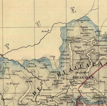
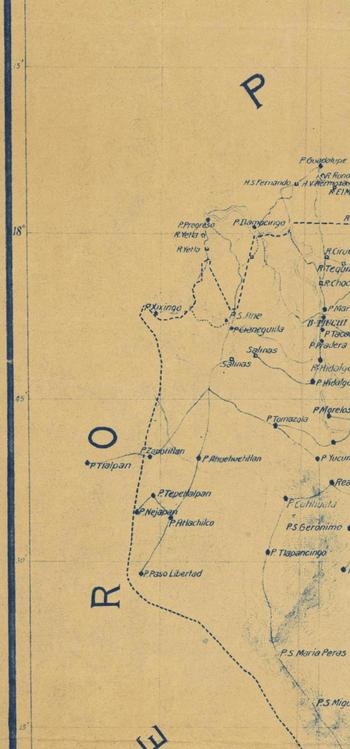
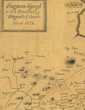
Although many of them were excellent by period standards, Oaxaca's numerous state maps proved impressionistic when it came to using them to mark or locate the boundary (Figure 1). This situation continued through to the end of the century. The most accurate maps during the late 1880s usually depicted Oaxaca nestled in among its adjacent federations at the preferred 1:100 000 scale, but with little more than a series of dashes providing the impression of the state's border.Footnote 67 In 1884, the renowned geographer Antonio García Cubas published what many considered the best map of Oaxaca in existence until the Comisión Geográfico-Exploradora (CGE) issued a meticulous, if as yet incomplete, state map in 1912 (Figure 2).Footnote 68 From independence on, most nineteenth-century maps portrayed the state's boundaries as equivalent to those administered by the Bishopric of Oaxaca, which produced its own maps (see Figure 3); to some degree marking and subsequently enforcing state power along the frontier represented an effort to demonstrate the sovereignty of the federation based on its ability to accurately produce geographic knowledge.
Detail from ‘Chorographic Map of Oaxaca and its Bishopric’ by Manuel Ortega Reyes, 1857

Detail from the Map of Oaxaca Produced by the Comisión Geográfico-Exploradora in 1912, Recommissioned 1916

Detail from 1824 Map of the State and Bishopric of Oaxaca Portraying their Territorialities as Equivalent

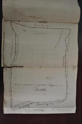
Local maps, if and when they did exist, were similarly problematic. They tended to represent the varied interests of competing frontier actors, from municipal councils and agrarian societies to private parties. They were just as unreliable as the various general state maps in resolving real-world boundary disputes because they related local spatial perceptions developed outside the register of contemporary cartographic science (Figure 4).Footnote 69 As in Veracruz, local actors often produced maps that distorted the depiction of area landscapes and thereby exaggerated claims to nearby territories.Footnote 70 Local maps usually served more as implied historical title to current land claims than as accurate guides to the surrounding topography and any political boundaries demarcated there. Officials thus knew well that the only way to produce an authoritative map of the state's boundaries was to survey the border and subsequently chart it from newly established, ‘definitive’ coordinates represented on site by boundary markers. To do this, a boundary commission would somehow have to mark the border in a manner agreed upon by the numerous parties involved in what was by all accounts a long history of recurrent disputes along the frontier.Footnote 71
Locally Produced Municipal Map of Zapotitlán Lagunas, Oaxaca, c. 1868

Therein lay the problem. There existed little agreement as to the exact location of the border for good reason: no such physical boundary had existed along the length of the state's frontier at any given time historically. Instead, what came to be commonly understood as the state's general borders during the era was the result of several intertwined and deeply layered cultural, linguistic and symbolic conventions – a colonial-era map or land title here, a major waterway or a pile of stones marking a lindero there. The existing mojoneras had been erected piecemeal at various times in the past and had since experienced innumerable, often controversial fates, especially where they marked boundaries between human populations, the exact places where such markers were reckoned most necessary. Nevertheless, many officials clearly believed that an objective, historically verifiable state boundary did in fact exist, and that effectively re-marking it was a formality dependent on securing proper historical and legal documentation.Footnote 72 Accordingly, boundary commissions usually considered a massive amount of locally produced evidence in their attempts to determine the border's correct location.Footnote 73
Oaxaca's first serious attempt to establish a commission to collect local data from which to survey and mark its boundaries did not take place until the 1840s under Governor Benito Juárez (1847–52), who linked the nation's political and social turmoil to its lack of geographic knowledge.Footnote 74 Yet, the state was not able actually to field a commission until the 1870s because generating the public funds necessary to finance such a logistical undertaking proved unrealisable.Footnote 75 Practical problems involved finding and kitting out enough qualified personnel to finish the work, whose arduous nature also presented an obstacle. Oaxaca's frontier region roughly marked its borders with surrounding states for good reason, and efforts to mark its boundaries in such isolated, difficult terrain cost several lives during the era.Footnote 76
Oaxaca's state government worked both independently and jointly with each of its neighbouring states to survey and mark its boundaries. Like other states, notably Puebla and Veracruz, Oaxaca contracted with the CGE to accumulate geographical information for the purposes of elaborating a state map. The height of these efforts occurred when engineers Abel Díaz Covarrubias and Clemente Rulfo were commissioned to determine coordinates for several Oaxaca and Guerrero localities so as to better determine the states’ respective boundaries in three 1902 ‘expeditions’.Footnote 77 Employing the ‘Mexican method’, these traverse surveys enabled cartographers to roughly sketch each of Oaxaca's political districts and to register some 1,166 previously ‘unknown’ communities.Footnote 78 CGE engineers did not carry out further work before the events of the revolution forced the organisation to suspend its operations. Nevertheless, based on its own incomplete work and considerable data provided by Oaxaca's various boundary commissions, the CGE produced its ‘definitive’ state map in 1912.
In general, federal law complicated the process of state boundary marking. According to Article 110 of the 1857 Constitution, the states, not the federal government, were responsible for such work, though the federal government would arbitrate disputes in such matters.Footnote 79 Thus, Oaxaca routinely named comisiones deslindadoras (boundary commissions) and charged them with carrying out this activity in cooperation with other states. In practice, Oaxaca regularly fielded three such commissions to work with their counterparts from Guerrero, Puebla and Veracruz between 1870 and 1911. Oaxaca never began its work with Chiapas before the revolution started, as the latter state was embroiled in its own límites conflict with Tabasco during the period.Footnote 80
Legally, each of the states involved in boundary marking was effectively a self-interested party seeking either to defend or to assert the existence of boundaries that best suited its individual territorial ambitions. This tendency was exacerbated when Oaxaca and the other states aimed to protect the claims of frontier municipalities seeking to extend jurisdictional limits as a source of tax income or the claims of private citizens holding title to lands in adjoining states. Parties from one state often purchased terrenos that effectively extended their properties across state lines. Hoping to avoid dealing with authorities in two different states, private landowners often sought and received backing from local authorities in their preferred federation, who in turn argued that the territories in question now fell under their jurisdiction.Footnote 81 As a result, even rigorous technical work carried out by one state commission often met with passionate criticism when it contradicted, as it frequently did, the findings of another state's comisión deslindadora. The work of even the most amicable ‘joint’ boundary commissions (Oaxaca and Guerrero in the late 1880s, for example) consequently wound up in drawn-out litigation, especially in appeals, forcing the states to establish new commissions to redo previous work.Footnote 82
The state's objectives in marking its borders were diverse. While definitive boundaries would, as several scholars have shown, facilitate administrative order by enabling the timely and fair collection of taxes and rents, these efforts did not only reflect the fascination of a centralising state bureaucracy with rationalising government. Securing the peace and generating income were, to be sure, major factors, but the government also clearly sought to respond to the demands of local officials and residents along the frontier, many of which – far from protesting against the implementation of clear boundaries – complained often of the complications they endured by their absence. Local residents habitually protested that the lack of defined boundaries effectively trapped them between districts in adjacent federations, where they were forced to pay multiple rents and taxes to competing state and municipal agencies.Footnote 83
Similarly, licences were often required in separate states and criminals could be tried numerous times for the same offence in overlapping jurisdictions. In the inverse cases, entire communities went altogether unrepresented. Since no state, district or municipality lay jurisdictional claim to the areas in which such communities were located, residents lacked basic infrastructure and resources.Footnote 84 And, for every case featuring a community resistant to the implementation of a distinct limit, an opposed party applauded its enactment. Clearly, frontier residents did not regard the work of delineating state boundaries as a mere imposition. Rather, many of them saw this work as crucial to their own interests and supported state efforts when a boundary favoured their interpretation. Whereas the enactment of permanent boundaries was always controversial because it threatened a tradition of malleable local land use, residents also saw the potential benefits of permanent sovereignty over specific tracts of land.
Delineating the Peace: Marking the Guerrero Border
Among the various efforts to mark Oaxaca's borders, the joint labours with Guerrero stand out as the most problematic, yet broadly representative, case study. The federal government created the state of Guerrero out of territories taken from Michoacán, Puebla and the Federal District in 1849. Despite the fact that no effort had ever been made to mark a border on the ground during the colonial or earlier national periods per se, Guerrero immediately inherited a series of ‘age-old’ boundary disputes among municipios located along its eastern frontier with Oaxaca.Footnote 85 Puebla's former jurisdiction over Guerrero's territorial limits in this area would cause considerable confusion in on-going límites conflicts with Oaxaca during the second half of the nineteenth century, to the extent that officials believed it impossible to understand Oaxaca's dispute with Guerrero without comprehension of the former and existing Puebla boundary controversies.Footnote 86
According to most period observers, the problems that Oaxaca and Guerrero began experiencing after 1849 stemmed from local judges and officials allegedly overstepping their authority.Footnote 87 Foremost, frontier courts in Oaxaca and Guerrero consistently approved territorial expansions into the other state. Local officials also apparently encouraged border residents to project municipal and private territories across state lines, often provoking violent conflict.Footnote 88 In combination, these administrative practices along the shared Oaxaca–Guerrero–Puebla frontier generated an enormous amount of ‘legal’ documentation supposedly justifying seemingly innumerable, contradictory land claims in the late nineteenth and early twentieth centuries. Local residents therefore believed that their actions, which higher officials usually interpreted as land invasions, enjoyed legal sanction; in fact, they did, often dating back decades or more. It was into this confused situation that boundary commissioners entered in the late 1880s. By 1910, several of these controversies had only intensified.Footnote 89
Interim Governor Mario Jiménez announced Oaxaca's latest and, to date, most serious efforts to mark a permanent border with Guerrero in August 1884. The initiative was intended not only to address confusion along the frontier evident since the Puebla era, but specifically to help resolve a conflict between residents of Ometepec, Guerrero, and José C. Añorbe's Rancho de Soto, Jamiltepec, which had recently resulted in several casualties.Footnote 90 Jiménez stressed that Oaxaca had to ‘defend its borders’ against the ‘unjustified’ Guerreran land invasions, and that ‘while not perfectly defined, our border is well-enough known to protect’.Footnote 91 Luis Mier y Terán, who became governor later that year, reiterated the state's desire to protect its territory from constant incursions from surrounding federations, particularly Guerrero. Nevertheless, the authorities continued to intervene in violent border disputes over the next few years until in January 1888, Mier y Terán and Francisco Arce (governor of Guerrero) established a commission to collect historical material by which to mark the border.Footnote 92 Paradoxically, the joint commissions were ordered to ‘establish a permanent and definite’ boundary that somehow ‘would not come under historical question’. Eventually, Mier y Terán clarified that the commissions would perfect ‘an established’ boundary.Footnote 93
The commissions met to discuss their joint venture in March 1888. Secretaries Agustín Alarcón (Oaxaca) and Gabriel Villanueva (Guerrero) made it clear during these meetings that their main intention was to ‘bring peace’ to the region by specifying the border's location. Couched in elaborate patriotic rhetoric, the meetings left no doubt that the commissioners saw their duties as closely related to nation building. They intended to ‘restore the ancient harmony’ that had at one time apparently existed along the border, and only the most loyal citizens had been called to perform these duties.Footnote 94 Asserting that harmony was necessary between the states that had produced the nation's two most important patriots – Vicente Guerrero and Benito Juárez – it was necessary to settle these ‘eternal boundary questions’ once and for all. Unfortunately, the commissioners immediately fell into disagreement regarding how work should proceed.Footnote 95
Wasting no time, entirely new commissions were organised in May.Footnote 96 When Oaxaca's chief engineer Emilio Brachetti died from health complications as the work began that summer, the state arranged yet another venture led by engineer Abelardo Ávalos. In January 1889, work was finally resumed. Embarking from the Pacific coast, the commissions made their way north along the frontier toward Puebla. Despite mutual agreement on 96 common boundary points, serious discrepancies over measurements and place names caused utter confusion. Boundary commissioners requesting legal title to locations in question soon recognised that local courts had complicated the issue by sanctioning land grabs across state lines. Respected local citizens were asked to weigh in as historical witnesses, reciting their interpretations of customary land tenure practices, which revealed a fluid, if not completely muddled, legal reality that seemed inimical to any effort to locate a ‘historically verifiable’ common boundary.Footnote 97
In a flash of genius, the commissioners at one point requested from both the state of Puebla and the National Archives a ‘definitive’ state map of Puebla, one made before Guerrero was created, which they believed would resolve the issue. Claiming they ‘desperately needed’ such a map, the commissioners were disappointed to learn that no such decisive evidence existed.Footnote 98 To complicate matters, commissioners also received word that several boundary disputes had erupted further afield toward Puebla. Villagers seeking possession of disputed territories along the frontier were occupying tierras in the hopes of convincing commissioners of the legitimacy of such claims once they arrived on the scene.Footnote 99 Thus, although the joint commissions managed to trudge their way along the entire boundary by July 1889, the work was never satisfactorily completed. Severe discrepancies remained.
Federal officials appointed General Mucio P. Martínez to preside over the inevitable arbitration in late 1889. Martínez, who later served as governor of Puebla (1893–1910), immediately called into question the strategies by which both the Guerrero and Oaxaca commissions used historical and legal documentation to evidence their claims. Using civil and penal records dating back to the colony, as well as locally produced maps, Oaxaca's attorneys had often cited occasions wherein landowners along the frontier had traditionally paid taxes in their state, or in which crimes committed along the frontier were tried there. Oaxaca officials also argued that in 1878 they had sent in troops to defend the Jamiltepec border, implying that collectively such occurrences ‘proved’ Oaxaca's historical dominion over disputed frontier territories.Footnote 100
Martínez accepted none of this, arguing that ‘incompetent’ local authorities had routinely overstepped their legitimate jurisdictions and had no right to proceed with such lack of authority. The arbitrator ruled that neither state was allowed to cite decisions from inferior district judges, whom Oaxaca itself in 1884 had barred from litigating in such matters.Footnote 101 This invalidated a tremendous amount of ‘legal’ evidence that both states had relied upon in making their respective cases. Martínez accepted only local documents – in particular land titles – that had emanated from authorities at the state, national or vice-regal levels. At one point in the arbitration hearings, which generally went badly for the state, Oaxaca officials claimed that a ‘Ley Territorial de Oaxaca’ protected their interpretation of the boundary, but Martínez maintained that only federal authorities could ratify a state's borders.Footnote 102
Martínez initially aimed to sort out controversial landmarks and place names so as to impose administrative clarity between the states. He ruled that in all instances whereby both states agreed upon a place name, that place would in turn be designated as a legitimate boundary between them. During the proceedings, both commissions were able to produce mutually recognisable place names up to a certain point, after which questionable evidence inevitably emerged. Martínez charged that both commissions were overstating the extent of their respective state's jurisdiction by fabricating these names.Footnote 103 Changing property boundaries and seemingly endless land invasions along the boundary made any allusion to historical place names nearly pointless. Martínez observed that several properties and villages had changed names over the years, while others featured either similar (Coyocoyul and Coyocoyul Viejo, for example) or even identical (separate ranchos named El Ciruelo, for example) place names.
Martínez chose instead to privilege natural boundaries as border markers. Ideally, geographic features in the landscape – rivers, mountains, seasonal watercourses, etc. – would, where possible, provide ‘natural’ divisions between the states. By comparison, privately owned properties and ever-changing municipal boundaries were far less preferable due to their man-made origins. Seen from this view, mojoneras erected to mark natural boundaries were not simply ephemeral objects used to separate people, but would instead make clear previously existing geographical divisions among otherwise united Mexicans.Footnote 104 Although some private properties henceforth would straddle the newly defined state limits, these would only slightly alter existing jurisdictions of border districts, ensuring a peaceful coexistence within the broader union. The insistence on designating ‘natural’ boundaries had the effect of reassigning agency for the creation of borders to the objective category of the region's physical geography and away from the material designs of competing bureaucracies and border populations, thereby ideally ending any dispute in the matter.
The commissions were then sent back into the field to mark the boundary from Laguna de Monte Alto in the south to Cabeza de los Tres Ríos near Puebla.Footnote 105 They erected mojoneras to designate a straight path between natural boundary markers and presented residents with news of the ‘permanent’ límites, often clarifying for locals the Spanish equivalent for Mixtec place names. Whereas the commissioners always took seriously any boundary evidence that locals presented in the field, they consistently disqualified documents written in ‘idioma extraño’ (literally, ‘strange (or odd) language’, for which read: Mixtec), effectively subsuming local historical claims into the preferred legal hierarchy of Spanish and Mexican officialdom.Footnote 106 Serious disagreements continued to occur; at one point Martínez forced commissioners to walk a portion of the boundary over which they disagreed on 16 successive border designations to see whose version proved more plausible. Local officials and surveyors traversed the boundary, usually accompanied by dozens of villagers who witnessed continued disagreements over its new location, yet – according to the commissioners at least – acquiesced to the decision enacted so as to bring peace to their communities.Footnote 107
No such peace came, as nearly all parties involved soon challenged the ruling. Local residents, still claiming the legal validity of district court decisions and customary land uses, immediately renewed their traditional strategies of destroying boundary markers and all-out land invasions. They also made extensive use of the legal and political systems, as local agrarian societies challenged opposing land claims and petitioned local, district and state authorities to intervene on their behalf to clarify their particular version of a boundary. By 1891, Zapotitlán Lagunas's many ongoing disputes had intensified.Footnote 108 Featuring both legal and direct action – including the production of still more locally financed apeos and deslindes, successive land occupations, the establishment of rural militias to protect land claims and several violent individual encounters – the dispute remained live even in 1913.Footnote 109
Officials in both states used these renewed límites disputes as an opportunity to appeal against Martínez's ruling, claiming that he had been incorrect to omit local historical and legal evidence of jurisdiction.Footnote 110 Renewed conflict along the border forced officials to re-establish the boundary, this time ‘provisionally’, in 1896, when Martínez himself returned to walk the boundary and attempt to clear up lingering discrepancies.Footnote 111 Another ‘provisional’ marking took place in 1903. For its part, Zapotitlán became embroiled in a pernicious límites dispute with nearby Xixingo, Puebla, that eventually drew Oaxaca into controversy regarding the entire frontier boundary with Puebla, which officials claimed had previously been ‘well-established and respected’.Footnote 112 In each of these cases of renewed controversy, local authorities and residents challenged the validity of the boundary's novel permanence, again relying on municipal documents to assert the historical validity of their present territorial claims.
Despite these recurring problems, Oaxaca's arbitration with Guerrero resulted in a strong statement of the supremacy of centralised judicial power. Interestingly, in arguing for its own jurisdiction, the state of Oaxaca had hoped that arbitration would effectively reinforce local autonomy as represented by the historical and legal evidence it could produce in these proceedings, almost all of which emanated from the frontier itself.Footnote 113 But Martínez ruled otherwise and, in the process, the tradition of a fluid border that mutated according to local practices at least officially gave way to the state's heightened preoccupation with permanency and hierarchy during the Porfiriato. Rather than simply reinforce Oaxaca's federal sovereignty, permanent state boundaries also ironically expressed the presence and power of the federal government, whose territorial dominion was now, at least in theory, precisely delimited in the form of Oaxaca's state border.
Conclusion: The Limits of State Formation
Drawing on the works of Antonio Gramsci, Raymond Williams, and Philip Corrigan and Derek Sayer, Mexicanists have in recent decades largely regarded state formation as a process wherein power holders, social groups and individuals continually renegotiate the parameters of authority.Footnote 114 Many scholars see state power as contingent upon consent from below and have focused on the efforts of subordinates to avoid impositions through individual and collective acts of ‘resistance’, resulting in an uneasy social consensus.Footnote 115 On the one hand, Oaxaca's efforts to mark its state boundaries represented a literal act of state formation wherein it attempted to outline the limitations of its authority on the ground in ‘cooperation’ with other federations and with its own citizens. On the other, the process featured several different levels of government – from the municipal and district to the state and federal – attempting to etch out the parameters of their distinctive jurisdictions in a metaphorical sense during an era of marked centralisation.
The campaign to clarify internal boundaries faced numerous challenges. While rationalised among Oaxaca officials as a necessary step toward overcoming ‘age-old’ límites conflicts on the frontier, the process in many ways demonstrated the limits of state formation in late nineteenth-century Mexico. Most significantly, rigidly defined internal boundaries, which officials quite menacingly billed as newly ‘permanent’, exacerbated divisions among citizens and often led to conflict. Even so, and perhaps strikingly given the urgency of the matter, state authorities never sought simply to impose a boundary on frontier residents. Authorities clearly attempted to respect citizens’ appreciation of the frontier landscape by consistently examining the seemingly endless supply of documentation on the local history of land tenure. For their part, rural residents continually participated in the negotiation of boundaries. They alternately rejected or embraced proposed state lines depending on their agreement with area tenancy practices and local desires to collect or to avoid rents.
In so doing, frontier residents did not simply ‘resist’ some inevitable transition to the enactment of modern state power. Rather, they were perhaps able to ‘reposition’ themselves within the redefined parameters of centralised state authority during the era not by rejecting permanent borders and governmental hierarchy outright, but by making clear their preferences regarding the circumstances under which these borders were to be implemented.Footnote 116 Importantly, the actions of frontier residents not only seriously disrupted the state's efforts to implement its permanent boundary; they literally became the boundary itself. The GCE's 1912 map of Oaxaca, though imperfect from a technical perspective, nevertheless provided an accurate portrait of the state's borders in vernacular terms that ironically demonstrated the limitations of state knowledge and authority. In practice, the state's ‘definitive’ map proved useless in determining the outcome of persistent land disputes.
The actions of frontier inhabitants did more than to simply foil the state's efforts to clarify its border. They also generally had the effect of reinforcing local sovereignty that, in the end, seemed to enjoy more allegiance along Oaxaca's frontier than did either the state or national governments. In light of this, it is remarkable that scholars of late nineteenth-century Mexico continue to emphasise the state's authority and hegemony as opposed to what Andrew Mathews would call its ‘instability and fragility’, the latter becoming eminently clear in 1910.Footnote 117 If frontier Oaxacans by and large never saw fit to take up arms against the state during the revolution, it was perhaps because the central state's power was never fully solidified there. And where it was, locals themselves defined the boundaries of its rule.