Long regarded as cost-effective and time-efficient solutions for archaeology (e.g., Conyers Reference Conyers2013; Schmidt et al. Reference Schmidt, Linford, Linford, David, Gaffney, Sarris and Fassbinder2015), remote sensing offers a possible solution to aid both Indigenous communities and archaeologists in the protection of heritage (Wadsworth Reference Wadsworth2020). Both groups appreciate the technique's non- or minimally invasive impacts to cultural sites and their ability to expedite archaeological timelines (Gonzalez Reference Gonzalez2016; Johnson and Haley Reference Johnson, Haley and Johnson2006; Supernant Reference Supernant2018). Despite these obvious benefits, only a few archaeologists practicing Indigenous archaeology have incorporated geophysics into their research programs (but see Gonzalez Reference Gonzalez2016), and conversely, only a small number of archaeologists who specialize in remote sensing apply their techniques within community-based or public archaeology models (e.g., Henry et al. Reference Henry, Mink, W, McBride, McKinnon and Haley2017). The use of remote sensing for public archaeology, however, broadly differs from its potential application to Indigenous archaeology. Indigenous archaeologies require changes to the design, process, and interpretation of archaeological results (Atalay Reference Atalay2012; Lyons Reference Lyons2013; Supernant and Warrick Reference Supernant and Warrick2014; Tuhiwai-Smith Reference Tuhiwai-Smith2012), including remote sensing. Reorienting remote sensing under an Indigenous archaeology paradigm serves to not only bridge the gap between Indigenous communities and archaeologists but also contribute to the decolonization of archaeological practice.
In this article, we focus on a specific, culturally sensitive application of community-driven geophysics to locate Indigenous unmarked graves in Canada's subarctic. Through our partnership with the Chipewyan Prairie First Nation, we demonstrate the utility of incorporating Indigenous archaeology principles and Indigenous Knowledge (IK)–informed strategies to the design, implementation, and interpretation of a GPR unmarked grave survey. We then discuss how input from the community changed survey strategies, and we consider the potential benefits and limitations of our approach in contributing to Indigenous-oriented archaeological remote sensing.
INDIGENOUS CRITIQUES OF ARCHAEOLOGICAL PRACTICE
Indigenous critiques of archaeology as a destructive and extractive discipline (Tuhiwai-Smith Reference Tuhiwai-Smith2012) are finally being heard by some archaeologists (Atalay Reference Atalay2012; Colwell Reference Colwell2016; Nicholas and Andrews Reference Nicholas, Andrews, Nicholas and Andrews1997; Nicholas and Markey Reference Nicholas, Markey, Chapman and Wylie2015; Silliman Reference Silliman and Silliman2008; Supernant Reference Supernant2018). Although some early authors had acknowledged Indigenous concerns about representation and voice, it was not until the late 1990s that the concerns of descendant communities became a significant focus (Nicholas and Andrews Reference Nicholas, Andrews, Nicholas and Andrews1997). Indigenous archaeology takes many forms, but at its heart, it is archaeology “done by, with, and for Indigenous peoples” (Nicholas and Andrew Reference Nicholas, Andrews, Nicholas and Andrews1997:3; see also Martinez Reference Martinez and Smith2014; Nicholas Reference Nicholas and Pearsall2008). Although still not the dominant form of archaeology today, Indigenous archaeology in its many forms is a growing force across the discipline (e.g., Colwell Reference Colwell2016; Gonzalez Reference Gonzalez2016; Silliman Reference Silliman and Silliman2008; Supernant et al. Reference Supernant, Baxter, Lyons and Atalay2020).
Recently, archaeologists have begun to address critiques of the field's colonialism by generating community-based and collaborative practice models (Atalay Reference Atalay2012; Colwell Reference Colwell2016; Lyons Reference Lyons2013; Silliman Reference Silliman and Silliman2008). Although community-based and collaborative archaeologies are applied in various contexts globally, they are a core methodological component of Indigenous archaeology, and much of the literature on community-based archaeologies (especially in North America) has emerged from partnerships between Indigenous communities and archaeologists (Atalay Reference Atalay2012; Colwell Reference Colwell2016; Colwell-Chanthaphonh and Ferguson Reference Colwell-Chanthaphonh, Ferguson, Colwell-Chanthaphonh and Ferguson2008; Silliman Reference Silliman and Silliman2008). Following decolonized practices, Indigenous communities should be involved partners and initiators of archaeological research projects wherever possible. This results in research problems and designs that are different from projects that are initiated solely by archaeologists who are not members of the community (Atalay Reference Atalay2012; Colwell Reference Colwell2016; Tuhiwai-Smith Reference Tuhiwai-Smith2012). When work is conducted in ways that address community needs, more holistic questions are asked and different kinds of information are obtained. The results are more meaningful to the individuals, families, and communities closely connected to their history, and investigations may parallel personal journeys of identity for community members (Lyons Reference Lyons2013). Indigenous archaeology projects are grounded in respect, and they often use low-impact approaches that recognize and incorporate Indigenous Knowledge and community perspectives of the past (Gonzalez Reference Gonzalez2016; Supernant Reference Supernant2018; Zimmerman Reference Zimmerman, Smith and Wobst2005). In many cases, non- or minimally destructive field methods are preferred by Indigenous communities (Gonzalez Reference Gonzalez2016; Supernant Reference Supernant2018).
At the same time as Indigenous archaeology gained momentum, an increasing number of archaeologists began to adopt geophysical and remote sensing techniques for similar reasons (e.g., Conyers Reference Conyers2013; Kvamme Reference Kvamme2003). These applications are often touted as a more ethical form of archaeology given their nondestructive nature (McKinnon and Haley Reference McKinnon and Haley2017). Despite thematic similarities and crossover potential, few researchers have engaged in both Indigenous archaeology and remote sensing, and remote sensing applications at times have echoed or enhanced the extractive/colonial nature of the discipline. Remote sensing is often used to limit the amount of time spent on a site while extracting the most amount of data, and these projects are often significantly shorter than excavations (Johnson and Haley Reference Johnson, Haley and Johnson2006:43–44). For example, “multi-instrument” surveys have become commonplace in archaeological geophysics to maximize data collection, solidify interpretations, and limit time/resource constraints. Although some government bodies regulate the practice of archaeological geophysics more stringently, there remain many regions (such as in Canada) where heritage acts and legislation enable the “fly-in/fly-out” nature of remote sensing by not having as extensive licensing, permit, or consultation requirements as other forms of archaeology (Province of Alberta 2013; Province of British Columbia 1998; Wadsworth Reference Wadsworth2020:29).
Indigenous archaeological sites remain a common target for geophysical surveys. Despite investigating these sites with more ethical methods than traditional archaeology, not changing remote sensing methodologies to incorporate decolonized practices can be a “move to innocence” by researchers (Tuck and Yang Reference Tuck and Wayne Yang2012:19–20). Although the nondestructive aspect of the research is positive, it does not change the fact that many projects and their results remain outside the purview and control of the Indigenous communities they affect. This issue is even more egregious when government policies deny communities access to information about their ancestors and sacred places. Although the circumstances presented here do not encompass the entirety of archaeological remote sensing, due to the variety of geographic and legal contexts in which archaeological geophysicists work, we wish to draw attention to a problem and an opportunity. Remote sensing can perpetuate similar issues critiqued of archaeology, such as projecting Western objectives onto Indigenous pasts and extracting data for “science.” But practitioners of archaeological remote sensing can also advocate for Indigenous objectives and community access to and ownership of cultural heritage data, when possible. To seize this opportunity, archaeological projects should incorporate these nondestructive techniques within community-driven/collaborative methodologies that seek to uphold Indigenous sovereignty and address community objectives.
COLLABORATIVE/COMMUNITY-DRIVEN FRAMEWORKS AND REMOTE SENSING
Archaeology that involves public outreach and communicating interpretations to the “public” is often deemed “public archaeology” (Atalay Reference Atalay2012), and archaeological geophysics is increasingly applied within these settings (e.g., Henry et al. Reference Henry, Mink, W, McBride, McKinnon and Haley2017; Horsley et al. Reference Horsley, Wright and Barrier2014). Although public archaeology requires community consultation, permission, and engagement with residents on or adjacent to archaeological sites, it does not necessarily mean that these individuals are always included as stakeholders (Wright Reference Wright2015), and their knowledge may go underrecognized in interpretation. Indigenous and collaborative archaeologies differ principally from—and in many ways expand on—public archaeologies because they ask questions about research relevance, audience, and benefits to the associated or descendant community (Atalay Reference Atalay2012:2, 44, 237). They also center Indigenous ways of knowing by recognizing settler colonialism, privilege, and power dynamics in ways that public archaeology does not (Atalay Reference Atalay2006; Supernant Reference Supernant2018). On Indigenous archaeology projects, research objectives and methods are often determined by communities rather than the archaeologist, and communities have stronger voices (Atalay Reference Atalay2012; Colwell Reference Colwell2016; Supernant et al. Reference Supernant, Baxter, Lyons and Atalay2020). This article integrates principles of heart-centered archaeological practice (Lyons and Supernant Reference Supernant, Baxter, Lyons and Atalay2020; Supernant et al. Reference Supernant, Baxter, Lyons and Atalay2020), an approach that foregrounds these personal relationships, community needs and respect, knowledge transparency, and interdisciplinarity to accomplish partner community goals (Supernant et al. Reference Supernant, Baxter, Lyons and Atalay2020).
When Indigenous peoples have been included on archaeology projects, they have often been relegated to roles as local informants or field assistants employed to provide manual labor, give access to areas, and assist in the location of archaeological sites (Colwell Reference Colwell2016; Nicholas and Markey Reference Nicholas, Markey, Chapman and Wylie2015). Listening to Indigenous communities about their needs and objectives, as well as respecting their knowledge and historical narratives as equal to science, has only recently been discussed (Atalay Reference Atalay2012; Nicholas and Markey Reference Nicholas, Markey, Chapman and Wylie2015). Although some authors have preferred “traditional knowledge” to describe Indigenous peoples’ knowledge of their environment, landscape, and culture, we prefer the term “Indigenous Knowledge” (IK). The term “traditional knowledge” suggests that the knowledge is somehow static, when in practice, it is dynamic and ever evolving. Specifically, “traditional” does not recognize the diverse traditional and contemporary knowledge systems that exist in Indigenous epistemologies, relegating “useful” knowledge to the past. Following Stevenson (Reference Stevenson1996), this article uses “Indigenous Knowledge” to encompass traditional/nontraditional and ecological/nonecological (social, cultural, and spiritual) knowledges, recognizing the usefulness of different epistemologies under a more inclusive term. We prefer this term because it is more empowering for communities and less contentious (Stevenson Reference Stevenson1996). Despite some contestation over the use of IK within archaeology, we see value in critical multivocality and the beneficial co-creation of knowledge between communities and researchers (Colwell Reference Colwell2016; Ferguson et al. Reference Ferguson, Koyiyumptewa and Hopkins2015; Nicholas and Markey Reference Nicholas, Markey, Chapman and Wylie2015).
In archaeological remote sensing, “multistage” methodologies (carrying out geophysical surveys at different scales throughout the research process) have been shown to drastically improve the way archaeologists approach sites and the questions they ask (Henry Reference Henry2011; Henry et al. Reference Henry, Laracuente, Case and Johnson2014; Horsley et al. Reference Horsley, Wright and Barrier2014). Researchers who use these methodologies, however, are still approaching archaeological questions from a geophysical or archaeological worldview. Collaborative and community-driven frameworks allow us to integrate IK and remote sensing together throughout the entire research process, as is the case with multistage remote sensing. Indigenous communities drive this research, bring their own questions and personal relationships to sites, and control the outcomes of projects and the data produced. Actively including community members creates a dialogue between fields where geophysical, archaeological, and Indigenous Knowledges can interact. It is here that both researchers and communities derive mutual benefit from the noninvasive production of knowledge. The combination of geophysics and Indigenous archaeology offers an avenue to change methodological design, process, and interpretation of heritage resources. These fundamental changes invert how these fields have interacted in the past, and Indigenous Knowledge is no longer used to supplement archaeological survey. Instead, archaeological remote sensing is used to supplement and aid Indigenous Knowledge and community goals. Moreover, working within this interdiscursivity allows for greater anthropological insights to be generated (in line with the recent anthropological turn within geophysics; e.g., Conyers Reference Conyers2010; Horsley et al. Reference Horsley, Wright and Barrier2014; McKinnon and Haley Reference McKinnon and Haley2017; Thompson et al. Reference Thompson, Arnold, Pluckhahn and Vanderwarker2011). Although the utility of this emerging combination has yet to be fully realized, we illustrate below how community-driven approaches and decolonization theory can—in our experience—be applied to the most requested survey by Indigenous communities: the unmarked grave survey.
GPR AND UNMARKED GRAVES: PAST AND FUTURE CONTEXTS
Archaeologists have used ground-penetrating radar (GPR) to investigate unmarked grave contexts since its earliest adoption in archaeology (Conyers Reference Conyers2012, Reference Conyers2013; Gaffney et al. Reference Gaffney, Chad Harris, Pope-Carter, Bonsall, Fry and Parkyn2015; Goodman and Piro Reference Goodman and Piro2013). Detailed explanations of how GPR operates are available elsewhere (e.g., Conyers Reference Conyers2013; Goodman and Piro Reference Goodman and Piro2013), but it is important to mention that GPR differs from other geophysical techniques because it attempts to record and discriminate the size, shape, and derived depth of reflections created by subsurface objects. Using processing software, GPR data can be analyzed as reflection profiles, top-down amplitude maps/time-slices, or 3D volumes (Goodman and Piro Reference Goodman and Piro2013). Generally speaking, when the same graves can be clearly located in multiple types of GPR analysis (i.e., profile and amplitude data), it is taken as a sign of high confidence in grave interpretation (Conyers Reference Conyers2012; Gaffney et al. Reference Gaffney, Chad Harris, Pope-Carter, Bonsall, Fry and Parkyn2015; Wadsworth et al. Reference Wadsworth, Bank, Patton and Doroszenko2020). Today, GPR is widely recognized as one of the most consistent techniques for unmarked grave investigations (Conyers Reference Conyers2012; Gaffney et al. Reference Gaffney, Chad Harris, Pope-Carter, Bonsall, Fry and Parkyn2015; Wadsworth et al. Reference Wadsworth, Bank, Patton and Doroszenko2020).
Historic cemeteries have received a great deal of attention by North American archaeologists and GPR professionals (Conyers Reference Conyers2012). When the criteria for a “grave-shaped” GPR reflection is reflexively examined, it is clear that these are based on a priori assumptions about burial culture, physical character, size, inclusions, and associations to other graves. In settler-associated cemeteries, these assumptions may not always be simple, but they are fairly intuitive, with variance largely being based on religion, ethnicity, class, and event (e.g., Conyers Reference Conyers2012; Ruffell et al. Reference Ruffell, McCabe, Donnelly and Sloan2009). These graves typically follow a rough template of up to 6 ft. (~1.8 m) deep and are 1–2 m in length. They often have limited grave inclusions, are organized into loose rows, and typically consist of coffin burials. In some cases, the stacking of coffins and presence of mass graves within cemeteries have also been recorded (Conyers Reference Conyers2012).
It is important to note that non-European cemeteries (or those of their descendants) appear to be far less investigated in the published literature. This is likely due to two factors: (1) the majority of the development and application of geophysical and remote sensing technologies has been concentrated in Europe (Schmidt et al. Reference Schmidt, Linford, Linford, David, Gaffney, Sarris and Fassbinder2015), and (2) surveys with these minority communities are often treated with a necessary higher degree of sensitivity and confidentiality. When these burial grounds are investigated and are allowed to be published, however, a priori assumptions of burial practices and the historic cemetery template are less applicable (e.g., Conyers Reference Conyers2012:147–150; Wadsworth et al. Reference Wadsworth, Bank, Patton and Doroszenko2020). More specifically, Indigenous burial grounds are often linked to larger cultural landscapes, and they involve more anthropological issues beyond pure identification, including why these cemeteries are there, how/why they are unmarked, what the imminent risks are, and what their potential role is in land claims. The typical assumptions are further confounded by variables that differentially affected these communities and further changed the nature of their burial grounds (for example, the long history of systemic oppression, racism, epidemics, warfare, and starvation policies that decimated Indigenous communities during the 1800s; Daschuk Reference Daschuk2013). Although it is a challenging pursuit, the location of ancestors and burial grounds is a priority for most Indigenous communities (Supernant Reference Supernant2018), and Indigenous archaeology approaches afford a much-needed sensitivity to this research that changes how these techniques are applied. At the request of the Chipewyan Prairie First Nation (CPFN), an opportunity was presented to apply these principles to an unmarked grave survey at the Cowpar Lake Burial Ground, an unregistered cemetery known only through Indigenous Knowledge.
STUDY AREA: CHIPEWYAN PRAIRIE FIRST NATION
Cultural and Historical Context
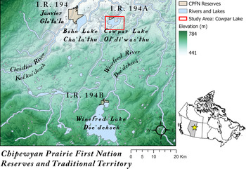
Chipewyan Prairie (Glo'ta’la) is an Athabaskan speaking, Déné'suline (or “Chipewyan,” a term derived from Cree) community situated in northeastern Alberta, Canada (Figure 1). Members have close relations living in Garson Lake and La Loche, Saskatchewan, and they are part of what Jarvenpa (Reference Jarvenpa1980:43–44) described as the kesyehot'ine—“Poplar House People.” The originating clans of Chipewyan Prairie (Bunion of Rabbits, Sagista, Chicken Neck, Old Man, and Porcupine Foot) derived their livelihood and identify from lands radiating outward from Winefred Lake (Doe'dehseh), Christina Lake (Ol'di’zan'thu), Christina River (Kai'kos’deseh), Cowpar Lake (Ol'di’was'thu), and Bohn Lake (Cha'la’thu). Today, CPFN members are signatories to the historic Treaty No. 8, with three reserves set aside for their use, including I. R. 194 Janvier (120 km south of Fort McMurray, Alberta), I. R. 194A Cowper Lake, and I. R. 194B Winefred Lake.
A portion of the Chipewyan Prairie First Nation's traditional territory in northeastern Alberta (★ on the map of Canada), with place names mentioned in text. Created in ArcGIS Pro. See Data Availability Statement.

Since the time of contact with settler populations, Déné'suline, like many Indigenous groups in Canada, have suffered dramatic population declines as a result of pandemics caused by infectious diseases such as influenza and tuberculosis. One such pandemic, the Spanish Flu of 1918–1919, reached deep into Chipewyan Prairie territory when it affected families living at Cowpar Lake. After succumbing to what was believed to have been the flu, approximately 14 Déné'suline were buried with much care in a sandy jack-pine area (guni thaze) overlooking Cowpar Lake. One elder believed that all of the individuals died over winter and that in spring they were buried all at once. They were buried in a manner that combined both Roman Catholic and local burial practices, with some graves surrounded by round cobbles and others having the remnants of white wooden crosses laying on them. It is believed that the white wooden crosses (which currently are almost disintegrated) were added about 35 years ago.
Research Problem
One hundred years later, many of the people of Chipewyan Prairie reside in Janvier and have seasonal cabins at Cowpar Lake, at Winefred Lake, and on their traplines. Prompted by challenges with addictions, Chipewyan Prairie began the construction of healing cabins on the shore of Cowpar Lake. In anticipation of increased off-highway vehicle traffic in the area, CPFN leadership decided that the Cowpar Lake Burial Ground, with few visible surface remains, should be fenced off to ensure that the graves were not impacted unintentionally. Known primarily through IK, there was limited recorded information available about the burials. Consequently, leadership feared that constructing the fence without knowing the extent of the burial ground could potentially impact the graves. Before construction, they sought reassurance that the fence they built would encircle all of the graves.
The GPR survey was conducted in order to delineate the graves and inform fence construction diameters. This was not the first time that the authors (Wadsworth and Supernant) had conducted an unmarked grave survey at the request of an Indigenous community. In fact, part of the reason this opportunity arose was due to the completion of similar projects that resulted in positive outcomes, which led to the researchers becoming known among some Indigenous networks. Prior to this project, only one of us (Dersch) had strong relationships with the members of the Chipewyan Prairie First Nation. Per Dersch's suggestion, the University of Alberta team was invited by the community to conduct geophysical surveys of the gravesites at Cowpar Lake.
Geographical Context
CPFN's traditional territory falls within the Athabasca Oil Sands region of Alberta, a well-known area with a long history of resource extraction (Conly et al. Reference Conly, Crosley and Headley2002). The sandy near-surface deposits (which make this area viable for oil extraction) also permit geophysical/GPR research (Conyers Reference Conyers2013; Goodman and Piro Reference Goodman and Piro2013).
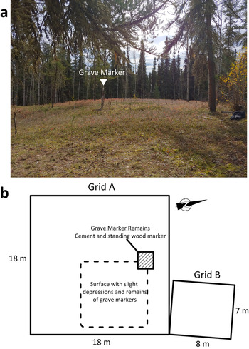
The Cowpar Lake Burial Ground is situated on a raised sandy area above the lake's shore (Figure 2). A small clearing surrounded by open pine forest, the area is accessible via a maintained dirt road that crosses small wetlands. The area was very flat and had limited obstructions aside from small sapling trees that were either pushed aside or cut down by community members. Many large pieces of old wooden grave markers were found distributed across the site. In some areas, slight surface depressions corresponded to these marker fragments.
(a) Photo of the survey area. Part of one grave marker still stands, with many wood pieces scattered around it. Slight surface depressions / vegetation changes are visible as one walks across the burial ground (photo by William T. D. Wadsworth). (b) Diagram of the survey grids. Grid A was 18 × 18 m, and Grid B was 8 × 7 m. Only one obstruction was present—the cement/wood remains of one grave marker. Although the surface was flat, there were slight depressions in the eastern portion of the grid.

Research Context
It is well known that unmarked grave investigations should strive to incorporate multiple techniques when possible to increase confidence in the geophysical results (Gaffney et al. Reference Gaffney, Chad Harris, Pope-Carter, Bonsall, Fry and Parkyn2015). Given the nature of CPFN's needs and time constraints, however, this was not realistic. This study focused on a ground-penetrating radar survey that sought to (1) identify/characterize the burials and (2) delineate their extent so that CPFN could construct a protective fence.
This is not the first time that geophysical techniques have been used to address archaeological questions in northern Canada (e.g., Landry et al. Reference Landry, Ferguson, Milne, Serzu and Park2019), and this is also not the first study to undertake an unmarked grave survey with Dene communities (e.g., Moorman Reference Moorman2003). The latter research project was a community initiative and used IK to determine burial ground locations and interment information. These researchers also found IK useful in the absence of historical information.
It is our privilege, with the permission of and in collaboration with Chipewyan Prairie First Nation's leadership, to share the results of the following survey in the hopes that it will help to connect communities and archaeologists in the advancement of Indigenous issues.
SURVEY SPECIFICS
This project was driven by the Chipewyan Prairie First Nation, and it sought to complete the community's objective of locating the graves and protecting the burial ground. It was funded solely by the Nation, with in-kind support from the Institute of Prairie and Indigenous Archaeology / University of Alberta. As a result, the impetus of the project, the location of the cemetery, and the cause of the burials, along with their expected characteristics, were made known to researchers only through IK and personal relationships with community members.
CPFN determined the survey location from IK, and community members took the research team to the location along Cowpar Lake. The survey design decisions that typically guide an unmarked grave survey were also primarily drawn from IK and community members’ participation. At the survey site, community members and an elder were asked about the nature of the graves at the burial ground. Questions asked revolved around depth, material composition, grave structure, orientation, date and circumstance of death, and identity of the graves. Despite the fact that most Chipewyan Prairie members were Roman Catholic, IK suggested that the burials had been done in a more local style—approximately 3 ft. (~0.9 m) deep and oriented toward Cowpar Lake. Community members did not think that coffins had been used.
GPR settings and grid/survey orientation were determined based on the information provided by community members, and rectilinear grids / survey transects were placed in order to bisect the expected graves perpendicularly (Figure 2). The entire area that the community requested was surveyed as part of two grids; Grid A (18 × 18 m) was centered over the burial area, and Grid B (7 × 8 m; offset to avoid two large trees and other obstructions) was an expansion of the survey to confirm that no graves had been missed. A GSSI-SIR 3000 controller with a 400 MHz center frequency analog antenna and distance-measuring survey wheel was used to conduct the survey. Survey transects were conducted unidirectionally over both grids, and transects were spaced in 25 cm intervals to maintain a resolution that was high enough to detect the same grave in multiple profiles. Readings were logged at a rate of 50 scans/m, samples were set to 1,024, and 3 gain points were set automatically at the beginning of the survey and consistently used throughout the project. As there was prior knowledge of burial practices by community members, two-way travel time (TWTT) was set to record up to 60 ns (a conservative estimate) in order to capture graves less than 6 ft. (~1.8 m) deep.
During the survey, the community members wished to know where the graves were “on the fly.” Although this is not always possible given the processing time needed to extract useful information from GPR data, it was possible during the CPFN survey. The sandy matrix allowed for the easy identification of most graves in-field because there was little background noise and the grave reflections were very clear. A councilor for CPFN began to demarcate the graves as we conducted the survey. Graves were marked at the “head” and “feet.”
When working with Indigenous communities, we prefer, when possible, to use free or cost-effective processing software so that if communities ever need to replicate the results, the cost is reduced. To process the data, we used a free suite of programs—GPR Viewer (2016) and GPR Process (2010), developed by Dr. Lawrence Conyers and Jeffrey Lucius. TWTT was converted to depth using hyperbola fitting estimation in GPR Viewer, which determined the dielectric permittivity to be about 11 (appropriate for mixed dry sand/silt soils; Conyers Reference Conyers2013). The reflection profiles were time zeroed, and a basic background removal filter was applied. These profiles were then “sliced” into 3 ns time slices using GPR Process. To visualize the data, Golden Software's Surfer 19 was used to construct the amplitude maps (despite the fact that this particular software is not free, the XYZ data produced by this workflow can be visualized using other open-source programs). As previously described, graves were first identified in profile and then compared to amplitude maps before we made our final conclusions. Following the analysis, a confidential technical report and data archive were prepared for CPFN. Because the survey was on reserve land (consequently, under federal jurisdiction), no additional reporting or permitting was required beyond the requirements set by the CPFN.
RESULTS
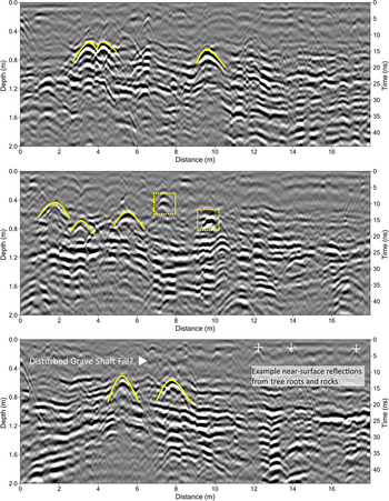
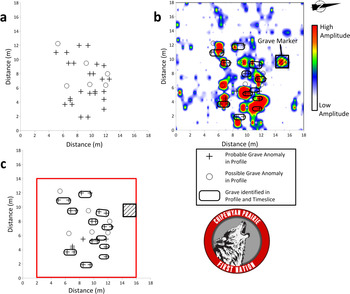
The IK-informed survey at Cowpar Lake was successful at locating the unmarked graves (Figures 3 and 4). There were many surface reflections from tree roots and small rocks, but these did not obscure grave identification. Many GPR reflections displayed the “grave-shaped” hyperbola character of shroud burials or wood coffins (Figure 3; Conyers Reference Conyers2012:130–136). Furthermore, most grave shaft reflections were found at a consistent depth of 70–90 cm (approximately 3 ft. deep). Many of these graves were found to be consistent with slight surface depressions and visually noted vegetation changes observed by community members and researchers. In the profiles, six possible grave-shaped hyperbolae were recorded. Either these were not represented in adjacent profiles, or their shape/character was deemed questionable. Twelve grave-shaped reflections were found to meet the IK parameters/assumptions set at the start of the survey, many appearing in a number of profiles often spanning 1–2 m. These identified graves were represented in both reflection profiles and amplitude maps, adding confidence to their interpretation (Figure 4). Although we suggest that the other reflections may also be graves, these 12 were most convincing in their identification. It is also worth noting that this number was also roughly how many graves the community expected to be in the burial ground based on IK.
Annotated GPR profiles from different parts of the Cowpar Lake Burial Ground. The yellow annotations indicate the grave-shaped radar reflections resulting from either wooden coffin or shroud burials. The dotted lines indicate possible grave reflections, but they had characteristics that cast doubt, such as variance in shape or depth. Disturbed soil is seen above some of the hyperbolae, possibly representing the grave fill. Surface reflections from tree roots and rocks were found across the survey, and some of these are identified on the bottom reflection profile (+). The GPR reflection profiles shown here were visualized in GPR Viewer (2016).

(a) Post map of “head” and “feet” of graves identified in GPR profiles. Circles denote possible grave-shaped reflections, and black crosses denote probable grave-shaped reflections; (b) GPR profile interpretations overlaid on 3 ns thick amplitude map at 80–90 cm deep (approximately 3 ft.); (c) Identified graves as a post map with shapes interpreted from the profiles and amplitude map. A minimum fence boundary of 14 × 14 m was recommended by the researchers (shown in red). The GPR amplitude maps shown here were created in GPR Process (2010) and visualized in Surfer (19.2.213).

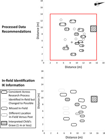
With regard to the “on the fly” mapping of graves, this process helped to include the community in a way that was meaningful, given that remote sensing data can be very technical. Although not a complete picture of the final survey results, this in-field marking strategy was later shown to be fairly accurate, and it made a great difference for the community members, who could see the research in action (Figure 5). It was also beneficial to the research project because it facilitated the sharing of IK and co-created ideas about the burial ground as it began to emerge.
Comparison between post-processing data recommendations and in-field identification of unmarked graves. Although the processed data is deemed the most “accurate” in terms of technique, the addition of Indigenous Knowledge changed how the burial ground was interpreted. Although the integration of these datasets did not change the overall burial ground layout, it did slightly change the location of specific graves and their identities. Following the community's wishes, child versus adult graves were identified.

The in-field identification allowed for community members to have a rough estimate about the resources needed to protect the burial ground, and interpretations were later confirmed with the visualization of the GPR data and creation of amplitude maps. The boundaries of the Cowpar Lake Burial Ground were delineated, and they included all possible associated reflections. The graves were largely concentrated in one part of the survey area and oriented in rough rows—which makes sense given the Roman Catholic influence in the area. Because the grid was surrounded by trees, expansion of the survey was only possible to the north. A small grid (7 × 8 m) was surveyed, but no additional graves were identified. Consequently, it was concluded that the GPR survey had delimited the boundaries of the burial ground. If protective measures were to be taken, it was recommended that a minimum area of 14 ×14 m, centered on the identified grave reflections, should be fenced so as not to disturb the burials (Figure 4c).
There were some clear grave-shaped reflections that only occurred in a few profiles (around or less than a meter). Typically, these would have been classified as possible graves. Consultation with community members, however, revealed that it was their wish to interpret these as the possible graves of deceased children (Figure 5). Out of the 12 graves identified in both profiles and amplitude maps, up to six befitted this interpretation. It is important to note that other reflections originally identified as possible graves may also represent this category. The size, shape, and orientation of these reflections, however, were different from the other graves, which cast doubt.
DISCUSSION
It has been almost two decades since Kvamme (Reference Kvamme2003) published the seminal article “Geophysical Surveys as Landscape Archaeology,” in which he described how geophysical data could be used to generate more meaningful anthropological landscape interpretations. Since then, researchers have continued to grapple with how best to apply remote sensing to anthropological resources (e.g., Conyers Reference Conyers2010; Horsley et al. Reference Horsley, Wright and Barrier2014; McKinnon and Haley Reference McKinnon and Haley2017; Thompson et al. Reference Thompson, Arnold, Pluckhahn and Vanderwarker2011). Although great strides have been made in these respects, efforts have largely concentrated on the American Southeast and generally not included community perspectives (see McKinnon and Haley Reference McKinnon and Haley2017). These studies represent a form of anthropology that differs from what has been presented here.
Incorporating the voices and goals from Indigenous communities departs from the anthropological objectives typically sought by archaeologists (as cited above). Instead, conversations shift to who ancestors were, what their stories were, and how they fit within the landscape, in turn impacting modern political goals and narratives (Lyons Reference Lyons2013). As such, methodologies need to change to better address these reoriented goals. We propose that integrating Indigenous community-driven archaeology practices into remote sensing is a possible solution to creating a more heart-centered archaeological remote sensing. In turn, this will provide a more ethical mechanism with which to effect change with, by, and for Indigenous communities in both anthropological and current political contexts (Nicholas and Andrews Reference Nicholas, Andrews, Nicholas and Andrews1997; Supernant et al. Reference Supernant, Baxter, Lyons and Atalay2020). With this small study with CPFN, the inclusion of Indigenous Knowledge and community perspectives changed the impetus for conducting the research to one that would accomplish a community goal. This modification in research relationships ultimately dictated this study's methods and the interpretation of its results. Because of these efforts, the Cowpar Lake Burial Ground will be protected from future disturbance. Good rapport was built between the community and the University of Alberta researchers both during and following the survey, and the team has been invited back to search for additional archaeological sites of great interest to the community.
Although we have yet to fully interrogate the effects of Indigenous archaeology principles on archaeological geophysics research; this study has offered a positive opportunity to highlight the benefits, challenges, and potential for future refinement of such a methodology. Discussed here are the benefits and challenges we identified.
Benefit 1: Nondestructive
Indigenous communities desire noninvasive alternatives to traditional archaeological techniques, and to this end, remote sensing offers cost-effective, time-efficient, and nondestructive results. CPFN's traditional territory is situated within a heavily extracted portion of Alberta. Consequently, community members desired a solution that was far less invasive than traditional excavation (which would have never been acceptable given the sensitive context). Moreover, building off of the large body of literature on GPR unmarked grave surveys, geophysical techniques can be applied in Indigenous communities to help them locate their ancestors. This context leads to a more reflexive and anthropological setting than the typical unmarked grave survey, and new questions emerge.
Benefit 2: Co-creating Knowledge
Indigenous Knowledge can and should inform remote sensing and archaeological surveys when taking place at the request of communities—especially in the absence of historical information, as was the case at the Cowpar Lake Burial Ground. In this study, IK directed the survey's impetus, physical characteristics (i.e., location of the burial ground, orientation, and depth of the graves), design/process (e.g., the inclusion of ceremony), and interpretation (e.g., head/feet, identification of adults versus children, purpose of the burial ground). It is important to mention that this application did not compromise the analytical methods of the GPR survey or its results. Instead, this combination created a more theoretically interpretive space for participants to co-create knowledge. Although knowledge co-creation is frequently discussed in Indigenous archaeology (Ferguson et al. Reference Ferguson, Koyiyumptewa and Hopkins2015; Nicholas and Markey Reference Nicholas, Markey, Chapman and Wylie2015), this is not the case for archaeological remote sensing. By engaging with the theoretical distance (interdiscursivity) between fields through active community participation, new knowledges can be co-created (Ferguson et al. Reference Ferguson, Koyiyumptewa and Hopkins2015). Braiding knowledges in this way allows for archaeological remote sensing to better contribute meaningful insights for both Indigenous and anthropological communities (Atalay Reference Atalay2012:173–174; Kimmerer Reference Kimmerer2013; Wadsworth Reference Wadsworth2020:49–52). This collaboration between fields and listening to and incorporating Indigenous goals shapes and defines community-driven projects, relationships, and results.
Benefit 3: Empowering Communities
The basis of collaborative research is its application to real-world decision making (Atalay Reference Atalay2012; Raygorodetsky and Chetkiewicz Reference Raygorodetsky and Chetkiewicz2017). In a practical and political sense, a new Indigenous archaeology context for remote sensing allows for communities’ needs to be better addressed. Trust is built through the active inclusion of community concerns, community control over the data produced, and survey designs that focus on community objectives. Furthermore, following the survey, researchers and communities are involved in these active partnerships that affect modern change. Building trust and relationships at the local level (e.g., re-marking graves and protecting cemeteries) allows for archaeologists to contribute to grander reconciliation and decolonization pursuits with their community partners—for example, protecting Indigenous sovereignty and land claims, mitigating environmental and cultural destruction, and contributing to national searches for Indigenous adults and children (Martindale Reference Martindale, Ferris, Harrison and Wilcox2014; Supernant Reference Supernant2018).
Challenge 1: Variable Data Quality
The case study with Chipewyan Prairie First Nation is notable because the data proved to be of exceptionally clear quality. The isolated nature of the burial ground and the sandy matrix provided easy identification of the graves where GPR profile data appropriately matched amplitude maps created and the slight surface depressions/vegetation changes and features. However, this is far from the norm with remote sensing techniques, as the quality and result of data collection depend on technological and environmental constraints, especially with unmarked grave detection (Conyers Reference Conyers2013; Gaffney et al. Reference Gaffney, Chad Harris, Pope-Carter, Bonsall, Fry and Parkyn2015; Wadsworth et al. Reference Wadsworth, Bank, Patton and Doroszenko2020). This is why reproducing geophysical results in different environments has always been a challenge, and single instrument surveys are not typically recommended, even though it worked well in our case study. These constraints may also be difficult to explain to communities. This is further complicated when communities depend on the researcher to help mitigate the destruction of archaeological resources.
Challenge 2: Logistical Limitations
Although the implementation of GPR at the request of Indigenous communities is noteworthy, it would be best to incorporate additional techniques—such as magnetometry or resistivity—in the future (Gaffney et al. Reference Gaffney, Chad Harris, Pope-Carter, Bonsall, Fry and Parkyn2015; Henry Reference Henry2011; Schmidt et al. Reference Schmidt, Linford, Linford, David, Gaffney, Sarris and Fassbinder2015). In the case of the Cowpar Lake survey, this was not possible due to the resource and time constraints of autumn fieldwork, as well as the fact that additional techniques were not requested by the community. This reiterates another important point. Indigenous communities are actively involved in the betterment of their nations, and timelines for the completion of archaeological projects may not always be generous, limiting the amount of exploratory research possible (Wadsworth Reference Wadsworth2020). Instead, projects typically fall back on reliable techniques that communities understand and request, such as GPR. Additionally, many Indigenous communities live in remote locations, making it difficult and expensive to transport large quantities of equipment. In the case of CPFN, the positive result of the survey led to the building of trust, and there was a discussion over the potential of employing different techniques at Cowpar Lake and other important sites in the future.
Challenge 3: Ethical Complexities
Both heritage professionals and community members are concerned with the intellectual and material property rights associated with archaeological and remote sensing studies. This touches on the extractive history of the discipline and the publishing of data about communities without their consent. In the past, the misuse or misinterpretation of negative archaeological data by government bodies has also had a direct impact on communities (Martindale Reference Martindale, Ferris, Harrison and Wilcox2014). Uncorroborated remote sensing results, which have higher potential for both false positive and negative results, can also be problematic, an issue that should be considered when designing research. With community-driven approaches, potential negative impacts of surveys are mitigated because communities are in control of the data. In Canada, when a survey is conducted on reserve land, there are no provincial or federal laws regulating archaeological reporting, and the archaeologist is only accountable to the Nation. Consequently, the Indigenous nation is in control of the management and distribution of survey results. For example, data generated from this project were given to CPFN for curation, which regulates access to the results. However, we recognize that control of data is a complicated issue given that many archaeologists need to publish research results to satisfy occupation and reporting criteria.
Challenge 4: Conflicting Agendas
As an extension of Challenge 3, we see difficulty in applying a combination of geophysical methods and Indigenous archaeological principles to consultant archaeology. Despite great work that has shown the usefulness of these techniques to cultural resource management (CRM; Johnson and Haley Reference Johnson, Haley and Johnson2006), the problem lies in the need to report survey results to government bodies, whether or not they are sensitive to the community. Furthermore, in places such as Alberta, few CRM companies have relationships with Indigenous communities given that impacts on historical resources trigger little to no “duty to consult.” With limited Indigenous control over projects, CRM remains a challenging place for the incorporation of ideas established in this article. The continued creation of Indigenous-owned CRM programs (Colwell Reference Colwell2016; Gonzalez Reference Gonzalez2016), however, may provide more Indigenous spaces where this alliance between fields will prove easier.
The benefits and challenges presented here are not an exhaustive list of those present when working with Indigenous communities in a community-driven context (see Supernant and Warrick Reference Supernant and Warrick2014). Those highlighted, however, might be considered major issues with respect to the application of remote sensing techniques in Indigenous contexts, and they are topics for future research. Although the challenges identified were not resolved in the CPFN case study, their cumulative effects were lessened thanks to relationships built with CPFN through community-driven and Indigenous archaeology frameworks. Presented in Figure 6 is a schematic timeline of our project with CPFN. We recommend that researchers adopt similar methodologies while we continue to refine this approach with CPFN through future community-defined projects and objectives.
Survey timeline. Indigenous Knowledge was recorded during the survey and reintegrated with community members after preliminary GPR results were presented. This allowed for individuals to be involved in the interpretive process if they desired. Afterward, these synthesized results were formalized in a report, and the data were stored in the CPFN archives.

CONCLUSIONS
In this article, we highlighted an opportunity for archaeological remote sensing professionals to push beyond “moves to innocence” and reorganize research strategies. By working with and for Indigenous communities, researchers and community members can work together to better address community needs and objectives. We provided a case study of a community-driven project with the Chipewyan Prairie First Nation in which we were able to address CPFN's concerns expediently, involve community members throughout the entire process, and report results in a timely manner. The result of this survey generated positive working relationships with CPFN community members, and future projects were planned. Fundamental to the success of the survey was the inclusion of Indigenous Knowledge and the expertise of community members. Specifically, although the GPR survey was able to identify graves at the Cowpar Lake Burial Ground, the graves’ location, character, and orientation were only learned from the incorporation of Indigenous Knowledge. Subsequently, another finding of this study has been the potential benefit of co-creating knowledge in this way, which ultimately better contributes to CPFN's goals and repositions remote sensing to make more anthropological contributions.
To facilitate the inclusion of community-driven practices in future remote sensing surveys, we would like to highlight the following recommendations along with some accompanying citations that have helped formulate our thinking.
(1) Establish relationships. This study would not have been possible without (1) the researchers making it known to the community that they offer archaeological remote sensing services, and (2) the willingness of all parties to build long-term relationships that support capacity building in the community (Atalay Reference Atalay2012; Zimmerman Reference Zimmerman, Smith and Wobst2005). As shown here, unmarked grave surveys provide an excellent opportunity to form relationships with communities that could continue with future research projects.
(2) Eliminate barriers. Strive to make the project as free of barriers as possible: be quick to produce and return results, reduce costs (e.g., use open-source software), apply for grants, and include everyone (Nicholas and Andrews Reference Nicholas, Andrews, Nicholas and Andrews1997; Silliman Reference Silliman and Silliman2008).
(3) Incorporate all voices. Include community members in a meaningful way at all stages of the project—specifically, design, process, interpretation, review—and include their voices in reporting. Allow individuals to participate in the collection and exploration of data. Attempt to make an inclusive space for Indigenous values, ceremony, and methods (Kimmerer Reference Kimmerer2013; Raygorodetsky and Chetkiewicz Reference Raygorodetsky and Chetkiewicz2017) in archaeological remote sensing projects.
(4) Be kind, be respectful, and lead with your heart. We need to acknowledge the past and the different lives we have lived as part of our communities. We also need to acknowledge the personal journeys of community members on an emotional level when we interact with their ancestors and these sacred spaces (Lyons Reference Lyons2013; Supernant et al. Reference Supernant, Baxter, Lyons and Atalay2020).
Only months after the Cowper Lake Burial Ground survey, the project team was reminded of the importance of leading with the heart. The COVID-19 pandemic has recalled the fear and loss that Chipewyan Prairie First Nation's ancestors living at Cowpar Lake would have endured during the Spanish Flu. CPFN is proud of the resiliency of its ancestors who, despite infectious diseases and destructive colonization practices, survived and continue to tell their stories in places such as Cowpar Lake, which is steeped in sadness but also love. For the people of Chipewyan Prairie, the land has always been a cyclical representation of their past, their present, and their future. Both archaeologists and remote sensing specialists need to be respectful of this.
This study has been a testament to the transformative power of Indigenous archaeology with respect to a relatively simple geophysical question. The collaboration presented here has demonstrated the utility of Indigenous archaeology, community-driven and collaborative approaches to archaeological remote sensing, and their added potential in the protection of sites and sacred areas known through Indigenous Knowledge. When practiced in a respectful and sensitive way, the continued application of these techniques, at the request of communities, has the potential to bridge gaps between these groups and contribute to the needs of Indigenous peoples.
Acknowledgments
First and foremost, we would like to thank Chief and Council, as well as the community members and elders of the Chipewyan Prairie First Nation, for asking us to conduct this research, funding the project, and giving us their permission to disseminate the results. We would also like to thank the Baikal Archaeology Project for providing the geophysical equipment. Special thanks are given to the reviewers, as well as the editors of Advances in Archaeological Practice and this special issue, who improved the caliber of this article through their comments. Finally, this research would not have been possible without support from the Institute of Prairie and Indigenous Archaeology at the University of Alberta and the Social Sciences and Humanities Research Council of Canada (SSHRC).
Data Availability Statement
In accordance with the wishes of CPFN, the sensitive geophysical data analyzed in this article are not available to the general public. The digital files, however, are kept at the Chipewyan Prairie First Nation Band Office, General Delivery Chard, Alberta, Canada, T0P 1G0. The number to call in regard to these files is (780) 559–2259. Data collection occurred solely on reserve and consequently did not require a provincial archaeology permit. Geospatial data used to create the map in Figure 1 are freely available under the Open Government License – Canada and can be retrieved from http://geogratis.cgdi.gc.ca/.