Introduction
The establishment in 2018 of the ages that make up the Holocene epoch (Greenlandian, Northgrippian, and Meghalayan), was preceded by important debates and, particularly regarding the 4.2 ka event (Kathayat et al. Reference Kathayat, Cheng, Sinha, Berkelhammer, Zhang, Duan, Li, Li, Ning and Edwards2018; Schittek et al. Reference Schittek, Forbriger, Mächtle, Schäbitz, Wennrich, Reindel and Eitel2015; Zanchetta et al. Reference Zanchetta, Regattieri, Isola, Drysdale, Baneschi and Hellstrom2015). This event refers to a significant, though not universally agreed-upon, abrupt climate change that occurred around 4200 years before the present day. It is often described as a period of widespread drought and cooling, with impacts on various regions around the globe (Walker et al. Reference Walker, Head, Berkelhammer, Björck, Cheng, Cwynar, Fisher, Gkinis, Long, Lowe, Newnham, Rasmussen and Weiss2018, Reference Walker, Head, Lowe, Berkelhammer, Björck, Cheng, Cwynar, Fisher, Gkinis, Long, Newnham, Rasmussen and Weiss2019). While some studies highlight its prominence in shaping past civilizations, recent research suggests the event’s impact might have been more localized and less globally uniform than previously thought (McKay et al. Reference McKay, Kaufman, Arcusa, Kolus, Edge, Erb, Hancock, Rouston, Zarczynski, Marshall, Roberts and Telles2024; Walker et al. Reference Walker, Head, Berkelhammer, Björck, Cheng, Cwynar, Fisher, Gkinis, Long, Lowe, Newnham, Rasmussen and Weiss2018, Reference Walker, Head, Lowe, Berkelhammer, Björck, Cheng, Cwynar, Fisher, Gkinis, Long, Newnham, Rasmussen and Weiss2019). Thus, a variety of regional contexts are presented, such as floods in the middle and lower reaches of the Yellow River in China, most likely caused by excessive summer rainfall in a weak and prolonged El Niño period (Yu et al. Reference Yu, Hou, Chen, Wang, Song, Gao, Pan, Sun, Fang, Han, Kidder and Chen2020). Mckay et al. (Reference McKay, Kaufman, Arcusa, Kolus, Edge, Erb, Hancock, Rouston, Zarczynski, Marshall, Roberts and Telles2024), based on analysis and discussion of over 1100 palaeoclimatic datasets from all continents and oceans and including a wide variety of archive and proxy types, argue, by contrast, that while site-level excursions in temperature and hydroclimate are common throughout the Holocene, significant excursions on a global scale are rare. In particular, there are datasets that show significant climatic variations 4200 years ago, but these do not occur over large, spatially coherent regions, and so they do not consider the “4.2 ka event” to be a globally significant climatic variation.
Currently, in the Central Andes region, some studies are still working to refine the chronological framework for the 4.2 ka event by using methods like radiocarbon dating and tephrochronology to improve dating accuracy (Báez et al. Reference Báez, Bustos, Chiodi, Reckziegel, Arnosio, Silva de, Giordano, Viramonte, Sampietro and Peña-Monné2020). In this sense, Puna wetlands are one of the most widely used archives in multiproxy studies to reconstruct environmental conditions during the Holocene in the region (Kock et al. Reference Kock, Schittek, Mächtle, Maldonado, Vos, Lupo, Kulemeyer, Wissel, Schäbitz and Lücke2020; Lupo Reference Lupo1998). The good preservation of macro- and microremains (such as pollen, plants, charcoal, diatoms, among others), together with the possibilities of geochemical and mineralogical analyses, gives these deposits great potential to address palaeoclimatic and palaeoenvironmental studies at different spatial and temporal scales. However, in the Argentine Puna, there are few studies that have addressed the 4.2 ka event based on a robust chronology. Kulemeyer and Lupo (Reference Kulemeyer, Lupo and Garleff1998), Kulemeyer (Reference Kulemeyer2005), and Lupo et al. (Reference Lupo, Kulemeyer, Sánchez, Pereira and Cortés2015) studied the Holocene sedimentary record of palaeo-wetlands, rockshelters, and fluvial deposits in the Yavi river basin through interdisciplinary research, including mineralogical, textural, palynological, and archaeological analyses, among others, which allowed them to perform one of the first interdisciplinary reconstructions of landscape history, climate, and human impact in the region. Hooper et al. (Reference Hooper, Marx, May, Lupo, Kulemeyer, Pereira, Seki, Heijnis, Child, Gadd and Zawadzki2020) analyzed the dust flux linked to the Puna-Altiplano and its relation to the variations of the South American Monsoon and human activities in the last 4200 years; the first part of the record and up to 2600 cal BP is interpreted as a product of deflation in playa lake environments, alluvial fans, fluvial channels, under a dry climate.
This paper aims to identify palaeoclimatic and palaeoenvironmental evidence related to the 4.2 ka event in the northern Puna of Argentina. We carried out a multiproxy study of a sedimentary sequence with a high chronology resolution that provided detailed insights into the event’s timing, spatial extent, and potential drivers. The study was performed in the Yavi River basin (22°05′48″S; 65°28′18″W, 3310 m asl; Figure 1a) located in the northeastern part of the Argentine Puna, an extensive high altitude plain characterized by a dry steppe climate (BKs) in the Köppen classification, Kottek Reference Kottek2006 (Figure 1b).
(A) Location of the sampling site marked with a red triangle and contour lines (generated using ASTER GDEM). (B) Climatogram of the La Quiaca meteorological station. (C) General view of the La Falda outcrop (not to scale), including a detail of the sedimentary profile extracted between 960 and 1114 cm depth. The red rectangle shows the location where the profile was extracted.

Methods
A 154 cm thick sequence of La Falda-section (LF; 22°58′53”S, 66°21′20”W; Figure 1c) was analyzed for sedimentology and palynology. The sedimentary profile was extracted from an outcrop measuring 1426 cm in height (Figure 1c). Considering the sedimentary characteristics and chronology previously studied by Kulemeyer (Reference Kulemeyer2005), the section between 960 and 1114 cm depth was selected for study and sampling. This interval offered suitable conditions for multiple radiocarbon dating and multiproxy analyses. Field observations and subsequent laboratory description included the assessment of layer thickness, color (using a Munsell Soil Colour Chart), texture, sedimentary structures, composition, organic matter content, and post-depositional features. Lithological interpretation, stratigraphic documentation, and sampling for radiocarbon dating, as well as textural and pollen analyses, were carried out at the Sedimentology Laboratory, Instituto de Datación y Arqueometría (Jujuy, Argentina).
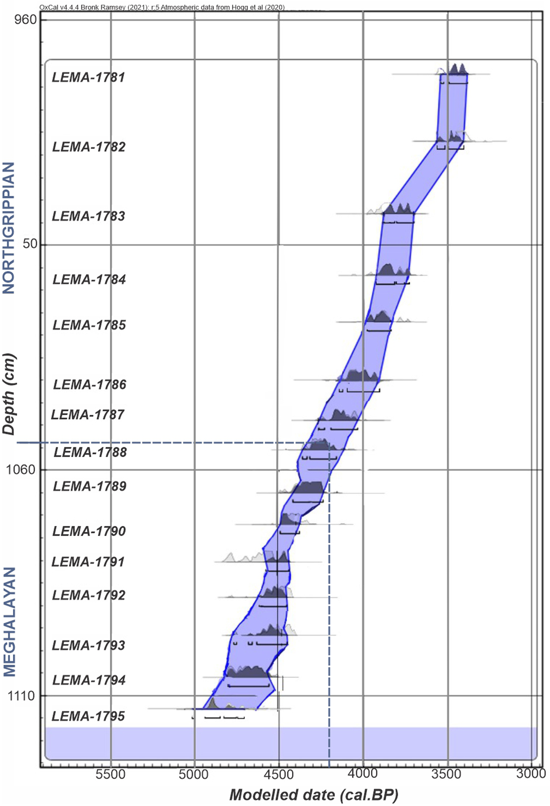
15 sediment samples of the profile were selected for radiocarbon dating (14C) by accelerator mass spectrometry (AMS), at the National Laboratory for Accelerator Mass Spectrometry (LEMA), Universidad Nacional Autónoma de México (UNAM). To date the total organic carbon (TOC), samples were treated with hydrochloric acid (0.5 M), to eliminate carbonates. Followed by rinsing with deionized water to neutral pH and finally drying at 60 °C for 24 hr. Next, they were processed to convert their carbon content into CO2 and then into graphite in an AGE 3 Automated Graphitization Equipment (Ion Plus). The 14C, 13C and 12C analysis of the graphite was carried out using a 1 MV Tandetron equipment (HVEE). Radiocarbon ages in years before present (BP) were calculated as described in Solís et al. (Reference Solís, Chávez-Lomelí, Ortiz, Huerta, Andrade and Barrios2014). A sequential deposition model (P_sequence) was used with chronometric data and the stratigraphic information. The model was constructed using OxCal 4.4.4 and the SHCal20 calibration curve with 2 sigma. The 95.4% confidence intervals of the modeled dates indicate a margin of error of 200 to 250 years (approximately).
The mineralogical information and interpretation were taken from Kulemeyer (Reference Kulemeyer2005). 37 pollen samples were prepared using standard techniques (Faegri and Iversen Reference Faegri, Iversen, Faegri, Kaland and Krzywinski1989). A minimum of 300 pollen grains was counted per sample. Pollen types were identified using the reference collection and atlases Heusser (Reference Heusser1971) and Markgraf and D’Antoni (Reference Markgraf and D’Antoni1978).
The pollen data is presented as a percentage of the total fossil pollen sum. The zonation of the sequence was performed using a stratigraphically constrained cluster analysis, which applied the maximum likelihood hierarchical divisive method and Edwards and Cavalli-Sforza’s (Reference Edwards and Cavalli-Sforza1965) dissimilarity coefficient on standardized pollen data. This coefficient weights rare species, improving their contribution in defining the pollen zones (Grimm Reference Grimm1987). Cluster analysis is a valuable tool for examining fossil pollen sequences, helping to identify groups of samples with similar pollen composition and reveal patterns in past vegetation and climate change (Valentine and Peddicord Reference Valentine and Peddicord1967). The diagrams and calculations were performed with the Tilia 2.0.2 and CONISS programs (Grimm Reference Grimm2004). To assess the environmental conditions, we used pollen indices, which are based on pollen types with known environmental responses for the Andean region. Poaceae and Asteraceae are local sources that can be used as indicators of soil moisture in summer (Liu et al. Reference Liu, Reese and Thompson2005; Torres et al. Reference Torres, Lupo and Pérez2023). Applying a logarithm to the Poaceae/Asteraceae ratio helps normalize the data, especially when dealing with very high or low values, making it easier to interpret the trends.
Results
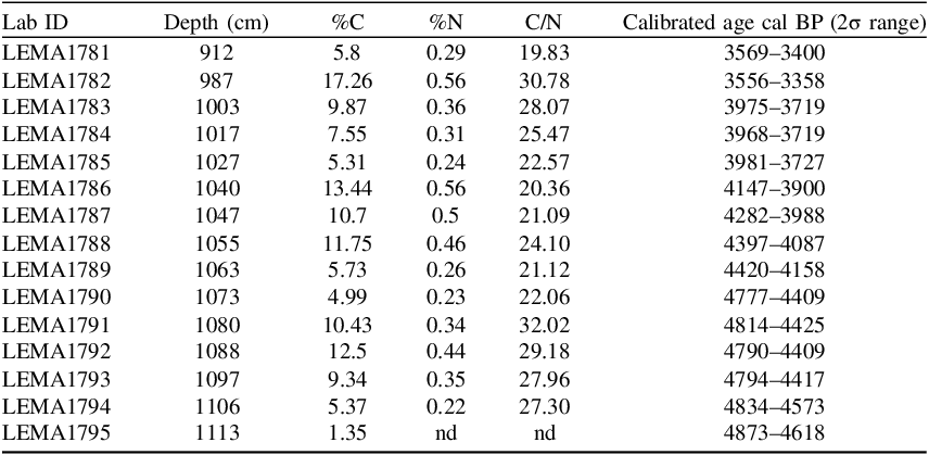
An age-depth model was also built (Figure 2). C/N ratio was used to infer the origin and verify that the material was terrestrial. The assumed C/N ratios for the terrestrial end members range from 14.8 to 45 (Perdue and Koprivnjak Reference Perdue and Koprivnjak2007). The values obtained range between 20 and 32, with an average of 25 (Table 1). Modeled output estimates that the archive spans 4750–3350 calibrated years before present (cal BP). Ranges are given at 95.4% probability encompassing the N-M boundary (4200 cal BP). In Figure 2, the N-M boundary was marked at a depth of 1053 cm (4200 cal BP).
Age-depth model of the La Falda section based on 15 radiocarbon dated samples.

AMS 14C dating results of 15 dated samples. The ages correspond to the total organic carbon (TOC) fraction.

Table 1 Long description
A table with 15 rows and 6 columns presents AMS 14C dating results. The columns are labeled Lab ID, Depth (cm), %C, %N, C/N, and Calibrated age cal BP (2σ range). Each row corresponds to a different sample. The Depth column ranges from 912 to 1113 centimeters. The %C column shows carbon percentages from 1.35 to 17.26 percent. The %N column shows nitrogen percentages from 0.22 to 0.56 percent. The C/N column shows ratios from 19.83 to 32.02. The Calibrated age cal BP (2σ range) column provides age ranges in calibrated years before present, spanning from 3569-3400 to 4873-4618. Notable trends include varying carbon and nitrogen percentages across different depths, with corresponding changes in C/N ratios and calibrated age ranges.
The sedimentary deposit is composed mainly of brownish silts, with yellowish and black levels. Two fine sand layers were identified, located between 974–990 cm and 1096–1106 cm, interbedded within finer-grained units. The silty horizons frequently exhibit fine laminations, along with abundant charcoal fragments, plant macroremains (including burnt leaves), and Fe-oxide mottles. The stratigraphy reveals a pattern of alternation between organic accumulation and combustion events, as indicated by the recurrence of dark laminae rich in carbonized material.
Stratigraphy and fossil pollen assemblages
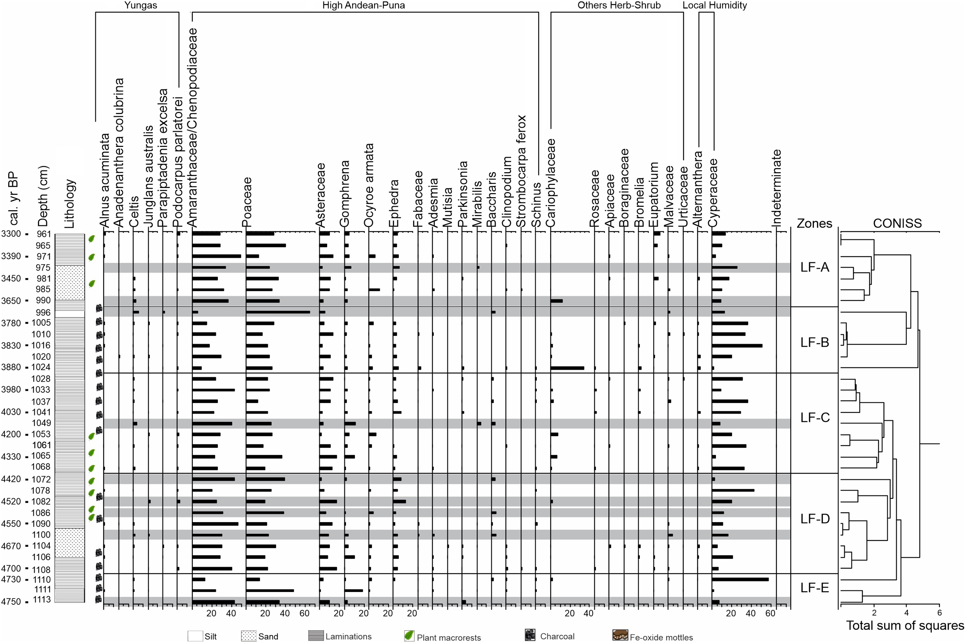
The cluster analysis of La Falda-section (Figure 3) sort out the pollen sequence into 5 zones:
Fossil pollen diagram of the percentage of the main taxa of La Falda and sequence zonation. Levels marked with grey lines indicated samples with low pollen content (<70 grains per sample).

Zone LF-E (4750–4730 cal BP): Maximum contributions of Gomphrena (18.8%). Among the tree species of the region, low proportions of Schinus are observed (<2%). Cyperaceae reaches 57.2%. The zone is characterized by the presence of massive silts, with low organic matter content and the presence of lamination of millimetric scale, in which dark organic and whitish clastic sediments alternate.
Zone LF-D (4730–4400 cal yr BP): The highest numbers of samples with low pollen content were found in this zone. However, in the samples that preserved pollen it was observed that the predominance of Poaceae and Amaranthaceae/Chenopodiaceae continues. It is common to find strata with fine lamination, in which dark levels, rich in organic carbon and charcoal, alternate with lighter, silty ones. These alternate with massive silts. Occasional mottling is also present, indicating post-depositional processes. Plant macrorests (mainly Poaceae and Cyperaceae) are frequently present, which are sometimes charred. Between 4680 and 4560 yr cal BP, there is a layer of fine, massive sand.
Zone LF-C (4400–3900 cal yr BP): Poaceae and Amaranthaceae/Chenopodiaceae are maintained in high percentages (between 20% and 40%). Higher content of Asteraceae (up to 16%). Little or no contribution of pollen from high Andean/Puna plants. Cyperaceae percentages range between 8% and 35%. At the base of the zone, laminated sediments predominate, with similar characteristics to those described in zones E and D, associated with plant macrofossils; from 4200 cal yr BP onwards, massive silts dominate and a higher concentration of charcoal is found.
Zone LF-B (3900–3700 cal yr BP): Lower pollen content of Poaceae varying between 16.2% and 25.5% and Amaranthaceae/Chenopodiaceae between 3.6% and 29.3%. Ephedra is found around 5%. Among the Herbs/Shrubs, Caryophyllaceae reaches a maximum of 33.6%. Local moisture indicators (Cyperaceae), reach 35.7%. It is again characterized by the predominance of lamination, with the presence of abundant charcoal remains.
Zone LF-A (3700–3350 cal yr BP): Predominantly Poaceae (19–39.2%) and Amaranthaceae/Chenopodiaceae (20–42.1%). Low content of Cyperaceae (3–15%). Slight increases in Eupatorium (6.2%). Predominantly silts, with laminated structure at the base and massive at the top. Between 3600 and 3440 cal yr BP, there is a layer of fine, massive sand, with mottling at the end of its accumulation. The presence of plant macrofossils (mainly Poaceae and Cyperaceae) is frequent.
In all zones there is little pollen contribution from Yungas tree species (<6%), represented by Alnus, Podocarpus, Celtis, Juglans, Anadenanthera and Parapiptadenia.
Variations in sedimentation rate, organic matter and Poaceae–Asteraceae relationships
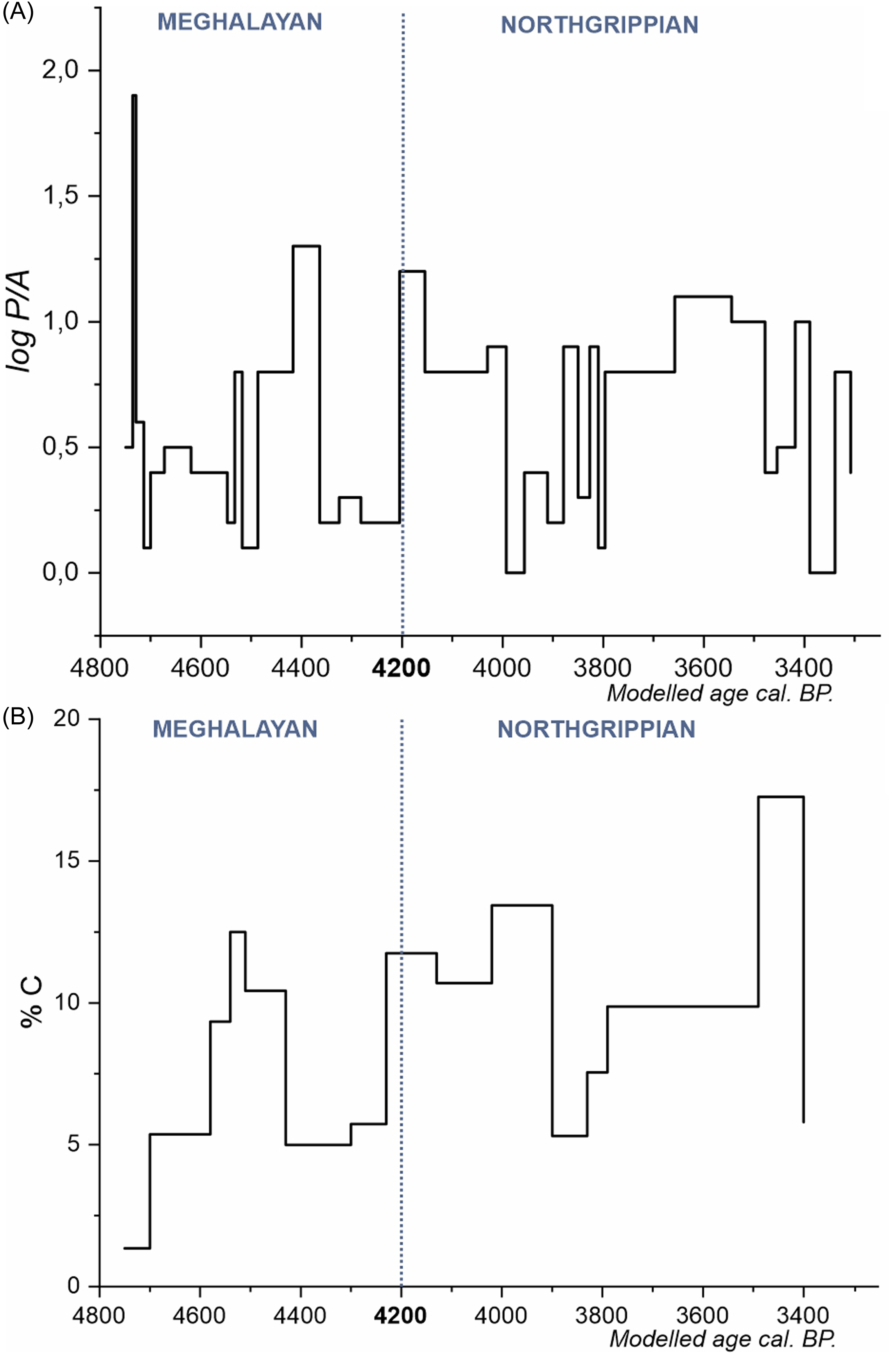
Falda’s geochronological sequence aligns closely with the stratigraphic data. Figure 4A, presents the logarithmic ratio of Poaceae and Asteraceae content (see Figure 3), used as a moisture indicator, in which, the positive values represent moments of higher moisture and the negative, dry conditions; after an initial peak of high Poaceae content, a great variability in this ratio is observed, with a slight tendency to decrease the positive values. On the contrary, Figure 4B, which represents the organic carbon content in percentage, also shows variations along the studied sequence, but with an increasing trend throughout the studied period, reaching maximum values of 17.26% (Table 1).
Poaceae/Asteraceae ratio with a decreasing trend (A), contrary to the behavior of organic Carbon, which tends to increase (B).

Discussion
The analyses carried out enabled the first detailed reconstruction of the 4.2 ka event in the Puna of Jujuy, developing a robust age-depth model based on observed sedimentary processes. The sedimentary sequence is composed of fine-grained deposits, indicating an accumulation dynamic dominated by low-energy fluvial processes (Miall Reference Miall2006). The absence of coarse sediments and the lack of evidence for erosion suggest stable sedimentary conditions, which could be associated with wetland environments (Nichols Reference Nichols2009). This interpretation would be consistent with the clustering of the 15 radiocarbon dates and their results.
The potential reservoir effect that may be present in the analyzed samples has been previously considered in the region. Vignoni et al. (Reference Vignoni, Córdoba, Tjallingii, Santamans, Lupo and Brauer2023), who studied a lacustrine system, concluded that the main influences on radiocarbon ages are related to inputs of thermal waters, whereas modern terrestrial vegetation located outside the waterbody and away from thermal springs yielded modern ages, with no evidence of incorporation of old carbon.
In our case, carbonate dissolution can only be regarded as a minor source of 14C-free carbon, due to the predominance of siliciclastic rocks in the catchment, even when considering regional-scale eolian inputs (Coira et al. Reference Coira, Zappettini and Ferpozzi2008; Kulemeyer Reference Kulemeyer2005). Furthermore, no geothermal sources are recorded in the study area, which—together with the arid conditions and other environmental factors—preliminarily limits the likelihood of significant contributions of old carbon. Nevertheless, additional studies are considered necessary to more accurately determine the potential incidence of the reservoir effect in different types of samples and environmental settings within the study area.
Along the LF profile, charred plant macrorests were identified, suggesting fire events. González et al. (Reference González, Lara, Urrutia and Bosnich2011) indicate that rainy years favor vegetation growth and that during dry periods, vegetation is converted into biomass available for burning. The carbon levels can help to identify moisture conditions with marked seasonality or strong inter-annual variations in precipitation and temperature (Veit Reference Veit1996).
The prevalence of silty sediments in the LF profile reflects aeolian inputs in wetlands under dry regional conditions (Hooper et al. Reference Hooper, Marx, May, Lupo, Kulemeyer, Pereira, Seki, Heijnis, Child, Gadd and Zawadzki2020; Kulemeyer Reference Kulemeyer2005), as was also observed in palaeo-wetlands in the province of Jujuy, for example, in Antumpa (Cortés Reference Cortés2013) and in the headwaters of the Río Grande (Fernández Reference Fernández1984). At present, during the dry season (April to November), intense WNW-ESE winds are frequent, along with landforms of accumulation and wind erosion associated with this dominant direction.
Archaeological remains are very scarce in the area around the profile for the period studied, so it is presumed that human activities did not have a relevant impact on vegetation cover and morphodynamics, as observed from 2000 yr BP onwards (Kulemeyer Reference Kulemeyer2005). This is consistent with the generally stable conditions prevailing in the palaeo-wetland, reflected in the relative homogeneity of the sedimentary deposit, the few alterations in the accumulation rate, and the overall composition of the fossil pollen assemblages. However, the recurrent presence of charcoal in most of the profile, along with pollen associations potentially linked to pastoral activities, necessitates expanding archaeological knowledge of the environmental setting during this transition to sedentism and Agro-ceramic cultures.
Palaeoenvironmental interpretation of La Falda record
The LF sedimentary and fossil pollen record allows us to reconstruct the landscape history of the study area between 4750 and 3350 cal yr BP at a centennial scale. In all zones of the sequence, Poaceae pollen contributions are recorded in percentages like those observed in the superficial deposits that usually represent the Puna grasslands of the region (Lupo Reference Lupo1998; Lupo et al. Reference Lupo, Kulemeyer, Sánchez, Pereira and Cortés2015, Reference Lupo, Kulemeyer, Torres, Oxman, Schittek, Grau, Babot, Izquierdo and Grau2018a; Torres et al. Reference Torres, Fierro, Sánchez and Lupo2019). This evidence allows us to infer that the landscape configuration during the time studied (ca. 1400 years) maintained the physiognomy of a grassland composed of Poaceae clumps accompanied by shrub species, particularly Asteraceae. Also, Poaceae pollen contributions suggest that the development of the landscape was favored by the prevalence of an environment with soil moisture availability (Liu et al. Reference Liu, Reese and Thompson2005), as the water supply from summer rains persisted even during the dry winter period.
In the Andean region, marshes, also known as bofedales, are characterized by specific plant communities adapted to high-altitude wetlands. Key species include various grasses, sedges, and herbs, with some communities dominated by Carex gayana (Cyperaceae) that often form a dense cover (Squeo et al. Reference Squeo, Warner, Aravena and Espinoza2006). Therefore, the pollen contribution of Cyperaceae and Alternanthera indicates variations in local humidity conditions. Together with the contribution of pollen from other herbs/shrubs (Caryophyllaceae, Apiaceae, Bromelia), this allows us to characterize the development of a wetland with marsh-like characteristics (Schittek et al. Reference Schittek, Kock, Lücke, Hense, Ohlendorf, Kulemeyer, Lupo and Schäbitz2016). Regarding the high percentages of Amaranthaceae-Chenopodiaceae and Gomphrena pollen throughout the record, there is evidence from different regions of the Andes, which suggests that the presence of these taxa may be linked to the effect of herbivory by wild camelid populations such as Guanacos and Vicuñas (Lupo et al. Reference Lupo, Torres, Fierro, Oxman, Sánchez, Pereira and Schittek2018b; Petrigh et al. Reference Petrigh, Velázquez, Fugassa, Burry, Mondini and Korstanje2021). Therefore, we interpret the Amaranthaceae-Chenopodiaceae content as indicating the spread of Amaranthus sp or Chenopodium sp plants because of the permanent use of the wetland as a watering place. Another important aspect of the record is that levels with low pollen content were found, especially between 4700 and 4420 cal yr BP. Observations of plant macro debris in these levels revealed charred material, suggesting that the low pollen content is possibly due to fire events. Fire can significantly impact the presence and distribution of pollen in sedimentary sequences by altering vegetation patterns, changing pollen production and dispersal, and potentially burning and destroying pollen grains directly through combustion, which reduces their abundance in the sediments (Williams et al. Reference Williams, Shuman, Whitmore, Smol, Birks and Last2011).
Hooper et al. (Reference Hooper, Marx, May, Lupo, Kulemeyer, Pereira, Seki, Heijnis, Child, Gadd and Zawadzki2020) indicate that the drier conditions between 4200 and 2600 cal yr BP suggest the SASM was less effective over the Puna, either due to reduced monsoon activity or a northward displacement of the system during this period. However, Kulemeyer (Reference Kulemeyer2005), based on heavy mineral analyses, reports a peak in chlorite content in the sediments of the study area, which is interpreted as a brief flooding episode with a low accumulation rate, occurring between 3800 and 3490 cal yr BP. There is also no clear evidence of this 4.2 event in other records in the region, for example, in the Bolivian lowlands (Plumpton et al Reference Plumpton, Whitney and Mayle2019), in the highlands of the southern Peruvian Andes (Schittek et al. Reference Schittek, Forbriger, Mächtle, Schäbitz, Wennrich, Reindel and Eitel2015), and in the Atacama Desert (de Porras et al. Reference De Porras, Maldonado, De Pol-Holz, Latorre and Betancourt2017). It can therefore be assumed that this is a region-wide pattern
Conclusions
Palaeoenvironmental conditions near the 4.2 ka event in northern Puna of Jujuy, Argentina, have been established using geo- and bioindicators, based on a robust depth-age model, between 4750 cal BP and 3350 cal yr BP.
The landscape was characterized by grassland composed of Poaceae clumps, accompanied by shrub species, particularly Asteraceae, which were favored by the prevalence of wet soil conditions. The climate exhibited predominantly semi-arid conditions, with a slight decrease in humidity during the studied period. No evidence of significant palaeoenvironmental and/or palaeoclimatic variability was found that could be associated with the 4200 cal yr BP event. This would suggest that SASM activity over the Puna was reduced or that the monsoon shifted further north. Only around 3800 cal yr BP is a moderately significant alluvial event recorded at LF, with no evident socio-environmental implications.
This study contributes new perspectives for future Holocene research in the region and provides a local framework for upcoming multiproxy analyses aimed at better understanding how global climatic events—such as the 4.2 ka event—were expressed at the regional scale, and their possible links or influences on environmental and cultural changes in the Central Andes of South America.
Acknowledgments
We are grateful to A. Huerta and S. Martínez (LEMA-UNAM) for their support in laboratory work. To Natalia Batallanos (INECOA-CONICET), for her support in the processing of pollen samples in the laboratory. To Joaquín Julián (SECTER-UNJu) and Ing. Alex Müller, RIP (InDyA-CONICET), for their collaborations in field work. To the following projects for their financial support: PUE 22920170100027CO (INECOA-CONICET), SECTER UNJu A/0222, SECTER UNJu. A/0196, PIP CONICET 11220200100408CO, PIUNT 80020220100027TU CX E752. We sincerely thank both anonymous reviewers for their thoughtful suggestions, which have helped us improve the clarity and rigor of our manuscript.