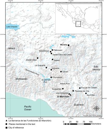
In this article, we investigate and document copper-smelting activities at the archaeological settlement of La Barranca de Las Fundiciones del Manchón in Guerrero, Mexico (El Manchón; Figure 1). People lived at El Manchón from cal AD 1240–1680 and smelted copper ore from at least cal AD 1630–1825 and likely earlier. Until now evidence for copper smelting in western Mesoamerica during this period has been scant and confusing, although we have substantial evidence concerning Mesoamerica's technically complex metallurgy (Dewan and Hosler Reference Dewan and Hosler2008; Hosler Reference Hosler1986, Reference Hosler1988a, Reference Hosler1988b, Reference Hosler1994, Reference Hosler1995, Reference Hosler1996; Meighan Reference Meighan1969, Reference Meighan1976; Mountjoy Reference Mountjoy, Charles Kelley and Riley1969; Pendergast Reference Pendergast1962) and its South American origins. Archaeological information from metallic ore extraction (smelting) sites is nevertheless rare. These processes constitute critical data in reconstructing ore extraction in any ancient metallurgy. Two smelting sites in central Michoacán—Itziparátzico (Maldonado and Rehren Reference Maldonado and Rehren2009; Maldonado et al. Reference Maldonado, Rehren, Howell, Vandiver, Mass and Murray2005) and Jicalán El Viejo (Roskamp and Retíz Reference Roskamp, Retíz, Simmons and Shugar2013)—have been test excavated, but difficulties persist at both sites in disentangling prehispanic from Colonial smelting activities. Unfortunately, radiocarbon dates are unavailable for Itziparátzico (Punzo Díaz et al. Reference Punzo Díaz, Morales and Goguitchaichvili2015).
Map of west Mexico including places mentioned in the text. (Color online)

The archaeological data concerning our investigations at the El Manchón site between 2001 and 2006 are archived in reports to Mexico's National Council on Anthropology and History (Hosler Reference Hosler2000, Reference Hosler2005a, Reference Hosler2012, Reference Hosler2018). Our research is further enriched by historical data on copper production in New Spain drawn from archives in Portugal, Spain, and Mexico (García Zaldúa Reference García Zaldúa2019).
These complementary datasets, which include 36 accelerator mass spectrometry (AMS) dates from El Manchón analyzed using Bayesian statistics, demonstrate how copper production technology developed and changed at this archaeological settlement during a period of some 200 years (~AD 1600–1825). This represents a minimum span of occupation. All uncalibrated and calibrated radiocarbon dates are available in Supplemental Table 1, whereas the sector-by-sector calibrated radiocarbon curves are presented in Supplemental Figures 1–5. What makes this study exceptional is that we document how peoples in this region of western Mexico produced one particular material, copper metal, in consistently large volumes. They did so in socially chaotic times, concomitant with the Spanish invasion and beyond, when political and economic realities changed drastically. The historical documents reveal that the Spanish invaders needed copper badly for artillery but did not know how to smelt copper ore (García Zaldúa Reference García Zaldúa2019). As a result, for at least one century and likely for two, Spaniards were dependent on indigenous west Mexican specialists—miners, furnace builders, and furnace operators—and were forced to negotiate with them to obtain copper metal. The west Mexicans had already developed the technical know-how to smelt these metallic ores. What changed dramatically was the scale of copper production, made possible by the introduction of European bellows. Nevertheless, copper production remained in the hands of indigenous specialists.
Our intention in this contribution is to provide archaeological data from El Manchón, which we argue is a colonial copper ore smelting site with indigenous antecedents, and to provide historical data that support our archaeological interpretation. We are therefore able to document changes in copper production technology using four independent lines of evidence: history, materials engineering analysis, and archaeological and ethnographic information.
A Brief History of Prehispanic Mesoamerican Metallurgy
Metal appeared in the history of Mesoamerica around AD 700, and this in itself is surprising. Metallurgy in all other primary nonindustrial states (e.g., China, the Andes, and the Near East), developed early in the histories of those civilizations, whereas the great Mesoamerican polities—Teotihuacán, the Lowland Maya, and Oaxaca—managed the properties of other materials in Mesoamerica's resource-rich environments. Significant facets of Mesoamerican metallurgy had roots in South and Central America (Dewan and Hosler Reference Dewan and Hosler2008; Hosler Reference Hosler1988a, Reference Hosler1988b, Reference Hosler1994) where the earliest evidence for hammered gold sheet occurs prior to the Chavín horizon, around 2155–1090 BC (Aldenderfer et al. Reference Aldenderfer, Craig, Speakman and Popelka-Filcoff2008; Burger and Gordon Reference Burger and Gordon1998; Grossman Reference Grossman2013; Lechtman Reference Lechtman, Roberts and Thornton2014).
Facets of Mesoamerican metallurgy—encompassing knowledge of ore-smelting techniques, some casting and sheet-forming methods, and a few prototype artifacts—were introduced from north coastal Andean South America via maritime trade to datable archaeological settlements in the mineral-rich region of western Mexico. This region corresponds to the modern states of Guerrero, Michoacán, Colima, Jalisco, and Nayarit (Dewan and Hosler Reference Dewan and Hosler2008; Hosler Reference Hosler1986, Reference Hosler1988b, Reference Hosler1994, Reference Hosler1996). The body of information introduced likely encompassed the knowledge of copper ore types. Before AD 1100 most objects were fashioned from copper; after AD 1100 copper alloys became common and included copper-tin (Cu-Sn), copper-arsenic (Cu-As), copper-silver (Cu-Ag), and gold-copper (Au-Cu), as well as various silvering and gilding techniques and artifact designs. Hosler (Reference Hosler1986, Reference Hosler1994) identified similarities by comparing materials, methods, and design attributes of the west Mexican metal corpus with earlier South American examples. Archaeological/laboratory-analytical methods and ethnographic, ethnohistorical, and linguistic sources provided clues to the social interpretation of the new material—metal—and how west Mexican peoples perceived it.
As noted elsewhere, these west Mexican peoples were interested in metal for its properties of color and sound (Hosler Reference Hosler1986, Reference Hosler1995, Reference Hosler2005b), so that bronze alloys containing tin in concentrations above 5wt% looked golden, whereas silver-copper alloys and high-arsenic copper-arsenic alloys appeared silvery. In Mesoamerica, the colors and sounds introduced by these metals, their alloys, and the objects made from them were considered sacred and powerful. Their sacred power inhered in the metal itself and was transmitted to and by the individuals who wore and used it (Hosler Reference Hosler1994). In fact, ethnohistorical sources—for example, the Relación de Ajuchitlán, Guerrero (Acuña Reference Acuña1987)—record an origin myth in which god found metal to be the most appropriate material from which to make the first human beings, and that the first human beings were cast from ash and certain metals (Hosler Reference Hosler1986, Reference Hosler1994, Reference Hosler2005b). We know that the brilliant, shimmering colors of gold, silver, and their alloys represent colors of deities—the sun and the moon—and of a sacred paradise (Hosler Reference Hosler1994, Reference Hosler1996).
One of the striking aspects of this west Mexican technology was the rapid spread of the technical knowledge required to smelt complex ores, especially after AD 1100, and to produce copper-based alloys. El Manchón provides an example of notable technical achievements, specifically in smelting. Elsewhere, metalworkers managed complex technical undertakings in copper-based alloy production, and in particular silver-copper bell alloy castings and bell castings made from tin bronze (Hannahs et al. Reference Hannahs, Tarkanian and Hosler2018). These activities required knowledge, that is, the choice of appropriate clays for the mold design and command of the physical and mechanical properties of the Ag-Cu and Cu-Sn alloy systems, including the ranges of their melting and solidification temperatures. Casting a 10wt% tin bronze bell is a singular metallurgical feat (using modern commercial potters’ clays). The pottery clay mold begins to vitrify at about 1050°C, which is close to the melting point of the bronze alloy (1010°C; Hannahs et al. Reference Hannahs, Tarkanian and Hosler2018). Data are unavailable for vitrification temperatures for molds made from clays used by ancient west Mexican potters.
El Manchón: Context and Environment
Hosler located El Manchón (Figure 1) in the course of a metalworking site survey in Guerrero during 1998–1999 (Hosler Reference Hosler2000, Reference Hosler, Niederberger and Robles2002; Lopez et al. Reference Lopez, Hosler, Pantoja, Martini and Morales1999). The survey focused on the Guerrero side of the Balsas River, the area between Coyuca de Catalán, Placeres de Oro, and Guayameo. The likelihood of locating ancient metal production sites was considered greater there than in Michoacán, given the presence of massive sulfide ore bodies at Inguarán, Cocián, and other sites (Hosler Reference Hosler1994, Reference Hosler, Niederberger and Robles2002), each of which had a long history of commercial exploitation. The survey identified six settlements that exhibited slag (Hosler Reference Hosler, Niederberger and Robles2002). All settlements were located within 1 km of undocumented small copper deposits (Lopez et al. Reference Lopez, Hosler, Pantoja, Martini and Morales1999). All but two of these sites also exhibited strong evidence of colonial activities, in particular colonial pottery.
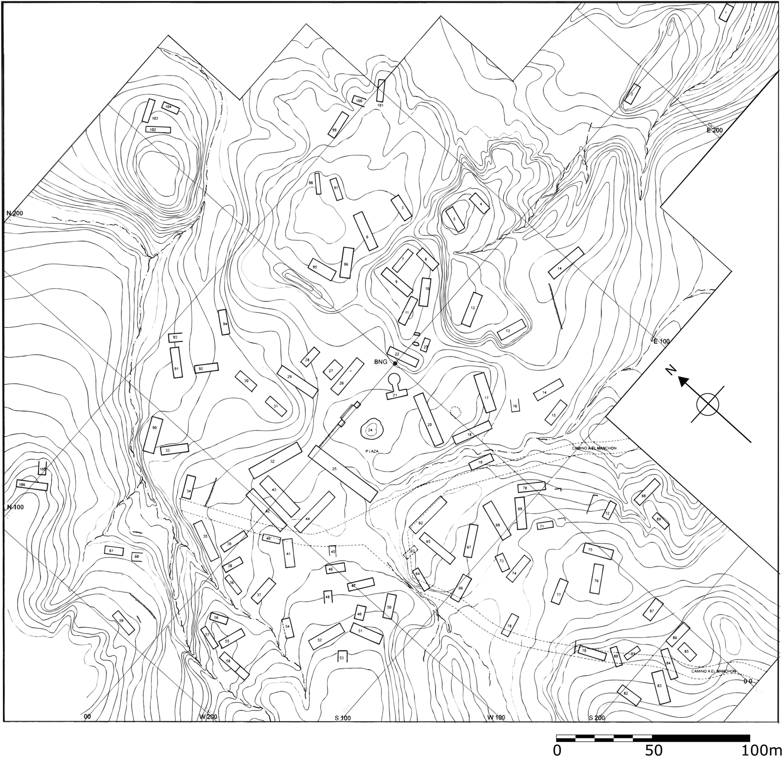
Hosler decided to survey and excavate El Manchón, because the site is large (the maximum length of the site measures about 700 m; Figure 2), is located in a pine-oak forest, and exhibits numerous prehispanic structures. Sherds, lithic artifacts, and architectural features suggested that the settlement was prehispanic. A depleted mine containing both malachite and azurite mineral lies 1,000 m upslope from the site. Surface slag accumulations were voluminous. This constellation of features was consistent with prehispanic metallurgical activities. El Manchón lies within 1.5 km of Los Cimientos (Figure 3), a much larger and architecturally far denser site, located in an adjacent well-watered valley where people cultivate maize, beans, and other crops. Los Cimientos exhibits architectural forms identical to those of El Manchón, but the site lacks slag.
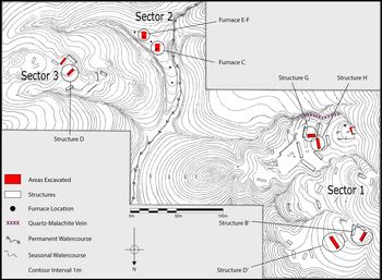
Topographic map of the site Barranca de las Fundiciones del Manchón showing the three sectors, schematic areas excavated, and quartz-malachite vein (drawn by Carlos Santos Rodriguez and edited by Johan García Zaldúa and Jennifer Meanwell). (Color online)

Topographic map of the site of Los Cimientos showing all structures (drawn by Carlos Santos Rodriguez).

The two settlements are located in the physiographic province of the Sierra Madre del Sur and, more specifically, in the subprovince of the Southern Coastal Range. In this zone elevations range from 340 masl in the Balsas Depression to the highest mountain elevations, where some peaks reach 3,000 masl or higher. The altitude of the area encompassing these two sites ranges from 1,200 masl (Los Cimientos) to 1,350 masl (El Manchón).
The study area comprises a biotic zone that is transitional from the lowest to the highest altitudes of the Cordillera. Vegetation consists of mixed stands of pine and oak. Between 1,100 and 1,300 masl, oak is predominant; mixed pine and oak characterize the region between 1,300 and 1,700 masl; above 1,750 masl, pine predominates. The climate at 1,300–1,700 masl is subhumid and temperate. This means that annual rainfall in this area ranges from 700 to 900 mm; the rainy season stretches from June to September. Maximum rainfall occurs in July, and February is the driest month of the year.
The site of El Manchón is located in a canyon that runs south to north, where the narrow topography gives way to broader and more open terrain (Figure 2). The canyon is known as the Barranca de Las Fundiciones, and the permanent stream that flows through it as the Arroyo de Las Fundiciones. The water flows down from a spring originating at the upper (south) end of the canyon, some 3 km upstream from the archaeological site. El Manchón was excavated in three field seasons between 2001 and 2006. We could not return after 2006; this region of the Sierra Madre of Guerrero is now prime territory for marijuana and poppy production and is managed by groups engaged in that activity. Our work there is likely the last in this region for many decades.
El Manchón is divided topographically into three sectors that correspond also to three distinct archaeological sectors, as Figure 2 indicates. Sectors 1 and 3 exhibit surface architectural remains, prehispanic pottery, and lithic artifacts. By contrast, Sector 2 lacks surface architectural remains, but El Manchón demonstrates unambiguous evidence for metallic ore smelting. This evidence consists of what were likely furnaces, visible now as clusters or arrangements of burnt stones, and voluminous amounts of slag, copper ore, and undiagnostic pottery.
We carried out laboratory analytical studies of ore, slag, and pottery samples from El Manchón at the Center for Materials Research in Archaeology and Ethnology at the Massachusetts Institute of Technology (MIT). The archaeological materials collected at the site are housed at the Colegio Mexiquense, Zinacantepec, Estado de México.
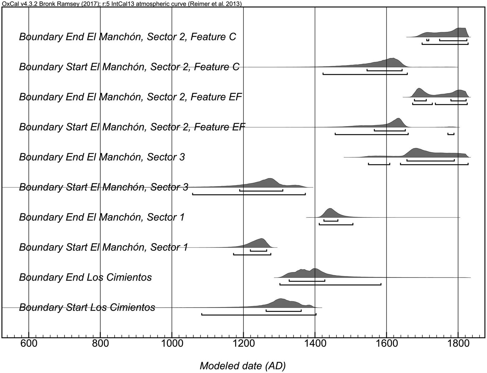
The excavations at El Manchón produced a suite of 36 AMS radiocarbon dates, which are further supported by an additional three dates from the nearby site of Los Cimientos. To establish the period(s) of occupation for Los Cimientos and for each sector of the site, we analyzed the suite of radiocarbon dates with Bayesian statistical methods, using the program Oxcal 4.3 (Bronk Ramsey Reference Bronk Ramsey2009). The 14C dates were calibrated using the IntCal13 Northern Hemisphere curve (Reimer et al. Reference Reimer, Bard, Bayliss, Warren Beck, Blackwell, Ramsey, Buck, Cheng, Lawrence Edwards and Friedrich2013). Many of the dates have multiple, approximately equal probability intercepts, making this Bayesian method particularly useful in their interpretation. Due to the spatial separation between sectors, each sector and Los Cimientos were modeled as chronologically independent. Additionally, the dates for each sector of the site were modeled as being fully independent of each other, given the general lack of clear stratigraphic relationships among dates. Figure 4 shows the resulting probability curves for the most likely beginning and end dates for the occupation of each sector and for Los Cimientos. Based on the highest probability start and end dates, Sector 1 was occupied before the Spanish invasion (cal AD 1250–1440), and Sector 2, the smelting area, dates to cal AD 1630–1825. The AD 1825 cutoff is based on discussions with the most senior individual in the village who, at the age of 78, recalled that when his great-grandfather lived in El Manchón, there was no smelting activity in process. Sector 3 encompassed both time periods (cal AD 1280–1680). Los Cimientos dates from cal AD 1300–1410. We need to emphasize that these beginning and end dates should be considered minimum spans of occupation, since only one or two of many structures or features were tested in each sector and at Los Cimientos, and both earlier and later activity may have occurred at each site. Interpretations of these ranges are discussed further in the following sections on each sector.
Bayesian probability curves for the start and end dates of occupations at El Manchón and Los Cimientos.

Physical Description and Excavations of Sector 1
Sector 1 is located on a slope that descends gradually to flatter terrain that has been used for pasture. This practice, together with the naturally occurring acidic soil and major erosion, has eradicated any natural or artificial stratigraphy throughout the sector. Commercial logging of the pine forests in the mountains above Sector 1 has created a long strip of deforested terrain above it. As a result, the platforms just above the flatter area where most Sector 1 structures are located have been nearly destroyed. The destruction through erosion continues during the rainy season, washing any surface archaeological materials downslope.
The architectural features are located in these flatter areas. Sector 1 exhibits 41 complete, rectangular structures and a number of retaining walls that, together with the structures, define plazas and terraces. These structures associate El Manchón with the architecture of Los Cimientos (Figure 3) that exhibits similar long, rectangular structures. The structures in Sector 1 measure up to 22 m in length, 3 m in width, and 2 m in height. Most look like rectangular mounds or occasionally like simple stone alignments, suggesting a rectangular structure that served as a house foundation.
We surveyed and excavated five structures in Sector 1. Excavated areas are indicated in Figure 2. We carried out a complete horizontal excavation of structure G together with trenches leading to the structure; we also dug trenches to the base of Structure H, a grid to the base of Structure B’ and a trench across it, and a grid on the southwest side of Structure D’. We dug test pits within structures D’ and B’. We were unable to place any of the material found in the test pits in a stratigraphic sequence. The stratigraphy outside of most structures is practically nonexistent, generally consisting of a single 10–20 cm level. The level below this consists of disintegrating fragments of bedrock (known locally as tepetate). The stratigraphy within the structures is generally homogeneous, composed of an initial level some 10–15 cm thick.
Cultural material recovered from the 10–20 cm level of structure G comprises numerous examples of intact quartz mineral; several quartz crystals about 1 cm in length; potsherds, including one with slag adhering to the surface; and occasional small nodules of malachite ore, some of which are intergrown with quartz. Below this level lies 60–80 cm of fill, made up of pebbles, a few pottery sherds, and sporadically distributed lithic artifacts. Bedrock lies below the fill.
Certain materials are related to copper smelting, such as the samples of malachite-quartz intergrowths, malachite nodules, and the slag adhering to the potsherd. A source for the malachite-quartz intergrowths and the malachite mineral derives from a quartz-malachite narrow vein observed along the sloping easterly edge of Sector 1 (Figure 2). The Bayesian graphs for the dates from this sector appear in Supplemental Figure 2.
Physical Description and Excavations of Sector 3
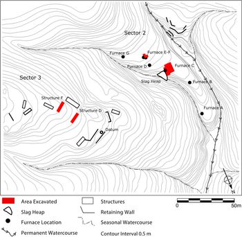
As Figures 2 and 5 indicate, Sector 3 is located along the higher reaches of a slope that descends steeply into the canyon along a southeast–northwest axis. Water flows along this arroyo only during the rainy season. The Sector 3 slope is steeper than that of Sector 1. As a result of the incline, limited areas are available for building; the long stone structures function simultaneously as features that level and contain terraces and as habitation units. This sector is therefore made up of a series of stepped terraces that use both structures and retaining walls to level the terrain and prevent erosion.
Topographic map of Sectors 2 and 3 showing the structures excavated. The furnace remains and slag heap are located in Sector 2 (drawn by Johan García Zaldúa based on the original map drafted by Carlos Santos Rodriguez). (Color online)

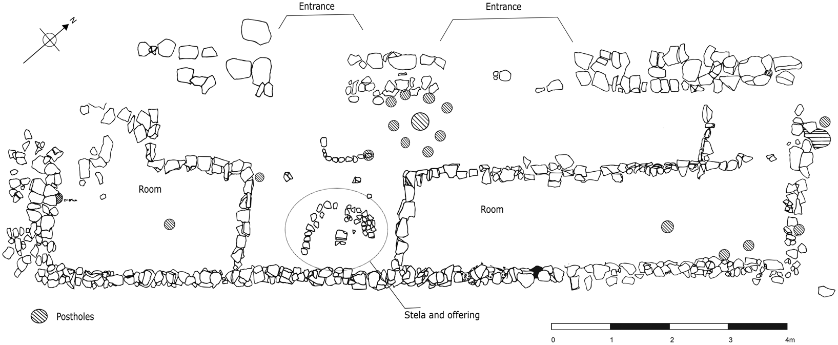
Figure 5 indicates that Sector 3 consists of nine rectangular structures, as well as retaining walls. The figure highlights the structures that were explored during excavation. In one of these, Structure D (Figure 6), a series of stones demarcate interior divisions. Structure D is flanked by Structure E to the southeast and faces Structure F directly, creating a patio-like enclosure. However, Structures E and F are, so far, undated, making the relationship between these structures unclear. Our excavations concentrated in the patio and in Structures D and F. We also excavated an L-shaped trench from structure F in the patio-like area between D, E, and F. Structure D was covered with stones, apart from those that delimit the internal divisions. Faced, rectangular stones varying in size were set at the base of the structure. The south, east, and west walls consist of simple rows of worked stone, between 20 and 40 cm high; two rows of worked stone, some 1 m high, make up the north wall.
Sector 3, plan of Structure D showing interior rooms, postholes, and the stela.

Extensive excavations of Structure D confirm the existence of interior divisions and uncovered a vertical stone stela in situ. The stela, placed approximately 50 cm from the south wall, measures 75 cm in height (Figure 6). This element was associated closely with a ceramic offering deposited some 10 cm from the base of the stela. The offering consisted of a small pottery bowl containing fragments of bone.
These data suggest that Structure D had a special role at the site associated with ritual activities that may have persisted through the last occupation of the sector. The Bayesian probability curves for this sector are reported in Supplemental Figure 2. They date the occupation from cal AD 1250–1680. This range of dates indicates that Structure D is contemporary with the some of the dated smelting activities in Sector 2, suggesting that indigenous Manchón smelting specialists were likely operating the furnaces.
Pottery from Sectors 1 and 3
We recovered little diagnostic pottery at El Manchón. The majority of the sherds (89.7% of a total of 4,278) were eroded badly. All but a few diagnostic pottery fragments were recovered in Sectors 1 and 3. Sector 2, by contrast, produced occasional nondiagnostic, eroded pottery sherds. Fortunately, we were able to reconstruct formal pottery types: tripod bowls, plain bowls, colanders, molcajetes for food processing, jars, plates, jugs, comales (griddles), and figurine fragments. These are described in detail in the report to the National Council on Archaeology and History (Hosler Reference Hosler2018) and in Supplemental Figures 6–8. Few sherds appear in stratified contexts. We excavated a deposit of sherds in Sector 1, Structure G, that also contained quartz nodules and quartz in physical association with other ore minerals: quartz with malachite, quartz with hematite, and quartz with hematite and malachite. These ore mineral associations are common in Sector 2.
Reitzel (Reference Reitzel2007) carried out laboratory analytic studies of pottery and clays from El Manchón. She demonstrated that, regardless of functional type, the pottery was made from local Manchón clays. During her fieldwork Reitzel interviewed Manchón potters, all of whom used local sources of clay. Village members identified those sources for Reitzel. In laboratory tests of these Manchón clays she determined that the properties of the clays met the requirements of various functional pottery types she had identified with respect to thermal conductivity, thermal diffusivity, thermal shock resistance, and yield strength. Although she evaluated serving dishes, storage vessels, and figurines, she focused the analysis on cooking vessels, which are prone to mechanical failure.
All pottery recovered from Sectors 1, 2, and 3 was produced on-site and represents Mesoamerican formal types. The decorative elements, by contrast, do not resemble the pottery of any reported cultural group, either in the Balsas drainage, the Balsas Depression, or elsewhere. The few sherds we collected from Los Cimientos resemble those from El Manchón. We assume that these people belonged to a social group whose identity has, until now, gone unreported.
Sector 2
Sector 2 was a copper ore smelting area, located on a moderate slope between Sectors 1 and 3 (Figures 2 and 5). On its southwest side, Sector 2 is defined by a permanent stream, Arroyo de Las Fundiciones, and on the east side by a seasonal stream. The land between the two arroyos defining Sector 2 descends gradually from the crest of the mountainous system. Trails lead from below Sector 2, through it, and up to the mountainous crest from which people and animals can descend from these valleys and intermontane canyons to the Río del Oro, the highway from Coyuca de Catalán to Zihuatanejo, and from there to the Pacific Ocean.
We defined this sector by its exclusive concentrations of items associated with copper production. A slag pile in the arroyo adjacent to Furnace C (Figure 5) constitutes the densest accumulation of slag at the site. Many Sector 2 surfaces were covered with mounds of slag, interspersed with fragments of copper ore, particularly of malachite, which were often associated with quartz, hematite, azurite, and cuprite. X-ray diffraction analysis of Sector 2 slag (Sharp Reference Sharp2003) identified chalcopyrite and wüstite. Chalcopyrite weathers to copper oxides such as malachite and azurite. Certain portions of the sector were covered with a thin film of slag that cracked like ice when we walked across it.
Sector 2 also displayed seven stone arrangements, some containing slag, worked and unworked stone, or fragments of copper ore. All of these features could have been remains of furnaces. They are identified sequentially as Furnaces A–G in Figure 5. We focused on excavations of Furnaces C, E, and F, because they were the largest and were characterized by the presence of burnt rock, slag, and copper ore. We learned that E and F constitute a single smelting operation (Furnace E–F). When all of the radiocarbon dates (Figure 4; Supplemental Figures 3 and 4) for Sector 2 undergo Bayesian analysis, they indicate a span of occupation between cal AD 1630 through the abandonment of the site, modeled at cal AD 1825. An earlier, lower-intensity use of this sector remains a possibility. When the earliest five dates (samples 155084, 193994, 194860, 193991, 194857) for the sector are modeled alone, the start of occupation for the sector shifts to cal AD 1520 (Angela Huster, personal communication 2019). These dates may represent the remnants of El Manchón's ancient indigenous smelting tradition that used blowpipes. The full range of radiocarbon dates for this furnace appear in Supplemental Table 1. Because these earliest dates are not stratigraphically or contextually separated, they likely represent the redeposition of earlier material.
Furnace C
Furnace C exhibited by far the largest concentration of surface features related to smelting. Among these is a dense concentration of worked and unworked stone mixed with quantities of slag and copper ore. The large slag pile that slid from the surface into the arroyo measures approximately 9 m along the arroyo at its deepest and is associated with this furnace (Figure 5). A pine tree grows directly in the center of the furnace. Damage caused by the extensive root system, significant and ongoing erosion of the surrounding terrain, and what we suspect was continuous use of the furnace for several hundred years made it impossible to reconstruct the original furnace design. We were able to date eight pieces of wood charcoal recovered from Furnace C (Supplemental Table 1). The Bayesian probability curves (Supplemental Figure 3) date activities at the furnace from cal AD 1630 through the abandonment of the site. This is consistent with our subsequent discussion of high-volume copper smelting mandated by the Spaniards but managed by indigenous specialists. The practice of indigenous, blowpipe copper smelting prior to this period is a reasonable possibility, as discussed subsequently.
Furnace E-F
Excavation in Sector 2 focused on the furnaces we identified as E and F, which were located 40 m to the south of Furnace C. The E-F complex is smaller than Furnace C but was better preserved, although this area, as all areas of Sector 2, was eroded. Our analysis shows that the adjacent furnaces labeled E-F may represent the remains of a single, hand-powered, circular bellows smelting operation similar to the reconstruction drawing in Figure 7.
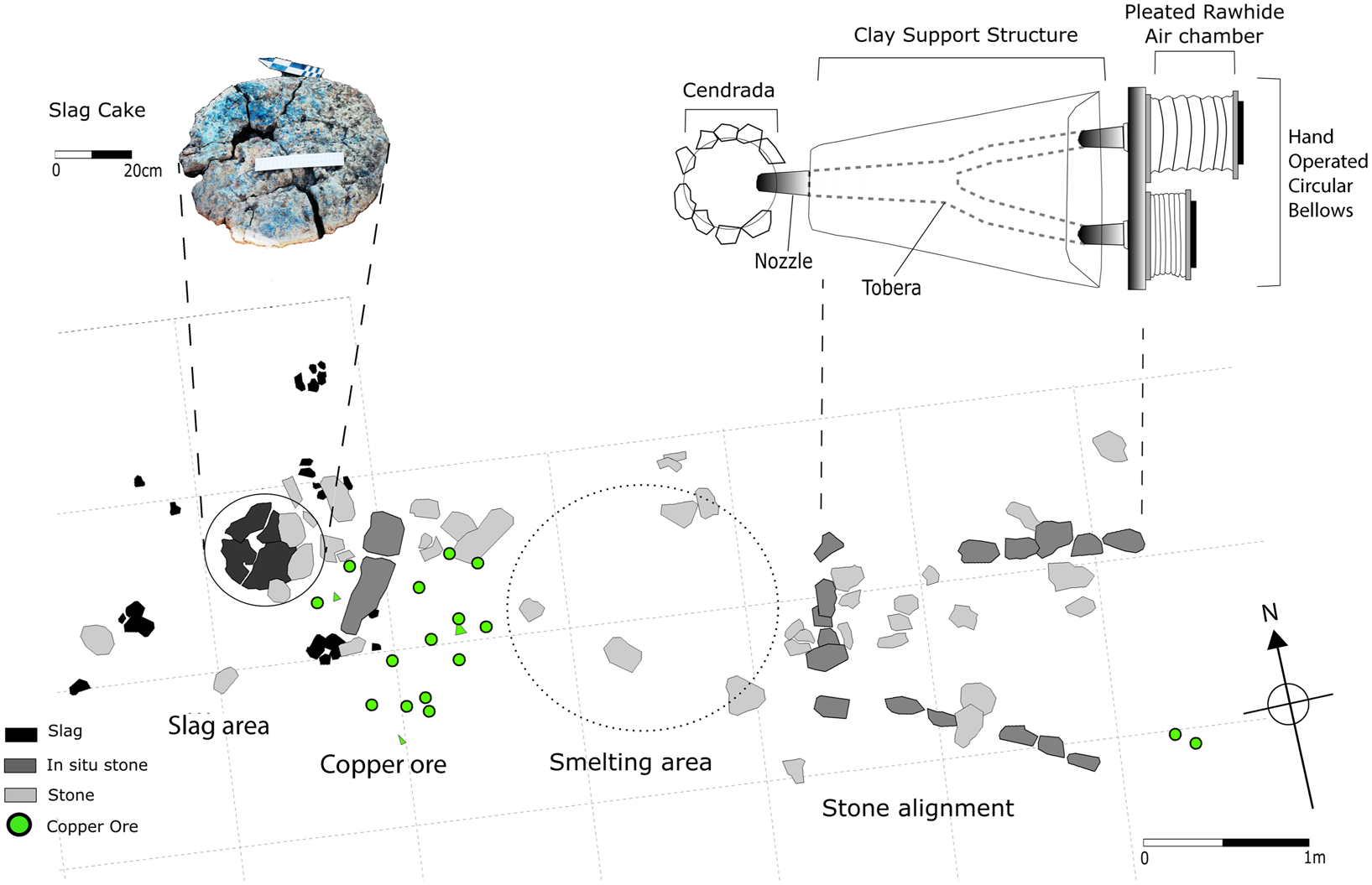
Sector 2, plan view excavation diagram of Furnace E-F, including sets of aligned stones, a collection of copper ore, and an intact slag cake located in the circled area identified as “slag area.” A photograph of the slag cake has been enlarged to a different scale and moved to the upper left. The geometry of the Furnace E-F aligned stones, together with the location and size of the slag cake, allowed the reconstruction drawing of a hand-operated circular bellows cendrada furnace, illustrated in plan view in the upper-right register above the Furnace E-F excavation diagram.

The archaeological remains of Furnace E-F consist of two in situ rows of aligned stones illustrated in Figure 7, where they are identified as “stone alignment.” The diagram also locates the adjacent surface remains of copper ore and slag waste. We recovered a large, round, thick and solid slag cake 5 cm below the surface at the diagram location indicated as the “slag area.” The slag cake, cracked but intact, measures 50 cm in diameter and is about 5 cm thick. The geometry of the cake makes clear that the slag solidified inside a furnace, and its diameter is identical to the upper diameter of such a furnace. We include an enlarged photograph (with cm scale) of the slag cake in the upper-left corner of Figure 7.
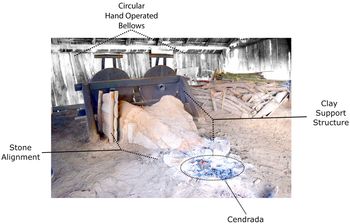
The two in situ rows of aligned stones, the copper ore remnants, and the slag cake are located linearly along an axis that runs from midway between the two rows of aligned stones, through the scattered copper ore cluster, to the middle of the slag cake location. This alignment and the sequence of archaeological features that configure it provide evidence for the reconstruction drawing of a cendrada-type, hand-powered, circular bellows copper ore smelting furnace that appears in plan view at the upper-right level of Figure 7. Such a cendrada-type smelting furnace is on display at the Taller Casa del Artesano in Santa Clara del Cobre, Michoacán, Mexico (Figure 8).
Traditional hand-operated circular bellows cendrada furnace currently displayed at the Taller Escuela Casa del Artesano, Santa Clara del Cobre, Michoacán. This furnace design was used by traditional smelters at Santa Clara until the last decade of the twentieth century (photograph courtesy of Patricia Castro and used with permission).

Rachel Sharp (Reference Sharp2003) analyzed the excavated Manchón ore and slag. Her slag analyses showed that the lowest likely furnace temperature for formation of the liquid slag is 1150°C (Sharp Reference Sharp2003:75). This temperature can neither be achieved in a simple charcoal fire nor maintained in a shallow bowl-type furnace operated with blowpipes, such as those used by Sicán metalworkers on Peru's north coast (Shimada and Merkel Reference Shimada and Merkel1991). The Manchón furnace temperature was raised by some mechanism, such as a bellows, that introduced abundant air into the furnace. No evidence exists that El Manchón metalworkers were extracting copper prills from a solid, viscous slag. The slag is intact, not crushed to powder as was necessary at the Sicán site.
The Manchón slag consists primarily of crystalline and glassy fayalite with some minor presence of tridymite. The tridymite, viscous at the furnace operating temperature, sometimes trapped tiny copper prills. The Manchón slag containing these two silica phases liquefies at about 1150°C. These results further argue for the use of a bellows to reach the required smelting temperatures. Sharp's research demonstrated that the cuprite and malachite we observed and recovered on the surface and in excavations originated from a complex iron sulfide ore in which the copper mineral was often present in a quartz matrix.
We propose that a hand-powered bellows copper smelting furnace operated at El Manchón that was capable of separating the liquid copper metal from the slag produced during a smelt. The primary evidence for the furnace design resides in the geometry and configuration of the two linear arrays of undisturbed stone that may represent portions of the furnace foundation. At Santa Clara, the stone foundation supports a clay structure (Figure 8) that contains and protects a system of fired clay toberas (tuyeres). The bellows-driven air flowed through the tobera, exiting from a nozzle located directly above a cendrada (smelting pit) charged with ore and fuel.
The reconstruction drawing in Figure 7 proposes a hand-powered, circular bellows furnace of a type that we argue was likely used at El Manchón by indigenous operators to smelt copper ore subsequent to the Spanish invasion (García Zaldúa Reference García Zaldúa2019). We know from García Zaldúa (Reference García Zaldúa2019) that in 1533, the Spaniards, in negotiations with indigenous west Mexican smelters, suggested introducing bellows to increase their production of smelted copper. The bellows furnace design presented in Figure 7 most likely derives from that negotiation. The Bayesian analysis dates for the E-F (Figure 4) indicate that major smelting operations began just before cal AD 1630 and concluded at cal AD 1825.
Archival sources cited subsequently describe a cendrada as a hole in the ground (Supplemental Text 1a, 1b). Ore smelting took place within the cendrada: molten copper migrated to the bottom, slag floated to the top. A photograph of the large, thick slag cake recovered from Furnace E-F appears in Figure 7. The slag cake provides the second feature of archaeological evidence in support of the hand-powered bellows/cendrada furnace design we propose. At the end of a smelt, the solid cake was pulled out of the cendrada and set aside; in the case illustrated in Figure 7, positioned at a distance 3 m west of the stone alignment. We note that the undisturbed archaeological features relevant to reconstruction of the E-F furnace—namely, the configuration of aligned stones, the smelting area, the cluster of mixed ore and slag, and the slag cake—are arranged linearly, following the sequence required by the furnace smelting operation.
In Sector 2 we have evidence for a colonial-style extractive metallurgical (smelting) operation carried out by indigenous smelters similar to the smelting operations we propose in Figure 7 and that are described in the historical documents. Our dates are consistent with this interpretation. Our analyses indicate that this mode of smelting took place from cal AD 1630 to abandonment of the site.
Discussion
Los Cimientos was a large, dense, agriculturally productive, well-watered valley community 1.5 km from El Manchón. El Manchón, in contrast, was built on acidic soils that currently are agriculturally unproductive without modern fertilizers. El Manchón provided ore minerals: malachite in one rocky outcrop, which was a likely source for copper ores; a narrow quartz and malachite vein in Sector 1; and other local copper deposits. El Manchón is heavily forested, supporting pine and some oak vegetation, ample fuel for copper smelting. The Arroyo de Las Fundiciones provided water year round. On the basis of the architecture, settlement pattern, and the pottery from both sites we propose, nevertheless, that these people represent an unknown cultural group who occupied these settlements at about the same time. The pottery, although conforming to Mesoamerican formal types—serving dishes, cooking pots, tripod bowls, vessels, and others—displays decorative elements for which we have been unable to locate comparative material. Our dates from Bayesian analysis of the radiocarbon dates for Los Cimientos and El Manchón indicate that these two settlements were populated at about cal AD 1250 (Figure 4). We present three dates for Los Cimientos (Supplemental Table 1), making at least one occupation contemporary with that of El Manchón. We do not know when Los Cimientos was initially occupied.
Our earliest radiocarbon dates from Sector 2 (Supplemental Table 1) are several hundred years later than the earliest dates for the beginning of the occupation of either Sector 1 or Sector 3. In Sector 2 smelting was carried out from approximately cal AD 1630 to1825. Nevertheless, the voluminous and intensive scale of the colonial period smelting activities that took place after cal AD 1630 undoubtedly destroyed significant evidence of previous activities. Our archaeological and radiocarbon data suggest that the smelting was conducted in the same locations (Furnaces C and E-F) throughout this entire period of time. Reuse of the same space for more than 400 years may account for the anomalous characteristics of this archaeological deposit, particularly for the redeposition of earlier material discussed previously.
In Sector 2, there is no evidence of stratigraphy other than a layer of about 30 cm where all the materials associated with smelting are located. This includes the radiocarbon dates recorded in Supplemental Table 1 that show how, in the same excavation unit and at almost the same level, we can identify dates that fall into the prehispanic, early colonial, and late colonial periods. The dates are accurate, but the depositional context is impossible to reconstruct.
Considering activity in all three sectors at El Manchón in the fifteenth and sixteenth centuries, Bayesian statistics (Figure 4) show that in the fifteenth century and earlier, people were living in Sectors 1 and 3. During the sixteenth century the models suggest the possibility of low-intensity copper smelting, plausibly related to the antecedent blowpipe technology. Data cited in our subsequent discussion, together with the occupation of Sector 3 through cal AD 1680 and beyond, indicate that high-volume copper smelting in Sector 2 was overseen by indigenous Sector 3 peoples. Our evidence from the pottery analyses strongly supports this contention, because all the pottery in the three sectors was made from local clays.
Archival research (García Zaldúa Reference García Zaldúa2019) documents that the Spaniards who arrived in New Spain had no knowledge of copper smelting. They were forced to rely heavily on indigenous metallurgical expertise. By the sixteenth century, no copper mines had been in operation in Spain for centuries. All copper consumed in the Iberian Peninsula was bought in its metallic form from production centers in Central Europe and Scandinavia (Sánchez Gómez Reference Sánchez Gómez1989). Spaniards in New Spain were not familiar with copper ores and lacked the knowledge and skills necessary to smelt copper ores to metallic copper.
During colonization, the Spaniards’ need for copper increased, especially for manufacturing bronze artillery and coinage, as well as domestic items such as kettles and pans. Given these circumstances, as early as 1521 Cortés had already sent word to Spain about the availability in New Spain of good quality copper and tin for casting bronze artillery and of his success in casting it (Cortés Reference Cortés and De Gayangos1806:306–307). Reports similar to his likely reached the Spanish court in the following years (Supplemental Text 1c). These documents account for the novel colonial metallurgical practices in Michoacán and Guerrero that incorporated Spanish and indigenous technology. The Spaniards suggested introducing bellows and forges. The indigenous specialists recommended using iron tools for mining. They also insisted on tax exemptions to carry out this specialized work. This is the first example of what became a pattern of political negotiation by the native peoples for economic privileges based on their exclusive knowledge of these smelting technologies. This was not only the first example of what became a pattern of political negotiations but it presages the introduction and dissemination throughout New Spain of an entirely new system of copper smelting. Our archaeological evidence at El Manchón provides a singular example: a hand-powered circular bellows furnace design solution that provided one highly successful and long-lasting technical option to increase dramatically the volume of copper production. To date, El Manchón provides the only existing archaeological example of this particular design.
The suggestions contained in the 1533 Quiroga document (cited by García Zaldúa Reference García Zaldúa2019) were not implemented until the arrival of Viceroy Antonio de Mendoza, whose orders included the defense of Tenochtitlán and the port of Veracruz. He needed artillery. With the information about copper ore deposits at hand, in 1537 he wrote to Empress Isabella requesting “the necessary officers and a knowledgeable master who knew how to mine and smelt the ores” (Archivo General de Indias [AGI], Patronato Real, 184, R.27). The empress replied to his petitions in 1538 saying, “About the artillery that you request for the port of San Joan de Ulua and the city of Mexico, you already know the need of it we have here and because I have been told that in those lands there is abundance of copper, if over there are masters who know how to make it you would arrange to make the quantity of it which is necessary” (AGI, Audiencia de México, 1088, L.3, f.75–77).
Following the advice of the empress, the colonial authorities turned their attention to the native metallurgical expertise to produce the necessary copper for artillery casting and coinage. We think that at El Manchón indigenous smelters were producing copper prior to the invasion in Sector 2. The start date (cal AD 1520)—prior to the Spanish invasion—for the Bayesian modeling of the earliest five dates for Sector 2 is provocative. Unfortunately, any direct evidence has been obliterated by centuries of high-volume bellows furnaces, copper ore smelting, and intense erosion. Nonetheless, our stratigraphic pits in Sector 2 make clear that copper smelting was the sole activity carried out there. The proximity of copper ore deposits provides another line of evidence. What is more, the fact that after the invasion, envoys were deployed to precisely those areas where indigenous specialist smelters were already smelting copper is consistent with our argument. In addition, people living at El Manchón possessed the expertise to incorporate the bellows furnace design and, in fact, to operate the furnace, given that indigenous people were living in Sector 3 at the same time that bellows furnace smelting was carried out in Sector 2.
In addition to copper, the Spaniards needed tin bronze for their cannons. Cassiterite, the oxide ore of tin, is scarce in Mesoamerica (Hosler Reference Hosler1986, Reference Hosler1994) and has never been exploited commercially. Cortés is reported to have sent his men to Taxco to obtain tin, where no cassiterite deposits exist, but they do exist in the adjacent Sierra de Tlataya in the state of Mexico. These Sierra de Tlataya deposits were the most likely sources of the metal (Hosler Reference Hosler1994).
Returning to copper, in 1542 Viceroy Mendoza granted the natives of Pátzcuaro an official privilege (merced), agreeing to receive from them an initial shipment of 53 quintals (1 quintal = 45.36 kg) of copper destined for the artillery foundry as tax relief equivalent in value to 500 pieces of cloth, a significant portion of their tributary load (Archivo General de la Nación, Ramo Mercedes, Volumen 1, Expediente 112). Here we see another example of the pattern of political and economic negotiations based on the metallurgical skills of the indigenous specialists. Under similar circumstances that same year, the native producers of Pátzcuaro began to supply copper to the mint of Mexico City (Pradeau Reference Pradeau1953:41), giving rise to a long-lasting relationship between them and the colonial authorities. In 1546 the Crown agreed to pay 18 pesos to the indigenous smelters for each quintal of copper metal delivered in Mexico City (de Fonseca and Urrutia Reference de Fonseca and de Urrutia1845:115). From this point on and from evidence reported from more isolated areas such as El Manchón in the Sierra Madre del Sur de Guerrero, indigenous communities monopolized the production of copper in New Spain. Documentation from other Mesoamerican areas (Fournier and Otis Charlton Reference Fournier G., Charlton, Nichols and Rodríguez-Alegría2017) attests to the persistence through the colonial period of indigenous material culture and cultural activities, in isolated areas.
Subsequent documents show that trade in copper expanded exponentially in a short period of time. By 1570, the colonial authorities of Michoacán issued orders to regulate and standardize balance weights used to weigh copper in commercial transactions. These regulations took effect in 11 towns within central-southern Michoacán where copper was produced and traded (Archivo Municipal de Pátzcuaro, Siglo XVI, Caja 131, Legajo 4).
The increase in the number of smelting installations where copper was produced is noteworthy, because they were always located in the highlands where the rich pine-oak forests provided high-quality charcoal (García Zaldúa Reference García Zaldúa2019). El Manchón is located in a rich pine-oak forest, where we also have inferential evidence of the indigenous blowpipe smelting operations, which initially attracted Spanish interest, and later, high-volume bellows furnace copper smelting.
A direct relation exists between the expansion of copper production and the spatial distribution of the new smelting installations. García Zaldúa (Reference García Zaldúa2019:217–222) suggests that this relation follows the increasing need for high-quality charcoal, which became the main fuel source used by the smelters. The ratio by weight of charcoal to ore consumption for copper smelting during this period is between 20:1 and 50:1 (Craddock Reference Craddock1995:193; Guerrero Reference Guerrero2015:165). Moving the smelting centers closer to the fuel sources was a logical initiative made by the native producers.
Later documents from the sixteenth and early seventeenth centuries confirm the pivotal importance of quality charcoal in copper production in Michoacán. In fact, in the report of Captain Garcia de Valdés's visit to Satzeo he states that the two main elements in the production of copper are ore and charcoal: everything else is secondary. It is based on this understanding that in 1599 he suggested creating two congregations of native peoples: one specialized in mining the ore located near La Guacana, and another in charge of smelting it, located on the high plateau in Michoacán, within the area of pine-oak forest. The ideas of Garcia de Valdés, although modified, were eventually carried out in 1607 when the Spanish authorities resettled several communities of copper producers in three congregations: Churumuco, La Guacana (mining), and Santa Clara del Cobre (smelting; Feder-Nadoff Reference Feder-Nadoff2004; Punzo Díaz Reference Punzo Díaz2014). Although the policy of congregations of natives was widely used in New Spain during this time, these particular three were defined by the imperatives of maintaining a constant supply of copper metal for the artillery foundry and mint houses of Mexico City (García Zaldúa Reference García Zaldúa2019:259–271).
El Manchón represents a type site of indigenous copper production in a remote region of the Bishopric of Michoacán that provides evidence for changes in copper production technology that occurred as a response to the Spanish invasion. We understand that the European bellows we depict in Furnace E-F were introduced by the Spaniards during early negotiations with indigenous smelters and were modified subsequently. We know that smelting continued after Sector 3 was abandoned but likely persisted through subsequent decades overseen by indigenous experts. García Zaldúa (Reference García Zaldúa2019) reports that by the end of the eighteenth century, ethnically diverse groups, including slaves and other peoples, took over copper-smelting activities in New Spain but maintains that the likelihood is good that at El Manchón the operations were overseen by indigenous smelters, in view of the settlements’ physical isolation.
Remarkable changes occurred during the period discussed here. New World peoples were exposed to the generally oppressive practices and beliefs of Spanish society. Here our data require that we revise certain assumptions regarding the Spanish invasion and the accompanying events. In the case of copper metal production, the changes we document took place through negotiation with indigenous copper smelters. These negotiations gave control to the smelters over copper extraction. Here, for the first time, we present specific archaeological and materials engineering evidence for copper smelting processes documented in the historical archives. Our examination of this history of copper production in Mesoamerica during the contact period and subsequently, doubtlessly reflects the production history of other key—and in this case—sacred materials. We can only imagine the shattering consequences to indigenous smelters and others, when suddenly, copper and other metals, divine and powerful materials, materials that represented and evoked the supernatural, were used for artillery and coins—the same artillery used to oppress these west Mexican peoples and others.
Acknowledgments
The archival research was possible thanks to a doctoral fellowship provided by the European Union to Johan García Zaldúa within the Erasmus Mundus program “Text and Event in Early Modern Europe (TEEME).” Special thanks to Professors Amélia Polonia, William Pettigrew, Rul Carvalho Homem, and Bernard Klein from both Universidade do Porto and the University of Kent for their constant support.
Dorothy Hosler thanks INAH's Consejo de Arqueologίa for granting research permits. Dr. José Antonio Alvarez, Luis Alberto Martínez, and his wife, Veronica, provided logistical support at the Colegio Mexiquense, and Dr. Rubén Nieto, Dr. Rubén Cabrera, and Morrison Limón assisted in other contexts. At El Manchón, local people became collaborators, advisors, and protectors. Financial support was provided by the late Charles Barber, CEO of ASARCO; FAMSI, the Wenner-Gren Foundation, and MIT's Undergraduate Research Opportunities Program. At MIT, Rachel Sharp's and Hannah Reitzel Rivera's theses on Manchón slag and clays were essential; Dr. Jennifer Meanwell (MIT) and Michael Tarkanian (MIT) helped in myriad ways. Dr. Mike Smith and Dr. Angela Huster (ASU) saved the day through the Bayesian statistical modeling in this article. Lauren Marra at Cambridge University Press streamlined the proofing process with consummate professionalism.
Data Availability Statement
This is the first time that these data are being published. Relevant information is contained in the supplementary materials. The reports submitted by Hosler and colleagues to the Instituto Nacional de Antropología e Historia are available for download at http://dspace.mit.edu.
Supplemental Materials
For supplementary material accompanying this article, visit https://doi.org/10.1017/laq.2019.105.
Supplemental Table 1. Table listing the context, uncalibrated 14C dates, 1 and 2σ confidence intervals, and δ13C values for the radiocarbon dates from El Manchón and Los Cimientos.
Supplemental Figure 1. Bayesian model of radiocarbon dates from Sector 1 of El Manchón.
Supplemental Figure 2. Bayesian model of radiocarbon dates from Sector 3 of El Manchón.
Supplemental Figure 3. Bayesian model of radiocarbon dates from Furnace 2C of El Manchón.
Supplemental Figure 4. Bayesian model of radiocarbon dates from Furnace E-F of El Manchón.
Supplemental Figure 5. Bayesian model of radiocarbon dates from a test pit in a single structure of Los Cimientos.
Supplemental Figure 6. Examples of open bowl rim sherds from El Manchón showing typical thick white slip with red or black painted geometric lines.
Supplemental Figure 7. Examples of cylindrical supports on open bowls from El Manchón.
Supplemental Figure 8. Incised patterns found on a small number of vessels from El Manchón.
Supplemental Text 1 (a, b, c). Documentary and archival evidence for copper smelting methods in colonial Michoacán.
Supplemental Text 2. Supplemental figures captions.