1. Introduction
Weathering profiles affecting bimodal flows of the Dunn Point Formation in Arisaig, Nova Scotia (eastern Canada), have attracted attention over the years as some of the very rare exposures of early Palaeozoic palaeosols (Dewey & Ziegler in Boucot et al. Reference Boucot, Dewey, Dineley, Fletcher, Fyson, Griffin, Hickox, McKerrow and Ziegler1974; Feakes, Holland & Zbinden, Reference Feakes, Holland and Zbinden1989; Jutras, Quillan & LeForte, Reference Jutras, Quillan and LeForte2009). The intra-basaltic profiles of that unit are especially of interest because of the well-recognized potential of mafic host rocks to provide valuable information on palaeoenvironments and palaeoclimates (e.g. Sheldon, Reference Sheldon2003, Reference Sheldon2006, Reference Sheldon2008; Kisakurek, Widdowson & James, Reference Kisakurek, Widdowson and James2004; Tabor et al. Reference Tabor, Montanez, Zierenberg and Currie2004; Sayyed & Hundekari, Reference Sayyed and Hundekari2006; Khan, Wagh & Sayyed, Reference Khan, Wagh and Sayyed2008; Singer, Reference Singer2008; Tabor, Reference Tabor2008).
The Dunn Point Formation flows were dated at 460 (± 3.4) Ma based on the U–Pb dating of primary zircons (Hamilton & Murphy, Reference Hamilton and Murphy2004), which is approximately at the Middle to Late Ordovician boundary (458 (± 4) Ma according to Okulitch, Reference Okulitch2004, or ~ 461 Ma according to Walker & Geissman, Reference Walker and Geissman2009). The interflow weathering profiles are therefore slightly older than the first root-forming land plants, which only appeared later in the Ordovician, at the earliest, or more likely in the Silurian (Retallack & Feakes, Reference Retallack and Feakes1987; Kenrick & Crane, Reference Kenrick and Crane1997; Retallack, Reference Retallack2001; Taylor, Taylor & Krings, Reference Taylor, Taylor and Krings2009). In any case, the Dunn Point palaeosols are the youngest weathering profiles to be recorded in primary rocks that preceded the Late Ordovician or Silurian radiation of vascular land plants, which makes them most valuable for investigating the environmental conditions in which the onset of that radiation took place.
Previous studies on the Dunn Point palaeosols aimed at identifying their field characteristics for mapping (Dewey & Ziegler in Boucot et al. Reference Boucot, Dewey, Dineley, Fletcher, Fyson, Griffin, Hickox, McKerrow and Ziegler1974), deriving clues about the state of the atmosphere in Ordovician times (Feakes, Holland & Zbinden, Reference Feakes, Holland and Zbinden1989) and testing the hypothesis that groundwater conditions may have evolved toward alkalinity in early Palaeozoic times, prior to the radiation of superior land plants (Jutras, Quillan & LeForte, Reference Jutras, Quillan and LeForte2009). The present study is the first to give attention to the full petrogenetic evolution of these palaeosols with detailed petrographic descriptions. It is also the first study to distinguish two soil types within the basaltic succession, and therefore to include a discussion on the palaeoenvironmental implications of the differences between the two soil types.
Besides their interest as indicators of palaeoenvironmental conditions, the palaeosols and minor sedimentary rocks of the Dunn Point Formation also provide valuable information on weathering and sedimentary processes that take place from the reworking of an otherwise purely volcanic succession. A fair amount of confusion occurred in previous work regarding the distinction between in situ weathering profiles and sedimentary deposits. This paper therefore discusses the various features that distinguish relatively undisturbed weathering profiles from the products of substantial reworking by surface runoff in the mafic succession.
2. Geological setting
2.a. Regional setting
The study area spans an ~ 5 km section of shoreline at Arisaig, between the Northumberland Strait and the Antigonish Highlands of mainland Nova Scotia, ~ 25 km northwest of the town of Antigonish (Fig. 1). The Middle to Upper Ordovician Dunn Point Formation unconformably overlies the Lower Cambrian to Lower Ordovician Iron Brook Group and laterally equivalent McDonalds Brook Group (Murphy, Keppie & Hynes, Reference Murphy, Keppie and Hynes1991), and it is paraconformably overlain by Upper Ordovician volcaniclastic deposits of the McGillivray Brook Formation (Murphy, Hamilton & Leblanc, in press). The latter is sharply, but concordantly overlain by Silurian marine sedimentary rocks and Lower Devonian continental clastic rocks of the Arisaig Group (sensu Hamilton & Murphy, Reference Hamilton and Murphy2004) (Fig. 2).
Simplified geology of the study area and section localities (modified from Boucot et al. Reference Boucot, Dewey, Dineley, Fletcher, Fyson, Griffin, Hickox, McKerrow and Ziegler1974). The inset situates the study area within eastern Canada.

Stratigraphic table for the early to middle Palaeozoic of the Arisaig area in northern Nova Scotia (based on the time scale of Okulitch, Reference Okulitch2004, and on the stratigraphic determinations of Boucot et al. Reference Boucot, Dewey, Dineley, Fletcher, Fyson, Griffin, Hickox, McKerrow and Ziegler1974, Murphy, Keppie & Hynes, Reference Murphy, Keppie and Hynes1991 and Hamilton & Murphy, Reference Hamilton and Murphy2004).

The Dunn Point Formation mainly consists of several mafic flows, with pedogenic overprints between each, overlain by a thick banded rhyolite flow, also deeply weathered in its upper portion (Jutras, Quillan & LeForte, Reference Jutras, Quillan and LeForte2009). However, in their study of the broader area of Dunn Point Formation exposures, Boucot et al. (Reference Boucot, Dewey, Dineley, Fletcher, Fyson, Griffin, Hickox, McKerrow and Ziegler1974) denoted substantial lateral variability in the succession, and thinner lenses of rhyolite exist within the predominantly basaltic succession, as well as some minor tuff. The total number of basaltic flows and associated palaeosols is unknown owing to the lack of a complete section of the Dunn Point Formation. Depending on the amount of trust that is given to correlations across lateral gaps and faults, there seems to be at least a dozen of these flows, although no individual section exposes more than eight successive flows with intervening palaeosols. The flows vary in thickness from 2 to 12 m, including their palaeosol profiles.
According to Murphy, Dostal & Keppie (Reference Murphy, Dostal and Keppie2008), the geochemistry of the Dunn Point Formation basalts corresponds to tholeiitic magma that was emplaced in a continental, back-arc setting. They also suggested that the overlying rhyolites formed by partial melting of the continental crust owing to a high heat flow associated with the rise of basaltic magma, which would account for the temporal and spatial association between the basalts and the rhyolite.
The basaltic flows at the base of the Dunn Point Formation are laterally discontinuous and highly vesicular at the top (Keppie, Dostal & Zentilli, Reference Keppie, Dostal and Zentilli1978). The presence of pedogenic overprints above each volcanic flow and volcaniclastic deposit suggests that both the Dunn Point and McGillivray Brook formations were emplaced under sub-aerial conditions (Boucot et al. Reference Boucot, Dewey, Dineley, Fletcher, Fyson, Griffin, Hickox, McKerrow and Ziegler1974; Keppie, Dostal & Zentilli, Reference Keppie, Dostal and Zentilli1978; Feakes, Holland & Zbinden, Reference Feakes, Holland and Zbinden1989; Jutras, Quillan & LeForte, Reference Jutras, Quillan and LeForte2009). These palaeosols were originally referred to as laterites by Dewey & Ziegler (in Boucot et al. Reference Boucot, Dewey, Dineley, Fletcher, Fyson, Griffin, Hickox, McKerrow and Ziegler1974), and later classified as Inceptisols and weakly developed Oxisols by Feakes, Holland & Zbinden (Reference Feakes, Holland and Zbinden1989) in accordance with the United States Department of Agriculture (USDA) Soil Classification scheme at the time. However, Jutras, Quillan & LeForte (Reference Jutras, Quillan and LeForte2009) argued that a combination of humid and alkaline conditions prevailing during the formation of these soils, which cannot be achieved in today's vegetated world, resulted in soil characteristics that have no modern equivalents. These rocks experienced deep burial in Silurian and Early Devonian times, and folding during the Middle Devonian Acadian Orogeny, but they are not metamorphosed (Hamilton & Murphy, Reference Hamilton and Murphy2004).
2.b. Global setting
The Palaeozoic successions at Arisaig unconformably overlie late Precambrian basement rocks that belong to the Avalon Zone of the Appalachian Belt (Williams, Reference Williams1979). The latter author underlined the many uncertainties regarding the history of this tectonostratigraphic zone, which has remained a source of substantial controversy ever since. Based largely on palaeomagnetic data, recent palaeocontinental reconstructions suggest that this zone rifted from Gondwana in Late Cambrian to Early Ordovician times and was a drifting microcontinent (Avalonia) through most of the Ordovician until it collided with Baltica during Early Silurian time, and with Laurentia during Late Silurian time (Murphy, Hamilton & Leblanc, in press, and references therein). However, Middle Ordovician drifting is inconsistent with the record of folding at that time in the study area (Boucot et al. Reference Boucot, Dewey, Dineley, Fletcher, Fyson, Griffin, Hickox, McKerrow and Ziegler1974; Murphy, Keppie & Hynes, Reference Murphy, Keppie and Hynes1991), which rather suggests that, just as all other Appalachian zones to the west (Williams, Reference Williams1979), the Avalon Zone was involved in the Middle Ordovician Taconic Orogeny (Fig. 2). Moreover, Early and Late Silurian collisions are inconsistent with the quiet and uninterrupted deposition of fine marine sediments of the Arisaig Group during the entire Silurian and into the Early Devonian periods (Boucot et al. Reference Boucot, Dewey, Dineley, Fletcher, Fyson, Griffin, Hickox, McKerrow and Ziegler1974). Because of these substantial discrepancies between field evidence and palaeomagnetic data, there will be little attempt in the present paper to place the Dunn Point Formation palaeosols within the context of palaeocontinental reconstructions.
3. Field relationships
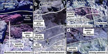
The weathering profiles in the basalts vary in facies from palaeosols that include a bright red siliceous upper horizon (Fig. 3a) to palaeosols that do not include such a distinctive horizon (Fig. 3b). As was pointed out by Feakes, Holland & Zbinden (Reference Feakes, Holland and Zbinden1989), sedimentary reworking by surface runoff occurred at the top of some profiles and formed lenses of red, silty mudrock and muddy sandstone (Fig. 3c). However, the gradational evolution of texture from a platy lower horizon that partially preserved the texture and greenish-grey colour of the host rock to an upper horizon that becomes increasingly massive and red going up the profiles clearly indicates that this bright red upper part is pedogenic in most profiles (e.g. Fig. 3a). In contrast, the non-silcrete-bearing profiles have a blocky to platy pedal structure throughout, and they evolve upward from dark grey to brownish-grey (Fig. 3b).
(a) Well-developed red-silcrete-bearing profile from the McGillivray Brook locality (palaeosol 2); (b) non-silcrete-bearing profile from the Doctor's Brook locality (palaeosol 1); (c) weathering profile truncated and downcut by a surface runoff deposit at the Doctor's Brook locality (palaeosol 2); (d) gradational truncation of a calcite–epidote vein network by weathering at the Arisaig locality (palaeosol 2).

4. Field methods
The herein studied intra-basaltic palaeosols are from the three general localities of Doctor's Brook, Arisaig and McGillivray Brook (Fig. 1), which are estimated to expose increasingly young strata. Nine weathering profiles were studied. From the oldest to the youngest, they are:
(1) Doctor's Brook palaeosol 1 (Fig. 3b): thick palaeosol that does not include a siliceous, bright red upper horizon. Other soils of this type occur within the succession, but the lack of a siliceous upper horizon made them more susceptible to substantial bulldozing by the subsequent lava flow.
(2) Doctor's Brook palaeosol 2 (Fig. 3c): palaeosol truncated by a surface runoff deposit.
(3) Arisaig palaeosols 1 to 5 and McGillivray Brook palaeosols 1 and 2: palaeosols with a massive, bright red upper horizon (Fig. 3a). Arisaig palaeosols 4 and 5 and McGillivray Brook palaeosols 1 and 2 are possibly the lateral continuation of each other.
The five best-preserved and fully accessible weathering profiles (the Doctor's Brook and McGillivray Brook profiles as well as Arisaig palaeosol 2) were studied in the field and sampled at irregular intervals, making sure to sample on both sides of observable transitions in texture or lithology. Because of tidal erosion and deposition, the weaker B horizons of Arisaig palaeosols 1, 3, 4 and 5 are inaccessible below the low tide line and/or under thick gravel. They were therefore only partially sampled, each including one sample of the basalt host rock and one sample of the bright red upper horizon to better constrain the diagnostic properties of this highly matured weathering material.
5. Analytical methods
5.a. X-ray diffraction and fluorescence
X-ray diffraction (XRD) analysis for all samples was performed at the Département des Sciences de la Terre et de l'Atmosphère de l'Université du Québec à Montréal, Canada (Table 1). Bulk chemical compositions (Table 2) were determined with X-ray fluorescence (XRF) for both major and trace elements in all samples using a Philips PW2400 X-ray spectrometer at the Regional Geochemical Centre at Saint Mary's University (Halifax, Nova Scotia, Canada). Major elements were determined using the fusion method on glass discs, whereas trace elements were analysed separately using pressed pellets from the same powdered samples.
X-ray diffraction (XRD) analyses. Semi-quantitative vol.% based on diffraction peak intensities in relation to a quartz standard

X-ray fluorescence analyses. Detection limit is 0.1% for major elements and 1 ppm for minor elements

LOI – loss on ignition.
Our data suggest that Zr was relatively immobile during weathering based on nearly constant ratios of this element in relation to other relatively insoluble high-field-strength elements (HFSEs), such as Nb (Table 2). In contrast, Al and Ti, which are usually assumed to be immobile during weathering (e.g. Nesbitt & Young, Reference Nesbitt and Young1982, Reference Nesbitt and Young1989; Nesbitt, Reference Nesbitt and Lentz2003) vary tremendously in their ratios with Zr, Nb and each other (Table 2), suggesting substantial mobility in these cases. Of the co-varying elements, Zr shows the greatest concentrations (Table 2). Moreover, laboratory experiments show that Zr is the least mobile and therefore the most appropriate element to use for assessing mobility in secondary environments (Hodson, Reference Hodson2002). Therefore, mass gains and losses in Si, Al, Ti, Fe, K, Ca and Na contents from host rock to palaeosol were measured in relation to Zr (Fig. 4) by calculating the element-mass-transfer coefficient of Anderson, Dietrich & Brimhall (Reference Anderson, Dietrich and Brimhall2002; modified from Brimhall et al. Reference Brimhall, Chadwick, Lewis, Compston, Williams, Danti, Dietrich, Power, Hendricks and Bratt1992). Note that mass gains and losses for Mg, Mn and P are not plotted to avoid congestion, but their concentrations can be observed in Table 2.
Vertical mass gains and losses in the Middle to Upper Ordovician Dunn Point Formation palaeosols and alluvium with respect to their basaltic host rocks; based on the dimensionless element-mass-transfer coefficients of Anderson, Dietrich & Brimhall (Reference Anderson, Dietrich and Brimhall2002; modified from Brimhall et al. Reference Brimhall, Chadwick, Lewis, Compston, Williams, Danti, Dietrich, Power, Hendricks and Bratt1992) in relation to Zr.

5.b. Element mapping
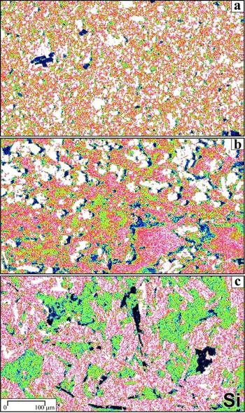
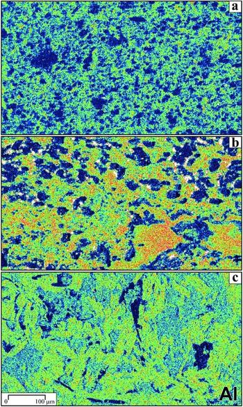
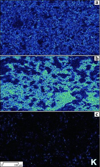
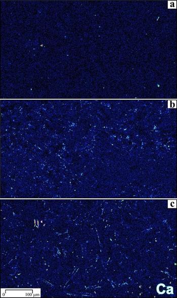
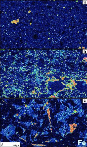
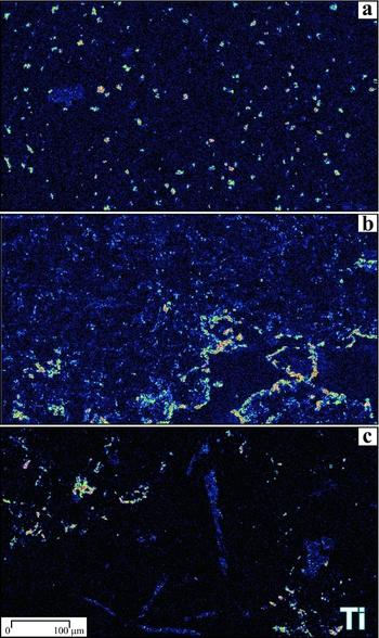
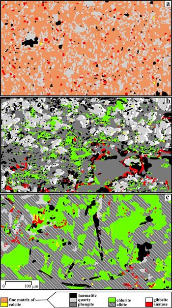
Using an Oxford Instruments LEO 1450 VL scanning electron microscope (SEM) housed by the Regional Geochemical Centre at Saint Mary's University, element mapping was done with energy dispersive spectroscopy (EDS; Goldstein, Reference Goldstein2003) at a ×200 magnification (Figs 5–10) on three carbon-coated polished thin-sections, and mineral mapping was then performed on the latter based on the element maps combined with XRD and thin-section analyses (Fig. 11). The sections were cut from samples A2a (host rock), A2c (B horizon) and A2e (A horizon) of Arisaig palaeosol 2, which is the best developed palaeosol of the succession.
SEM maps showing the distribution of silicon in Arisaig palaeosol 2: (a) sample A2e (Amq horizon); (b) sample A2c (Bo horizon); (c) sample A2a (host rock).

SEM maps showing the distribution of aluminium in Arisaig palaeosol 2: (a) sample A2e (Amq horizon); (b) sample A2c (Bo horizon); (c) sample A2a (host rock).

SEM maps showing the distribution of potassium in Arisaig palaeosol 2: (a) sample A2e (Amq horizon); (b) sample A2c (Bo horizon); (c) sample A2a (host rock).

SEM maps showing the distribution of calcium in Arisaig palaeosol 2: (a) sample A2e (Amq horizon); (b) sample A2c (Bo horizon); (c) sample A2a (host rock).

SEM maps showing the distribution of iron in Arisaig palaeosol 2: (a) sample A2e (Amq horizon); (b) sample A2c (Bo horizon); (c) sample A2a (host rock).

SEM maps showing the distribution of titanium in Arisaig palaeosol 2: (a) sample A2e (Amq horizon); (b) sample A2c (Bo horizon); (c) sample A2a (host rock).

Mineralogical maps of Arisaig palaeosol 2: (a) sample A2e (Amq horizon); (b) sample A2c (Bo horizon); (c) sample A2a (host rock); based on EDS element maps, XRD data (Table 1) and optical microscopy.

The colour scheme in all element maps is set in such a way that the pink to white transition corresponds to a pixel intensity of 30 normalized to 100 (Figs 5–10). In this colour scheme, quartz appears as white on the Si maps and as dark blue in the Al maps, and vice versa for gibbsite; chlorite appears as green on the Si maps and as light blue on the Fe maps; albite appears as pink (red to white) on the Si maps and as green on the Al maps; haematite appears as orange on the Fe maps and as light blue on the Ti maps; anatase appears as orange on the Ti maps; calcite appears as light blue to orange on the Ca maps; and phengite (Si–K–Fe–Mg-rich and Al-poor mica) appears as light blue on the K maps, green to orange on the Al maps and green to pink on the Si maps.
Carriers of Zr could not be found in any of the three carbon-coated polished sections by mapping alone, although these sections were cut from samples that contain 158 to 177 ppm of that element (samples A2a, A2c and A2e in Table 2). In other (regular) thin-sections, zircons are occasionally observed, ranging in size from 20 to 275 μm, suggesting that Zr is entirely concentrated in scarce, disseminated zircon crystals of medium silt to medium sand size.
6. Results
The intra-basaltic weathering profiles are here described based on field observations paired with thin-section, SEM, XRF and XRD analyses. The suffix symbols used for the soil horizons are based on the USDA Keys to Soil Taxonomy (Soil Survey Staff, 2010).
6.a. Early alteration features in the basaltic host rocks
The earliest stage of alteration occurred during emplacement and cooling of the basalt flows, resulting in penetrative albitization and chloritization as well as varying degrees of silicification, haematization and calcitization (Jutras, Quillan & LeForte, Reference Jutras, Quillan and LeForte2009). This alteration is closely related to a tight network of calcite–epidote veins that are truncated by the palaeosol profiles and therefore preceded weathering (Fig. 3d).
XRD data and optical microscopy indicate that the mafic host rocks are dominated by albite (20 to 72%), quartz (4 to 36%), chlorite (13 to 27%), haematite (4 to 15%) and calcite (1 to 20%), along with minor anatase (~ 1%) (Table 1). Textural and micro-structural relationships on thin-sections make it clear that the albite and chlorite are alteration products of, respectively, calcic plagioclase and a mafic glass (Fig. 11c). In some sections, chlorite and quartz are closely intermingling in the form of irregular pockets and small veins, whereas haematite is dissociated from them as disseminated patches, suggesting that some chlorite may have altered to quartz and haematite in late and more oxidizing stages of basalt cooling. Quartz is also found in cherty xenoliths, which are abundant in some basalts.
Much of the haematite is present as phenocrysts of pseudomorphically replaced clinopyroxene around which feldspar laths are interlocking (Fig. 11c). These haematized phenocrysts are characterized by high Ti contents (Figs 9–11). Some of the clinopyroxene grains are also replaced by calcite, either entirely or at the rim of haematized phenocrysts (as in Fig. 11c).
6.b. Red-silcrete-bearing palaeosols
The most common pedogenic facies in the intra-basaltic palaeosols of the Dunn Point Formation is characterized by a platy, reddish-grey Bo horizon, and a distinctive bright red Amq horizon. In some of these red-silcrete-bearing palaeosols, the Bo horizon is underlain by an illuvial Co horizon (e.g. Doctor's Brook palaeosol 2 and McGillivray Brook palaeosol 1; Fig. 4), whereas others are characterized by a direct transition between the altered but unweathered basaltic host rock and the Bo horizon (e.g. Arisaig palaeosol 2 and McGillivray Brook palaeosol 2; Fig. 4). The following descriptions relate to Arisaig palaeosols 1–5, McGillivray palaeosols 1–2 and the base (Co and Bo horizons) of profile 2 at Doctor's Brook.
6.b.1. Mildly weathered basalt (Co horizon) at the base of the profiles
At the base of some of the profiles is a zone of mildly weathered basalt that maintained the volcanic textures of the host rock (Fig. 3a, c), but which differs slightly from it in terms of mineralogy and chemical contents. In terms of mineralogy, this mildly weathered basalt maintained most of its feldspar content and is mainly characterized by much higher haematite content (Co horizon). This is also reflected by strong Fe enrichments (Fig. 4). Na and Ca tend to be depleted, but less strongly than in the overlying horizons, and Al, Ti, Si and K are either immobile or showing varying degrees of enrichment (Fig. 4).
6.b.2. Platy, reddish-grey Bo horizon
The Co horizon evolves upward into a platy, reddish-grey B horizon (Fig. 3a, c) that is strongly enriched in K, weakly to moderately enriched in Al, Fe and Ti (Bo horizon), moderately depleted in Si and strongly depleted in Na and Ca (Fig. 4). It is mainly composed of quartz (15 to 43%), haematite (8 to 33%), phengite (7 to 28%), chlorite (4 to 48%), calcite (0 to 21%), gibbsite (0 to 6%), anatase (1 to 2%) and very little feldspar (2 to 11%) (Table 1).
Most of the feldspars are altered to phengite, which is a Si–K–Fe–Mg-rich and Al-poor mica that most probably formed during deep burial diagenesis from a montmorillonite precursor (see Section 7). According to the SEM analysis of a large crystal in the B horizon of Arisaig palaeosol 2, it is composed of 56% SiO2, 27% Al2O3, 9% K2O, 4% FeO, 3% MgO and less than 1% Na2O. Some of the feldspars are also broken down to quartz and closely associated gibbsite (Fig. 11b). The remaining feldspars (not observable on all thin-sections) are in rare and disseminated small pockets of preserved host rock material. It is noteworthy that the transition between a zone in which virtually all feldspars are preserved (the host rock or the slightly enriched Co horizon of some profiles) to a zone in which most of them are destroyed is very thin (less than 10 cm) in all profiles of this soil facies.
The original chlorite of the host rock is relatively intact in this horizon, except in Arisaig palaeosol 2, in which more than half of it is altered to phengite, quartz, gibbsite and haematite (Fig. 11b). The Ti-rich haematized phenocrysts are destroyed, and as a result, this material is finely disseminated throughout the horizon (Figs 9–11). In many areas, haematite is mostly excluded from the growth of large authigenic phengite crystals and concentrates around them along with anatase (Fig. 11b, lower right corner).
6.b.3. Massive, bright red Amq horizon
The platy, reddish-grey Bo horizon evolves gradationally into a platy and eventually massive bright red material in Arisaig palaeosols 1 to 5 and McGillivray palaeosols 1 and 2 (Fig. 3a). This upper horizon is mainly composed of quartz (52 to 87%), haematite (5 to 17%) and phengite (5 to 19%), with very little chlorite (0 to 6%) and feldspars (up to 8%, but mainly 0) remaining (Table 1).
Although the mineralogy of this horizon mainly differs from the underlying Bo horizon in terms of a substantial increase in the ratio of silica versus other minerals, it is structurally quite distinct (Fig. 11c). Quartz is mostly found in irregular-shaped accumulations that contrast with the smoother, globular quartz of the Bo horizon and host rock (Fig. 11), which suggests that, while the original quartz of the host rock might have been mechanically disseminated, some new silica was added as a cement, probably by crystallization from soil water.
Anatase seems to have remained unaffected by chemical weathering, but was mechanically disseminated throughout the horizon as fine silt-size crystals (Fig. 10). Haematite is disseminated as fine silts as well, but also more finely disseminated in an amorphous matrix of silica and phyllosilicates, giving the horizon its bright red tinge (Figs 9, 11c). Figure 11a also includes the coarse silt-size fragment of a Ti-rich haematized phenocryst thickly coated with quartz (to be discussed later). Also common in this red horizon, but avoided for XRF and XRD analyses, are elongated millimetric to centimetric discrete areas of As–Fe–Co and V mineralization associated with Mn-rich carbonate, which possibly formed in association with the oxic decay of organic matter.
The horizon is very strongly enriched in K, moderately to strongly enriched in Si, moderately depleted in Al, Fe and Ti (in increasing order), and strongly depleted in Ca and Na (Fig. 4). Strain calculations by Jutras, Quillan & LeForte (Reference Jutras, Quillan and LeForte2009) indicate a near absence of post-burial collapse in this bright red horizon, which suggests that it was well cemented during pedogenesis and that its high silica content is therefore pedogenic, as is also suggested by nearly proportional eluviation in the underlying Bo horizon. This red silcrete is here classified as an Amq horizon (sensu the USDA classification scheme).
6.c. Non-silcrete-bearing palaeosol
Profile 1 from the Doctor's Brook locality (Fig. 3b), although thick and well developed, does not include a distinctive bright red upper horizon and differs in many other ways from the above-described palaeosols.
6.c.1. Poorly developed dark grey Boq horizon at the base of the profile
Doctor's Brook palaeosol 1 includes a moderately weathered, dark grey Boq horizon with preserved volcanic textures at the base of the profile (Fig. 3b). This horizon is composed of 50 to 64% quartz, 11 to 17% chlorite, 11 to 16% haematite, 7% feldspars, 4% phengite, 1 to 4% calcite and ~ 1% anatase (Table 1). It is moderately depleted in Ca and Na, moderately enriched in Ti, Al, Si and Fe, and strongly enriched in K (Fig. 4).
6.c.2. Blocky, dark grey Bo horizon
The poorly developed Boq horizon evolves into a blocky, dark grey horizon (Fig. 3b) in which volcanic textures of the host rock are preserved in granule-size (2–4 mm) blocks surrounded by thin zones of phengite with opaque clouds of haematite. Most of the feldspars in the granule-size blocks are replaced by quartz (Table 1). The mineralogy of this horizon is similar to that in the B horizon of red-silcrete-bearing palaeosols, but it is richer in quartz (48 to 54%). It also includes haematite (23 to 30%), chlorite (9 to 10%), phengite (6 to 9%), feldspars 3 to 4%), anatase (1 to 2%) and calcite (0 to 2%) (Table 1). Relative to the host rock, it shows relatively strong Na and Ca depletion (more so than in the underlying Boq horizon, but less so than in the B horizon of red-silcrete-bearing profiles), relatively stable Si contents, minor Ti, Al and Fe-enrichment, and very strong K-enrichment (Fig. 4).
6.c.3. Platy, brownish-grey A horizon
The thin, blocky, dark grey B horizon evolves upward into a platy, brownish-grey A horizon (Fig. 3b). This horizon includes 25 to 35% quartz, 21 to 34% haematite, 11 to 24% chlorite, 6 to 18% phengite, 6 to 14% feldspars, 1 to 2% anatase and 0 to 4% calcite (Table 1). In terms of element mobility, Ca and Na are strongly depleted (but again, less so than in the red-silcrete-bearing profiles), Si is moderately depleted, Al and Ti are stable or slightly depleted, Fe is moderately depleted near the top and lightly enriched at the base of the horizon, and K is strongly enriched throughout (Fig. 4). The uppermost part of this horizon shows less depletion in Ca and Na, which is interpreted as being the result of contamination following the emplacement of the next mafic lava (Fig. 4).
6.d. Surface runoff material (on top of Doctor's Brook palaeosol 2)
Most basalt flows of the Dunn Point Formation sharply overlie the massive red silcrete developed in the previous flow, and several areas show evidence of a bulldozing of the looser material overlying the silcrete. In some cases, this material may have included supra-soil alluvium.
In Doctor's Brook palaeosol 2, the contact between the reddish-grey Bo horizon and the massive red material is not gradational but sharp. The latter profile also shows evidence of downcutting at the contact between the two contrasting materials. As a result, the red upper material evolves laterally from 15 to 30 cm in thickness in less than 1 m, sharply below a tabular contact with the overlying basalt flow (Fig. 3c).
The red material that sharply overlies the reddish-grey Bo horizon in Doctor's Brook palaeosol 2 is also not as bright in colour as the Amq horizon of other profiles, and it is more grainy in thin-section, especially in its uppermost portion, which is a muddy sandstone (Fig. 12). Silt-size zircons and sand-size lithic clasts are observed in the sandy uppermost portion. The red upper portion of profile 2 at Doctor's Brook is therefore interpreted as a sedimentary deposit. As none of the lithic clasts are exotic to the Bears Brook Volcanics lithologies, only local reworking is inferred.
Surface runoff deposit above Doctor's Brook palaeosol 2 in thin-section, with polarized light; (a) sandy upper part (sample DB2g), with a coarse sand-size lithic clast of weathered basalt in the lower left quadrant and a well-preserved orthoclase clast in the lower right; (b) silty lower part of the deposit (sample DB2h).

Apart from the high zircon contents, the mineralogy of this deposit is similar to that of the bright red upper horizons, with 77 to 79% quartz, 8 to 12% phengite, 7 to 8% haematite, ~ 3% chlorite and 0 to 1% feldspars (Table 1). In terms of chemical contents, it strongly contrasts with the Amq horizons by being strongly depleted in everything except K, which is less strongly enriched than in the underlying reddish-grey horizon (Fig. 4). It is noteworthy that the ratios of Si on Al, Fe and Ti are consistent with those of the Amq horizons, with increasing depletion from Si to Ti (Fig. 4). It is also noteworthy that occasional K-feldspar grains (Fig. 12a) are very well preserved, which is a common observation in early Palaeozoic sandstones (Basu, Reference Basu1981) owing to the tendency for higher groundwater pH at that time of geological history (Weaver, Reference Weaver1989; Jutras, Quillan & LeForte, Reference Jutras, Quillan and LeForte2009).
7. Petrogenetic history
7.a. Hydrothermal alteration during emplacement and cooling
Based on their high sodium contents compared with the overlying soil horizons, it is assumed that the samples here referred to as host rocks (Tables 1, 2) were mostly spared from pedogenic weathering and that the occasional presence of gibbsite (observed only through XRD in three host rock samples) would be related to infiltration from the soil profile above. However, the host rock basalt experienced penetrative hydrothermal alteration in the form of albitization, chloritization, haematization, quartzification and calcitization (Table 1) during emplacement and cooling, prior to the pedogenic overprinting that truncates these features (Fig. 3d; Jutras, Quillan & LeForte, Reference Jutras, Quillan and LeForte2009).
The presence of both chlorite and haematite, with some evidence of chlorite replacement by haematite, suggests that the hydrothermal system evolved from being anoxic to slightly oxic during the cooling process. Calcite accumulation along the rims of haematized phenocrysts suggests that haematization and calcitization of clinopyroxenes occurred subsequent to emplacement (Fig. 11c). The absence of chlorite within these phenocrysts, although they are closely intermingling with chlorite from the matrix (Fig. 11c), suggests that the clinopyroxenes experienced haematite replacement quite late in the hydrothermal history, subsequent to chloritization.
In the sub-aerial setting that is indicated by the oxic pedogenic weathering that took place subsequent to emplacement and cooling, abundant rainfall was necessary to facilitate such thorough hydrothermal alteration and pervasive calcite–epidote veining. As the basalts cooled, albitization and chloritization ceased, along with the calcite–epidote veining, but the silicification and haematization that was onset during the late stages of the cooling lingered for the entire history of weathering and pedogenesis.
7.b. Formation and diagenetic evolution of the red-silcrete-bearing palaeosols
7.b.1. Contextual constraints
The nearly complete removal of soluble cations (such as Na and Ca) and breakdown of feldspars into secondary minerals (0 to 11% of the original host rock content in the A horizons, and 3 to 55% in the B horizons) in the red-silcrete-bearing palaeosols of the Dunn Point Formation suggest that the climate was warm and humid during pedogenesis. In the greenhouse world that characterized the Middle to Late Ordovician transition (Berner, Reference Berner1990), the inferred climate is compatible with the 42°S latitude that is suggested by palaeomagnetic data from the Dunn Point Formation (Van der Voo & Johnson, Reference Van der Voo and Johnson1985). In the modern world, such a climate would favour the proliferation of a thick vegetation cover, which would have a profound impact on soil chemistry and pedogenic processes. In the absence of superior land plants, Middle to Upper Ordovician soils that developed under a warm and humid climate would have experienced conditions that are not reproducible today, and the study of the Dunn Point Formation palaeosols can therefore not rely heavily on modern analogues.
In the absence of a substantial vegetation cover, low temperature mineral–water interactions in most common crustal rocks promote an increase in pH (Krug & Frink, Reference Krug and Frink1983) even in the presence of abundant lichens (Schatz, Reference Schatz1963), which are inferred to account for most of the thin Ordovician continental cover along with non-symbiotic cyanobacteria, algae and fungi, and perhaps small clumps of bryophytes (Kenrick & Crane, Reference Kenrick and Crane1997; Taylor, Taylor & Krings, Reference Taylor, Taylor and Krings2009). In this context, it is likely that a weathering system in mafic (i.e. base-rich) rocks may have been able to eventually develop a high pH, despite warm and humid conditions. Conversely, it is very unlikely that such a system would have reached very low pH values.
Although relatively high groundwater pH may have been common in both Proterozoic and early Palaeozoic times based on the abundance of detrital illite in marine mudrocks of those intervals (Weaver, Reference Weaver1967), the early Palaeozoic period would have been especially susceptible to developing groundwater alkalinity because of its overall lower atmospheric carbon levels and therefore higher rainwater pH than those of Precambrian times (Kasting, Reference Kasting1993). The observation that K-feldspars, which are only resistant to weathering in alkaline conditions (Blum & Stillings, Reference Blum, Stillings, White and Brantley1995), are substantially more abundant in lower Palaeozoic sandstones than either prior to or after (Basu, Reference Basu1981) is an indication of how unusual surface conditions were at the time. The Dunn Point Formation provides the only early Palaeozoic record of palaeosols developed on primary rocks and may therefore present a unique set of soil facies.
It should also be pointed out that the Middle to Upper Ordovician Dunn Point Formation palaeosols formed shortly before the onset of a small, Late Ordovician ice age (Saltzman & Young, Reference Saltzman and Young2005). Hence, based on the theory that solar luminosity has been increasing linearly through time (Sackmann & Boothroyd, Reference Sackmann and Boothroyd2003), they would have evolved under a lower atmospheric carbon budget and therefore a higher rainwater pH than soils of any previous, non-glacial geological period (i.e. periods when weathering processes are more active, and when groundwater alkalinity is therefore more likely to be achieved). Although atmospheric carbon dioxide levels may still have been a few times higher than today in Middle to Late Ordovician times (Berner, Reference Berner1990; Kasting, Reference Kasting1993), the effect this would have had on rainwater pH would have been negligible for pedogenic processes compared with the deep reaching influence of a mature vegetation cover, which can increase carbonic acid concentrations in soils by one or two orders of magnitude (Weaver, Reference Weaver1989; Berner, Reference Berner, White and Brantley1995; White, Reference White, White and Brantley1995).
In summary, we consider that the basic-rock-hosted soils of the Middle to Upper Ordovician Dunn Point Formation were most unlikely to develop substantial acidity. Hence, although the mobility of some elements can see a similar increase at both low and high pH (Al, for instance), any process involving extremely low pH conditions is considered highly improbable in our interpretations and discussions.
7.b.2. Sequential constraints
To understand the pedogenic processes that affected the Dunn Point Formation basalts, some unravelling of shallow and deep burial diagenetic overprints is necessary. The substantial K-enrichment that is observed in all the basalt profiles is unlikely to have been concentrated by pedogenesis because the mafic host rocks only include minute amounts of K. Assuming Zr immobility, large inputs of K must have occurred from outside the system during or after pedogenesis. Because of the lack of veining in the impermeable muddy palaeosols, and based on the observation that K is evenly distributed in the micaceous matrix (Fig. 7b, c), this K input must have occurred prior to deep burial compaction, while pedogenic clays were still permeable and not yet converted to micas. The most likely source for this enrichment is the thick, K-rich rhyolite that was emplaced above the basalts. Interactions between the cooling felsic magma and the rising aquifer, following rhyolite emplacement, would have provided large amounts of K in solution.
If the K-enrichment is eodiagenetic, then the discrete accumulations of quartz and gibbsite in the B horizon of Arisaig palaeosol 2 (Figs 5b, 6b, 11b) preceded shallow burial and therefore occurred during pedogenesis, as the absence of K-enriched rims around them suggests that they did not grow at the expense of a K-bearing phase (Fig. 7b). The breakdown of albite into quartz and gibbsite most likely occurred through pedogenic processes taking place early, while the basaltic host rock still harboured residual heat, making soil water a more aggressive solvent. Once this residual heat subsided, the breakdown of albite must have produced mainly smectites to account for the accommodation of eodiagenetic K as an exchangeable cation, as K-rich smectites are the only suitable low temperature precursors to phengite, which would have subsequently formed during deep burial and orogenic compression. In support of this, low K concentrations in the underlying basaltic host rock (Table 2) suggest that the lack of pedogenic smectites in this material prevented it from accommodating K during eodiagenesis. The high Fe and Mg contents of the phengite suggest that this smectite precursor had a montmorillonitic composition.
7.b.3. Pedogenic mobilization of Al and Si
Although most of the original Si contents of the basaltic host rocks stayed behind in quartz, montmorillonite and residual chlorite, a substantial amount was lost from the B horizon with a corresponding enrichment in the overlying A horizon (Fig. 4). Silica was therefore eluvial in the B horizon and illuvial in the A. This lost silica from the B horizon recrystallized in the A horizon disseminated in a red clay matrix as well as in discrete accumulations that are characterized by very irregular shapes, which suggest that they were subject to intermittent etching (Figs 5a, 11a). Alternating precipitation and dissolution of silica in the A horizon is probably responsible for the thorough mixing of secondary minerals and anatase (only primary mineral to be largely preserved, other than trace minerals) in that horizon (Figs 5–11a).
The occasional presence of haematized phenocrysts that are thickly coated with etched silica (Fig. 11a), which are not present in the B horizon (Fig. 11b), suggests that silica enrichment in the A horizon started occurring quite early in the evolution of the soil, protecting these host rock components before weathering had a chance to destroy them. In contrast, the clinopyroxene habit of these haematized phenocrysts is entirely lost in the silica-depleted B horizon (Fig. 11b). These observations concur with the nearly isovolumetric weathering and negligible post-burial collapse that is indicated by strain calculations (Jutras, Quillan & LeForte, Reference Jutras, Quillan and LeForte2009) in suggesting that silica enrichment must have occurred early, simultaneous to the leaching of other elements, thus forming a compaction-resistant silcrete that prevented substantial collapse from occurring during deep burial.
Although illuvial for Si, the A horizon was clearly eluvial for Al, Fe and Ti, in increasing order of depletion, and the latter elements are almost proportionally enriched in the B horizon (Figs 4–11). This near proportional displacement of Si, Al, Fe and Ti from one horizon to the next is clearly pedogenic. However, the respective behaviour of these elements would be unexpected in modern, warm and humid environments because of the substantial decrease in soil pH that is caused by the lush vegetation that is now systematically associated with such an environment. Under normal acidic conditions, Ti is usually immobile, and although Fe and Al may be subject to mild cheluviation, they are always less mobile than Si in primary rocks (White, Reference White, White and Brantley1995; Nesbitt, Reference Nesbitt and Lentz2003).
In near-surface conditions, the threshold above which dissolved Al becomes easier to maintain in solution than dissolved Si is at pH ~ 8 (Blatt, Middleton & Murray, Reference Blatt, Middleton and Murray1980; Ming & Mumpton, Reference Ming, Mumpton, Dixon and Weed1989; Hay & Sheppard, Reference Hay, Sheppard, Bish and Ming2001). Such high pH values must have been achieved in the upper part of the profile owing to higher weathering and evaporation rates, whereas the lower part of the profile maintained a pH slightly below 8 (Jutras, Quillan & LeForte, Reference Jutras, Quillan and LeForte2009). However, to facilitate the precipitation of silica, the pH must not have evolved for prolonged periods of time beyond a pH of 9, above which Si becomes increasingly soluble (Blatt, Middleton & Murray, Reference Blatt, Middleton and Murray1980).
The mobilization of Si from the lower to the higher parts of the profiles would be best achieved through periodic ground saturation during peak rain seasons, allowing Si to be mobilized in solution throughout the profile (Fig. 13a, b). During periods dominated by evaporation, the water table would have gradually come back down to its phreatic level and, in the process, groundwater in the upper part of the vadose zone would have evolved to a pH above 8 and become saturated in Si, the precipitation of which would have promoted the formation of a silcrete over a period of several decades (Fig. 13c, d). Conversely, some Al was probably dislodged from the upper horizon under the same alkaline conditions to precipitate in the lower horizon, where pH was not as high (Fig. 13c, d), a process that was possibly involving chelates. These pedogenic processes would be best achieved under a monsoonal climate, with a prolonged wet season followed by a prolonged drier season. However, the latter would have remained wet enough to be undersaturated in Ca, which was mostly removed from the profiles (Fig. 4), although the preservation of a fair amount of calcite in the B horizons is additional evidence that the system never evolved toward acidic conditions (Jutras, Quillan & LeForte, Reference Jutras, Quillan and LeForte2009).
Pedogenic model: (a) establishment of a high water table following the emplacement of a mafic flow; (b) ground saturation during peak rain season, resulting in the mobilization of various cations in solution throughout the profile; (c) gradual lowering of the aquifer to its phreatic level during the drier season, and establishment of a vertical gradient of groundwater pH owing to vertical differences in weathering and evaporation rates; (d) establishment of well-developed horizons after several decades; (e) subsequent mafic flow emplacement and bulldozing of the mechanically weak uppermost part of the palaeosol above the zone of induration by silica accumulation.

7.b.4. Pedogenic mobilization of Fe
Because the solubility of Fe is not predicted nor observed to increase in alkaline water, and because the extremely low pH that is required to dissolve haematite (< 3.5; Blatt, Middleton & Murray, Reference Blatt, Middleton and Murray1980; Brookins, Reference Brookins1988; Thornber, Reference Thornber, Butt and Zeegers1992) is unlikely to be achieved without involving a lush vegetation cover, the substantial leaching of Fe from the upper horizon of red-silcrete-bearing palaeosols was probably not controlled by pH. Besides the contextual improbability, calcite and smectites could not have been preserved in a soil that would have evolved under such extreme weathering conditions.
Under oxic conditions, the mobilization of Fe is best achieved through chelation by siderophores, which are small organic molecules that are mainly produced by bacteria, fungi and grasses (Kraemer, Reference Kraemer2004). The strong capacity of lichens for chelation has also long been recognized (see review by Chen, Blume & Beyer, Reference Chen, Blume and Beyer2000). There is presently a lack of studies specifically on their production of siderophores, but some lichens are known to be formed by the symbiosis of a common siderophore-producing photobiont (cyanobacteria) with a variety of mycobionts that are potentially siderophore-producing (Haselwandter & Winkelmann, Reference Haselwandter, Winkelmann, Varma and Chincholkar2007). Of those, the lichen-forming Dothideales order is already known to include siderophore-producing species (Renshaw et al. Reference Renshaw, Robson, Trinci, Wiebe, Livens, Collison and Taylor2002), but the siderophore production of other lichen mycobionts remains to be assessed (Haselwandter & Winkelmann, Reference Haselwandter, Winkelmann, Varma and Chincholkar2007).
Not only are siderophores more effective at mobilizing Fe than other forms of biogenic chelates, they are also effective at a much wider range of pH, and in some cases, more effective at high pH than near neutral (Cline et al. Reference Cline, Powell, Szaniszlo and Reid1982; Lindsay, Reference Lindsay1991). The high concentration of Fe that was mobilized from the A to the B and C horizons of the red-silcrete-bearing palaeosols suggests that, although the primitive Ordovician plant cover would have produced a much lower amount and variety of biogenic chelates than the more evolved covers of subsequent geological times, this must have been compensated for by the high efficiency of those chelates, which probably included abundant siderophores. This is supported by the greater representation of cyanobacteria and fungi (by themselves or symbiotically combined in lichen) on pre-Silurian continental surfaces, which did not harbour many other forms of life (Kenrick & Crane, Reference Kenrick and Crane1997; Taylor, Taylor & Krings, Reference Taylor, Taylor and Krings2009). It was also pointed out by Kraemer (Reference Kraemer2004) that very small concentrations of free siderophores can have a tremendous effect on the capacity of a soil solution to mobilize Fe, and that competition with other chelates possibly works at inhibiting them. In other words, not having to share the land with as many non-siderophore-producing plants as today may in part explain the inferred efficiency of the thin and primitive Ordovician cover at mobilizing Fe in soils. Moreover, this high efficiency may also imply that siderophore-producing cyanobacteria were the dominant photobiont of Ordovician lichens, at least in the study area.
7.b.5. Pedogenic mobilization of Ti
Because it takes an even lower pH (< 2.5; Brookins, Reference Brookins1988; Thornber, Reference Thornber, Butt and Zeegers1992; Van Baalen, Reference Van Baalen1993) to mobilize Ti than Fe, and because this element is not known to be strongly affected by chelation, Ti is not observed to be substantially mobilized in modern soils, (Nesbitt, Reference Nesbitt and Lentz2003). However, Ti was systematically more mobile than Fe and Al during pedogenesis of the red-silcrete-bearing Ordovician palaeosols of the Dunn Point Formation (Fig. 4). Figure 10 makes it clear that it is mostly the Ti that was disseminated in low concentrations within haematite that was being removed from the A horizon to accumulate in the clay matrix (now phengite) of the B horizon, while anatase crystals of 1 to 10 microns, which are also found in the host rock, were left behind.
Although the commonly assumed immobility of Ti in pedogenic processes has been challenged by a few studies in extreme weathering environments (e.g. Cornu et al. Reference Cornu, Lucas, Lebon, Ambrosi, Luizao, Rouiller, Bonnay and Neal1999), this seems to be the first case in which it is systematically observed to be more mobile than Al, Fe and Si in a soil profile. The explanation for such an unusual behaviour of Ti therefore needs to involve an atypical setting. The only unusual variable that we can identify is the inferred development of a high soil pH despite humid weathering conditions, which, as noted earlier, would have been difficult to achieve outside of early Palaeozoic times.
Although the Eh–pH modelling of Brookins (Reference Brookins1988) does not suggest an increase of Ti solubility at high pH, experimental data on Ti solubility at high pH are lacking, and the only report of Ti concentrations in natural groundwaters at very high pH (11 to 12) suggests substantial Ti solubility in those conditions (Kranov, 1973 as reported in Van Baalen, Reference Van Baalen1993). Moreover, according to Schmets, van Muylder & Pourbaix (Reference Schmets, van Muylder, Pourbaix and Pourbaix1966), Ti would tend to speciate into a negatively charged complex (HTiO3 −) above pH 5.6, which would greatly enhance its solubility in alkaline solutions. Hence, the few available studies on low temperature Ti solubility do not preclude that the substantial leaching of Ti from the A horizon of red-silcrete-bearing palaeosols may be simply explained by the inferred high pH of their soil water at the time of pedogenesis, but neither do they strongly support this hypothesis. However, in natural systems, pH is never the only geochemical variable, and the combination of other factors have also contributed to enhance Ti solubility. For example, fluoride complexing in alkaline water was proposed to explain the observed mobility of Ti during the zeolitic alteration of tephra in a salt-lake environment (McHenry, Reference McHenry2009), a process that is well documented in high temperature experiments along with chlorine complexing (Rapp et al. Reference Rapp, Klemme, Butler and Harley2010). Carbonate complexing in alkaline water is another process that is inferred to be responsible for the mobilization of HFSEs in mesodiagenetic (Hayes, Walling & Tieh, Reference Hayes, Walling and Tieh1996) and metamorphic (Hynes, Reference Hynes1980; Murphy & Hynes, Reference Murphy and Hynes1986) environments, and this process of HFSE mobilization was also demonstrated in laboratory experiments at room temperature (Wood, Reference Wood1990). In the humid continental context that is inferred for the weathering of the Dunn Point Formation basalts, which were veined by calcite prior to soil formation, carbonate complexing is more likely to have occurred than fluorine or chlorine complexing.
In our view, an even greater possibility than carbonate complexing to explain Ti mobility in the red-silcrete-bearing palaeosols is that higher soil water pH in Ordovician times may have allowed a very particular array of bacterial, fungal or lichen species to thrive, especially on poorly drained soils that often experienced saturation, resulting in frequent, prolonged interactions between surface flora and groundwater. Some of these extinct species may have produced chelates that were especially successful at mobilizing Ti, just as modern siderophores are especially efficient at mobilizing Fe. This inferred cheluviation would better explain than carbonate complexing the almost proportional enrichment of Ti in the B and C horizons, as the organic decay of chelates prevents them from substantially mobilizing insoluble cations beyond the centimetric scale (Schaetzl & Anderson, Reference Schaetzl and Anderson2005). Hence, cheluviation is suggested for both Fe and Ti in the Dunn Point Formation, although the two elements may not have been displaced by the same varieties of chelates, and although none of the chelates involved are necessarily still being produced by modern vegetation. However, a direct influence of alkalinity or complexation by carbonate, fluorine and/or chlorine in alkaline water cannot be ruled out as contributing or dominant factors.
Finally, the stronger mobility of Ti than Fe and Al is one more piece of evidence against the view that the observed leaching of elements from the A horizon may be related to acidic conditions, as both Fe and Al are predicted to be more soluble than Ti at low pH (Blatt, Middleton & Murray, Reference Blatt, Middleton and Murray1980; Brookins, Reference Brookins1988; Thornber, Reference Thornber, Butt and Zeegers1992; Van Baalen, Reference Van Baalen1993). Moreover, the extreme weathering conditions (pH < 2.5) that would be required to mobilize Ti are unlikely to occur in a thickly vegetated world, and even less so in the nearly barren Middle to Late Ordovician landscape.
7.b.6. Evidence for a high water table during pedogenesis
Thickness of the red-silcrete-bearing palaeosols does not seem to be related to variations in the length or intensity of weathering, as the thickest profiles are not necessarily the best developed. The relatively sharp transition from host rock or Co horizon with well-preserved feldspars to B horizon material in which the feldspars are mostly destroyed probably corresponds to the normal minimum level of the water table (Fig. 13), the depth of which controlled profile thickness. The overall limited thickness of weathering, although penetrative, suggests that the water table was quite high during the development of all red-silcrete-bearing palaeosols in the Dunn Point Formation, a conclusion that is consistent with the periodic saturation that is inferred to be instrumental to the formation of the silcretes.
7.c. Formation and diagenetic evolution of the non-silcrete-bearing palaeosol
Although the lack of a red Amq horizon in Doctor's Brook palaeosol 1 could be related to a premature termination of pedogenesis due to an early emplacement of the subsequent flow, some features of this non-silcrete-bearing facies preclude that it may be a poorly developed equivalent of the red-silcrete-bearing facies. It is, for one thing, the thickest of the succession, with the base of the B horizon reaching a depth of 120 cm, compared with a maximum of 100 cm in the red-silcrete-bearing profiles. It also shows substantial Si depletion in the A horizon, whereas the preservation of haematized phenocrysts in quartz nodules within the A horizon of the other soil type suggests that Si-enrichment in the latter was onset during early pedogenesis.
It is here proposed that the differences in facies may be climate related. As was previously discussed, many features of the red-silcrete-bearing profiles imply occasional saturation from a temporary rise of the water table during a pronounced rain season followed by a prolonged drier season. This monsoonal-type climate may have been constrained to warm orbital cycles, whereas cold cycles would have prevented the development of monsoons.
The lack of a pronounced rain season would have made the weathering environment less aggressive, as substantiated by a less thorough removal of soluble cations and a better preservation of calcite than in the other type of soil. It would also have caused the water table to be overall lower, which would have promoted the formation of a thicker soil profile, and less prone to rise, which would have prevented the peculiar upward migration of silica that is inferred in the other soil type. Moreover, a drier climate would have also accounted for a better illuviation of chelated Al, Fe and Ti in the B horizon of Doctor's Brook palaeosol 1 than in the red-silcrete-bearing profiles, in which a greater proportion of these elements left the profile entirely (Fig. 4). However, although this palaeosol shows evidence for a drier climate, the substantial breakdown of feldspars (8 to 44% of the original host rock contents) is indicative of a climate that would have been sufficiently wet to support a well-vegetated and therefore acidic setting in the modern world, which would have prevented the preservation of calcite.
7.d. Sedimentary reworking
The coarsening-upward red mudrock to muddy sandstone that downcuts into Doctor's Brook palaeosol 2 (Fig. 3c) is an example of a preserved supra-soil alluvium, which is characterized by a substantial Zr-enrichment through sedimentary reworking (Fig. 4). Contrary to Ti, Fe, Al and Si, which are all included in phengite and were therefore most likely included in its inferred montmorillonite clay precursor, Zr is not included in the micaceous fraction (nor its clay precursor) and is exclusively found in highly resistant silt- to sand-size zircons. The fraction of Ti, Fe, Al and Si that was concentrated in the clay fraction was therefore more likely to be transported out of the system during sedimentary reworking and sorting than zircons, hence their depletion with regards to Zr. In support of this conclusion, lower K/Zr ratios in the reworked material are compatible with our conclusion that Zr was concentrated by sedimentary sorting, leaving a higher ratio of zircon/phyllosilicates, as K-enrichment in a specific host material was limited by the amount of smectite present to incorporate it. Also in support of this conclusion, Zr-enrichment is greatest in the uppermost part of this reworked unit, which is also characterized by coarser and better rounded grains.
Hence, the reworked material not only differs texturally and structurally from the in situ red Amq horizons, it also differs from them substantially in terms of mineralogical and therefore elemental ratios. As depletion of every major element in relationship with Zr is what should be expected from the effect of sedimentary reworking, the Si/Zr enrichments in the red Amq horizons of the well-developed profiles, matched with relatively proportional depletion in the underlying horizon, are additional clues that this material is not the product of substantial sedimentary reworking.
7.e. Palaeoenvironmental implications of the eodiagenetic K-enrichment
As previously argued, substantial K-enrichment in both types of palaeosols, as well as in the surface runoff deposits that reworked them, most probably occurred during shallow burial, shortly after rhyolitic emplacement. This inferred eodiagenetic enrichment implies that, not only did K become abundant in the groundwater solution, the latter would also have easily saturated itself in K within an aquifer that had gradually developed a high pH through the weathering of each basalt flow in the succession that underlies the thick rhyolite, thus favouring the incorporation of K as an exchangeable cation in the montmorillonite of the poorly consolidated basalt palaeosols. In contrast, the normally acidic conditions that characterize modern phreatic waters, because of their abundant organic matter contents, would have prevented this eodiagenetic K-enrichment, which may explain why the latter is only commonly observed in pre-Silurian palaeosols (Gay & Grandstaff, Reference Gay and Grandstaff1980; Kimberley & Grandstaff, Reference Kimberley and Grandstaff1986; Zbinden et al. Reference Zbinden, Holland, Feakes and Dobos1988; Feakes, Holland & Zbinden, Reference Feakes, Holland and Zbinden1989; Nesbitt & Young, Reference Nesbitt and Young1989; Palmer, Philips & McCarthy, Reference Palmer, Philips and McCarthy1989; Krois, Stingl & Purtscheller, Reference Krois, Stingl and Purtscheller1990; Rainbird, Nesbitt & Donaldson, Reference Rainbird, Nesbitt and Donaldson1990; Macfarlane & Holland, Reference Macfarlane and Holland1991; Fedo, Nesbitt & Young, Reference Fedo, Nesbitt and Young1995; Maynard et al. Reference Maynard, Sutton, Robb, Ferraz and Meyer1995; Rye & Holland, Reference Rye and Holland2000; McLennan, Simonetti & Goldstein, Reference McLennan, Simonetti and Goldstein2000; Panahi, Young & Rainbird, Reference Panahi, Young and Rainbird2000; Beukes et al. Reference Beukes, Dorland, Gutzmer, Nedachi and Ohmoto2002; Yang, Holland & Rye, Reference Yang, Holland and Rye2002; Utsunomiya et al. Reference Utsunomiya, Murakami, Nakada and Kasama2003). Finally, this eodiagenetic K-enrichment is additional evidence supporting our conclusion that soil formation in the intra-basaltic palaeosols of the Dunn Point Formation is highly unlikely to have ever developed strongly acidic conditions.
8. Conclusions
Based on field and analytical data from the upper part of sub-aerial mafic flows in the Middle to Upper Ordovician Dunn Point Formation, the following conclusions were derived regarding surface processes that occurred during and following emplacement:
(1) The flows were emplaced under a sufficiently humid climate to promote pervasive chloritization and albitization from interactions with abundant rainfall during cooling of the lavas.
(2) A nearly complete breakdown of feldspars by subsurface weathering during the limited amount of time that separates each lava flow suggests that the climate was not only humid, but also relatively warm (i.e. aggressive in terms of weathering).
(3) In the red-silcrete-bearing profiles, the rapid transition from basalt with well-preserved feldspars to a relatively thin soil profile in which the feldspars are mostly destroyed suggests that the normal minimum level of the water table was quite high during pedogenesis.
(4) Peculiar patterns of eluviation and illuviation suggest that most of the intra-basaltic palaeosols experienced episodic saturation followed by long periods dominated by evaporation, during which soil water pH in the upper part of the profiles would have become high enough for Al to become more mobile than Si. Soil waters were able to become alkaline despite warm and humid conditions through the breakdown of feldspars, which promote alkalinity, and owing to the lack of a strong counteraction by acids from either rainfall or land plants; as Middle to Late Ordovician times were characterized by relatively low atmospheric carbon (Kasting, Reference Kasting1993) and, mainly, by a poorly vegetated surface (Kenrick & Crane, Reference Kenrick and Crane1997; Taylor, Taylor & Krings, Reference Taylor, Taylor and Krings2009). A gradient in the degree of alkalinity would have also developed within the soil profiles owing to differential weathering and evaporation rates, with the lower part of the profiles maintaining a pH that was closer to neutral and in which Al was therefore less mobile than Si.
(5) The Dunn Point Formation palaeosols show evidence of very effective cheluviation processes, which were managing to not only displace Fe and Al significantly, but also and especially Ti, even though they were only involving organic ligands derived from a very thin and primitive vegetative cover. This substantial mobilization of normally insoluble cations may have been favoured by carbonate, fluorine and/or chlorine complexing in an alkaline solution, but nearly proportional illuviation in the B and C horizons seems to point to cheluviation as the main process, and the unusual mobility of Ti is therefore more likely related to the presence of especially efficient chelates. The bacterial, fungal and lichen populations that thrived under the inferred alkalinity-prone continental environments of early Palaeozoic times (Weaver, Reference Weaver1989; Jutras, Quillan & LeForte, Reference Jutras, Quillan and LeForte2009) may have differed substantially from those of prior or subsequent geological times, which are inferred to have been more acidic. This particular biota would have produced unknown varieties of organic compounds, some of which might have been specifically good at mobilizing Ti.
(6) The presence or absence of a red silcrete facies in the upper part of the profiles is best explained by long-term climatic variability such as that provided by orbital cycles, with warm cycles promoting the development of a more pronounced rain season, which would in turn promote the occasional ground saturation that is postulated to have been necessary for the formation of these silcretes.
(7) Soil material reworked by surface runoff differs from the in situ Amq soil horizons of the red-silcrete-bearing palaeosols in terms of structure (sharp basal contact versus gradational), texture (grainy versus muddy), colour (greyish-red versus bright red) and chemical contents, as sedimentary reworking concentrated Zr substantially through the preferential removal of elements that were included in the clay fractions, whereas Zr was constrained to silt- and sand-size zircons.
(8) Substantial K-enrichment occurred in the montmorillonite of intra-basaltic soil material and inter-basaltic sediment following the emplacement of a thick, K-rich rhyolite at the top of the basaltic succession, and owing to the lower solubility of K in a high pH aquifer.
Acknowledgements
We wish to thank M. Préda for providing X-ray diffraction analyses, and X. Yang for providing X-ray fluorescence analyses and support with the SEM. We also thank B. Murphy and P. Leat for a constructive review of our manuscript. This project was funded by a FGSR University Grant in Aid of Research, #200292-5760-83540-9999.