

. . . a historian's first duty is to check the validity of his sources and
criticize them. This should be most clear for historians of early
Southeast Asia, where the sources, and interpretation of them made
by the first generations of modern historians, abound in inconsistencies,
contradictions, and the most blatant dilettantish ad hoc speculation.
Michael VickeryFootnote 1
The interpretation of history is a complex and often difficult process. We can only see the past “through a glass, darkly”, or rather, we see fragments of the past, more or less randomly preserved, and we often see those fragments indistinctly. Inevitably, we all have preconceived ideas, formulated more or less clearly in our minds, some of them well-formed, others hazy; some conscious, some subliminal. When reading historical sources, or examining objects from the past, we do not share the same preconceptions as those who wrote the sources, or who made and used the objects. It is all too easy to take an anachronistic view of history, to misinterpret it in the light of our modern experience and knowledge, to make false assumptions which distort the historical record. In this paper, I intend to take issue with what I consider to be one such false assumption: that is, that because today, and for the past several centuries, the Strait of Melaka is and has been the main waterway of transit between the Indian Ocean and the South China Sea, that it must always have been so.Footnote 2
From the beginning, I wish to make clear that I approach this question from the point of view of someone with a background in Chinese studies. I am not a specialist in Southeast Asian history, still less in the history of India or other potentially relevant regions. Nor can I make any claim to being immune to the problems caused by preconceptions, just referred to above. I can only claim that I make some effort to be aware of those problems, and always to question my personal understanding of historical sources. In particular, if there seems to be some difficulty interpreting sources, I assume that it is probably my understanding of them that is defective, rather than assuming that they must be in error and reinterpreting them to fit with my way of thinking.
Being able to read Chinese sources, but having no knowledge of Southeast Asian or Indian languages (or of Arabic or Persian), is not, I think, a serious handicap for the period with which I intend to deal here. The simple fact is that most of the early history of Southeast Asia is written in Chinese. Indeed, the name of what appears to have been the most important polity in Southeast Asia during the first half of the period currently under considerationFootnote 3 is known only in Chinese, as Funan.Footnote 4 Without the Chinese sources, very little would be known of Funan: archaeology has recently helped to fill some of the gaps in knowledge, but many remain. It has at times been something of a fashion to criticise the Chinese sources, for various perceived biases and shortcomings,Footnote 5 but I would suggest that they are a very great deal better than nothing, and that all sources are inevitably biased to some extent. This applies equally to archaeology, for some human activities tend to leave much more evidence than others, and some kinds of artifacts are much more likely to survive than others. Pottery is a good example of one that is commonly preserved, while items made of perishable materials frequently leave little or no trace. As far as the Chinese written sources are concerned, in my personal view, it is often not so much the sources themselves which are at fault but the way in which they are interpreted. A very simple example of the way in which they are misunderstood is Wolters’ translation of the Chinese character guo Footnote 6 as “kingdom”.Footnote 7 Karlgren gives the meaning of this character as “state, country” or “capital city”.Footnote 8 Its basic meaning was, in fact, a ‘walled town’, which often, to a greater or lesser extent, dominated the surrounding country; but there is no certain implication of rule by a king, as there is in the word ‘kingdom’. Indeed, Chinese writers sometimes used the character guo to refer to countries which are clearly stated not to be ruled by any king. Thus, the Old History of the Tang Dynasty says of the Shiwei Footnote 9 that “their country [guo] has no ruling lord; there are seventeen great chiefs”.Footnote 10 The form of government implied by the word ‘kingdom’, therefore, is not implied by the Chinese term guo. It seems that Wolters later realised that the term had wider implications, but he continued to include ‘kingdom’ among its range of meanings.Footnote 11 However, just as the words ‘state’ or ‘country’ may sometimes refer to a kingdom, although neither of them implies the rule of a king, so the Chinese term guo includes no implication at all of monarchy.
Funan went into decline after about 500 ce,Footnote 12 and was replaced in importance by Srivijaya, usually believed to have been centred on Palembang during this period.Footnote 13 It was the identification of Srivijaya with Palembang which first made me question the importance of the Strait of Melaka. At a later period, when the Strait was undoubtedly an essential waterway, it was ports on or very close to the Strait (such as Melaka and Singapore) which rose to prominence. Palembang, however, is well removed from the southeastern end of the Strait. Ships sailing through the Strait of Melaka had no obvious need to call in at Palembang.Footnote 14 To my, perhaps naive, way of thinking, it would make more sense if, when Srivijaya became the foremost polity of Southeast Asia, the normal route from the South China Sea to the Indian Ocean had been the Sunda Strait. Earlier, when Funan was seemingly the most important country of Southeast Asia, it would appear likely (to me, at least) that neither the Strait of Melaka nor the Sunda Strait was the primary route.Footnote 15
If, then, neither of these two straits was regularly navigated by ships involved in trade with China, how did foreign goods reach Chinese ports? What advantage did Funan gain from its geographical position on the trade routes? Fortunately, Chinese sources provide answers to these questions:
More than three thousand li from its [Funan's] southern border is the country of Dunxun,Footnote 16 on a promontory rising above the sea. Its land is a thousand li Footnote 17 in circumference. The town is ten li from the sea. There are five kings, who are all subordinate to Funan. The eastern boundary of Dunxun is in communication with Jiaozhou.Footnote 18 The western boundary adjoins India, Parthia,Footnote 19 and all the distant countries, [people from] which come and go to trade. The reason for this is that Dunxun turns back and extends into the sea for more than a thousand li. There is no limit to the shore of the Zhang hai [the South China Sea],Footnote 20 and ships have never been able to find a passage through. At its markets, East and West meet and exchange; every day there are more than ten thousand people. Of precious items and high-value goods, there is nothing lacking. There is also the wine-tree, which is similar to the pomegranate. The juice from its flowers is collected and put into a flagon. After several days it becomes wine.Footnote 21
Beyond Dunxun, on a large island in the sea, there is the country of Piqian,Footnote 22 eight thousand li from Funan. It is said that the body of the king is 12 feet high, and his head three feet high. From long ago he has not died, and no one knows his age. The king has supernatural powers. The good and evil deeds of the people of the country, and the future – he knows everything. So no one dares to deceive him. In the south, he is called “the Long-necked King”. The customs of the country are to live in houses, to wear clothes, and to eat short-grain non-glutinous rice. Their language is slightly different from that of Funan. There are mountains where gold is produced: it appears on the surface of stones, without any limit. If someone is condemned according to the law of the country, then his flesh is eaten in front of the king. Visitors are not received into the country; anyone who goes there is also killed and eaten, so travelling merchants do not dare to approach. The king always lives in a tall building. He does not eat meat and does not worship demons or spirits. His offspring live and die like normal people, only the king does not die. The king of Funan has several times sent envoys and letters and received replies. Eating utensils of pure gold for fifty people have often been sent to the king of Funan. They were shaped like round dishes and like small earthenware basins: they were called duoluo,Footnote 23 and contained five sheng.Footnote 24 Some were like bowls, and held one sheng. The king is able to write Indian texts. The writings may have 3,000 words, and tell of his previous incarnations. They are like Buddhist sutras, and likewise discuss meritorious deeds.Footnote 25
Wolters, apparently following Wheatley,Footnote 26 took this passage from the History of the Liang Dynasty to have been derived from information obtained by Kang Tai, who visited Funan in about 245 ce.Footnote 27 Wolters therefore regarded this passage as being relevant to the first half of the third century, rather than to the period of the Liang dynasty (502–556).Footnote 28 This, however, is very unlikely. It is true, as Wolters points out, that Kang Tai is referred to, and even quoted, in the section of the History of the Liang Dynasty dealing with Funan. However, on every occasion, it is made clear that Kang Tai is being cited to provide historical background, and the period when he visited Funan is stated. In the case of the above passage, however, this is not done. Wolters gives three reasons why the information in this passage “cannot refer to any time other than the first half of the third century”. The first is that the History of the Liang Dynasty has “separate passages on two kingdoms on the Malay Peninsula”, PanpanFootnote 29 and Langyaxiu.Footnote 30 Why, then, asks Wolters, is there no separate passage for Dunxun? The answer seems to me to be quite clear. Dunxun was subordinate to Funan, and information about it was therefore included in the passage about Funan. Moreover, Dunxun was not a single kingdom (the text translated above clearly states that there were five kings) but was the name of a region. Dunxun, with a variant Dianxun,Footnote 31 may be a phonetic transcription of the same word which underlies ‘Tenasserim’, still the name of part of Myanmar today (in the form Tanintharyi).Footnote 32 Secondly, according to Wolters, the mention of Parthia (Anxi)Footnote 33 would be anachronistic for the sixth century, as this “was no longer the name for Persia during the period of the Liang dynasty”: the History of the Liang Dynasty, he points out, has “a section on Persia under the heading of Po-ssŭ [Bosi]”.Footnote 34 Wolters is confused here, however. The Chinese never believed that the Parthian Empire had ceased to exist in the third century, and continued to refer to Anxi long after that time. The History of the Sui Dynasty explains this: “the country of AnFootnote 35 (Bukhara) is the Anxi of the HanFootnote 36 dynasty”.Footnote 37 In the History of the [northern] Zhou Dynasty (557–581), there are passages about both Anxi and Bosi: Anxi is said to adjoin Bosi.Footnote 38 Finally, Wolters says that what the History of the Liang Dynasty says about ships crossing the South China Sea is wrong for the sixth century. This is an error, however, due to his incorrect translation of the original Chinese text. There is, then, no reason at all to think that this passage does not relate to the first half of the sixth century.
The last point, regarding incorrect translation, requires further elucidation. The problem lies in the sentence: “There is no limit to the shore of the Zhang hai, and ships have never been able to find a passage through”. Wolters’ translation here reads: “The Zhang Hai [the South China Sea] is of great extent and ocean-going junks have not yet crossed it direct”.Footnote 39 This translation, as already indicated, is that of Wheatley, who followed Pelliot: “La Mer Immense est sans limites et on n'a pas encore pu la traverser directement”.Footnote 40 Pelliot, however, admitted that he found this passage difficult to understand: “La phrase chinoise n'est pas claire”.Footnote 41 It does present difficulties, but I am sure that my reading of it is correct. It must be understood as answering the question, posed hypothetically at the beginning of the preceding sentence, of why Dunxun was so important. The reason cannot have been that ships had never crossed the South China Sea direct. Whether they sailed direct or not would not prevent them reaching the Strait of Melaka, and thus avoiding the land-crossing of the Peninsula. In any case, there is evidence that they were sailing across the Sea direct from Java to Guangzhou before this time, as will be seen below. The real reason for the importance of Dunxun was that, for a very long distance to the south, there was no passage beyond the Malay Peninsula, which formed a barrier to shipping. There was, therefore, no route which avoided unloading ships at Dunxun and carrying goods overland across the Peninsula, unless a very long detour was made. The passage about Piqian is relevant because it indicates one reason which tended to discourage the search for new routes: it was often dangerous to venture into unknown territory, where sailors and merchants might find themselves victims of hostile cannibals, or suffer some other unpleasant fate. Even if such stories were not always true, the fact that they were told and believed was sufficient to deter exploration.Footnote 42
Before moving on from Dunxun, it may be useful to suggest, at least approximately, where it was located. Jacq-Hergoualc'h has doubted whether there ever was a portage across the Malay Peninsula, or at least believes that “the Malay Peninsula was seldom traversed”.Footnote 43 His arguments are extremely weak, however. He claims that it would have been difficult to cross the Peninsula because possible river routes had “often volatile waters” and were surrounded by “dense, tropical vegetation”.Footnote 44 Against such claims, it must be assumed that a regularly-used route would have been cleared and made passable. It is notable in this context that overland routes all the way from China to India are described in some detail in a text dating from about 800 ce.Footnote 45 If it was possible to traverse mainland Southeast Asia for such a long distance, it would surely have been very much easier to make the short crossing of the Malay Peninsula. In fact, “dense, tropical vegetation” is to some extent imaginary. The vegetation beneath the canopy of dense tropical forest is usually quite sparse, as the trees block light to the forest floor.
Jacq-Hergoualc'h also points out that there is a lack of archaeological remains at the supposed termini of the trans-peninsular routes, or, indeed, along their length. This may be meaningless, however, for he leaves the most northerly possible routes largely out of consideration from this point of view, “because today their end-points on the west coast are in Burmese territory, and therefore difficult, if not impossible, to study at the moment”.Footnote 46 This is unfortunate, as it seems very likely that, if Dunxun was in the Tenasserim region, it is precisely these northern routes that are most likely to be the ones in question. He also stresses the difficulty of transporting such items as glassware and pottery across the Peninsula without it getting broken.Footnote 47 This is a largely illusory problem. Neither glassware nor pottery was a principal item of trade. Wang Gungwu has noted that: “The export of pottery and porcelain ware had still to await the rapid growth of the industries . . . during the T'ang dynasty”.Footnote 48 When the Portuguese made the long voyage down the west coast of Africa and into the Indian Ocean, they were not seeking direct access to the porcelain of China. It was spices that they were seekingFootnote 49 – pepper, cinnamon, cloves, and so on – and it was also items of this kind that interested the Chinese.Footnote 50 In the opposite direction, Chinese silk and metals (mainly copper, bronze, iron, and silver) were carried to Southeast Asia, India and beyond.Footnote 51 Not only were all these items more or less unbreakable, they were also, for the most part, unlikely to leave much trace for archaeologists to discover (even metal was very likely to be re-used, rather than simply discarded).Footnote 52 In arguing in this manner, Jacq-Hergoualc'h makes evident a serious problem with archaeology: it is heavily biased towards what survives. In the hot, humid climate of most of Southeast Asia, almost anything of organic origin usually decays and leaves little trace, while broken sherds of pottery, and fragments of glass, are far more likely to remain. Broken pottery was virtually useless, and was normally simply discarded, which accounts for the importance of pottery at many archaeological sites. In any case, it seems likely to me that, if pottery could survive in comparatively small ships tossed about on the waves of the seas, it could have been packed in such a way that it would have survived well enough when transported on the backs of elephants, or perhaps of human porters.
The best clue to the location of Dunxun is the statement in the Chinese text that it was “on a promontory rising above the sea”.Footnote 53 This must have been a landmark for sailors, visible for some distance, which is why it was specifically mentioned. I would tentatively suggest that it may have been the headland in the vicinity of the Khao Sam Roi Yot National Park, about 60 km (36 miles) south of Hua Hin in Thailand. Limestone hills just behind this promontory rise to some 600 m (2,000 feet) above sea level, so that the range must be visible for a considerable distance out to sea. There do not seem to be many similar high headlands along this stretch of coast. Directly west of the headland is the Tenasserim River, which would have given easy access to the western coast of the Peninsula.
There was, however, another route from the Indian Ocean to the South China Sea, which did not require any land crossing. It was very much longer, and may well have been more dangerous, due not only to the vagaries of weather, but also to the possibility of piratical attacks. It would have been considerably lengthened by the need to wait for favourable winds, as it required sailing in almost opposite directions at different stages. No doubt it would originally have been pioneered by the desire to reach different markets from those to which the route via Dunxun gave access. This was the route to Java and, via the Sunda Strait, to the lands around the South China Sea.
I do not intend to discuss at any length what Ptolemy's Geography has to say about Southeast Asia and China, partly because I have no relevant expertise, but mainly because Ptolemy's knowledge of the region was clearly limited. Such as he had must have reached him mainly at third or fourth hand, at best. There is also some question whether the Geography as it now survives resembles Ptolemy's original work very closely.Footnote 54 As the earliest surviving manuscript of the text dates from more than a millennium after Ptolemy wrote it, it must at least be likely that numerous scribal errors have entered the text during the process of copying and recopying. Toponyms, often entirely unfamiliar to the scribes, were particularly liable to be miscopied.Footnote 55 Moreover, Ptolemy applied quite arbitrary adjustments to his data. For example, “the reported distance by sea from India to Kattigara (an ‘outpost of the Sinae’ . . .) is . . . reduced . . . to bring the E/W dimension again close to 180º”.Footnote 56 Clearly, this kind of adjustment is likely to have caused considerable distortion of the true positions of places in the far eastern portion of Ptolemy's known world.
The sea route to Kattigara, according to Marinus of Tyre, was twenty days coasting south from the Golden Chersonese to a place called Zabai, whence, sailing ‘a little to the left of south’ one came in ‘some days’ to Kattigara. How many days he could not tell, but thought ‘some’, as reported to him by mariners, meant ‘many’. Ptolemy . . . criticized him severely, and said ‘some’ meant ‘few’, and that Kattigara was therefore close by the Golden Chersonese. He plotted it on his map, fixed the latitude and longitude, and then asserted that the coast beyond trended westward . . . . But, calculations notwithstanding, he was guessing . . ..Footnote 57
It therefore seems that little faith can be reposed in Ptolemy's localisations of places in Southeast Asia. The description of Kattigara as “an outpost of the Sinae” suggests that it may well have been Jiaozhou,Footnote 58 as it was sometimes taken to be, before consensus shifted towards Oc Eo.Footnote 59 It is clear, however, that Ptolemy himself knew very little about Kattigara, least of all its precise location, so trying to identify it exactly is probably a waste of time. Even its relative location may be erroneous. It appears that Ptolemy may sometimes have heard of the same place under different names, from different sources, and treated the names as those of distinct localities. It has been suggested, for example, that he did this with Sumatra.Footnote 60 Java may appear as many as three times in the Geography.Footnote 61 There is no good reason that I can see to locate Ptolemy's Iabadiou (Yavadvīpa) in Borneo, as van der Meulen does. His translations of Iabadiou as “Barley Island” and of the Sungai Jelai of Borneo as “Barley River” are almost certainly wrong,Footnote 62 for barley was not a crop of tropical regions. Anyone who wishes to make a claim of this kind needs to produce evidence that barley was known in Southeast Asia at an early period.
In spite of these caveats, Ptolemy cannot be completely ignored. Van der Meulen's studies of the Geography, though not entirely convincing, are of great interest. He reaches the conclusion that Ptolemy shows no sign of being aware of the existence of the Strait of Melaka. Insofar as van der Meulen was able to reconstruct a sailing route from the Bay of Bengal to the South China Sea, it apparently passed along the west coast of Sumatra to Java and the Sunda Strait. He explains this by suggesting that the Strait of Melaka was a dangerous route. He also suggests that the west coast of Sumatra was itself of considerable interest to merchants, because it was a source of gold, found in quantity in the Minangkabau region.Footnote 63
Some of the possible dangers of passing through the Strait of Melaka have already been hinted at in the description of Piqian above. At least some of the inhabitants of Sumatra were probably cannibals, who did not receive visiting merchants amicably.Footnote 64 Van der Meulen considered that “the main reason why the ancient mariners chose the way around Sumatra must have been the fear of pirates”. He also pointed out that the Strait of Melaka was “full of uncharted and treacherous mud banks, [and] notorious for its transverse and unreliable winds, sudden squalls alternating with doldrums. Any immobilized ship became the defenseless prey of hordes of small indigenous craft, as can be inferred from later descriptions”.Footnote 65 A mid-nineteenth century sailing directory notes that: “The Monsoons are very irregular in the Straits of Malacca, and the winds variable . . .”.Footnote 66
João de Barros refers to “shallows” in the area of Capacía in the Strait, and indicates that the Portuguese used local Muslim (“Moorish”) pilots.Footnote 67 Afonso de Albuquerque also feared possible attack while his ships were in the “region of shallows”, and therefore regrouped the fleet, but “they did not encounter any of the great dangers which the Moors tell fables about finding in these low regions of Capacía, similar to those told about the channel of Frandes or the dangers of Scylla and Charybdis . . .”.Footnote 68 Nevertheless, Barros relates that: “Along the entire length of the strait, . . . there are shallows, salt marshes and small islands separated by channels in which ships can become lost . . . . [F]rom sheer avidity men would normally have sought out all the passageways, but here it was dangerous . . .”.Footnote 69
Taking a sailing ship into a long and fairly narrow strait was always risky. If no passage through the strait could be found, it was often impossible to turn round and go back. Sailing ships cannot sail against the wind. Depending on the rig of a ship, it was possible to sail roughly to within about four points of the compass, or 45 degrees, from the direction of the wind (to either side). Square-rigged ships could only sail to within about six points from the wind.Footnote 70 This left a considerable angle, of at least 90º, and possibly as much as about 140º, within which the wind made it impossible for a ship to sail. With these restrictions, manoeuvring a sailing ship in a channel filled with shoals was by no means simple. It is easy to imagine that sailors preferred more open waters, with plenty of room for manoeuvre, even if within sight of a coastline.
I am aware that many readers of this paper will, by now, be thinking of Faxian'sFootnote 71 famous journeys, which have often been interpreted as including a return voyage through the Strait of Melaka.Footnote 72 It should be noted, however, that at least some early commentators did not share this opinion. This includes both James Legge and Herbert Giles, who both translated Faxian's account of his travels.Footnote 73 It is worth giving careful consideration to this issue, as Faxian is one of the earliest travellers to give an account of his route from the Indian Ocean to China. What follows is my own translation of his narrative of the voyage from Sri Lanka to China:
Having obtained these works in the Fan language,Footnote 74 he boarded a large merchant ship, which could carry more than 200 people. A small ship was tied behind it. Sailing the seas is dangerous, so this preparation was made in case the big ship was wrecked. Getting a favourable wind, they sailed eastwards for two days. Then a gale blew up, and the ship sprang a leak and water came into it. The merchants wanted to get into the small ship, but the men on it were afraid that there would be too many people, so they cut the rope. The merchants were terrified that their lives might end in a moment, fearing the water leaking into the ship, so they took their goods and merchandise and threw them into the water. Faxian also took his pitcher and washbasin and other superfluous items and threw them into the sea, but he was afraid that the merchants would take the sutras and images. Devoutly, he called upon Guanshiyin Footnote 75 [Avalokiteśvara] and all the Buddhist saints of China: “I have travelled far to seek the Law. If you are willing, awesome holy ones, turn back the flow [of the leaking water?], and let us reach a place to stop”. The gale blew like this for thirteen days and nights, and they reached the shore of an island. After the tide had receded, the place where the ship was leaking could be seen, and it was stopped up. After this, they went forward again. On the sea, there are many pirates. If they come upon you, you are lost. The sea was boundless. East and West could not be distinguished. Only by observing the sun, moon and the constellations of stars was it possible to voyage. When it was overcast or rainy, nothing could be done but to sail with the wind. During the night, all that could be seen were great waves clashing, glowing like fire, and turtles and various monsters of the deep. The merchants were confused and did not know where they were going. The sea was deep and bottomless. There was nowhere to drop the anchor-stone and stop. When the sky cleared, it was possible to know East and West, and the course could be corrected. If there had been any hidden rocks, they could not have survived.
Thus they sailed for some nine or ten days,Footnote 76 then they came to a country called Yepoti. In this country foreign religions and Brahmans flourish, but the Way of Buddha is scarcely known. He [Faxian] stayed in this country for five months, then continued in another merchant ship, which also could carry more than 200 people. Taking supplies for fifty days, they set sail on the sixteenth day of the fourth month. On this ship Faxian lived comfortably. They sailed north-east, towards Guangzhou. After more than a month, during the second hour of the night, they encountered a black windFootnote 77 and torrential rain. The merchants and passengers were all terrified. At this time also, Faxian devoutly invoked Guanshiyin and all the saints of China. With the divine aid of these holy ones, they passed through to daylight. When it was light, all the Brahmans talked together and said: “It is because we are carrying this Buddhist monkFootnote 78 that we have misfortune and have incurred this suffering. Let us put this beggarFootnote 79 ashore on an island. We cannot allow one man to endanger all of us”. Faxian's patronFootnote 80 said: “If you put off this ‘beggar’, then you must put me off, too. If not, then you must kill me. For if you put off this monk, then when I reach China, I shall speak about you to the ruler of the country. The ruler of China reverently believes in the Way of Buddha, and honours mendicant monks”. All the merchants then hesitated, and did not dare to put him off.
After this the sky was continuously overcast. The helmsman constantly steered wrongly. Thus passed more than seventy days. Food and drink were almost exhausted. Salt seawater was used for cooking. Dividing the good water, each person could get two sheng Footnote 81 . When this was almost all gone, the merchants discussed and said: “Normally, Guangzhou can be reached in fifty days, but now we have exceeded this by many days. Can there not be something wrong?” So they sailed north-west to look for the shore, day and night for twelve days. They came to the southern shore of Lao ShanFootnote 82 in the prefecture of Changguang,Footnote 83 and then were able to get good water and vegetables. After passing through so many dangers and living in fear and anxiety for so many days, suddenly they reached this shore. When they saw the kinds of vegetables,Footnote 84 they knew they were in China. Nevertheless, they could not see any people or signs of life, so they did not know what to do. Some said they had not yet reached Guangzhou, others said they had passed it. No one could come to any decision. So they got into a small boat and went ashore to look for someone, so that they could ask their whereabouts. They encountered two hunters who were just returning, and got Faxian to interpret and ask them. Faxian first reassured them, and asked: “What people are you?” They replied, saying: “We are disciples of Buddha”. Again he asked them: “What have you been looking for in these mountains?” Then they lied and said: “Tomorrow is the fifteenth day of the seventh month, and we wanted to gather peaches to make an offering to Buddha”. Again he asked: “What country is this?” They replied: “This is within the boundaries of Changguang prefecture in Qingzhou,Footnote 85 under the rule of Jin”.Footnote 86 When they heard this, the merchants were delighted. Then they asked for their goods [from the ship], and sent men to Changguang. The prefect, Li Yi,Footnote 87 was a devout Buddhist. When he heard that there was a monk who had come across the seas on a ship, bringing sutras and images, then he sent men to the shore, to welcome the sutras and images, and bring them back to the prefectural town.Footnote 88
Several points in my translation require clarification. It has usually been understood that Faxian sailed for 90 days, before arriving at Yepoti. It has, however, been considered that this is far too long.Footnote 89 Apart from any other considerations, it would surely have been very likely that the ship would have run out of fresh water, not to say food, long before the end of three months. It is also possible that the original Chinese means “some nine or ten days”, as I have translated. The use by Faxian of the word xu here indicates that he was only giving an approximate number. I doubt whether he counted days precisely, at any time during the voyage. His numbers therefore cannot be expected to be entirely accurate. It may also be that they have been corrupted during the course of transmission of this work, which was written long before printing came into use in China. Numbers are very prone to be miscopied by scribes, and there is little possibility of checking and correcting them. Fifty days for the journey from Yepoti to Guangzhou also seems too long,Footnote 90 and it would surely have been an unwise crew which laid in supplies for exactly the same number of days as the normal length of the voyage, without any provision for emergency.
As the numbers of days given by Faxian are of dubious accuracy, calculations made on their basis regarding the direction of prevailing winds cannot be reliable.Footnote 91 It is not at all clear exactly when Faxian's ship left Sri Lanka. Faxian does not tell us, so the time of departure can only be calculated from the numbers of days and months which he gives for the length of voyage and of his stay in Yepoti. These being uncertainly accurate, the timing of this stage of the voyage cannot be reliably ascertained. If I am right about “some nine or ten days”, rather than “some 90 days”, then the ship must have sailed from Sri Lanka well after early September (as Grimes calculated).Footnote 92 From Grimes’ charts, showing prevailing winds, it would seem likely that the wind would have been favourable in October,Footnote 93 and I would therefore suggest that it was then, probably late in the month, that the ship actually set sail. In the Bay of Bengal, in “September and October the prevalent winds are W. and S.S.W.; . . . after the middle of September the Monsoon begins to die away, and winds, variable between N.E. and N.N.W., are not uncommon”.Footnote 94
Nor is it by any means clear that Yepoti was the intended destination of this ship. It was clearly blown far off course, and was completely lost, and out of sight of land, for some time. Grimes believed that it must have been blown by the storm “in a general north-east direction”.Footnote 95 I would suggest that what actually happened is that it encountered a northerly wind, which, as just mentioned above, is not uncommon in late September and October, and that the ship was then blown towards the south or south-west. The island where the leak was repaired must have been somewhere off Sumatra. There is absolutely nothing to indicate that the ship ever passed through the Strait of Melaka, or, indeed, through any noticeable strait. It was out of sight of land for days, in water that was too deep for the anchor to hit bottom. That does not sound like the Strait. In fact, it seems very likely to me that its original course towards the east was probably intended to take it to the Malay Peninsula. The merchants on board, and Faxian, would have landed on the west coast of the Peninsula and crossed it by land, quite possibly at Dunxun.
Eventually, having been blown off course into the Indian Ocean, west of Sumatra, the ship turned back onto its original eastward course, and reached the coast of Yepoti. It is reasonable to believe that the sailors would have been aware that there was always likely to be land somewhere to the east. Yepoti is the Chinese transcription of Yavadvīpa.Footnote 96 I can see no reason at all to think that it meant anything other than Java.Footnote 97 Since there is nothing in Faxian's account of his voyage to suggest that the ship passed through the Strait of Melaka, the suggestion that Yepoti was in BorneoFootnote 98 can safely be dismissed. In fact, Borneo figures only rarely in early Chinese records relating to Southeast Asia. It was normal for ships to keep well away from Borneo, at least from its western coast, because of a large and still notorious area of small islands, shoals and reefs, which fills a large part of the South China Sea between Borneo and the mainland of Southeast Asia. Part of this area is still uncharted, and is known as the ‘Dangerous Ground’.Footnote 99 In order to avoid these hazards, the normal shipping routes kept close to the coast of what is now Vietnam.Footnote 100 As late as the mid-nineteenth century, when navigation aids were considerably better than they had been a millennium earlier, it was still considered that keeping close to the coast of “Cochin China” was often preferable, as “the water near the coast is generally smoother, and shelter and anchorage may be had if necessary”.Footnote 101
Whether or not Faxian sailed through the Sunda Strait is not clear from his account. It is possible that the ship on which he sailed from Sri Lanka reached port somewhere on the south coast of Java, and that, during the several months of his stay, he crossed the island by land, departing from the north coast. It is certain that he left Java on a different ship, and apparently with mainly different companions, for there was no threat to put him ashore during the difficulties of the first leg of the voyage, as there was in the second. It would seem, too, that he may have been the only person aboard who could speak Chinese, as he was called upon to interpret when the ship eventually reached Shandong. Unfortunately, the origins of the two ships are not made clear, but it seems likely that the second one, at least, was Southeast Asian, principally carrying Javanese Hindus to trade in China.
It may well be that the passage through the Sunda Strait only began to be used at all frequently at the time of Faxian's voyages (413–414). It is almost precisely at this period that Java begins to appear in the Chinese dynastic histories.Footnote 102 There is also another early Buddhist record of Java, but under a different name from that used by Faxian. In a Chinese account of the life of the Kashmiri monk Guṇavarman,Footnote 103 it is recorded that he went to the island of Shepo,Footnote 104 where he met with considerable success in converting the ruler of the island and its people. Apparently, like Faxian, he sailed from Sri Lanka to Java, but no details whatsoever of his voyage are recorded. Subsequently, in 424, Buddhist monks in China requested the emperor of the Liu SongFootnote 105 dynasty to invite him to China, and a ship was sent from Guangzhou to fetch him. However, he had already embarked on the ship of a merchant who, from his name, must have been Indian. His original intention was not to go to China, but to “a small country” along the route. It seems, however, that the ship sailed to Guangzhou without stopping.Footnote 106 Unfortunately, no detail of sailing routes is given. Nevertheless, it is evident that, during the 420s, there was regular contact between China and Java, for Chinese Buddhist monks had clearly heard about Guṇavarman and his activities on the island, otherwise they could not have made their request to the Song emperor. It would seem also that merchants from South Asia were visiting Java en route to China.
The contact between China and Java in relation to Guṇavarman appears to be a good example of the “cultural, diplomatic, and commercial exchanges” which resulted from the shared religion of Buddhism.Footnote 107 It may well be that the embassies from Java which arrived at the Song court in 430 and 433Footnote 108 were at least partly a result of the contacts established a few years earlier because of Guṇavarman. The embassy of 433 arrived in the sixth month (almost exactly equivalent to July; it began on 3 July and ended on 1 August).Footnote 109 An embassy from Linyi had arrived during the previous month. The winds would have been favourable for these embassies to sail to China in early summer. Since Linyi was nearer than Java, its embassy arrived first.Footnote 110 Further embassies arrived in 436, 449 and 452.Footnote 111 By the middle of the fifth century, then, connections between Java and China were well established. It is reasonable to suppose, therefore, that the Sunda Strait was in regular use at this period, and may have already begun to challenge the shorter route which involved a land journey across the Malay Peninsula. It may be noted, however, that, even if they were able to sail all the way from the Indian Ocean to China via the Sunda Strait, ships may well still have been unloaded in Java. Faxian changed ships there, and had to spend several months waiting for the winds to change. This wait was inevitable, so it may be that ships from the Indian Ocean normally did not sail all the way to Chinese ports. This is, in fact, stated by Zhao Rukuo. Although he wrote at a much later period (about 1225), the situation probably did not change very significantly over time. Certainly the seasonality of the monsoon winds must have remained constant, and it was this which forced ships to wait. This is what Zhao says:
ArabiaFootnote 112 is extremely far to the north-west of Quanzhou. It is difficult for the foreign ships to arrive there directly. Setting out from Quanzhou, ships sail for more than forty days to Lambri,Footnote 113 where it is most convenient for them to spend the winter. The next year, they set out again. With a favourable wind, they reach the country only after more than sixty days. The products of this country are mostly carried to Srivijaya and traded there. Merchants then resell them onwards to China.Footnote 114
It should be noted that the expression which I have translated “resell” is zhuan fan.Footnote 115 Zhuan literally means “to rotate” or “to turn [like a wheel]”, and figuratively means “indirect[ly]”. Fan means “to buy in and resell”. This is a clear statement that many goods from the Indian Ocean, especially from its western side, were not carried directly to China, but were sold in Southeast Asia and then traded onwards. Almost certainly it was Southeast Asians who were principally involved in this onward trade. It may also be noted that Zhao implies that “foreign ships” sailed to Arabia, not from it: there is no suggestion that ships from Arabia ever sailed to China. This is supported by Zhou Qufei, who wrote some fifty years earlier than Zhao. Of foreign merchants sailing to China, he says: “Coming from Arabia,Footnote 116 they sail southwards in small ships. When they reach Kollam (Quilon; in Kerala),Footnote 117 they change to large ships and sail eastwards. When they get to Srivijaya, they also come to China like the Srivijayans [that is, by the same sea-route]”.Footnote 118 Zhou also states that Srivijaya “produces nothing”, but that the Srivijayans force passing merchant ships to enter their port. “If foreign ships pass their frontier, and there are any that do not put in to their country,Footnote 119 they will certainly send out an armed force and kill them all [everyone on the ships]. For this reason, their country is rich . . .”.Footnote 120 Clearly, this supports the idea that Srivijayans acquired goods from foreigners (by fair means or foul) and then sold them on to China. Indeed, there is a clear record, dating from about 1115, that frankincense (ru xiang 乳香), an Arabian product, was carried to China in Srivijayan ships.Footnote 121
The practice of indirect trade between Arabia and China is also attested, at an earlier date, by the records from the Cairo Geniza: “not a single Geniza letter referring to direct contacts with China has been discovered thus far”.Footnote 122 However, there is a record of Iṣḥāq Ibn al-yahūdī, who fled from ‘Umān to avoid repayment of a debt. Thirty years later, in 300 ah (912/3 ce), he returned a wealthy man. He was said to have been to China, and it seems that the goods which he brought back were mainly Chinese. Nevertheless, when he tried to repeat the voyage to China three years later, disaster befell him. In Sarīra/Serboza (which must be Srivijaya), the ruler demanded a substantial payment to allow him safe passage. He refused to pay and was murdered, his ship and all his merchandise being seized. This story is told by Buzurg b. Shahriyār in his Wonders of India. Whether it is true or not is unclear. The Cairo Geniza documents “do not attest the travel of Jewish traders to the Far East beyond Sumatra”.Footnote 123 This agrees perfectly with the statement of Zhao Rukuo. It also makes it absolutely clear that the claim of Hirth and Rockhill that Zhao Rukuo wrote a book about “the Chinese and Arab trade” is a gross misrepresentation.Footnote 124 As the original title of Zhao's work clearly indicates, it is about all the various foreigners and foreign countries of which the Chinese had knowledge, principally through the trade at Quanzhou.Footnote 125 The supposed evidence of the Belitung shipwreck, which has been claimed to be an Arabian ship, will be assessed in an appendix to this paper.
Before moving on to further evidence that the Sunda Strait, rather than the Strait of Melaka, was the principal shipping route between the Indian Ocean and China during the period in question here, it may be worthwhile to deal briefly with a possible obstacle to part of my thesis. I have suggested above that the Sunda Strait may have begun to be used on a significant scale during the fifth century, but it has been suggested that the Strait did not exist before 535. In that year, it has been claimed, a huge explosive eruption of the volcano Krakatau (Krakatoa) caused a land-bridge linking Sumatra with Java to sink, thus opening the Strait.Footnote 126 It seems very unlikely that such an event in fact occurred, however. Certainly the Chinese records cited to support it do not amount to very much: their significance has been greatly exaggerated.Footnote 127 A scientific investigation of this alleged explosion of Krakatau in 535 has shown that it almost certainly did not occur.Footnote 128
A crucial piece of evidence in this study is the maritime itinerary of Jia DanFootnote 129 preserved in the New History of the Tang Dynasty. It dates from about 800 ce. Pelliot made a thorough study of it as long ago as 1904, but he had difficulty with the essential section of it: “Cette partie du texte est d'une obscurité déconcertante”.Footnote 130 No one at all seems to have understood it correctly, as will shortly be seen:
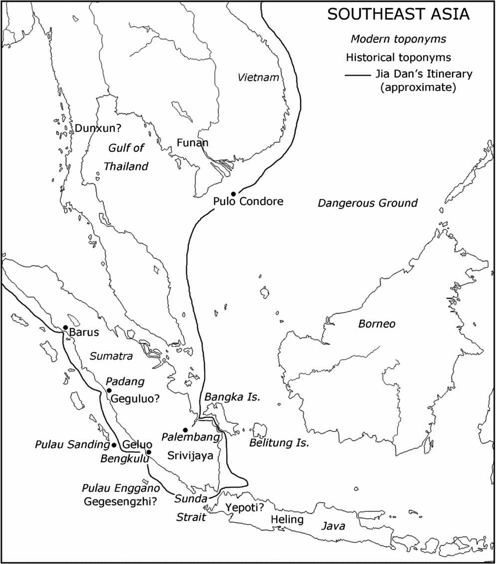
Travelling south-east from Guangzhou by sea, in 200 li one comes to Mount Tunmen.Footnote 131 Then sailing with the wind to the west, in two days one arrives at the Nine Island Rocks. Again, going south for two days, one comes to Elephant Rock. Then voyaging south-west for three days, one reaches Mount Cham Pulao. The mountain is in the midst of the sea, 200 li east of the capital of Huanwang.Footnote 132 Again travelling south for two days, one arrives at Mount Ling.Footnote 133 Voyaging another day, one comes to the country of Mendu.Footnote 134 Again travelling for one day, one arrives at the country of Guda.Footnote 135 After half a day more, one comes to the island of Bentuolang (Panduranga).Footnote 136 Again voyaging for two days, one reaches Mount Juntunong.Footnote 137 Travelling five more days, one comes to a strait, which the foreigners call zhi.Footnote 138 It is a hundred li from north to south. On the north bank there is the country of Luoyue,Footnote 139 and on the south bank there is the country of Srivijaya. Sailing east from Srivijaya for four or five days,Footnote 140 one reaches the country of Heling, which is the greatest of the islands in the south.Footnote 141 Again to the west, one goes out of a strait, and in three days arrives at the country of Gegesengzhi,Footnote 142 which is on another island at the north-west boundary of Srivijaya. The people of the country are mostly brigands. Voyagers are afraid of them. On the coast to the north there is the country of Geluo.Footnote 143 To the west of Geluo there is the country of Geguluo.Footnote 144 Again travelling for four or five days from Gegesengzhi, one reaches ShengdengFootnote 145 Island. Again voyaging west for five days, one comes to the country of Barus. Again travelling for six days, one arrives at JialanFootnote 146 Island of the country of Po.Footnote 147 Again voyaging north for four days, one comes to the country of Sri Lanka. Its northern coast is a hundred li distant from the mainland of southern India.Footnote 148
This remarkable itinerary does not end here, but continues all the way to the east coast of Africa. However, the further it goes, the less accurate it becomes, and the harder it is to follow. For present purposes, it has been followed far enough.
Everyone who has ever commented on this itinerary has assumed that it passes through the Strait of Melaka (at least as far as I am aware).Footnote 149 It clearly does not. The fact that Barus is on the west coast of Sumatra should be sufficient indication of that fact. The other major issue is that, in order to force the itinerary into the Strait, it is necessary to regard the voyage from Srivijaya to Heling as a digression, although nothing in the original text suggests that it is. In fact, the reason why Pelliot had difficulty making sense of the itinerary after the supposed digression to Heling was precisely that he had taken a wrong turning, as it were. Once the false assumption that the itinerary passes through the Strait of Melaka is discarded, this section of the itinerary begins to become clear.
I do not propose to comment in detail on the first part of the itinerary, which has been extensively elucidated by Pelliot.Footnote 150 It is of interest to note, however, that Jia Dan's itinerary arrives at Heling in about 24 days from Guangzhou, which is very much less than the 50 days which Faxian gave for the journey from Yepoti to Guangzhou (see above). It is, however, consistent with Yijing's record that he reached Srivijaya in less than 20 days from Guangzhou.Footnote 151 Pelliot identified Mount Juntunong as Pulo CondoreFootnote 152 (now the Côn Đảo islands of Vietnam). This seems certain and makes a good starting point for a discussion of the controversial section of the itinerary.
From Pulo Condore, in five days, one arrived at a strait, which is described as being “a hundred li from north to south”. No one has ever been able to explain the foreign name zhi satisfactorily: it may simply have been a Chinese transcription of a word meaning ‘strait’ in some Southeast Asian language. Pelliot took it to be the Strait of Melaka: “il n'y a pas à douter que ce détroit soit le détroit de Malacca”.Footnote 153 All the evidence suggests that it is not, however. At least it is odd that the Strait of Melaka should be mentioned before Srivijaya (centred at Palembang). Any ship sailing from China into the Strait and visiting Srivijaya would certainly have gone to Palembang first. The description of the strait as “a hundred li from north to south” also seems unlikely to refer to the Strait of Melaka. This has been taken to refer to its width,Footnote 154 but the natural interpretation is that it is its length. My suggestion is that this is the Bangka Strait, which does indeed run from north to south, although with a double bend in the middle. The essential point is that it leads directly to the estuary of the Sungai Musi, and so to Palembang. The mysterious “country of Luoyue”, of which almost nothing is known, apart from what Jia Dan tells us, has often been placed somewhere near the southern tip of the Malay Peninsula.Footnote 155 This is entirely possible, and it would then indeed be north of the Bangka Strait. The very limited information available, however, does not really support this. In the only early reference to Luoyue apart from those of Jia Dan, it is said that Geguluo is situated to the south-west of it.Footnote 156 As will be seen shortly, Geguluo was on (or perhaps near) the west coast of Sumatra. It seems strange to locate a place on the Malay Peninsula in terms of somewhere in western Sumatra. The available information is so limited that no clear solution can be offered, but my own tentative suggestion is that Luoyue was on the island of Bangka. This view is supported, in my view, by the fact that a ship sailing south (approximately) from Bangka would pass through the Sunda Strait, and then turn west to arrive at what was possibly its next port of call, Geguluo.
Wherever Luoyue was is not overwhelmingly important, however. From Srivijaya, Jia Dan's route continues, in four or five days, to Heling (Java). This is not a digression, but part of the itinerary. There is nothing at all in the original text to suggest that it is a digression. Then, sailing west out of a strait (not the same strait as that called zhi, but the Sunda Strait), the next point on the itinerary is Gegesengzhi, where the people were notorious brigands. This, I believe, is Pulau Enggano. Even as late as the second half of the eighteenth century, its people were still generally hostile to passing ships, and stole from them if the opportunity arose.Footnote 157 I would not wish to put too much emphasis on this, however, as the same may well have been true of many islands. Perhaps more significant is the fact that Bengkulu is situated on the coast of Sumatra immediately north of Pulau Enggano. Bengkulu, I suggest, is Jia Dan's Geluo.Footnote 158 I have to admit, however, that I cannot explain the name Gegesengzhi. The same applies to Geguluo. As it is said to be west of Geluo, it presumably ought to have been at or near modern Padang.
After this, ground becomes much firmer. The island of ShengdengFootnote 159 can be identified with reasonable certainty as the two small islands called “Pulo Sanding or Sandiang”, which lie immediately southeast of the Pagai Islands.Footnote 160 Beyond these small islands lies Barus. This place is well known, as is its location. Wolters’ attempt to forcibly relocate it, to fit with his idea that the itinerary passed through the Strait of Melaka,Footnote 161 is totally inadmissible. There is no good evidence that Barus was ever anywhere near where Wolters tried to place it. To Pelliot, it seemed that for Barus to move across Sumatra was “pas bien probable”.Footnote 162 Andaya refers to “Barus, an ancient entrepot located on the northwest coast”.Footnote 163 It may be noted that Wolters himself stated that “Indonesian place-names are often of great antiquity”.Footnote 164 Indeed, Pelliot has shown that the name ‘Barus’ can be traced back to the sixth century.Footnote 165 Nevertheless, despite their antiquity, Wolters apparently believed that the ancient place-names of Indonesia could be peripatetic. Yet everything in Jia Dan's itinerary fits into place, once it is accepted that it passes along the west coast of Sumatra and not through the Strait of Melaka. Although not all the toponyms can be identified (which is scarcely surprising), the route makes complete sense. The identifications of Shengdeng and Barus, and possible identifications of Geluo and Gegesengzhi, are very much in favour of this interpretation. Again, Wolters was aware of evidence of the importance of Java in the maritime routes from China, but failed to comprehend the proper significance of this. “From I-ching's [Yijing's] dayFootnote 166 into the fourteenth century Chinese writers monotonously describe southeastern Sumatra as being on the route to or close to Java”.Footnote 167 This, I suggest, is because ships regularly sailed to Java on their way to the Sunda Strait, and so to the Indian Ocean.
Pelliot considered that Yijing had sailed through the Strait of Melaka on his voyages between Srivijaya and India.Footnote 168 This is by no means clear. A great deal depends on where Yijing's “country of Moluoyu”Footnote 169 was. This is a question which has already consumed a great deal of ink,Footnote 170 but, in the light of my arguments above, it needs some reconsideration. The consensus has been that Malayu (Moluoyu, Moluoyou, and other variants) was at Jambi, but it has long been noted that the time given by Yijing for Wuxing's voyage from Srivijaya to Malayu, 15 days, was far too long for a journey from Palembang to Jambi.Footnote 171 Perhaps the numbers here are simply wrong: it is entirely possible that they were miscopied during the process of transmission of the text. However, in the light of my arguments in favour of the route via the Sunda Strait and the west coast of Sumatra, it might be suggested that Malayu was, in fact, situated somewhere on the west coast, rather than at Jambi. This would make complete sense of Wuxing's journey times. I suggest that he did not sail through the Strait of Melaka, but via the Sunda Strait to Malayu, and then from there to Kedah.
This therefore places Malayu in the Minangkabau region.
From Sriwijaya and its successor polity, Malayu, evolved the characteristics that have been identified with Malayu culture. It is little known, however, that the Malayu polity also encompassed the highlands of Minangkabau, providing the basis for what later emerged as a separate Minangkabau identity. The Majapahit court epic poem the Desawarnana (also referred to as the Nagarakrtagama), written in 1365, is an important document because it is the first known source that shows an actual conceptualization of Malayu as a world in itself. In this work bhumi Jawa, or the “world of Java or the Javanese,” is contrasted with bhumi Malayu, the “world of Malayu or the Malayu” associated with Sumatra. This confirms the existence of communities throughout Sumatra that shared cultural characteristics sufficiently distinct from those in Java to warrant a separate identity.Footnote 172
There is, in fact, a tradition that Minangkabau was the original homeland of the Malays, “the cradle of their race”.Footnote 173 This at least suggests the possibility that Malayu was located in the Minangkabau region during the seventh century. The fact that Minangkabau was important as the chief source of the goldFootnote 174 for which the entire area of Sumatra and the Malay Peninsula (the “Golden Khersonese”) was renowned also suggests that Minangkabau ought to have figured prominently in the early history of the region.
Malayu is included in the famous list of Yijing, which enumerates eleven “islands”Footnote 175 “from the west”.Footnote 176 I do not intend to try to locate all the places that Yijing lists, which would almost certainly only add to already-existing confusion. However, several of the places named can be identified with reasonable certainty. The list begins with Polushi zhou,Footnote 177 which no one seems to doubt is Barus. Then comes Moluoyou zhou,Footnote 178 Malayu, followed by the note “which is now the country of Srivijaya”; then Mohexin zhou,Footnote 179 and Heling zhou.Footnote 180 Heling has already appeared in this paper, and was in Java. This takes us far enough to the west, beyond Sumatra and the Sunda Strait. Unfortunately, Mohexin has not been identified with any degree of certainty. Wolters, probably correctly, considered it a “minor toponym”, and offered no clear location for it.Footnote 181 It may be the “Mahasin” mentioned on an inscription from Java.Footnote 182 If so, it must presumably have been in the west of the island. This succession of names makes perfectly good sense if it is accepted that Malayu was on the west coast of Java, south-west of Barus. This would place it exactly in the Minangkabau region. Perhaps it extended as far, or almost as far, as Jambi. The Batang Hari was an important route, giving access from the east coast of Sumatra to the Minangkabau highlands.Footnote 183 It can easily be imagined that Srivijaya would have wished to extend its control from Jambi along the Batang Hari to the gold-producing regions of Minangkabau, and to the west coast port, or ports, which served them. This could be what underlies Yijing's cryptic statement that Malayu “is now the country of Srivijaya”. All this is somewhat speculative, however, and is no more than a tentative suggestion. The essential point here is that there is no particular reason to think that Yijing himself travelled through the Strait of Melaka, nor that anything that he wrote indicates at all strongly that the route through the Strait of Melaka was in use during his lifetime. In the light of Jia Dan's much more concrete information, it would seem probable that it was not.
I propose to conclude at this point, without considering when the Strait of Melaka first became prominent as a major sea-route between the Indian Ocean and the South China Sea. I would suggest, however, that this may well not have been until shortly before the rise of Melaka, that is, during the second half of the fourteenth century. This would seem to make sense, for if the Strait had been extensively used before then, why did Melaka remain a place of little importance?Footnote 184 It seems likely to me that the rise and fall of states around the South China Sea was often connected to the maritime routes and the trade that they carried. As Zhou Qufei stated, Srivijaya became wealthy because it controlled trade passing through Palembang (see above). The rise of Srivijaya must be closely linked to the rise in importance of the route through the Sunda Strait, which appears to have begun to be important during the fifth century, but did not displace the transpeninsular route, via Dunxun,Footnote 185 until well into the sixth century. This is precisely the period when Srivijaya began to gain prominence, and when Funan went into decline. There may, in fact, have been a general decline in the importance of the maritime trade routes to China shortly after this period, because the Tang dynasty, which became established in 618, asserted its power far along the overland routes across Central Asia.Footnote 186 This led to a reflorescence of the overland ‘Silk Road’.Footnote 187 Whether this caused any very serious decline in maritime trade remains to be demonstrated. Many of the goods carried by sea came from India and Southeast Asia, so that it was not necessarily advantageous to carry them by land. Certainly, during the seventh century, Buddhist monks used the sea-routes to travel between China, Southeast Asia and India. By that time, the transpeninsular routes were apparently largely disused, as none of the monks is recorded to have travelled by them.Footnote 188
Thus, beginning probably in about 400 ce, the route via the Sunda Strait challenged the transpeninsular routes. By the seventh century, it had apparently completely replaced them. Funan lost its importance as an essential link in the maritime trade between the Indian Ocean and China. In its stead, at first Java, and then Srivijaya, rose to prominence. The latter polity managed to maintain its position, through various vicissitudes,Footnote 189 until the thirteenth century. It was probably only after that time that the Strait of Melaka replaced the Sunda Strait as the main waterway linking the Indian Ocean to the South China Sea.
Appendix: The Belitung Shipwreck
As stated in the main part of this paper, Song-period sources of the twelfth and early thirteenth centuries suggest that ships from Arabia rarely sailed all the way to China. Zhou Qufei says that merchants from Dashi changed ships in Kollam, Zhao Rukuo states that they usually sailed only as far as Srivijaya and sold their goods there. The documents from the Cairo Geniza tend to confirm this picture, as there is apparently no mention in them of merchants from southern Arabia going any further than Sumatra. They date mainly from the eleventh and twelfth centuries.Footnote 190 Wink has suggested that this situation may only have arisen after the tenth century: “From the eleventh century the Arab geographers’ knowledge of the sea route to China becomes less and less”.Footnote 191 Nevertheless, there is the testimony of Faxian, who changed ships in Yepoti, but this was in the early fifth century. The situation during the sixth to tenth centuries is less clear: there is a lack of evidence. My own impression is that there was more contact between China and Arabia during the Tang dynasty (618–907 ce) than either before or since, and that it was particularly during the eighth and first half of the ninth centuries that contacts were at their height. It is probably not a coincidence that the only Arabic account of a merchant actually visiting China (as opposed to descriptions of India and East Asia by Muslim geographers) dates from the ninth century.Footnote 192 There are also, of course, mentions of “Persian” ships sailing to China, again, particularly during the Tang dynasty.Footnote 193 There is some doubt, however, about whether the Chinese word Bosi, translated “Persian”, always refers to Persia. This is a complex question which cannot be fully discussed now: it requires a separate paper.Footnote 194 Here, I shall do no more than suggest that the “country of Bosi” described by Zhou Qufei cannot possibly be Persia: this seems obvious.Footnote 195 As far as “Persian” ships are concerned, I would point out that the 35 “Persian” vessels which Vajrabodhi found in port in Sri Lanka were apparently carrying Buddhist merchants, who displayed great devotion to the Buddhist monk.Footnote 196 It may be remembered that Faxian encountered hostility from Hindu merchants during the second leg of his return voyage to China.Footnote 197 It would have been entirely natural for Buddhist monks to have voyaged on Buddhist ships whenever possible. Indeed, as mendicants, it may be that the monks were given free passage, or at least were treated charitably while on board. This may also explain why Yijing chose to sail from Guangzhou on a Bosi ship.Footnote 198 It seems very unlikely that a Buddhist monk would have chosen to sail on a Muslim ship, particularly as Buddhists often carried images with them. It must also be borne in mind that a distinction must be made between merchants and ships. The presence of Arab merchants in China does not necessarily mean that Arab ships sailed all the way to China. Individual merchants often voyaged in ships which did not belong to them, and which may well have been from different countries.Footnote 199
Whether Arabian ships sailed all the way to Chinese ports is not an essential point in the present context, however. In fact, if the Belitung ship were really an Arabian vessel, that would tend to support my argument that the Sunda Strait was the primary maritime route from the South China Sea to the Indian Ocean, during the period from about 400 to at least 900 ce, rather than the Strait of Melaka. The shipwreck lay just off the island of Belitung, which makes very good sense if it were sailing between Palembang and Java, but seems less explicable if it had been heading to or from the Strait of Melaka.Footnote 200 If it were really “an Arab or an Indian vessel,”Footnote 201 then it can readily be imagined that it was on its way to the Sunda Strait, and so into the Indian Ocean, where it would have set course for its home port. There is, however, considerable room for doubt about its area of origin.
The arguments in favour of it being either of Arabian (including Persian)Footnote 202 or Indian origin, and (later) of definitely Arabian origin,Footnote 203 are weak, and, in part, quite certainly erroneous. These arguments relate to the method of construction of the ship and, allegedly most conclusively, to the timber used in its construction.Footnote 204 First of all, it seems impossible to rule out a Southeast Asian origin of the ship purely on the grounds of construction technique. Very little is known of Southeast Asian ships of this period. The type of stitching used to join the planks, with stitches passing right through the wood from inside the ship to outside, has been said not to be a Southeast Asian method, but rather Indian or Arabian.Footnote 205 This technique is not entirely unknown in Southeast Asia, however.Footnote 206 It might readily be imagined, in fact, that Indian techniques of shipbuilding might sometimes have exerted some influence in Southeast Asia. It has been suggested that at least some craftsmen from South Asia settled in Southeast Asia as early as the first two centuries ce.Footnote 207 Nor is it likely that ships were built in exactly the same way throughout the whole of the diverse region of Southeast Asia.Footnote 208 The possibility of a Southeast Asian origin of the Belitung ship seems to have been dismissed far too quickly. It is admitted that “the picture is . . . rendered uncertain by the lack of contemporaneous archaeological evidence”.Footnote 209 This is certainly true, and it makes it extremely difficult to make any very secure assertions about relevant shipbuilding techniques.
A great deal of emphasis has been placed on the timber from which the ship was built.Footnote 210 The first point that must be made here is that a very serious error has been made in respect of the timber. It has been repeatedly asserted that the genus Afzelia grows only in Africa, that it is “native to Africa and nowhere else”.Footnote 211 This is quite simply wrong. The genus Afzelia J. E. Smith consists of about a dozen species, of which several are indeed African natives, but at least four are widely distributed in Southeast Asia.Footnote 212 It has been claimed that much of the timber used in the construction of the Belitung ship was specifically from the species Afzelia africana, although it is admitted that this identification is not absolutely certain.Footnote 213 Of course it is not. It is almost never possible to identify the exact species of tree from which timber is derived. The best that can normally be done is to identify the genus, or occasionally a group of species within a genus. Sometimes, particularly for tropical woods, identification cannot even be certain at generic level.Footnote 214 It should be noted that this is true for new timber in perfect condition. It is even more true for timber which has been lying on the seabed for more than a millennium. Afzelia africana is one of a large number of trees that has sometimes been referred to as ‘mahogany’.Footnote 215 It is very unlikely that it could be clearly distinguished, with any degree of certainty, from the timber of Southeast Asian species of Afzelia.
This fact alone is sufficient to cast grave doubt on the assertion that the Belitung shipwreck is that of an Arabian ship. If all the different timbers that have been identified, with varying degrees of certainty, as having been used in the construction of the Belitung ship are taken into consideration, then Southeast Asia is very clearly suggested as the area of origin of the ship. With a single exception, Southeast Asia is, in fact, the only area of the world where all the genera of trees identified as possibly having been used in the construction of the Belitung ship occur.Footnote 216 Nor, as far as I am aware, is there any evidence whatsoever that the timber of Afzelia africana was ever used in shipbuilding in Arabia. Evidence of this is needed to support the assertion that this timber was used in the construction of the Belitung ship. Doubts are strengthened by the possibility that the stitching used in the construction of the ship was made of hibiscus fibre, which is typically south Chinese or Southeast Asian. Similarly, the wadding used in rendering the ship watertight may have been Melaleuca bark, also commonly used in Southeast Asia. The genus Melaleuca Linnaeus is Australasian and Malesian. All this has been explained by saying that the ship could have been restitched in Southeast Asia after its long voyage across the Indian Ocean.Footnote 217 This is plausible, but it seems unlikely that all the stitching and wadding would have been completely replaced.
The shape of the ship's hull also suggests that it is unlikely to have sailed to Belitung from Arabia. The hull was very broad in the beam, with an almost flat bottom and a shallow keel; “a shallow-draughted ship designed to travel lightly over the water”.Footnote 218 Such a ship would have been best suited to sailing inland waters, and adequate for coasting, but extremely dangerous during a long ocean crossing. The broad beam and shallow keel would have meant that it would have rolled heavily in even a moderate swell. This was not an ocean-going ship. It could have sailed from Guangzhou and followed the coasts of mainland Southeast Asia to Sumatra, and then to Java and perhaps through the Sunda Strait to Geluo or Barus. It could have made the short crossings of the Gulf of Tongking and the Gulf of Thailand, in fair weather. If the weather had begun to turn bad, it could have run for shelter. It was not a ship that was designed to cross the Indian Ocean, however.
In conclusion, it can safely be said that the Belitung ship is unlikely to have been of Arabian origin. The evidence of the timber has been wrongly interpreted. It might perhaps have been built in India, but on balance the greatest probability is that it was a Southeast Asian ship.



