Places are not an inherent property of space; they are specific, culturally significant locales within a landscape and, therefore, are contingent on their spatial and temporal setting. Places derive their meaning—and are thereby created—from the experiences and practices of people, in a social process known as placemaking (see Tilley Reference Tilley1997). Meaning is further amplified and continuously (re)created by associated cultural practices, both quotidian and extraordinary (see Hendon Reference Hendon2010). These lasting practices, then, contribute to the development of a “sense of place” among individuals and social groups, leading to place attachment, an essential outcome of placemaking (Giuliani Reference Giuliani2016).
Rituals and ceremonies are important practices as strategies of appropriation and integration in the process of placemaking since both help to preserve or change the social meaning of an object or a place (see Gallareta Cervera Reference Gallareta Cervera2010; Hes and Hernandez-Santin Reference Hes and Hernandez-Santin2020; Rowlands Reference Rowlands1993). According to Bell (Reference Bell2009[1997]:73), “ritual as a performative medium for social changes emphasizes human creativity and physicality: ritual does not mold people, people fashion rituals that mold their world.” Moreover, “ritual is a vehicle to construct and inscribe power relationships” (Bell Reference Bell2009[1997]:83).
In this article, we examine placemaking through the relationship between people and landscape. Specifically, we focus on the role of placemaking in the development of a sense of place and place attachment in Preclassic Maya communities.
According to Basso (Reference Basso1996a, Reference Basso, Feld and Basso1996b), a sense of place describes the relationship between people and place arising from the shared stories, memories, emotions, and physical senses that occur in a locale, created and recreated through myth, prayer, dance, music, art, architecture, place-naming, and recurrent political and religious rituals (Basso Reference Basso, Feld and Basso1996b:57). A strong sense of place fosters place attachment, the deep connection between people and places. Often, place attachment is encompassed within the wider concept of “belonging” (Benson and Jackson Reference Benson and Jackson2013) and therefore involves the social practices and processes that shape individual and collective identity (Basso Reference Basso1996a, Reference Basso, Feld and Basso1996b; Gordillo Reference Gordillo2004; Stewart Reference Stewart1996).
Placemaking centers on the relationships among landscapes, people, non-human agents, and things and can be found in daily, as well as ceremonial, practices. As a social practice, placemaking inscribes the activities of agents, as well as individual and collective memories into a locale and creates webs of associations situated within a location and a time (Latour Reference Latour2005). Significantly, placemaking acts can create, reinforce, or transform a sense of place and place attachment (Basso Reference Basso1996a).
Placemaking does not occur only through the repetition of ritual practices, but also through the intentional and meaningful, physical alteration of space, including the introduction of monumental or specialized architecture, such as triadic groups and ballcourts. Trigger (Reference Trigger1990:119) defines monumental architecture as built features whose “scale and elaboration exceed the requirements of any practical functions that a building is intended to perform.” However, the concept of monumentality is not always linked to scale or elaboration of the construction. Pauketat (Reference Pauketat2007:199) defines monumentality as inherently involving “building collective memories and group identities into the landscape.” This broader definition shifts the focus from scale to the properties and attributes of the architecture, which is especially important when considering monumental architecture of a “smaller scale” (Estrada-Belli Reference Estrada-Belli, Burger and Rosenswig2012:216). In addition, monumentality has been discussed in terms of the relative investment of labor in the construction (Abrams and Bolland Reference Abrams and Bolland1999; Kolb Reference Kolb1997; Rosenswig and Burger Reference Rosenswig, Burger, Burger and Rosenswig2012). Most recently, Burham and colleagues (Reference Burham, Inomata, Triadan, MacLellan, Houk, Arroyo and Powis2020) have argued that smaller constructions—such as minor temples of local communities that grew around the site core—also represent monumental constructions, since they required considerable communal effort to build and maintain. Compared to the monumental epicenters, the architecture of communities inhabiting the peripheral areas tends to be smaller in scale, but they may still represent huge communal efforts. These constructions became physical and ideological loci for the people living around them, which stimulated group identities as elements of social integration (Burham et al. Reference Burham, Inomata, Triadan, MacLellan, Houk, Arroyo and Powis2020; Pauketat Reference Pauketat2007; see Pollock Reference Pollock1999:175).
In this article, we focus on the transition from the late Middle Preclassic to the Late Preclassic periods in two symbolically significant locales—the Helena and Grazia complexes at Yaxnohcah, Campeche, Mexico. The Helena and Grazia complexes are excellent examples of residential communities that increased in size and complexity during the Middle Preclassic period, yet were fundamentally transformed by placemaking at the beginning of the Late Preclassic.
A series of questions drives this study. What early placemaking acts shaped a sense of place and place attachment among the inhabitants of these complexes? How did placemaking change at crucial historical junctures? And, as a corollary, how did the transformation in placemaking acts impact the sense of place and place attachment developed by members of each community?
THE HISTORY OF YAXNOHCAH AND ITS INVESTIGATIONS
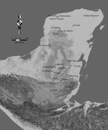
Yaxnohcah is situated in the heart of the Central Karstic Uplands (CKU), an area in the center of the Yucatan Peninsula with an elevation of 180–430 m.a.s.l. (Figure 1). The physiography of the region consists of rocky limestone ridges and undulating well-drained uplands, amidst low-lying karst depressions with seasonal wetlands (bajos). The immense, northwest-to-southeast-oriented Bajo Laberinto, a regionally dominant physiographic feature, includes a drainage break with a primary westward flow to the Candelaria River system running into the Gulf of Mexico, and an eastward flow originating near Yaxnohcah, eventually running into the Hondo River system and the Caribbean.
Map of the location of Yaxnohcah in the Central Karstic Uplands. Map by Reese-Taylor.

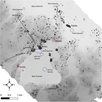
The dense settlement of Yaxnohcah covers over 42 km2 and spans an upland ridge between the Bajo Laberinto to the north and the smaller Bajo Tomatal, lying to the south of the primary civic precinct (Figure 2). The Bajo Tomatal covers some 4 km2 and is situated at a higher elevation than Laberinto, into which it seasonally sheds runoff.
Map of Yaxnohcah showing the location of the Helena and Grazia complexes, as well as causeways and major water reservoirs. Map by Reese-Taylor and Flores Esquivel.

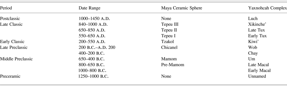
Since 2011, the Proyecto Arqueológico Yaxnohcah (PAY) has investigated factors that contributed to the establishment, growth, and success of this urban landscape through LiDAR prospection, ground verification, and archaeological excavations (Anaya Hernández and Reese-Taylor Reference Anaya Hernández and Reese-Taylor2017; Anaya Hernández et al. Reference Anaya Hernández, Peuramaki-Brown and Reese-Taylor2016; Reese-Taylor and Anaya Hernández Reference Reese-Taylor and Anaya Hernández2013a, Reference Reese-Taylor and Anaya Hernández2013b; Reese-Taylor et al. Reference Reese-Taylor, Anaya Hernández, Peuramaki-Brown, Walker and Dunning2016, Reference Reese-Taylor, Anaya Hernández and Kupprat2020; Vázquez López et al. Reference López, Amellali, Hernández and Reese-Taylor2019). The 2014 LiDAR survey of the region disclosed the magnitude and plan of the settlement. A total of 23 civic complexes—including buildings with religious, administrative, or communal functions and large accessible plazas, ideal for public gatherings—have been identified to date, along with numerous roads and water reservoirs (see Šprajc Reference Šprajc2008 for previous work). Excavations by PAY have revealed a sedentary occupation spanning from the Middle Preclassic through the Late Postclassic period (1000 b.c.–a.d. 1400; Table 1).
Yaxnohcah ceramic sequence (Walker Reference Walker, Reese-Taylor, Hernández and Kupprat2020).

While much of the Middle Preclassic activity at Yaxnohcah centered around the Brisa E-Group complex, which formed the heart of the settlement, research results from 2011 to 2019 show that the overwhelming majority of complexes, both in the central precinct and in outlying areas, also originated during the Middle Preclassic. At that time, most of these complexes consisted of extensive, low-lying platforms and were primarily constructed in upland zones near critical resources, such as water or chert-bearing deposits (Reese-Taylor Reference Reese-Taylor, Freidel, Chase, Dowd and Murdock2017:484).
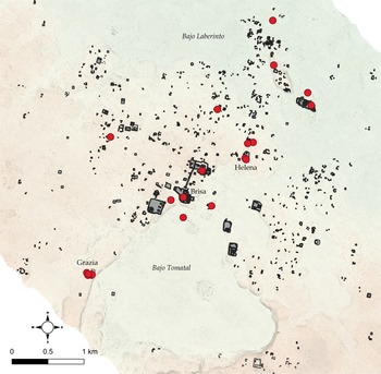
The earliest iteration of these platforms and their associated architecture represent the first sedentary occupation at Yaxnohcah and date to the early Middle Preclassic (1000–650 b.c.), identified based on a limited number of radiocarbon dates, as well as the presence of Macal complex ceramics in isolated contexts (Reese-Taylor Reference Reese-Taylor, Freidel, Chase, Dowd and Murdock2017:484; Walker Reference Walker and Walker2022). We define isolated contexts as those that consist entirely of ceramics from one complex with no admixture of ceramic types associated with other complexes. Macal complex ceramics in isolated contexts have been recovered consistently from the first stratum associated with bedrock leveling in multiple platforms throughout the area (Reese-Taylor Reference Reese-Taylor, Freidel, Chase, Dowd and Murdock2017:484; Figure 3).
Map of Yaxnohcah showing the locations of isolated early Middle Preclassic contexts. Map by Reese-Taylor.

The late Middle Preclassic (650–400 b.c.) occupation of the platforms has been identified based on the presence of Um complex ceramics. These ceramics are recovered in both isolated contexts and with an admixture of earlier Macal complex sherds. In addition to their occurrence in early platforms, Middle Preclassic ceramics (Macal and Um complexes) have been uncovered in agricultural fields, hydraulic features (reservoirs), alluvial deposits of abandoned quarries, and in the construction fill of later structures, suggesting that this early occupation was widespread (Reese-Taylor Reference Reese-Taylor, Freidel, Chase, Dowd and Murdock2017:484–485).
However, the Middle to Late Preclassic transition (400–200 b.c.) is marked by major changes in these platform communities. This transitional period is characterized by ceramics from the Chay ceramic complex. According to Walker and Reese-Taylor, ceramics from this complex include types and individual traits that are found in both the Mamom and Chicanel ceramic spheres (see Walker Reference Walker, Hernández, Peuramaki-Brown and Reese-Taylor2016). During this transitional period, many platforms increased in size, and public architecture, at times monumental in scale, appeared. And by 200 b.c., Yaxnohcah contained numerous civic-ceremonial compounds of different sizes, a complex water management system, and several causeways (Anaya Hernández and Reese-Taylor Reference Anaya Hernández and Reese-Taylor2017; Anaya Hernández et al. Reference Anaya Hernández, Peuramaki-Brown and Reese-Taylor2016; Reese-Taylor and Anaya Hernández Reference Reese-Taylor and Anaya Hernández2013b).
Yaxnohcah's Late Preclassic civic complexes were distributed around the epicenter at varying distances, some of them more than 2 km from the site core (Reese-Taylor et al. Reference Reese-Taylor, Vázquez López, Morton, Peuramaki-Brown, Bednar, Esquivel, Walker, Hernández, Dunning, Freidel, Down, Chase and Murdock2021). Each peripheric civic-ceremonial complex consisted of a low supporting platform in rectangular shape, with distinct structures on it, frequently triadic groups and ballcourts. Triadic arrangements are a temporal marker of the Late Preclassic since the majority of these architectural programs were built during that period (see Doyle Reference Doyle2017; Estrada-Belli Reference Estrada-Belli2011; Hansen Reference Hansen and Houston1998; Szymański Reference Szymański2014; Taube Reference Taube and Houston1998). All of these complexes were associated with the Brisa E-Group in specific ways. A few complexes were connected by causeways and all of the triadic arrangements faced the E-Group (Anaya Hernández et al. Reference Anaya Hernández, Peuramaki-Brown and Reese-Taylor2016; Reese-Taylor Reference Reese-Taylor, Freidel, Chase, Dowd and Murdock2017:484; Reese-Taylor et al. Reference Reese-Taylor and Anaya Hernández2013b). These spatial connections between peripheral nodes and the main civic precinct suggest that the broader urban landscape was integrated into a cohesive social sphere (Reese-Taylor et al. Reference Reese-Taylor, Anaya Hernández, Peuramaki-Brown, Walker and Dunning2016, Reference Reese-Taylor, Vázquez López, Morton, Peuramaki-Brown, Bednar, Esquivel, Walker, Hernández, Dunning, Freidel, Down, Chase and Murdock2021; see also Burham et al. Reference Burham, Inomata, Triadan, MacLellan, Houk, Arroyo and Powis2020). Therefore, by the Late Preclassic period, Yaxnohcah already presented a polycentric urban layout, a development that appears to have stemmed from the autonomous Middle Preclassic communities dispersed throughout the landscape (Anaya Hernández and Reese-Taylor Reference Anaya Hernández and Reese-Taylor2017; Anaya Hernández et al. Reference Anaya Hernández, Reese-Taylor, Peuramaki-Brown, Walker, Dunning, Flores Esquivel, Vázquez López, Morton and Brewer2017; Reese-Taylor et al. Reference Reese-Taylor, Vázquez López, Morton, Peuramaki-Brown, Bednar, Esquivel, Walker, Hernández, Dunning, Freidel, Down, Chase and Murdock2021).
In this article, we focus on two platforms, the Grazia and Helena complexes, that constituted civic nodes during the Late Preclassic. Both platforms were similar in area and volume; therefore, we undertook a program of excavations designed to compare the development of these two complexes during the Preclassic. We propose that each platform was transformed from primarily residential locales to spaces for public gatherings during the Middle to Late Preclassic transition, around 400–200 b.c. We suggest that placemaking rituals integrated these two platform complexes into the social landscape centered around the Brisa E-Group at this time. Specifically, while earlier placemaking acts focused on forging communal identities for residential locales, later acts appeared to reinforce the unique civic role of each of these platform complexes in an emerging urban landscape.
HISTORY AND EXCAVATIONS AT THE HELENA COMPLEX
The Helena complex is situated 900 m to the northeast of the Brisa E-Group complex, to which it is linked by a causeway, and placed on a high ground peninsula on the west side of a strait, or “corridor” of low terrain, connecting the two bajos, Tomatal and Laberinto (Figure 2). The Helena complex was first detected in the digital elevation model (DEM) produced from the 2014 LiDAR survey.
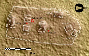
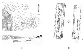
The complex appears modest when compared with the massive, vertical triadic architecture found in other complexes of Yaxnohcah. It consists of a low basal platform, measuring 145 m north–south by 70 m east–west, and rising to a height of approximately 1 m above the surrounding terrain. Seven structures, ranging from 0.50 to 2 m in height, define two distinct sectors in the complex (Figure 4). Three independent, low structures defining a patio dominate the northern end of the platform, while a more formal, civic arrangement of four mounds is found in the south. The later cluster seemingly corresponds to a ballcourt, as it consists of two parallel mounds, Structures Y23-23 and Y23-24 (previously designated Structures H-5 and H-7, respectively), measuring approximately 15 m in length with a longitudinal axis oriented north–south. The eastern mound is 1 m and the western mound 80 cm in height from the surface of the basal platform, with a space of approximately 7 m between them. These parallel structures are flanked on either end by larger platform mounds with an east–west orientation, Structure Y23-22 to the north and Structure Y23-25 to the south (previously designated as Structures H-4 and H-6, respectively). The northern structure measures 16 m east–west, the southern structure measures 25 m east–west, and both are approximately 3 m in height from the platform surface.
Map of the Helena complex showing the location and extension of Suboperations 18A-I, 18J, and 23. Map by Flores Esquivel.

Platform (Operation 18, Suboperations A–I)
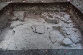
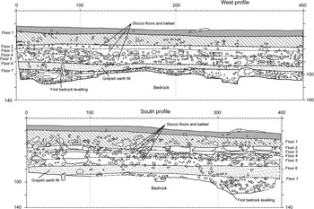
Investigations in the complex began in 2015 and were focused on the southern sector of the Helena complex, where a small test pit of 1.5 m x 1.5 m (Suboperation 18A) was made a few meters to the north of Structure Y23-23 (Flores Esquivel Reference Flores Esquivel, Anaya Hernández, Peuramaki-Brown and Reese-Taylor2016). The main objective of the initial excavations was to obtain stratigraphic and chronological information. However, in the original test unit (Suboperation 18A), an early Middle Preclassic stratum with numerous large sherds was uncovered just above the bedrock, which lay less than 1 m below the surface. Excavations were expanded to reveal this early occupation. In 2019, the extent of these excavations at Helena (Suboperations 18A–I) covered a horizontal area of 4.5 × 4 m (Figures 5–7; Flores Esquivel Reference Flores Esquivel, Anaya Hernández and Reese-Taylor2017, Reference Flores Esquivel, Reese-Taylor, Anaya Hernández and Kupprat2020; Flores Esquivel and Vázquez López Reference Flores Esquivel, Vázquez López, Vázquez López, Anaya Hernández and Reese-Taylor2019). Despite the shallow depth of the Helena platform, Suboperations 18A–I exposed a complex stratigraphic sequence of cultural activities, ranging from the earliest occupants of Yaxnohcah during the early Middle Preclassic to the Early Classic.
Helena complex, Operation 18, Suboperations A–I. An overview of completed excavations, view to the east. The early Middle Preclassic platform and residential structure appear on the right. Photograph by Flores Esquivel.

Because of the irregular bedrock, the deposits that created the earliest surface above the bedrock at Helena fluctuated in thickness from 25 cm to 1 cm and were comprised of at least three different types of fill, with varying densities of compacted sascab and limestone inclusions. While very few artifacts were found in the hard, dense fill in the southwestern suboperations, higher frequencies of both ceramics and lithics were recovered from the northern suboperations. Ceramics recovered from the fill of the latter were identified as types belonging to the Macal complex (early Middle Preclassic, 1000–650 b.c.). A carbon sample was recovered from the platform fill just above bedrock in Suboperation 18E, located in the northern sector of the excavations, and yielded a date of 800–540 cal b.c. (95.5 percent confidence).
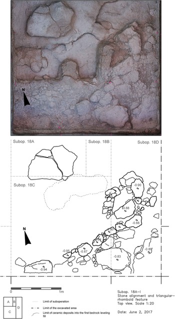
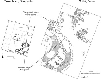
Atop the leveled surface (Floor 7) in the southern suboperations, the early settlers constructed a one-course high, slightly arced alignment of rough-shaped limestone blocks, possibly the edge of a low terrace or the retaining wall of an early wattle-and-daub house. A triangular arrangement of shaped limestone blocks abutted the exterior of the retaining wall (Figure 6). Although smaller in size, this triangular feature is analogous to the outer hearth ring surrounding an early fire pit in direct association with an early residential structure at the site of Colha, northern Belize (Figure 7). While the Yaxnohcah feature had no traces of carbon or carbonized material, abundant carbon was recovered from the Colha feature that yielded a date of 910 cal b.c. (Potter et al. Reference Potter, Hester, Black and Valdez1984:628). Also, unlike the early Middle Preclassic residences at Colha, no burials were found beneath the living surfaces in the early construction at Helena. Nevertheless, the investment in platform and superstructure construction at Yaxnohcah likely signals a shift to permanent settlements during this early period.
Helena complex. Retaining wall and triangular arrangement of an early Middle Preclassic residential structure. Drawing and photograph by Flores Esquivel.

Colha triangular feature (Potter et al. Reference Potter, Hester, Black and Valdez1984:629) compared to Helena complex residential structure. Drawing by Flores Esquivel.

The platform was remodeled during the succeeding late Middle Preclassic (650–400 b.c.) and Late Preclassic periods (400 b.c.–a.d. 200). A layer of dark-gray earthen fill, capped with very few stone inclusions and a tamped earthen surface (Floor 6), covered the earliest levels and raised the level of the Helena platform by around 10 cm. A carbon sample associated with this stratum yielded a date of 410–360 cal b.c. (85.8 percent confidence). A series of four, deteriorated plaster floors were constructed above the gray earthen fill (Floors 2–5). A carbon sample obtained from just beneath Floor 4 yielded a date of 360–150 cal b.c. (92.9 percent confidence).
The final renovation of the Helena platform is comprised of a very deteriorated plaster floor (Floor 1; Figure 8). Ephemeral debris mixed with sediment accumulated atop this stratum. No carbon is associated with these levels and artifacts are very poorly preserved. The few identifiable ceramics recovered from beneath Floor 1 were assigned to the Kiwi’ ceramic complex dating to the Early Classic period (a.d. 200–550).
Helena complex, stratigraphic sequence of Suboperations 18A–I. Drawing by Flores Esquivel.

Ballcourt (Operation 18, Suboperation J)
Suboperation 18J was a 2 × 2 m unit placed in the center between the two low parallel structures (Y23-23 and Y23-24) to the southeast of Suboperations 18A–I (Flores Esquivel Reference Flores Esquivel, Reese-Taylor, Anaya Hernández and Kupprat2020). The principal objective of this excavation was to determine if this formal architectural arrangement constituted a small ballcourt. A secondary objective was to confirm the chronological data gathered in Suboperations 18A–I.
The earliest stratum was placed directly atop the bedrock, which was reached at between 1.25 and 1.5 m below the surface. The fill of this stratum was leveled to create a flat platform surface and was comprised of an admixture of sascab and small to medium rocks and pebbles, similar to the sascab and limestone conglomerate fill encountered in the earliest deposits of Suboperations 18A–I. Ceramics associated with this fill deposit are early Middle Preclassic Macal types.
A layer of loosely compacted sandy grey fill with few pebble and gravel inclusions capped the underlying sascab and conglomerate fill. Identifiable ceramics recovered in this stratum are also associated with the Macal complex.
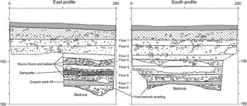
A plaster floor (Floor 6) was encountered directly above the loose sandy gray fill. An alignment of three limestone blocks placed directly on top of Floor 6 was encountered near the east profile of the excavation unit. The blocks were well-shaped and consistent in size, measuring approximately 30 × 20 × 9 cm. They were aligned following the north–south orientation of the Helena platform and the contours of the ballcourt visible on the surface, and it is clear that they continued outside the boundaries of the excavations. Ceramic types from the Macal, Um, and Chay complexes were encountered in association with the stone alignment, Floor 6, and the fill beneath them. It is quite possible that this alignment defines the ramp or banquette of the eastern platform in an early version of the ballcourt, as the stone alignment is parallel to succeeding features that define the edges of later ballcourt platforms.
Subsequent remodeling of the platform included plaster Floors 4 and 5. Suboperation 18J Floors 4–6 correspond to Suboperations 18A–I Floors 2–6 (Figure 9). As previously mentioned, carbon samples recovered in Suboperations 18A–I provided dates of 410–360 cal b.c. (Floor 6) and 360–150 cal b.c. (Floor 4) that place these construction episodes in the transitional Middle to Late Preclassic period (Walker Reference Walker, Hernández, Peuramaki-Brown and Reese-Taylor2016, Reference Walker, Reese-Taylor, Hernández and Kupprat2020). The relatively large quantity of ceramics recovered during the excavation of Suboperation 18J Floors 4–6 are an admixture of types from the Um (650–400 b.c.) and Chay (400–200 b.c.) complexes.
Helena complex, stratigraphic sequence of Suboperation 18J. Drawing by Flores Esquivel.

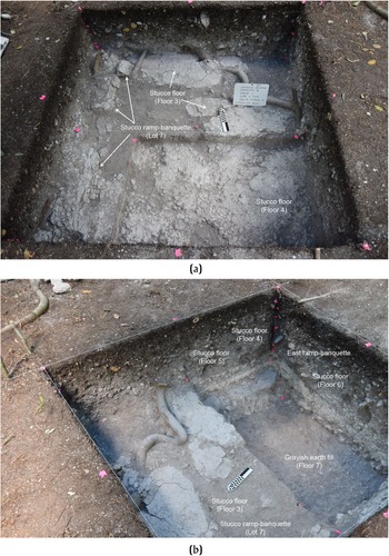
Above Floor 4, an architectural feature with a 45° slope was encountered along the western wall of the unit sitting directly atop Floor 3, a deteriorated plaster surface. This architectural feature was also aligned from north to south, parallel to the orientation of the Helena platform, and appears to be the western ramp of a later ballcourt. This second ramp is located 40 cm above and 1.5 m to the west of the ramp/banquette of the earlier ballcourt. The exposed edge of this late ramp measures 20 cm in height, 30–40 cm from the western wall of the unit, and clearly extends beyond the northern and southern limits of the excavations (Figures 10a and 10b). The ramp surface consists of a well-smoothed stucco coating over a prepared layer of rough mortar and stucco that was applied to a limestone block armature. These blocks were crudely carved into a roughly rectangular shape, measuring approximately 20 × 15 cm. Ceramics belonging to the Chay complex were recovered in association with the ramp and Floor 3.
Helena complex, Suboperation 18J, architectural features: (a) west ramp; (b) east ramp. Photographs by Flores Esquivel.

This feature was covered by at least two subsequent plaster floors (Floors 1–2). Both floors were extremely deteriorated, and no other alignments were encountered in the excavations associated with them. Given the location of the visible parallel structures, it is probable that Floors 1 and 2 were part of the playing alley in at least one later ballcourt construction that shifted to the west. Both Floors 1 and 2 are associated with sherds belonging to the Early Classic Kiwi’ complex.
Northern Sector (Operation 23, Suboperation A)
Another suboperation was located in the northern sector of the Helena platform, a few meters to the northeast of Structure Y23-22. The excavations consisted of a 2 × 2 m unit and revealed three plaster floors and a paleosol over bedrock, which was reached at 1.2 m beneath the surface (Haggard Reference Haggard, Anaya Hernández and Reese-Taylor2017). The few ceramics recovered from the paleosol were Middle Preclassic types, while all three plaster floors were associated with Late Preclassic ceramics.
Summary
The excavations in the Helena complex revealed a complex history of occupation and activities from the early Middle Preclassic to the Early Classic within very shallow deposits. The initial constructions at the complex included the leveling of the natural bedrock in the southern section of the complex to create a platform surface. Subsequently, at least one residential structure was constructed atop this early platform. Renovations of the platform continued throughout the Middle Preclassic, and the function of the platform appears to have shifted during the transition from the Middle to the Late Preclassic period. At this time, it seems likely that an early ballcourt was constructed in the southern sector, replacing the Middle Preclassic residence, which may have moved to the northern sector. Evidence suggests that renovations of the ballcourt ensued during the Late Preclassic and into the Early Classic, as at least three versions of the ballcourt ramp have been identified, including the structures visible on the surface. Finally, the Helena basal platform appears to have been expanded to the north during the Late Preclassic. The northern section of the Helena platform was also renovated at least three times during the Late Preclassic.
HISTORY AND EXCAVATIONS AT THE GRAZIA COMPLEX
The Grazia complex is located about 2 km southwest of the main civic precinct Brisa and is the hub for the residential settlement in this zone. Like the Helena complex, Grazia was first detected in the DEM produced from the 2014 LiDAR survey and was verified in the field during the 2015 season. The complex is situated on an escarpment overlooking the Bajo Tomatal, which lies 100 m to the east (Figure 2), and as a result, the complex rises 24.5 m above the bajo floor (Reese-Taylor et al. Reference Reese-Taylor, Vázquez López, Morton, Peuramaki-Brown, Bednar, Esquivel, Walker, Hernández, Dunning, Freidel, Down, Chase and Murdock2021).
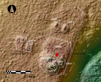
A causeway, located 0.62 km northwest of Grazia, would have facilitated the movement from this zone to the central civic precinct. The buildings in the Grazia complex are situated on a low, rectangular supporting platform aligned north-south, measuring 160 m (N–S) by 60 m (E–W) and approximately 2 m in height (Figure 11), with an elevated tier in the southern section. A ballcourt is located in the northern, lower portion of the platform. It is comprised of two elongated mounds, approximately 2 m in height, and covers an area of around 16 m (N–S) by 12 m (E–W), with an alley of approximately 7 m in width.
Map of the Grazia complex showing the location and extension of Operation 20. Map by Flores Esquivel, modified by Vázquez López.

The elevated tier in the southern sector of the platform (U26-6), has a base area of around 70 m (N–S) by 60 m (E–W) and rises approximately 2 m above the floor of the lower platform. A triadic complex, comprised of a platform with a T-shaped base (Structure U26-8) supporting three smaller structures in a triangular arrangement (Structures U26-7, U26-9, and U26-10), sits on the southern edge of the elevated tier. Structure U26-9 (previously known as Grazia Str. 1a), the apex structure of the triad, is situated on the southern edge of the elevated platform base and towers 8 m above the plaza floor and 10 m above the surrounding terrain to the south. The Grazia triadic group faces north towards the central precinct and is oriented 14° east of north, which is also the orientation of several civic complexes at the site's center (Anaya Hernández et al. Reference Anaya Hernández, Peuramaki-Brown and Reese-Taylor2016; Reese-Taylor et al. Reference Reese-Taylor, Anaya Hernández, Peuramaki-Brown, Walker and Dunning2016, Reference Reese-Taylor, Vázquez López, Morton, Peuramaki-Brown, Bednar, Esquivel, Walker, Hernández, Dunning, Freidel, Down, Chase and Murdock2021).
Since 2016, excavations have been conducted at the base of the platform along the centerline. Interestingly, chert nodules, fragments, and complete tools, most of them showing exposure to heat, appear in high densities from the earliest to the most recent strata, while the earlier cultural strata contain very few to no sherds (Vázquez López Reference Vázquez López, Hernández and Reese-Taylor2017a; Vázquez López and Shaw Reference Vázquez López, Shaw, Reese-Taylor, Hernández and Kupprat2020). Recently, Carr (Reference Carr, López, Anaya Hernández and Reese-Taylor2019:187–188) identified various chert quarries on the edge of the Bajo Tomatal, approximately 470 m to the southeast of the center of Structure U26-9 in the Grazia complex, which are likely the source of the Grazia chert. The chert quarries and the high frequency of nodules, fragments, and complete tools recovered from the architectural fill indicate that chert played an important role in the life of the inhabitants of this area and the development of the Grazia community.
Southern Platform and the Triadic Group
The investigations in the Grazia complex have focused on the plaza at the base of the triadic group. The initial objectives were to obtain information on the chronology and sequence of occupation (Vázquez López Reference Vázquez López, Hernández and Reese-Taylor2017a). The excavations were located right at the base of the staircase of the triadic group, on its central axis (Operation 20; see Vázquez López Reference Vázquez López, Hernández and Reese-Taylor2017a; Vázquez López and Shaw Reference Vázquez López, Shaw, Reese-Taylor, Hernández and Kupprat2020).
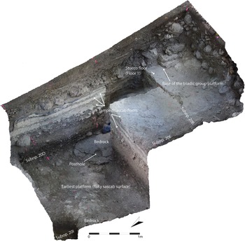
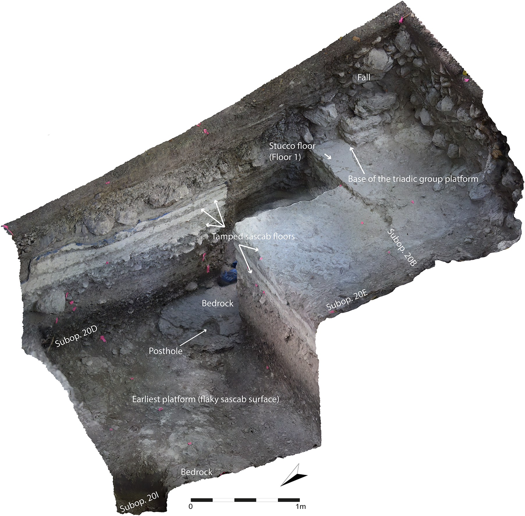
Initial construction in the Grazia complex consisted of bedrock modification, using both natural limestone bedrock and flaky, light gray-white sascab mixed with grey sediment, to create a level surface (Floor 9). A posthole, approximately 15 cm in diameter, located on the surface of the bedrock, was uncovered during the excavations (Suboperation 20D), suggesting that the earliest buildings on the platform were made of perishable materials (Figure 12). The light gray-white sascab used to level bedrock surfaces is also seen in the earliest deposits in Brisa and Helena (Flores Esquivel Reference Flores Esquivel, Anaya Hernández and Reese-Taylor2017; Morton Reference Morton, Hernández, Peuramaki-Brown and Reese-Taylor2016).
Grazia complex, Suboperations 20D, E, and B. Adjusted photogrammetric model showing the first construction that corresponds to the leveled bedrock and a posthole. Model by Vázquez López.
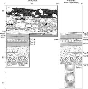
The second construction, superimposed over the modified bedrock, was built using two layers of fill. The lower stratum consisted of an admixture of sascab, a very dark, gray sediment, likely extracted from the nearby bajo, and a high density of flat limestone cobbles and gravel. The builders also included a large amount of lithic debitage within the construction fill (Figure 13). Above this stratum, a fill of sascab, dark clay, and gravels and cobbles increased the height of the platform by approximately 20 cm. The compacted surface of the upper stratum may have constituted a floor (Floor 8) associated with a second platform (Figure 13).
Grazia complex, Suboperation 20B. Drawing of the south profile and partial west profile showing the stratigraphic sequence, including the fill layer of the second construction that may have been associated with Floor 8. The west profile shows a stone alignment associated with Floor 7. Drawing by Vázquez López.

Very few sherds were recovered from these two fills, which strongly contrast with the high amount of small chert flakes contained in them. Some of the sherds have been identified as types associated with the Macal complex, possibly dating this platform to the early Middle Preclassic (1000–650 b.c.; Walker Reference Walker, Reese-Taylor, Hernández and Kupprat2020).
Above the dark gray fill and Floor 8, the builders laid a light gray and compacted fill and a thin layer of ballast, topped with a tamped sascab floor (Floor 7). Excavations revealed an alignment of stones in the southeastern sector of the unit associated with Floor 7 (Figure 13). The construction fill beneath Floor 7 contained ceramic types associated with the Chay complex in the southeastern sector of the excavations, which suggests a date of 400–200 b.c.
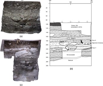
Significantly, in the northern sector of the excavations, a small hearth (Hearth 2) was uncovered. Hearth 2 was placed in an oval cut into Floor 7, within a gray matrix containing small cobbles and gravel, along with abundant fragments of carbon. The hearth was formed by small limestone cobbles, and also contained a large amount of ash. Samples were taken for radiocarbon dating, but results are pending. Unfortunately, Hearth 2 was exposed in the northern profile of the excavation unit at the end of the season and further work is needed to fully reveal the feature (Figures 14a–14c).
Grazia complex, Suboperation 20D. (a) Adjusted photogrammetric model showing Hearth 2 inserted into Floor 7; (b) drawing of the north profile, showing Hearth 2 and the alignment of stones that covered it; (c) adjusted photogrammetric model of Suboperation FH, showing Altar 2, the north profile of Suboperation 20D, and Hearth 2. Drawing and models by Vázquez López.

Hearth 2 and Floor 7 were covered with a thin layer of fill that is similar to that in which the hearth is located; however, it contained a large number of sherds and charcoal fragments, along with lithics. It is possible that this fill, which is also somewhat compact, may have constituted a poorly preserved surface that was not identified during the excavation, representing an additional construction episode in the platform.
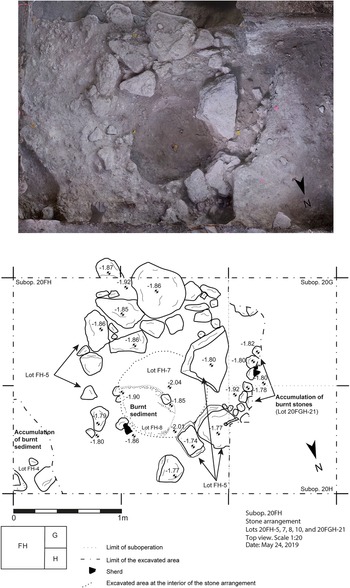
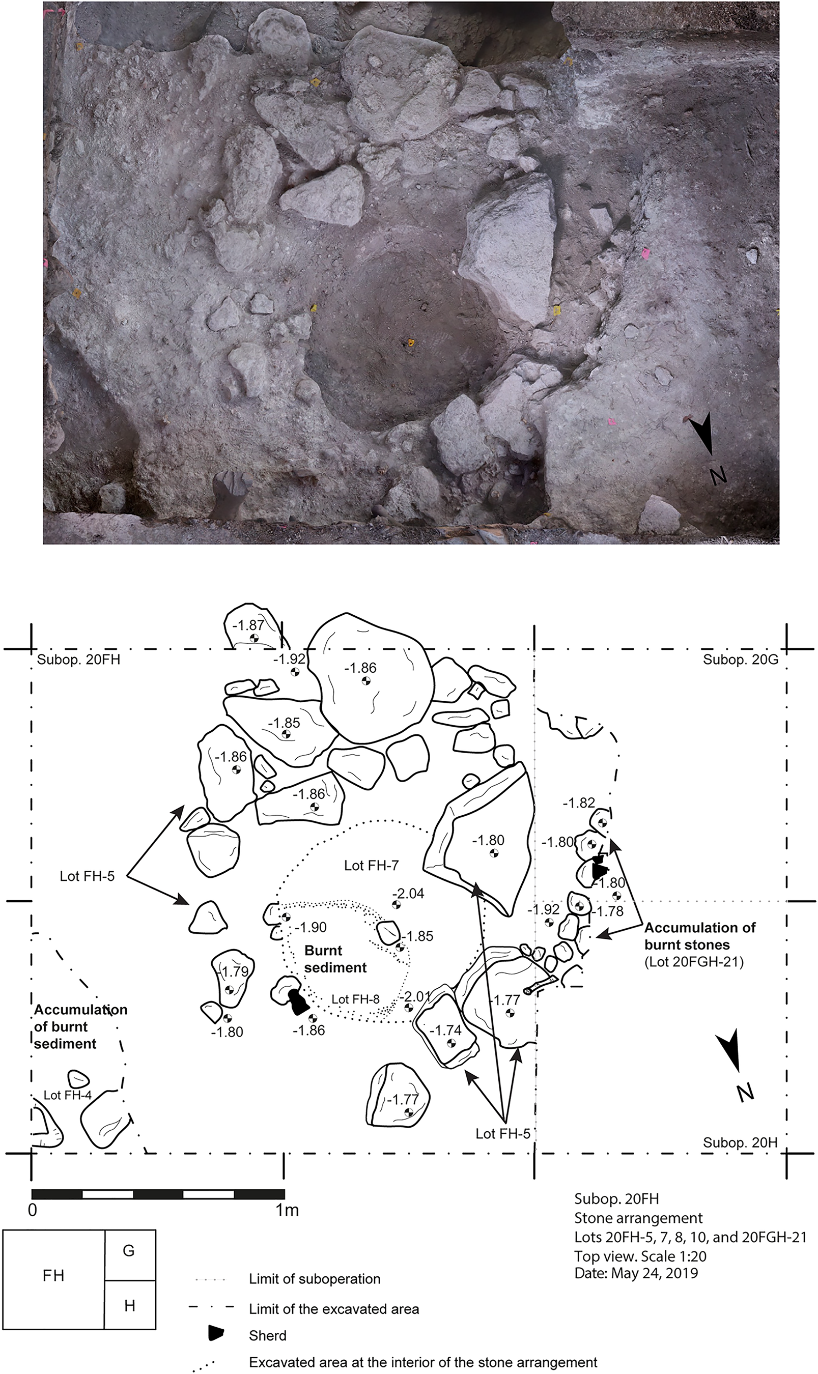
Atop this fill and directly above Hearth 2, the builders laid one course of large, roughly shaped limestone blocks (Suboperation 20D). Further excavation revealed that this stone alignment was part of an irregular oval arrangement (Suboperation 20FH; Figures 14a, 14b, and 15). At the center of the stone oval, the team uncovered burnt sediment, containing a few sherds of significant size—although none formed partial vessels—and some pestle (mano) fragments. A pile of small and medium-sized burnt small limestone cobbles (ca. 5–10 cm in diameter) was located to the west, right outside the oval. These burnt lots were located approximately 20 cm above Hearth 2 (Suboperation 20D). The sherds recovered from this burnt sediment, including a fragment from a Juventud Red vessel, have been identified as a mixed assemblage of ceramic types from both the Um and the Chay complexes. This admixture of ceramic types is much like several assemblages recovered from the Helena complex and place the burning activity during the transitional period between 400 and 200 b.c. Based on this evidence, there is no doubt that burning activities were conducted in this area over a long period of time.
Grazia complex, Suboperation 20FH. Adjusted photogrammetric model and drawing showing the oval arrangement of stones, with burnt sediment concentrations and some scattered sherds. Drawing and model by Vázquez López.
A construction fill containing numerous small to large limestone rocks, mixed with a light gray soil, was placed above the surface on which the stone oval sat. This fill was capped with a surface made of tamped sascab (Floor 6, Suboperation 20D; Figure 14b). However, it appears as though Floor 6 did not completely cover the stone oval feature and the burnt lots.
While the ballast of Floor 6 contained ceramic types that could be placed in the Chay complex (400–200 b.c.), the subjacent fill—which is associated with the fill above Hearth 2—included types of sherds commonly found in the Wob complex (200 b.c.–a.d. 200). A carbon sample from the fill context (Lot 20D-22) produced a date of 180–1 cal b.c. (95 percent confidence). The Wob complex sherds and the radiocarbon date firmly situate this construction in the later facet of the Late Preclassic.
A series of additional Late Preclassic tamped sascab floors were superimposed upon the earlier platform associated with Floor 6 to elevate the platform (Floors 5, 4, 3, and 2, in chronological order). Some of these floors correspond to renovations of very eroded previous floors. The fill of each construction episode consisted of a sascab and clay matrix, mixed with varying frequencies of cobbles and gravel. Artifacts, including ceramic sherds and lithics, were also recovered from these fills.
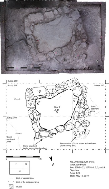
Immediately above the stone oval described above (Suboperation 20FH), yet another tamped sascab surface (Floor 5, Suboperation 20FH) was discovered. A massive limestone block rested on this floor. The monolith (Altar 2) had an irregular shape, measuring 1.40 × 0.90 × 0.20 m, and was surrounded by an alignment of mostly roughly cut limestones on each side that formed the low walls of a containment box (Figure 16). In some sections, the walls were two courses in height, especially towards the north, where it was necessary to compensate for the slope of the platform. Floors 3 and 4 were cut to place Altar 2 on Floor 5. Interestingly, the stone monolith is not aligned with the triadic group, but oriented to magnetic north, suggesting that an earlier structure may underlie the platform of the triadic group.
Grazia complex, Suboperation 20FH. Adjusted photogrammetric model showing Altar 2 surrounded by a stone frame. Three concentrations of burnt sediment are shown, one of which was documented outside the northeastern corner of the frame. It contained several fragments of the same vessel and other sherds. Drawing and model by Vázquez López.

No formal hearth was associated with Altar 2, at least in the immediately surrounding area, but accumulations of burnt stones and sediment found in direct contact with the block indicate that burning activities were conducted there, nevertheless. These burnt traces seem to have been part of hearths that were removed or cleaned by the former inhabitants. Three concentrations of burnt stones and sediments associated with the monolithic feature were identified: (1) in the northwest corner of the block, directly in contact with the outer side of the north wall, (Suboperation 20FH); (2) approximately 50 cm northeast of the east wall (Suboperation 20H); and (3) immediately west of the west wall (Suboperation 20G). Altar 2, surrounded by walls, and the associated concentrations of burnt sediments suggest that the altar and hearth complex was becoming a focus of increasingly complex and structured ritual activities.
The ceramic assemblage associated with Altar 2 contains an admixture of types found within the Chay and Wob complexes, suggesting that the feature dates to 200 b.c.–a.d. 200. While some of the sherds have Chay modes, a concentration of sherds, identified as types found exclusively in the Wob complex, were recovered from the northwestern corner of the altar, in association with an accumulation of burnt stones. These ceramics include several fragments that belong to the same vessel. It is possible that a hearth was placed in this sector, which would explain the sherd concentration and the burnt stones recovered (Figure 16).
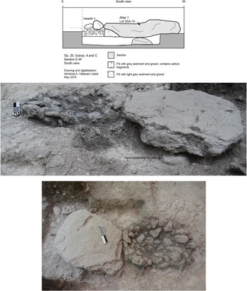
At some later point, but still during the Late Preclassic period, the plaza underwent a final remodeling that included a thin stucco floor (Floor 1) covering yet another oval-shaped hearth and a large block of limestone (1.00 × 0.65 × 0.15 m). This altar and hearth complex (Altar-Hearth 1) was placed in the central axis of the triadic group, embedded in the plaza floor, about 2.5 m north of the staircase that leads to the triadic group and less than 1 m south of Altar 2 (Figure 17). To construct this feature, the builders cut into the surface of Floors 2 and 3. The hearth was placed directly on the tamped sascab surface of Floor 3 (Vázquez López Reference Vázquez López, Hernández and Reese-Taylor2017a:18, 20–21). The ceramics recovered from the upper layers of the hearth have been identified as types belonging to the Chay and Wob complexes.
Grazia complex, Suboperation 20A. Profile drawing and photos of Altar-Hearth 1. Drawing and photographs by Vázquez López.
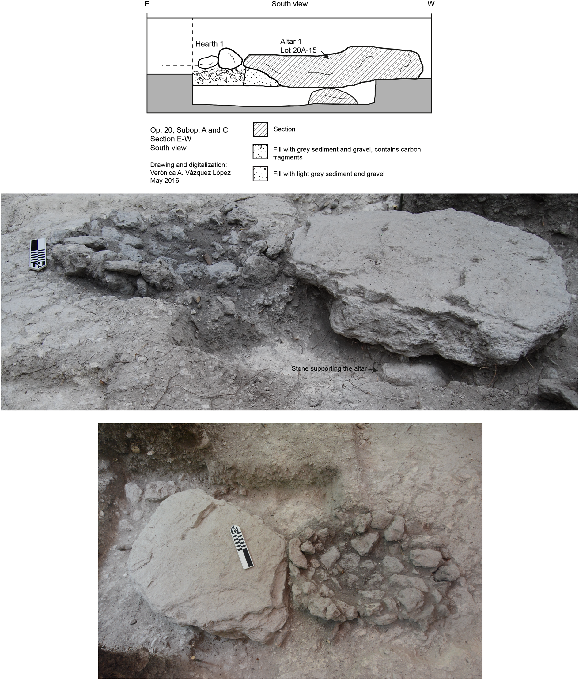
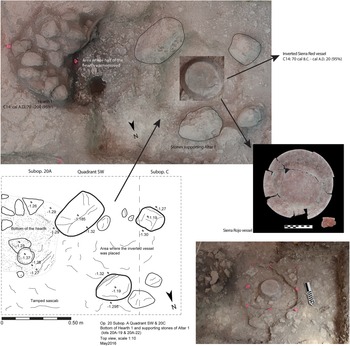
While the hearth was placed on Floor 3, the altar was supported by three medium-sized stones arranged in a triangular layout, which were laid directly atop an earlier sascab surface (Floor 4). In the center of the triadic stone arrangement, we encountered a Sierra Red offering plate, placed upside-down. This offering was covered by the large altar stone (Figure 18). Due to the strategic location of Altar-Hearth 1, situated on the plaza and aligned with the center of the main structure of the triadic group, we suggest that the hearth and the cache constitute a single ritual tableau associated with burnt offerings. The Grazia altar seems to be a (less-elaborate) precursor of the Classic (a.d. 200–750) period three-legged altars, such as the Late Classic Altar 1 from Piedras Negras (a.d. 550–750), a massive monolithic disk with three support legs whose inscription narrates the myth of creation at the “first three-stone place.”
Grazia complex, Suboperation 20A. (a) Orthophoto of the western half of Hearth 1 (eastern half had already been removed); (b) drawing of Hearth 1 and adjacent stones in a triangular arrangement, originally supporting the altar slab; (c) and (d) photos of the Sierra Red bowl placed upside down below the altar, with C14 date of 70 cal b.c.–cal a.d. 20 (95 percent). Drawing and model by Vázquez López; photograph detail of the Sierra Red vessel by Debra Walker.

Two carbon samples taken from the hearth and from the cache provide firm, late facet, Late Preclassic dates for the Altar-Hearth complex. The carbon sample taken from the hearth yielded a date of cal a.d. 70–220 (95 percent confidence), while the sample associated with the offering vessel yielded a date of 70 cal b.c.–a.d. 20 (95 percent confidence). These dates suggest the cache may have been placed prior to the burning activity associated with the hearth. It is also possible that the hearth was re-used over a long period of time and that the sample corresponds to a later activity.
In the final construction act on the Grazia platform, the inhabitants covered this complex with a stucco surface (Floor 1). The ceramics collected from the surface and the layer of fall from the triadic group indicate that the complex may have been used until the Late Classic—ceramics with modes from the Kiwi’ and Tux complexes have been identified. However, no further plaza construction or modification took place after the Late Preclassic (Walker Reference Walker, Reese-Taylor, Hernández and Kupprat2020).
Summary
The excavations in the Grazia complex revealed construction episodes from the Middle Preclassic to the Late Preclassic. Although it appears that the area was still in use during the Early and Late Classic periods, no construction activity has been identified. Rather, intense ritual activity appears to have peaked during the Preclassic.
The first occupation consists of an early platform formed through the modification and augmentation of the bedrock. Subsequently, the inhabitants raised the level of the platform using a mixture of sascab, gravel, and dark gray clay, which might have been brought from the Bajo Tomatal. This fill also contained many small chert nodules and chipped chert debitage. Platform renovations continued during the transition from the Middle Preclassic to the Late Preclassic until the end of the Late Preclassic.
The triadic arrangement, the ceramic assemblage, and the radiocarbon dates indicate that the principal occupation of this complex dates to the Late Preclassic period. Compelling evidence for burning activities on several surfaces demonstrates the repetition of fire ceremonies over hundreds of years, from the very late part of the Middle Preclassic to the end of the Late Preclassic.
The evolution of the area includes a period of transition in which a social shift occurred from possible residential to public architecture, the latter being marked by the triadic group and probably the ballcourt. The earliest hearth has been documented in a stratum that precedes the triadic group, and subsequent burning events integrating the altar and hearth complexes (Altar-Hearth 1 and Altar 2) suggest a continuity of ritual practices and the incorporation of Grazia into a more complex landscape during the Late Preclassic.
DISCUSSION
Excavations at Grazia and Helena have revealed distinct types of placemaking activities. While the evidence at Grazia illustrates the importance of fire rituals over time—many associated with the triadic group—the ballgame at Helena emerged as a focus of ritual activity towards the beginning of the Late Preclassic. These placemaking acts arise at contemporaneous points in the culture history of Yaxnohcah and seem to serve a similar function, transforming residential complexes into public spaces, a shift that is particularly apparent at Helena. These acts influenced the ways in which the inhabitants interacted, creating a new sense of place focused on a community identity.
According to McAnany (Reference McAnany and McAnany2010) and Estrada-Belli (Reference Estrada-Belli, Burger and Rosenswig2012), monumental and other forms of specialized architecture strengthen community bonds and change the dynamics of social relations by fostering public interaction and cohesion (see also Anderson Reference Anderson and Braswell2012; Anderson et al. Reference Anderson, Robles Castellanos, Andrews, Kathryn Brown and Bey2018; Helmke et al. Reference Helmke, Christopher, Morton and Wrobel2015; Vázquez López Reference Vázquez López2017b, Reference Vázquez López2019). According to Rowlands (Reference Rowlands1993) and McAnany (Reference McAnany and McAnany2010:142), new spaces are created in a physical sense, as well as in a social sense, often as expressions of power relations and archives of social memories.
In this case, monumentality is not so much defined by the dimensions or the centrality of the new loci, but by functions in terms of communal cohesion reflected both in the construction event and subsequent usage (see Burham et al. Reference Burham, Inomata, Triadan, MacLellan, Houk, Arroyo and Powis2020; Pauketat Reference Pauketat2007; Pollock Reference Pollock1999:175). The triadic group of Grazia is not as colossal as those of complexes located in the epicenter (e.g., the Alba and Carmela complexes), and neither is the ballcourt at Helena, but both constitute examples of monumental architecture, as they establish places in the landscape that define people and their histories (Pauketat Reference Pauketat2007:199).
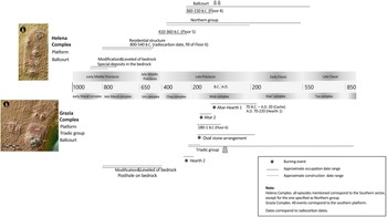
Helena Complex
As argued above, the Helena complex has a well-defined early occupation dating to the early Middle Preclassic period (1000–650 b.c.), as evidenced by the presence of early Macal complex ceramics and a radiocarbon date of 800–540 cal b.c. (Figure 19). Activity at Helena during this early period included bedrock leveling and the construction of what may correspond to a house. The platform was remodeled at the beginning of the Late Preclassic (Floor 6, with a radiocarbon date 410–360 cal b.c.) and at least four more times during the same period (Floors 2–5). These three subsequent modifications of the platform correspond to the period in which the ballcourt was built, replacing the Middle Preclassic residential area, which may have been shifted to the northern part of the platform. The platform and the ballcourt were used through the Early Classic.
Timeline of major construction events and ritual activities at the Helena and Grazia complexes. Illustration by Vázquez López; maps by Flores Esquivel.

The latest version of the Helena ballcourt complex consists of an I-shaped arrangement, common to the Maya Lowlands (Anderson Reference Anderson and Braswell2012; Flores Esquivel Reference Flores Esquivel, Anaya Hernández, Peuramaki-Brown and Reese-Taylor2016:68–69; Scarborough and Wilcox Reference Scarborough and Wilcox1991; Uriarte Reference Uriarte1992; Whittington Reference Whittington2001). Ballcourts of this type have two parallel structures that define the playing alley and two structures placed at each of its extremes, and, when viewed from above, the spaces between the four structures in the complex form a capital “I” shape. I-shaped ballcourts are found throughout Mesoamerica, from the Late Preclassic to the Late Classic period (Scarborough and Wilcox Reference Scarborough and Wilcox1991; Uriarte Reference Uriarte1992; Whittington Reference Whittington2001). In the Maya Lowlands, I-shaped ballcourts appear to be a Late Preclassic phenomenon associated with larger settlements that were the center of ritual activity for a region.
Nearby examples similar to Helena—albeit on a larger scale—and of comparable date include the Carmela ballcourt, located 1.25 km to the southwest, as well as Structure 50, the southern ballcourt at Cerro Maya (Flores Esquivel and Šprajc Reference Flores Esquivel and Šprajc2008; Scarborough et al. Reference Scarborough, Mitchum, Carr and Freidel1982). While the Carmela ballcourt is unexcavated, ceramics identified as types within the Tulix complex recovered from the Structure 50 ballcourt date it to between 200 b.c. and a.d. 200 (Vadala and Walker Reference Vadala and Walker2020), coeval with the Wob ceramic complex at Yaxnohcah. Three I-shaped ballcourts are also found in El Mirador: one in the Grupo León, one in Grupo Colomte, and one in the Grupo Tres Micos (Mejía and Velázquez Reference Mejía, Velázquez, Arroyo and Méndez2013:Figure 4; Morales-Aguilar et al. Reference Morales-Aguilar, Hansen, Douglas and Prado2015:9). While the form of these ballcourts is consistent with the final layout of the Helena ballcourt, we do not know if the earlier versions of the ballcourt included buildings to the north and south of the playing alley. In addition, the scale of these ballcourts is significantly different from that of the Helena ballcourt, which has parallel structures of 0.8–1 m in height that form a playing alley of approximately 7 m wide, based on measurements taken prior to excavation.
However, a remarkable likeness exists between the Helena ballcourt and the northern ballcourt, Structures 2C, D, and E, at Cerro Maya (Reese Reference Reese1996; Figure 20a). Two parallel structures, approximately 0.8 m in height, and a low mound to the north form a small, open-ended, T-shaped ballcourt. (Reese Reference Reese1996). Excavations also revealed a lower sloped bench, 0.25 m in height, and an upper terrace, which was set back about 1 m from the interior edge of the lower bench. The face of the upper terrace sloped back from the lower bench at a 50° angle. The alleyway consisted of a hard plaster floor, 10–15 cm thick and approximately 4.5 m wide.
(a) Cerro Maya ballcourt. Drawing by Kathryn Reese-Taylor. (b) Xanila ballcourt; the northern mound of the T-shaped ballcourt arrangement does not appear in the drawing. Drawing by Donato España and Edgar Medina, courtesy of Edgar Medina and Fernando Robles Castellanos.

The majority of ceramic types recovered from the deteriorated area in the alleyway of the northern Cerro Maya ballcourt also date to the Tulix period (200 b.c.–a.d. 200), and many belong to the Late Tulix termination subcomplex, a group of ceramics which co-occur only in termination contexts (Reese Reference Reese1996). However, approximately 20 percent of the ceramics recovered from the excavations were from later periods, suggesting that the ballcourt remained a focus of ritual activity during the Early Classic (Hubul phase, a.d. 200–450), Terminal Classic (Sinhal phase, a.d. 850–1150), and Early Postclassic (Kanan phase, a.d. 1150–contact) (Reese Reference Reese1996). This is consistent with the dating of the final construction episode in the Helena complex. Sherds from the Kiwi’ complex (a.d. 200–550) recovered from the upper stratum in the Helena ballcourt suggest an Early Classic date for the final construction and ritual use of the space.
Both the Helena ballcourt and the northern ballcourt from Cerro Maya fall within the range of variation noted for ballcourts in the Northwestern Lowlands (Anderson et al. Reference Anderson, Robles Castellanos, Andrews, Kathryn Brown and Bey2018; Medina Castillo Reference Medina Castillo, Robles Castellanos and Andrews2003, Reference Medina Castillo2005; Medina Castillo and Lawton Reference Medina Castillo and Lawton2002; Robles and Ligorred Perramon Reference Robles Castellanos and Perramon2008). Twenty-five ballcourts were encountered during a survey of sites near Merida by the Proyecto Costa Maya and Proyecto Salvamento Arqueológico Ciudad Caucel (Anderson et al. Reference Anderson, Robles Castellanos, Andrews, Kathryn Brown and Bey2018). All ballcourts were of a diminutive size. The two parallel structures bounding the play alley were generally 1.2–1.6 m in height; however, Medina Castillo (Medina Castillo and Lawton Reference Medina Castillo and Lawton2002:282) noted that earlier constructions may have been less than 1 m in height. The playing alleys measured 14–25 m in length and 3–10 m in width. Excavations of the ballcourt at the site of Xanila revealed two parallel structures and a northern end mound (T-shaped; Figure 20b). The eastern structure included a low bench; an apron rose from the bench at a slope of 12°. No upper wall was encountered (Anderson et al. Reference Anderson, Robles Castellanos, Andrews, Kathryn Brown and Bey2018:203–206).
These ballcourts consistently date to the Middle Preclassic period, based on ceramics recovered from surface collections and excavations. Also, they were situated in sites that were in the second tier of the regional settlement pattern (Anderson et al. Reference Anderson, Robles Castellanos, Andrews, Kathryn Brown and Bey2018). Anderson and colleagues (Reference Anderson, Robles Castellanos, Andrews, Kathryn Brown and Bey2018:214) argue that the ballgame and the construction of ballcourts was not controlled by elites during this period, but was in the hands of local communities. Moreover, resources and labor necessary to build ballcourts of a modest size were readily available in small communities, implying that ballcourts may have originated as a ritual sport used for community cohesion.
On the other hand, the Nakbe ballcourt, first constructed at the end of the Middle Preclassic (500–400 b.c.), is situated in the heart of a prominent Middle Preclassic civic precinct, immediately south of the eastern E-Group platform (Hansen Reference Hansen and Houston1998; Velásquez Reference Velásquez, Laporte, Escobedo and Brady1992). The two parallel structures are 2 m in height and the playing alley is 5 m in width. The final construction phase of the ballcourt dates to the Late Preclassic. An east–west oriented structure sits at the southern end of the playing alley at least by this period—and perhaps earlier—forming a T-shape. The location of the Nakbe ballcourt suggests that the ballgame was associated with elite rituals during the late Middle Preclassic, in contrast to the ballcourts in the Northwestern Lowlands.
Although other ballcourts at Yaxnohcah may be more comparable to the Nakbe example, the data from the Helena ballcourt complex resonates with that from the Northwestern Lowlands. As the Helena complex transitioned from primarily domestic to public space, the initial steps during the period 400–200 b.c. may have involved the local community coming together to build a ballcourt, similar to Middle Preclassic ballcourt construction in the north. Placemaking rituals would have fostered a sense of community among local inhabitants.
During ensuing generations, the population in the Yaxnohcah area expanded and centralized rule emerged, likely by 200 b.c. Former community rituals were adopted by elites to legitimize their rule. Larger ballcourts, such as those in the Carmela complex and north of the Brisa E-Group complex, were constructed in the central precinct. However, smaller “community” ballcourts, such as those in the Helena and Grazia complexes, were integrated into the landscape as well. While the ballgame remained the focus of ritual activity at Helena, the arrangement of the I-shaped ballcourt, with its larger end structures, suggests that ballgame rituals were becoming more formalized and codified, and somewhat grander, as Helena is integrated into Yaxnohcah's increasingly urban landscape.
Grazia Complex
In Grazia, as in Helena, the major construction phases identified include the initial modification of the bedrock and renovations to increase the size of the platform in at least five subsequent episodes. The final arrangement of the complex included a triadic group at the southern end of the basal platform. Repeated ritual activities have been detected in association with most of the modifications.
The evidence for ritual practices is attested in the material remains of altars, a cache, and features related to burning activities, such as hearths and accumulations of burnt sediment and stones. In Grazia, radiocarbon dates recovered from fill above Hearth 2 suggest that rituals involving burning commenced 180–1 b.c. (Figure 19), at the latest. However, it is quite likely that fire rituals began much earlier, as ceramics recovered from a burned deposit to the west of the stone oval feature, approximately 20 cm above Hearth 2, have been identified as a mixed assemblage of types from both the Um and the Chay complexes, suggesting a date of 400–200 b.c.
Significantly, all ritual deposits were placed in the same location in the plaza—at the base of the triadic group in the same axial line—emphasizing the importance of the specific location in which these ceremonies were conducted through time. While further excavations in the Grazia plaza might reveal more extensive ritual deposits, the location of these deposits uncovered along the center axis line of the staircase is noteworthy. These fire rituals and their attendant special deposits, no doubt, contributed to the creation of “place” and a sense of community identity.
Triadic groups are characteristic of the Late Preclassic period (Doyle Reference Doyle2017:71–108; Estrada Belli Reference Estrada-Belli2011:67–82; Hansen Reference Hansen and Houston1998:75–81; Szymański Reference Szymański2014; Taube Reference Taube and Houston1998). Doyle states that triadic architecture became the center of communal construction—as the focus of monumental building efforts related to communal projects—towards the end of the Late Preclassic (Doyle Reference Doyle2017:102).
The appearance of monumental architecture is related to a new level of community integration. Thus, places with monumental architecture, such as triadic complexes, were locales where inhabitants interacted and developed a feeling of belonging to a community. Shared rituals and ceremonies—beyond the household level—played an important role in the production and reproduction of social relations and the creation of community identity (see Yaeger Reference Yaeger, Canuto and Yaeger2000).
According to Inomata and colleagues, rituals contribute to the construction of social relations and their meaning, through the experiences of the participants (Inomata et al. Reference Inomata, Triadan, Román, Ruiz, de León and Cuerva2010:30; see also Bell Reference Bell2009[1997]; Pauketat Reference Pauketat2007). Ritual practices, like quotidian practices, are a medium for the production and negotiation of power in relationships (Bell Reference Bell2009[1997]:76–83). Specifically, the ritual complex involving hearths and altars, situated at the base of the Grazia triadic group, explicitly demonstrates the symbolic equivalency of triadic groups, hearths, and three stone places, which speaks to the incorporation of fire rituals and altars into the public discourse of the political ideology that emerged during the Late Preclassic.
Examples of altars, caches, and ritual practices associated with monumental architecture are reported in several sites throughout Maya history. It is common to find caches associated with monumental architecture on the medial axis of buildings, at the summit of a platform, or in the staircases, as has been reported for the triadic groups of Cerro Maya—Structures 4, 5, 6, and 29—during the Late Preclassic period (Tulix phase, 200 b.c.–a.d. 200; Vadala and Walker Reference Vadala and Walker2020).
Caches were placed in the construction fill of buildings, as well as in plazas, which frequently involved cutting through earlier floors (see Coe Reference Coe and Gordon1965; see also MacLellan Reference MacLellan2019). Numerous caches were found in the E-Group plaza at Ceibal—in the central east–west axis of Structures A20 and A10—and included lip-to-lip or upside-down red vessels, stone spheres, and small disks dating to Late Preclassic and Protoclassic (Inomata et al. Reference Inomata, Pinzón, Palomo, Sharpe, Ortíz, Bauer and Román2017).
Examples of Preclassic caches with a single red vessel, like the one recovered under Altar 1 at Grazia, or lip-to-lip vessels, abound in sites all over the Maya area—for example, Tikal, Uaxactun, and Holmul in the Peten; Altun Ha, Cerro Maya, Cuello, K'axob, Nohmul, Barton Ramie, San José, Río Nuevo, and Santa Rita in Belize; and Altar de Sacrificios and Ceibal in the Pasión river region (Bazy and Roldán Reference Bazy, Roldán and Palomo2013; Coe Reference Coe1990; Gann Reference Gann1918; Gerhardt Reference Gerhardt1988; Hammond Reference Hammond1985, Reference Hammond, Grove and Joyce1999; Hammond and Gerhardt Reference Hammond, Gerhardt and Hammond1991; Harrison-Buck Reference Harrison-Buck and McAnany2004; Inomata et al. Reference Inomata, Triadan, Román, Ruiz, de León and Cuerva2010; Krejci and Culbert Reference Krejci, Culbert and Grube1995; McAnany and López Varela Reference McAnany and López Varela1999; Merwin and Valliant Reference Merwin and Valliant1932; Ortíz et al. Reference Ortíz, Pinzón, Méndez, Arroyo, Paiz and Mejía2012; Pendergast Reference Pendergast1979, Reference Pendergast1982, Reference Pendergast and Mock1998; Pinzón and Román Reference Pinzón, Román, Román and Inomata2010; Ricketson and Ricketson Reference Ricketson and Ricketson1937; Robertson Reference Robertson and Walker2016; Román Reference Román, Román, Inomata and Triadan2009; A.L. Smith Reference Smith1950, Reference Smith1972, Reference Smith1982; R. Smith Reference Smith1931; Thompson Reference Thompson1939; Walker Reference Walker and Mock1998, Reference Walker2013; Willey et al. Reference Willey, Bullard, Glass and Gifford1965).
In many cases, cache vessels include only fine-grained sediments—similar to the sediments recovered from the Sierra Red cache vessel at Grazia—possibly because they were filled with organic contents. For instance, the majority of the caches of K'axob contained only fine-grained sediments (McAnany and López Varela Reference McAnany and López Varela1999).
However, one Late Preclassic/Protoclassic (200–50 b.c.) deposit from K'axob, which was placed into a thick plaza floor, included three unshaped chunks of limestone at the bottom of the vessel (McAnany and Varela Reference McAnany and López Varela1999:162). This three-stone cache demarcated the transition of a single dwelling to a multi-dwelling complex. McAnany and López Varela (Reference McAnany and López Varela1999:162) suggest that the three-stone cache might be a reference to creation myths and the primordial three-stone hearth (Freidel et al. Reference Freidel, Schele and Parker1993:82, 112; Taube Reference Taube and Houston1998). Although the morphology of this cache is quite distinct from the Grazia deposit, it appears to be symbolically equivalent.
The location of the cache associated with Altar-Hearth 1 at Grazia, inserted into a floor, beneath the latest occupational surface, and close to the apparent central axis of the triadic group, suggests that the offering constituted a dedicatory deposit (see Coe Reference Coe and Gordon1965:463–464). Offerings associated with built structures and set into plaza floors are commonly encountered in ceremonial architecture, such as triadic groups and E-Groups (e.g. in Ceibal, Cival), from the Middle Preclassic to the Postclassic. Therefore, it is possible that the final ritual deposit of the triadic group of Grazia was linked to construction activities related to the reflooring of the plaza.
Altars have also been recorded all over the Maya world, from the Middle Preclassic to Late Postclassic periods, as they are significant components of Maya ritual life. At times, monolithic altar stones (rounded, circular, rectangular, quadrangular, or concave) are covered with stucco or carved with iconographic motifs or hieroglyphic texts. Often these are paired with stelae to form altar-stela complexes. Also, monolithic altars (rounded, circular, or irregular) with flat surfaces may be supported by three or four stones, resembling traditional Maya domestic kitchen hearths (see Taube Reference Taube and Houston1998; see also Chase Reference Chase, Chase and Rice1985 for Postclassic altar types).
At the base of Structure 6 at Cerro Maya, a Late Preclassic monolith with two—likely three—postholes were placed in the central axis of the staircase (see Reese Reference Reese1996:53, Figure 2.19). Reported as a banner stone, its shape resembles that of an irregular altar monolith. Likewise, Monument 8, a Late Preclassic monolith with a central posthole, was also recovered from Nakbe (Hansen Reference Hansen, Laporte and Escobedo1994:326). Monument 8 is a rounded stone with a double-headed serpent carved on its top surface. Hansen (Reference Hansen, Laporte and Escobedo1994:326) mentions that the monolith could be an altar or a ballgame marker.
At Naachtun, the Early Classic Altar 15—an irregular, semi-rounded, shaped monolith—was found at the base of Acropolis V-Structure V in Group C, in the central axis of the staircase (Nondédéo et al. Reference Nondédéo, Begel, Rojas, Nondédéo, Michelet, Begel and Garrido2018:386–387). Two ritual deposits were placed under Altar 15 (Nondédéo et al. Reference Nondédéo, Begel, Rojas, Nondédéo, Michelet, Begel and Garrido2018:387). In Naachtun's Group A, at the base of the central axis of Structure XXIIIb—the east structure of an E-Group—Altar 14 was found. This altar has a circular shape and dates to the Early Classic period. Two caches were recovered during the excavations, one directly under the altar (Hiquet Reference Hiquet, Nondédéo, Michelet, Begel and Garrido2018:54–56).
Examples of rounded altars sitting on three or four supports, similar to a comal resting on three or four stones (Taube Reference Taube and Houston1998:442), have also been recovered from Classic period contexts. Altar 4 of El Cayo, Chiapas (a.d. 731) literally depicts this arrangement in a carved representation of an altar resting on three supports—rendered in a profile view—with a censor on its surface (Mathews and Aliphat Reference Mathews and Fernández1997:100–102). Another Late Classic example is Altar 1 from Piedras Negras (a.d. 692; Martin and Grube Reference Martin and Grube2008:146), a massive monolithic disk with three support legs whose inscription narrates the myth of creation at the “first three-stone place.” This altar was located in front of the Acropolis on the West Group Plaza, although not in its central axis. Smaller, uncarved round monoliths supported by three stones and dating to the Terminal Classic and Postclassic periods have also been reported in Chichmuul, Chancacab, and Las Panteras in Quintana Roo (Harrison Reference Harrison, Shaw and Mathews2005:223–224).
Evidence of burning activities—mainly expressed archaeologically by burnt vessels, artifacts, and sediments—are associated with ritual practices and frequently accompany caches. Fire was and continues to be of great significance in Maya ritual deposits or ceremonies. During the Classic period, rituals involving fire were frequently conducted in connection with architectural features or buildings, as recorded in dedicatory expressions on public monuments (Stuart Reference Stuart and Houston1998). Ethnographic studies report that several Maya communities, as well as other Mesoamerican groups, believe that fire and smoke—produced by the means of burning candles, incense, food, drinks, seeds, and other elements, or lightning firebrands—provide the house and other buildings (i.e., temples) with a soul force and sustenance, a notion related to the feeding of the gods (Durán Reference Durán1971:149; Guiteras-Holmes Reference Guiteras-Holmes1961:26; McGee Reference McGee1990:44; Redfield and Villa Rojas Reference Redfield and Villa Rojas1964:146–147; Vogt Reference Vogt1969:461–465). Specifically, Stuart (Reference Stuart and Houston1998:394–395) suggests that Classic hieroglyphic texts symbolically equate fire rituals and incense burning within architectural contexts to the “feeding” of buildings, and were often a component within more complex ceremonies that incorporated “feeding” rites. Stuart (Reference Stuart and Houston1998:417) also argues that “placing a fire within a new building figuratively makes it a home by creating a ‘hearth.’ ”
The Grazia Altar-Hearth 1 complex seems to explicitly emphasize the three-stoned primordial hearth in multiple ways: the formal oval hearth and the triadic arrangements of both the configuration of the altar, which is supported by three stones, and the triadic architecture of the complex. While the earlier altars, hearths, and other burning activity areas at Grazia do not present a formal triadic arrangement, they still convey the significance of fire rituals within the Grazia community during the Preclassic.
The appearance of public and monumental architecture in the Grazia complex, expressed by the triadic group and the ballcourt, as in the case of the Helena complex, marks the transition to a public space, involving the local inhabitants in communal construction projects and ritual action. The triadic group of Grazia constituted a locus for collective religious and possibly economic activity, and placemaking rituals, which prominently included burning ceremonies, would have strengthened a sense of place and community identity among local inhabitants. Communal ritual activities would have been of great significance during the period in which outlying communities, such as Grazia, were incorporated into a more complex sociopolitical and urban landscape.
CONCLUSIONS
Excavations at Helena and Grazia have revealed specific life histories of place. Both groups began as levelled terrains formed through the modification of the bedrock, probably for residential structures, as indicated by a posthole in Grazia and a more formal house platform in Helena. There is no evidence of public use of these spaces prior to the late Middle Preclassic.
During the transition to the Late Preclassic, both places were transformed and acquired new meaning, encouraging a more public expression of community. The symbolic and functional shift is particularly visible through the appearance of monumental architecture, such as temples and ballcourts, as well as a series of ritual hearths and altars, most of them associated with the new architecture. In this context, the Helena and Grazia ballcourts represent community-driven efforts establishing a purpose-oriented place, where sport, both as a ritual and as a social activity, served as glue for the social network. Fire ceremonies in the Grazia complex probably had the same function, especially when considering their association with the triadic group. Therefore, both architectural arrangements—ballcourts and triadic groups—embody public construction projects, communal rituals, and, possibly, public sports—a potential setting for public spheres that might have played an important role in the creation of collective identities and negotiation of social relations (Bell Reference Bell1992; Bourdieu Reference Bourdieu1977; Giddens Reference Giddens1984; Hendon Reference Hendon2010; Inomata et al. Reference Inomata, MacLellan and Burham2015; Mills and Walker Reference Mills and Walker2008; Pauketat Reference Pauketat2007).
The social transformation of local communities interacting in a more complex urban landscape may have led to the development of strategies that allowed individuals to identify themselves as members of communities in a larger arena. Placemaking practices created a sense of place, and, significantly, place attachment, resulting in multiple scales of integration from the local community to a broader territorial unit that included other peripheral complexes and the main civic precinct of the Brisa E-Group, and finally, perhaps, to a regional level (see Martin and Beliaev Reference Martin and Beliaev2017; Tokovinine Reference Tokovinine2013).
In sum, placemaking rituals evolved from intimate activities that bonded small residential communities to those that created public spaces for a growing populace. Moreover, this shift in placemaking rituals seems to have occurred rapidly at Yaxnohcah around 400 b.c., likely reflecting major sociopolitical transformations, including the emergence of centralized power and growing social inequality, that were taking place throughout the Maya Lowlands at this time. These changes involved not only the creation of new places in an urban landscape that united a widespread territory, but also the transformation of small communal spaces that had meaning for local residents into nodes that, while still locally meaningful, were also crucial for establishing a new identity associated with the emerging state, reconfiguring the sense of place among the Maya.
RESUMEN
Las excavaciones arqueológicas de Yaxnohcah han revelado una secuencia de ocupación sedentaria entre el 1000 a.C. y el 1400 d.C., con periodos dinámicos de crecimiento en el preclásico medio (1000–400 a.C.) y preclásico tardío (400 a.C.–200 d.C.).
Hacia finales del preclásico medio e inicios del tardío, el paisaje estaba salpicado con plataformas bajas y extensas construidas en zonas elevadas y cerca de fuentes críticas para la subsistencia y el desarrollo de los grupos arquitectónicos, como reservorios de agua y canteras de pedernal y caliza.
En este trabajo nos enfocamos en los complejos Grazia y Helena como estudios de caso de los nodos periféricos que experimentaron procesos de transformación hacia el final del preclásico medio, mediante los cuales adquirieron nuevos significados y fomentaron una expresión más pública de la comunidad. Estos cambios se observan, particularmente, en el surgimiento de arquitectura especializada y monumental, como resultado de proyectos de construcción comunitaria y de acción ritual.
En el Complejo Grazia, las excavaciones revelan diferentes momentos constructivos ocurridos durante el preclásico tardío, posiblemente iniciando en el preclásico medio, y evidencia de actividades rituales. En algún momento de esta transición se construyó un grupo triádico, en cuya base encontramos depósitos rituales en distintos niveles de ocupación, y trazas de actividades de quema, lo que sugiere la importancia de estas prácticas para la comunidad por su repetición en el tiempo. Algunos depósitos rituales presentaron altares monolíticos y concentraciones de quema, mientras que uno, además del altar y el fogón, presentó una vasija. Consideramos que estas prácticas rituales constituyeron elementos integradores de la comunidad local.
El Complejo Helena presenta un desarrollo desde el preclásico medio temprano (1000–700 a.C.). La ocupación más temprana se asocia con la modificación de la roca madre y la posterior construcción de una plataforma habitacional. En la transición del preclásico medio al tardío se construyó una cancha de juego de pelota, lo que dotó al conjunto de una arquitectura de carácter público.
La construcción de plataformas monumentales, canchas de juego de pelota y grupos triádicos implicaron dinámicas sociales nuevas, vinculadas a la manera en que las comunidades interactuaron y se integraron con el paisaje, lo cual se asocia con las prácticas de creación y significación del lugar (placemaking). Mediante estas prácticas se generó un sentido de pertenencia al lugar y de identidad comunal en un nuevo paisaje sociopolítico, donde los rituales jugaron un papel significativo.
ACKNOWLEDGMENTS
Investigations at Yaxnohcah were carried out with the permits issued by the Instituto Nacional de Antropología e Historia de México and were supported by grants from the Social Sciences and Humanities Research Council of Canada, the National Science Foundation, and the University of Calgary. We would also like to thank Jerry Murdock and Venture Capital Partners for their support of the LiDAR survey. We are also thankful for the ongoing support of the University of Calgary, the Universidad Autónoma de Campeche, and the University of Cincinnati. We are grateful for our team of researchers and local workers from the communities of Concepción, Conhuas, Constitución, and Pablo García, in Campeche. We thank Joshuah Lockett-Harris, Jessica Shaw, and Mikaela Radford, who conducted excavations in the Grazia complex and its residential area, and Debra S. Walker for her analysis of the ceramic assemblages from the excavations. We also thank Felix Kupprat for his insights and comments. We want to thank the three anonymous reviewers for their insights, suggestions, and comments that enriched the article.
The senior author thanks the Consejo Nacional de Ciencia y Tecnología (CONACyT) and its program of postdoctoral fellowships, “2do Año de Continuidad de Estancias Posdoctorales en el Extranjero Vinculadas a la Consolidación de Grupos de Investigación y Fortalecimiento del Posgrado Nacional,” Convocatoria 2019 (1).