The ability to move easily, particularly between the workplace and home, underlies our commonly held assumption about the foundation of salubrious suburbs. The early suburbs of British colonial Bombay (now known as Mumbai) were predicated on the ability of a tiny European elite to move to different parts of the city according to the seasons. By the mid-nineteenth century the movement of elite Europeans would no longer be restricted to the several islands that constituted Bombay. Instead, tracing the governor's footsteps they would move many miles away from Bombay to different locations as the seat of governance shifted according to the season. In Bombay itself, in the late nineteenth century, the growth of the mill industry would force Europeans to retreat to other areas of the city from their former suburban homes, which were now transformed into mill districts.Footnote 1
In contrast to the freedom of movement that underlay the early foundation of European suburban development in Bombay, this article shows that middle-class Indian suburban development was based on the necessity to flee the crowded and insalubrious native city districts. The bubonic plague that first struck the city in 1896 was most virulent in the native districts of the city, long subject to municipal neglect. After 1896, large numbers of Bombay's native citizenry were forced to flee their homes each year during the plague season. Moving to different locations, often along the railway lines, they formed small communities that became the foundation of Bombay's future suburban development. Rather than a planned expansion of the city, this article argues the centrality of movement – the freedom to move, the inability to move and being forced to flee – to the suburban development of Bombay. This is not to suggest that planning and movement were opposed to each other in this type of suburban growth, but rather that planning efforts often followed, rather than preceded, the movement of populations.
Scrutinizing the term ‘suburb’: the freedom to move
The term ‘suburb’, applied to colonial India, deserves closer scrutiny as a form and historical process. In his study of suburbanization in the US, Kenneth Jackson has argued that ‘suburbanization as a process involving the systematic growth of fringe areas at a pace more rapid than that of core cities, as a lifestyle involving a daily commute to jobs in the center, occurred first in the United States and Great Britain, where it can be dated from about 1815’.Footnote 2 In 1815, most cities of the world were ‘walking cities’.Footnote 3 In the early nineteenth century, centred on the Fort, Bombay was also a walking city. Bombay followed the model of many places in Western Europe where elite residences were built in the country in the eighteenth and early nineteenth centuries. The move to the suburbs may have begun by the late eighteenth century, and certainly by 1838, Bombay had suburbs where elite Europeans resided and commuted to their jobs in the Fort.Footnote 4
The Fort, whose walls were constructed in 1715 or 1716, formed the nucleus of colonial settlement in Bombay well after the Fort walls were torn down after 1862. In theory, the Fort was itself divided into two sections along racial lines: the British lived in the south and the Indians, of the predominantly wealthy class, lived in the north (see Figures 1 and 2). In 1750, some of the well-known houses occupied by Europeans to the north of the Fort included the Villa Nuova at Mahim, owned by Thomas Whitehall, the old Mark House in Mazagaon, rented to Thomas Byfield by the government in 1750, and the governor's house at Parel. Governor Hornby was the first to reside there from 1771 to 1780.Footnote 5 According to James Douglas, in 1750 and much earlier, there ‘must have been many residences, country houses of rich Portuguese and others at Mazagon’.Footnote 6
Island of Bombay, 1909, plan. From The Gazetteer of Bombay City and Island, compiled by S.M. Edwardes, 3 vols. (Bombay, 1909), vol. I, frontispiece.

Fort of Bombay from Belmont, view. From Anon., Life in Bombay, and the Neighbouring Out-Stations (London, 1852).

British military officers lived south of the Fort in Colaba in huts and tents and it was only in the last quarter of the eighteenth century that a military cantonment was formally established here.Footnote 7 Colaba itself was one of the seven islands that came together to form Bombay and was only connected to Bombay in 1838 with the construction of the Colaba Causeway. In their low densities, and planned layouts, cantonments may remind us of planned nineteenth- and twentieth-century suburban development in Western Europe and the United States. However, the cantonment was not a suburb of the town of Bombay: movement between the two locations was not encouraged. In colonial India, cantonments were settlements that intentionally segregated the military from the native population and even from the ‘civilian members of the colonial community’. With their own bazaar, the attempt was to make cantonments self-sufficient. Troops were to find that ‘“the first order that appeared when you got to a new station stated that all Indian villages, Indian shops, Indian bazaars and the civil lines were out of bounds to all troops”’.Footnote 8
However, it is difficult to say whether Europeans settled outside the Fort in large numbers before 1750. It is likely that the occupation by the governor of his house in Parel from 1771 onwards encouraged Europeans to move there. Marianne Postans, who authored several books on western India, used the word ‘suburbs’ in 1838 to describe these settlements.Footnote 9 By 1852, one observer commented that ‘a few English families prefer residing in the fort, for the greater convenience it offers in the vicinity to the offices’, implying that most resided outside the Fort by then. At this time, Malabar Hill in the west was still comparatively undeveloped, as the governor's bungalow at Malabar Point was referred to as ‘a rural retreat’.Footnote 10
In 1803, a fire devastated a third of the Fort, which forced the British to carry out some long-planned changes in the city. By 1750, a new town was coming into existence north of the Fort walls, but it was only after 1803 that a native town was established up in that area.Footnote 11 The significance of the fire lies in the expansion of a native town beyond the Fort walls. Delineating the boundaries of the native town in 1880 in his guidebook to Bombay, James Maclean stated that it was situated north of the Fort beyond the Esplanade, and extended up to Grant Road, which formed its northern limit. Beyond this lay the northern suburbs of Tardeo, Byculla, Mazagaon and Parel, where ‘the European element of the population is again prominent’.Footnote 12 Malabar Hill lay to the west and by the end of the nineteenth century became the most popular place of residence for rich Indians and Europeans. Such a description is conducive to the ‘dual city’ model of colonialism proposed by scholars such as Anthony King and Janet Abu-Lughod, in which ‘white town’ and ‘black town’ form separate entities. Recent work by Swati Chattopadhyay has challenged this formulation for colonial Calcutta, showing that despite popular perception of separate enclaves, the everyday lives of the European and Indian populations intersected at multiple levels to create a more complex racialized landscape than the dual city model serves to explain. My own analysis of the census data on the population distribution of Europeans and native populations in various sections of colonial Bombay also reveals that that the ‘dual city’ had no foundation in reality.Footnote 13
Thus, the colonialist view of dual cities skews the understanding of suburban development, as the term ‘suburb’ was used unevenly to describe ‘native’ and ‘European’ settlements outside the city limits. While using Jackson's definition of the suburb ‘as the site of scattered dwellings and businesses outside city walls’, we may describe the expansion of the indigenous settlement north of the Fort as ‘suburban’, yet none of the British authors described this is as a suburb or even a suburb-as-slum, but as the ‘native town’. The received nomenclature should not prevent us from exploring the process of settlement, however.
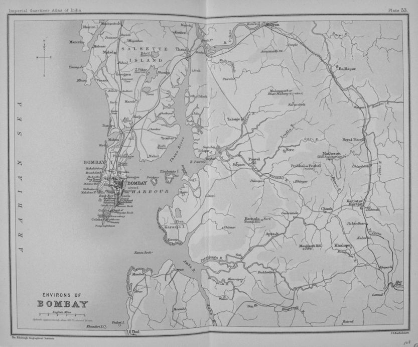
The story of suburbanization in colonial India is further complicated by the movement of the seat of government according to the seasons. Although the Island of Bombay had been under British control since 1661, the British crushed the Peshwa rulers by 1818 and established their dominance in western India, with Bombay as the capital of a vastly extended Bombay Presidency (Figure 3). By the mid-nineteenth century, the British had gained enough control over this region for the governor of Bombay and high government officials to move the seat of governance each year from Bombay to Poona during the monsoons, to Mahabaleshwar before and after the rains and back to Bombay for the cool winter season. Poona and Mahabaleshwar were just two of several ‘sanatoria’ or ‘sanitary stations’ established along this route by the British. The sanatoria, which grew into small settlements, were generally located on tablelands of the Western Ghats where Europeans enfeebled by the heat of the plains could recover (Figure 4 and Figure 10, bottom).Footnote 14
Environs of Bombay. Salsette Island is north of the Island of Bombay. East of Bombay, on the mainland, is Matheran, which is marked as a ‘Hill Sanitarium’ on the map. From The Imperial Gazetteer of India, vol. XXVI, Atlas (Oxford, 1909). © British Library Board, OIH 915.4 plate 53.

Elephant Hill & Traveller's Bungalow, Khandala. From Anon., Life in Bombay, and the Neighbouring Out-Stations (London, 1852).

Governors of Bombay had a long tradition of living in the countryside, a development that tended to encourage others to move to that area. The main motive for this move was supposed to be an escape from the congested and unhealthy conditions of the Fort to the countryside.Footnote 15 However, through movement and the placement of markers, the British gained possession over the countryside. Governor Hornby was the first to move his place of residence from the Fort to the countryside on the Island of Bombay by moving to the Government House at Parel where he resided from 1771 to 1780 (Figure 5). This was formerly a Portuguese place of worship, which the British confiscated from the Jesuits in 1720. The Portuguese were the former owners of the Island of Bombay and British possession of this building signalled their ownership of this island. However, until the governorship of Sir Evan Nepean (1812–18) in the early nineteenth century, governors continued to reside either at the Fort or at Parel.
Government House, Parel, Bombay, view c. early twentieth century. Courtesy Bhau Daji Lad Sangrahalaya, Bombay.

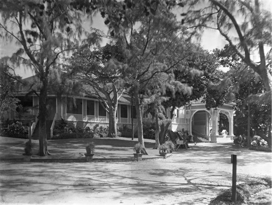
In 1813, the governor Sir Evan Nepean felt that cool sea breeze was necessary for his health and built a room for himself west of the Fort, at Malabar Point, an almost uninhabited part of the island. Subsequent governors added to this and in 1828, the governor Sir John Malcolm gave up the Government House in the Fort and by enlarging this one virtually made it into the Government House (Figure 6). Whereas before 1820 there were only about two villas on Malabar Hill, after this date the presence of the governor attracted many individuals to move to this area and erect villas.Footnote 16 But even as late as 1852, Malabar Hill was still comparatively undeveloped, earning it the epithet ‘rural retreat’.Footnote 17
Government House, Malabar Point, Bombay, early twentieth-century view. Courtesy Bhau Daji Lad Sangrahalaya, Bombay.

While the governors moved their residence to more desirable areas in the Island, in the nineteenth century, a large section of the European population moved their place of residence within the Island of Bombay as the seasons changed. Writing of the year 1838, Mrs Postans observed that during the summer months, many Bombay residents erected temporary bungalows on the Esplanade surrounding the Fort. These were taken down at the onset of the monsoons, and the European residents moved to more ‘substantial dwellings [that] are to be found either within the fort, or at Girgaum, Byculla, Chintz Poogly, and other places beyond the bazaars [native town that had sprung up beyond the Fort], where European residents have erected groups of pucka built [or of masonry construction], and handsome houses, with excellent gardens and offices attached’.Footnote 18
Forced to flee
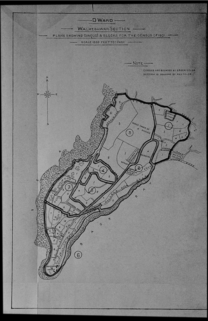
In the 1880s, elite Europeans were forced to flee the northern suburbs and move south-west to Malabar and Cumballa Hills near the governor's second residence. In his memoir, Sir Dinshaw E. Wacha called attention to the ‘radical transformation’ witnessed in the 1880s, as industrialization transformed erstwhile suburbs (Figure 7). In what he called the ‘triple transformation’ of Bombay, this was the third, the first being the levelling of the Fort walls in 1862 that led to the second, the rise of Gothic Revival buildings on that site. In the 1880s, suburbs, with their ‘verdant groves’ and ‘stately trees’ that shaded the villa residences of the ‘ruling hierarchy’ of high government officials, were now being acquired by ‘the new hierarchy devoted to the worship of King Cotton’.Footnote 19 The earliest complaints about the smoke nuisance caused by industrialization were brought forward in 1884.Footnote 20 This nuisance caused the European elite to flee the affected districts. According to Wacha, driven out by ‘industrial capitalism’, ‘civilianism’ now ‘planted itself thickly on the breezy Malabar and Cumballa Hills’. In the meantime, these suburbs ‘were appropriated by the cotton mills and the jerrybuilders of the day found chawls, now reduced to slums, for the accommodation of the growing industrial population’. He also noted that trade had taken charge of the eastern foreshore.Footnote 21 Trade and industry had transformed the countryside to the north, blocked access to the sea on the east, forcing the elite to move south-west (Figure 8).
India United Mills No. 1, a textile mill in Parel, Bombay. The large mills with their prominent chimneys erected after 1854 transformed the landscape of Bombay. Photograph by author, c. 2006.

Walkeshwar, plan, 1901. Walkeshwar includes Malabar Hill. The Government House at Malabar Point is located near the southern tip of the section. From S.M. Edwardes, Census of India – 1901, vol. XI: Bombay (Town & Island), part 5, Report (Bombay, 1901).

In Parel and its vicinity, prominent buildings changed hands as this section of the city transformed. In 1889, the Elphinstone College moved from Byculla (south of Parel) to a spacious gothic building on the Esplanade, while the old college then became home to the Victoria Technical Institute.Footnote 22 Once the governor's rural retreat, the Parel Government House saw its surroundings transformed as a number of mills were constructed in western Parel. In 1883, the wife of the governor died of cholera in the Government House. In 1885, the Governor's House in Malabar Point became the official residence of governors. The abandoned Governor's House in Parel was converted into a plague hospital during the epidemic and by about 1899, came to house the Plague Research Laboratory, formerly located in the J.J. Hospital and overseen by Dr W.M. Haffkine, after whom it was later renamed the Haffkine Institute. The departure of the governors from Parel as a residential location only seemed to hasten the transformation of this section. By the end of the nineteenth century, eastern Parel was highly populated and included GIP Railway workshops, 46 mills and numerous factories (Figure 9).Footnote 23 As mills transformed the environs of the Government House, the hospitals built in its vicinity in the 1920s catered primarily to the labouring populations.
Parel, plan, 1901. The Government House at Parel is located in the top north-east corner of this section. Also note the large compounds of the GIP Railway Workshop and Jacob Mills. From S.M. Edwardes, Census of India – 1901, vol. XI: Bombay (Town & Island), part 5, Report (Bombay, 1901).

In August 1896, plague first appeared in Bombay and soon spread to other parts of the Presidency.Footnote 24 Only after the passing of the Epidemic Diseases Act in February 1897 were a number of public health policies enforced to control the epidemic.Footnote 25 The plague resulted in the flight of a panicked population and great losses in commerce and industry, forcing the authorities to the realization that sanitary reform could not be ignored in the creation of a modern trading and industrial city. A board of trustees created for the improvement of Bombay City began work in November 1898 armed with great powers for clearing insanitary areas and laying out new streets.
The activities of the City of Bombay Improvement Trust (CBIT) were to shape the future growth of the city decisively for over a quarter century.Footnote 26 After 1898, the great powers allotted to the Trust enabled the colonial authorities to penetrate and destroy localities, displace people and erect sanitary structures within the native town and plan for the extension of the city in the northward direction. The constitution and powers of the Trust resembled those of the Port Trust and were based on the model of the Glasgow City Improvement Trust. The Trust was responsible for (1) laying of new roads, (2) improving crowded localities, (3) reclaiming further lands, (4) constructing sanitary dwellings for the poor, (5) providing accommodation for the police.Footnote 27 One method of relieving the congestion of overcrowded areas was through the provision of additional building areas. CBIT Schemes IV, V, VI, and VII were in response to this. Although Scheme IV (Gowalia Tank Scheme, D Ward) and Scheme VII (Colaba Reclamation, A Ward) responded to the western and southern areas of the island, Scheme V (the Dadar–Matunga Scheme for the Sion and Mahim Sections of F and G Wards) and Scheme VI (the Matunga–Sion Sheme for the Sion Section of F Ward) were designed to enable the extension of the city to the northern sections of the Island of Bombay. By 31 March 1902, both Scheme V and VI had been revised and government had sanctioned a section of Scheme V by the end of February 1901.Footnote 28
The displacements brought on by the plague would transform the city in other ways. These transformations include the settlement of the suburbs of Bombay and the creation of new housing colonies segregated along caste, or community lines. Forced to flee the city, the annual displacements produced by the plague would encourage Indians to take up residence in the suburbs. From about December 1897, large numbers of Parsis and upper-class Hindus left the infected parts of the city and moved to the countryside to private camps in the north of the Island of Bombay or to the suburbs of the Salsette Taluka in the Thana District. Salsette Island is north of Bombay. By March 1898, about 45,000 people had moved to the north of the Island of Bombay or to the suburbs in Salsette (see Figure 3).Footnote 29
The plague raged in the city for years producing seasonal and permanent displacement of populations who moved to camps and other places in Bombay or outside the city to escape the plague. Thus like the British elite who had moved around the island in search of better climatic conditions, large numbers of Indians moved from their dense localities during the cold winter months (the plague season) to save their lives.
After the plague attacked Bombay in August 1896, it was estimated that by February 1897, 400,000 inhabitants had fled the city.Footnote 30 The population of Bombay in 1901 was 776,006. Between 1896 and 1901, the plague robbed the city of approximately 200,000 inhabitants, out of which 113,818 had died from the plague.Footnote 31 By 1901, the annual seasonal exodus usually took place particularly from seven sections: the Fort North, Market, Dhobi Talao, Fanaswadi, Bhuleshwar, Girgaum and Chowpatty. In short, six of the seven sections were in the so-called native town. These seven sections had a combined population of 149,102. It was estimated that the loss of population in these sections due to the plague was approximately 54,384.Footnote 32 The inhabitants who migrated annually from their homes fell under three classes. First, there were those who migrated out of the city for several months. Approximately 7,200 people migrated each year for several months from Bombay to Cutch, Ratnagiri and the Southern Maratha country. Second, were those who moved to camps within the city. A population of 14,996 lived in temporary camps set up at Mahim, Dadar, Sion and other places on Bombay Island. Third, those who migrated to places along the two railway lines and daily commuted to work in the city. About 36,000 people – referred to as the ‘Salsette and Thana refugees’ – who lived in places on the BB and CI Railway between Bandra and Virar, and on the GIP Railway between Coorla and Kalyan, and making use of season tickets, commuted daily to work in Bombay.Footnote 33
Unlike cities such as London where suburban movement had the ideological implication of separate spheres of the ‘public’ and ‘private’, and thus promoted a pattern of commuting to work, in Bombay, where the move to the suburbs was primarily precipitated by the plague and sanitary conditions, the commuting pattern was not primarily prompted by the ideological distinction between private and public.Footnote 34
By 1907, there was a housing crisis in Bombay faced by all classes, from the wealthy to clerks and others of lesser means. The housing shortage had resulted in an increase in rents in recent years that threatened to make Bombay a more expensive place to live in than London. The government saw this as a time to tackle the issue of the development of Bombay in a more comprehensive manner.Footnote 35 On 9 December 1907, the government sent a questionnaire to certain Bombay institutions, asking them to respond to questions relating to (1) segregation of areas by income groups, (2) co-ordinating and improving the various channels of communication and (3) the best means of travelling for the population displaced.Footnote 36
The institutions that responded represented the elite of the city: the CBIT, the Municipal Corporation, the Chamber of Commerce, the Millowners’ Association, the Bombay Port Trust, the GIP and BB & CI Railway Companies, the Bombay Presidency Association, the Indian Merchants’ Chamber and the Bombay Native Piece Goods Merchants’ Association. The last-named institution is the only one that gave its unsolicited opinion on the subject.Footnote 37
Each institution replied according to its own interests and yet, based on these responses, the government proceeded in 1909 with a policy that would be implemented in Bombay over the next twenty years. It was recommended to reserve the western shores for the accommodation of the wealthy. Two alternatives considered were rejected – Mahim Woods, for being too distant, and Worli, as the atmosphere had been polluted by sewage disposal schemes. The reclamation of Back Bay was seen to be the only solution for providing additional accommodation for this class and a decision was made to transfer the reclamation rights from the CBIT to the government. No particular localities were reserved for the middle classes since it was assumed that they would move into the areas vacated by the upper classes and to the northern area, which was being developed for those who could afford it. Labourers and factory workers would continue to live near their place of work as their long hours of work demanded and as they would be unable to bear transportation costs.Footnote 38
In 1913, the government appointed a committee to review the development of the town of Bombay, and to study the policies forwarded by the government and the progress made since the report of 1909. The report of this committee was submitted in 1914 and broadly concurred with the policies of 1909. Although it maintained that mills should not be shifted from their current location, it recommended that future mills be located on the north-eastern part of the island expanding into Salsette. The western part of the island was to be reserved for residential purposes. To remedy the overcrowding of the city, it advocated the opening up and planning of land for residential uses, such as CBIT's Scheme V. This indicates that little progress had been made in this scheme up to this point. The report also pointed out that through town planning, Mahim (on Bombay Island) could be developed, but doubted that migration would extend north beyond Andheri (on Salsette).Footnote 39 The government resolution of 1909 appended as Appendix A of the 1914 report contains more detail of the ‘natural areas’ suited for each class. Here it was pointed out that the wealthier classes would prefer to be housed in the west and south-west areas of the island, as close to the Fort as possible. Until labourers and factory workers could afford to pay for transportation, they were to find housing close to the docks and factories. The middle-class worker, on the other hand, who daily commuted to work in the Fort and could afford to pay for the costs of transportation would have to move to the northwest areas of the island and further north into Salsette.Footnote 40 In the case of the middle class, the government was putting into policy what was already a reality for many daily commuters after the plague and the 1914 report was partially based on interviews with witnesses and the trends they foresaw.
Leaving ancestral homelands: moving to the suburbs
The plague camps would have two major effects on the future development of Bombay. First, people would choose to organize themselves on the basis of community and live in ‘segregated’ areas. This formed the nucleus of future suburban development. Second, suburban development would be middle class. The experience of the plague had shown that with the exception of the camp at Dadar, the working class would only move to camps that were located in the city, thus revealing reluctance, or, rather, an inability to move to the suburbs due to the social and financial costs of commuting.
A large number of the new middle-class housing colonies that developed after the second decade of the twentieth century were based around caste or religion as were many plague camps. While communities in Bombay often occupied a lane or lived in specific localities, most lived in localities where diverse communities lived and worked. In his urban biography of the city in 1863, Govind Narayan observed that
Though most of the settlements in Mumbai are fairly mixed, most people prefer to stay close to members of their own caste. If some ten Parsis stay in an area, a Hindu would not prefer staying there . . . Only the English are not bothered to stay amongst their own people. If the area is clean and the air is good, they take up residence in any place.Footnote 41
However, the plague brought about a desire for greater community segregation and great unease about sharing institutions such as hospitals. Private plague camps, which were generally community specific, brought about a degree of segregated living not commonly experienced earlier.Footnote 42 The Plague Committee had offered sites in Salsette to the well-off who moved there, although upper-class Hindus had preceded them and settled in bungalows and sheds near railway stations.Footnote 43 By 1909, a distinctive urban pattern had developed as immigrants built along the main roads within a mile of the various stations along the two railway lines – the BB and CI Railway line and GIP Railway line (now known as the western line and the harbour line respectively). There were ‘homogeneous colonies of various castes and creeds’ that came up at various locations linked by rail to Bombay. Ghatkopar, for example, on the harbour line, had been ‘colonized’ by Kacchi Bhatias.Footnote 44
There were also other ways in which homogeneous colonies would develop in the city of Bombay and the suburbs. Particularly after World War I, lower- and middle-class Parsis would achieve the highest degree of segregation in gated housing colonies known as baugs/baghs. Many housing societies would be formed on the co-operative principle. The co-operative movement was spearheaded by Shripad S. Talmaki who spurred his caste fellows on to form the Saraswat Co-operative Housing Society, which was the first co-operative urban housing society in Asia. Formed in approximately 1914, their first scheme was the Gamdevi housing project on land acquired from the CBIT and the first building was ready for occupation in 1916.Footnote 45 This first co-operative urban housing project was, however, not a suburban project.
In the early twentieth century, the development of Santa Cruz was part of the move by the government to develop lands in Salsette for building purposes, to relieve the congestion in Bombay. In 1908, Leandro Mascarenhas, the Goan leader and editor of Anglo-Lusitano introduced a scheme for ‘Villa Goana’, a Goan housing colony in the suburbs, but he died soon after and the scheme was abandoned. Goans continued to face housing shortages. On 10 June 1913, A.X. D'Souza, in a letter to the Anglo-Lusitano, argued that since land in the city was too expensive, the Goan community should accept the ‘sanitary and financial’ advantages offered by the government and move to the suburbs. The erection of a railway station in Santa Cruz on the western line in 1888 had made this move feasible.Footnote 46
Related developments were taking place, which required the Bombay Catholic community to dissolve old barriers of community between Goans, East Indians, Mangaloreans and others. The historian Teresa Albuquerque attributes this to the greater powers enjoyed by the Padraoda bishopric of Damaun in Bombay after the Concordat of 1886. Particularly under the influence of the second archbishop-bishop of Damaun, Don Sebastiao Jose Pereira and his Mgr L.C. Pera, vicar-general of the diocese, Catholics in the city co-operated with each other on various schemes. In 1911, a Martin Saldanha wrote to Anglo-Lusitano and urged that 20 important members of the Goan community approach the government with a request for land on Kennedy Sea Face for a Lusitanian Gymkhana. This evolved into a joint Catholic effort. In March 1912, representatives of the Catholic community submitted a memorial to the government asking for a piece of land for a Catholic Gymkhana, which was granted. On 26 August 1916, Catholic groups announced a scheme for a co-operative housing colony at a public meeting held in the Girgaum School Hall. The first scheme of the Bombay Catholic Co-operative Housing Society Ltd was named the Willingdon Colony, after the governor. This suburban development was located in Santa Cruz in Salsette. Work on the erection of cottages started in 1918.Footnote 47
There was at least one attempt to create a suburban development in Salsette by Indians that predated the plague. Khan Bahadur Muncherji Cowasji Murzban (1839–1917), the architect and engineer of numerous public buildings in Bombay, initiated a scheme in 1887 for the construction of sanitary dwellings for poor Parsis in the city of Bombay. The two housing colonies in Bombay formed through his leadership were exclusively for Parsis.Footnote 48 Around this time, which I take to be the late 1880s, Murzban bought a substantial amount of land ‘“in a healthy situation”’ in Andheri, approximately 15 miles from Bombay, and north of Santa Cruz along the western line, and began to start a ‘“town”’. Subsequently, Parsis of different classes constructed bungalows here. According to the Indian & Eastern Engineer, ‘“These have proved a boon to them, as being a safe refuge during the prevalence of plague.”’ Acknowledging Murzban's role in the creation of what proved to be a safe haven during the plague, the residents of this area requested and received the permission of Mr Barrow, ICS, collector of Thana, to name it ‘Murzbanabad’.Footnote 49 In the language of the newspapers of the late 1890s, this settlement is referred to as a ‘town’. Murzban Muncherji Murzban, who published this book on his father Muncherji Cowasji Murzban and his grandfather in 1915, refers to this as a ‘suburb’ in the caption attached to the photograph taken at a function associated with the naming of the suburb as ‘Murzbanabad’ (see Figure 10).Footnote 50 This suggests that by 1915, Murzbanabad was seen as a suburb.
Top: Function at Bagh-o-Bahar, owned by M.C. Murzban, associated with the naming of the suburb as ‘Murzbanabad’. Bottom: M.C. Murzban's summer residence in the sanitary station of Lonavala. From M.M. Murzban, Leaves from the Life of Khan Bahadur Muncherji Cowasji Murzban. C.I.E.: With an Introduction Containing a Life-Sketch of Fardunji Murzbanji (Bombay, 1915), opp. 110.

As the founder of this town/suburb, Murzban not only encouraged the construction of good bungalows but also helped to provide this settlement with services, such as water. In 1898, one estate-holder is quoted in a local newspaper as saying ‘“Mr. Murzban had done yeoman's services in ameliorating the sufferings of the poor of Andheri, in beautifying the town, by inducing others to build neat and handsome cottages, in providing the town with Tansa water, and a dispensary, where the daily attendance is over fifty persons.”’ Murzban worked in the Public Works Department (PWD) from 1857 to 1893. He was appointed executive engineer, Presidency, PWD, in 1884 and retired from the government on 24 January 1893 after a 36-year career in government service. In 1892, Murzban was appointed as executive engineer of the Municipal Corporation of Bombay, a position he held for 11 years until his retirement in December 1903.Footnote 51 Murzban's expertise as an engineer, his long government service and senior position in the municipality made him an extremely able founder of this new town/suburb. This is a good example of the lead taken by an individual, an Indian, and not the colonial government, in the establishment of what came to be thought of as a suburb.
The great Parsi industrialist Jamsetji Nusserwanji Tata (1839–1904) proposed many visionary plans for the organized development of Salsette but was forestalled by the revenue demands of the colonial government. Certainly in the 1880s, if not earlier, Tata purchased a sizeable amount of property on the island of Madh and the island of Juhu Tara off Salsette, and Bandra. He built bungalows in each of these locations. On Salsette Island he also bought a house and the entire village of Anik. Although he had long been interested in the development of Bombay's northern suburbs, it was after 1896 that he considered several plans for developing Salsette. The plague had made it clear that the city was overcrowded and suburban development was a necessity. Previously Salsette Island was largely inhabited by peasants living in villages. Every year, during the cold season, a few people erected their tents in dry areas, while some people had began to construct houses which, unlike Murzbanabad, were usually not part of some organized development.Footnote 52
The plague had of course led to a rapid escalation of population in Salsette, particularly near the stations of the two railway lines where small single family residences were rapidly constructed. It was these settlements that were called ‘suburbs’. Tata did not think these were the foundation of suburbs, and by this he meant salubrious suburbs. According to his biographer Frank Harris, Tata wrote of these suburbs in a letter to the viceroy, Lord Curzon, dated 9 May 1901, noting ‘“Their becoming so” . . . “is now only a potentiality, as the process by which they could have been made to justify the name of suburbs, as understood in England, has been effectively put a stop to by the recent revenue policy of the Government of Bombay.”’ To help in the decongestion of the city, Tata had a scheme to erect houses on some land that he owned, north of Bandra, which he planned to rent out at moderate rates. However, the taxes and fines imposed in the Thana district where this scheme lay meant that his various schemes were not realized as they would have certainly resulted in a loss.Footnote 53 Tata had long tried to bring changes in the government's revenue policies and took a leadership role in trying to bring about a reversal in such policies, such as in his memorial to the collector of Thana, dated 25 July 1899, which was followed by a petition he organized some months later from the inhabitants of Salsette to the governor Lord Sandhurst and his council. Acting as the spokesperson for those who felt burdened by the fines, in his petition to the governor of Bombay he stressed that the majority of the people wanting to build in the suburbs were the middle class or those of moderate means. According to Harris, in writing the petition from the inhabitants of Salsette to the governor of Bombay, Tata ‘drew attention to the lack of any systematic development. Those who had already built houses had built them in a ramshackle fashion, but Mr Tata wished that the improvements in Salsette should be properly planned, and the island made more healthy and more pleasing to the eye’.Footnote 54
In the revenue department's response to the petition from Tata and the inhabitants of Bombay and Salsette, it was pointed out that the governor in council found that many of the signatories were capitalists, rather than ‘residents “of moderate means and small requirements”’ and hence instead of the fines the government required ‘the full market value of the properties’. Tata thought the conclusions drawn by the government were incorrect and in his letter to the viceroy Lord Curzon, dated 9 May 1901, he made it very clear that ‘he was the only capitalist who had extensive land in the suburb in question’.Footnote 55
Tata's confrontation with the government over the fines imposed in the northern suburbs, which were in fact higher than those applied in the city of Bombay, continued. However, this matter was not resolved in a manner that was satisfactory to him. The unhelpful and disruptive fines were surprising to Tata as he thought that one of the central aims behind the creation of the CBIT was to relocate populations from overcrowded areas of the city to spacious and healthy areas, such as Salsette Island. In his letter to the collector of Thana, dated 25 July 1899, he wrote: ‘“I cannot conceive that this prohibitive fine is imposed in the interests of agriculture”’, and added: ‘“Unless I am greatly mistaken, advantage is being sought to be taken of the need that has sprung up for extending residential areas, for the purpose, as I humbly surmise, of raising a revenue out of that circumstance.”’Footnote 56 Tata's efforts reveal the reluctance of the colonial government to take charge in the organization and planning of the suburbanization of Salsette. The obstructive fines imposed by the government prevented Tata, the major landowner, from developing planned settlements in the northern suburbs and was a hardship for those of moderate means. Instead, as Tata implies, a desire to reap huge revenues through the imposition of heavy fines and taxes shows that constructing ‘suburbs as understood in England’ or salubrious suburbs was not a priority of the colonial regime.
In the case of Bombay, upper-class and middle-class plague refugees who settled in private camps along the railway lines in Salsette formed the nucleus of future suburban development. They made the decisive break by leaving their ancestral homelands in the city and forging a new relationship with it, as men daily commuted to work in the city. Other groups would follow. The government would orchestrate the overall plans for future development, but it was based on a framework established by the plague migration and it was co-operative housing societies that were formed by various groups in the city that made many of the housing colonies a reality.
Elite Europeans were not entirely unaffected by the plague. Indians living in crowded localities were killed in large numbers during the plague that first hit Bombay in 1896. In contrast, the English in their ‘roomy compounds’ escaped the worst. Rich Indians, noticing this, moved in large numbers to these areas. As Indians owned most of the land and had more money, the English were forced to leave.Footnote 57 The journalist Sidney Low observed in 1907: ‘The result is that to-day the English bungalows on Malabar Hill and Cumballa Hill may almost be counted on the fingers. Nearly all the finest houses are occupied by natives, who live there in great style.’Footnote 58
Conclusion
The formation of suburbs in Bombay shows some parallels to Britain but also differs from it in many aspects. European elites in Bombay who were connected to the city built country residences in the eighteenth and early nineteenth centuries just as they did in Britain. Also similar to Britain, after 1815 or perhaps as early as the late eighteenth century, many European elites and some members of the Indian elite lived in the suburbs of Bombay and commuted to the city every day for work. However, in Bombay, this elite was unable to prevent the transformation of the northern suburbs into mill districts and was forced to flee to the south-west of the city in the 1880s. With the coming of the plague in 1896, many Europeans were forced out of the south-west of the city. Hemmed in by the mill districts to the north, they could only move to the southern sections of Bombay which were, by and large, more urban than suburban in nature. Within Bombay, their freedom to move had become increasingly restricted. In a departure from British practice, where the seat of government did not move, the seat of government in western India followed the movement of the governor. Many members of the European elite followed the governor's footsteps and took up residence in more salubrious locations for a large part of the year. In contrast to Europeans, many middle-class Indians took up residence in the suburbs on Salsette Island only reluctantly. Forced to flee a city ravaged by plague for many years after 1896, they established and mapped the beginnings of the Indian middle-class suburban development in Bombay along its railway lines and close to its stations. Unable to bear the cost of travel, the working classes continued to reside within walking distance of their workplaces.