INTRODUCTION
The rise of Mesoamerica's first civilization was centered at San Lorenzo, Veracruz, Mexico (Figure 1; Bernal Reference Bernal1968; Coe Reference Coe1968). This early Olmec capital is located on an island surrounded by wide floodplains and the meandering rivers of the lower Coatzacoalcos River system in the southern Mexican State of Veracruz. Although it perhaps most famous for its monumental sculpture, particularly 10 majestic colossal stone heads (de la Fuente Reference de la Fuente1975; Cyphers Reference Cyphers2004), considerable attention also focuses on the factors and processes involved in its rise to greatness between 1800 and 1000 cal b.c. These include subsistence, conflict, competition, technology, population development, and risk management.
Map showing the location of San Lorenzo in the southern Gulf Coast of Mexico.

The analysis of environmental conditions around San Lorenzo is essential to understanding the interplay of these aspects in their development. We investigate a specific portion of the wetland terrain located just north of the capital that not only has ethnographically documented resource abundance, but also numerous archaeological features that were important for food production for the growing population of San Lorenzo, calculated at 11,800 inhabitants by 1200–1000 cal b.c. (Arieta and Cyphers Reference Arieta Baizabal and Cyphers2017; Cyphers et al. Reference Cyphers, Zurita Noguera and Rodríguez2013). Because archaeological, botanical, and geomorphological evidence suggests there have been significant changes in this terrain since the decline of San Lorenzo, we decided to analyze its ancient characteristics in a unique way, using archaeological data and a Digital Terrain Model (DTM) derived from an airborne Light Detection and Ranging (LiDAR) survey (INEGI 2013). The goal of this problem-oriented research was to calculate the ancient area, volume, and depth of this terrain to evaluate the observation that the northern plain was a key zone for exploiting aquatic resources high in protein that were critical for survival during the yearly crisis months of reduced food availability.
The present study provides concrete data that reinforce the risk model proposed by Cyphers et al. (Reference Cyphers, Zurita Noguera and Rodríguez2013), which stresses environmental heterogeneity and food production during the Early Preclassic on the San Lorenzo island with special emphasis on food abundance and scarcity. We focus on a specific wetland area located north of San Lorenzo, considered a key resource zone during the early Olmec development. The quantification and qualification of the ancient characteristics of this area, based on LiDAR and archaeological data, has important implications for food productions in the wetland ecosystem.
PREVIOUS STUDIES
Even today, in the face of climate change, the coastal plains of southern Veracruz and Tabasco provide a rich aquatic environment (West et al. Reference West, Psuty and Thom1969) with wetlands composing about 80 percent of the coastal plains. This setting and its abundant resources supported the development of the Olmec civilization (Caso Reference Caso1965; Coe and Diehl Reference Coe and Diehl1980; Heizer Reference Heizer1960). The abundance of water in the plains of the southern Gulf Coast was often considered both a handicap and an advantage to the development of their lifeways. The issue of flooding in this region was particularly prominent in early interpretations. For example, Caso (Reference Caso1965) called the region the “Mesopotamia of the Americas” based on the renewal of river-levee soils by floods and their presumed high maize productivity.
The universal assumption of Olmec dependence on maize over the last century follows the current that posits the close correlation of grain cultivation with the rise of complex societies in the Old and New Worlds. The latter theory underscores the importance of increased food production as a fundamental factor for cultural development. In addition, the well-known advantages of maize include its genetic malleability that can result in increased yields over time and its storability especially in environments of relatively low humidity. Studies have often focused on the role of agricultural intensification strategies aimed at increasing or stabilizing the amount of food produced by early complex societies. A dimension of some (but not all) agricultural intensification strategies was to specialize in the most productive crops, or those that had the greatest genetic potential for achieving increased yields, through selective modification. As in the case of all intensification strategies, however, that of maize agriculture also carries with it an increased level of risk, especially in regions where favorable conditions fluctuate either as a result of variable environmental conditions or where crop productivity is inherently low or more varied because of incomplete or ongoing adaptation of cultigens to the environment.
Coe and Diehl (Reference Coe and Diehl1980) reasonably assumed that the San Lorenzo Olmecs depended on maize as their basis starch staple. They were ahead of their time in mentioning the possibility of Olmec root crops. They lacked empirical evidence, however, for both maize and root crops at San Lorenzo. Our current research suggests that the Olmecs developed an alternative adaptive strategy that involved diversification of a wide spectrum of subsistence resources instead of specializing in a relatively low-yield cultigen.
The previous discussion points out two major interrelated issues in the archaeological studies of the early Olmec culture: subsistence and environment. The coastal plains and wetland environment of the Olmec region were invariably underscored and to this day continue in the spotlight as prominent conditioning factors for cultural evolution. Accordingly, two major models of early Olmec development hinge on interpretations of subsistence strategies and environmental adaptations. This paper will first summarize the river-levee model proposed by Coe and Diehl (Reference Coe and Diehl1980), a theory based on the assumption that high-yield maize production on the river levees was an important factor in the rise of sociopolitical complexity at San Lorenzo. We will then show, however, that the rise of the San Lorenzo Olmecs does not appear to be related to the cultivation of the natural river levees. The risk model (Cyphers et al. Reference Cyphers, Zurita Noguera and Rodríguez2013) shifts the emphasis from grain cultivation to a more diversified subsistence pattern that included aquatic resource production in the wetlands and root-crop cultivation on high ground, as well as hunting, collecting, and arboriculture.
The River-Levee Model
River levees figure prominently in Coe and Diehl's (Reference Coe and Diehl1980) discussions of agriculture in the San Lorenzo region. Due to their alleged high fertility and exceptional maize productivity, they were considered a fundamental resource for the emergence of Olmec elite power. Their influential model (Coe and Diehl Reference Coe and Diehl1980:vol. II, pp. 137–152) suggests that, in egalitarian times, warfare arose among Olmec kin groups who competed for control of the highly productive levees lands, which they used for maize agriculture. The success of certain groups led to the production of surplus grain that leaders used to sponsor an increasing number of festivals that reinforced their role as redistribution agents. These festivals required a display of wealth and status, thereby expanding the importation of necessary goods such as obsidian and basalt.
These authors single out the active levees, or Coatzacoalcos-series soils, as the most productive lands for maize cultivation around San Lorenzo (Coe and Diehl Reference Coe and Diehl1980:vol. II, pp. 32, 34, 142–143, 147). This assumption is the point of departure for proposing a causal relationship among these lands, high maize productivity, competition, warfare and the rise of social stratification. Coe and Diehl (Reference Coe and Diehl1980:vol. II, pp. 147–148) stretched the evidence in order to frame the river-levee lands as scarce resources. They were forced to recognize that such scarcity is questionable since the Coatzacoalcos-series soils comprise 21 percent of the immediate area around San Lorenzo. Nonetheless, they justify their “scarcity” by placing this type of soil in a broader regional context. They compared their relative abundance across the entire Coatzacoalcos drainage in order to show that these soils are less abundant in upriver zones than around San Lorenzo. The authors then suggest that these soils are the most desirable because they exhibit an earlier drop in water levels around San Lorenzo than in downriver zones, thereby allowing earlier planting. Coe and Diehl (Reference Coe and Diehl1980:vol. II, p. 147) conclude that “…San Lorenzo is located at the optimum point in the river system for the maximum exploitation of the levee soils.”
Coe and Diehl also propose that kin groups controlled the river levees, in other words, that property rights were involved in their exclusive benefit. Several critics have pointed out the lack of empirical data to support this statement (i.e., Flannery Reference Flannery1982:446; Kruger Reference Kruger1996; Symonds et al. Reference Symonds, Cyphers and Lunagómez2002). If property rights existed, we would expect to find permanent settlements for protecting and defending these lands. Even though the Río Chiquito Project did not include a surface survey program, systematic reconnaissance by Symonds and Lunagómez (Symonds et al. Reference Symonds, Cyphers and Lunagómez2002:51–62) found no evidence for permanent pre-San-Lorenzo-phase settlement on the levees or their contiguous floodplains.
The authors, in turn, used allegedly cannibalized remains as supporting evidence for warfare (Coe and Diehl Reference Coe and Diehl1980:vol. I, p. 390; Wing Reference Wing, Coe and Diehl1980:386). Nevertheless, the dating, context, and nature of the human remains in question have been challenged as Preclassic, primary, and “cannibalized” (Cyphers et al. Reference Cyphers, Zúñiga and Di Castro2005).
The levee model, often taken as an accepted truth, is based on several other misconceptions. First, it assumes that river levees are a homogeneous category of landforms with a specific, uniform soil type. This ignores their significant variability and the fluctuating impacts of the hydrological cycle and the expected biome degradation from deforestation (see Latrubesse et al. Reference Latrubesse, Amsler, de Morais and Aquino2009).
Second, the model presumes that the high fertility of the river-margin soils of the Coatzacoalcos series is attributable to a pattern of annual flooding that renews soil nutrients, drawn from an inappropriate parallel to studies of Middle Eastern rivers. They state: “during the rainy season, the rivers rise to their maximum height and overflow their banks, flooding the entire plain up to the 24-meter contour” (Coe and Diehl Reference Coe and Diehl1980:vol. II, p. 28). This generalization of annual flooding, however, does not hold true. In some years, minimal or little overbank flooding occurs, which has negative implications for the presumed high levee-fertility and yearly planting (with no required fallow period). Variable flooding also affects the amount, type, and density of vegetation and, in turn, the labor investment for terrain preparation. Preplanting preparation of the levee ground is assumed by Coe and Diehl (Reference Coe and Diehl1980:vol. II, pp. 74–77) to be less labor intensive than in the uplands because annual flooding washes away some plant cover on the river margins. Assuming less effort is desirable, these terrains would have been favored for farming. Recent studies, however, show that this premise is not necessarily true. Levee weeding also requires intense labor (see Shorr Reference Shorr2000) and would actually increase if the vegetation reverted to a developmental cycle uninterrupted by cultivation.
Third and finally, flooding is critical to the levee model because it posits that yearly levee-soil renewal and low vegetation made annual cropping viable. The possibility of high annual yields on the same terrain during population growth, stability, and concentration is essential to Coe and Diehl's (Reference Coe and Diehl1980:vol. I, p. 19) argument (see also Caso Reference Caso1965; Conklin Reference Conklin1961; Palerm and Wolf Reference Palerm and Wolf1961). It is false, however, to characterize the flood patterns of the coastal plains as uniform and predictable. Flood patterns vary by terrain and may be erratic and unforeseeable. Regardless of whether the Olmecs sought high yields, low labor investment, minimal subsistence production, or all of the above, they would have had to face uncertain water levels and potential labor losses from early or high flooding. The Olmecs could not guarantee annual, high-caloric, low-protein yields. The high-risk factors caused by an unpredictable environment forced them to rely on alternatives.
The levee model is based on the abundant and potentially renewable fertility of the Coatzacoalcos-series soils. The latter was considered the intrinsic factor that enabled extraordinary annual agricultural yields, such as those reported to Coe and Diehl by local informants. The two-year maize study conducted by Lane Rodríguez et al. (Reference Rodríguez, Marci, González and Cyphers1997), however, substantiates superior maize productivity only when there is sufficient winter rain. Furthermore, the study also shows that yields are dramatically reduced when precipitation falls short, as is common in El Niño years. In other words, not only is levee cultivation risky due to flooding, but also because of annual fluctuations in rainfall. Coe and Diehl make passing mention of conditions under which yields may be reduced but do not consider them consequential since they stress average yields, rather than extremes.
It is important to mention that the river-levee model was largely based on ethnographic observations made by Coe and Diehl during their stay in the village of Tenochtitlán while conducting archaeological fieldwork. They did not fully appreciate that wetland agricultural production was a gamble for the local farmers upon whom they based their archaeological model, no matter how rich the soil. If the timing of maize planting is misjudged, late floods bring total or partial crop loss, and, if there is insufficient precipitation in El Niño years, yields plummet. The farmers in question took this risk for the express purpose of exporting products to downriver markets in order to obtain cash income during the dry season when food prices are high. They reserved their more reliable, upland maize harvest for personal use. Farmers also planted shorter-maturation crops, such as watermelon and sweet corn, on the levees to hedge risk and obtain cash benefits. In fact, contrary to the Coe and Diehl model, the possession of the levee lands by these contemporary peasant agriculturalists was not the basis of their emergence as local caciques, since they had acquired power, wealth, and influence long before buying these terrains. The ethnographic situation clearly indicates that, when survival depends on household production, uplands are preferred over river levees.
The Risk Model
Cyphers et al. (Reference Cyphers, Zurita Noguera and Rodríguez2013) consider the role of resource fluctuations and risk in sociopolitical evolution in the risk model. They belie the optimization studies that emphasize environmental homogeneity, rather than heterogeneity, and dispute the corresponding characterizations of the region as having uniform conditions of copious water, predictable hydrology, and productive soils. The authors note that a high degree of risk was involved in subsistence procurement on the coastal plains of southern Veracruz due to fluctuating water levels. The latter affected the availability and production of cultivated and wild subsistence resources. They emphasize unpredictable fluctuations in the food supply. Cyphers et al.’s (Reference Cyphers, Zurita Noguera and Rodríguez2013) model focuses on risk-management strategies such as diversification, storage, trade, and mobility (Colson Reference Colson1979; Halstead and O'Shea Reference Halstead, O'Shea, Halstead and O'Shea1989; O'Shea Reference O'Shea, Halstead and O'Shea1989) that, along with subsistence constraints, contributed in many ways to ensure the production of foods with high and low returns, the former undeniably crucial in wealth and debt accumulation and, as a result, power.
Cyphers et al. (Reference Cyphers, Zurita Noguera and Rodríguez2013) also provide evidence that the San Lorenzo Olmec were interested in a particular section of the wide floodplain located north of the capital. In accordance with archaeological data, it is clear that the capital's residents intensively exploited these expanses (Symonds et al. Reference Symonds, Cyphers and Lunagómez2002; Wing Reference Wing, Coe and Diehl1980). This area was a key resource-procurement zone where fish and other aquatic resources could be obtained and preserved at the end of the dry season in anticipation of the expected crisis period (Figure 2). The environmental characteristics of the northern plain and their exploitation are particularly pertinent to understanding the development of the San Lorenzo Olmecs.
Contemporary view of the northern plain during the dry season with the site of San Lorenzo in the background. Photograph by Cyphers.

The northern floodplain is covered with numerous, low, artificial, earthen mounds, called islotes, that were built by the San Lorenzo Olmecs to exploit this wetland (Figures 3 and 4). These mounds functioned as seasonal base camps where specialized activities were conducted. The smoking of aquatic foods is strongly suggested by the presence of centrally placed rectangular or apsidal-shaped hearths (50–190 centimeters long by 30–60 centimeters wide) in all tested mounds (Figure 5). These recurrent features were placed in the center of the mounds and contained vestiges of burned fuel, principally palm (Arecaceae or Palmaceae). The hearths were impregnated with fatty acids of animal origin. Across the southern Gulf Coast, fish and turtle are particularly desirable protein resources for preservation via smoking. The availability of dried, storable foods was necessary for consumption during annual crisis times.
One of the larger low mounds in the northern plain, as seen in the dry season. Photograph by Cyphers.

Relief map showing San Lorenzo and the artificial low mounds in the northern plain. Image by the authors.

Hypothetical reconstruction of an artificial low mound in the northern plain, showing the preservation of fish by smoking over the central hearth. Drawing by Fernando Botas.

The low mounds reduced risk by facilitating diversified subsistence strategies commensurate with the variation and instabilities of the wetlands. They served to establish rights to a key resource zone, the northern plain. This area was a focal point for the exploitation and preparation of protein-rich foods that were indispensable for surviving the hardest times of the year, the canícula, or “dog days,” and the large annual flood, both times when food availability was and is greatly diminished. As family-based economic infrastructure for the exploitation of the aquatic ecosystem, the mounds constituted an important productive base near San Lorenzo.
San Lorenzo's founding families built the first low mounds between 1800 and 1600 cal b.c., thereby establishing the rights to specific spots in the northern plain. The possession of the valuable resource area provided one of the initial bases for differentiating the founders’ kin from those people who arrived at a later time. By San Lorenzo's apogee occupation, 1200–1000 cal b.c., no more mounds were being built. Cyphers et al. believe that hereditary rights were, in effect, giving the founders’ descendants an advantage over one of the most important subsistence areas. These mounds were fundamental to establishing rights based on genealogical proximity to the founders and their real or mythic place of origin. Asymmetrical rights over natural abundance may be considered an early basis for sociopolitical differentiation.
It is significant that the levees are taken into account in the risk model as a potentially appealing ecotone for the Olmecs after 1200 cal b.c., when there were stressful demographic conditions near the end of San Lorenzo's florescence. The need to diversify and increase carbohydrate production outweighed taking risks in the flood zone. In fact, it is at this time that macroscopic and microscopic evidence of maize appears in the archaeological record. Maize cultivated on the levees had limited potential for reaching maturity due to the timing of flooding. If harvested when immature, it could have been used to make ritual beverages (see Smalley and Blake Reference Smalley and Blake2003) for local consumption and trade. In other words, levee cultivation was not a causal factor in the rise of the San Lorenzo Olmecs, but rather was a consequence of the conditions involved in its demise.
The risk model and subsequent reevaluation of levee importance evolved after many years of archaeological and ethnographic research and data analysis. The multidirectional interpolation of LiDAR data opened up further possibilities in problem-oriented research about the exact nature of the northern plain and its potential.
THE STUDY AREA: PAST AND PRESENT
The study area is located in the humid tropics of southern Veracruz, specifically in the lower Coatzacoalcos River drainage, a wide deltaic plain with a low altitude above sea level (0–10 meters above sea level [asl]). A series of low hills, such as the one occupied by San Lorenzo, protrude from this vast coastal plain. These promontories correspond to the physical manifestation of a saline deposit that accumulated during the opening of the Gulf of Mexico in the Jurassic period (de Cserna Reference de Cserna1958; Hungsberg Reference Hungsberg1960; Padilla y Sánchez Reference Padilla y Sánchez2007; Rueda-Gaxiola Reference Rueda-Gaxiola, Bartolini, Buffler and Blickwede2003; Servicio Geológico Mexicano 2004).
The floodplain located north of San Lorenzo is bounded by modern tributaries of the Coatzacoalcos River. The Tatagapa River flows on the west and the Chiquito River on the north and east. The high ground of the San Lorenzo Island forms the south-central boundary of the plain. Today, the land is dry during the months of low precipitation (March to May) with varying degrees of flooding during the rainy season. Its past characteristics may have been different, however. To date, archaeological and geomorphological studies provide initial evidence about the ancient environment, suggesting that it once was a permanent wetland, in other words, that its ancient altitude was lower than at present. If this lower altitude can be confirmed, we could argue that the northern floodplain would have been an even more important source of aquatic subsistence resources (such as invertebrates, birds, and fishes) than we presently imagine. These concentrations of aquatic resources have been considered key elements in the development of social controls on production and socioeconomic development (Carneiro Reference Carneiro and Manzanilla1988).
Geomorphological evidence for change is provided by the important study conducted by Ortiz during the 1990s, which was based on aerial photographs, DTMs, topographic interpretation and seismic refraction maps (Cyphers and Ortiz Reference Cyphers, Ortiz and Ahler2000; Ortiz and Cyphers Reference Ortiz, Cyphers and Cyphers1997). The results show shifts in the trajectories of the unstable river courses across the lower Coatzacoalcos drainage. Over time, Ortiz’ research identified the ancient fluvial courses that once framed and crossed the northern plain.
Other geographical studies provide evidence for tectonic uplift emanating from the Tuxtlas Volcanic System (e.g. Herrera Castañeda Reference Herrera Castañeda1978; West et al. Reference West, Psuty and Thom1969), a phenomenon that impacted the coastal plain well into the Mexican state of Tabasco. Evidence for this impact can be observed to the west and southwest of San Lorenzo, where relict terraces border many river courses. In the Tuxtlas Mountains, changes in river course lack a radial pattern, a notable indicator of tectonic uplift. Importantly, uplift in the northern plain can be seen in the down-cutting of the lower course of the Tatagapa River (Cyphers et al. Reference Cyphers, Zurita Noguera and Rodríguez2013).
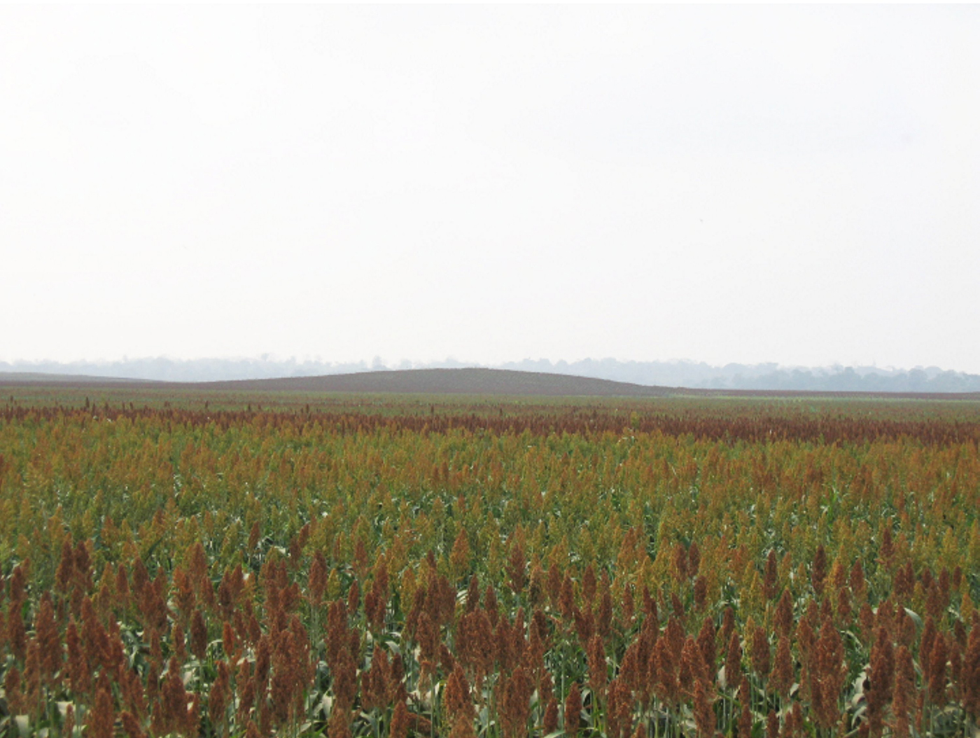
Deforestation and mechanized agriculture for sorghum production also have contributed to the drying of the northern plain and its sedimentation in relatively recent times. Regardless of these many alterations, the northern plain continues to attract local fishermen who observe that, when floodwaters recede, optimal conditions exist for the extraction of aquatic resources in significant quantities. This pattern seems to indicate that the northern plain is somewhat deeper than the surrounding floodplains and may have been even deeper during Olmec times.
Archaeological evidence for environmental fluctuations consists of flood damage to the low floodplain mounds and the structures and features that sat upon them. The stratigraphic sequence clearly indicates a period of initial mound construction, followed by sequences of water damage and mound reconstruction, suggesting that flooding increased with the passage of time (Cyphers et al. Reference Cyphers, Zurita Noguera and Rodríguez2013).
Further key evidence of environmental changes comes from botanical analysis such as phytolith studies conducted by Zurita Noguera (Reference Zurita Noguera and Cyphers1997). Her work focused on sediment samples taken during controlled, systematic excavations. The results show the presence of riparian vegetation of “popal” type, comprised primarily of palms (palma yagua, Scheelea liebmannii, and palma de coyol real, Acrocomia Mexicana; Cyphers et al. Reference Cyphers, Zurita Noguera and Rodríguez2013; Zurita Noguera Reference Zurita Noguera and Cyphers1997).
LiDAR ANALYSIS
This study seeks to better delineate the northern plain using LiDAR analysis, a method commonly used by archaeologists for site prospection. Sensors such as LiDAR or high-resolution photogrammetry images by means of Remotely Piloted Aircraft Systems allow the detailed study of landforms by providing altimetry data with high horizontal resolution as well as centimeter vertical accuracy (Ballarin et al. Reference Ballarin, Balleti, Guerra, Remondino and Shortis2015; Hämmerle et al. Reference Hämmerle, Schütt and Höfle2016). The advantage of using LiDAR resides in the fact that objects on the earth's surface are represented by X, Y, and Z coordinates and, depending on the type of scanner, a full waveform will be recorded. LiDAR is a technique of remote sensing that uses a laser mounted on different types of platforms (terrestrial, aerial, and satellite). The laser emits pulses in the near-infrared spectrum, and each pulse is reflected one or more times in the objects of the earth's surface. The position of the objects is calculated by the time difference between the emission of the pulse and each received return, the angle of the laser, and the position of the platform calculated by means of differential global position systems and the inertial measurement unit (Coluzzi et al. Reference Coluzzi, Lanorte and Lasaponara2010; Masini et al. Reference Masini, Coluzzi, Lasaponara and Wang2011; Renslow Reference Renslow2012). Returns correspond to the reflected pulse according to the morphology and distribution of the objects. Moreover, if a pulse reaches the ground directly, its return will represent this surface. The result of a basic LiDAR survey corresponds to the earth's surface representation with a point cloud. In archaeological terms, these cloud representations have allowed the identification of new human settlements in valleys and plains with dense vegetation (Doneus et al. Reference Doneus, Briese, Fera and Janner2008; Chase et al. Reference Chase, Chase, Weishampel, Drake, Shrestha, Slatton, Awe and Carter2011, Reference Chase, Chase, Awe, Weishampel, Iannone, Moyes, Yaeger and Brown2014; Golden et al. Reference Golden, Murtha, Cook, Shaffer, Schroder, Hermitt, Firpi and Scherer2016; Hutson Reference Hutson2015).
We base the present research on a LiDAR point cloud that has been used to generate the DTM of the archaeological region around San Lorenzo. In this section, we detail the ways in which our study has used LiDAR data: (1) to define the extent of the northern plain by comparing the archaeological limit proposed by Cyphers et al. (Reference Cyphers, Zurita Noguera and Rodríguez2013) and by using flood simulations to recreate different stages of the ancient water body; (2) to determine the ancient morphology of the plain by conducting a set of iterative interpolations that consider the perimeter and successive altitude values for the deepest points of the northern plain; and (3) to repeat the latter procedure until finding a correlation between the reconstructed surface of the plain and the depth of the mound foundations that was measured in the field.
Definition of the Extent of the Northern Plain
The first and primary step of this study is the delimitation of the northern plain with distinctive morphological criteria that show how it stands out from other nearby floodplains. Initial archaeological and ethnographic studies provide data that suggest that the floodplain exhibits important alterations north of the modern day ranch called Casa Blanca (17°44'46 N, 94°47'48.5 W). To test the observations about the terrain, we utilized the point cloud data from the LiDAR survey made available by Mexico's National Institute of Statistics and Geography (INEGI). This survey was conducted in 2009 following a zigzag pattern, with a maximum mean separation of 10.8 m/8.5 m and a density of 0.021 points/m2. Orthometric heights were corrected, filtered, and, finally, the selection of ground return was carried out to generate the DTM using a 5-m2 cell. The resulting DTM has 5-m resolution and the accuracy of the LiDAR-derived product is 0.30 m, corresponding to the tolerance stablished by the American Society of Photogrammetry and Remote Sensing (ASPRS) and proposed by Hodgson and Bresnahan (Reference Hodgson and Bresnahan2004).
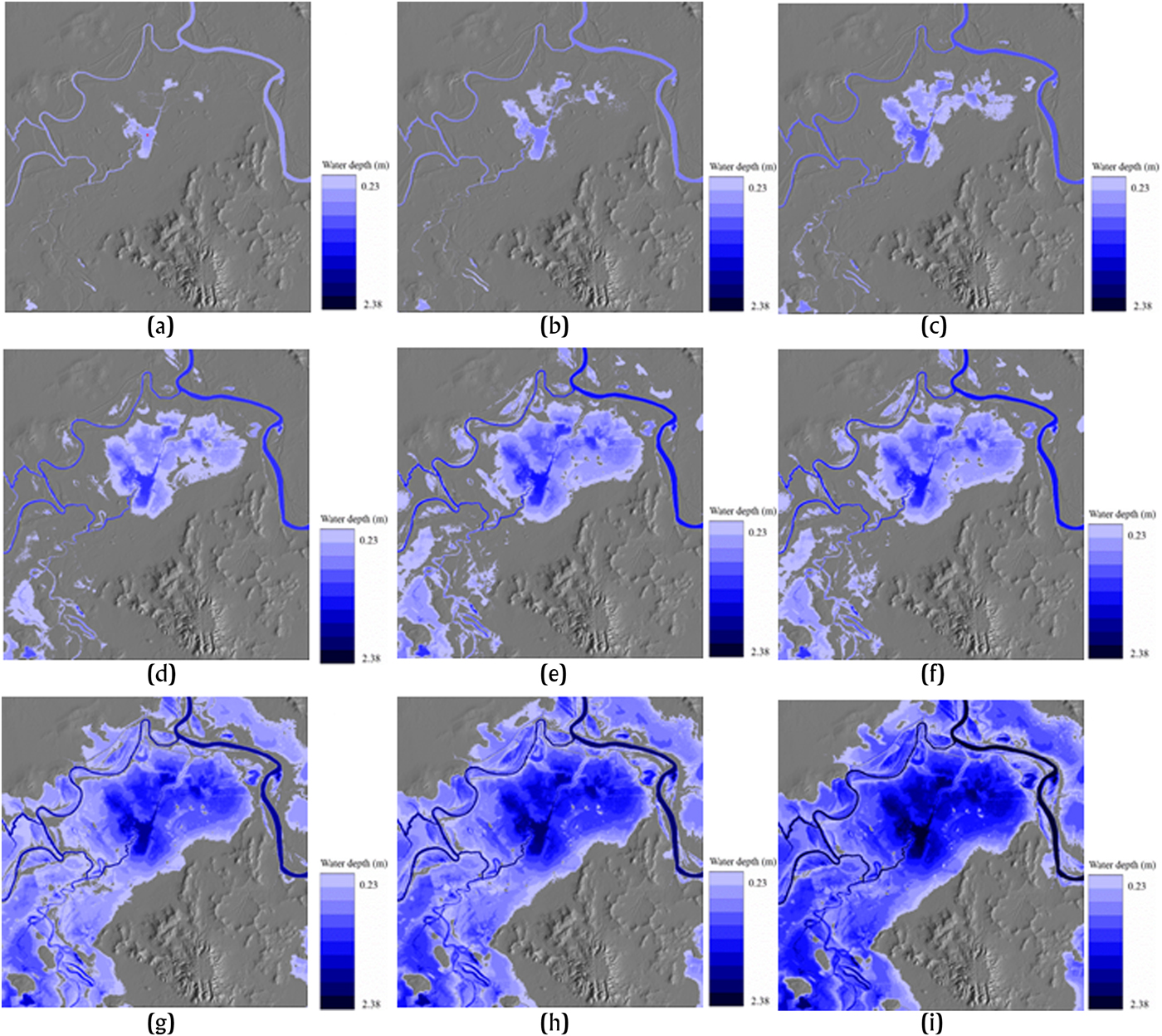
We obtained the initial extension of the northern plain by considering the minimum altitude of the study area (x, y, and z) or by providing the users’ defined coordinate (x and y) and an attributed altitude value (z’). This procedure (algorithm Terrace_explore, developed by Parrot and Ramírez-Núñez in 2016) allowed us to show the sequence of the floodwaters as they invade the terrain. It calculates the surface extent of the study area as it is progressively filled with water in 18-cm increments. The process stops only when the low mounds emerge from the inundated surface. We then compared this surface to the terrain defined as the northern plain by Cyphers et al. (Reference Cyphers, Zurita Noguera and Rodríguez2013) and used it as the area to recalculate the basal morphology.
The flood progression sequence (Figure 6) shows that the archaeological and ethnographic perceptions of the northern plain are correct. This area is indeed slightly lower in altitude than the contiguous upriver terrain and has an approximate basin-like shape. It covers an area of 859 hectares (8.59 km2) and a volume of 9 × 10⁶ m3 (0.009 km3). When the floodwaters penetrate 24 percent of the shallow basin, two-thirds of the Early Preclassic low mounds emerge above the surface of the water (Figure 6e). Therefore, we consider that the surface area of the flood in Figure 6e corresponds to the ancient extent of the northern plain. We binarized this surface for use as a masked area in the subsequent interpolation treatment.
Flood sequence obtained for the filling algorithm at the northern plain of San Lorenzo. The blue scale represents the area occupied in percentage/water layer height in meters: (a) 3.22 percent/1.9 m and red dot the local minimum altitude; (b) 4.87 percent/2.14 m; (c) 8.12 percent/2.38 m; (d) 15.13 percent/2.85 m; (e) 24.03 percent/3.33 m; (f) 48.71 percent/4.28 m; (g) 56.10 percent/4.76 m; (h) 58.9 percent/4.99 m; and (i) 61.24 percent/5.23 m. Image by the authors.

Defining the Ancient Altitude of the Northern Plain
We calculate the altitude of the plain as it was in Olmec times by using multi-directional interpolation. This interpolation requires using the masked area as the surface of the northern plain. The ancient basal morphology of this plain may be generated by using the perimeter of the mask and, inside the mask, a point corresponding to A s, the actual minimum altitude. Excepting this point, the treatment attributes a neutral value equal to −99999 to the mask while assigning a zero-altitude value to the perimeter of the mask and the outside area.
The interpolation method used in the present study is based on multi-directional interpolation, developed by Parrot in 1993. This algorithm is reported and described in software DEMONIO (Parrot Reference Parrot2012).
The altitude A p of each point p of the neutral zone is defined as follows:
 $$A_p = A_i + \lsqb {\lpar {A_S - A_i} \rpar \times \lpar {d_i/d} \rpar } \rsqb \eqno \lpar 1 \rpar $$
where d = d i + d s; d i corresponds to the smallest distance between the point p and the closest point of the mask's perimeter whose altitude is A i; and d s is the distance between the studied point p and the single point whose altitude value is A S.
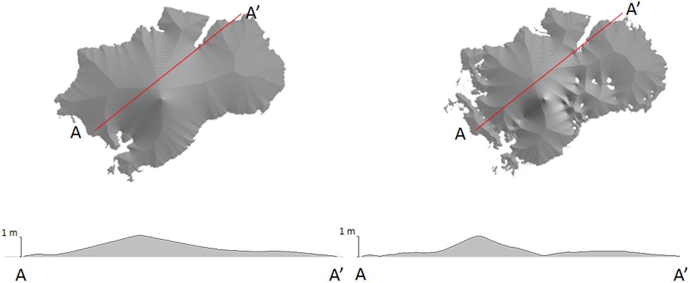
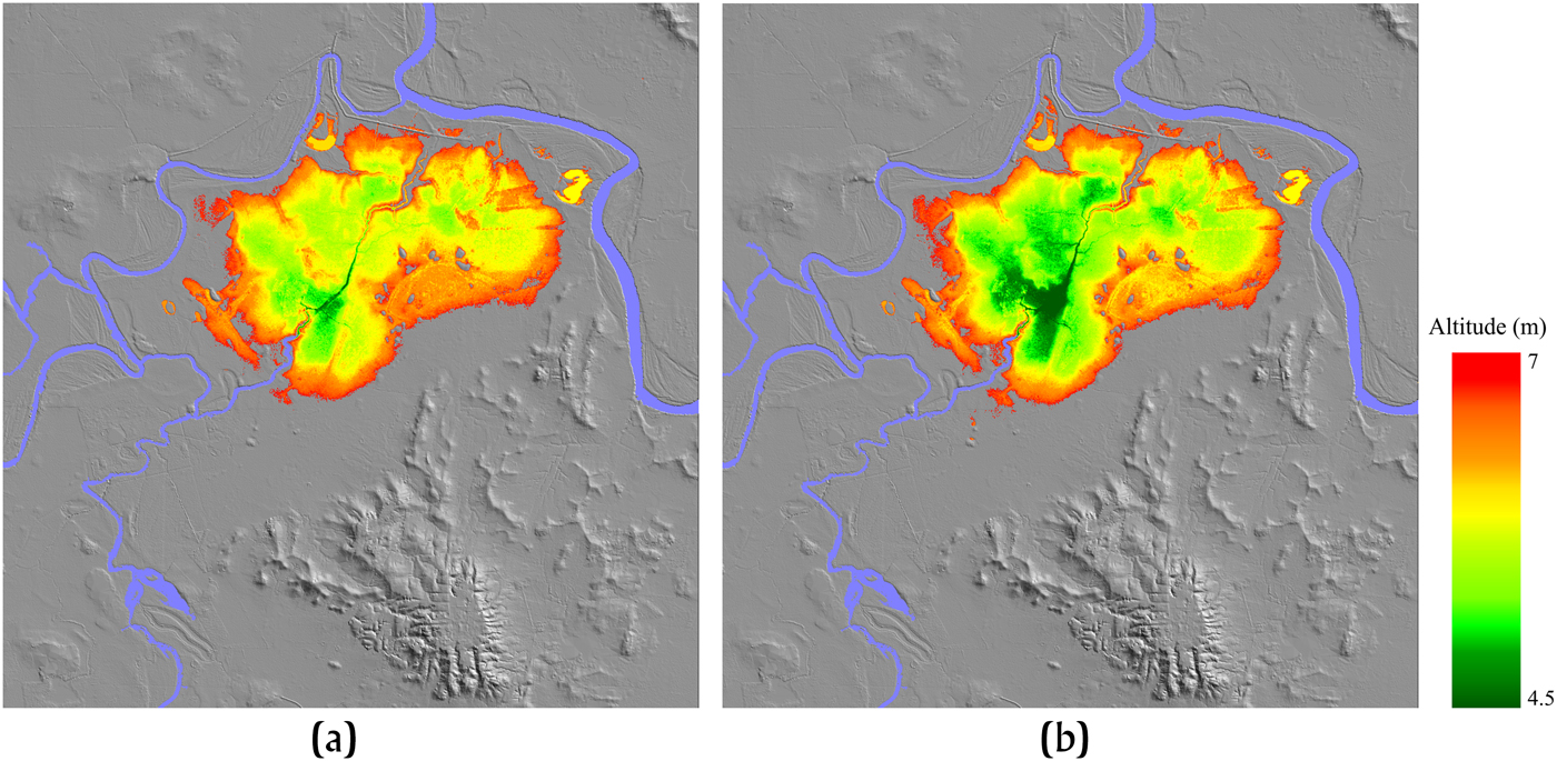
When analyzing the risk model and the flood plain mounds, we considered that two calculations would be significant, one without the mounds and the other with them. When the mounds are not considered in the calculation (Figure 7a), the result corresponds to the mean. When they are taken into account (Figure 7b), however, the elevation model generated by this method has a better fit with the thickness of the fluvial deposits. Then, this local digital elevation model is subtracted from the original DTM to provide a model (Figure 8) that allows us to calculate the water volume of the simulated basin.
Digital model of the fluvial deposits in the study area. The model on the left does not consider the mounds, whereas the one on the right takes them into account. Image by the authors.

(a) Original DTM of the northern plain. (b) Northern plain model produced by multi-directional interpolation. Image by the authors.

Defining the Lowest Minimum Altitude of the Ancient Northern Plain
Archaeological excavation data were used to determine the depth of the lowest point of the shallow basin (corresponding to A s in equation 1). This validation was obtained when the interpolated (or reconstituted) bottom of the basin corresponds to the thickness of the artificial fill of the floodplain mounds that were built by the Olmecs thousands of years ago upon the original surface of the natural basin.
Regional surface survey recorded 47 mounds in the northern plain (Symonds et al. Reference Symonds, Cyphers and Lunagómez2002), but subsequent mapping and analysis of LiDAR data (Cyphers et al. Reference Cyphers, Zurita Noguera and Rodríguez2013) suggests the presence of at least another 71 mounds. Thus, the minimum number of floodplain mounds in the northern plain would have been 118. We have precise cartographic information for 68 of these mounds. The data shows that their height ranges from 0.5 to 4.65 meters with an average height of 1.52 m.
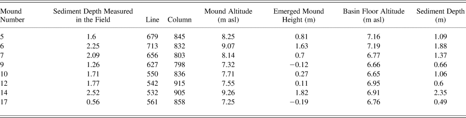
Excavations were conducted in 17 mounds, but not all test units reached sterile soil. The stratigraphic units dug in eight mounds (reported in Table 1) reached underlying non-cultural soils. The average height of these eight mounds is 1.72 m. The depth of cultural soils ranges from 1.4 to 4.6 meters, with an average of 2.57 m, giving us the maximum height of each mound in ancient times.
Descriptive data on eight excavated floodplain mounds used for model calibration that includes visible height, UTM coordinate location, the depth of sterile soil in centrally located test units, and the thickness of the sedimentation in the plain surrounding the mounds. It is important to note that the depth of sterile soil corresponds to the real altitude of the mound.

The current visible height of mounds is always lower than the height calculated from excavations due to the overburden of sediments concealing the original surface on which the mounds were built. In the sample of eight excavated mounds, the difference between the current height and the natural depth of the soil indicates the thickness of sedimentation after Olmec occupation (Figure 9). This thickness ranges from 0.19 to 2.35 meters, with an average of 0.93 m.
Comparison of the sediment depth calculation for 1.6 m at point A s. Graph by the authors.

The above values have been used to test the results provided by analyses based on a progressive increment of the maximum depth (A s). Using the results provided by interpolation analysis (program Deprim_miel.exe, developed by Parrot and Ramírez-Núñez in 2016), we developed another algorithm (program Coord_UTM_puntos.exe, created by Parrot and Ramírez-Núñez in 2017) to compare these new results with the values reported in Table 1. The latter program notes the original DTM and the thickness of the fluvial deposits. For different values of the point A s, it calculates the altitude of each mound surface, the lowest point of post-Olmec sedimentation layer, and the difference between these two values (Table 2). From these estimates, we are able to calculate the correlation between values measured in the field and values obtained by the models (Figure 10). Furthermore, we can gauge the standard deviation of the difference between sediment depth measured in the field and sediment depth provided by interpolation (last column of Table 2).
Evolution of the r2 value in relation to the maximum depth. Graph by the authors.

Results obtained by means of the program Coord_UTM_points.exe when comparing the eight floodplain mounds reported in Table 1.

The successive test values used to calculate and calibrate the depth of the northern plain range from 1 to 2.5 meters with a test calculation applied at each 0.1-m interval. This approach allowed us to estimate the maximum depth of the northern plain during the early Olmec occupation. One factor we considered was the evolution of successive standard deviation values (Figure 11). These were calculated from the difference between the sediment depth measured in the field and the sediment depth provided by the treatment. As observed in Figure 11, the lower standard deviation value confirms an optimal result. When considering the evolution of the r2 value, we estimate a maximum depth of 1.6 m.
Evolution of the standard deviation to maximum depth (2.4 m). Graph by the authors.

RESULTS
By combining the depth of the water level used to delimit the northern plain (7.44 m asl), the present minimum value of the altitude below the water's surface (4.25 m asl), and the calculated greatest thickness (1.6 m) of sedimentation after the Olmec occupation, we conclude that the basal altitude of the ancient basin was 2.65 m asl, with a maximum water depth of 4.79 m. At the present time, the base level is only 3.19 m asl.
Using the difference between the present and reconstructed DTMs, we calculate an area for the northern plain of 859 hectares and a volume of 9 × 10⁶ m3. Today's capacity has been reduced to a volume of 7.8 × 10⁶ m3.
Our models validate the interpretations based on field observations. Furthermore, when combined with algorithms, they confirm the archaeological interpretations. We affirm that the northern plain in Olmec times was deeper than it is today and thus would have been a source of abundant aquatic resources.
CONCLUSIONS
LiDAR is a technology that has transformed many aspects of archaeological research. It enables researchers to visualize landscapes in a way that was previously impossible, thereby revolutionizing the way they may be understood (Chase et al. Reference Chase, Chase, Chase, Masini and Soldovieri2017). This interdisciplinary study makes use of LiDAR data in a manner that goes beyond the basic identification of archaeological features. It illustrates the extraordinary potential of LiDAR surveys to contribute to a fuller understanding of human-environmental relationships through collaborative scientific research (see Golden et al. Reference Golden, Murtha, Cook, Shaffer, Schroder, Hermitt, Firpi and Scherer2016). It has allowed us to confirm the basin-like shape of the plain located immediately north of San Lorenzo using LiDAR analysis and archaeological excavation data. Early Olmec interest in food production in this terrain appears to be related to its ancient characteristics. The basin covers a considerable area, 4.2 × 3.7 km (Figure 12), and would have been suitable for sustaining a permanent wetland with popal vegetation. As compared to narrower floodplains, the reduced gradient, abundance of ramified fluvial courses, greater depth, and water capture would have contributed to a significant concentration of aquatic resources in this area. A greater biomass of invertebrates, birds, and fish is also generally associated with deeper water and wider floodplains (Power et al. Reference Power, Gary, Dietrich and Sun1979).
Relief map of San Lorenzo and the northern plain as defined by the LiDAR analysis. Image by the authors.

The cost of resource procurement is equally as important as its abundance (Limp and Reidhead Reference Limp and Reidhead1979:71). An unequal distribution of morphological features such as branching and migrating river courses, point bars, alluvial fans, swamps, decantation basins, and levees of extinct and active river courses (Ortiz and Cyphers Reference Ortiz, Cyphers and Cyphers1997) condition differences in resource availability. So do variations in hydrological and climatic cycles. Geomorphic elements such as oxbow lakes, decantation basins, and lateral channels facilitate the use of efficient techniques for harvesting aquatic resources (see Coe and Diehl Reference Coe and Diehl1980; Limp and Reidhead Reference Limp and Reidhead1979; Ortiz and Cyphers Reference Ortiz, Cyphers and Cyphers1997). The study of modern fishing practices reveals that floodwater recession in the northern plain leaves fish trapped in residual lakes and basins, thereby expediting their large-scale capture.
The seasonal base camps established on the low mounds in the wetlands of the northern plain provided safe haven for the people who were involved in the large-scale capture of aquatic resources. The mounds also represented strategically located venues for the processing (smoking) of these resources with palm fuel easily obtainable in these same wetlands. Furthermore, the mounds provided possible periodic production locales for storable supplies needed in crisis times. As population grew over time, competition for aquatic resources also increased. The mounds established in the northern plain by San Lorenzo's founding groups and their descendants would have provided permanent access to a highly productive resource area, the products of which were important for subsistence security during times of crisis.
Sadly, the wetlands of the northern plain once enjoyed by the Olmecs are rapidly vanishing. Our LiDAR analysis shows that the thickest deposit of sediments in this terrain is 1.6 m. This deposit is caused by the original basin shape and the coincident action of various processes such as deforestation, uplift, river course migration, and mechanized agriculture over the course of the last three millennia. Illicit looting and intensified exploitation have contributed to the gradual or sudden disappearance of the low mounds, once unique hotspots of intensive wetland food production that played a key role in the development of complex society at San Lorenzo.
RESUMEN
Desde sus comienzos hace unos 4000 años, hasta su decadencia alrededor de 400 a.C., los olmecas alcanzaron un alto nivel de complejidad sociopolítica y dominaron su territorio en la costa sur del Golfo de México. La primera capital olmeca, San Lorenzo, Veracruz, fue, entre 1800 y 1000 a.C., el único sitio en Mesoamérica que produjo una imponente escultura de piedra y arquitectura monumental entre 1800 y 1000 a.C. Estas características reflejan las capacidades de su sistema político centralizado encabezado por gobernantes hereditarios con legitimación divina, lo que fue clave para el desarrollo, subsistencia y medio ambiente del centro olmeca de San Lorenzo. El presente estudio se centra en una parte del paisaje ubicado inmediatamente al norte de la primera capital olmeca de San Lorenzo, Veracruz, que se ha propuesto como un área clave de recursos durante el desarrollo de la primera civilización en Mesoamérica. Calculamos la superficie, el volumen y la profundidad del agua de esta área con base en los datos arqueológicos y un Modelo Digital del Terreno (DTM) derivado de un vuelo LiDAR aerotransportado. Su área mínima y máxima esperada, la altitud mínima local y el DTM de 5 m de resolución espacial proporcionan una base para las inferencias sobre las características del ecosistema de los humedales durante los tiempos de los olmecas. El objetivo es cuantificar y estimar el potencial en recursos de esta zona basándose en la topografía LiDAR. Nuestros modelos validan las observaciones en el campo y, cuando se combinan con algoritmos, confirman las conclusiones arqueológicas. Entonces, afirmamos que, la llanura al norte en la época olmeca era más profunda de lo que hoy es y que pudo ser una fuente de abundantes recursos acuáticos para la subsistencia primaria de la temprana sociedad olmeca.
ACKNOWLEDGMENTS
This research was funded by CONACYT (National Science and Technology Council of Mexico); Software License and research facilities were provided by the LiDAR Research Group (GIScience Department, Institute of Geography, Heidelberg University) headed by Dr. Bernhard Höfle. We also would like to thank the anonymous reviewers for their helpful comments.