

The parish of Skee lies in the coastal region of western Bohuslän (fig 1), an area studded with ancient rock carvings. To the south of the small town of Skee itself, some 20km away, is Tanumshede and its adjoining area of World Heritage status rock art; from here the expanse of carving sites extends 40km or more southwards. To the north of Skee are to be found the abundant art sites of HogdalFootnote 1 and beyond the Idefjord political boundary are the well-known sites of Østfold. Skee thus lies amidst a lengthy south–north spread of rock carvings, the whole deserving of international recognition and status.Footnote 2
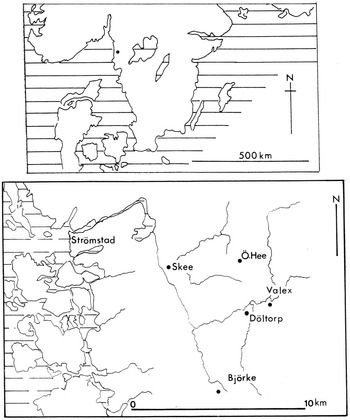
Top: map of southern Scandinavia with the Skee area marked. Base: map of part of western Bohuslän with the towns of Strömstad and Skee marked, as well as four rock-carving sites and major waterways. Drawing: author

The parish itself contains a large number of rock-carving sites, with several concentrations, including a well-known group at Jörlov, to the north of the site to be explored in this paper. Also present in the general landscape are numerous cairns and some barrows and stone settings; various scatters of stone implements, and the debris therefrom, are also known. Fieldwork in the region has not been as intensive as that for areas farther south, although there are exceptions to this in the early mapping of identifiable burial monuments and stone settings, the latter quite often subject to stone removal or dislocation, the former often in part dismantled in the search for treasure, if not for idle curiosity. There can be little doubt that more sites remain to be identified amidst the granite ridges and forested areas of the region, especially the smaller cairns and stone settings, which have often been disturbed or dismantled, so that only a few stones may remain in place. The same applies to rock carvings, with likely surfaces still covered by grass, lichen, moss, woodland debris and stones cleared from arable fields.
In 1992, during an intensive search for carved surfaces in parts of Skee parish, three new sites were discovered (numbered 1537, 1538 and 1539 in the national archive system) in the small catchment of land at Döltorp, about 10km to the south east of Strömstad (fig 1).Footnote 3 One of them (1538) consisted of cupmarks only, while another (1537) had a small number of images of boats, animals, discs and cupmarks, and the third (1539, the principal subject of this paper) displayed a great variety of carvings. S-G Broström and K Ihrestam, who found the three sites, reported their discovery by means of an informal photograph, recording the images by using chalk to highlight the carved lines.Footnote 4 A line-drawn plan of the whole site created a good deal of interest by virtue of certain images on the rock, and to some extent by their presentation on the printed page: a large boat with graceful human figures aboard, schematic horses, discs and axe-wielding warriors. Further valuable comment about the site was made by L Bengtsson in Reference Bengtsson1995,Footnote 5 suggesting the site cast new insights into both political and religious aspects of the later Bronze Age in the region; the original plan thus publicized has since appeared in other assessments. One of the principal reasons for such interest was the extreme delicacy of the carved lines making up the various images, and comments have referred specifically to the gracefulness and precision of the carvings on the granite surface at Skee 1539. As we shall see, such descriptive opinion is somewhat excessive, notwithstanding the fine craftsmanship exhibited on the rock.
In assembling records of sites for a general book on the rock carvings of Bohuslän and Østfold, the Skee site was an obvious inclusion and the published plan formed the basis for its presentation in that book.Footnote 6 My own site visits to Skee 1539 began in 2003, and new plans of the entire site were created by further fieldwork in 2004, 2005, 2007, 2008, 2009 and 2010. In all, eight visits were made, with various colleagues, and more and more details emerged through inspections under a variety of conditions (figs 2 and 3): dry and wet surfaces, early and late sunlight and frost. Rubbings were made of the entire site and repeated where necessary to elucidate details and problem areas where the rock surface was particularly rough and uneven. The fieldwork was also intended to explore why the carvings had been created in this location and how they related to other landscape features and prehistoric sites in the immediate area. That is the major theme of this paper – the site and its particular landscape setting – rather than the image analysis, comparanda and interpretive exercises that are the regular components of papers on north European rock art.Footnote 7
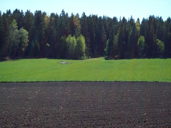
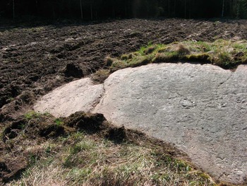
The Döltorp site (Skee 1539): a small rock within a large arable field (April 2008). Photograph: author

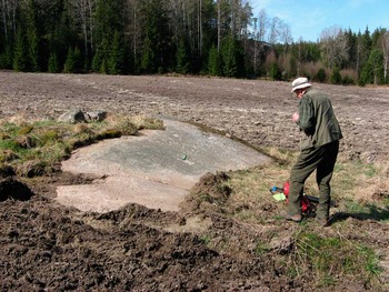
The Döltorp rock-carving site from the north north east (May 2009). Photograph: B J Coles

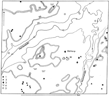
It is a particular feature of many rock-carving sites in Bohuslän that they once lay near the ancient coastal zone, and many sites were within both sight and sound of their contemporary sea.Footnote 8 In the centuries from c 1000 bc, the landmass of the region lay c 20m to c 13m lower than today; the isostatic recovery of the land was slow and uneven, and is still under way. Skee site 1539 lies well inland – about 8km from the present coast – and its height above today's sea level, at about 32–33m, suggests that it was not close to its seashore. Instead, it lies near the junction of two major streams (fig 4): the Vättlandsån, which today flows westwards at about 20–22m above sea level just to the west and north of the site, and the Hammensån, which flows northwards at about 28m above sea level to the south east of the site.
Map of the Döltorp area with two streams (Vättlandsån and Hammensån) and contours at 25m, 50m and 75m above sea level. The major site (Skee 1539) is labelled Döltorp. Key: 1. cairn; 2. stone settings; 3. rock carvings; 4. stone-flake scatter; 5. barrow. Drawing: author

The intimate landscape
The area of Skee parish within which site 1539 exists is an undulating landscape of low hills and ridges, quite densely wooded with many streams, both large and small, with large areas unoccupied and inaccessible by anything other than purposeful walking. Exploratory fieldwork, in search of sites and other landscape features, is difficult but often rewarding.Footnote 9 The basic rock is porphyritic granite, a coarse-grained acidic igneous rock of mottled colours and with visible and significant veins of quartz, feldspar and coloured minerals, usually mica.Footnote 10 The site itself lies as an unimpressive shallow outcrop of rock, mottled grey-brown overall, and speckled by whitish-grey-black tones, with a very rough surface and many cracks, crevices and an unevenness that at first glance obscures all and suggests that there are no humanly made marks upon the rock (fig 5). Such conditions partly explain why the site was only discovered in recent years, and parts of the carved surface were also obscured by soil until very recently; a scatter of field clearance boulders lies just above the outcrop (fig 3).
The granite surface of Döltorp, which is covered by rock carvings, barely any of which are visible, other than a deeply carved disc and part of a large boat hull (April 2008). Photograph: author

Before embarking upon a description of the site and its surroundings, it is worth making explicit some of the constraints that are involved in recording rock art – constraints that mean that a complete, unbiased and wholly accurate record can never be created. The recording of carved lines on a surface such as this site possesses, whether by touch and chalk (as done for the initial record of this site) or by rubbings of the entire surface (as done for this report: fig 6), will reveal shapes and the overall structure of a panel of carvings; but uncertainties and ambiguities will remain, even where an effort is made to make records in oblique light, under different weather conditions, when the surface is dry or damp and using different technical methodologies (not to mention experience and intuition). In addition to such difficulties, the overall plan of a panel or entire site can pose problems of structure, due in great measure to the shape of the surface of the rock itself, curving across the site and perhaps curving down towards the base, with internal variations here and there. To create an entirely horizontal plan of such a complexity without distortion of, for example, the distance between the images is difficult, if not impossible.Footnote 11 The site at Skee 1539 presents a wide variation of surface character, with some areas smooth and relatively even and others irregular and interrupted by quartz intrusions, and these features certainly influenced the position of the images on the surface.
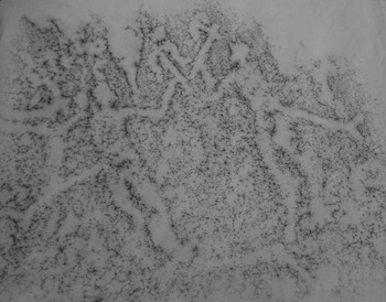
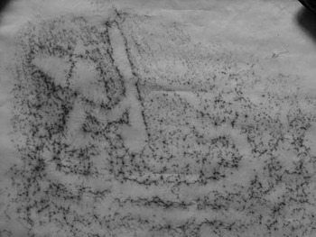
Rubbing of two axe-wielding humans, with scabbards for swords and a probable division between the tunic and the lower garment. The balancing arms are thin and barely finished in the carving. There is a tripartite stratigraphy at the left: small boat over large warrior over small warrior. Rubbing: author

Unlike many of the major rock-carving sites of Bohuslän, the position of Skee 1539 is not at all imposing. The rock upon which the carvings lie is low in its present-day arable field, is shallow in its slope and even today is occasionally partly covered by earth and manure cast up by farm machinery. The exposed surface (excluding the boulder-covered segment) is only some 4m wide and 2m high; it slopes at a modest 10–15 degrees down to the north east, more steeply at the base, and though it stands out more when surrounded by ploughland (figs 2 and 3), it is barely visible from a distance when the field is under crop. In the past, when the dense woodland that now curves around the site was absent, the small rock would be barely apparent to the passer-by, whose eye is more likely to be caught by the adjacent dramatic ridges of rock. During any episode when the whole area, including the current arable land, was wooded, this small and seemingly insignificant rock was probably invisible. Neither would the rough surface of the rock and its shallowly carved lines and images attract attention; only a carved disc near the base, and part of the keel line of a major boat, emerge from the briefest of inspections (fig 5). In low or awkward light, the images on the rock are, in essence, invisible.
The site lies at the western edge of a wide expanse of flat land (fig 4). Behind it, to the west and south, are powerful and abrupt granite ridges (fig 7). Wide views can be obtained here and there from the near-vertical rock faces across to the low rock of the site and beyond, over the flat land. The southern ridge is marked by several higher outcrops of rock, a stone setting in near-total disarray and, leading downwards to the east, lower ridges with traces of ancient monuments (noted below). The major and massive ridge to the west of the site (fig 8) spreads and rises to a height of 90m or so; the remnants of an enormous cairn lie at the top (also discussed below). From here, the descent towards the carving site and the flat land is uneven, in step-like ridges, with occasional boulders protruding through the thin soils and sparse vegetation; near the base, a more gentle slope holds several ancient streambeds, at least one of which is reasonably active with rain and spring waters. Lying in the middle of one of these, in a particularly wide streambed and about 130m from the carving site, is a huge isolated boulder (fig 9), with a group of shallow cupmarks on its upper surface; so far as we know, these have not been previously recognized.
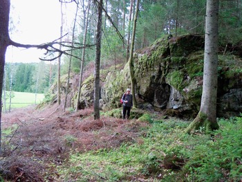
The southern ridge, about 40m from the carving site (August 2010). Photograph: B J Coles

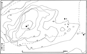
The Döltorp ridge, with the Röseberget at the very top, and steep ridge sides to north and west. Key: 1. cairn (C) = Röseberget; 2. stone setting; 3. rock carving (A) = 1539; (B) = 1537; 4. stone-flake scatter; (D) cupmarked boulder at exit from ridge onto lowland; (E) coloured stone at exit from southern ridge onto the lowland. The open squares are buildings; the dashed lines are modern roads and tracks. Drawing: author

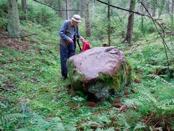
A large, water-worn boulder, lying alone in a wide streambed downslope from the cairn and near the western entry onto the lowland, about 130m from the carving. Cupmarks lie on the upper surface of the boulder (August 2010). Photograph: B J Coles

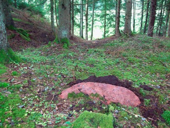
Along the steep southern ridge that provides an edge to the lowland approach and the site itself is another natural gap in the dominant rocky face, leading down onto the lower land; such an entry would provide a close access to the site, and it may be relevant to note that, at just such a point, there lies a large reddish granite boulder, perhaps deliberately placed here to mark a logical and easy access off the ridge onto the lowland and its carving site (fig 10). Just such reddish-coloured boulders are to be seen amidst the tumbled stones of the cairn high on the top of the ridge to the west; perhaps the low-lying boulder near the carving site was placed here en route to the cairn during the building of the huge burial monument, or perhaps the stone was originally a part of the cairn and was, a little later in time, brought down to act as a marker to the carving site while providing a link with the burial cairn high to the west.
A reddish granite boulder lying at the natural southern entry off the ridge onto the lowland, with the carving site behind the rising rock on the left (August 2010). Photograph: author

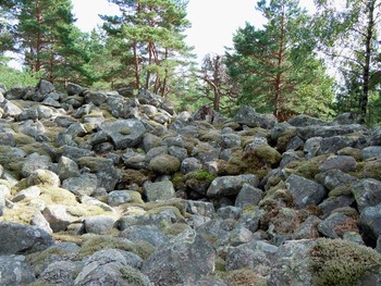
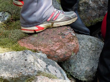
Rather little is known about this cairn, the Röseberget (fig 11). It stands at the moment about 4–5m high, upon the highest point of the entire ridge, and it may once have been 25m or so wide. The height of the ridge top and the cairn is magnified by the abrupt and steep sides of the ridge immediately to the north, north west and south, with access in effect limited to the east, leading down to the lowland with its carving site. The cairn has been partially dismantled: its central and primary large stone cist has been exposed by stone removal, which has also had the effect of expanding the cairn's diameter. No record exists of what, if anything, was recovered from such an action.Footnote 12 The stones used to form the monument are large (30–40cm in diameter) and heavy; they are roughly rounded in the main, and their combined weight probably lies around 180–260 tonnes. Their transport to this highest peak must have been a tremendous task in the earlier Bronze Age, perhaps 300–400 years before the lowland rock received its first carvings. It is the reddish boulder far below and at the ridge exit, allowing access to the rock-carving site, and the cairn's own complement of similar coloured stones (fig 12), that just provide an intriguing link between the cairn and the immediate area of the carving site.
The Röseberget (Skee 460) lies about 90m above sea level, high to the west of the rock-carving site. It has been partially dismantled by the removal of stones from the centre and the slabs from a presumed cist-like structure are visible in the central foreground (August 2010). Photograph: B J Coles

One of the reddish boulders in the Röseberget, high on the ridge at Döltorp (2010). Photograph: B J Coles

Monuments like this cairn are often considered to have marked territorial boundaries.Footnote 13 Others see them as forming significant focal points entirely within a particular landscape controlled or otherwise occupied by a social group. The selection of a specially prominent hill or ridge-top, as here at Döltorp, for a burial monument may have been intended to house and remember a dominant individual or a social or political group and to link their identity with an important landscape feature within the territorial eyesight of surrounding communities. The lack of any information about the Döltorp cairn's original content, apart from the remnants of a large cist-like structure at the base of the centre, is unfortunate; its specific chronology is thereby unknown, other than a general estimate of c 1500–1300 bc. Almost all of the cairns in the wider region around Skee 1539 also lie high in the landscape of ridges, at heights of 70m up to about 90m.
The more widely distributed stone settings in the Döltorp catchment are more varied in position on the heights, many at 60–70m, a few much lower, and the surviving stones of recorded stone settings, undated, in the immediate area of the Döltorp site are at the 35–50m level. Monuments like these are more varied in date: some of the later second or early first millennium bc, others probably later in age, while it is possible that the low-lying and now ruinous setting on the ridge just to the south of the rock-carving site was contemporary with the carvings, in the mid-first millennium bc.
Although the carving site itself is small, its position within the landscape of rocky ridges and streams is a powerful one (figs 4 and 8). Its images were carved to be viewed from the east, and its shallow sloping surface needs the viewer to approach closely (fig 3). In this last respect, the site is unlike many other major carving sites with steeper-sloping surfaces adorned with images that can be seen from afar, and where the details are progressively revealed as the viewer approaches. At this site, the images are only and always visible with difficulty (fig 5), and only by a direct and close contact with the viewer. It may be that the large, steeper-sloping rock-carving sites of Bohuslän were selected to be easily visible to approaching groups of people, advertising the presence of such a major monument. Many smaller sites are more obscurely placed, low and shallow, and hence perhaps only known to and visited by entirely local people – the members of a family, perhaps.
At the time of carving, and shortly thereafter, the images at the Döltorp site would be clear, as the untouched granite surfaces would contrast with the carved lines, but such clarity would last for only a short period (perhaps ten years or so); gradually the rock would assume a uniformity of obscurity, unless retouched or coloured on particular occasions.
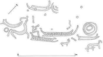
Site 1539 lies isolated, to an extent, within its own special landscape. Facing eastwards, there is no apparent or prominent landmark or other monument to mark its presence. The adjacent low ridges are mostly barren of other ancient and near-contemporary monuments, other than the stone setting on the ridge immediately to the south, consisting today mostly of a scatter of rocks. To the east, on narrow and low ridges, are some cupmarks (Skee 1538) and slightly to the south of these is a small, figurative carving site (1537) (fig 13). Its imagery appears upon a steeply sloping surface (17 degrees); the rock is not very smooth and green lichen has obscured the carvings since their exposure by soil removal in 1993.Footnote 14 This site appears to be a near-contemporary of Skee 1539 in imagery and style. Much farther afield, to the south west, are cairns and stone settings.
Skee 1537 rock carving with carving depths as for Skee 1539. Based on boat styles, the two carving sites appear to be broadly contemporary. Drawing: author

To the east, the confluence of the streams provided a wide expanse of lowland and a logical and persuasive approach, upslope, towards the major site itself. The presence of the huge cairn (Skee 460, the Röseberget) to the west of the carved site, steeply upslope and immensely dominant in its overview of the entire lowland across to the Hammensån, must have had a role to play in the choice of the tiny outcrop, far below, for the carved representations of images that were perhaps traditional and powerful for the people occupying this region. The few known scatters of stone-tool debris, perhaps marking small-scale occupation along the lower ground to the south, might have had a part in such linked activity (fig 4).
Notwithstanding such a hypothetical link to the western heights, there can be little doubt that the site itself, Skee 1539, was to be viewed from the east, and at close range. A small and shallow rock, with images tightly packed together and a rough surface, would demand an audience confined perhaps to ten or twelve participants, standing just at the base of the exposed surface, and the evening or otherwise low sun slanting down the rock. What was said, indicated, felt and taken from such a visit and such a view is mostly beyond our understanding at the moment. But a closer look now at the imagery may encourage some ideas.
A theatre of imagery
The site itself is hardly an impressive document when viewed as we approach it across the gently rising land, or come directly to the rock from the boulder-marked passage off the ridge on the south. Yet its position, at the very edge of the higher landmass to the south and west, suggests its selection by the society concerned as a stage, a theatre, to be approached with care and to demand attention and close proximity in order to observe, comprehend and appreciate the linkages and individual artistic achievements displayed upon the rock (fig 14).
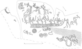
The Döltorp rock carving, Skee 1539. The rock slopes down to the north east at 9 degrees, upper left; 17 degrees, upper right; 19 degrees, lower left; and 25 degrees, lower right. At the south-eastern end of the rock, the slope is to the south east at 5–10 degrees. The depth of the carved lines varies, and the dark shading represents deeper carvings. An area of granite with dense intrusion of quartz, with feldspar and mica, is marked at the lower right. Plan: created 2008–10; © John Coles

The plan of Skee 1539 presented here represents, reasonably accurately, the shape of the site, the number and variety of its images, their associations and the degree of carving conviction and a measure of their time-frame. In comparison with the published plan, this new plan changes the shape of fifteen to twenty carved images, and records for the first time about ten carvings, including boat, cupmark, disc and human images; numerous minor adjustments are also made. All of this should not diminish the importance of the original work of recording on the site. They do, however, serve to clarify a site composition that is not quite as refined and with such minuscule line-widths as originally depicted. They also suggest that the site had a longer history than originally proposed. It should be noted here that only the major fissures on the rock surface are shown on the plan, and the many small natural cracks are omitted; a glance at the character of the surface (fig 5) will give an idea of the number and character of such cracks.
The entire panel of carvings is dominated by the large boat, about 2m in length, with tightly curved fore and aft stems and intricately decorated hull, occupied by six uniformly structured humans with upheld stakes, spears or torches; the seventh figure at the fore stem crouches low and there is no space for a stake. The large human figure touching the prow is likely to have been carved with that contact in mind. The boat is quite exceptional in its length and, above all, in its hull adornment; the design chosen for the hull is human-like at initial glance, not entirely so upon inspection, yet lively and enticing to the viewer. The design is complex and the granite unreceptive to such detail; there is damage at places along the hull and only traces of the overall theme survive. Nonetheless, the design appears to extend along the entire hull. It is noticeable, and unusual, to see the hull shape diminish in height as it extends along the rock; this was probably necessitated by the condition and character of the surface itself, which deteriorates in quality amidships, and is particularly bad just beneath the keel as it extends forward (fig 5).
The boat is very reminiscent of the large craft at Kasen Lövåsen, in Tanum parish, which has comparable shapes of fore and aft stem (although the aft stabilizer at Lövåsen is more pronounced),Footnote 15 while the bent-over crew with torches or spears at Lövåsen are dominated by a large figure at the stern, rather than being controlled by a comparably large figure at the prow, as at the Döltorp boat. Other very large boats at Post Hornes in Østfold have the same general arrangement of curvature and stem extension, although no major identifiable human figures are depicted.Footnote 16 Comparable boat-carving images can be seen in many other parts of Bohuslän, and the particularly large craft thus delineated often have human figures as crew, rather than mere strokes.Footnote 17 On such boat images, the keel line is often extended to create an aft stabilizer and, forward, curves upward to an extended prow. The gunwale line tends to turn rather abruptly upwards to form elaborately headed fore stem and aft stem, and their particular style helps to date such boats, within phases of the second or first millennium bc.
The largest boats, approaching 1.5–2m in length, have the logical effect of dominating the entire panel of images, although some of these boats are positioned at, or near, the base or the edge of a panel. Not so here at Döltorp, where the boat overwhelms all else on the small rock; the viewer of this site has to peer carefully above the boat to make out the detailed images of humans, in particular. Carvings may well have been made on the site at the eastern edge before the big boat was created, but it is likely that the main surface was mostly clear of imagery before the decision was taken to make such a large representation, occupying almost all of the width of the suitable surface.Footnote 18 A majority of boat designs such as this appear to belong to the early to middle first millennium bc, based upon typological relationships with ‘Ships on Bronzes’,Footnote 19 where numerous metal objects from dated contexts of the Bronze Age contain miniature images of boats. On this basis it is likely that this boat and its occupants were carved around 900–700 bc.
As has already been noted, the surface of the rock was very irregular, but such a condition might have more than one explanation. The natural granite surface may have eroded to its present condition since the carvings were made, though this seems unlikely, granted the character of the intersections between the natural cracks and the carved lines. It is more likely that the surface was pitted and irregular before it was selected as a canvas for the imagery. Just as importantly, the site itself was thereafter probably covered, and thus protected, by soil formation and vegetation from a time subsequent to its use as a carving surface until very recent years. This has acted to preserve a fragile surface with relatively shallow carvings. It is entirely possible that the panel was deliberately covered once its images were no longer considered to be appropriate to the society of the time; a simple scattering of soil or loose rocks would successfully have masked the site.
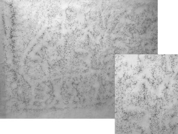
A majority of the well-known carving sites in western Bohuslän and elsewhere have been exposed and subject to water, frost, sun, human presence and recording techniques for many years, and their surfaces may well have suffered and been smoothed by these combinations. Here at the Döltorp site, the surface has seen very little erosion; hence it has retained much of its original character, poor as this may seem. One benefit of such a state is that the carvings may well have retained idiosyncratic features, errors and misjudgements on the part of the artists, and delicate attempts to show details that did not work or survive elsewhere. This has led to the possible identification of unanticipated image details. For example, one of the boat's occupants appears to have a detailed face, with hair, forehead, eye, nose and beard (fig 15), due in part to a convenient array of minor irregularities in the rock surface – perhaps accidental, but perhaps utilized and enhanced by the carver. That same roughness makes the recording of the marks all the more difficult, so the record does not show all the detail of the carvings. Of those crew heads reasonably well preserved on the rock surface, three seem to have traces of facial features, though this is only a suggestion, offered as nothing more than an intriguing thought.
Rubbing of the boat keel area, with decorated hull and the human figures on board; the rough-surfaced granite tends to inhibit carving precision but here the artist has managed to create quite dynamic images. The inset shows one of the human figures, who appears to have an individualized face. Rubbing: author

Mention has been made of the gradual thinning of the boat hull in its fore section. We might well think that the artist carver, in setting out his or her image plan, would have allotted sufficient space on the rock for the execution of the design. It could be, of course, that the diminution in the boat's fore section was a deliberate act, to show or suggest a ‘travelling away’ of the craft; even the crew are smaller towards the bow than at the stern section. The image as it stands does provide an impression of movement, of liveliness, and we would hesitate to suggest that the carver had made an error in the development of the image. That the craft avoids the very poor surface beneath the keel is clear, and it also avoids the serious crack above the boat, as the whole available surface was narrowed. Another element constraining the design may have been the pre-existences of the warrior figures above and the large disc below, and these would certainly have restricted the space available for the desired boat image. It is possible, too, that the area of quartz and other irregularities in the rock surface was a part of the design and structure of the imagery, so the boat would appear to be rising upwards, cresting a wave.
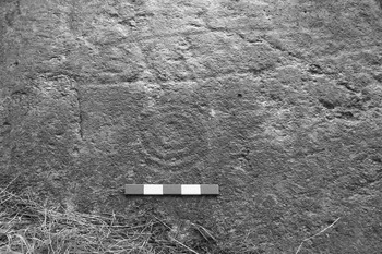
Below the boat are a number of discs. One is large and rather deeply carved, with two inner circles and a cupmark (fig 16), while another disc has an internal spiral line. There are three smaller discs beside the horse images, and two of them have internal cupmarks. All of these discs lie at the base of the site and are not intimately associated with any other carving. Discs like these are linked with boat carvings on a number of other sites and a recent study has suggested that they represent the sun and its journey across the skies in south Scandinavia; the debate includes reference to associations of sun discs with boats and with horses, and suggests origins of the sun journey in Indo-European mythology.Footnote 20
The deeply carved disc with inner rings and central cupmark, below part of the hull of the major boat image (scale 25cm). Photograph: author

Well above the major boat is a pair of finely detailed humans, with axes held high, sword scabbards in place, and in confrontational attitude (fig 6). They may be standing near or upon a thin boat-line that merges with one of the strokes of an earlier boat, but the intersection is unclear. The character of the two warriors, and their position, suggest that they were created at a slightly different time from that of the large boat, and are perhaps contemporary with the multi-ringed disc noted above; the craftsmanship in the carving of the warriors and the disc is similar, and different from that seen on the large boat, spirals and horses. The warrior figures and the large disc were created upon rock surfaces that appear to be the most solid and smooth available on the whole site, apart from a small area on the south east which probably had earlier images already in place.
Behind one of the warrior figures is a small image of a human holding a torch or stake, crouched upon a small boat or sledge, with a large, perhaps hooded, head and a trailing bundle of hair or other material just behind the head (fig 17). This overlies the arm of one of the warriors and is deeply carved, as are the adjacent small animal and the upside-down boat.
Rubbing of a small human aboard a boat or sledge and carrying a club or oar. The head seems to be hooded and the shape behind this, though of unknown identity, helps give the image a dynamic element. Rubbing: author

The pair of warriors is particularly intriguing. Clearly shown are their two crescentic-bladed axeheads, and these are reminiscent of bronze and clay-based axeheads from Danish contexts generally dated to the late second millennium bc.Footnote 21 However, the warrior figures are wearing sword scabbards with bifurcated terminals, and these occur on many rock-carving sites generally dated to the period c 900–600 bc. There is also a relationship between such scabbard designs and images of shields on some sites.Footnote 22 The representation of crescentic axes is not so often clearly set out and they are generally associated on the rocks with images of the same first millennium bc period.Footnote 23 Although it is likely that the warrior figures are broadly contemporary with the major boat design in the rather coarse cultural terms we use, the evidence of surface quality, carving character, boat positioning and hull constriction all suggest the warriors and the disc were not carved at the same time as the dominant boat, but slightly earlier.
The character of the horses and the spiral designs would appear to belong to a period within the mid-first millennium bc, c 700–500 bc or slightly later. The horses, all of them placed on the north and west of the panel, are stylized, with detached or otherwise exaggerated tails. Their representation is very schematic; they are almost as stylized as the duck-like creatures on a site at Tegneby in Tanum,Footnote 24 or the acrobatic humans at Askum.Footnote 25 It is curious to note that, although the granite surface of the entire panel is rough and uninviting, it is particularly so over the northern area, where the quartz outcrops make up a surface that must have been very difficult for the artist entrusted with the task of creating the images of horses here. They may have been the latest carvings to be created on the site. It is possible that this major area of quartz inclusions carries, or carried, other images, but we have not been able to identify any such efforts in this area of the site.
In comparison with all these images, a small group of carvings on the south-eastern edge of the site appear to belong to another and earlier tradition (fig 14). These images are vertically positioned – hence illogically – and they lie upon a smooth surface that slopes about 10 degrees down to the south east, unlike the rest of the rock surface that slopes down to the north north east. It is possible that the rock outcrop was mainly buried with soil in the mid- to late second millennium bc and that only a small part, facing south east, was exposed and received these stylistically early images. These carvings, of which one at least is stratified below a later image, lie as if to be viewed from what we now perceive to be the side of the rock. The images include several boats that are stylistically earlier than the bulk of the carvings, a seated human and, perhaps, a pair of shoes. Above these is an oval shape, deliberate in character, that (?fancifully) resembles the shape of the coloured boulder marking the exit from the ridge down onto the flatland. This group of carvings might well date to the late second millennium bc, well before the major images were created; they would be most impressively viewed in the evenings, when the sunlight came from the north west, slanting down the rock, and particularly so in late spring to early summer.
Döltorp 1539 does not, therefore, represent a point in time, a single episode of carving and a limited period of visits and ceremonial activity. Instead, the shallow rock began to be carved with images in the late second millennium bc. In time, and perhaps with more of the rock itself emerging from a natural covering, the site orientation changed to take account of the newly exposed north-eastern slope, when the images of the warriors may have been created, along, perhaps, with the large disc near the foot of the rock. Both of these particular areas of the surface were relatively smooth compared with the bulk of the surface. The site may then have remained untouched for a very short time before c 900–700 bc, when the uneven and cracked surface was used for the enormous boat and its organized crew. After perhaps a century or more, there followed the carving of the spiral designs and the groups of stylized horses. Because the major part of the rock slopes down to the north north east (at 9–17 degrees at the top, 14–25 degrees at the base), all these later images would be most effectively viewed when the sunlight came from the south west, low in the sky, perhaps in late autumn in western Sweden. The seasonably varied amount and degree of sunlight must be remembered, and direct near-vertical sunlight at any season tends to mask carved surfaces and renders the site's images all but invisible.
Other explorations
Because the small rock with carvings lies amidst ploughland, with clearance rocks piled upon part of the rock itself, the area around the site has not seen much exploratory work. Elsewhere in Bohuslän, a number of targeted excavations have taken place below rock-carving sites, and these have begun to yield predictable results, now that sufficient explorations have been recorded.Footnote 26 Pottery sherds, flint flakes, burnt bones and fire-cracked stones have been recovered from a number of sites. Paving – of stone slabs and rounded stones – has been noted below some of the carved surfaces, probably created to provide a demarcated activity area to serve ‘as ritual arenas for sacrifices and ceremonies’, according to Bengtsson.Footnote 27
On some sites, fires appear to have been set at the base of the rock, or on the rock surface itself, perhaps to purify the rock before carving commenced.Footnote 28 Surfaces with major cracks running up and down may also have had a part in such activities, the cracks packed here and there with potsherds and stone flakes. All of this kind of evidence suggests that various elaborate systems of behaviour were enacted on, or beside, the carved surfaces. Here and there, somewhat unusual stones have been noted, different from the normal greyish granites of the area; a reddish rippled sandstone piece from Tossene parish lay near two carved panels,Footnote 29 and the reddish boulder near the Döltorp site, marking the entry point off the ridge, might have had an equally significant role in emphasizing an approach or viewpoint. The identification of coloured boulders on and around rock-carving sites over wider regions might well expand such evidence.
For some time, it has been noticed that certain rocks and rock surfaces on or near carving sites have particular ringing tones when tapped. Bro Utmark, in Tanum parish, and one of the Rickeby sites, in Uppland, are examples of surface toning, but a consistent search has not been carried out; the careful assessment conducted in areas of Öland and Gotland and farther north, including the famous Håga stone, may perhaps serve to identify and refine other patterns of such resonance on more free-standing stones.Footnote 30 At Döltorp, the stream-based boulder with cupmarks might well fall within such a group. The distance of about 130m from the boulder to the carving site is well within a ‘ringing range’ for sound travel, even if the boulder in question yields a somewhat muffled tone; testing at greater strength might have caused damage. From the boulder to the onset of the steep climb upwards to the cairn is almost the same distance, but tests and conjectures have not been further pursued yet. It is, however, enticing to envisage something along the lines of ‘a lively prehistoric ritual centre, with rock gongs, reverberating echoes, dancing and trance’, as proposed for a rock art site at Klipbak, in the Kørrannaberg of South Africa.Footnote 31
All the information from recent and ongoing fieldwork near known rock-carving sites in Sweden adds to our knowledge of the complex systems of belief, organization and activity undertaken on and around rock surfaces deemed to be suitable for carving the important images of Bronze Age societies. Much more is required before we may be able to relate the imagery itself to specific activities. The conditions for the preservation of such behavioural records in the wider landscape vary greatly, though wetland environments, even if small, are likely to yield the best opportunities to move the investigations forward in the future. That has led to the proposal that there should be protected zones around such sites, and Döltorp 1539 certainly offers the opportunity for such wider landscape-level investigations, even if part of the hinterland is now under cultivation.
Landscape analysis
As a carved site, Döltorp 1539 lies almost alone in its landscape, with the high ridge behind, and lowland in front extending down to the edges of the waters of the Vättlandsån and the Hammensån. But a wider view brings into debate several other carving sites in the landscapes of Skee. Near to the Döltorp site, surrounding it in effect and within a 2–5km range, are three major rock-carving sites (fig 1): Enerhogen, at Björke, to the south,Footnote 32 Norra Valex, to the east,Footnote 33 and Snippekas, at Östra Hee, to the north.Footnote 34 Several minor sites also lie within the catchment. At Björke, a large panel with one very large boat and schematic humans aboard, as well as other boats, various humans, other animals and several discs, lies within a lowland area surrounded by high ridges of rock; a substantial stream flows near and extends northwards to the Vättlandsån. The carvings at Valex are not as extensive or varied but large discs, two boats and cupmarks adorn a steep rock facing onto the tributaries of the same stream and thus overlooking an area of lowland. Farther north, the large carving site at Östra Hee is more confined in its setting, although the overall landscape is low and open. Here, a large variety of images lie on a rather flat rock, with many boats, the largest of which has five humans just above the gunwale, and various quadrupeds, a cart and cupmarks. The images at this site appear to belong to a period somewhat earlier than that of Björke, which itself seems to be earlier than the Döltorp site. The position of Valex in this conjectural sequence is less diagnostic at present.
We might view this small area of the landmass, mostly unaffected by the high seas of the second millennium bc, as receiving its own path of imagery over a lengthy period of time. As well as being located at the approaches to low-lying open land, the sites with figurative images each have at least one major boat, each carrying a number of human figures – Döltorp with seven, Björke with six schematic figures, Östra Hee with five human figures (and many other boats). To these sites can be now be added the evidence of other types of surviving monument. The general area around site 1539 contains a quite impressive number of ancient monuments – particularly cairns and stone settings, the former probably of the earlier Bronze Age, the latter more varied in date and many probably of the later first millennium bc. At Folkestad, about 5km to the north west of Döltorp, a grave of c 1000 bc contained a bronze razor and pin and at Skärje, only 1km to the north east of Döltorp, near the confluence of the major streams in the area, a hoard of c 800 bc character has been recovered.Footnote 35 Various other isolated finds of stone, clay or metal are also known from the region, providing further reflections of human presence and activity in the immediate area.
Together the four – or perhaps more – major panels of carvings made up a unifying tradition for the societies of the later second and earlier first millennia bc, one panel relating to and in part succeeding another, each newly established site and repertoire of images perhaps augmented from time to time and building anew upon the images of the past, the dominating boats, the major discs with multiple circles, the human crew members and other shapes and positions that provided linkages over time, doubtless strengthened by oral traditions. In this way, the monuments themselves, the rituals associated with the monuments and the individual symbols combined to maintain and augment the collective memories of the societies within the region.
Conclusion
There are several aspects of the major site of Döltorp that intrigue and defy full explanation. As a site for viewing, it is initially unimpressive, small in size, low in the landscape, shallow in slope, with an irregular granite surface, carved with images that are hard to discern. It is only when explored in depth and variety, viewed with adequate and angled light, recorded by rubbing with sensitive paper and the method duplicated to elucidate particular details, that the full expanse and quality of the imagery is revealed. As you stand at the foot of the rock, viewing the images, older monuments lie beyond, to west, south and east. These had established the importance of the area and subsequently encouraged the adoption of the shallow rock as a focus for image creation. In the later second millennium bc, the first images were carved, aligned to the south east, with stylistically early boats and a human – perhaps, too, a disc and cupmarks. The approach to the site at this time was probably from the east, down the steep ridge at a sloping place marked by a large, colourful boulder of the kind that had earlier been a part of the rocks transported upslope to the highest peak in the whole ridge complex, to help create the huge burial cairn.
Thereafter, it may be that major attention passed elsewhere in the immediate region where other and more extensive granite surfaces existed, for the carving of images at Östra Hee, then at Björke and probably at Valex, and then a sequence of carvings in the first millennium bc at Döltorp again and also at site 1537. At site 1539, the earlier carvings could be recognized but their alignment was now inappropriate, as attention was to be directed to the north east, over the widening lowlands and the Vättlandsån and Hammensån waters. The approach from these lowlands was now upslope, the tiny rock barely visible amidst grassland and shrubbery – perhaps arable crops, perhaps a spread of trees – we do not yet know such environmental details. The audience was probably small – maybe ten or twelve at most – and thus all could see the spread of imagery laid before them, dominated by the huge boat that stretched almost from one end of the rock to the other. Its occupants, all seven of them, looked alive, crouched, ready for activity and determined in aspect.
Both the internal composition of the images at Döltorp and the range of images carved at the other major sites in the immediate region indicate that we should not continue to view any such site as static, as a monument created, viewed and admired for its content by a single society for a single episode of time. These sites must have had long and episodic lives, created, augmented, perhaps abandoned now and then, at least in the creation of new images; then reinvigorated, thereby maintaining a presence and societal awareness over many generations. We can detect at least two distinct phases of work at the major Döltorp site, the one perhaps originating from a cairn-building operation and its continuing traditions, and the other, far more expansive and progressive on the site, marking both renewal and a re-phrasing of traditions and establishing new thoughts and perceptions, a theatre of imagery for a society that had for long maintained an active presence in the land.
Acknowledgements
The work in the Skee area, and particularly on the major site, has been greatly aided by Bryony Coles, Bo Gräslund and Steve Minnitt. Debate with these colleagues both on and off the site has been valuable to the research project. The records of sites in the general area and other data were provided by Lasse Bengtsson. The work over recent years has been funded by The British Academy with earlier support from the Royal Swedish Academy of Letters, History and Antiquities. Finally, I thank Kate Owen and Anne Chippindale for much editorial assistance.