
In archaeology, one is unlikely to find the beginnings of anything; the high rates of the destruction of evidence mean that phenomena must first become widespread before evidence is likely to survive. This is particularly true in regions like Southeast Asia, where the strong cultural preference for ‘living’ (organic) materials means that much evidence of the past will have vanished within one or two lifetimes. Nonetheless, archaeology recovers types of information about ancient individuals and communities that no other discipline does. This is especially relevant to the period of transition from late prehistory to the early, highly complex urbanising societies that are the focus of this volume.
This article discusses evidence on crucial transitions from the Late Iron Age to early urbanism at Sri Ksetra and Beikthano in Myanmar. In view of recent critiques of ethnic identities in the first millennium in Myanmar,Footnote 1 I set out here what I mean by the term ‘Pyu’.
Who were the Pyu?
It is the most widely used name, especially but not only in Myanmar, for an ancient people, culture and language, who left traces in the Dry Zone of Myanmar from the last centuries BCE to c.1300 CE. The Chinese term ‘Piao’ in the Tang records is related. Gordon Luce mentions indications in Pagan (Bagan) records that they called themselves the Tircul, but in his own studies he often refers to them as the Pyu.Footnote 2 I use the term for a population group with important shared characteristics and some local variations. The shared characteristics are: funerary customs involving multiple, sometimes massed, cremated burials in urns mainly made of terracotta, but occasionally of stone and rarely of bronze. Continuity of terracotta urn types has been traced at Beikthano from c. first century BCE to seventh century CE.Footnote 3
Major inscriptions on stone in the Pyu language survive at Sri Ksetra, Halin, near Pinle (Hmainmaw), and Bagan. The earliest surviving evidence of Pyu literacy belongs to the period between the third–fourth and fifth–sixth centuries CE.Footnote 4 The oldest surviving examples of Pali in the world were inscribed on treasures on gold and silver in the Khin Ba relic chamber at Sri Ksetra. The Pyu were among the earliest people in Southeast Asia to adopt and adapt Indic scripts to record their non-Indic, tonal language — an achievement which involved inventing tonal markers. Evidently their initial contacts with Indian writings were earlier. Pyu-language inscriptions from the fifth–sixth to twelfth–thirteenth century CE,Footnote 5 reveal that they spoke a four-tone language belonging to the Tibeto-Burman group, to which the Myanmar language also belongs. The prehistory of the Pyu probably involved slow movements from western Yunnan, where people speaking related languages still live, into Myanmar. Whether this involved movement first into the Samon River Valley and then into the Ayeyarwadi (Irrawaddy) River Valley is possible but still conjectural.Footnote 6 Clearly in late prehistory, the Pyu had resided for a considerable time in Beikthano, in the Yin River Valley, and at Sri Ksetra, in the Nawin River Valley, because their proven skills of water control depended on a profound knowledge of the conditions in each locality.
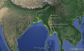
Satellite image showing the Pyu area of settlement with the location of Beikthano and Sri Ksetra. (Google image, annotated by Janice Stargardt)

The Pyu shared a form of urbanism on a range of scales — from vast walled spaces with one side enclosed by a water tank (as at Sri Ksetra and Beikthano), or a tank just outside the walls (as at Halin, Pinle and Wadi); a homogeneous form of irrigation technology integrated into these settlements with adaptations to suit each specific environment; a high-grade silver coinage with a srivatsa symbol on one side and either a rising sun or a bhadhrapitha symbol on the other.Footnote 7 In short, there is no evidence of population change in these two cities, which endured for most of the first millennium (their late phase will only be briefly mentioned in relation to the contraction of the water system and adjustments to the walls at Sri Ksetra).
By the time the first durable structures survived at Beikthano and Sri Ksetra (c. first century BCE), it can be assumed that there were significant preceding stages when dwellings, and very likely ritual buildings, were constructed in non-durable organic materials like wood and thatch. Of the many Late Iron Age villages that probably existed in the Ayeyarwadi Valley in the last centuries BCE, one may ask what attracted settlers to Beikthano and Sri Ksetra, and what conferred on them a degree of continuity and complexity greater than their neighbours? Three common factors emerge, which relate to late prehistoric and early historic settlement patterns elsewhere in mainland Southeast Asia: proximity to a great river, but protection from it; success in controlling water in small perennial streams during the rainy and dry seasons; and abundant, easily extracted iron ore deposits.Footnote 8 Trade was probably also significant, but has left no direct material traces at Beikthano or Sri Ksetra in the last centuries BCE.
Water control and early urbanism at Beikthano and Sri Ksetra
What does urbanism mean, and what distinguished an urbanising settlement from a village? Most fundamental is evidence of a considerable economic and social complexity, e.g. the existence of specialised craft groups and non-food producers, made possible by food security and surplus, either locally sourced or from elsewhere; the emergence of socioeconomic inequalities, leading to hierarchical relationships and evidence of large-scale coordinated activities (such as the construction of monuments, walls and irrigation works); and the urbanising community as a central place within its area. Fortifications and other structures in durable materials are not essential to the claims of a community to be urbanising if it possessed the other characteristics. Writing is not in this list, as surviving material evidence of writing is likely to belong to periods considerably later than the appearance of the fundamental changes outlined above,Footnote 9 and later than the appearance of writing itself on ephemeral materials like palm leaf, cloth and wood.
Pyu cities retained some aspects of a cluster of villages throughout their long history: despite impressive brick walls, defile gatewaysFootnote 10 and brick monuments, their urban terrain was dispersed and highly unevenly exploited. Sri Ksetra contained fields, irrigation canals, water tanks and iron-working sites, as well as monuments, markets (and elusive habitation areasFootnote 11 ) both inside and outside the walls.Footnote 12 I applied the term ‘cities of extended format’Footnote 13 to this characteristic form of Pyu urbanism. They are at present the earliest dated examples in Southeast Asia, but this dispersed, uneven-density type of urban space can be recognised elsewhere from c. the mid-first millennium CE onwards — e.g. at Rakhine, Dvaravati,Footnote 14 Bagan and Angkorian urban sites.Footnote 15 The integration of water control and urban development is conspicuous at Beikthano, Sri Ksetra, as well as at other Pyu sites that fall outside the scope of this article.
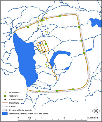
Map of Beikthano and its irrigation works (maximum extent) (© Gabriel Amable and Janice Stargardt)

At BeikthanoFootnote 16 the settlement was located just upstream from the convergence, from the southwest and northeast respectively, of four perennial but highly seasonal streams draining the Yin Valley.Footnote 17 The site is approximately 15 km east of the Ayeyarwadi and separated from it by dry lands through which the Yin flows. Whereas all other settlements in the Yin Valley as far east as Taungdwingyi had access to only one or, rarely, two streams, the water resources in the Beikthano locality were superior and probably critical for its early development, in an environment where the average annual rainfall (870 mm) makes the cultivation of rainfed traditional rice unstable.
Sri KsetraFootnote 18 is only 5.8 km east of the Ayeyarwadi River, but sheltered from it by the Myinbahu Ranges (maximum altitude 164 m above mean sea level [amsl]). Here the Pyu mastered three more difficult slope factors than at Beikthano: a very steep slope from the ranges descending from an average of c.140 m to 63 m amsl over the short distance of only c.2.5 km from the west and southwest of the site; a much more gradual slope from the northeast where the Nawin River flowed westwards to join the Ayeyarwadi at Pyay (Prome); and a gentle slope towards the southeast outside the eastern side of the ancient city. The Nawin River passed close to the north side of the future walled area of Sri Ksetra and through an easily defensible gap in the Myinbahu Ranges. Though Sri Ksetra benefits from more rain than Beikthano, with an anual average of 1200 mm, this is still not enough to support rainfed traditional rice. The city gradually developed the largest and most intensive of the Pyu irrigation systems.
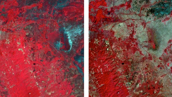
River diversions and rain capture through weirs, canals, moats, ponds and storage tanks were practised in both Beikthano and Sri Ksetra, and were so accurately inserted into their local environments that parts of them still function some 2,500 years later.Footnote 19 It can be assumed that experiments with water control accompanied early settlement in Sri Ksetra, to protect habitation areas and burial terraces from the effects of the powerful run-off from the Myinbahu Ranges during and after the annual rains from June to September, and to store water for use thereafter (figs. 3, 4a and 4b). The environment around Sri Ksetra is saturated immediately after the rains (fig. 4a), but much of the water has run away four months later (fig. 4b), except where it is still collected in ancient irrigation works, often at a sub-surface level.
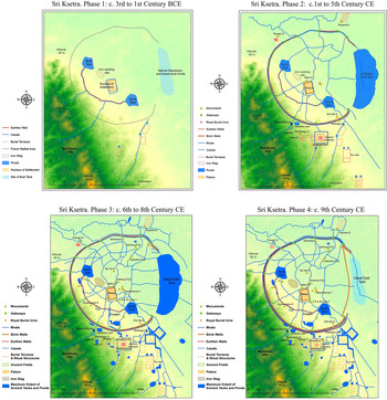
Sri Ksetra and the four phases of its irrigation works (© Janice Stargardt & Gabriel Amable, Univ of Cambridge)

4a (left), Satellite image showing the generally saturated environment at Sri Ksetra, September 2002; 4b (right), Satellite image showing differentiated wet and dry land at Sri Ksetra, January 2003 (© Gabriel Amable and Janice Stargardt)

Figure 3 (Phase 1) shows the beginning of those works in a single trench running in a curve across the southwestern/western slope of the site at c.50 m amsl, with a storage tank at each end of the trench, and an earthen rampart on its downslope side (probably made from the earth dug out of the trench).Footnote 20 I consider them to be the oldest traceable elements in Pyu hydraulic development (fig. 3, Phases 1–3). This early trench was aligned to trap some of the run-off, divert it away from the settlement, and store some in the two tanks for dry season use. These early works must have developed through trial and error, probably from c. the fourth or third to first centuries BCE.Footnote 21 In the same period, a short distance to the north, increasing quantities of water were being diverted by simple weirs out of the Nawin into canals and ponds for rice cultivation after the end of the rainy season.Footnote 22 There were no doubt other works too small to identify, but these skills in water control enabled the Iron Age Pyu communities settled here to cross the vitally important thresholds of food security and food surplus which accompanied the transition to urbanising societies in low rainfall areas.
The massive southwestern and western walls of Sri Ksetra, built of fired brick with a brick-lined moat, initiated a second phase in water control. They ran approximately parallel to the curving trench, but c.550 m closer to the Myinbahu Range along the 63–0 m amsl contour, and now employed the great East Tank as the main storage and distribution area (fig. 3, Phase 2). They represented works of water control and storage on a greatly increased scale and solidity, but they clearly grew out of the same localised knowledge embodied in the original trench, embankment and smaller storage tanks, which still existed as a backup system. The early stages of the brick western wall and moats were probably begun between the first century BCE and the first and second century CE as related activities, but both were rebuilt, improved and extended many times over the centuries thereafter during the long life of the city.Footnote 23
The burning of a wooden gate in one defile gateway in the East Wall at Beikthano has been radiocarbon dated to 210 ± 30 CE, and another to 325 ± 25 CE.Footnote 24 I date Phase 2 of the wall and moat-building at Sri Ksetra to the period from c. the first century BCE to the sixth century CE; Phase 3, to the sixth to eighth century; and Phase 4 to the ninth century. As Phases 1–3 were long continuous processes of experimental construction and reconstruction, these dates are not meant to represent sharply distinct phases. Fig 3, Phase 3 shows the maximum extent of both the brick fortifications and irrigation at Sri Ksetra, while Phase 4 is a short late phase of contraction of the water system and adjustments to the walls. All four phases and their chronological associations will be discussed further below.
Pyu funerary culture at Beikthano and Sri Ksetra: From prehistory to early urbanism
The first brick buildings
There is limited evidence that Beikthano was settled in a pre-urban, Iron Age phase. Inside what later became the fortified palace-citadel area, an exceptional concentration of late prehistoric potsherds was found during excavations ‘extending into the ground below the last course’ (lowest course of brick). This was first interpreted as infill,Footnote 25 but subsequently interpreted as ceramic debris from an unusually prosperous late prehistoric settlement on the site of the future palace-citadel (fig. 2, ceramic debris).Footnote 26
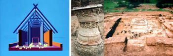
More abundant evidence on the development of economic and cultural complexity at Beikthano is provided by three huge pillared halls built of wood and brick (KKG9, 10 and 11). KKG9's external brick walls measured 25.2 m long x 14.7 m wide x 1.27 thick. The maximum height to the top of the gable roof is estimated at 10 m, and of the brick walls at 8 m (fig. 5a). The dimensions of KKG10 were not recorded as it was left only partly excavated in order to concentrate on KKG9, which partly covered it. KKG11's brick walls were similar to KKG9, at 26.4 m long by 14.4 m wide and c.1.27 thick, with a similar estimated maximum height. Each hall incorporated an immense volume of bricks, estimated at 805 cu. m each.
5a (left), Wood-and-brick halls at Beikthano with multiple cremation burials in urns (elevation above 2m conjectural) (© Janice Stargardt and Gabriel Amable); 5b (right), Mainly brick monuments at Beikthano with multiple cremation burials in urns (© Archaeology Department of Myanmar)

C14 dates based on two samples of young charred wood from KKG9 (side braces) were obtained in 1969. Calibrated, they extended from 196 BCE to 246 CE, and 105 BCE to 305 CE.Footnote 27 KKG10 was older than KKG9, with a similar structure and cultural content. Calibrated C14 samples from KKG11 were dated at 90 to 535 CE and 150 to 600 CE.Footnote 28 This spread of dates is frustrating, but they become more useful viewed with more recent AMS dating below.Footnote 29
The Beikthano wood-and-brick halls were built with a rectangular external wall of large bricks with a single entrance on the short axis. KKG9 and 10 were orientated north–south, while KKG11 faced east–west. The internal structure of each of these halls, identifiable only by significant cavities and charred remains, consisted originally of four pairs of wooden columns, each over 60 cm in diameter, with smaller wooden side braces slotted into the brickwork about 1 m above the rammed earth floor.Footnote 30 The now largely absent interior elements in wood originally carried the considerable weight of the superstructure. Roof beams and roof must have been in wood and thatch, as no tiles were found. This accounts for the large volume of iron nails, hinges and brackets found in each hall.
Iron in Myanmar predated its prolific appearance in these early Pyu structures (first century BCE). It was found in c. fifth century BCE at the Iron Age site of Taungthaman, in the middle Ayeyarwadi Valley in crude form,Footnote 31 and ‘prior to the 4th century BC’ at Ywa Htin in the Samon Valley.Footnote 32 The origins of iron-working in Myanmar — indigenous development or imported technology — have yet to be clarified. In India it is much more ancient; in Thailand, it appears at a similar date to Myanmar (Higham, this vol.).
The three halls at Beikthano have a multiple significance: they preserve rare evidence of a period of technical transition: from the type of all-wooden pillared houses and halls central to vernacular Southeast Asian architecture, to the mainly brick monuments of early urbanism. They provide important insights into Pyu funerary culture, and they illuminate the levels of social and economic complexity reached at Beikthano. They incorporated an array of resources, ranging from large and small straight trees for the columns, beams and side-braces, to large quantities of iron artefacts, a variety of terracotta urns, to the huge volume of bricks. These resources must have been matched by the social skills to mobilise the raw materials and coordinate their production and use by the specialised builders and potters involved in these projects.Footnote 33 The halls also provide evidence of a powerful belief system in the elaborate provisions for the dead — who should be buried together, in what type of urn, in what location inside or outside each monument and excluding others from being added to each assemblage. The criteria given above for an urbanising society point to the significance of such features. They indicate the existence of such processes at Sri Ksetra and Beikthano over the broad period described by the radiocarbon dates.
KKG9 at Beikthano provides the earliest dates so far for bricks and brick construction in Southeast Asia as a whole.Footnote 34 The size of the bricks is also significant: c.50 × 25 × 7.5 cm (or a mathematical ratio of c.1: 0.5: 0.15). These dimensions are close, almost certainly not by chance, to the norms of the bricks of the Asokan period at Pataliputra which became a widely adopted standard in India from the mid-third century BCE, onwards. Bricks of this type were in use in the early Buddhist sites of the Deccan and Andhra from the late-third to early-second centuries BCE. The production of Asokan-type bricks at Beikthano and Sri Ksetra reflects technical contacts with India at some time in the period indicated by the C14 dates above. AMS dates presented below suggest the time spread to be c. the first century BCE to first century CE. Technical contacts with India are much clearer, earlier and easier to identify in this period than cultural.Footnote 35
In all three of Beikthano's pillared halls, the cultural contents were the same: only urns with calcined human bones, ash and earth. Large ones were grouped around pillar bases, small plain ones near doorways and along walls. All were then covered with earth and compacted, which simultaneously shattered the urns but held them in place.Footnote 36 The urns lend themselves to ranking in terms of size, decoration and location inside and outside the halls: forty at KKG9, about six only inside the hall at KKG10, including some of the finest, and thirteen at KKG11.Footnote 37 The presence of three similar halls at Beikthano, representing large material investments, indicates that funerary rituals already occupied a central position in Pyu culture in the transition from late prehistory to early urbanism.
Excavations at Sri Ksetra were resumed in 1992 and at Beikthano in 1995.Footnote 38 Work done from then until 2011 at both sites has confirmed the significance of early funerary assemblages by revealing many additional examples. Many of the terracotta burial urns excavated since 1995 were typologically related to those at KKG9, 10 and 11, but a minority were more elaborate, with appliquéd and rouletted decorations not found previously at Beikthano or other Pyu sites (fig. 5b, inset). Terracotta urn assemblages were installed in still greater numbers in the mainly brick monuments described below.Footnote 39 The largest number found so far in a single monument of this type at Beikthano is 103.
The mainly brick monuments, e.g. BTO20, 28, 30, 31, 32, 33, and 34, with their remarkable urn assemblages, mark an architectural development from the three earlier, transitional wood-and-brick pillared halls. Figure 5b shows that the mainly-brick monuments of Beikthano were substantial, and also built with the very large bricks of the earliest Pyu brick structures. They sometimes comprised a main chamber surrounded by several smaller brick-built chambers. Monuments of this type still contained some wooden elements. Figure 5b reveals two embrasures per wall and one in each of four corners, where much thinner, dressed wooden pillars originally stood embedded in the brick walls. Their purpose was probably to provide secure connections with the wooden roof beams, rather than to support their weight, as was the case in the wood-and-brick halls. They show that the Beikthano builders were now confident that the brick walls could support the roof without a central framework of great timber pillars occupying the interior space of the monument, but had not yet solved the problem of how to attach the wooden roof beams to the brick walls.
This evidence reveals how the mastery of brick-building techniques came slowly to Pyu craftsmen during the period from the last centuries BCE to the first centuries CE. The two phases of early brick monuments at Beikthano prove that the Pyu builders were familiar with the techniques of wooden architecture, but progressing in their control of a relatively new material — brick. BTO32, one of the mainly-brick structures with some of the most elaborate terracotta urns, has provided an AMS C14 date calibrated to 60–220 CEFootnote 40 (fig. 5b shows BTO20a, a similar monument and urn assemblage).Footnote 41 Not only are the monuments of this type better dated by AMS than their predecessors, to a time between the mid-first and early third century CE, but they also clarify the wide spread of the C14 dates from the preceding phase of wood-and-brick halls, suggesting that c. first century BCE to early first century CE is probably the most relevant part of their development.
The cultural contents of the mainly brick monuments remained the same: cremated human remains, earth and ash in terracotta urns, without any Indic religious artefacts. These monuments of Beikthano confirm all the urbanising implications already identified, namely the existence of a complex, highly productive society and economy capable of major projects. While Indic religious artefacts are absent, Indic ceramic technology can be seen in the complicated appliquéd and rouletted designs on a minority of the funerary ceramics. Such artefacts provide glimpses of a society whose hierarchical differences were reflected in its arrangements for the dead.
Examples of wood-and-brick pillared halls with multiple cremated urn burials have also been found at Sri Ksetra; at sites numbered HMA9, 10, 11, 22, among others excavated in the 1960s and early 1970s for which I have not seen detailed reports.Footnote 42 Some of their dimensions resemble their counterparts at Beikthano, c.25 m by 14 m. Together with the better documented and dated wood-and-brick and mainly-brick halls at Beikthano, they form the earliest surviving monumental Pyu architecture.
In particular, these groups of buildings document stages of architectural development taking place in parallel at both sites from the second–first century BCE to the first–second century CE, from late prehistoric all-wood architecture to wood-and-brick, and then to mainly-brick ritual structures. The largest pillared hall of the wood-and-brick type was HL9 at Halin.Footnote 43 While Pyu monumental architecture underwent important transitions, their funerary contents reveal continuity of funerary culture and some technical developments in pottery decoration.
In spite of the evidence of technical influences from India in the use of brick of Asokan norms, ceramic techniques and possibly iron technology, none of these early monuments at Beikthano or Sri Ksetra reveals traces of Indic religious influences, unless the practice of cremation burial itself is judged to be one. As this is widely thought to be the case by Myanmar archaeologists, it requires careful consideration. Inhumation burials predominate at the Bronze and Iron Age sites of Myanmar: in the Samon Valley, at the Iron Age site of Taungthaman in the middle Ayeyarwadi Valley, and also in Stone Age levels at Halin in the Mu Valley.Footnote 44 They continue as a minority practice together with cremation burials in urns into the historic period at Halin. So far, only one inhumation burial has been reported in or near Sri Ksetra among thousands of cremated urn burials there,Footnote 45 and at Beikthano they are also rare. Out of an estimated total of over six hundred cremated urn burials excavated so far at Beikthano, only two primary inhumation burials and three secondary burials have been reported. Uncremated infant burials in terracotta urns were common in the Iron Age Ywa Htin cemetery in the Samon Valley.Footnote 46 Archaeological surveys in 1903–04, however, noted isolated prehistoric clusters of cremated urn burials (‘Pyu sepulchres’),Footnote 47 in Yamethin district, Meiktila division ‘two-and-a-half miles from the Nyaunglun Railway Station’.Footnote 48 Thus one can conclude that several different burial traditions coexisted in late prehistoric Myanmar.
Small numbers of monastic cremation burials in urns were found in stupa foundations at Nagarjunakonda in Andhra.Footnote 49 The practice of monastic cremation burials inside small stupa-shaped monuments continues up to the present in both Myanmar and Thailand, but these are always single burials or, rarely, of a few individuals. While the Pyu practice of cremated urn burial may possibly have been prompted or strengthened by early contact with Indic Buddhism, neither the urn types, nor the numbers forming the groups buried in and around a single Pyu monument, nor the monuments themselves bears any resemblance to those in early Buddhist India. These factors, taken together with the C14 dates from Beikthano obtained from two phases of funerary monuments without Indic artefacts, suggest that Pyu cremation and multiple urn burial predate their adoption of Buddhism. We shall see below, however, that the Pyu tradition of cremated urn burial continued, integrated into Buddhist traditions, from c. the middle to late first millennium CE. Examples of human burials have recently also been reported from early Buddhist sites in Thailand.Footnote 50
Multiple and sometimes massed cremation burials in urns are found in huge numbers at Beikthano and Sri Ksetra in both pre-Buddhist and Buddhist contexts. They were installed in groups inside the specifically funerary wood-and-brick, and mainly-brick halls at Beikthano and Sri Ksetra; many hundreds (occasionally thousandsFootnote 51 ) were installed in each of the stepped burial terraces at Sri Ksetra, examined below, and they also surrounded almost every stupa-shaped monument at both Beikthano and Sri Ksetra in significant numbers.Footnote 52 Whether one accepts that cremation burial itself was a Pyu prehistoric practice that continued into urban contexts, or considers it might possibly originate with, or have been strengthened by, their early contacts with Buddhist India, it is clear that the way the Pyu practised it had no precedent in India. Grouped cremation burials were central to late first millennium BCE Pyu funerary culture, were carried forward into the historic era and integrated into the Pyu forms of Buddhism throughout the first millennium CE.
Burial terraces are a particular feature of funerary culture at Sri Ksetra, which have not, so far, been found at other Pyu sites. Nine were known prior to 2012, but surface surveys are finding many more, extending 10 km south of the city walls as far as Thegon, and north of the city walls for c. another 10 km.Footnote 53 Figures 3 (Phases 1–3), and 4b indicate that there were at least nine major burial terraces outside the southern city walls, adjacent to and south of the Bawbawgyi, Bebe and Lemyethna Buddhist monuments (including the complex at Beikthanomyo, or the ‘Queens’ cemetery’).Footnote 54 There is also a major burial terrace outside the northeast city walls, adjoining the Payama Stupa, and outside the northwest walls a royal burial terrace once adjoined the Payagyi Stupa.Footnote 55
These burial terraces possess affinities with the great pillared halls. They were constructed alone and in combination with other structures of brick, wood and rammed earth in large complexes known as Pyu taiks or daiks. The character of these other structures is not always identifiable, possibly for monastic or other undefined rituals, but the primary function of the burial terraces is clear: they contained hundreds or even thousands of cremated urn burials.Footnote 56 Terraces varied in size; some were relatively compact, measuring c.30 by 60 m, but some were surrounded by brick walls enclosing spaces almost as large as the central palace area (575 by 375 m).
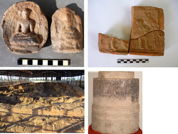
Burial terraces were formed by placing terracotta urns, containing cremated human remains, ash and earth, in rows or groups on the natural surface, then covering them with compacted earth onto which further urns were deposited. These processes were continued to form a series of two, three, or rarely four, diminishing rectangles making a stepped terrace. The steps were sometimes faced with bricks, and the flat upper platforms were made either of unpaved rammed earth or covered with a solid surface (fig. 6d). A large terrace undoubtedly took a considerable time to complete. Two C14 dates are currently available for burial terraces at Sri Ksetra: HMA47 and 53, locations shown on fig. 3, Phase 2. Both dates belong to c. the mid-first millennium CE,Footnote 57 but the archaeological associations of these dates are unclear. The HMA47 carbon sample came from a large charred pillar with a diameter of c.30 cm. Thus one must consider the problem of old wood; the date from HMA53 is based on ash and carbon from the uppermost level of this burial terrace — datable materials from its lower levels have yet to be obtained. The very large burial terrace just inside the Yahanda Gate, excavated by Charles Duroiselle in 1923, contained no Indic religious offerings among the thousand terracotta urns with cremated human remains which he lifted nor it seems, among the thousands he left in situ among scattered iron fragments.Footnote 58 This example raises the possibility that Sri Ksetra's burial terraces are pre-Buddhist in origin, and may belong — with the wood-and-brick, and mainly-brick halls of Sri Ksetra and Beikthano — to the oldest surviving phases of Pyu ritual architecture and funerary culture. Burial terraces at Sri Ksetra certainly have a very long history, as is visible in the area outside the southern walls of the city where some are so old that their traces on the satellite images are almost obliterated; later burial terraces and canals cut across and are built partly over earlier ones (cf. fig. 3, Phases 1, 2 and 3, and fig. 4b).
(Clockwise from top left), 6a, Buddhist clay sealings, c. 5th–6th century style found in burial terrace HMA47 at Sri Ksetra (© Archaeology Department of Myanmar [ADM]); 6b, Bull clay sealing, standing, with bells on collar and long-stemmed lotus [?] in mouth, found in burial terrace HMA47 at Sri Ksetra (© ADM); 6c, The largest stone burial urn, with royal genealogy, from Sri Ksetra 1992–93 (© ADM); 6d, Burial terrace HMA53 at Sri Ksetra with 350 massed urn burials; conserved without the brick pavement that originally covered at least part of the upper surface (© Janice Stargardt, 2013)

Archaeological surveys and excavations at Sri Ksetra in the 1920s, 1930s and 1960s noted abundant traces of nails and sometimes broken tiles on these burial terraces, thus indicating that, at least sometimes, they originally possessed a superstructure in wood, sometimes tiled, of which only the basal terraces often remain.Footnote 59 The affinities of the Sri Ksetra burial terraces with the wood-and-brick halls of Beikthano and Sri Ksetra, emerge more clearly from the fact that at least some of them had large wooden pillars and a roof.Footnote 60
Buddhist and Hindu artefacts do occur in some burial terraces, for instance, in the two dated terraces mentioned above: HMA53 is a three-stepped burial terrace containing at least 350 cremated burialsFootnote 61 grouped in terracotta urns of several types and sizes (fig. 6d). Buddhist clay sealings (votive tablets) and one mould were found in this terrace (location details unavailable).Footnote 62 Burial terrace HMA47 contained Buddhist clay sealings dating stylistically to the fifth–sixth century CE (fig. 6a; location details unavailable). The stylistic dates seem to correlate quite well with the latter's AMS C14 dates of 420–570 CE, but the problems of old wood and association have been noted. HMA47 also contained a beautifully designed clay sealing depicting a standing bull in profile (fig. 6b).Footnote 63 No comparable artefact has been recorded from India or elsewhere in Southeast Asia.Footnote 64 The plaque is thus of great rarity: standing bulls appear on coins of Sri Lanka, and the Pandya and Pallava of South India, but never holding something in their mouths.Footnote 65 Recumbent bulls are more common as symbols on coins and sealings than standing ones, but there is one example of a standing bull from the Saivite Cave 29 at Ellora, dating from c. the early seventh century CE, wearing a collar with bells behind the hump, but not carrying anything in his mouth.Footnote 66
The context of this sealing has to be kept in mind: it was deposited among a Pyu funerary assemblage in which Buddhist offerings predominated, as they did in other localities of c. the mid-first millennium CE at Sri Ksetra discussed below. Many scholars have noted that Pyu silver coins and the numerous intaglio stone ring seals of this period found in and near Sri Ksetra bear Hindu motifs: conch, rising sun, srivatsa, wheel, trident, vajra.Footnote 67 More recently, the pool of sacred symbolism is seen as not strictly divided between Hindus and Buddhists, but rather as shared by them in the first millennium.Footnote 68 The Pyu had many contacts with Andhra where, for instance, the kings of Nagarjunakonda carried out great Vedic royal rituals like the asvamedha sacrifice, while their royal mothers, wives, sisters and daughters — and possibly they themselves — were generous patrons of Buddhism. Among the Pyu, the presence of this possibly Saivite bull symbol among early Buddhist sealings suggests the existence of an holistic tradition in which the Hindu gods were worshipped as protectors of the Buddha. Such holistic approaches are further indicated by the merging of Indic religious symbols with the indigenous Pyu rituals of groups of cremated urn burials.
These two dated burial terraces of Sri Ksetra, in spite of the problems of the associations of their AMS dates, represent a very important cultural benchmark. They document the merging of the Pyu tradition of massed cremation burials with religious devotions of Indic inspiration. Both terraces provide approximate objective dates indicating that around the mid-first millennium CE, such devotions existed on a popular level at Sri Ksetra, in contrast to the approximately contemporary treasures of the Khin Ba relic chamber, which was an elite (probably royal) foundation.Footnote 69 These two burial terraces at Sri Ksetra show that religions of Indic inspiration had become widespread among the population of Sri Ksetra, but without effacing their pre-existing funerary traditions. Further research on the burial terraces and Pyu taiks of Sri Ksetra is needed to provide more evidence on the stages and dates of such significant changes in Pyu funerary culture, and its fusion with Indic religious devotions. A small number of stone Visnu statues have also been found at Sri Ksetra (now in the Hmawza site museum), but they appear to belong to the second half of the first millennium.
The stone burial urns of Sri Ksetra: The Vikramas
Another important elaboration of Pyu funerary urn culture — this time for the elite — took place at Sri Ksetra around the middle of the first millennium, with the creation of large urns formed out of a stone block, externally shaped into a soberly decorated cylindrical stone jar with flat base (fig. 6c). A recessed flange was carefully carved around the upper edge, over which a flat circular stone lid was fitted. The interior was hollowed out to form a cylindrical interior space. Four such stone urns were found and excavated in 1912 in the old burial terrace already listed, 70 m south of the Payagyi Stupa, outside the northwest walls of the city. They are between 75 cm and 1 m high, with a circumference of about 1.5 m and carry a one-line inscription mainly in Pyu. One has a longer inscription on its base.Footnote 70 A single urn (the largest so far), was found in 1992–93 inside the city walls to the east of the palace.Footnote 71 The inscriptions on all these five urns at Sri Ksetra show, from the names of Sanskritic origin assimilated into the Pyu language, that they were for royal burials.
The inscribed stone urns of Sri Ksetra open up areas for epigraphic and historical research which lie beyond the scope of this article. It is, however, of great significance to the themes treated here to note that these urn inscriptions afford the first direct evidence of people who styled themselves kings, using Indic names and titles with an historic resonance in their contemporary world. They may have been the rulers and patrons of many early Buddhist works at Sri Ksetra in the same period — the fifth–sixth century CE — including the elite Khin Ba relic chamber. They enjoyed sufficient wealth to command the production of these huge stone urns to preserve their cremated remains, and to commission the expert scribes who preserved their names and some key dates.
Distinguished work has been done on these Pyu stone-urn inscriptions,Footnote 72 but it has not previously been noted that on all five urns — and especially the last — the palaeography was highly developed. The inscriptions were expertly carved into hard stone surfaces, showing great regularity and elegance of letter sizes, and exactly even spacing between letters and lines (fig. 6c). They represent, not the beginning of Pyu literacy — as has repeatedly been stated — but rather a developed stage of it in their own language, datable on palaeographical style to c. the fifth or sixth centuries.Footnote 73
The largest stone urnFootnote 74 (fig. 6c), has a circumference of over 2 m. It was found embedded in the centre of a brick-built stupa near the Hpayahtaung temple. Its beautifully carved five-line inscription in Pyu contains 1,127 letters of which 1,050 are still clearly legible.Footnote 75 There are Sanskritic royal names, other titles,Footnote 76 and some Pyu numbers. Among the six names, four end in –Vikrama Vam,Footnote 77 an epithet meaning the valiant or heroic. Three were already known from the urns inscribed with a single line, but this inscription may establish their place in a genealogical sequence.Footnote 78 A fifth–sixth century dating hypothesis finds some support in the palaeographic style.Footnote 79 All five urn inscriptions, though at present not fully understood,Footnote 80 have the potential to provide the earliest written information to date on a dynasty in Sri Ksetra c. fourth–sixth century. It is relevant too, to the theme of this article, that the Vikrama kings at Sri Ksetra, with their Indianised names or titles nonetheless adhered to Pyu traditions of cremation and burial in urns associated with Buddhist monuments.
Early urban features at Sri Ksetra — iron, walls and water
Iron
At Sri Ksetra, the earliest C14 dates currently available are associated with a large iron-working locality called Tabet-ywa 120 m northwest of the future palace area, c.2 m deep and covering an area of c.1.4 ha (fig. 3).Footnote 81 Carbonised fragments of slag, from a low level in the heap, have provided a calibrated AMS date of 50–200 CE.Footnote 82 Again, this spread of dates is wide, but it does point to proto-urban or early urban levels of complex socioeconomic activities at Sri Ksetra by c.first–second century CE. They also agree with the AMS dates for the mainly-brick monuments with multiple urn burials at Beikthano. Current research has revealed abundant evidence of a high volume of iron-working in and around Sri Ksetra, including along the crest of the Myinbahu Range. Nearby, many accessible ore seams have also been identified and so far 84 single-use iron furnaces have been plottedFootnote 83 where ore was heated to a temperature adequate to make sponge iron, then possibly cold-hammered and forged into specialised artefacts.Footnote 84
The Pyu use of iron suggests that it possessed more than utilitarian values for them: huge iron spikes, c.75–100 cm long, have been exposed in gateways and were driven into the earth near the corners of brick structures (e.g. the southwest corner of the palace walls). They have been found scattered over the burial terraces and on the slopes of the Myinbahu Range among the remains of small stupas with multiple cremated urn burials.Footnote 85 In all these cases, they appear to assure defence against supernatural as well as human enemies.
Walls and water at Sri Ksetra
It was suggested above that the brick walls at Beikthano and Sri Ksetra represent a long, cumulative activity of building and rebuilding, starting around the first century BCE, extending over many centuries and consuming huge volumes of fired bricks. In many respects, the study of the wallsFootnote 86 is also the study of the evolving urban character of these two sites. Furthermore, I propose that wall-building and rebuilding was one part of a dual process whose other part consisted of the construction, repair and extension of combined water storage and irrigation works, and that the exigencies of water control originally determined the course of the walls. Later modifications included a degree of cosmological symbolism.Footnote 87 The cumulative nature of wall-building is demonstrated by changes in dimensions, alignments and materials.Footnote 88 At Sri Ksetra it is particularly clear that the outer city walls and walls around burial terracesFootnote 89 and the palace area were linked with water movements along canals and moats.Footnote 90
The outer walls of the Pyu cities enclosed vast spaces: at Sri Ksetra c.1,847 ha, at Beikthano c.900 ha and at Halin c.500 ha, and at all three sites there were extensive extramural developments as well. These facts alone make it probable that the walls resulted from protracted building works. The outer walls at Sri Ksetra are particularly impressive; parts of the brick western wall, vital in protecting the city from the powerful floodwaters, still stand to a height of 4 to 6 m in places and vary in thickness between 2 and over 5 m. This brick wall was duplicated by at least one outer earthen wall at some date to strengthen resistance to the water running downslope from the Myinbahu Range.Footnote 91 Variations in wall height, thickness, duplication and even triplicationFootnote 92 are also evidence of long processes of construction and repair. The v-shaped bottom of the brick-lined moat between the two western walls was 5.1 m below the present ground level.Footnote 93 This moat followed the walls for at least 8 kmFootnote 94 and continued around the city, possibly without brick linings for at least 27 km, not counting the duplications and triplications. The brick facings and moat depth show that the western side had to be strengthened to resist the powerful seasonal flows (fig. 4a).
Colonial studies of traditional irrigation in Myanmar were impressed by their technology, noting the way farmers allowed water to indicate where it could flow and then both followed and directed that flow through their canals and walls or embankments; they also noted the skill shown in reducing the erosive forces of water by conducting it along curving routes.Footnote 95 Both these techniques were employed effectively in Sri Ksetra's water-and-wall-building system. The first brick walls, running along the 63–0 m contour on the southwestern and western sides of Sri Ksetra, were probably in part as old as other Pyu experiments with brick, c. first century BCE to first–second century CE (fig. 3, Phase 2). Like the Phase 1 trench and earthen rampart, they traced a curved alignment, and were hence better able to withstand the water pressures than a straight surface at right angles to the direction of flow, and also to reduce water erosion more effectively.
The western walls of Sri Ksetra and the western moat were then gradually extended downslope towards the northeast, following a generally curving route until they reached the 33 m amsl contour on the northern side. There they encountered the second prevailing slope from the northeast, which obliged the builders to curve both walls and moats towards the east and southeast, exploiting slight downward slopes from 34–33 m amsl near the northern corner to 32–31 m amsl at the northeast corner of the site. Just around that corner, the great walls stopped, because the water flowed unguided southwards into the lowest level of the site, the depression occupied by the great East Tank (fig. 3, Phases 2 and 3, figs. 4a and 4b). A shorter movement of water has been traced from the southwestern corner of the site, where water entering the moats flowed along a curved but shorter route downslope along the southeastern edge of the city and into the East Tank. We shall see below, how the heavy water pressures along this shorter route necessitated the construction of additional channels for water control and harvest (cf. fig. 7a). From Phase 2 to Phase 3 the East Tank filled the gap between the northeast and southeast walled corners of the site at c.31 m amsl. It too provides further evidence of the protracted, linked nature of wall, moat and tank building at Sri Ksetra. The East Tank also released water seasonally into the irrigated, low-lying fields towards the southeast and south of the city. Thus the alignments of the walls and the shape of the walled city were determined by the water in the moats of Sri Ksetra, which flowed mainly in a circular manner, reflecting with great accuracy the several slopes acting on it.Footnote 96
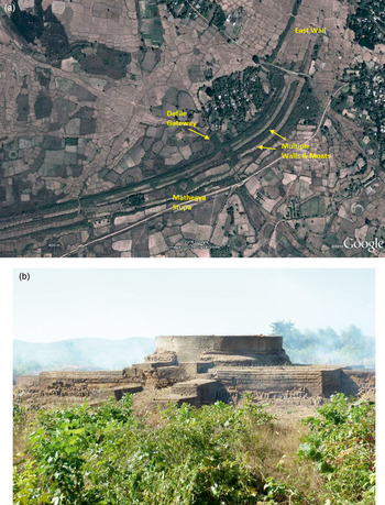
7a, Satellite image of the southeastern wall, gateway, moats and Mathegya Stupa at Sri Ksetra (Google image annotated by Janice Stargardt); 7b, Mathegya Stupa, fifth- sixth century. (© Janice Stargardt)

The first slope, from west/southwest to east/northeast was the most difficult because of the average difference of c. 80 m in height between the crest of the Myinbahu Range and the western edge of the city only c.2.3 km away, and then a further c.33–32 m difference in height between the western edge of the city and the East Tank only 3 or 4 km distant. There was also the problem of the highly seasonal character of the water pressures (figs. 4a and 4b), which meant that from June to early November the water had to be conducted either right around the city into the East Tank to control its huge force and prevent erosion, or more directly into the East Tank from the southwest corner of the city; from early November until the rains began again in the following June, it could be admitted into the city, and allowed to flow towards the palace area. Thence it flowed either directly or indirectly into the East Tank, bringing water to most areas inside the city walls en route (fig. 3, Phase 3). There was thus a seasonal pulsation to the controlled direction of water flows: around the city from June to November and through the city November to June, fragments of which can still be seen functioning at ground-level and even more clearly from satellite imagery.
Until c. the eighth century, constant repairs led to improvements and, in places, to the duplications and even triplications in the moat-wall system just described (fig. 3, Phases 2 and 3, figs. 4b and 7a). The eastern side of Sri Ksetra where the great East Tank once lay is today still called pinle (the sea) by local inhabitants, despite the fact that the modern ground level has been extensively raised and recontoured by the modern Irrigation Department and no traces of the ancient irrigation tank can now be seen from the surface. Under the surface, however, it is still collecting water and affecting the harvests growing above.Footnote 97
The elaborate Pyu gateways probably developed between the first to second century CE onwards, as also indicated by the C14 dates on Sri Ksetra's and Beikthano's gateways.Footnote 98
Later wall- and moat-building at Sri Ksetra can be seen around the elegant stupa known as Mathegya or Gwebindet, c. sixth century CE (fig. 3, Phase 2, fig. 7). As fig. 7a, b shows, Mathegya stands today on a high mound which is a remnant of the ancient ground level at the time of its construction; Mathegya was left in place when an additional southeastern moat was excavated around it.Footnote 99 Still other walls and moats in this area carefully skirted around this substantial monument and must therefore have been built during or after c. sixth century to provide increased water harvesting and control in this corner of Sri Ksetra.Footnote 100 Figure 7a shows the cropmarks of two moats continuing northwards into the sediments of the former great East Tank; it also shows a defile gateway and the southern end of the East Wall, considered below.
In the east of the city there was another major change in the outer walls and hydraulic works at Sri Ksetra. That was the construction of a low, poor quality East Wall along the east side of the site, now often barely visible at ground level but clearly marked by a line of vegetation from the air (fig. 3, Phase 4; fig. 4b and fig. 7a). Since it was first mapped,Footnote 101 the differences in quality and alignment of this wall have been a subject of discussion. Contrasting views continue.Footnote 102 Hudson thinks it is one of the oldest parts of the Sri Ksetra fortifications, while I consider it to be the last, hastily built during a known dry phase in Southeast Asia (eighth to fourteenth century), when the East Tank apparently no longer received enough water to fill the gap between the massive walls on the northeast and southeast corners of the city.Footnote 103 The city must no longer have possessed the resources to build an East Wall to the same standards as the other walls. If the East Wall had existed in the early history of the city, it would have interfered with the operation of the great East Tank as collection and redistribution centre for the Sri Ksetra hydraulic system as a whole (fig. 3, Phases 2 and 3 and fig. 4b); secondly, if it had enclosed the eastern edge of the city throughout most of its long history, it would surely have been rebuilt to the same high standards as the rest of the outer walls?
Conclusion
Transitions from Late Iron Age to early urbanism
What insights do all these materials provide about the transition from pre- and proto-history to history at Sri Ksetra and Beikthano? In fact the two cities provide complementary evidence. Beikthano has provided a small but significant body of C14 dates based on charred remains in wood-and-brick and mainly brick monumental structures, containing large numbers of cremation burials in terracotta urns and no Indic religious materials. The problems of the wide spread of the calibrated C14 dates from the wood-and-brick halls are evident, but combined with the better-dated mainly brick monuments, a persuasive pattern of evidence emerges. It shows that between the first century BCE and the first century CE, Pyu society at Beikthano was economically complex and socially capable of carrying out large-scale construction projects for indigenous funerary rituals, involving several kinds of specialised production. The ways in which urns were grouped in and around the monuments, and the differences among them in size and decoration, indicate hierarchies among the living in Beikthano society, perpetuated among the dead.
At this time, the Pyu enjoyed technical contacts with India, as shown by the brick sizes, and pottery techniques, among others, but there is no evidence of Indic religious influence. The AMS dates show that mass brick production to a significant format went on at Beikthano in the first century BCE, and prolific iron production at Sri Ksetra in the first century CE. This was the period of significant transition at two proto-urban and early urban settlements growing continuously in scale and solidity of materials within particular spaces. The linked processes of wall-building and water control were created by communities with a mastery of other skills in iron-working, brick-making and ceramics, surrounded and supported by irrigated agriculture.
Problems remain concerning the AMS dates belonging to c. the mid-fifth to seventh centuries from the two burial terraces at Sri Ksetra. Data are not available on where the Buddhist sealings were found in the HMA53 terrace. Similarly, at HMA47, data are not available on where the Indic-style clay sealings were found among the multiple cremation urns of this burial terrace. AMS dates more clearly associated with early Buddhism at Sri Ksetra in the early fifth century became available in mid-2015.Footnote 104 At Beikthano at present, there is only stylistic and palaeographic evidence to date its Buddhist culture from c. the third or fourth century CE onwards. A programme of further dating of the extensive urn fields surrounding stupas at Beikthano is needed to explore and date the relations between Buddhism and Pyu funerary practice there.
Excavations and surveys at Sri Ksetra and Beikthano do, however, provide secure material evidence of the existence of two complex ancient societies, comprising farmers and irrigators, brick-makers and builders, potters, iron-miners and blacksmiths, stone masons and carvers, gold- and silversmiths, artists and architects, monks, scribes, scholars, administrators and rulers. What makes these two sites truly remarkable, in the contexts of the transition from prehistory to early historic archaeology in India and Southeast Asia, are their exceptionally well-defined urban spaces with persuasive evidence of continuous settlement over more than a millennium, in which distinct phases of technical development and cultural change have been traced.
Taking the dated evidence of Beikthano and Sri Ksetra together, the material traces of a highly complex Pyu funerary culture predate, by a considerable period, the traces of Buddhist and Hindu culture in Pyu monuments and art. But it is not certain how big this apparent gap really is, because of the fact that the processes of cultural contact with Indic (including Singhalese) cultures would have taken place well before their surviving datable material traces. The evidence presented here leaves little doubt that Pyu society at Sri Ksetra and Beikthano had attained considerable levels of complexity by the first to second century CE. By the fourth and fifth centuries at Sri Ksetra, there were educated resident monks (some of whom were certainly Pyu), widely versed in a range of canonical Pali Buddhist texts, rulers with Sanskritic names or titles who disposed of the resources to endow major Buddhist works, supported by wider sections of the population who, by c. the mid-millennium had integrated Indic religions into their funerary culture. In those processes of change, the agency of already complex, urbanising Southeast Asian communities was of primary importance. Evidence of this is revealed both by presence and absence: in the presence of highly selective, creative assimilations of Indic influences, and by the striking absence of Indic prototypes with Southeast Asian copies. Cultural changes of this kind everywhere in Southeast Asia involved creative processes, leading to recognisably new artistic and architectural styles, new achievements in writing, literature and, as identified here among the Pyu, in the ways they understood and practised religions of Indic origin.