NORTHUMBERLAND
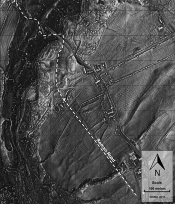
(1) Knaresdale with Kirkhaugh, land near Thornhope Farm, Slaggyford (NY 6860 5119): a watching-brief during excavation of a fibre-optic cable trench across the line of Maiden Way Roman road revealed a low mound, or agger, constructed of silty clay overlain by a stone surface, and a roadside ditch. The route of the road is aligned NNW–SSE and corresponded roughly with that shown on Ordnance Survey mapping.Footnote 72
CUMBRIA
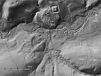
(1) Bewcastle (NY 5682 7421): examination of Environment Agency (Lidar) composite digital surface modelling (DSM) at 1 m spatial resolution has indicated an earthwork feature which has been tentatively identified as a marching or construction camp ( fig. 11). This rectangular feature, located at 154 m OD, measures 148 m east–west and 145 m north–south, enclosing an area of 2.15 ha. No internal features are visible nor are tituli or claviculae. Some gaps in the embankment are to be seen but some may be later access routes. Ridge-and-furrow cuts across the earthwork and appears to post-date it.
Bewcastle. Composite Lidar DSM (digital surface model) with spatial resolution of 1.0 m. (© Environment Agency)

The possible camp is located south of the Kirk Beck and overlooks the crossing point of the Maiden Way, which runs some 100 m to the east. Some trace of this road has been identified on the Lidar image. It is flanked on its western and southern sides by White Beck a tributary of Kirk Beck. Also, the site of a ‘Roman altar’ was indicated on the 1864 OS map and is located between the possible camp and the Maiden Way. The altar is probably the one dedicated to Cocidius (RIB 985), which was said to have been located half a mile south of the stone fort at Bewcastle.Footnote 73
(2) Maryport (?Alauna), Camp Farm (NY 038 372): excavations in 2015 marked the final season in a five-year campaign designed to evaluate the archaeological context of the ‘Maryport Altars’ group discovered in 1877.Footnote 74
Work in 2013 and 2014 had investigated two temples, one rectangular and one circular, which were contemporary with the altars and appear to have been associated with them.Footnote 75 The 2015 season sought to set these temples in their larger landscape. It proved that both temples were contained within a larger cobbled enclosure approximately 50 m by 95+ m and successfully demonstrated boundaries of this enclosure to the north, west and south. The extent of the enclosure to the east could not be established with certainty, but it possibly coincided with a natural gully, about 1.5 m deep, that separated the cobbled area from the high ground where the altars were recovered in 1877. The implications of this are still being explored. On the one hand it appears that the both the rectangular temple and the porch entrance of the circular temple point towards this high point, but on the other there is no evidence for any substantial structures contemporary with them there.
The cobbled surface of the enclosure may well have been where the 1877 altars were erected in the second century; it would have been robust enough to support them without further altar bases. A large free-standing monument certainly stood within the enclosure, as demonstrated by the survival of its substantial foundations. There was at least one entrance, and what might be interpreted as a lodge stood on the north-western side of the complex, 10 m north of the circular temple. The ‘lodge’ only survived to the lower part of its foundations and the floors of its rooms had long since been ploughed away. It was, however, possible to demonstrate that it had already fallen out of use by the late fourth century; it was cut by a ditch which contained Crambeck Parchment ware in its fill.
Of no less interest was the discovery of Roman period ditches under the cobbled area; these are most convincingly interpreted as part of a temporary camp. Still earlier features were identified, including a small structured deposit of the Late Bronze Age period consisting of both Corded ware sherds and quernstone fragments.
COUNTY DURHAM
(1) Binchester (Vinovia) (NZ 2102 3134): the seventh and final season of the new programme of excavation took place in 2015.Footnote 76 The removal of areas of paving within the cavalry barrack revealed lines of post-holes belonging to successive versions of the interior partition walls. Further traces were also revealed of drainage slots in the equine accommodation occupying the front half of the building, while a small oven was revealed in one of the rooms to the rear. Continuing investigation of the decurion's accommodation at the north-east end of the building revealed a complex sequence of structural alteration. The position of the gable wall had been moved several times and on each occasion this necessitated re-alignment of the neighbouring drain running along the inner edge of the intervallum road. An explanation for the widespread subsidence previously noted in this part of the fort was discovered. Prior to the construction of the cavalry barrack there had clearly been a phase in which many large pits were dug in this area, accompanied in some cases by platforms of burnt stones (imported from elsewhere on the site not burnt in situ) and spreads of charcoal and ash. Although as yet undated, this activity may conceivably belong to the later phases in the life of the primary fort in the early second century when, as indicated by the 1970s and 1980s excavations, it became more akin to a works depot represented by extensive iron-working and the dumping of associated waste on the site of the demolished praetorium.Footnote 77
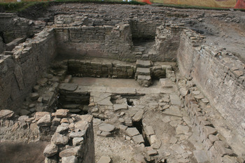
In the area excavated beside Dere Street south-east of the fort work was concentrated on completing the investigation of part of the bath-house previously exposed ( fig. 12). The most significant discovery here was the recognition that the narrow corridor-shaped chamber south of the apodyterium had originally been equipped with a hypocaust and tabulation (giving the total height of surviving masonry as c. 3.2 m). This extended to either side of an early partition wall located immediately east of the original doorway connecting with the apodyterium and is most likely to have been supplied with heat indirectly from the neighbouring circular laconicum. The narrow strip of ground between the bath-house and Dere Street contained a massive accumulation of charcoal and ash deposits, presumably in part at least waste derived from the neighbouring furnaces. The lowest road surface or pavement encountered was level with the internal floor surface of the baths. Numerous re-surfacings of Dere Street interspersed with charcoal deposits lay above this, the latest surface of the road being 2.5 m above the earliest encountered. Exploration in the area north of the apodyterium revealed a small porch attached to the north wall of the latter protecting the original doorway into this chamber which also probably functioned as the main entrance into the building as a whole. The porch was not an original feature and related to a secondary phase of the doorway when it had been narrowed.
Binchester. The apodyterium of the bath-house with the remains of the secondary plunge-bath at the far side overlain by the later base of a stone bench and flight of steps leading down from the doorway formed by cutting down one of the original window embrasures; another embrasure to the left blocked up.

Approximately 9 m beyond the apodyterium lies the east–west wall of fine construction revealed last year partly overlain by a small and late strip-building. A return wall linking it with the west corner of the apodyterium was found this season. This area may have been part of an exercise yard or palaestra.
It is the intention to enclose the exposed portion of the bath-building within a temporary protective structure (funded by the County Council) that will enable visitors to continue to view and appreciate this magnificently well-preserved building for the next year or two while a strategy for the longer term development of Binchester is formulated in collaboration with the Auckland Castle Trust which now owns the majority of the site.Footnote 78
(2) Chester-le-Street (Concangis), Lindisfarne Avenue (NZ 2763 5114): trial excavations in the grounds of several properties on the east side of Lindisfarne Avenue have confirmed the long suspected existence of the bath-building in the area immediately south of the fort's south-east angle. The balneum appears to be of reihentyp design with the apodyterium at the north end of the building. The east wall of one of the chambers to the south was found to be c. 2.5 m in width and may have incorporated the base for a water reservoir.Footnote 79
NORTH YORKSHIRE
(1) Aiskew (SE 27359 89912): archaeological investigations in advance of the Bedale, Aiskew and Leeming Bar Bypass revealed a previously unknown Roman villa located west of Dere Street. The villa was identified by geophysical survey which indicated the presence of a large stone structure along with ancillary buildings set within extensive enclosures. A small part of the western side of the site, that part due to be destroyed by road construction, was fully excavated, with a wider area to the east stripped of topsoil and planned to provide context.
The field within which the villa lay had been in pasture probably since the medieval period until 2014, and therefore structural remains, including intact floor surfaces, were revealed at a very shallow depth below the topsoil. The initial construction appears to have been a winged building comprising a 4 m-wide corridor with rooms projecting to the east at the southern and northern ends. Although the majority of the stone walls of the villa had been robbed during the medieval period, there was limited survival of the 1.10 m-wide westernmost wall of the northern wing. Here up to two courses of sandstone blocks with a rubble core survived, built directly onto a substantial cobble and clay foundation 1.40 m wide and 0.90 m deep; the size of the foundations indicates a two-storey structure. Within the main rooms of the northern wing of the villa, opus signinum floors survived along with small areas of tessellated floor surfaces within the north–south corridor. Complete excavation of a c. 5 m-square room, which was a later addition to the north-western side of the villa, was undertaken. The in-situ bases of pilae stacks demonstrated that this was a heated room and demolition debris within the room included painted wall-plaster. The pottery assemblage demonstrated that the villa was established in the third century with occupation continuing into the late fourth century.Footnote 80
(2) Bedale (SE 2978 8915): the archaeological work in advance of the Bedale, Aiskew and Leeming Bar Bypass also investigated a substantial ditched sub-square enclosure, measuring c. 50 m internally, located c. 1 km to the south-east of the villa and previously identified as a cropmark. The enclosure appears to have been established in the late Iron Age and the ditch had evidently been reinstated on at least two occasions. Two crouched burials were placed within the base of this latest recut. Small quantities of Roman pottery and small finds show that this latest phase of activity continued into the second century a.d. A copper-alloy ‘military’ apron mount hints at connections between the site and members of the Roman army. A regionally significant animal bone assemblage was recovered from the latest fill of the enclosure. This included cattle, sheep, pig and horse, with bones from very young calves indicating animal husbandry. Wild species such as red and roe deer and a few fish bones had also been recovered. As well as evidence for butchery, the bone and antler assemblage included many worked objects, such as decorated weaving combs, serrated rib bones and a finely worked bone ‘toggle’, as well as waste from bone- and antler-working. There was also plentiful evidence for copper-alloy and iron-working: metal-working waste such as crucibles, smithing-hearth bottoms and copper-alloy offcuts, along with a significant assemblage of copper-alloy and iron objects. No internal features survived inside the enclosure due to plough truncation; however the material recovered from the ditch demonstrates that in its latest phase of use during the Roman period, the site was a significant focal point for manufacturing, processing and craft-working activities.Footnote 81
(3) Norton-on-Derwent, land off Langton Road (SE 79654 70375): following on from desk-based assessment and geophysical survey, nine archaeological trial-trenches revealed two phases of activity: Roman on a lower terrace and medieval on an upper terrace. Large palaeochannels were also present on the lower terrace. The artefacts recovered include second- to third-century a.d. ceramics. Informative environmental evidence was present in features from both phases; the crop types represented are typical of the Roman and medieval periods in England, and there is potential evidence in the plant assemblage for the use of turfs as fuel in the earlier Roman phase. The general absence of structural features may suggest that the focus of settlement lies in the wider vicinity of the site.Footnote 82
YORK
(1) York (Eboracum), 20 Bishophill (SE 59972 51403): a watching-brief was undertaken and two evaluation trenches excavated 10 m to the east of the scheduled medieval City Walls of York. A possible robbed-out wall and a fourth-century buried soil were revealed at a depth of 1.6 m below ground level. There was evidence for cobble, gravel and mortar surfaces with redeposited fragments of painted plaster immediately to the east. It is clear that the site lies close to a mid- to late Roman building, if not over a domestic dwelling within the colonia of Roman York. The pottery assemblage, painted plaster and other finds point to a relatively high-status dwelling with the caveat that the material may have come from elsewhere in the city.Footnote 83
EAST RIDING OF YORKSHIRE
(1) Near Elloughton: a second season of excavation was undertaken on a Roman site associated with a minor Roman road leading to the river Humber.Footnote 84 In Trench BA the apsidal end of the large building sampled in 2014 was revealed. Although heavily damaged by demolition and ploughing, it had once been very well appointed. The walls had been adorned with polychrome wall-plaster in at least five colours and the floor with figured mosaics. Some tesserae found amongst the demolition debris were still stuck together and comprised at least four colours. The largest piece, although only about 50 mm square, made up a guilloche pattern. There were also pieces of window-glass and hypocaust tile.
In Trench BB a square feature, thought initially to be shrine, was shown to comprise a number of phases of activity. The upper layers of the ditch fill contained Roman material including a copper-alloy buckle and a neonate human burial. Under the upper fill was a slot and post-hole which had once contained a timber structure, possibly a fence or palisade. This had cut through a primary fill which contained a rim sherd about 4 cm long of a Neolithic decorated Peterborough ware bowl. This is either residual or provides a date for the original cutting of the square enclosure ditch. At the centre of the enclosure was a large grave over 1 m deep containing the skeleton of an adult. Towards the eastern end of the trench the footings of a building visible in the magnetometer survey were uncovered, again heavily damaged by demolition and ploughing. Three underlying pits containing burnt animal bone may be a foundation deposit. At the extreme eastern end of Trench BB sharply contrasting black and white anomalies on the magnetometer survey proved to be further graves. Three burials orientated east–west were intercut, one deliberately surrounded by oyster shells and white stones. The skull and limb bones of the lower burial had been pushed out of the way to make way for a further burial.Footnote 85 There were no obvious grave goods; however there was some Roman grey ware pottery in the fills of the burials. Metal-detecting of the plough soil removed by the 360o excavator revealed iron fittings and human bone; an undisturbed burial was excavated with a complete set of iron coffin fittings resembling those from Lankhills, Poundbury and Trentholme Drive, York.Footnote 86
In Trench BC trenches were cut across a series of enclosure ditches and their sequence resolved. The ditch fills included a Roman enamelled plate brooch, Roman coins, animal bone and further building material, suggestive of further high-status buildings.Footnote 87
(2) Hessle, Humber bridgehead (TA 0186 2628): geophysical survey led to trial-trench evaluation and in turn a small open area excavation of a possible settlement. A probable ring gully with an associated east–west-aligned boundary ditch was identified along with a dense cluster of ditches and associated features, possibly including small enclosures. Pottery of late Iron Age to early Romano-British date was found. The exact character and form of this possible settlement is not clear from the combined results of the geophysical survey and excavation to date.Footnote 88
(3) Near Stamford Bridge, land north of A166 (SE 7158 5583): trial-trench evaluation discovered a V-shaped ditch containing second-century mortarium. This ditch was isolated but the pottery may suggest settlement activity in the vicinity.Footnote 89
KIRKLEES
(1) Marsden, Manor House Farm, Pule Hill (SE 0440 1115): a cut terrace way was excavated on the southern slope of Pule Hill. This was the latest investigation of the route connecting the Roman forts at Castleshaw and Slack.Footnote 90 A 17 m by 1 m trench exposed a 6 m-wide road sub-surface with associated drainage ditches. The unusually large ditches are cut through natural shale to a depth of 1.3 m and are 2 m wide at the base. Tool marks of the ditch's excavator and a pebble lining of the ditch bases were revealed. Overlaying the pebble lining were displaced road foundation stones. A section cut through the road sub-surface confirmed that the agger of the road was constructed from crushed compacted shale which was probably the upcast from the ditches. Little stone remains on the road, which could be due to farming activity and the building of dry-stone walls. This discovery is about 70 m south of the previously projected line based on excavations at Pule Bents in 2000. It is now possible to project the line to the north-east towards Slack. This indicates a possible crossing point of the river Colne in Marsden at SE 04755 11662.Footnote 91
WAKEFIELD
(1) Featherstone, land off Pontefract Road, Purston Jaglin (SE 42979 20185): a strip, map and sample scheme allowed further investigation of an enclosure that had been previously identified through cropmark and geophysical evidence, and had been sampled by trial-trenching. Although the enclosure was univallate and appeared fairly basic in plan, a reasonably complex sequence of development was recorded. This began with a simple straight gully, which was replaced by the sub-rectangular enclosure ditch. This originally had a c. 9.5 m-wide south entrance, which was subsequently blocked but later re-established. In the interval, a spur ditch was dug from the south-eastern corner of the enclosure. A small assemblage of Romano-British pottery was recovered, providing a second-century date. A reasonably prolonged lifespan for the enclosure is suggested by the repeated renewal and alteration of its constituent ditches. The enclosure appears to have been uninhabited, and may have been used for the temporary containment of livestock, with a nearby stream probably exploited as a water source.Footnote 92
DONCASTER
(1) Doncaster, Finningley and Rossington Regeneration Route Scheme Phase 2 (SK 63104 99297–SK 64613 99164): a 17.4 ha detailed gradiometer survey was undertaken in advance of a road scheme close to a Romano-British pottery production site at Cantley Rossington Bridge and the Scheduled Monument of Rossington Roman Fort.
Two parallel linear features are visible at a proposed alternative route of the Ermine Street Roman road. To the immediate east of these anomalies are further linear anomalies that seemingly respect them. It is likely that these features are all Roman in origin, although they share alignment with the post-medieval field-system. Further probable archaeological linear anomalies are visible in the east of the scheme; these features are isolated and unsupported by documentary evidence.
An archaeological watching-brief was maintained during geotechnical works with a negative result. The presence or otherwise of anticipated archaeological features has not been confirmed by this limited excavation.Footnote 93
(2) Doncaster, Rossington inland port borrowpit (SK 5850 9952): in advance of the excavation of a borrow pit as part of ongoing work associated with a nearby new freight terminal, 16 ha of detailed gradiometer survey and evaluation trenching was undertaken. Thirty-seven evaluation trenches were excavated, the majority positioned to examine cropmarks and geophysical anomalies defining a field-system of likely later Iron Age to Roman date. The results of the trenching reveal that the cropmark evidence provided a better indication for the presence of below-ground archaeology than the geophysical survey, which generally only succeeded in detecting the deepest features. The excavated ditches had simple silting sequences, with no signs of re-cutting, suggesting that the ditches were short-lived features. Typical for the site type and region, little dating evidence was found. Results from neighbouring excavations suggest that the site lies within a landscape that was settled and cultivated in the middle to late Iron Age, and in which extensive field-systems were set out and maintained from the late Iron Age (if not earlier) to the middle of the Roman period. Deposits of desiccated peat and subsided ditch fills reflect the dewatering of the former wetland.Footnote 94
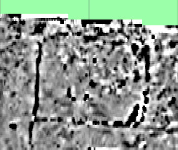
(3) Edlington, Cottage Field, Holme Hall Quarry (SK 54694 96418): an archaeological strip, map and sample excavation was undertaken prior to mineral extraction on a site where prior geophysical survey had identified an L-shaped ditched anomaly thought to form part of a square or rectangular enclosure with its sides approximately 40 m in length ( fig. 13). Fieldwalking over the site produced a small assemblage of Romano-British pottery clustered within and around the enclosure, with excavation demonstrating that the enclosure consisted of a substantial ditch cut into the subsoil and/or the Magnesian limestone bedrock. Additional ditches, pits and post-holes were also identified within the enclosed area. Systematic excavation revealed the enclosure to be Romano-British in date and to have at least two main structural phases. The ceramic assemblage comprises a few thousand sherds of pottery, mostly of local types, making this one of the largest, if not the largest, Romano-British ceramic assemblage from South Yorkshire. Two beehive quernstones were also recovered, together with charred wood and plant remains and one unidentifiable coin. A human cremation with an associated Romano-British vessel was found immediately outside the enclosure in a small, heavily truncated pit. Elsewhere within the excavation area a discontinuous linear ditch was investigated, which although not directly dated, produced sherds of Romano-British pottery, including samian, from its upper fill.Footnote 95
Holme Hall Quarry, Edlington. Geophysical plot of the Romano-British enclosure.

LANCASHIRE
(1) Ribchester to Catterall: the search for a road between Ribchester and Lancaster has been ongoing for over 150 years. The existence of a village, farm and bridge called Street, close to a direct line, only increased speculation. Margary included this road as his number 704 but he cautioned that its route was, in part, ‘uncertain’.Footnote 96
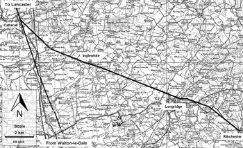
Lidar does not lend any support for Margary 704, but what it does reveal is a previously unknown route heading to Catterall, where it joins the recently discovered route of the Roman road from Walton-le-Dale to Lancaster ( fig. 14).Footnote 97
The route of the road from Ribchester to Catterall.

The first alignment from Ribchester initially follows Longridge Road but where Margary 704 was thought to turn off it carries straight on. It crosses Fleet Street Lane just to the east of Setters Cottage (SD 6306 3688) and changes alignment about 185 m beyond there at approximately SD 629 370. It makes a small turn towards Longridge, heading for a much more sensible place to cross the ridge of Longridge Fell than the OS First Edition portrayed.
This second alignment passes under Stonelands Farm and the agger, both before Stonelands and after, has survived remarkably intact. Approaching Stonelands, an old field boundary that crossed the agger at right angles has been removed revealing the cross-section of the road to be approximately 7–8 m in width and 0.5 m in depth (SD 6261 3707–SD 6245 3712). At Stonelands there is a known Roman milestone.Footnote 98 Its provenance is uncertain having been moved and re-erected. However, if it were from another Roman road, as postulated,Footnote 99 then this would have involved a move of at least 2 miles. If it has been moved from this road, then that would represent a move of probably less than 100 m. Given the size of the milestone, this seems more likely.
The route does not become evident again in the Lidar data until crossing the fields at Dilworth. It begins a new short alignment at SD 6131 3754 to ease the gradient of the climb by cleverly angling across the slope — typical Roman engineering. It is aiming for what is now the junction of Higher Road and Green Lane at SD 6095 3753.
From Green Lane the main alignment begins by heading in the direction of Inglewhite Road/Alston Arms and continues all the way to the river Brock. The onward sighting point from Green Lane is likely to have been the high ground west of Inglewhite around Bourne Brow and thence down to the river Brock crossing.
The Lidar coverage runs out for a spell near Kidsnape Farm but fortunately there is documentary evidence confirming the road here. A document dating to c. a.d. 1200 describes the land boundaries of the farm, which were then bounded on one side by ‘the old causeway’.Footnote 100
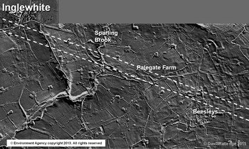
The Lidar data resume for around 2 km approaching Inglewhite. This reveals very clear evidence for the agger showing that the road has survived extremely well here ( fig. 15). It also indicates a very slight change of direction at Palegate Farm (SD 5562 3962). Between Palegate Farm and Inglewhite the remains of the west bridge abutment at Sparling Brook have survived as a prominent swell in the ground (SD 5534 3972). To the west of this abutment the road is first in a shallow cutting and then continues as a normal agger towards the modern road in the direction of Inglewhite.
Ribchester to Catterall Roman road. Lidar image of the section approaching Inglewhite. (© The Environment Agency)

Through Inglewhite, the modern road in front of The Barn on the Green (SD 5467 3995) marks the course. Beyond Inglewhite there is another gap in the Lidar coverage but there is little reason for the road to have deviated off the straight alignment for which Lidar evidence resumes approaching the river Brock by the side of Lydiate Lane (SD 5255 4075).
Unusually, the river Brock crossing point marks a change of direction. On the north bank, opposite Trout Row Cottages, a cutting leads down to the likely crossing point (SD 5210 4098). The height of the cutting would match a bridge abutment rather than a ford. This was to be expected as the Brock is often subject to rapid increases in depth with run-off from the Bowland Fells so fording would have been unpredictable.
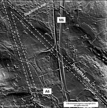
Beyond the river Brock, on the final alignment, the agger is visible on the ground crossing the fields of Matshead Farm, off Lydiate Lane (SD 5200 4107–5190 4117). Where the Roman road crosses the track to Matshead Farm, there is a very distinct rise to get over the agger. For around 0.5 km Ducketts Lane then overlies the Roman road (SD 5160 4147). Beyond Ducketts Lane, the motorway, railway and canal all cut through the road alignment. Beyond the canal faint traces re-appear and Lidar shows the agger again either side of Stubbins Lane (SD 5043 4265) ( fig. 16).
Ribchester to Catterall Roman road. Lidar image in the vicinity of the junction with the main north–south Roman road at Catterall. (© The Environment Agency)

The actual junction with the north–south road from Walton-le-Dale does not show up clearly on the Lidar coverage.Footnote 101
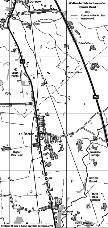
(2) Barton, Walton-le-Dale–Lancaster Roman road: it was previously reported that Lidar had enabled the route of this road to be established south of Garstang.Footnote 102 Further Lidar studies have extended this southwards from Bilsborrow as far as Dean Brook, Barton ( fig. 17). The ‘chicane’ south of Bilsborrow (SD 5133 3923) at first looks unlikely but actually is very sensible Roman engineering — moving off line to negotiate a slope/valley but then returning to the same alignment (SD 5142 3908). This alignment is visible, albeit faintly, at Jepps Lane (SD 5197 3762), heading for a crossing of Barton Brook at SD 5233 3668. On the south side of this brook, a slightly different alignment begins at SD 5244 3652 and heads for a crossing of Dean Brook at SD 5258 3603.
Walton-le-Dale to Lancaster Roman road. Map showing the course of the road revealed by Lidar between Bilsborrow and Barton. (© Ordnance Survey)

South of Dean Brook traces are much less obvious but a sighting point in the vicinity of Banister Hill, Durton Lane seems likely. This would indicate a possible crossing of Blundel Brook at SD 5316 3461. Towards Fulwood and Preston then modern development makes determining the line somewhat speculative, However, a continuing straight course towards Preston is probably as good as can be surmised and this would cross Savick Brook around SD 5381 3198.Footnote 103
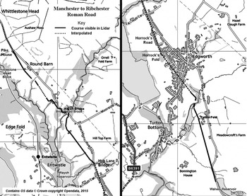
(3) Edgworth, Roman road Manchester–Ribchester: the course of this road (Margary 7b) is well established and GIS analysis has been used to show that it comprised four main alignments.Footnote 104 However, in the case of the second from Affetside to Rushton's Height, the route is poorly known with several gaps around Edgworth. Current Ordnance Survey (OS) maps record short sections of the road in three disparate locations. Lidar has revealed that two of these are correct (but not the third) and has enabled the route to be completed with reasonable confidence ( fig. 18).
Manchester to Ribchester Roman road; map of the Edgworth section. (© Ordnance Survey)

The first OS recorded section is towards Pelton Fold and ends at SD 7429 1604. Lidar shows this clearly and extends it onwards, angling down to a crossing point of Quarlton Brook at SD 7425 1628, close to a modern footbridge. On the north bank, the agger reappears on the Lidar data (SD 7421 1642) and this new section is now heading in the general direction of Horrock's Fold and Horrock's Road. This would fit with the next piece of Lidar evidence north of Edgworth. This indicates that Hob Lane Bridge on Blackburn Road represents the Roman line. The first stretch of modern road heading south from this bridge also points towards Horrock's Road and Horrock's Fold. With all the modern development of Edgworth, the Horrock's Fold/Road course can only be regarded as probable rather than certain.
Modern OS maps next show a short piece of Roman road to the rear (west) of Crooked Walls (SD 7325 1803). Again Lidar confirms this as correct and extends it in both directions. Southwards it is visible to Hob Lane Bridge as already alluded to. Northwards, it continues to just beyond Green Alders (SD 7312 1821). Here begins a series of zigzags to negotiate the valleys of Broadhead Brook and an unnamed brook emanating from near Wayoh Barn. The crossing of the former (just east of Wayoh Bridge) is at SD 7315 1840 and the latter at SD 7292 1858.
The third section shown on modern OS maps coincides with Blackburn Road beyond Wayoh Bridge near Round Barn. However, Lidar indicates that the line is actually further west in the fields (SD 7253 1901). Part of this section has apparently been removed by a landslip down towards Whittlestone Head Brook. It finally angles slightly to rejoin the modern road at Pike House (SD 7238 1927) and onto the accepted route north.Footnote 105
(4) Edgworth, Wayoh Bridge (SD 7324 1817): whilst investigating gaps in the course of the Manchester to Ribchester Roman road (Margary 7b), the outline of a possible Roman fort was noted north of Edgworth. The site had been recorded previously and was suggested to be Coccium.Footnote 106 Lidar has shown ( fig. 19) the possible outline of a small fort with double ditches on two, perhaps three, sides. The ‘fort’ platform measures approximately 80 by 60 m and its location on a headland before the descent to Wayoh Bridge is an excellent one. This site is approximately 14 miles from Manchester and 12 miles from Ribchester making it a logical location and the PastScape record makes a similar point. However it is unlikely to be Coccium as this name is now generally assumed to apply to Wigan.Footnote 107
Lidar image showing the route of road Margary 7b and the earthworks of the possible Roman fort near Wayoh Bridge. (© The Environment Agency)

CHESHIRE
(1) Sandbach, Congleton Road (SJ 7602 3614): a metal-detector survey was undertaken ahead of a housing development.Footnote 108 This produced a range of finds of Roman, medieval and Civil War date. The Roman (and medieval) finds were recovered from the west side of the site, and included three very damaged Roman coins (including one sestertius), the arm of a bronze figurine, a cast copper-alloy rivet and a lead weight. The recovery of Roman finds was considered to have particular archaeological significance, as there was previously very little recorded Roman activity in or around Sandbach, which is believed to have origins in the Saxon period.
A watching-brief was subsequently undertaken over 1.3 ha of land on the west side of the site, which recorded the presence of previously unknown Romano-British remains. The excavated evidence indicated the presence of part of a field-system and agricultural activity associated with a nearby farmstead. A series of linear enclosure ditches and the possible remains of a sheep race were investigated, which indicated a local economy involving animal husbandry. The ditches defined a series of rectilinear enclosures, the largest recorded ditch being 1.9 m wide and 0.45 m deep. Charred cereal grain was recovered from five soil samples, and consisted of an oat species, as well as hexaploid bread-wheat-type grains and indeterminate charred types. The heavy charring on this material did not allow a more detailed identification, though remains of this nature would be consistent with the species which would be expected in low numbers on a site near a Romano-British settlement. A small assemblage of Roman pottery, including some samian pottery, ceramic building material and rotary quern fragments were recovered from the enclosure ditches, spanning the second to third centuries a.d. The relatively low number of finds also indicated that the main focus of settlement was elsewhere.Footnote 109
LINCOLNSHIRE
(1) Near Grantham, Mill Farm solar farm (SK 9493 3121): eight evaluation trenches were excavated across approximately 15 ha, targeting anomalies that had been detected by an earlier geophysical survey. The site contains an unenclosed farmstead dating from the late Iron Age to the early/mid-Roman period, consisting of up to five large-diameter (13 m to 21 m diameter) ring-gullies and a group of linear and curvilinear ditches. It is thought that the ring-gullies probably drained the sites of former roundhouses (of which no direct traces were apparent), with the other ditches representing a sequence of agricultural enclosures, probably related to stock-handling. The layout of the site probably changed incrementally, with some occasional more radical re-organisation. The farmstead lay within a well-established open landscape comprising grassland and arable fields. The finds assemblage is of modest size with mostly utilitarian items in a limited range of materials. The animal bone assemblage is relatively small and dominated by remains of cattle. Overall, the remains are fairly typical for the period and region, although the large diameter of the ring-gullies is unusual.Footnote 110
(2) Witham St Hughs, Sheep Wash Farm (SK 8950 6300): a trial-trench evaluation within former RAF Swinderby revealed a complex of Roman settlement-related features focused on the central southern portion of the site around a series of rectangular enclosures forming a ‘ladder’ settlement, previously identified by a geophysical survey.Footnote 111 This settlement mainly comprised boundary and drainage ditches, although some discrete rubbish pits were also present. These features were associated with moderate quantities of finds including quernstones, animal bone, pottery of predominantly mid- to later Roman date and ceramic building material, suggesting the presence of relatively substantial settlement in the vicinity of the trenches. The focus of settlement appeared to be to the south-east, where the posited enclosures and other features were more prevalent, and exhibited a greater range of forms. To the south-west, the ditches were more limited in number, consisting of large, steep-sided examples which formed relatively regular square enclosures. The features of this area indicated a near settlement, infield function for this part of the site, something that is also suggested by the presence of an adult inhumation just outside the bounds of one of the enclosures. The site also revealed a mid- to late Iron Age roundhouse and associated features.Footnote 112