1. Introduction
Over the last two decades, salt tectonics have received growing interest from within the research community and countless studies have provided a sound basic understanding of the role which salt plays in orogen and passive margin evolution (Wu, Bally & Cramez, Reference Wu, Bally and Cramez1990; Diegel et al. Reference Diegel, Karlo, Schuster, Shoup, Tauvers, Jackson, Roberts and Snelson1995; Fletcher, Hudec & Watson, Reference Fletcher, Hudec, Watson, Jackson, Roberts and Snelson1995; Jackson, Reference Jackson, Jackson, Roberts and Snelson1995; Letouzey et al. Reference Letouzey, Coletta, Vially, Chermette, Jackson, Roberts and Snelson1995; Vila, Reference Vila1995; Alsop, Reference Alsop, Alsop, Blundell and Davison1996; Koyi, Reference Koyi, Alsop, Blundell and Davison1996, Reference Koyi1998; Guglielmo, Jackson & Vendeville, Reference Guglielmo, Jackson and Vendeville1997; Talbot, Reference Talbot, Blundell and Scott1998; McBride, Reference McBride and Hurley1998; McBride, Rowan & Weimer, Reference McBride and Hurley1998; Al-Zoubi & Brink, Reference Al-Zoubi and Brink2001; Barde et al. Reference Barde, Gralla, Harwijanto and Marsky2002; Vila et al. Reference Vila, Ghanmi, Ben Youssef and Jouirou2002; Rowan et al. Reference Rowan, Lawton, Giles and Ratliff2003; Maillard et al. Reference Maillard, Gaullier, Vendeville and Odonne2003; Talbot & Aftabi, Reference Talbot and Aftabi2004; Canérot, Hudec & Rockenbauch, Reference Canérot, Hudec and Rockenbauch2005; Gaullier & Vendeville, Reference Gaullier and Vendeville2005; Vendeville, Reference Vendeville2005; Hudec & Jackson, Reference Hudec and Jackson2006; Jackson & Harrison, Reference Jackson and Harrison2006; Hudec & Jackson, Reference Hudec and Jackson2007, Reference Hudec and Jackson2009; Mohr et al. Reference Mohr, Warren, Kukla, Urai and Irmen2007; Talbot & Pohjola, Reference Talbot and Pohjola2009). In passive margins, where most of the world's salt structures are located, salt movement is related to various factors under diverse geological conditions. Differential loading and buoyancy have been acknowledged as the main factors controlling salt movement (Hudec & Jackson, Reference Hudec and Jackson2006). However, other factors are described in the literature such as: gravity spreading halokinesis, thermal convective halokinesis (Jackson & Talbot, Reference Jackson and Talbot1986), tectonic extension (thin or thick-skinned) of the overburden and/or basement (Koyi, Reference Koyi1991; Vendeville & Jackson, Reference Vendeville and Jackson1992a , b; Koyi, Jenyon & Petersen, Reference Koyi, Jenyon and Petersen1993; Koyi & Petersen, Reference Koyi and Petersen1993; McClay & Dooley, Reference McClay and Dooly1996; Davison et al. Reference Davison, Alsop, Evans and Saafricz2000; Schlische, Withjack & Eisenstadt, Reference Schlische, Withjack and Eisenstadt2002; Pilcher, Kilsdonk & Trude, Reference Pilcher, Kilsdonk and Trude2011). Recent works (Brun & Fort, Reference Brun and Fort2011; Fort & Brun, Reference Fort, Brun, Alsop, Archer, Hartley, Grant and Hodgkinson2012) recognized the dominant gliding process as the main mechanism of salt tectonics at a passive margin. This mechanism is primarily due to the margin tilt (Brun & Fort, Reference Brun and Fort2011). Rowan et al. (Reference Rowan, Peel, Vendeville and Gaullier2012) also identified gravity spreading as a dominant process of passive margin salt tectonics. In this context, different categories of salt structure are described at passive margins, such as: salt dome or diapir; salt anticline; salt wall; salt pillow; salt glacier; salt sheet. The literature presents a varied vocabulary of domains and provinces such as: allochthonous salt bodies (Lehner, Reference Lehner1969); allochthonous salt tongues (Watkins et al. Reference Watkins, Worzel, Houston, Ewing and Sinton1975); salt lobes (Buffler & Worzel, Reference Buffler and Worzel1978); salt sheets (Humphris, Reference Humphris, Bouma, Moore and Coleman1978); salt glaciers (Martin, Reference Martin, Bouma, Moore and Coleman1978, Vila et al. Reference Vila, Ghanmi, Ben Youssef and Jouirou2002); canopy like-complexes (Talbot & Jackson, Reference Talbot and Jackson1987); advanced salt tongues and detached allochthonous salt sheets (Wu, Bally & Cramez, Reference Wu, Bally and Cramez1990); composite salt canopies and lobate-fronted salt-canopies (Jackson, Vendeville & Schultz-Ela, Reference Jackson, Vendeville and Schultz-Ela1994); salt-tongue canopies (Rowan et al. Reference Rowan, Ratliff, Trudgill and Duarte2001; Vila et al. Reference Vila, Ghanmi, Ben Youssef and Jouirou2002).
Salt sheets are abundant in deep water basins and are relatively well studied and documented in passive margins (Worral & Snelson, Reference Worral, Snelson, Bally and Palmer1989; Seni, Reference Seni1992; Jackson, Reference Jackson, Jackson, Roberts and Snelson1995; Hudec & Jackson, Reference Hudec and Jackson2006; Talbot & Pohjola, Reference Talbot and Pohjola2009). Hudec & Jackson (Reference Hudec and Jackson2006) proposed that allochthonous salt sheets move forward in four ways: extrusive advance, open-toed advance, thrust advance, and salt-wing intrusion.
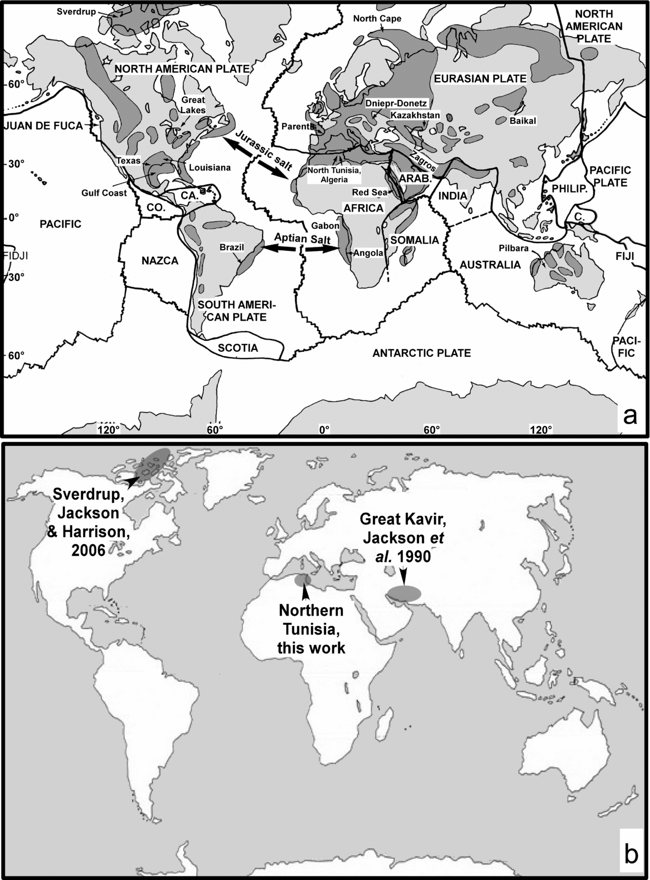
The first salt canopy presented in the literature is from the Salina basin in Mexico and was described, by Correa Perez & Gutierrez y Acosta (Reference Correa Perez and Gutierrez y Acosta1983). Salt canopies have been studied by numerous researchers mainly in subsurface using drilling and 2D or 3D seismic data (Seni, Reference Seni1992; Diegel et al. Reference Diegel, Karlo, Schuster, Shoup, Tauvers, Jackson, Roberts and Snelson1995; Heaton, Jackson & Bamahmoud, Reference Heaton, Jackson, Bamahmoud, Jackson, Roberts and Snelson1995; Rowan, Reference Rowan, Jackson, Roberts and Snelson1995, Reference Rowan2002; Schuster, Reference Schuster, Jackson, Roberts and Snelson1995; Prather et al. Reference Prather, Booth, Steffens and Craig1998; Beaubouef & Friedmann, Reference Beaubouef, Friedmann, Weimer, Slatt, Coleman, Rosen, Nelson, Bouma, Styzen and Lawrence2000; Hudec & Jackson, Reference Hudec and Jackson2006, Reference Hudec and Jackson2007, Reference Hudec and Jackson2009). This rare salt category is defined as a ‘salt structure formed by coalescence of multiple allochthonous salt sheets emanating from multiple feeders’ (Jackson, Reference Jackson, Jackson, Roberts and Snelson1995). The variety of these salt structures was not described until 1980s. This canopy is a laterally intrusive sheet of salt coalesced from two or more feeders. Until now, only two such structures have been described in outcrop: Jackson et al. (Reference Jackson, Cornelius, Craig, Gansser, Stocklin and Talbot1990) presented the first outcropping salt canopy in the Great Kavir of the northern Iran, which results from the coalescence of 12 salt domes. In 2006, the second example from Axel Heiberg Island, Sverdrup Basin, Canada was presented by Jackson & Harrison (Reference Jackson and Harrison2006).
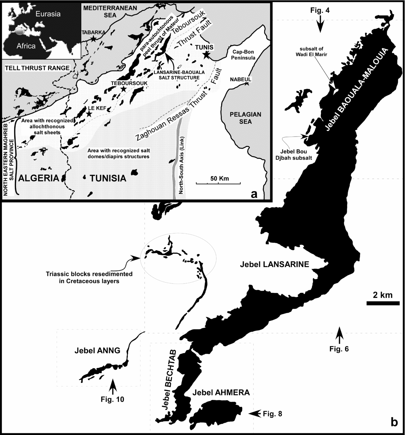
This paper presents the third example of an outcropping salt canopy, from northern Tunisia, on the North African continental margin. The Lansarine–Baouala salt structure (LBSS; Fig. 1) consists of allochthonous sheets of Triassic salt that extruded and coalesced in Cretaceous times. Extrusion of such salt sheets is associated with extensional Cretaceous faulting (probably both in the cover and basement) from many feeders. Recognizing the rarity of a salt canopy, we detail the geometric relationships between the Triassic salt of the LBSS and the surrounding Mesozoic and Cenozoic rocks on geological maps and cross sections. For salt position, we use detailed micropalaeontological data to establish stratigraphic polarity in the key sectors (Figs 2, 3). We also describe sedimentological features to characterize the significant facial appearance and salt contacts. We combine our field results (Figs 4–12) with gravimetric data (Figs 14, 15) and a seismic profile (Fig. 16). Finally, we propose conclusions from regional and global points of view (Figs 13, 18, 19).
General location.(a) Location of the Atlas system in the Mediterranean zone; map of outcrop salt structures in northern Tunisia and northeastern Algeria: northeastern Maghreb Salt Province; (b) general structural trend map of salt outcrop distribution of the Lansarine–Baouala salt structure and locations of detailed geological maps (Figs 4, 6, 8, 10).

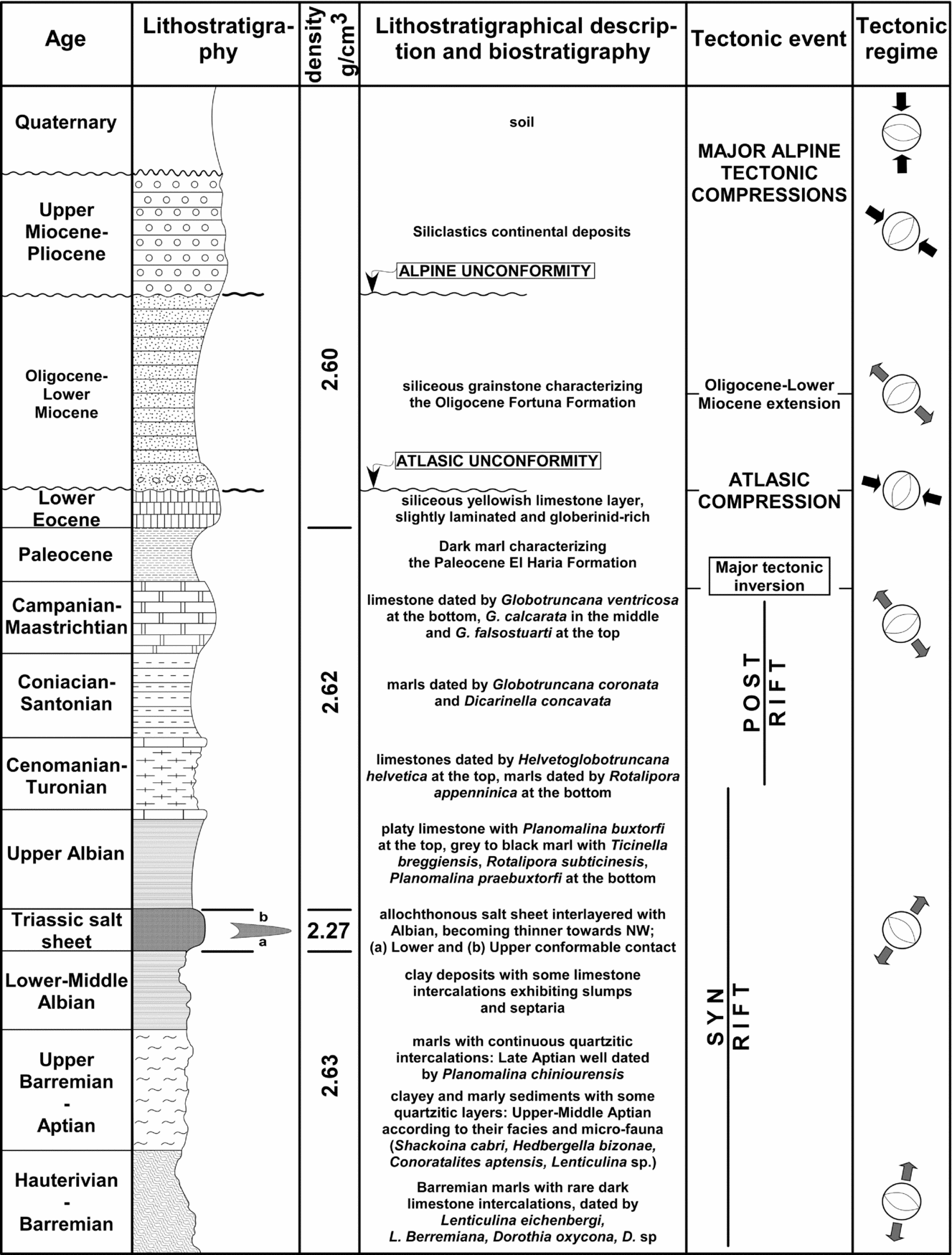
Composite lithostratigraphical subdivisions, bulk densities of sediments in the study area, summary of biostratigraphy, and regional tectonic events. See text for detailed description of fauna.

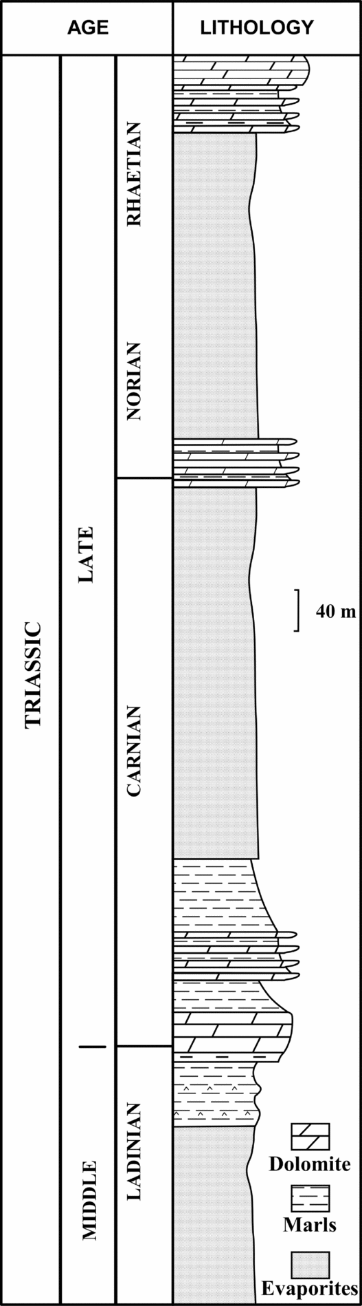
Lithostratigraphical section of the Triassic series cropping out in Jebel Rheouis, Central Tunisia, after Soussi et al. (Reference Soussi, Cirilli and Abbes2001).

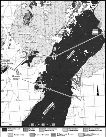
Detailed geological map of Jebel Baouala (north portion of the LBSS). White – Quaternary; thin, dashed lines – hydrography; bold lines – faults.

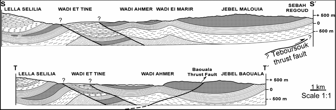
Geological cross sections of Jebel Baouala prepared from surface data. See Figure 4 for locations of sections and legend.

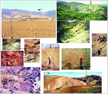
Geometry and nature of the LBSS salt emplacement. (a) Panoramic view of the central part of the Lansarine region showing the Triassic salt on the middle Albian series, the contact is enhanced by white dashed line. Note that Triassic salt reposes on a single marly layer and does not cut different strata. (b) The lower contact at Aïn el Kerma exhibiting its conformable character; hammer for scale circled. (c) The lower contact at Aïn el Kerma showing a planar organization of Triassic salt over a rich-glauconitic ‘conformable’ contact. (d) Lansarine, Middle Albian marl with calcareous nodules attesting to sedimentation over a sub-marine slope. (e) Different sized Triassic blocks (arrowed), north Jebel Boulahouadjeb. (f) Panoramic view looking to the north of the Wadi el Marir anticline showing Aptian marls supporting Triassic salt and the pericline closure testifying to the Triassic salt position on the Aptian series. (g) View looking to the northwest of the lower contact (white dashed line) showing NW-dipping Albian marls and Limestones plunging under the chaotic Triassic material; Wadi Maïou. (h) Detail of the lower contact in Wadi Maïou showing its ‘sedimentary’ character with conglomerates of Triassic insoluble elements. (i) View looking northeastward showing the Atlasic (Pyrenean) unconformity. Photo exhibits 45° NW-dipping Oligo-Miocene strata (O-M) unconformably covering a 65° NW-dipping Upper Cretaceous (C) strata. (j) View looking eastward from the south of Jebel Bechtab illustrating the Triassic salt interbedded between two continuous Cretaceous sequences with the currently active strike-slip fault shown in red. (k) Detail of exposed fault plane indicating early normal displacement followed by a strike-slip movement.

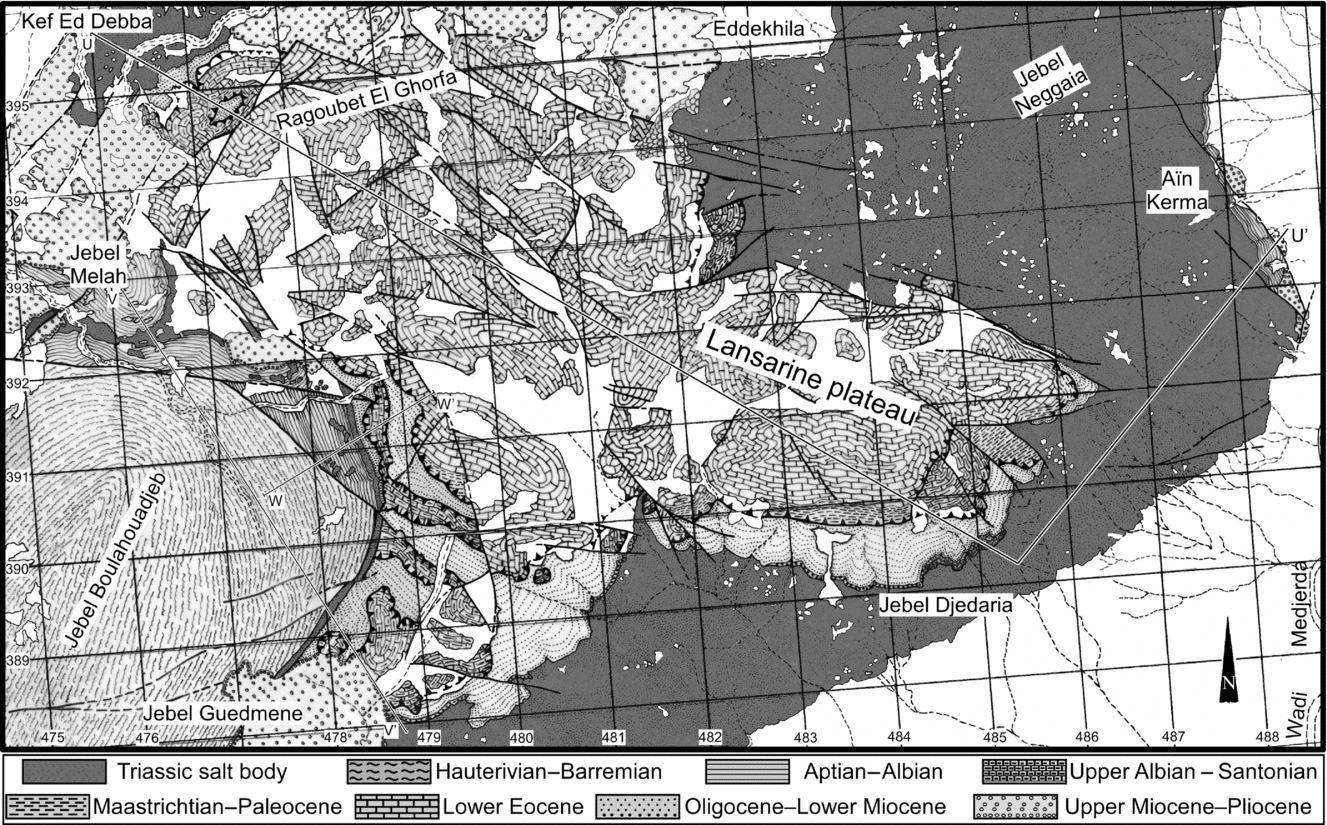
Detailed geological map of Jebel Lansarine (central portion of the LBSS). See Figure 2 for legend.

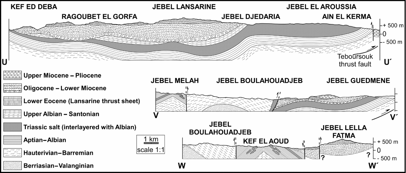
Geological cross sections of Jebel Lansarine prepared from surface data. See Figure 7 for locations of sections and legend. TTF – Teboursouk Thrust Fault.

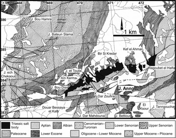
Detailed geological map of Jebel Anng (southwestern portion of the LBSS). See Figure 2 for legend.

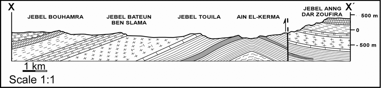
Geological cross section of Jebel Anng prepared from surface data. See Figure 9 for location of section and legend.

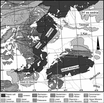
Detailed geological map of Jebel Bechtab and Jebel Ahmera (south portion of the LBSS). See Figure 2 for legend.

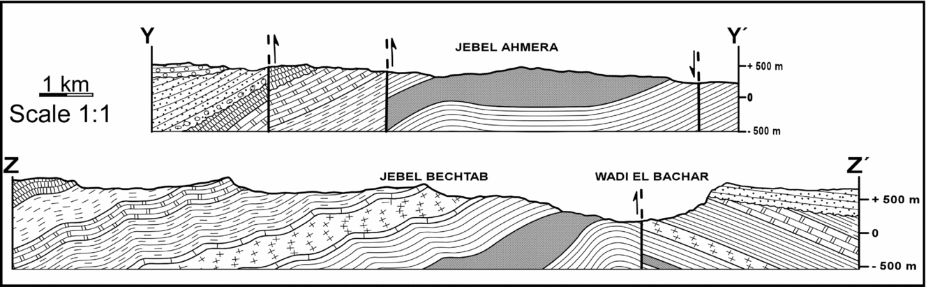
Geological cross sections of Jebel Bechtab-Ahmera prepared from surface data. See Figure 11 for locations of sections and legend.

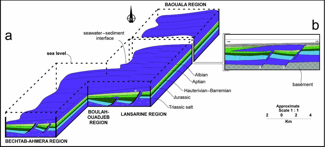
(a) 3-D block diagram illustrating the main structural features associated with Cretaceous extension and the rise of Triassic salt along the NE–SW normal faults. The downslope sheets of allochthonous salt appear to have been earlier (Aptian) than upslope (Albian) sheets. (b) Simplified stage reconstruction (not to scale) of tectono-sedimentary evolution of the northern LBSS. Note that this schematic section is not intended to show the mode of triggering mechanism of the initial salt extrusion.

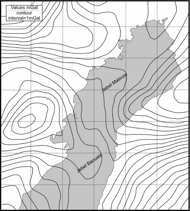
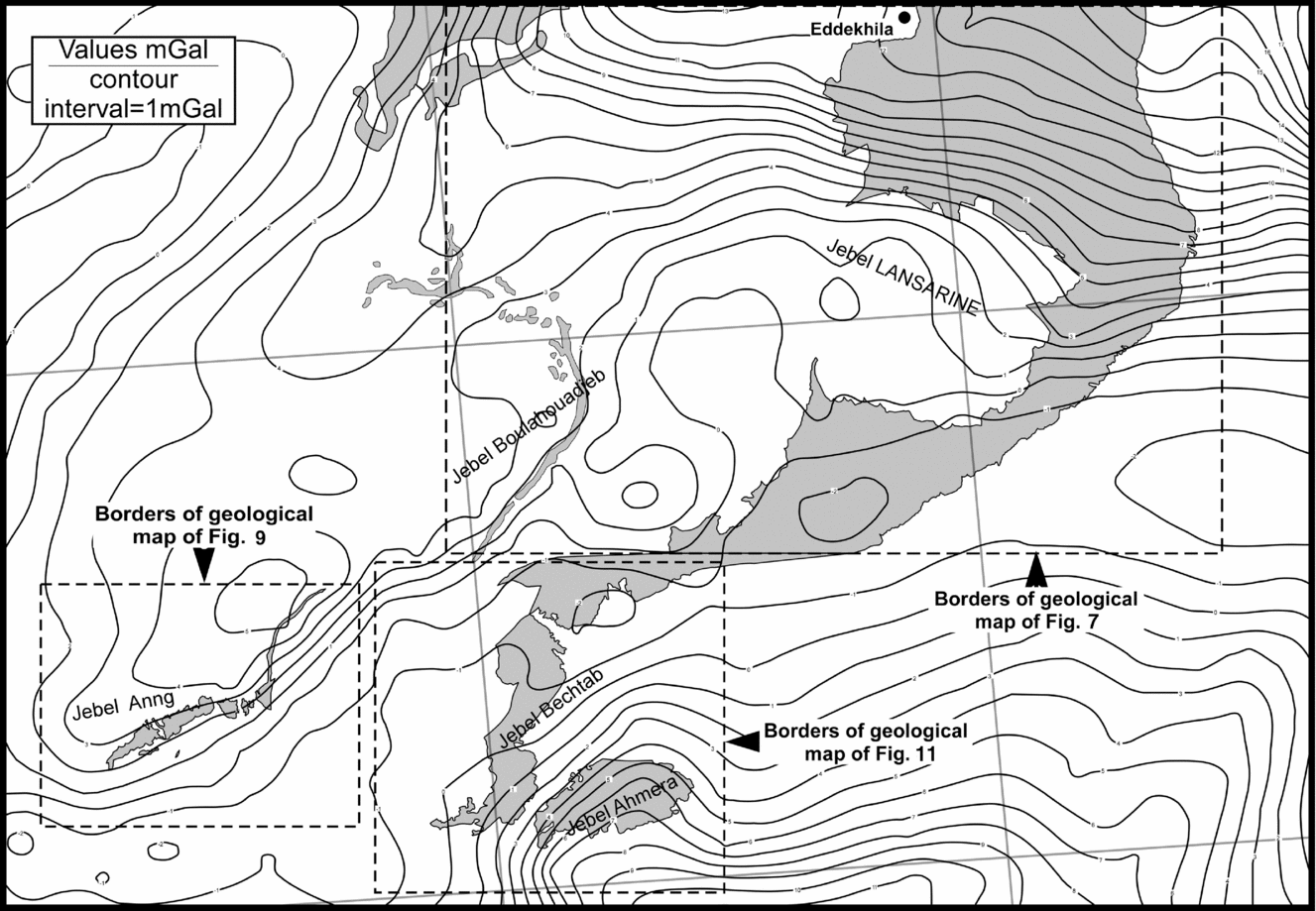
Bouguer gravity map of the northern portion of the LBSS, with the Triassic salt outcrop superimposed. The contour interval is 1mGal; see Figure 4 for geological detail.

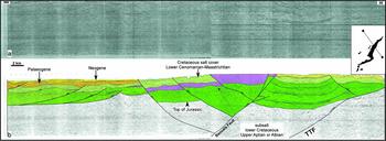
NW–SE seismic-reflection line from Mateur to Tébourba town, crosses the LBSS in its northern portion. (a) Non-interpreted copy; (b) interpreted copy, slightly modified from Rigo et al. (Reference Rigo, Garde, El Euch, Bandt and Tiffert1996). TTF – Teboursouk Thrust Fault.

2. Geological framework of northern Tunisia
Northern Tunisia is near the northwestern edge of the African plate. It represents the eastern part of the Atlas System (Morocco, Algeria and Tunisia). The Atlas fold-thrust belt is part of the alpine chain of Africa, extending about 2000 km from the oriental coast of Tunisia to the Atlantic coast of Morocco (Fig. 1), and related to the collision of the African and European plates in Tertiary time. The Meso–Cenozoic tectono-sedimentary history of northern Tunisia is divided into two major periods (Fig. 2). The first one, from the late Permian to the early Cretaceous, corresponds to an extensional tectonic period related to Mesozoic rifting. This latter was associated with the opening of the Tethyan and Central Atlantic oceans in Mesozoic times, followed by passive margin basin tectonics up to late Cretaceous times. Early Mesozoic rifting formed a Triassic basin that was dominated by salt deposits covering all Tunisia (Kamoun et al. Reference Kamoun, Peybernes, Ciszak and Calzada2001). In the southwestern part of the Tethys Ocean, this margin was characterized by extension, crustal thinning and subsidence. The Triassic series consists of a thick continental salt, evaporites, clays, and dolomites deposited within an epicontinental environment (Fig. 3). In some localities, basaltic rocks testify to the rifting stage. In Jurassic times, sedimentation in Tunisia mainly comprised carbonate deposits in the southern part of the Tethyan Ocean. The Cretaceous corresponds to palaeogeographic differentiation with a platform in central-southern Tunisia contemporaneous with a pelagic basin (Tunisian trough) in the north. During early Cretaceous times, this trough received thick siliciclastic sediments and carbonate deposits, and in late Cretaceous times, interbedded open marine shale and shallow marine carbonate sediments.
After the Mesozoic extensional period, a Cenozoic compressional cycle occurred, in which tectonic inversion began in the transition from the Lower Senonian to the Upper Senonian (Guiraud et al. Reference Guiraud, Bosworth, Thierry and Delplanque2005; Masrouhi et al. Reference Masrouhi, Ghanmi, Ben Youssef, Vila and Zargouni2007, Reference Masrouhi, Ghanmi, Ben Slama, Ben Youssef, Vila and Zargouni2008) and compression continued up to the present. This second, Cenozoic, period is characterized by compressive tectonic episodes intercalated with periods of relative tectonic quiescence (Guiraud et al. Reference Guiraud, Bosworth, Thierry and Delplanque2005; Masrouhi et al. Reference Masrouhi, Ghanmi, Ben Youssef, Vila and Zargouni2007, Reference Masrouhi, Ghanmi, Ben Slama, Ben Youssef, Vila and Zargouni2008; Frizon de Lamotte et al. Reference Frizon de Lamotte, Leturmy, Missenard, Khomsi, Ruiz, Saddiqi, Guillocheau and Michard2009) related to the collision of the African and European plates in Cenozoic time.
Considerable debate remains regarding tectonic deformation style and the timing of Cenozoic compressional events. Essentially, two models are proposed: the first one is a thin-skinned model in which variation of facies plays an important role in detachment, especially on Triassic evaporitic layers (Outtani et al. Reference Outtani, Addoum, Mercier, Frizon de Lamotte and Andrieux1995; Ahmadi et al. Reference Ahmadi, Ouali, Mercier, Mansy, Van-Vliet Lanoe, Launeau, Rhekhiss and Rafini2006). The second, thick/thin skinned model, recognizes the importance of reactivation of an inherited major fault (Souquet et al. Reference Souquet, Peybernes, Saadi, Ben Youssef, Ghanmi, Zarbout, Chikhaoui and KAmoun1997; Morgan, Grocott & Moody, Reference Morgan, Grocott, Moody, Macgreggor, Moody and Clark-Lowes1998; Riley et al. Reference Riley, Gordon, Simo, Tikoff and Soussi2011; Masrouhi & Koyi, Reference Masrouhi, Koyi, Alsop, Archer, Hartley, Grant and Hodgkinson2012). Two different models for the timing of Cenozoic compressional events have also been suggested. The first one proposes that inversion occurred in middle–early Miocene time and that the margin extended during Mesozoic and Palaeogene times (Ahmadi et al. Reference Ahmadi, Ouali, Mercier, Mansy, Van-Vliet Lanoe, Launeau, Rhekhiss and Rafini2006). The second model proposes that inversion occurred at the transition from the Cretaceous to the Palaeogene and recognizes a first compressive event in Eocene time (Guiraud & Bosworth, Reference Guiraud and Bosworth1997; Frizon de Lamotte et al. Reference Frizon de Lamotte, Crespo-Blanc, Saint-Bezar, Comas, Fernandez, Zeyen, Ayarza, Robert-Charrue, Chalouan, Zizi, Teixell, Arboleya, Alvarez-Lobato, Julivert, Michard, Cavazza, Roure, Spakman, Stampfli and Ziegler2004, Reference Frizon de Lamotte, Leturmy, Missenard, Khomsi, Ruiz, Saddiqi, Guillocheau and Michard2009; Masrouhi et al. Reference Masrouhi, Ghanmi, Ben Youssef, Vila and Zargouni2007, Reference Masrouhi, Ghanmi, Ben Slama, Ben Youssef, Vila and Zargouni2008; Melki et al. Reference Melki, Zouaghi, Harrab, Casas Sainz, Bédir and Zargouni2011) and compression continuing to the present. The second tectonic event in Tunisia is a paroxysmal Miocene (Tortonian) event with a NW–SE main regional compression direction. This compression induced the formation of NE-trending folds and thrusts named, by authors in Eastern Maghreb, the Atlasic direction (NE–SW). Most of the structures resulting from this phase in northern Tunisia are SE-vergent folds and thrusts belts.
The Alpine range in Tunisia is located in the north Zaghouan structural belt, also named the Zaghouan-Ressas Thrust Fault. The present Zaghouan Thrust Fault corresponds in Mesozoic time to a palaeogeographic line between a southern platform region and a deep trough in the north. The present NE-trending structural zone in northern Tunisia is approximately 150 km between the Zaghouan ridge and the North Tunisian Mediterranean shore (Fig. 1). This zone can be divided into two domains: (1) The Tell thrust range in the north, composed of thrust sheets transported during Middle Miocene; (2) the north Tunisian Atlas in the south-east, itself usually divided also into two main tectonic units: (a) in the south, the Zaghouan unit marks the front of the Atlasic Alpine Range; (b) the Teboursouk unit, which is located in the Tunisian part of the northeastern Maghreb Salt Province, is characterized by numerous outcropping salt structures and a so-called diapir zone (Perthuisot, Reference Perthuisot1978; Perthuisot, Rouvier & Smati, Reference Perthuisot, Rouvier and Smati1998). Due to the local occurrence of Triassic evaporites resedimented in the Cretaceous sequence, this zone is regarded as a submarine salt glacier zone (Vila, Reference Vila1995; Ghanmi et al. Reference Ghanmi, Ben Youssef, Jouirou, Zargouni and Vila2001; Vila et al. Reference Vila, Ghanmi, Ben Youssef and Jouirou2002; Masrouhi & Koyi, Reference Masrouhi, Koyi, Alsop, Archer, Hartley, Grant and Hodgkinson2012).
As at many passive margins, in the North African margin, salt-related structures are dominant features. Salt structures in North Africa expose Triassic salt (200–250 Ma). In Mesozoic times, North Africa (south margin of Tethys Ocean) was an extensional margin showing salt movement. In the eastern part of the Atlas system (northeastern Algeria and northern Tunisia, which we name the Northeastern Maghreb Salt Province), there are numerous outcropping salt bodies. In northern Tunisia there are numerous outcrops of Triassic salt structures (with a NE–SW prevailing strike), which range in size from few metres to few hundred square kilometres (Fig. 1). The mechanism of salt emplacement is still a matter of debate and two models have been proposed: (1) a diapir or dome model (Perthuisot, Reference Perthuisot1978; Perthuisot, Rouvier & Smati, Reference Perthuisot, Rouvier and Smati1998; Jallouli et al. Reference Jallouli, Chikhaoui, Brahem, Turki, Mickus and Benassi2005; Benassi et al. Reference Benassi, Jallouli, Hammami and Turki2006), describing a scenario where the salt actively pierced the overburden and tectonically reduced the thickness of the overburden sequences in the limbs of the structure; and (2) a ‘salt glacier’ model (Vila et al. Reference Vila, Ben Youssef, Chikhaoui and Ghanmi1996, Reference Vila, Ghanmi, Ben Youssef and Jouirou2002; Ghanmi et al. Reference Ghanmi, Ben Youssef, Jouirou, Zargouni and Vila2001; Masrouhi & Koyi, Reference Masrouhi, Koyi, Alsop, Archer, Hartley, Grant and Hodgkinson2012) which is based on a scenario where salt flows at the sediment-water interface or below a thin layer of marine sediments forming a sheet of allochthonous salt concordant with the underlying sediments.
3. Geological field data
The LBSS is by size the second largest outcropping salt body in the northeastern Maghreb Salt Province. This structure, which is about 40 km long, was preliminarily studied by Zargouni (Reference Zargouni1975) and Perthuisot (Reference Perthuisot1978), and corresponds to a unique type of salt structure in this province. In this study we reinterpret the structural evolution of LBSS by taking into account recent ideas in salt tectonics, and treating it as a salt canopy. Our interpretation is based on a new detailed geological map (1:50000 scale) prepared for this study, and field cross sections. We also present detailed micropalaeontological data from the formations, in order to date the lithologies and illustrate the position of the Triassic salt relative to the surrounding Mesozoic and Cenozoic sequences. We also describe the characteristics of the contact between salt and other strata. Locations are given in this work by the latitude (Y) and longitude (X) coordinates (projection: Lambert North Tunisia, origin Carthago Tunisia 1922) indicated on Figures 4, 7, 9 and 11, and used on geological maps of Tunisia. We show that the whole eastern part of the LBSS is one large salt body (Fig. 1), and here describe different zones to specify key sectors of this major structure. These zones, which are described in detail below, are from North to South: Jebel Baouala, eastern Lansarine segment, western Lansarine segment and south of Lansarine (Jebel Bechtab, Ahmera and Anng).
3.a. Triassic salt rocks
Triassic salt appears under a cap-rock unit, which has not yet been dated. As such, the typical Louisian cap-rock zonations have never been identified in Tunisia (Kassaa, Reference Kassaa1998). This cap-rock can be interpreted as an altered early halokinetic feature, or as having been formed by multiple and successive dissolution processes. This fact supposes that only the upper carapace of the Triassic material is chaotic. Mining and petroleum boreholes in several domains of Tunisia have confirmed that at depth the Triassic unit is mainly evaporitic (Medjez-el-Bab: Masrouhi & Koyi, Reference Masrouhi, Koyi, Alsop, Archer, Hartley, Grant and Hodgkinson2012; Fedj el Adoum: Vila et al. Reference Vila, Ghanmi, Ben Youssef and Jouirou2002; Thibar structure: Carthago Oil Company Tunisia, 2006 etc.). Several studies have provided evidence in various localities for thick salt layers below a depth of 100–150 m. Moreover, several springs and wadis characterized by saline water are present throughout this region, indicating that the Triassic deposits are mainly of a salty nature. In central Tunisia, Soussi, Cirilli & Abbes (Reference Soussi, Cirilli and Abbes2001) mentioned that Triassic strata are mainly evaporitic (Fig. 3).
3.b. Jebel Bouala
Jebel Baouala constitutes the northern part of the LBSS. In the Sebaa Regoud region (Fig. 4, X = 492, Y = 404–405), Cretaceous strata (marls with rare calcareous bed intercalations), which are dated as Bedoulian based on the fossil records (Shackoina cabri and Hedbergella subdigitata), dip 45°W under the Triassic salt. The interface between salt and marls, which can be traced for c. 2 km (Fig. 4), is interpreted as a conformable contact with a ‘sedimentary’ character showing conglomerates and glauconites. This character suggests that the contact corresponds to the base of submarine salt sheets that flowed over Cretaceous strata. Along this contact, Triassic salt covers the same marl horizon. At Wadi et Tell (Fig. 4), the same relationship is found and stratigraphical polarity is recognized. Under the contact, the marl is dated as late Aptian with Shackoina cabri, Hedbergella bizonae, Conoratalites aptensis, Lenticulina sp. down to the Bedoulian–Gargasian transition with Shackoina cabri, Hedbergella bizonae, Conoratalites aptensis, Lenticulina sp., at the bottom of the marl. We note that this locality also exhibits a ‘conformable’ contact showing conglomerates of Triassic insoluble elements and glauconites. These sedimentary features along the contact (conglomeratic with glauconites) are used to differentiate it from a tectonic contact in an active compressional diapir like that proposed previously (Zargouni, Reference Zargouni1975; Perthuisot, Reference Perthuisot1978). This relationship is seen along the whole north-eastern flank of Jebel Baouala from north to south.
In the southern part of Jebel Baouala, at Wadi Maïou (Fig. 4, X = 489, Y = 398) and Aïn Baouala (Fig. 4, X = 489, Y = 399), Cretaceous strata crop out and are in concordant contact with the main salt body (Figs 4, 5 TT′, 6g, h). The Cretaceous sequence, which is dated as Lower Albian using abundant Lenticulina microfauna (especially Lenticulina gaultina), is subparallel, dipping at 45° under the planar beds of the overlying Triassic material (related possibly to a flow of salt in the Cretaceous). We note here that, uniquely, the salt masse of the eastern flank of Jebel Baouala, covers different Cretaceous units (Aptian in north and Albian in south). This suggests that salt was extruding at different times.
Westward of Aïn Bouala, Cretaceous (Aptian) sediments crop out in Jebel Bou Djebah (Fig. 4, X = 486, Y = 399.5–400; Fig. 5 TT′). This outcropping Cretaceous series was indicated on the geological map of Tunisia (1:50000 no. 12; Fournet, Reference Fournet1994). However, its age and relationship with the salt and other formations were not given. Consequently, this information does not permit an interpretation for the emplacement mechanism of the salt. In this study, it is shown that this outcropping unit forms a NE-trending anticline (this fold axis direction is named ‘Atlasic’ in Algeria and Tunisia and is related to the NW-trending compression of the Eastern Maghrebides belt in the Cenozoic tectonic regime). The Cretaceous series, which crops out under Triassic salt and consists of black micritic limestones and green to black marls (of deep water depositional environment) in the core of the anticline, shows a normal stratigraphical polarity and is dated as late Aptian (Clansayesian) due to the presence of Lenticulina busnardoi and Spirillina neocomiana, Lagena sp., Pseudoglandulina and Planomalina chiniourensis microfauna just under the contact with salt. Here we note again that the Cretaceous sediments, plunging under the salt, have a conformable contact with the Triassic salt. This conformable contact presents a ‘sedimentary’ character attesting to a sheet of crystalline Triassic salt flowing down slope over a deep (irregular) Cretaceous sea floor carpeted by glauconite and the insoluble debris shed from its top surface over its front, advancing in a roll of unconsolidated material (Talbot & Pohjola, Reference Talbot and Pohjola2009).
Northwards, in the Wadi el Ahmer locality, we observed the same outcropping sequences with the same age and same geometric position as described above. In this zone (Fig. 4, X = 485.5, Y = 402.5; Fig. 5 SS′), as in the Aïn Baouala zone, marl samples give us a rich microfauna in the core of the anticline structure: Schakoina cabri, Hedbergella sigali, H. planispira, Tritaxia pyramidata, Dorothia oxycona of the Bedoulian–Gargasian transition (middle Aptian). On both limbs of the anticline, a few metres under the contact with the salt, Lenticulina ouachensis, L. nodosa, L. gaultina, Dorothia oxycona, Conorotalites aptensis, Hedbergella hauterivica and Planomalina cheniourensis permit us to date this stratum to late Aptian. We note that even Cretaceous beds are not overturned, ruling out the ‘classical’ diapiric concept where overburden layers are overturned beneath the salt overhangs. In the Wadi el Ahmer, Aptian sediments exhibit abundant slumps and calcareous nodules that record the existence of a sub-marine slope.
Two kilometres eastward, in the Wadi el Marir locality, an anticline with similar geometry and the same lithostratigraphical levels crop out (Fig. 4, X = 487.7, y = 401.5–402.3; Fig. 5 SS′). Wadi el Ahmer and Wadi el Marir are separated by a syncline, in which Mesozoic strata are unconformibly covered by Mio–Pliocene continental strata. In this anticline (Wadi el Marir) a relationship similar to those described above, where Late Aptian (well dated by Planomalina cheniourensis, latest micropalaeontological biozone of the Aptian) is underlying Triassic salt (Fig. 6f). The Triassic evaporitic body shows a planar configuration (likely related to flow of salt) with a 30° dipping contact subparallel to the underlying Aptian layers. Field data support the extrusion of salt above Aptian sediments in a deep water environment. The western limb of this anticline structure is affected by a minor vertical fault with 10–15 m vertical movement. This fault does not disturb the original geometry of the salt covering the Aptian layers with a ‘conformable’ contact related to the flow of salt on the sediments. The original ‘sedimentary’ character of this western contact is testified to by glauconitic grains and reworked elements.
In summary: the north of the LBSS provides evidence for Triassic evaporitic rocks overlying Cretaceous sequences. In the five localities described above, Cretaceous strata are characterized by abundant slumps and carbonate nodules that record a sub-marine slope. The contact initially exhibits a ‘conformable’ character with glauconitic grains and abundant reworked elements, especially insoluble Triassic elements. We call this contact the ‘lower contact’ with respect to the salt body. The contact between the salt body and its cover, which will be defined below, is referred to as the ‘upper contact’.
In the northern part of the LBSS, and westward of the Bouala structure, an upper contact crops out in the Lella Selilia locality (Fig. 4, X = 483, Y = 401). This zone exposes a ‘conformable’ contact with abundant reworked insoluble Triassic elements in the base of the Aptian units, which consists of black to green marls with calcareous horizon intercalations. The Cretaceous layers are dipping to the NW (Fig. 5 SS′, TT′). The base of this series is dated as Late Aptian by the presence of Planomalina cheniourensis. Micropalaeontological data obtained from these layers indicate an association of pelagic foraminifera: Planomalina cheniourensis, Hedbergella trocoida, H. bejaouensis, Lenticulina gaultina, Prothocytherea alexanderi and small size benthic forms: Gyroidinoides, Gavelinella sp., Haplophragmoides sp., Dentalina sp., Nodosaria sp. This foraminiferal association indicates the Aptian–Albian transition. The mixed pelagic and benthic micropalaeontological association suggests a relatively rapid spreading of salt (change in fauna; presence of benthic organisms in deep water). On this Aptian layer, lie Albian strata, well dated at the top by a notable Planomalina buxtorfi microfauna. Cretaceous outcrops in the Lella Selilia locality are continuous Cenomanian, Turonian, Coniacian and Santonian marls and limestones, which dip 45°–50° to the northwest. These Late Cretaceous beds correspond, in North Tunisia, to interbedded open marine shale and shallow marine carbonate sediments.
3.c. Eastern Lansarine
To understand the salt geometry within the Lansarine plateau, we firstly describe the complex geology that constitutes the morphological relief. At the top, this plateau is characterized by Palaeogene (Paleocene and Eocene) allochthonous strata displaced southeastward for about 10 km and tectonically covering, at present, the Oligocene – Lower Miocene units (Figs 7, 8 UU′). This Lansarine thrust was presented as a new structural element in North Tunisia by Masrouhi, (Reference Masrouhi2006) and Masrouhi et al. (Reference Masrouhi, Ghanmi, Ben Youssef, Vila and Zargouni2007), studies that provided evidence for Palaeogene subtabular strata that cover Neogene marine strata. In the southeast of Lansarine plateau, a 65°-dipping Upper Cretaceous sequence is observed, which is unconformably covered by 45° NW-dipping Oligocene – Lower Miocene marine deposits (Fig. 6i). This unconformity provides evidence of the Pyrenean tectonic event (the Atlasic event) in North Africa (Masrouhi et al. Reference Masrouhi, Ghanmi, Ben Youssef, Vila and Zargouni2007, Reference Masrouhi, Ghanmi, Ben Slama, Ben Youssef, Vila and Zargouni2008; Riley et al. Reference Riley, Gordon, Simo, Tikoff and Soussi2011). Atlasic deformation resulted in open folding (15°-dipping limbs) and the inversion of major Mesozoic normal faults. This event occurred in middle to upper Eocene time and is well recognized in North Africa (Guiraud & Bosworth, Reference Guiraud and Bosworth1997; Bracène & Frizon de Lamotte, Reference Bracène and Frizon de Lamotte2002; Frizon de Lamotte et al. Reference Frizon de Lamotte, Crespo-Blanc, Saint-Bezar, Comas, Fernandez, Zeyen, Ayarza, Robert-Charrue, Chalouan, Zizi, Teixell, Arboleya, Alvarez-Lobato, Julivert, Michard, Cavazza, Roure, Spakman, Stampfli and Ziegler2004, Reference Frizon de Lamotte, Leturmy, Missenard, Khomsi, Ruiz, Saddiqi, Guillocheau and Michard2009; Masrouhi et al. Reference Masrouhi, Ghanmi, Ben Youssef, Vila and Zargouni2007, Reference Masrouhi, Ghanmi, Ben Slama, Ben Youssef, Vila and Zargouni2008). After this tectonic event, Meso–Cenozoic sediments were differentially eroded. In what is now Lansarine, 600–700 m of Palaeogene and Upper Cretaceous sediments were eroded. This was responsible for a northern uplifted zone (approximately in what now is called the Matteur thrust zone, 10 km north of Lansarine) with respect to the Lansarine region. After that, a transgressive Oligo–Miocene sequence was deposited, reworking at its base different Cretaceous and Palaeogene pebbles. The Upper Eocene erosion resulted in a considerable variation in thickness of these later sediments, from 450 m in the north to 100–150 m in the south of the region. The Lansarine represents a rare locality in which the Neogene is well dated. The Oligocene strata underlying the Neogene sediments (Masrouhi et al. Reference Masrouhi, Ghanmi, Ben Youssef, Vila and Zargouni2007) consist of deltaic siliceous sandstones. The Aquitanian–Burdigalian formations are thick marine marls and carbonates while the top of the strata, just under the thrust contact, corresponds to the Serrevalian. Data, presented above, confirm that in the North Tunisian Atlas system, two tectonic events occurred; the first one is Eocene compression and a second corresponds to the paroxysmal Tortonian compressional event.
In Lansarine, under this Tertiary configuration, a 500–700 m thick Triassic salt body crops out in the southeast (Jebel el-Aroussia) and is 150 m thick at Kef Ed-Deba to the northwest (Fig. 8 UU′). This salt outcropping corresponds to a unique salt mass in surface with that seen in Baouala. This study provides evidence for two complementary Cretaceous series, with normal stratigraphic polarity, that correspond respectively to substratum and cover of a Triassic salt sheet. The Cretaceous substrate is exposed in Aïn el Kerma (Fig. 7, X = 487.7–488.5, Y = 392–394.2), where the salt body covers dark-green marls with massive limestone nodules. This level exhibits abundant slumps interbedded with marls. This first marly level immediately below the salt (a) lies on platy limestones (b) which also contain abundant slumps indicating unstable sediments. These sediments, which have been dated as middle Albian (Zargouni, Reference Zargouni1975), were for a long time considered to be overturned strata without sedimentological or palaeontological evidence. Field evidence from this study indicates that the contact is conformable, conglomeratic and glauconite-rich (Fig. 6a–c). Over 2 km of exposure, the salt outcrops over the (a) level and doesn't at any point cut across other strata as suggested by the diapir model (in which salt forcibly overturns surrounding strata). Our study reveals for the first time the stratigraphical polarity of the Aïn el Kerma Albian series. The first layer (a) corresponds to a middle Albian age that confirms previous data (Zargouni, Reference Zargouni1975). Beneath that, the (b) level is shown in thin-section to be a mudstone with lower Albian Colomiella cf. tunisiana foraminifera, corresponding to a regional level in the Tunisian trough. Such observations at Aïn el Kerma allow the first confirmation that the bedrock above the allochthonous Triassic salt has the expected polarity. In the Jebel Djedaria locality, we found Cretaceous cover units of Lansarine salt sheet (Fig. 7, X = 484.5–485.5, Y = 389.5). These outcropping series were initially described by Jodot (Reference Jodot1920). However, this cover unit was not reported in later studies (e.g. Zargouni, Reference Zargouni1975; Perthuisot, Reference Perthuisot1978, Fournet, Reference Fournet1999). Revision of this sector allows us to define a Cretaceous salt cover with a base corresponding to a thin phosphatic and glauconitic bed (35–40 cm thick). This bed corresponds to late Albian sediments that contain abundant radiolaria, calcispheres (Pithonnellae) and Hedbergellae. In addition, this horizon is covered by marls with Planomalina buxtorfi of late Albian age. There is a 100–150 m thick Cretaceous sequence deposited on this horizon (Fig. 8 UU′). These sediments correspond, from the bottom to the top of Cenomanian, Turonian, Coniacian and Santonian well dated deposits with foraminifera-rich associations: Rotalipora reicheli, R. appenninica and R. cushmani (Cenomanian); Helvetoglobotrucana helvetica (Turonian); Dicarinella concavata, Marginotruncana schneegansi, Marginotruncana praeconcavata, Hedbergella flandrini, Lenticulina rotulata (Coniacian) and Dicarinella concavata assymetrica (Santonian). These Cretaceous deposits, of Jebel Djedaria, are covered uncomformibly by the Oligo–Miocene formations described above (Figs 7, 8 UU′). From these data, we deduce that the salt is interbedded within two complementary series: middle and upper Albian. This interbedded position likely testifies to rapid spreading flows of salt during Cretaceous time (1–2 Ma). The cover of this large submarine salt sheet of Triassic salt is a condensed version of the Upper Cretaceous sequence found at its usual thickness in the Tunisian trough. Lateral thickness change above the phosphatic and glauconitic basal layers reinforces the concept of the Upper Cretaceous sequence transgressing over the extruded Triassic salt.
3.d. Western Lansarine
The western central part of the LBSS structure (Jebel Boulahouadjeb), shows a long (about 8 km) Triassic salt sheet mainly in contact with Cretaceous strata (Fig. 7, X = 475–478.5, Y = 388–394). This sheet and its geometric position (inexplicable by the classical diapir model) was interpreted (Zargouni, Reference Zargouni1975; Perthuisot, Reference Perthuisot1978) as a major fault: the Boulahoudjeb Fault. Salt distribution style in western Lansarine can be generally divided into two regions: south and north. In the south (Jebel Guedmene) a vertical Triassic salt sheet crops out in contact with eastern limb of Boulahouadjeb anticline series. This salt sheet (up to 10 m thick) shows a vertical dip within a 45°E-dipping Cretaceous series (Fig. 8 VV′). Unfolding of the anticline produces a 45°W-dipping Triassic salt sheet in the Cretaceous basin. Cretaceous strata are Hauterivian–Barremian in age characterized, in this region, by Epistomina eichenbergi, Lenticulina ouachensis, L. gaultina and Dorothia hauterivica. The Jebel Boulahoudjeb locality exhibits an extended 2000 m-thick Hauterivian–Barremian series, compared to the southern Oued Tazega section of 450 m. In the north region, the Triassic salt is an interbedded sheet showing a ‘conformable’ contact, covered by Aptian marls dated by Gyroidinoides sp., Lenticulina gaultina, Gavelinella barremiana, Vaginulina sp., Dentalina sp., Pseudoglandulina sp., Lenticulina sp., Ammodiscus sp., Gyroidinoides sokolovae, Hedbergella trocoidea fauna, with a conglomeratic and glauconitic contact. The north portion of the Jebel Boulahouadjeb corresponds to a steep dip anticline structure with the Aptian beds dipping at 70–75°. The Aptian marls contain abundant slumps and calcareous nodules testifying to unstable sedimentation (onto marine slop). In addition to a salt sheet in concordant contact, the western Lansarine region exhibits numerous Triassic salt bodies resedimented within Aptian Marls (Fig. 8 WW′). These ‘olistostromes’ correspond to Triassic blocks resedimented by submarine gravity sliding and/or slumping (Fig. 6e). Resedimented Triassic elements and blocks, range in size from mm3 to hm3, revealing an important synsedimentary slope. Resedimented Triassic salt blocks even occur in the lower Albian of the Jebel Melah (2 km northward). This region was, likely, a depocenter (rim syncline?) created in response to active and extensive faulting. The Boulahouadjeb depocenter received, in lower Cretaceous time, thick siliciclastic and marly (with black calcareous intercalations) sediments. These series have been well dated in this region because they contain a foraminifera-rich assemblage (Masrouhi, Reference Masrouhi2006).
3.e. Southern Lansarine
The southern part of the LBSS is represented by the Jebel Bechtab, Jebel Ahmera and Jebel Anng localities. The Triassic material does not cut across different strata as has been suggested in previous studies (Zargouni, Reference Zargouni1975; Perthuisot, Reference Perthuisot1978). On the contrary, the salt body is regularly interlayered between two normal-polarity and stratigraphically complementary Cretaceous beds. It crops out in Jebel Anng as a Triassic sheet, about 3 km long, interlayered between Albian sequences. This arrangement is well observed, especially in the Dar Zoufira zone (Fig. 9, X = 470, Y = 383.5; Fig. 10 XX′) where the geometry of the structure is well expressed (in the surrounding area strike-slip faulting makes it difficult to establish the original arrangement of salt overburden). The Barremian–Aptian core of an ENE-trending anticline is dated by the prsence of a fauna including Epistomina ornata, Hedbergella aptensis and Lenticulina gaultina. Between the core of the structure and the salt sheet, Aptian–Albian beds are characterized by an Epistomina ornata, Lenticulina gaultina, Valvulina sp. Gavellina sp. microfaunal association. Cretaceous sediments, just under the contact with the salt, are Albian characterized by Hedbergella trocoida, Cytherella sp., Lenticulina sp., Gavelinella sp. and Favreina sp. These micropalaeontological data confirm that these strata represent stratigraphical-normal-polarity and are not overturned as has been previously proposed. The Triassic salt – Albian contact is conformable, glauconitic, and conglomeratic, cropping out over 3 km, lying regularly on the Albian beds, demonstrating that salt is interbedded with the Albian sediments and does not cut different layers. In the northwest of this region is an extended Cretaceous and Palaeogene series that constitutes the cover of the Triassic salt. This suggests that deepening of the basin is to the north-west.
In the two neighbouring outcrops of Triassic salt (Jebel Bechtab and Jebel Ahmera) the geometric relationship between Triassic salt and Albian sediments is similar. The original Cretaceous geometric relationship is well preserved at several localities, with a conformable contact between salt and Albian, and an interlayering of Triassic salt within Albian sediments of similar age to those observed at Jebel Anng. At the Jebel Bechtab locality, the lower contact is observed at Wadi El Bachar (Fig. 11, X = 474–474.7, Y = 380.7; Fig. 12 ZZ′) and the upper contact at Jebel Bechtab (Fig. 11, X = 475.2, Y = 381.5–382.5 and X = 475.5, Y = 385.5–384.5). At Jebel Ahmera the lower contact is seen in the southern flank (Fig. 11, X = 476–477, Y = 381.5; Fig. 12 YY′) and the upper contact in the northern flank (Fig. 11, X = 476.5, Y = 381.5). These localities are, however, also affected by a WNW to E-trending right strike-slip fault and a NE-trending reverse fault that can, in some localities, make it difficult to determine the original salt configuration.
4. Structural pattern of the LBSS highlighted by gravimetric and seismic observations
4.a. Structural data
For a better understanding of the salt emplacement in this area, we discuss the tectono-sedimentary framework, in particular in Cretaceous time. Tectonic analysis is based on detailed geological mapping controlled by field cross-sections and a detailed micropalaeontological study of planktonic foraminifera (presented succinctly in this paper, but detailed in Masrouhi (Reference Masrouhi2006) which includes an appendix presenting hundreds of samples with locations and foraminiferal assemblages). It is usually accepted that the present structural pattern of the Tunisian Atlas mountains results mainly from reactivation of inherited basement and/or major Mesozoic rifting faults. The Lansarine region pertains to the North Atlasic domain of Tunisia. Its present structure is the result of a complex tectonic history related to successive tectonic events. The Meso-Cenozoic tectonic events can be divided into two major periods: the Mesozoic rifting and Cenozoic shortening with tectonic inversion in late Cretaceous time (Senonian; Masrouhi et al. Reference Masrouhi, Ghanmi, Ben Slama, Ben Youssef, Vila and Zargouni2008).
In the northern portion of the LBSS, faults are generally NE-to E-trending. They include the Baouala Fault (NE-trending and 8 km-long; Fig. 4), which is a major structure because it limits two different domains with respect to the Triassic salt position. Northwestward, outcropping Triassic salt overlies late Aptian sediments, described above in the Sebaa Regoud, Jebel Bou Djebah, Wadi el Ahmer, Wadi el Marir and Lella Selilia. In the southeastern part, salt overlies middle Albian outcropping in the Wadi Maïou. The high-angle Baouala Fault is an inverted normal Mesozoic fault. At present this fault shows a reverse movement well observed on the fault surface (Senonian limestones) in the East of Jebel Malouia (Fig. 4). In Cretaceous times, this fault was associated with numerous sedimentary features such as calcareous nodules and slumps indicating sedimentation over a submarine slope for which the fault is likely responsible. The Baouala Fault affects the Triassic salt, and (unusually for north Tunisia) the fault trace can be very well observed in the principal salt body of the Baouala region (on the principal road; Fig. 4, X = 487, Y = 398.5). Taking into account the salt distribution, outcropping anticlines with Aptian layers underlying Triassic salt with ‘conformable’ contacts, thinning of salt northwestward, and associated sedimentary features of a submarine slope; we suggest, that this zone was a Mesozoic major normal fault zone through which a diapir intruded feeding the northern LBSS portion (Fig. 13b).
In the central part of the LBSS, updated biostratigraphical data and the sedimentological character of the Triassic salt contact confirms the hypothesis of an interlayered Triassic salt canopy emplaced in one biozone (~1–2 Ma) between middle and upper Albian beds. This central part of the Lansarine region offers a normal polarity Albian series dipping under Triassic salt outcropping in the Aïn el Kerma locality. The Cretaceous cover of the Triassic salt crops out in Jebel Djedaria and corresponds to a normal series from upper Albian to Lower Senonian. The base of this Cretaceous salt cover is a ‘conformable’, phosphatic and conglomeratic contact with abundant reworked insoluble Triassic elements. This upper contact includes a concentrated, thin level of celestine–baryte that indicates mineralization by hot fluids. Coeval circulation has been demonstrated in other regions by geochemical studies (Kassaa, Reference Kassaa1998). The nature of the contact, thickness of the Cretaceous units and simple geometric relationship with the salt body, confirm a transgressive character for the upper Albian–Santonian series on the Triassic sheet. Cretaceous units are topped by Oligo–Miocene sediments showing a moderate angular unconformity (15°). Oligo–Miocene strata dipping at c. 45°NW overly Cretaceous strata dipping at c. 60°NW. This angular relationship (Fig. 8 UU′) highlights the occurrence of an Eocene tectonic compressional phase. The Cenozoic series begins with Oligocene sediments, which are a conglomeratic sand and shale. Micropalaeontological data (Masrouhi et al. Reference Masrouhi, Ghanmi, Ben Youssef, Vila and Zargouni2007) from the marine Miocene indicates that the base of the series corresponds to Burdigalian age, the middle to the Burdigalian–Langhian interval and the top to the Serrevalian period. This interval is recognized in North Africa, as a period of tectonic quiescence between two major contractional events (Atlasic in late Eocene time and Alpine in middle Miocene time) well recognized in other Mediterranean regions (Cherchi et al. Reference Cherchi, Mancin, Montadert, Murru, Teresa Putzu, Schiavinotto and Verrubbi2008) and described in several areas of the western Mediterranean Sea (Mauffret & Gorini, Reference Mauffret and Gorini1996; Faccena et al. Reference Faccenna, Speranza, D'ajello Caracciolo, Mattei and Oggiano2002).
During Cretaceous time, the Lansarine–Baouala region of the northern Tunisian Atlas mountains was actively controlled by a major fault which was reactivated as a thrust (the Teboursouk Thrust Fault) during the Cenozoic shortening phase. In the southeast, the Lansarine salt structure is limited by this fault. The fault contact is located between Triassic salt and Cenozoic deposits. In this region, it is not easy to trace the fault in the field as it lies beneath thick Quaternary soils. It is sometimes indicated by scarps that suggest current movement. However, in the southwest, Perthuisot (Reference Perthuisot1978) and Morgan, Grocott & Moody, (Reference Morgan, Grocott, Moody, Macgreggor, Moody and Clark-Lowes1998) identified this fault in the Teboursouk hills. In addition, the Teboursouk Thrust Fault was confirmed to the northeast by a recent offshore seismic survey of the Gulf of Tunis (Melki et al. Reference Melki, Zouaghi, Ben Chelbi, Bédir and Zargouni2010). Melki et al. (Reference Melki, Zouaghi, Ben Chelbi, Bédir and Zargouni2010) documented the effect of this fault during Cretaceous times when it was responsible for the northwestward-dipping configuration of the basin, before it's reactivation. The position of the Teboursouk Thrust Fault within Quaternary sediments of the Baouala region, is revealed by seismic profile (Fig. 16). In this northern portion of the LBSS we interpret the Baouala Fault as a synthetic fault of the Teboursouk Thrust Fault, as it is well defined in the seismic line and displays the same geometry. Triassic salt in the east Lansarine region shows a ‘planar’ stratification suggesting a possible salt flow subparallel over Cretaceous beds. Considering all data, the Teboursouk fault is likely to have acted as a feeder for the important central mass of the LBSS salt. We suggest that salt originally surfaced along this normal synsedimentary fault system formed during thin-skinned Cretaceous extension of the passive margin evolution.
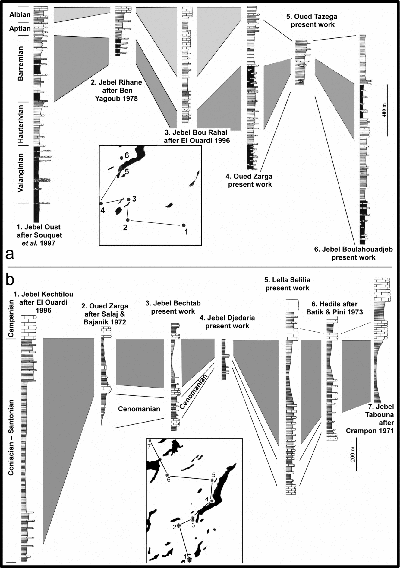
Jebel Boulahouadjeb, in the western part of the Lansarine region, corresponds to an important lower Cretaceous depocenter with numerous resedimented Triassic blocks. A considerable variation in thickness, ranging between 450–500 m in Oued Tazzega and 2000 m in Jebel Boulahouadjeb, illustrates drastic deepening from southeast to northwest. Dynamic salt tectonics can account for segmented blocks of evaporites being extruded onto the surface and then slumping downslope. We interpret the fact that different parts of the salt body were subject to different rates of sedimentation to differential movement on vertical faults between this zone and the neighbouring sector (east Lanasarine).
Jebel Anng (southern part of the LBSS) appears as a NE-tending folded zone (Altasic direction) affected by several 110°N–120°E-trending faults (Fig. 6j). These faults affect all sediments, including Mio–Pliocene strata. Fault surfaces are well exposed within the Campanian–Maastrichtian and Ypresian limestones. This 110°N–120°E-trending fault system exhibits fault kinematics, with striation showing a multiphase history with a first generation indicating normal movement and a second as dextral strike-slip (Fig. 6k). The first period (Tethyan extension) is also recorded by tectono-sedimentary features such as slumps, which are abundant in the Aptian–Albian deposits. The Triassic salt appears subparallel to other sediments and occupies an interlayered position within Albian strata. In this area, two directions of fold axes are observed separated by 15–20°. The first one is 65°N-trending in pre-Oligocene strata and the second with a c. 45°N-trending fold axis in Miocene beds (see Figures 9 & 11 for geological maps). The Oligo–Miocene sediments lie unconfomably on the underlying strata, and testify to two tectonic events in the Eocene and Miocene. The salt sheet, interbedded with middle–upper Albian sediments, was likely to have been extruded from one of the marginal faults currently acting as strike-slip fault.
Jebel Ahmera, in the south, displays evidence of a geometry comparable to that of Jebel Anng. This structure is similarly bounded on northern and southern sides, by E-trending fault zones. Triassic salt is interbedded within the middle-upper Albian formation with both lower and upper ‘conformable’ contacts. Slip deduced from fault kinematic analysis provides evidence for Cenozoic faulting reactivating inherited normal faults. Geological maps (Figs 4, 7, 9, 11) and cross sections (Figs 5, 8, 10, 12), illustrate the present geometry and the original position of the salt in Cretaceous time. The Jebel Ahmera area is also one of the rare domains in Tunisia where it is possible to localize the tectonic inversion between the lower Santonian and the Ypresian. The Ypresian formation unconformably overlies Senonian limestone with a conglomeratic contact of reworked pebbles and cobbles of Cretaceous series which was well studied by Perthuisot (Reference Perthuisot1978).
Jebel Bechtab, located Between Jebel Anng and Jebel Ahmera, presents a Lansarine affinity with a NE-trending structural pattern in particular major faults. Two directions of fold axes are observed with a difference of 15°–20° similar to that seen at Jebel Anng (i.e. 65°N-trending fold in pre-Oligo–Miocene deposits and 45–50°N-trending fold axis in Miocene strata (Fig. 9). The NE-trending faults are thrust faults probably corresponding to inverted normal Cretaceous faults. The substratum of Triassic salt, well identified in Wadi El Bechar, has been uplifted by the the Jebel Bechtab ENE-trending high angle fault.
4.b. Gravity data
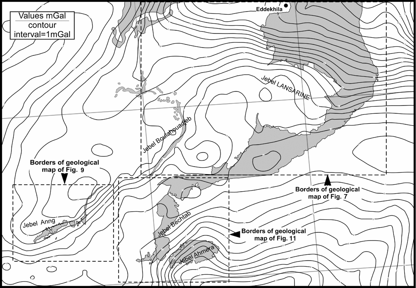
We used gravity data to correlate our field observations with subsurface features. Here, we correlate gravity anomalies with known geological observations acquired in this study. Bouguer anomaly maps (Figs 14, 15) were produced from the analysis of surface measurements of at least one per square kilometre (Office National des Mines, Tunisie, Sial Geosciences Inc., unpub. report, 1999: Gravimétrie en Tunisie, rapports internes) and, in some localities, from denser networks. Stripping or modelling operations were not needed to determine whether or not Triassic evaporitic material is rooted, as the evaporites crop out (Nely, Reference Nely1980).
For the north portion, the resulting complete Bouguer gravity anomaly map provides evidence for values ranging from 5.1 mGal in the northwest, to 23.6 mGal in the southeast and central western parts (Fig. 14). Gravity anomalies are broadly NE-trending in the northeast, northwest, central north, central west and central south of the Baouala region. There are also minor trends in the NW–SE and N–S directions in the central zone and an E-trend in the north and south of Lella Selilia. The Lella Selilia region and eastern Wadi Maïou are distinguishable by high amplitude positive anomalies, which is consistent with our field data. This positive anomaly indicates that salt is underlain by lower Cretaceous limestone and marls characterized by significantly high density values (Fig. 2). The main fault of the northern region (i.e. the Baouala Fault) is well expressed by a NE-trending anomaly line separating two different domains: a broadly northwest zone and a tightly constrained southeast zone.
In the central part of the LBSS, gravity values range from –2 mGal to 15 mGal (Fig. 15). The regional pattern displayed by the gravity map is an elongate NE-trending structure consistent with the Altasic direction. The gravity map also suggests a WNW-trending structure in the eastern part of the Lansarine region. This trend appears to reflect the overall fold and fault pattern, coinciding with the 110°N–120°E-trending fault system. In the southeastern part, low density values represent the Jebel Djedaria syncline, and the development of a thick Miocene sequence characterized by low density values (Fig. 2). In the northwest of Jebel Lansarine, values increase and range from 6 to 12 mGal. Here, the gravity anomaly indicates an anticline: the Jebel Boulahouadjeb anticline, with 2000 m thick lower Cretaceous sediments, represented by a change of 6 mGal (from −2 mGal at Wadi Tazzega to 4 or 5 mGal at Jebel Boulahouadjeb).
From Jebel Bechtab to Jebel Anng (Fig. 15), gravity values increase from ‒2 mGal to 8 mGal. This reflects the anticline structure of Jebel Anng. Geological observations confirm that the lower Cretaceous substratum lithology consists of marly and limy sediments characterized by high density values (Fig. 2). Gravity appears to reflect the overall structure of southern LBSS and this E-trend is also expressed at Jebel Ahmera.
Jallouli et al. (Reference Jallouli, Chikhaoui, Brahem, Turki, Mickus and Benassi2005), Benassi et al. (Reference Benassi, Jallouli, Hammami and Turki2006) and Hamdi-Nasr et al. (Reference Hamdi-Nasr, Inoubli, Ben Salem, Tlig and Mansouri2009, Reference Hamdi-Nasr, Amiri, Inoubli, Ben Salem, Chaqui and Tlig2010) suggested a model in which a salt diapir produced a relative high gravity anomaly that was explained by salt piercing unconsolidated sediments at the surface. Trying to explain the positive Bouguer anomalies, some studies (presenting a rooted diapiric schema of structures: Jallouli et al. Reference Jallouli, Chikhaoui, Brahem, Turki, Mickus and Benassi2005; Benassi et al. Reference Benassi, Jallouli, Hammami and Turki2006) argued that the Triassic material is denser than its sedimentary overburden. Our results (geological observations combined with gravity data) do not fit this model. It is also contradicted by other gravity studies (Talbot, Reference Talbot2005; Riley et al. Reference Riley, Gordon, Simo, Tikoff and Soussi2011). The relationship between salt and gravity anomalies is usually expressed in terms of the density of the Meso–Cenozoic sediments in Tunisia when salt is seen in outcrop (Fig. 2); and also in structures without outcropping salt (Riley et al. Reference Riley, Gordon, Simo, Tikoff and Soussi2011). Riley et al. (Reference Riley, Gordon, Simo, Tikoff and Soussi2011) measured gravity anomalies in structures without salt in the southern Tunisian Atlas mountains producing a reference for the density of Mesozoic and Cenozoic sediments. When salt was incorporated into their model, the low density of the central diapir dominated the gravity signature. The gravimetric data for the LBSS are consistent with our interpretation of the stratigraphical, sedimentological and structural data, that this is a Triassic salt canopy interlayered with Cretaceous sediments and is not rooted. These data do not fit the diaper model, where the lowest Bouguer anamalies would be expected in the core of the structure. A model of the LBSS without salt was able to reproduce the observed gravity anomaly (confirmed in other regions by Riley et al. Reference Riley, Gordon, Simo, Tikoff and Soussi2011).
4.c. Seismic section
Here, we interpret a seismic reflection from Rigo et al.'s (Reference Rigo, Garde, El Euch, Bandt and Tiffert1996) study (Fig. 16). The non-interpreted section was provided by ETAP Petroleum National Company and the acquisition was carried out by Shell-Tunirex Company in 1983. This seismic line, which runs NW–SE, from Mateur to Tebourba town, crosses the LBSS in its northern portion. Along strike of this section, the LBSS domain is bounded by Quaternary deposits. Meso–Cenozoic sediments do not crop out in this section. The interpreted seismic line (Fig. 16) shows the following reflectors: base of the Miocene, Palaeogene, Upper Cretaceous, Lower Cretaceous and Triassic salt (Rigo et al. Reference Rigo, Garde, El Euch, Bandt and Tiffert1996). For us, the most important result provided by this data is that the Triassic salt of LBSS is not rooted as was previously proposed by Zargouni (Reference Zargouni1975) and Perthuisot (Reference Perthuisot1978). This section displays evidence for Triassic salt interlayered between Lower and Upper Cretaceous units. This is consistent with our field observations regarding the relationship between Aptian and middle-upper Albian sediments and the Triassic salt. The thin (10 m thick) horizon of upper Albian cannot be represented on the scale of a seismic profile. The second important result is the northwestward thinning of the salt sheet that confirms the northwestward salt flow on a submarine slope during Cretaceous time. This result is also consistent with field data presented in this work. Another essential result is the highlighting of the Teboursouk Thrust front as a SE-verging thrust. In addition, this seismic profile provides evidence of initial normal movement of the present thrust system, indicated by sediment thickness variations and antithetic faults, remnants of the original normal faulting (Fig. 16).
5. Discussion
The LBSS is about 40–45 km long and its width varies from about 8 km in the north to 15 km in the central part and 4–5 km in the south, covering an approximate area of about 360 km2. This Triassic salt structure was shortened about 30% by NW–SE Cenozoic compressional events and has been subjected to considerable erosion and probably dissolution during the second half of the Mesozoic and the Cenozoic eras. It is likely to have covered a wider area in late Mesozoic and Palaeogene times. We estimate that the LBSS had a surface area of at least 550 km2 during Cretaceous time (accounting only for 30% compression, and disregarding erosion and dissolution).
The LBSS was interpreted by previous workers as a forceful diapiric structure (Zargouni, Reference Zargouni1975; Perthuisot, Reference Perthuisot1978). Jebel Baouala, Jebel Lansarine, Jebel Bectab, Jebel Anng and Jebel Ahmera were interpreted as belonging to one diapir. This large rooted diapir was called the Lansarine diapir and was presented with a 40 km wide feeding stem. The interpretation of the salt in the Lansarine area comprising a single, unusually large-rooted diapir is inconsistent with the results of our field mapping. Thus the cartographic outlines of the Triassic salt (and its internal layering) commonly subparallel to the bedding in adjoining rock sequences. The contacts of the Triassic are never discordant with bedding in the surrounding strata. Our maps and profiles are consistent with an allochthonous sheet of Triassic salt having been emplaced slightly transgressively at much the same stratigraphic level as the middle Cretaceous throughout the region. Field data emphasize the absence of radial faults that are usually associated with an active diapir or the result of salt dome or diapir growth (Parker & McDowell, Reference Parker and McDowell1955; Trusheim, Reference Trusheim1960; Rowan et al. Reference Rowan, Lawton, Giles and Ratliff2003; Yin & Groshong, Reference Yin and Groshong2007; Yin et al. Reference Yin, Zhang, Meng, Liu and Xu2009). Further, the salt budget is consistent with an allochthonous salt sheet model, and must be insufficient if we suppose a 40 km-long, rooted structure as presented in previous studies. The Triassic salt shows an interstratified position within Cretaceous sequences, well defined throughout its cartographic outline and stratigraphically continuous with the top and bottom of this series, through conformable contacts (Figs 4, 5, 7–12). Based on field investigation, we therefore suggest a salt sheet interlayered with Cretaceous sediments. Our model is not in agreement with previous interpretations.
There are two main unconformities in the area, neither of which is associated with the Triassic rocks (Figs 4, 5, 7–12). The first significant unconformity concerns the Oligocene – Lower Miocene contact. In Jebel Djerdaria (Figs 7, 8), and Jebel Bechtab (Figs 9, 10) the Oligocene sediments overlay, with gentle angular unconformity, Cretaceous strata that cover the Triassic material. Unfolding of the Oligocene – Lower Miocene strata does not support the presence of an intrusive diapiric structure. It instead reveals broadly Eocene folds. The second unconformity concerns the Miocene–Pliocene contact (Figs 11, 12). It corresponds to the Alpine intra-Tortonian major tectonic phase (Guiraud & Bosworth, Reference Guiraud and Bosworth1997; Masrouhi et al. Reference Masrouhi, Ghanmi, Ben Slama, Ben Youssef, Vila and Zargouni2008). During this phase the entire structure was folded and the Lansarine thrust nappe emplaced (Masrouhi et al. Reference Masrouhi, Ghanmi, Ben Youssef, Vila and Zargouni2007).
Cretaceous sediments cropping out in the LBSS correspond to deep-sea basin facies deposits, testifying to the deepening of the basin (Figs 16, 17). The upper Albian – lower Senonian sediments overly the salt body (Figs 4, 5, 7–12, 17), and are characterized by considerable variation in thicknesses ranging from some tens of metres to several hundred metres. These thickness variations are not accompanied by changes in their pelagic to hemi-pelagic facies. Instead, they exhibit numerous sedimentary features (nodule reworking, slumps and the conglomerate lenses) indicating an irregular sea floor contemporaneous with an active extensional tectonic regime.
(a) Lower and (b) Upper Cretaceous lithostratigraphical correlation of outcrop data showing variation in sediment thickness caused by synsedimentary faults.

We note that in several localities the Triassic salt shows a planar bedding (layered arrangement), especially the gypsum beds, which is sub-parallel to the Cretaceous beds plunging under the salt and also to those that cover it. This planar bedding suggests a flow of salt in Cretaceous time. Moreover, the contact of salt is usually glauconitic and conglomeratic, with Triassic insoluble elements, indicating a possible rapid flow of salt onto the Aptian and Albian sea floor in a deep marine environment (indicated by a mixed pelagic and benthic micropalaeontological fauna). In addition, in several localities, along these contacts, there are abundant slumps and carbonates nodules (septaria type) of Cretaceous age recording the existence of a sub-marine slope over which salt had spread.
The most important result from the seismic profile across the northern LBSS (Rigo et al. Reference Rigo, Garde, El Euch, Bandt and Tiffert1996) is the evidence that Triassic salt is not rooted as it was previously proposed (Zargouni, Reference Zargouni1975; Perthuisot, Reference Perthuisot1978). This seismic section shows a layer of Triassic salt interlayered between Lower and Upper Cretaceous strata. The second important result is the thinning of salt sheet northwestward confirming geological observations, i.e. the northwestward salt flow during Cretaceous time on a submarine slope. In addition, this section highlights the Teboursouk Thrust Fault, which is a SE-verging thrust that was reactivated by inversion of a previously normal fault.
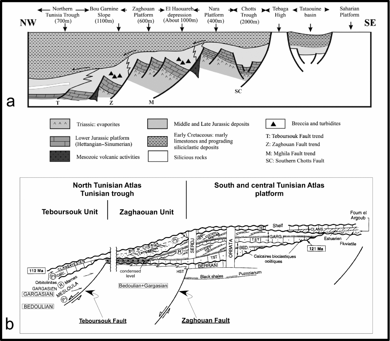
Several studies of this margin (e.g. Souquet et al. Reference Souquet, Peybernes, Saadi, Ben Youssef, Ghanmi, Zarbout, Chikhaoui and KAmoun1997) have confirmed that it was an extensive margin during the Cretaceous and was characterized by normal faulting and tilted block architecture (Fig. 18) particularly along two major faults, the Zaghouan-Ressas Fault and Teboursouk Fault. In Cretaceous time, these were two major structural features (normal faults) controlling sedimentation. These faults are suggested to have been active since Jurassic time (Soussi, Reference Soussi2002; Boughdiri et al. Reference Boughdiri, Cordey, Sallouhi, Maalaoui, Masrouhi and Soussi2007).
Schematic cross-section constraining the configuration of the North African margin and associated sedimentary facies in Tunisia not long before the extrusion and downslope flow of the remobilised Triassic evaporates (a) during the Jurassic – Early Cretaceous after Soussi, Reference Soussi2002 and (b) during lower Cretaceous slightly modified after Souquet et al. (Reference Souquet, Peybernes, Saadi, Ben Youssef, Ghanmi, Zarbout, Chikhaoui and KAmoun1997).

Rock salt contains over 0.01% of water and is a very weak crystalline fluid (Urai, Reference Urai, Spiers, Zwart and Lister1986; Talbot, Reference Talbot1993; Weijermars, Jackson & Vendeville, Reference Weijermars, Jackson and Vendeville1993). Incompressible at depth, salt tends to flow like any other Newtonian fluid. In several sedimentary basins, numerous studies reported important sheets of allochthonous salt which rose diapirically through their overburden, extruded, and then flowed downslope over the surrounding land surface or sea floor (Fletcher, Hudec & Watson, Reference Fletcher, Hudec, Watson, Jackson, Roberts and Snelson1995; Jackson, Vendeville & Schultz-Ela, Reference Jackson, Vendeville and Schultz-Ela1994; Koyi, Talbot & Tørudbakken, Reference Koyi, Talbot, Tørudbakken, Jackson, Roberts and Snelson1995; Hudec & Jackson, Reference Hudec and Jackson2006; Talbot & Pohjola, Reference Talbot and Pohjola2009). There are several salt provinces where large allochthonous salt sheets are present (collected on Fig. 19a). The Atlas salt province has not previously been recognized as such. We argue in this work and other recent studies (Vila, Reference Vila1995; Vila et al. Reference Vila, Ghanmi, Ben Youssef and Jouirou2002; Masrouhi & Koyi, Reference Masrouhi, Koyi, Alsop, Archer, Hartley, Grant and Hodgkinson2012) that this margin presents wide large allochthonous salt sheets which extruded during the Cretaceous extensional phase. These salt sheets were folded in Cenozoic time by shortening, complicating their extrusional characteristics. Consequently, it is sometimes difficult to distinguish the original features of the structure and the modifications acquired during the complex history of this margin. The LBSS is located just north of Teboursouk Thrust Front (the main decollement surface enabling the continuous Cenozoic shortening in this area). However, the LBSS has preserved some of the features of the salt canopy of Cretaceous time. Where this is the case, it is comparable to the simple salt glacier of the Medjez-el-Bab structure, located just south of the Teboursouk Thrust Front (Masrouhi et al. Reference Masrouhi, Ghanmi, Ben Youssef, Zargouni and Vila2005; Masrouhi & Koyi, Reference Masrouhi, Koyi, Alsop, Archer, Hartley, Grant and Hodgkinson2012).
(a) Worldwide salt sheets with superimposed tectonic plates, collected from the works of Jackson, Vendeville & Schultz-Ela, Reference Jackson, Vendeville and Schultz-Ela1994; Diegel et al. Reference Diegel, Karlo, Schuster, Shoup, Tauvers, Jackson, Roberts and Snelson1995; Fletcher, Hudec & Watson, Reference Fletcher, Hudec, Watson, Jackson, Roberts and Snelson1995, Jackson, Reference Jackson, Jackson, Roberts and Snelson1995; McBride, Rowan & Weimer, Reference McBride, Rowan, Weimer and Hurley1998; Barde et al. Reference Barde, Gralla, Harwijanto and Marsky2002; Vila et al. Reference Vila, Ghanmi, Ben Youssef and Jouirou2002; Rowan et al. Reference Rowan, Lawton, Giles and Ratliff2003; Maillard et al. Reference Maillard, Gaullier, Vendeville and Odonne2003; Canérot, Hudec & Rockenbauch, Reference Canérot, Hudec and Rockenbauch2005; Hudec & Jackson, Reference Hudec and Jackson2006; Gaullier & Vendeville, Reference Gaullier and Vendeville2005; Jackson & Harrison, Reference Jackson and Harrison2006; Hudec & Jackson, Reference Hudec and Jackson2007; Mohr et al. Reference Mohr, Warren, Kukla, Urai and Irmen2007; Hudec & Jackson, Reference Hudec and Jackson2009; Talbot & Pohjola, Reference Talbot and Pohjola2009; Davison et al. Reference Davison, Alsop, Evans and Saafricz2000; Brun and Fort, Reference Brun and Fort2012; Fort and Brun, Reference Fort, Brun, Alsop, Archer, Hartley, Grant and Hodgkinson2012, among others. (b) Currently recognized salt canopy outcrops.

The context of the extensional tectonic regime related to the Cretaceous margin structural setting offers at least two factors allowing salt to extrude onto the sea floor and flow downslope toward deeper marine conditions: (i) tectonic extension, which weakened the overburden units by forming the main normal faults and creating the space for the salt to rise. This tectonic regime was also responsible for a sub-marine slope as clearly evidenced by slumps and nodules, on which salt can flow and spread; (ii) differential sedimentation, which drove the salt. We argue that differential loading and faulting are the two main mechanisms for salt movement.
The Teboursouk, Baouala, Bechtab, and Ahmera faults were likely feeders for the salt mass. We suggest that salt was originally intruded into the overburden units which were weakened by the normal synsedimentary faults system formed during the Cretaceous thin-skinned extension of the passive margin. In the southern part of the LBSS, the 110°N–120°E-trending fault system exhibits kinematic indicators, pointing to an initial normal movement followed by a later strike-slip movement. Salt was probably extruded from one of the, currently strike-slip, marginal faults.
Sub-marine salt sheets of the LBSS in Cretaceous time were likely to have been asymmetric and spread basin-ward (northwestward) over the half graben at superficial levels. Field tectono-sedimentary data from the Lansarine–Baouala locality, presented above, testify to a margin defined by NW-dipping normal faults. The salt sheets become thinner towards the northwest. This study, and other regional overview studies (e.g. Souquet et al. Reference Souquet, Peybernes, Saadi, Ben Youssef, Ghanmi, Zarbout, Chikhaoui and KAmoun1997) confirm a NW-dipping submarine slope. In addition, salt sheets are usually associated with faults (Baouala, Teboursouk, Bechtab and Ahmera faults). Moreover, the Cretaceous extensional tectonic regime was responsible for a northwestward thickening of sediments. This geological tectono-sedimentary context suggests that the feeding stems of the salt sheets are in the southeast (Fig. 13).
6. Conclusion
The compilation of geological maps and cross-sections, analysis of the age of the sedimentary layers below and above the salt, gravity and seismic data, thickness change (direction of thinning), and internal structure of the salt sheet, all suggest the presence of several feeders for the present coalesced salt mass of the LBSS, which is interpreted here as a salt canopy (Fig. 13). Field investigations show that this unique salt sheet was fed by at least four stems, i.e. the Baoula Fault in the northern portion, the Teboursouk major fault of the main salt body in the south and two other feeders south of the Jebel Ahmera and south of Jebel Bechtab. Our conclusions are based on the following:
(1) The Early Cretaceous context in northern Tunisia salt supply rate that was greater than rate of sedimentation, resulting in the formation of salt sheet spreading at the water-sediment interface.
(2) The Teboursouk, Baouala, Bechtab and Ahmera faults were likely to be the feeders of the salt mass of the LBSS. We suggest that salt rose up diapiric walls through the overburden which was weakened by normal synsedimentary faults formed during the Cretaceous thin-skinned extension of the passive margin. This extruded salt would have spread onto the sea floor and flowed downslope (northwestwards) forming large salt sheets; much as happens today in the Gulf of Mexico. These salt sheets coalesced to form a salt canopy, which was later buried by Cretaceous and Cenozoic sediments.
(3) The LBSS on the North African continental margin is recognized here as being the third example in the world of a subaerial terrestrial salt canopy. It resulted from several submarine sheets of allochthonous Triassic salt coalescing in mid-Cretaceous times.
Acknowledgements
We are grateful to Editor Dr Mark Allen and the anonymous reviewer for providing constructive reviews that significantly improved this article. AM would like to acknowledge Sally Thomas for improving the final manuscript.