Introduction
While conservation paradigms have evolved in their views of human–nature relationships, the current framing of ‘people and nature’ promotes an inclusive focus on environmental conservation and human needs (Mace Reference Mace2014). This view is particularly relevant to species that depend on humanized areas for their survival, as it emphasizes the importance of human activities in achieving sustainable human–wildlife interactions (Cumming Reference Cumming2016, Mace Reference Mace2014). This new conceptualization is promising since reconciling the needs of stakeholders with the conservation goals of protected areas (PAs) has been one of the major challenges in conservation biology. PAs are classified by the International Union for Conservation of Nature (IUCN) according to their management aims (Dudley Reference Dudley2008). They have traditionally been thought of as places with low levels of human activity, with such activities being almost non-existent in the most strictly controlled areas. However, it is well known that these areas are insufficient to protect many species, including those with large home ranges or that use humanized areas (Krüger et al. Reference Krüger, Reid and Amar2014, Lambertucci et al. Reference Lambertucci, Alarcón, Hiraldo, Sanchez-Zapata, Blanco and Donázar2014, Phipps et al. Reference Phipps, Willis, Wolter and Naidoo2013).
Biosphere reserves (BRs) are one example of PAs that have the potential to improve the conservation of species that use humanized areas. They were established in 1971 under UNESCO’s Man and the Biosphere (MAB) Programme to improve the relationship between people and their environments, harmonizing biodiversity conservation and sustainable development based on scientific knowledge (Batisse Reference Batisse1982, UNESCO 1996). Each BR comprises three different zones: a core, a buffer and a transition area. Only the core area is strictly protected (including at least one IUCN PA), with human activities that foster sustainable development allowed in both buffer and transitional areas (UNESCO 1996). These areas increase the amount of protected landscape and ultimately connect PAs recognized by the IUCN, which should result in important benefits for highly mobile species (Runge et al. Reference Runge, Martin, Possingham, Willis and Fuller2014, Tucker et al. Reference Tucker, Böhning-Gaese, Fagan, Fryxell, Van Moorter and Alberts2018) and those with long dispersal distances (Krüger et al. Reference Krüger, Reid and Amar2014, Phipps et al. Reference Phipps, Willis, Wolter and Naidoo2013). While the effectiveness of BRs in landscape protection has been widely studied (Coetzer et al. Reference Coetzer, Witkowski and Erasmus2014), much less attention has been paid to the role that BRs play in protecting wide-ranging species (but see Ma et al. Reference Ma, Li, Li, Han, Chen and Watkinson2009).
Over the years, PAs have changed their conservation targets from a species-specific focus or singular landscapes to an ecosystem conservation approach. Nonetheless, PAs have not historically been designed to protect wide-ranging species (Runge et al. Reference Runge, Martin, Possingham, Willis and Fuller2014), but have mainly considered threatened or endemic species (Bonn et al. Reference Bonn, Rodrigues and Gaston2002). Thus, wide-ranging species frequently use unprotected areas where regulations are almost absent and where controls and management are scarce (Coetzer et al. Reference Coetzer, Witkowski and Erasmus2014). This exposes them to a wider diversity of threats. In these areas, human–wildlife conflicts are common and threaten several of the species that use them (Ogada et al. Reference Ogada, Keesing and Virani2012). The challenge is particularly great for scavenger birds, since individuals face different types of threats both on the ground and in the air (Lambertucci et al. Reference Lambertucci, Shepard and Wilson2015, Runge et al. Reference Runge, Martin, Possingham, Willis and Fuller2014). Outside of PAs, endangered species can be exposed to direct threats such as through persecution (Ogada et al. Reference Ogada, Keesing and Virani2012) and poaching (Litchfield Reference Litchfield2013), or indirect threats such as habitat fragmentation (Speziale et al. Reference Speziale, Lambertucci and Olsson2008), unintentional poisoning (Ogada et al. Reference Ogada, Keesing and Virani2012, Wiemeyer et al. Reference Wiemeyer, Pérez, Bianchini, Sampietro, Bravo and Jácome2017) and collision with human infrastructure such as buildings, aircraft, drones and powerlines (Lambertucci et al. Reference Lambertucci, Shepard and Wilson2015). Therefore, individuals of species that spend more time in unprotected areas are comparatively less protected and more exposed to threats (Ogada et al. Reference Ogada, Keesing and Virani2012, Thiollay Reference Thiollay2006).
The Andean condor (Vultur gryphus) is globally ‘Near Threatened’. It is included in CITES I (Birdlife International 2017) and is categorized as ‘Threatened’ in Argentina (MAyDS & AA 2017), where a large population occurs (Lambertucci Reference Lambertucci2010). Adult condors perform long-distance movements (more than 350 km in a day) and have large home ranges (Lambertucci et al. Reference Lambertucci, Alarcón, Hiraldo, Sanchez-Zapata, Blanco and Donázar2014). During these trips, they cross several political boundaries, including those of PAs, provinces and countries (Lambertucci et al. Reference Lambertucci, Alarcón, Hiraldo, Sanchez-Zapata, Blanco and Donázar2014). As the exploratory movements of immature birds during the dispersal period may occur over even larger areas than those of adults, this exposes them to multiple threats, especially outside PAs (Krüger et al. Reference Krüger, Reid and Amar2014, Phipps et al. Reference Phipps, Willis, Wolter and Naidoo2013). Thus, PAs are generally too small for this species (Lambertucci et al. Reference Lambertucci, Alarcón, Hiraldo, Sanchez-Zapata, Blanco and Donázar2014). The movement patterns of wild immature condors are mostly unknown. During dispersal, immature individuals are not territorial and can continuously explore new areas in the search for food resources, which creates a challenge in designing suitable conservation strategies. Thus, it is essential to understand the ranging behaviour of this portion of the population in order to identify potential threats and improve current management and conservation strategies for the species. In this sense, large PAs that include the relationship between people and their environments, such as BRs, could be important for scavengers and particularly for immature birds.
Here, we explore the extent to which immature condor movements overlap with different PAs. Specifically, we study the space use by immature Andean condors in order to evaluate how much of their home ranges are covered by PAs. We also evaluate the increase in overlap between condor movements and the type of PA. For these purposes, we tracked the movement of immature individuals in Patagonia by means of GPS-based telemetry. We hypothesized that BRs increase the area that is protected, and this is important for immature condors, since BRs protect lands that include human activities such as sustainable livestock ranching where condors forage. We predicted that birds would prefer BRs, even when they use different areas. To this end, we evaluated condor habitat preference conditioned by a sample of availability of unprotected areas, IUCN PAs and BRs with a use–availability design (Beyer et al. Reference Beyer, Haydon, Morales, Frair, Hebblewhite, Mitchell and Matthiopoulos2010).
Materials and methods
Study area
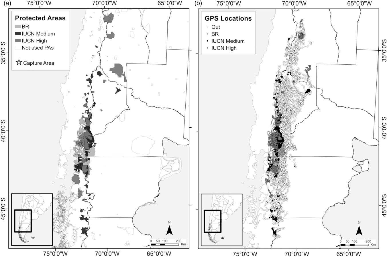
The study was carried out in Patagonia (33–48°S, 68–72°W). The specific area was determined by the movement patterns of the tagged birds, which covered a large part of Andean Patagonia (Argentina–Chile) (Fig. 1 & Supplementary Fig. S1, available online). This area includes a west-to-east gradient of coastline, high mountain environments, temperate forests, pastures and sub-Andean steppes. The Andes Mountains become flatter to the east, turning first into a transitional area (‘ecotone’) and then into the Patagonian Monte (north) and the Steppe (south) ecoregiones (Dinerstein et al. Reference Dinerstein, Olson, Joshi, Vynne, Burgess and Wikramanayake2017) (Supplementary Fig. S1). Given the population retraction that most terrestrial native herbivore species have experienced, condors commonly use the flattest areas of the ecotone and Steppe to feed on domestic (livestock) and wild herbivores (Lambertucci et al. Reference Lambertucci, Trejo, di Martino, Sánchez-Zapata, Donázar and Hiraldo2009b). Overexploitation of marine wildlife on the Chilean coastline may have contributed to this change in diet, as it reduced availability of marine prey (Lambertucci et al. Reference Lambertucci, Navarro, Zapata, Hobson, Alarcón and Wiemeyer2018). Due to the dense canopies of forests in the west of the Andes and the low availability of herbivore carcasses, condors do not feed in those areas. In Patagonia, the mountains between Chile and Argentina mainly serve as nesting and roosting sites (Lambertucci et al. Reference Lambertucci, Trejo, di Martino, Sánchez-Zapata, Donázar and Hiraldo2009b, Reference Lambertucci, Navarro, Zapata, Hobson, Alarcón and Wiemeyer2018). In the study area, the main PAs are located along the mountains mostly covering the sub-Antarctic forest; this area has a large number of cliffs that are used for breeding or roosting. However, only 4% of the Monte and Steppe ecoregions is protected, with <1% belonging to a national park (Brown et al. Reference Brown, Martinez Ortiz, Acerbi and Corcuera2006). With regards to the Andes Mountains, 10% and 34% of its total area is protected in Chile and Argentina, respectively (Brown et al. Reference Brown, Martinez Ortiz, Acerbi and Corcuera2006, Lara et al. Reference Lara, Donoso, Aravena, Armesto, Villagrán, Armesto, Villagrán and Arroyo1996).
(a) Distribution of protected areas (PAs) in the study area (IUCN & UNEP-WCMC 2017). In light grey are shown the biosphere reserves (BRs) used by tagged immature Andean condors. In black are shown the PAs categorized as International Union for Conservation of Nature (IUCN) levels IV–VI. In dark grey are shown the PAs categorized as IUCN levels I–III. In white are shown all existing PAs in the study area but not used by the tagged immature condors. (b) Locations of 26 immature tagged Andean condors separated by categories of conservation of the PAs. The white dots were immature condors outside of any PAs. In light grey are shown the GPS locations of condors located inside the BRs. In black are shown the individuals that use PAs categorized by the IUCN levels IV–VI. In dark grey are shown the PAs categorized by the IUCN levels I–III (see details in the ‘Materials and methods’ section) (Dudley Reference Dudley2008).

Study species
The Andean condor is distributed along the Andes from Venezuela to southern Argentina and Chile (Ferguson-Lees & Christie Reference Ferguson-Lees and Christie2001). It is a long-lived, slow-reproducing bird that commonly lays one egg every 2 years. After a successful hatching, the chick spends up to 6 months inside the nest, and may remain with its parents until 15 months of age. It has a long immature period of up to 6 years (Ferguson-Lees & Christie Reference Ferguson-Lees and Christie2001, Lambertucci Reference Lambertucci2007). Condors are among the largest flying birds with a wingspan and weight that can exceed 3 m and 16 kg, respectively (Alarcón et al. Reference Alarcón, Morales, Donázar, Sánchez-Zapata, Hiraldo and Lambertucci2017, Ferguson-Lees & Christie Reference Ferguson-Lees and Christie2001). Their large size imposes space-use restrictions, as they need specific environmental conditions to fly with low energy requirements (Shepard et al. Reference Shepard, Wilson, Rees, Grundy, Lambertucci and Vosper2013). However, condors can cover several hundreds of kilometres; the maximum home range estimated for an adult was 77 309 km2 (Alarcón Reference Alarcón2016). Their huge movements often result in individuals moving between two countries (Lambertucci et al. Reference Lambertucci, Alarcón, Hiraldo, Sanchez-Zapata, Blanco and Donázar2014, Pavez Reference Pavez2014). Andean condors are obligate scavengers that, in Patagonia, currently feed mainly on mammal carcasses, particularly livestock and other wild exotic species that replaced the native fauna (Lambertucci et al. Reference Lambertucci, Trejo, di Martino, Sánchez-Zapata, Donázar and Hiraldo2009b, Reference Lambertucci, Navarro, Zapata, Hobson, Alarcón and Wiemeyer2018). These feeding habits expose them to threats such as lead contamination, poisoning and persecution (Alarcón & Lambertucci Reference Alarcón and Lambertucci2018, Lambertucci et al. Reference Lambertucci, Donázar, Huertas, Jiménez, Sáez, Sanchez-Zapata and Hiraldo2011).
Bird tagging
During the austral spring–summer seasons between 2013 and 2018, we trapped and tagged 26 immature Andean condors (14 females and 12 males) between 2 and 5 years old using cannon net traps baited with sheep carcasses in the surroundings of Bariloche city (41°13'8.48"S, 71°4'39.44"W). This area is located at the limit between Nahuel Huapi National Park and private lands, close to the border of the Andino Norpatagónica BR (Fig. 1). We tagged 17 birds with backpack 100-g solar GPS-GSM CTT® (NorthStar-VektorTek LLC), four with backpack 90-g solar CTT-1090 GPS-GSM (Cellular Tracking Technologies) and five with 75-g solar CTT-1000-BT3-Series GPS-GSM, third generation (Cellular Tracking Technologies) (Supplementary Table S1). The weights of the devices varied between 75 and 100 g (<1.5% of the weight of the bird) and were fitted with Teflon ribbon backpack harnesses. All of the tags were duty-cycled to transmit every day from dawn to dusk at the minimum time interval allowed by the tags (i.e., every 15 minutes). Tags recorded the speed and geographical coordinates of the birds.
Data analysis
Data processing. We obtained the GPS locations from the 26 tagged immature condors between the times that each bird was released until January 2019 or until the time the unit stopped working. Only the devices placed in 2018 are still transmitting – the others stopped at different time intervals (Supplementary Table S1), so the monitoring periods differed between individuals. We could not detect the causes for transmitter failure, but similar errors are frequently reported in telemetry studies (Hofman et al. Reference Hofman, Hayward, Heim, Marchand, Rolandsen and Mattisson2019). In order to standardize the interval times between GPS locations and to minimize serial dependence between consecutive locations, we used a subsample of our dataset including only a random GPS location per day coming from a location at any time during the day. This decision was made based on the results of the autocorrelation analysis, which was made using the acf() function in R software (R Core Team 2017). This analysis was done for each individual in relation to the category of the landscape used in each GPS location (collected every 15 minutes). We considered the days with at least 45 GPS locations to minimize the possible bias produced by the amount of data between days. As the test indicated that the amount of data needed to avoid autocorrelation is 63 GPS locations (based on the mode and the median of all individuals), the necessary interval time between two GPS locations is c. 16 hours, so we used one data point per day.
In addition, in order to ensure that the sampling duration covered the full range of variation in movement behaviour of the condors, we considered the home range asymptotes (Laver Reference Laver2005) using as references the asymptotic value of the home range curves (100 GPS locations) estimated for adult condors (Alarcón Reference Alarcón2016). Therefore, for this analysis, only the birds that reached at least 100 GPS locations (i.e., at least 100 days of GPS data) were considered. For every spatial analysis, GPS locations were projected into the Universal Transverse Mercator (UTM) coordinate system (WGS-1984 UTM Zone-19S) and analysed using R (R Core Team 2017) and ArcGIS v.10.3 (ESRI, Inc.).
In order to describe the area covered and calculate the proportion of PAs used by the tagged immature condors that met the criteria mentioned above, we assessed a combination of home range estimators using a pooled dataset (i.e., the total GPS locations obtained from condors tagged that, after subsampling a random location per day, reached a total of 100 GPS locations; Fieberg & Bo Reference Fieberg and Bo2012, Walter et al. Reference Walter, Onorato and Fischer2015). Home range estimators were based on 100% and 95% minimum convex polygons (MCPs) and 99%, 95% and 50% volume contours of kernel density estimators (KDEs). We applied a smoothing factor of 7000 following the ad hoc criteria suggested by Laver (Reference Laver2005), using the adehabitatHR and rgdal packages in R (R Core Team 2017). Each home range estimate was then overlapped with the PAs available. For this purpose, we used the shapefile of PAs provided by the World Database on Protected Areas (IUCN & UNEP-WCMC 2017). We classified each area within the home range into one of four categories according to the protection level of the landscape: ‘Out’, ‘BR’, ‘IUCN Medium’ and ‘IUCN High’ (Table 1). We then calculated the proportion of each landscape category within the area of each home range estimate. Similarly, we assigned each GPS location to one of four levels of landscape protection. All GPS locations in places without protection were assigned to the category ‘Out’, whereas GPS locations inside a BR (according to the MAB Programme; UNESCO 1996) but outside of any PA categorized by the IUCN (Dudley Reference Dudley2008) were grouped into the category ‘BR’. The PAs recognized by the IUCN were split into two categories depending on the protection level. The category ‘IUCN Medium’ includes the PAs with a lower protection level and more human activities, whereas the ‘IUCN High’ category includes the PAs with more restrictions (Table 1). It is important to note that some of those IUCN PAs may also be included in a BR; in those cases, we only considered the IUCN category. This was done in order to separate lands that are only BRs from those that are also IUCN PAs.
Description of the characteristics used to classify the different areas according to their level of protection (Dudley Reference Dudley2008).

BR = biosphere reserve; IUCN = International Union for Conservation of Nature.
Statistical analysis. To evaluate how immature Andean condors allocate time to areas with different protection levels, we used the number of locations as a proxy of time and conducted three comparisons: (1) unprotected areas (Out) versus all PAs taken together (i.e., BRs and IUCN reserves); (2) unprotected areas or those with low protection (Out and BR) versus PAs categorized by the IUCN (Medium and High); and (3) the four protection categories considered (Out, BR, IUCN Medium and IUCN High). To reduce possible biases caused by different sample sizes among birds, we conducted these comparisons using balanced 100-location random samples. This value corresponds to the minimum number of GPS locations necessary to reach the asymptotic value of the home range curves in Andean condors (Alarcón Reference Alarcón2016). As a result, these comparisons included data from 12 individuals (Supplementary Table S2).
We applied a use–availability design to evaluate whether the birds used the different protection categories according to their available surface area or whether they preferred particular categories. Under this approach, the use of a given category was considered selective if it was disproportionately used more frequently compared to its availability (Beyer et al. Reference Beyer, Haydon, Morales, Frair, Hebblewhite, Mitchell and Matthiopoulos2010). We obtained the availability sample by generating five hypothetical animal locations within a 25-km radius centred in each GPS location. The 25–km value was established based on the average distance that birds flew in 1 hour. Space use was then modelled as a Bernoulli process (0: simulated location, 1: GPS location), where the probability of use was a logistic function of landscape protection category. The category ‘Out’ was set as the reference category in the model (i.e., as the intercept), as it represents the lack of protection. The regression coefficients associated with the three remaining protection categories (βBR, βIUCN-Medium and βIUCN-High) measured how likely it was that an individual would be found in these types of areas in comparison to unprotected areas. To capture the hierarchical structure of the data (where GPS locations were nested into individual birds), we estimated a Bayesian hierarchical model using Markov chain Monte Carlo techniques using JAGS (Plummer Reference Plummer2003) via the jagsUI package in R software (R Core Team 2017). We used vague priors (i.e., t-distribution with mean equal to 0, precision equal to 5 and k value equal to 1) and ran three chains with 10 000 iterations each, discarding the first 5000 as burn-in. We evaluated convergence by means of R-hats and used the mean and credible intervals of posteriors for model inference (Gelman & Hill Reference Gelman and Hill2006). To estimate this model, we used three different datasets: (1) all of the tagged condors (26); (2) the 12 tagged birds that reached the asymptotic value of the home range curves (Alarcón Reference Alarcón2016, Laver Reference Laver2005); and (3) the whole dataset of the birds that provided data for at least 1 month (i.e., 19 tagged birds with data collected every 15 minutes). As the three models presented similar results, we decided to present here only the results of the dataset from the 12 birds used in previous analyses in the main text. However, we included all of the results for the three datasets in the Supplementary Material (results for all birds in Supplementary Fig. S2 and results from 19 individuals compared with the entire dataset in Supplementary Fig. S3).
Results
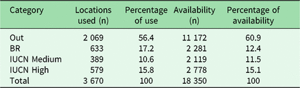
From the 26 tracked immature condors, we obtained a total of 114 355 GPS locations (Fig. 1). However, for the home ranges analysed, we obtained 3670 GPS locations from 12 tracked immature Andean condors (Supplementary Fig. S4) that reached the asymptotic value of the home range curves, which, taken together, used an area of between 160 000 and 290 000 km2 (MCP-100% = 288 811.68 km2; MCP-95% = 255 110.4 km2; KDE-99% = 161 219 km2; KDE-95% = 107 177.35 km2; KDE-50% = 15 665.9 km2) (Supplementary Table S3). Of the total surface area used by the tagged birds based on MCP-100%, 75.3% was unprotected landscape, whereas 14.4% was IUCN PA (IUCN Medium: 5.9% and IUCN High: 8.6%), and the remaining 10.1% was recognized only as BR (Supplementary Table S3). However, of the total GPS locations obtained, 56.4% did not have any type of protection, 26.4% was protected under the IUCN criteria (with 10.6% of the data inside less restricted areas (IUCN Medium) and 15.8% inside the strictest areas (IUCN High)) and the remaining 17.2% was protected only by a BR (Table 2).
Numbers and percentages of GPS locations (a random location per day at any time of the day) of immature Andean condors and available locations (see details in the ‘Materials and methods’ section) separated by the different categories of landscape protection.

Out: unprotected areas; BR: only protected by BRs; IUCN Medium: protected areas categorized by the IUCN levels IV–VI; IUCN High: protected areas categorized by the IUCN levels I–III.
BR = biosphere reserve; IUCN = International Union for Conservation of Nature.
Source: World Database on Protected Areas (IUCN & UNEP-WCMC, 2017).
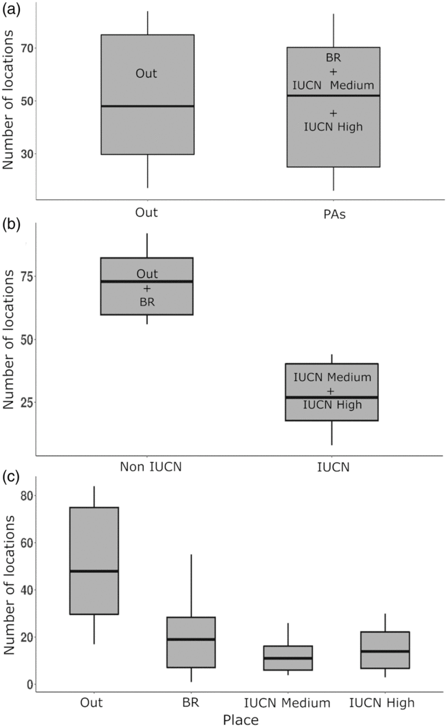
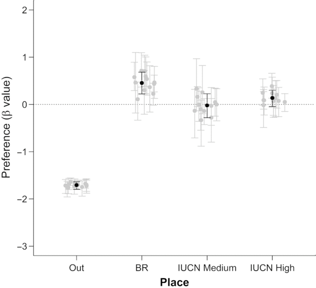
We found no differences between the use of unprotected areas and the PAs pooled together; however, the tagged birds spent more time in unprotected areas (Fig. 2(a)). Moreover, when we compared the time they spent in unprotected landscapes versus landscapes protected by the IUCN criteria, we found that unprotected areas were used more than IUCN PAs (Fig. 2(b)). In the same way, when we compared the time they spent in each area separately, the use of unprotected areas was higher than for all of the PA categories (Fig. 2(c)). Our preference model showed that, when compared to unprotected areas, immature condors used the BRs disproportionately more than their availability (Fig. 3 & Supplementary Fig. S3). However, no pattern was observed for IUCN areas, regardless of the protection category, as these areas were used in the same proportion as expected by chance.
Comparisons between the numbers of condor locations in areas with different protection categories (IUCN & UNEP-WCMC, 2017). (a) Comparison between the number of GPS locations of 12 immature Andean condors in unprotected areas (‘Out’) and protected areas (‘BR’ – only protected by BRs; ‘IUCN Medium’ – PAs at IUCN levels IV–VI; ‘IUCN High’ – PAs at IUCN levels I–III). (b) Comparison between unprotected areas plus the areas of the BRs that are not in an IUCN protected area (i.e., Out + BR) with IUCN PAs (i.e., IUCN Medium + IUCN High). (c) Comparison between areas with different levels of protection – Out, BR, IUCN Medium and IUCN High. BR =biosphere reserve; IUCN = International Union for Conservation of Nature; PA = protected area.

Habitat preferences of 12 immature Andean condors for areas with different levels of protection based on the preference model. The β parameters measure the importance of the level of protection of an area in determining the probability of use of that area. Positive β values indicate preference for areas with that category of protection, whereas negative β values indicate avoidance of the area. The black dots represent the mean β values and their 95% confidence intervals. The grey dots represent the individual β values with their corresponding confidence intervals. BR = biosphere reserve; IUCN = International Union for Conservation of Nature.

Discussion
We found that immature Andean condors spent much more time in unprotected areas than in BRs or IUCN PAs. However, according to our analysis of habitat preference, these birds preferred BRs. In the study area, the creation of the BR increased the surface area of protected landscape by 10.1% (based on MCP-100%; Supplementary Table S3). Interestingly, of the total time immature condors were located inside protected lands, more than 39% (i.e., 633 GPS locations inside BR and 1601 GPS locations inside PAs) fell within areas here categorized as BRs (i.e., excluding IUCN PAs). However, considering the actual definition of a BR (i.e., BR in its entirety, including IUCN PAs), 82.39% (1319 GPS locations) of the locations in PAs were inside a BR. Therefore, BRs strongly improve PA use by this wide-ranging species.
Our results show that immature Andean condors tend to use more unprotected areas than PAs during their daily activities in Patagonia, but they prefer BRs. When an area is frequently used because of its high availability, habitat preference models can show negative coefficients (Beyer et al. Reference Beyer, Haydon, Morales, Frair, Hebblewhite, Mitchell and Matthiopoulos2010). Therefore, the apparent strong avoidance of unprotected areas can be explained by the huge extension of this category, which covers 75.3% of the condor home range based on MCP-100% (Supplementary Table S3). On the other hand, the creation of two BRs in Patagonia – Bosques Templados Lluviosos (Chile) and Andino Norpatagónica (Argentina) – has resulted in a broader inclusion of sites highly used by the species. Moreover, in the Andino Norpatagónica BR, the Andean condor is considered to have special or representative value, and it is one of the main conservation targets (RBANP 2007). However, according to a report on the Andino Norpatagónica BR, this area suffers from a lack of policy and management enforcement, with a total lack of controls outside of areas not covered by the IUCN criteria (RBANP 2017). Moreover, the evaluation committee only operated from 2007 to 2010, and no new management policies were established after this in the BR. Furthermore, to date, a low percentage (c. 40%) of the goals proposed for the BR have been reached, which is considered insufficient, but almost no management measures have been applied for the area that are not covered by IUCN PAs (RBANP 2017). Finally, the achieved goals are those focused mainly on issues not related to the management of livestock in the Steppe or on problems such as pesticide or lead poisoning, which are direct threats for condors (Alarcón & Lambertucci Reference Alarcón and Lambertucci2018, Lambertucci et al. Reference Lambertucci, Donázar, Huertas, Jiménez, Sáez, Sanchez-Zapata and Hiraldo2011, Wiemeyer et al. Reference Wiemeyer, Pérez, Bianchini, Sampietro, Bravo and Jácome2017).
As observed in adults (Lambertucci et al. Reference Lambertucci, Alarcón, Hiraldo, Sanchez-Zapata, Blanco and Donázar2014), immature condors perform long flights, during which they cross protected and unprotected areas, through the Andes Mountains to the Steppe. However, our results show that the area used by 12 immature condors is three times larger than that of 24 adults from the same region (288 811.7 versus 90 843 km2) (Lambertucci et al. Reference Lambertucci, Alarcón, Hiraldo, Sanchez-Zapata, Blanco and Donázar2014). In the study area, most IUCN PAs are located along the Andes, whereas the Andino Norpatagónica BR extends eastward, covering part of the ecotone and the Steppe. Differences in the space-use patterns between age classes may occur due to immature birds continuously exploring and selecting new sites as they look for resources (Penteriani et al. Reference Penteriani, Ferrer and Delgado2011). Therefore, as immature condors are not tied to a territory, they may carry out exploratory trips throughout the Andes. During their trips, they are probably taking advantage of the large number of cliffs that serve as refuges and roosting sites (Lambertucci & Ruggiero Reference Lambertucci and Ruggiero2013) and the geological and climatic conditions that facilitate orographic lift, which is essential for this large soaring bird (Shepard et al. Reference Shepard, Wilson, Rees, Grundy, Lambertucci and Vosper2013). However, BRs and unprotected areas have high livestock abundances that are the main food source for condors (Lambertucci et al. Reference Lambertucci, Alarcón, Hiraldo, Sanchez-Zapata, Blanco and Donázar2014, Reference Lambertucci, Navarro, Zapata, Hobson, Alarcón and Wiemeyer2018), and this likely also explains their preference for those areas.
Our results highlight the relevance of unprotected or poorly protected lands for dispersing individuals, since almost three-quarters of the GPS locations were on those lands (i.e., in the Out and BR categories). Bird species that perform their daily activities outside PAs are commonly exposed to several threats, often leading to severe population declines (Thiollay Reference Thiollay2006, Virani et al. Reference Virani, Kendall, Njoroge and Thomsett2011). Collision with powerlines and intentional and unintentional poisoning are examples of these threats (Ogada et al. Reference Ogada, Keesing and Virani2012, Virani et al. Reference Virani, Kendall, Njoroge and Thomsett2011). Unfortunately, Andean condors are not an exception (Pavez & Estades Reference Pavez and Estades2016); from just one poisoned carcass, 34 condors were recently killed on a farm located outside the PAs in Argentina (Alarcón & Lambertucci Reference Alarcón and Lambertucci2018). In 2018 alone, more than 90 condors were killed in Argentina due to pesticide poisoning (Birdlife International 2018), all of them outside PAs. This does not mean that there are no threats inside PAs, but they are better controlled. Condors are also exposed to other conservation threats related to human infrastructure (Lambertucci et al. Reference Lambertucci, Speziale, Rogers and Morales2009a, Speziale et al. Reference Speziale, Lambertucci and Olsson2008) and lead poisoning (Lambertucci et al. Reference Lambertucci, Donázar, Huertas, Jiménez, Sáez, Sanchez-Zapata and Hiraldo2011, Wiemeyer et al. Reference Wiemeyer, Pérez, Bianchini, Sampietro, Bravo and Jácome2017). Importantly, most of those problems are associated with foraging areas, which are mainly in private livestock farms. Therefore, BRs and private farms may play a key role in the survival of this species, since they cover most of the condors’ foraging areas in Patagonia. Thus, it is important to work with the owners of private lands, in addition to strengthening controls within BRs. The reduction of threats inside these areas, and particularly in BRs, with specific recommendations for sustainable management should be a priority.
It is evident that conservation strategies should consider both human activities and species requirements (Mace Reference Mace2014), and this is particularly relevant for species that use humanized areas. Some species have adapted to coexisting with human activities. For example, the change in the diet composition from native to introduced species (Barbar et al. Reference Barbar, Hiraldo and Lambertucci2016, Novaro et al. Reference Novaro, Funes and Walker2000) generates a dependency on environments with some level of anthropogenic disturbance. This is the case of the Andean condor, which in our study area switched to consuming mainly introduced species, particularly livestock (sheep, goats and cows), over native resources (Lambertucci et al. Reference Lambertucci, Trejo, di Martino, Sánchez-Zapata, Donázar and Hiraldo2009b, Reference Lambertucci, Navarro, Zapata, Hobson, Alarcón and Wiemeyer2018). In this sense, the creation of BRs, recognizing human needs for landscape use while maintaining the conservation value of existing PAs, may play an essential role (Batisse Reference Batisse1982, UNESCO 1996). Therefore, the current BR systems may be relevant to conserving species that depend on an anthropogenic environment for at least some of their daily activities.
Despite the fact that BRs are a good approach for sustainable development and species conservation, the lack of implementation of management policy is evident, particularly in the buffer and transitional areas (Coetzer et al. Reference Coetzer, Witkowski and Erasmus2014). To this extent, BR designation does not guarantee the effective implementation of the concept (Walker & Solecki Reference Walker and Solecki1999), and sometimes they are simply a bureaucratic label not reflecting the requirements of the UNESCO MAB Programme (Coetzer et al. Reference Coetzer, Witkowski and Erasmus2014). The first steps of a BR after its creation are to move towards the implementation of conservation actions, for which the lack of agreement among stakeholders presents a key problem. BRs may be properly designed, but an area defined exclusively as a BR generally does not have the legislative backing needed to achieve its goals and ensure its persistence (Coetzer et al. Reference Coetzer, Witkowski and Erasmus2014). This is the case for the Andino Norpatagónica BR, a well-designed reserve that is highly used by the condors and that was established in formal consultation with specialists and experts (RBANP 2007). However, in that reserve, the implementation of many of the proposed management policies is lacking, particularly in areas not designated as other types of PA. After the reserve was approved, there was a lack of strong financial support to implement sustainable management actions in the field (RBANP 2017). This BR is very important since it significantly increases (10.1%) the protection of the area used by Andean condors, but threats similar to those in unprotected areas remain a problem (e.g., lead poisoning; Lambertucci et al. Reference Lambertucci, Donázar, Huertas, Jiménez, Sáez, Sanchez-Zapata and Hiraldo2011, Wiemeyer et al. Reference Wiemeyer, Pérez, Bianchini, Sampietro, Bravo and Jácome2017). Therefore, while BRs could be a useful strategy to improve the protection of wide-ranging species, it is necessary to foster communication among governors, scientists, private companies and other stakeholders in order to successfully implement the policies and management needed to ensure the fulfilment of the aims of the area.
Protecting the entire area covered by immature condors is challenging due to its enormous home range. However, the proper implementation of the BR in Andean Patagonia seems to be a promising strategy. This is in part because of its large size (almost 4.5 million ha) and due to it including key sites for the species, such as the Steppe, where scavengers such as condors forage and rest. Additionally, it is an international reserve that serves to unify conservation criteria between Argentina and Chile. However, the lack of financial support has meant that these reserves have not achieved most of their goals. Therefore, we call for more and better management policies to support these types of reserve, since they can be key areas for some species, such as condors. We also encourage the strengthening of controls and the restriction of poison and lead contamination, which are key threats to scavengers particularly in BRs and outside PAs where they forage.
Conclusion
Our study shows that immature Andean condors cover large areas with landscapes that are exposed to different human uses, especially roosting and foraging areas. Although they spend most of their time in unprotected (generally private) lands, BRs are significantly used, increasing the protected surface area for Andean condors. Unfortunately, the implementation of serious regulations is lacking in those BRs that are not also included in PAs categorized by the IUCN. Therefore, our results highlight the importance of BRs for a wide-ranging scavenger, but call for the implementation of management and control practices that ensure the preservation of threatened native species.
Supplementary material
To view supplementary material for this article, please visit https://doi.org/10.1017/S0376892919000304
Acknowledgements
We thank the field team of O Mastrantuoni, F Barbar, M Graña Grilli, P Plaza, F Ballejo, N Rebolo-Ifrán, G Wiemeyer, M Encabo, G Ignazi, N Cecchetto, H Williams and E Shepard. We appreciate the comments of the GrInBiC team and three anonymous reviewers, who provided valuable suggestions on a previous version of this manuscript.
Financial support
The authors received financial support from The Peregrine Fund, PICT-BID-0725/2014, PICT-3933/2016 and The Eppley Foundation.
Conflict of interest
None.
Ethical standards
The authors assert that all of the procedures contributing to this work comply with applicable national and institutional ethical guidelines on the care and use of laboratory or otherwise regulated animals.