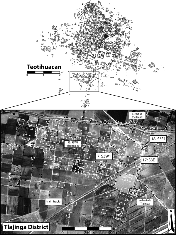
Morning fieldwork at Tlajinga often involves monitoring the hot-air balloons that hover overhead to the north, carrying tourists over the reconstructed pyramids and palatial complexes of Teotihuacan's monumental urban core. The layered distribution of the arc of balloons, Cerro Gordo—the largest mountain in the Teotihuacan Valley—and the Sun and Moon Pyramids all work to pull one's gaze northward, as the last two would have also done during the city's Classic-period occupation (a.d. 1–550). From the vantage of Tlajinga, about 2.5–3 kilometers to the south, the iconic pyramids look decidedly subdued relative to how one experiences them in the tourist zone. It is therefore all the more remarkable that this periphery is still part of the dense urban footprint of the ancient city, with many dozens of closely packed, multifamily apartment compounds buried underfoot. Tlajinga represents the last major cluster of neighborhoods in the southern city and its orthogonally organized expanse of apartments, platform complexes, and plazas cover approximately 1 km2, large enough to constitute a small city in its own right (Figure 1).
Teotihuacan with inset depicting the Tlajinga district and structures mapped from the surface during the Teotihuacan Mapping Project by Millon et al. (Reference Millon, Drewitt and Cowgill1973), and excavation areas at 33:S3W1, 17:S3E1, 18:S3E1, and the Street of the Dead.

Teotihuacan's dense urbanism involving a citywide, grid-like plan stretching to distant peripheries such as Tlajinga was first documented through the efforts of Millon (Reference Millon1973) and colleagues (Millon et al. Reference Millon, Drewitt and Cowgill1973) during the Teotihuacan Mapping Project (TMP). Parts of the district were then investigated by students of William Sanders at Pennsylvania State University, including excavations at one of the apartment compounds, 33:S3W1 or “Tlajinga 33,” overseen by Widmer and Storey (Reference Widmer, Storey, Santley and Hirth1993, Reference Widmer, Storey, Arnauld, Manzanilla and Smith2012; Widmer Reference Widmer, de Tapia and Rattray1987); Storey's (Reference Storey1992) detailed bioarchaeological analysis of human remains from those excavations and Widmer's (Reference Widmer1991) early application of microartifact analysis to understanding lapidary production and consumption patterns; Sheehy's (Reference Sheehy1992) study of pottery production, particularly of the type known as San Martín Orange, in the vicinity of this compound; and Nichols' (Reference Nichols, de Tapia and Rattray1987, Reference Nichols1988) use of infrared aerial photography and targeted excavations to document irrigation canals. New research at Tlajinga presented in this Special Section is highly collaborative and links to earlier research through the participation of Widmer, Storey, Kenneth Hirth, and other students and researchers from Pennsylvania State University. It also incorporates specialists from the Instituto de Investigaciones Antropológicas of the Universidad Autónoma de México (IIA/UNAM), including Luis Barba and team members from the Laboratorio de Prospección Arqueológica and McClung de Tapia (Reference McClung de Tapia2015) and her team's continuation of a sustained program of geoarchaeological and paleobotanical investigations in the valley.
As a district, or barrio, Tlajinga comprises three or four neighborhoods of contiguous apartment compounds with a defined concentration of platform structures running along the western “street front” of the Street of the Dead, a few dispersed platform complexes, and two open areas that likely served as plazas. All of these neighborhood public spaces remain unexcavated at Tlajinga, but the more extensive excavations undertaken by Cabrera Castro and Gómez Chávez (Reference Cabrera Castro, Gómez Chávez, Mastache, Cobean, Cook and Hirth2008; Cabrera Castro Reference Cabrera Castro1996; Gómez Chávez Reference Gómez Chávez, Arnauld, Manzanilla and Smith2012) at La Ventilla and by Manzanilla (Reference Manzanilla, Manzanilla and Chapdelaine2009, Reference Manzanilla, Arnauld, Manzanilla and Smith2012, Reference Manzanilla2015, Reference Manzanilla2017) and colleagues at Teopancazco provide models for neighborhood organization to evaluate through research at Tlajinga. La Ventilla and Teopancazco are both located much closer to Teotihuacan's urban epicenter than is Tlajinga, just southwest and southeast of the monumental core, respectively, and this has important implications for the status of their occupants since Teotihuacan's urban plan presents a strongly concentric organization with higher status and power concentrated in the center (Carballo and Fortenberry Reference Carballo and Fortenberry2015). Nevertheless, the multidisciplinary research at La Ventilla and Teopancazco demonstrate the functional and status diversity that characterized districts and neighborhoods of Teotihuacan, where occupants of differing social status could occupy the same apartment compound, intermediate elites occupying more elaborate residences organized rituals and other public events, and production activities ranged from the crafting of utilitarian goods to highly ornate vestments and adornments. Teotihuacan's well-preserved urban plan invites comparison with textually documented institutions of the later Aztecs, and authors have proposed that well-known Aztec corporate social groups (the calpulli or tlaxilacalli) have origins in the Teotihuacan apartment compounds and neighborhoods, since these feature communal space with central temples or shrines, shared occupational specializations, and internal stratification whereby elites and nonelites could belong to the same group (Fargher et al. Reference Fargher, Blanton, Heredia, Nichols and Rodríguez-Alegría2017; Gómez Chávez Reference Gómez Chávez, Arnauld, Manzanilla and Smith2012).
The articles of this Special Section consider different scales and scopes of analysis based on fieldwork at Tlajinga conducted between 2012–2015 and laboratory analyses that has been ongoing since then. The lead article by David Carballo, Kenneth Hirth, Daniela Hernández Sariñana, Gina Buckley, Andrés Mejía Ramón, and Douglas Kennett establishes the scope of the project and reports on our excavations in two adjacent apartment compounds, designated 17 and 18 of TMP grid-square S3E1. Our primary focus of study is the nature of domestic life for the working-class occupants of the compounds who, similar to their counterparts in 33:S3W1, specialized in the production of utilitarian tools and simpler forms of adornment.
At the broadest scale of both spatial and topical analysis is the geospatial research presented next by Jorge Blancas, Luis Barba, Agustín Ortiz, Guillermo Acosta, Andrés Mejía Ramón, and David Carballo. This facet of the project involved the layered analysis of satellite imagery, topographic mapping by unmanned aerial vehicle (drone) and differential GPS, and subsurface mapping combining geophysical techniques. It reveals spatial patterns at the level of the district and its neighborhoods, showing that, as a whole, Tlajinga possesses a more regular, rectilinear pattern while individual apartment compounds have more irregular footprints than are conveyed through the TMP map. These findings, corroborated by the excavations, help us to refine Millon's (Reference Millon and Wolf1976:217) proposal that on the periphery, “where limitations of space were not a factor, the Teotihuacanos built standard apartment compounds. What apparently was originally designed for crowded urban living evidently came to be regarded by the vast majority as the only way to build, whether one was in the crowded center of the city or on its outskirts.” We document this transition to crowded urban living at Tlajinga, but also that, with more space between compounds than was available in the urban core, the occupants of the district could add to their apartments incrementally as family needs required.
The new research also shows how the occupants of Tlajinga were linked to the rest of the city by the southern extension of the Street of the Dead, the central artery to which the citywide orthogonal plan was tethered. Geoarchaeological investigations presented by Mareike Stahlschmidt, Emily McClung de Tapia, and Maria del Carmen Gutiérrez-Castorena demonstrate how the extension of this unifying urban feature through Tlajinga represents a massive alteration of the indurated volcanic tuft (tepetate) to extend the urban plan southward. In our lead article, we also describe how labor estimates for this landscape modification are suggestive of district-level coordination, whereas excavations along the sides of the Street of the Dead uncovered crude retaining walls, likely built individually by members of apartment compounds and implicating mixed forms of group labor in the city's urban sprawl.
The next three articles focus on excavated materials and comparisons with previous findings from Tlajinga. Rebecca Storey, Gina Buckley, and Douglas Kennett draw direct comparisons between osteological remains from the Proyecto Arqueológico Tlajinga Teotihuacan (PATT) and those excavated earlier at 33:S3E1, including a consideration of migration patterns, status, and diet using bone chemistry. An unexpected finding from their analyses is that individuals identified as higher status based on burial location and furnishings were more likely to have been migrants than those who were identified as lower status. Domestic economies and craft production are covered in the next two articles. Compound 17:S3E1 provides a detailed example of large-scale, domestic obsidian production at Teotihuacan, helping to move past a longstanding stalemate between initial proposals for the organization and scale of obsidian workshops at the city (Santley Reference Santley1980, Reference Santley and Miller1983; Spence Reference Spence1967, Reference Spence1981) and a critique of the criteria used for identifying workshops and estimating their organization and levels of output (Clark Reference Clark and Isaac1986, Reference Clark, Gaxiola G. and Clark1989; see also Andrews Reference Andrews, Hirth and Andrews2002; Carballo Reference Carballo2011). The technological analysis of lithic artifacts by Kenneth Hirth, David Carballo, Mark Dennison, Sean Carr, Sarah Imfeld, and Eric Dyrdahl captures the full sequence of prismatic-blade reduction from large macrocores to products made on fine blades. In situ production is confirmed by excavated caches from Compound 17, an auguring program, and the microdebitage that Stahlschmidt and colleagues found encrusted in the floor of a platform between the compound and the Street of the Dead. Randolph Widmer closes the section by quantifying and considering several classes of microdebitage including obsidian, but also implicating other production activities such as lapidary adornments made from slate. He also highlights contributions to the diet of Tlajinga's residents made by smaller and more ephemeral food remains.
Contributions to the section evaluate changes through time and variability relating to status at Tlajinga, and what these mean for studies of Teotihuacan more broadly. Our initial article presents 29 accelerator mass spectrometry 14C dates, deeper stratigraphic sequences, and a preliminary consideration of the elaboration of architecture and artifacts. Deep excavations in the center of Compound 18:S3E1 revealed a sequence of eight occupation surfaces that began with more simply made structures that were not apartment compounds and their associated hearths. We track the evolution of apartment living in the area and the introduction of ceramic stoves (three-pronged burners) suitable for heating foods without emitting as much smoke. Dates and artifacts indicate that Tlajinga's population became significant in the late Miccaotli phase, beginning in the later second century a.d. Apartment living is first registered sometime in the middle of the Tlamimilolpa phase, and the only dates of the 29 analyzed that extend past the mid-sixth century come from a single intrusive Mazapan-phase burial. This terminus in the sixth century further supports an earlier end to the city than what is still erroneously presented in some secondary literature, whereas the complete lack of any evidence of burning associated with the abandonment of Tlajinga contrasts with patterns from the urban epicenter, whose targeted conflagrations suggest termination by internal agents.
Although the architecture of apartment compounds at Tlajinga indicates lower social status, including walls made from a mix of stone and adobe with minimal use of lime-plaster restricted to courtyards and no evidence of mural painting or roof adornments (almenas), materials recovered through excavations exhibit a population connected to Teotihuacan's urban and interregional economies. This includes the large-scale production of obsidian tools and higher value objects, such as a sculpted stone face and painted-stucco pottery, that demonstrate a level of access to finer goods on the part of lower-status occupants on the urban periphery. It is a level of access that would have been unlike most other parts of Mesoamerica at the time, and surely stands as one of Teotihuacan's great social achievements before its fiery end.
We dedicate this Special Section to the memory of George Cowgill and the enduring legacy he left to studies of Teotihuacan, comparative urbanism, and statistical reasoning in archaeology. George was an extraordinary scholar who was unwavering in his support of continuing research at Teotihuacan, both through his mentorship of junior scholars and his investments in the Arizona State University Teotihuacan Research Laboratory in San Juan Teotihuacan, through which so many projects have been run, including ours. We are tremendously appreciative of his support and for the model he established for critical yet cordial scholarly discourse and collaborative research on this fascinating ancient city.