

Introduction
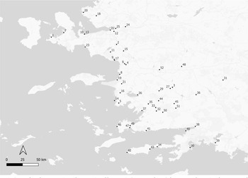
Ionia and Caria are two major ancient cultural regions from the southwest portion of the Anatolian peninsula. In this paper, we present a synthesis of newly published research and recent significant discoveries relating to these regions (Map 5.1). Chronologically, we focus on the Archaic and Classical periods, but we also note significant work relating to prehistoric and post-Classical periods. For Ionia, we focus on mainland Turkey, but, although they were part of Ionia in antiquity, we exclude the islands of Chios and Samos.
Sites referred to in text: 1. Bağlararası; 2. Bakla Tepe; 3. Çine Tepecik; 4. Çukuriçi; 5. Didyma; 6. Ephesos; 7. Erythrai; 8. Kadıkalesi/Anaia; 9. Klaros; 10. Klazomenai; 11. Kolophon; 12. Larissa; 13. Liman Tepe; 14. Melie/Çataltepe; 15. Metropolis; 16. Miletos; 17. Notion; 18. Panaztepe; 19. Panionion/Otomatiktepe; 20. Phokaia; 21. Priene; 22. Smyrna; 23. Teos; 24. Ulucak; 25. Yeşilova; 26. Latmos Herakleia; 27. Alabanda; 28. Alinda; 29. Amos; 30. Aphrodisias; 31. Beçin Kalesi; 32. Burgaz; 33. Datça Apollon Kutsal Alanı; 34. Euromos; 35. Hyllarima/Wallarima; 36. Iasos; 37. İdyma; 38. Kaunos; 39. Kedrai; 40. Kissebükü; 41. Knidos; 42. Labraunda; 43. Lagina; 44. Mastaura; 45. Myndos; 46. Nysa; 47. Pedasa; 48. Sinuri; 49. Stratonikeia; 50. Tralleis; 51. Uzunyuva Hekatomnos.

Southwest Anatolia has been subject to rapid urbanization at an increasing rate since the 1980s, with its coasts an epicentre of tourism that has triggered mass urban development in the area. These conditions inevitably pose a threat to the cultural and natural landscapes of the area, necessitating inventive methods of sustainable conservation. The present socio-political dynamics frame current research strategies, where restoration and sustainable conservation are considered crucial for most archaeological sites. However, huge-budget conservation projects, although providing solutions for well-preserved urban cores and monuments, remain ineffectual for the rural landscapes and settlements lacking monuments. Rescue excavations led by local museums continue at most archaeological sites of long-term established excavations. They are necessitated by new construction projects and yield ample amounts of significant new evidence.
Turkish periodicals including annual reports on research excavations (Kazı Sonuçları Toplantısı), museum studies and rescue excavations (Müze Çalışmaları ve Kurtarma Kazıları), and field surveys (Araştırma Sonuçları Toplantıları) in Turkey are published by the General Directorate of Culture and Museums, Turkish Ministry of Culture and Tourism. These reports are available online (https://kvmgm.ktb.gov.tr/TR-44758/yayinlarimiz.html) and include detailed annual reports for each excavation and survey project.
Ionia
Ionia, located on the western tip of Anatolia, has long been of archaeological interest, particularly owing to the early Ionian expeditions led by the Society of Dilettanti (on which see further below). Following the first official permit given for excavations at Troy in 1871, the excavations in Ionia took place at Priene, with an official permit granted in 1891 to a German team. Archaeological practice in the region has long followed the trajectory of the ‘Great Tradition’, implementing long-term, large-budget excavations, mainly confined to the excavation and restoration of post-Classical sites such as Ephesos, Miletos, Didyma, and Priene.
Owing to the copious amount of ancient textual sources on the history of Ionia, archaeological practice has placed itself within a framework defined by those sources. Its impact as a research area has been limited by those historical legacies, as well as political agendas relating to colonial frameworks, the rise of the nation-state, Westernization, and Anatolianism. Only recently have research agendas shifted from the exploration of well-preserved urban settlements and monumental temples to alternative research areas. Although Ionia was relatively peripheral to the Greek koine, it was the epicentre of the political and social events that shaped ancient Greek civilization, and became an area of major research interest as early as the 18th century. However, this historical legacy came with both advantages and disadvantages. More than just a buffer zone between the Greeks and the ‘East’, Ionia has been regarded as a key region in many respects for defining the plurality of identities in the Aegean and around the Mediterranean during the first millennium BC.
During the last decade, long-term excavations continued in the region at the large urban sites of Ephesos, Miletos, Erythrai, Klazomenai, Teos, Priene, Smyrna, Phokaia, Metropolis, Magnesia, Nif Mountain, Kadıkalesi and Ayasuluk. Several seasons of extensive field survey have been conducted at Lebedos and its environs, but there is currently no systematic excavation project. Urban surveys at Kolophon conducted between 2010 and 2014 and at Notion between 2014 and 2021 (https://sites.lsa.umich.edu/notionsurvey/) yielded significant evidence about the urban core and their close environs. At Notion, excavations began in 2022 as part of a new programme of research. Long-term excavations at two important sanctuaries at Didyma and Klaros have also continued almost without any significant hiatus since the late 1900s.
The settlement history of the region dates back to the Neolithic period (Horejs Reference Horejs and Molloy2016; Çevik Reference Çevik, Sagona, Batmaz, Bedianashvili, Michalewicz and Robinson2018; Maltas et al. Reference Maltas, Şahoğlu, Erkanal and Tuncel2022; Şahoğlu Reference Şahoğlu, Ersoy and Koparal2022), even though the geomorphology of the region, characterized by alluvial deposition and erosion, renders much of the evidence difficult to identify. Although Classical scholarship has long dominated archaeological practice in the region, the last decades have seen an increasing number of excavations at prehistoric sites: Bağlararası (Şahoğlu Reference Şahoğlu, Bingöl, Öztan and Taşkıran2012), Bakla Tepe (Şahoğlu Reference Şahoğlu2016; Aykurt and Erkanal Reference Aykurt and Erkanal2017; Irvine and Erdal Reference Irvine and Erdal2020), Liman Tepe (Şahoğlu et al. Reference Şahoğlu, Erkanal, Gündoğan, Tuğcu, İncirlili, Işıklı, Fidan, Türker and Yılmaz2022a), Çine Tepecik (Günel Reference Günel, Dietz, Mavridis, Tankosic and Takaoğlu2018; Reference Günel, Henry and Belgin-Henry2020), Yeşilova (Derin and Caymaz Reference Derin, Caymaz, Dietz, Mavridis, Tankosıć and Takaoğlu2017), Panaztepe (Erkanal-Öktü and Erkanal Reference Erkanal-Öktü, Erkanal and Yalçın2015; Erkanal-Öktü Reference Erkanal-Öktü2018), Ulucak (Çevik Reference Çevik and Marciniak2019), and Çukuriçi (Horejs Reference Horejs2012; Horejs and Schwall Reference Horejs, Schwall, Dietz, Mavridis, Tankosic and Takaoğlu2017). Among these, underwater archaeological research has been conducted at Liman Tepe, yielding significant evidence about the harbours and maritime networks of this site from the Bronze Age into the Classical period (Erkanal Reference Erkanal, Ladstatter, Pirson and Schmidts2014). Field surveys conducted in the region have also documented several new prehistoric sites. Between 2006 and 2021, the Klazomenai Survey Project (KLASP; https://www.klasp.net) conducting field surveys on the Urla-Çeşme peninsula recorded 39 prehistoric sites, 13 of which are dated to the Late Neolithic period (Koparal et al. Reference Koparal, Ersoy, Massa, Demirciler, Steadman and McMahon2017). Between 2015 and 2021, the Karaburun Archaeological Survey Project (KAYA) working on the Karaburun peninsula (https://karaburunyuzey.wordpress.com) discovered two possible upper Palaeolithic sites (Çilingiroğlu and Dinçer Reference Çilingiroğlu and Dinçer2021).
An effervescence of new archaeological field surveys has also greatly shaped our perception of Ionian landscapes in recent years. In the 1980s and 1990s, pioneers Numan Tuna, Recep Meriç, and Hayat Erkanal, inspired by the ‘new wave’ of surveys emerging in Greece (Knodell et al. Reference Knodell, Wilkinson, Leppard and Orengo2022), conducted extensive surveys and recorded archaeological sites outside of urban cores, displaying admirable energy towards the preservation of cultural landscapes. Recently, field surveys employing systematic and intensive survey methods based on the traditional Mediterranean survey model have brought a new holistic dimension to defining the khorai and territories around urban cores. The Milesian territory survey (Lohmann Reference Lohmann and Cobet2007) can be regarded as a pioneer project for its systematic exploration of polis territories. The most outstanding result from Lohmann’s survey is the possible identification of the sites of Melie and the Panionion (Herda Reference Herda2006; Lohmann Reference Lohmann2013).
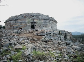
Recently, although small in number, survey projects with a landscape perspective have revealed that urban centres and monumental temples were not the only important sites on the Ionian landscape – they were enmeshed with a network of villages, hamlets, farmsteads, watchtowers, forts, and rural cult centres. The Urla-Çeşme Peninsula Survey (KLASP; Koparal et al. Reference Koparal, Ersoy, Massa, Demirciler, Steadman and McMahon2017) and the Panormos Survey (https://www.panormos.de/pp/survey/) (Wilkinson and Slawisch 2017; Reference Wilkinson and Slawisch2019) are regional long-term projects that have recorded rural landscapes and their features diachronically around the polis settlements of Klazomenai, Teos, Erythrai, and Miletos. These projects have opened up a new direction for the diachronic documentation of rural landscapes around the Ionian poleis and for defining settlement systems in khorai. Both projects have placed particular emphasis on agro-pastoral patterns and rural production, and the management and conservation of rural landscapes (Wilkinson and Slawisch Reference Wilkinson and Slawisch2020; Turner et al. Reference Turner, Kinnaird, Koparal, Lekakis and Sevara2021a; 2021b; Koparal, Demirciler and Turner Reference Koparal, Demirciler and Turner2022). The Panormos project has also made use of satellite and aerial images for mapping linear landscape features in defining agro-economic field systems for the Milesian peninsula (Wilkinson and Slawisch Reference Wilkinson and Slawisch2020). The KLASP project, covering the territories of Klazomenai, Erythrai, Teos, and Lebedos, has recorded more than 500 rural sites, forts, watchposts, shrines, and other types of landscape features such as paths, tumuli, and terraces (Koparal et al. Reference Koparal, Ersoy, Massa, Demirciler, Steadman and McMahon2017). The localization of two rural temples at the fringes of the Klazomenaian territory (Fig. 5.1 ) has also been significant for defining the organization of polis territories (Koparal Reference Koparal, Engels, Huy and Steitler2019). Detailed study of the formation sequences of terrace systems and OSL dates obtained from construction deposits has dated the terraces located during survey around Klazomenai to the Middle Ages onwards (1340 ± 140 CE) (Turner et al. Reference Turner, Kinnaird, Varinlioğlu, Şerifoğlu, Koparal, Demirciler, Athanasoulis, Ødegård, Crow, Jackson, Bolòs, Sánchez-Pardo, Sanderson and Turner2021b; Koparal, Demirciler and Turner Reference Koparal, Demirciler and Turner2022). However, the latest regulations issued by the Turkish Ministry of Culture and Tourism regarding the transportation and study of archaeological material have prevented the organic materials from being taken outside the country for study, a factor that has had a direct impact on the original research design of the project.
Klazomenai khora, Aphrodite temple, kore statue, and architectural fragments.© KLASP.

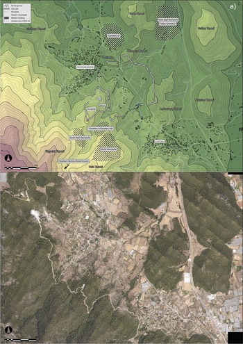
Field surveys conducted at urban centres have applied advanced methods for the documentation of urban patterns making use of remote sensing technologies and geophysics. The Kolophon survey project conducted between 2011 and 2014 covered the urban core and its close environs (Fig. 5.2), using pedestrian survey as well as remote sensing, particularly LiDAR imaging and geophysics (Bruns-Özgan, Gassner and Muss Reference Bruns-Özgan, Gassner and Muss2011; Muss et al. Reference Muss, Gassner, Grammer and Gretscher2014; Grammer et al. Reference Grammer, Draganits, Gretscher and Muss2017). The main outcome of this research is that the exact extent of the necropolises can now be determined. Legacy data from the 1920s has been reassessed, too, wherein Mariaud’s work on Geometric graves has shed new light on burial customs in early Ionia (Mariaud Reference Mariaud and Mazarakis Ainian2011). The survey based on the LiDAR scan facilitated the discovery of the burial grounds to the south of Kolophon in the urban area. Urban surveys conducted at Notion (Fig. 5.3) (Ratté, Rojas and Commito Reference Ratté, Rojas and Commito2020), Larissa (Külekçi and Saner Reference Külekçi and Saner2022), and Miletos (Huy and Weissova Reference Huy and Weissova2020) have recorded urban patterns in detail by making use of intensive survey methods, remote sensing and digital architectural documentation techniques.
Kolophon LiDAR images and urban layout plan. © Benedikt Grammer.

Notion aerial image or plan. © Notion Excavations.

For summaries of the general archaeological evidence of the whole region, the proceedings of the Panionion symposium held at Güzelçamlı in 1999 and published in 2007 is still one of the most up to date syntheses on Ionia (Cobet Reference Cobet2007). Very recently, Yapı Kredi Yayınları in collaboration with Tüpraş published Ionians: The Sages of the Aegean Shore (Ersoy and Koparal Reference Ersoy and Koparal2022), a comprehensive review of the archaeology of Ionia and the 11th book in the special series ‘Anatolian Civilizations’. Proceedings of the international symposium ‘Ionians in the East and West’ included 34 articles on literary sources, material analysis, ethnicity, and identity by placing the region in a broader geographical context and discussing its interactions with the rest of the Mediterranean (Tsetskhladze Reference Tsetskhladze2022).
For syntheses of archaeological work with a more defined chronological range, Alan Greaves’ The Land of Ionia: Society and Economy in the Archaic Period focuses on the Archaic period, bringing a critical approach to the practice and methodologies used in Ionian archaeology (Greaves Reference Greaves2010; cf. Lemos Reference Lemos2007; Crielaard Reference Crielaard, Derks and Roymans2009; Mac Sweeney Reference Mac Sweeney2013). Greaves placed Ionian archaeology in a broader context and called for archaeological practice in Ionia to be integrated more closely with archaeological theory. New work on the Classical period has also recently been published. Accustomed to Obedience? Classical Ionia and the Aegean World, 480–294 BCE (Nudell Reference Nudell2023) presents a narrative of Ionia for the period between the Persian Wars and the wars of the Early Hellenistic period, focusing on local interactions and consciously evading an Atheno-centric approach. Anja Slawisch has also presented a detailed synthesis of the same era (Slawisch Reference Slawisch, Ersoy and Koparal2022) by bringing together material culture and literary evidence.
In the last two decades, new data from the archaeology of Ionia has been integrated into significant and exciting debates on the ‘Ionian Migration’. For example, in the proceedings of Nostoi: Indigenous Culture, Migration and Integration (Stampolidis, Maner and Kopanias Reference Stampolidis, Maner and Kopanias2015), the Ionian Migration is discussed with regard to material analysis (Vaessen Reference Vaessen2015) and textual evidence (Fragkopoulou Reference Fragkopoulou, Stampolidis, Maner and Kopanias2015; Mac Sweeney Reference Mac Sweeney, Stampolidis, Maner and Kopanias2015). A forthcoming volume based on the 2021 symposium ‘Western Anatolia in the Second Millennium BCE: Recent Developments and Future Prospects (WANAT)’ will also include several papers discussing the Ionian Migration and early Ionian archaeology. Elsewhere, Vaessen has presented an overview of the Ionian Migration discourse and discussed how it was used until recent centuries in the contexts of colonialism and westernization (Vaessen Reference Vaessen2018). Mac Sweeney has examined the foundation myths of Ionian poleis, discussing the assumed cultural differences and ethnic diversities in the Archaic and Classical periods (Mac Sweeney Reference Mac Sweeney2013). Another recent article by Mac Sweeney discusses Greek regional identities with reference to Ionians and their collectivity during the Archaic and Classical periods (Mac Sweeney Reference Mac Sweeney2021).
Regarding the place of Ionian archaeology in broader dialogues about regional cultural history, remains of the Ionian poleis and temples have long captured the imagination of those working and travelling in the region, with some of the first extensive English-language written accounts already appearing by the end of the 18th century (Chandler Reference Chandler1775; Diaz-Andreu Reference Diaz-Andreu2007; Koparal Reference Koparal2020). The huge legacy of travellers and early researchers in Ionia, particularly those from the Dilettanti society, provides one of the most exciting emergent research areas, and the historiography of research in Ionia has been well discussed in recent years (Lekakis Reference Lekakis2018; Tanyeri-Demir Reference Tanyeri-Demir, Ersoy and Koparal2022; Tiberius Reference Tiberius2023). In May 2021, an exhibition on the Ionian expedition of the Dilettanti Society took place at the Sir John Soane Museum at London (https://www.soane.org/exhibitions/romance-ruins-search-ancient-ionia-1764).
New discoveries from excavations at urban sites
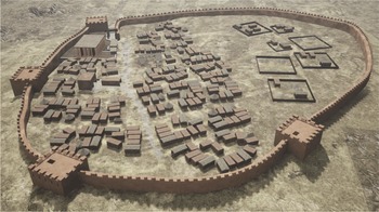
Excavations at the Bayraklı Höyük of Old Smyrna yielded new evidence concerning the mudbrick defence wall dated to the mid-eighth century BC and known to be the earliest of the Ionian poleis (Fig. 5.4). The wall has four main building phases, the latest of which is in the Late Classical period that hallmarks the abandonment of the settlement. Research on the mudbrick defence wall of Old Smyrna was first initiated in 1948–51, but it produced new questions and various issues have remained unsolved until now. In 2016 a new research project focusing on the ancient defensive structures made use of updated data from the old trenches and their stratigraphy. New excavations at previously opened trenches revealed the remains of the first phase of the wall mentioned by Nicholls (Reference Nicholls1958/1959). These remains are dated to the mid-ninth century BC on the basis of pottery finds (Cevizoğlu and Tanrıver Reference Cevizoğlu and Tanrıver2023). Since 2017 the western trenches of Old Smyrna have yielded significant evidence for continuous habitation from the Early Bronze Age. Sherds of anthropomorphic vessels found in those contexts are dated from the Early to Middle Bronze Age (Eroğlu and Erdem Reference Eroğlu and Erdem2022). A hoard of silver jewellery unearthed at the settlement mound was found in an in situ jar and dated to the Early Bronze Age, underlining the significance of Smyrna during this period (Erdem Reference Erdem2022). Thus, along with Klazomenai, Old Smyrna is an important Ionian settlement that exhibits settlement continuity between the Early Bronze Age and Classical periods. Excavations at the Hellenistic and Roman agora have shed light on the later history of Smyrna through material analysis including glass and metal finds, and Hellenistic pottery (Frasca, Ersoy and Aydemir Reference Frasca, Ersoy and Aydemir2016).
Smyrna mudbrick wall 3D modelling image. © Bayraklı Smyrna Kazı Başkanlığı.

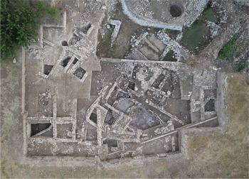
Klazomenai is one of the key sites in the region for understanding the transition from Late Bronze Age to Early Iron Age. The site, located at İskele of Urla, has revealed diachronic urban development from the Early Bronze Age to the Late Classical period. The remains of the Early Iron Age settlement on the southern slopes of Liman Tepe have revealed evidence for a continuous habitation from the 11th century BC to the fourth century BC (Ersoy Reference Ersoy2014). Along with surveys of the territory, excavations have produced useful evidence to shed light on the dynamics of the era. The most intact evidence of the Late Bronze Age/Early Iron Age transition comes from Klazomenai Kaya Elmalı Tarlası sector (Fig. 5.5 ), where an apsidal building with several phases is situated (Ersoy Reference Ersoy2022). Koparal and Vaessen have integrated survey data with excavation data to discuss regional networks and settlement patterns around Klazomenai from the Late Bronze Age to Iron Age, arguing that there was a web of relations in which Klazomenai found itself entangled during the Early Iron Age (Koparal and Vaessen Reference Koparal and Vaessen2020). A regional synthesis on the Early Iron Age of Ionia has been established by integrating data from Klazomenai with the fragmentary data from other sites across the region, including Miletos and cult places Ephesos Artemision, Klaros Apollon and Chios Kato Phana (Ersoy and Vaessen Reference Ersoy, Vaessen, Ersoy and Koparal2022).
Klazomenai Early Iron Age building aerial image. © Klazomenai Excavations.

Near Smyrna, the Nif Dağı project, continuing since 1999, is producing diachronic evidence for production technologies (Baykan Reference Baykan2016), and has revealed settlement quarters and burial grounds dated from the eighth century BC to the 14th century AD (Tulunay Reference Tulunay2014).
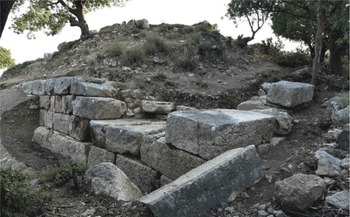
The excavations at Teos were initiated following architectural documentation carried out by METU TAÇDAM and intensive surveys conducted by the KLASP project (Koparal and Tuna Reference Koparal and Tuna2017); the new programme of work focused mainly on the Hellenistic city wall (Fig. 5.6 ), the Dionysos temple, and the harbour area (Kadıoğlu Reference Kadıoğlu2020). Recent epigraphic research at Teos has focused on the discovery of an inscription quoting Teian support of the Abderans to rebuild their cities in 170 BC after the Roman sack: this research has now been published in a volume that covers the history of the long-term relation between two cities from the Archaic to Hellenistic period (Adak and Thonemann Reference Adak and Thonemann2022).
Teos city walls. © Teos Excavations.

Erythrai is a difficult site to investigate in Ionia due to a significant part of the ancient settlement lying below the modern settlement. Excavations initiated in 2007 have focused on several different areas including the Cennettepe Roman settlement, theatre, Heraklion, and Banyoztepe. Research has indicated that the limits of the Archaic settlement were bounded by Heraklion on Değirmentepe hill, together with the production quarters at Banyoztepe. Remains of a bastion and layers from the Early Bronze Age unearthed at Cennet Tepe constitute important discoveries for the early history of the settlement (Şahoğlu Reference Şahoğlu, Ersoy and Koparal2022). Research on cult practices and new data deriving from extra-urban cult places present valuable insights about cult practices performed by Erythraeans in reverence to the goddess Demeter (Akalın Reference Akalın, Kaya and Sina2012; Gençler-Güray Reference Gençler-Güray2018).
Research at Miletos has focused on the urban layout of the settlement. Urban survey at Humeitepe (Huy and Weissova Reference Huy and Weissova2020) produced significant evidence, adding to the picture of decades of archaeological research at Humeitepe that have previously revealed a multiple layered urban pattern, including insulae, two thermae, a harbour, and the Demeter sanctuary. Intensive surveys employed pottery analysis to provide a more structured, precise, and detailed chronology of these well-known spaces. Furthermore, recent work on the street systems to the north of the settlement has put into question the dating of the Hippodamic plan, with scholars arguing for the need to reconsider the possibility that the grid was planned much later in the Classical period than has been previously assumed (Cevizoğlu Reference Cevizoğlu, Ersoy and Koparal2022).
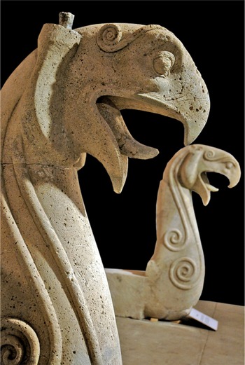
Excavations at Phokaia have mainly focused on architectural documentation and restoration of the city walls and Athena Temple. The defensive wall, as mentioned by Herodotus (I.163.4), surrounded the Archaic settlement and has been found to extend from the peninsula towards the mainland (Özyiğit 2017). The architectural sculptures found at the Athena Temple depicting griffin and horse protomes (Fig. 5.7 ) represent a local tradition of monumental architecture and sculpture (Özyiğit 2020).
Phokaia Athena Temple, horse and griphon protomes. © Prof. Ömer Özyiğit.

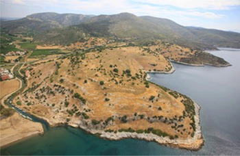
An Archaic cemetery discovered at the ancient harbour of Didyma, Panormos (Fig. 5.8 ), in 2011 was excavated by the local museum in collaboration with German Archaeological Institute in Istanbul (Slawisch Reference Slawisch2014). Initiated as a rescue excavation in three seasons between 2012 and 2014, significant results came to light: burials at the cemetery included both cremation and inhumations, accompanied with burial goods originating from Etruria, Corinth, Athens, Egypt, and Cyprus, indicative of a wide cultural network across the Mediterranean. The necropolis was used from the middle of the seventh until the late sixth century BC. Anthropological and isotope analysis have also been applied: the results indicate a great diversity in diet, suggesting that some of the individuals buried at Panormos might have been raised in other places around the Aegean, or from the interior of Asia Minor. This diversity may be deriving from a high degree of mobility or distinct dietary patterns in juvenility. The situation of the cemetery is particularly interesting given the context of the necropolis in the vicinity of a harbour, providing much opportunity for plugging the site into broader Archaic maritime networks.
Panormos Archaic cemetery. © Dr Anja Slawisch/DAI.

In 2016, due to diplomatic tensions between Austria and Turkey, excavations in Ephesos (where the Austrian research team held the excavation permit) were temporarily interrupted, but have fortunately now resumed. Recent research has mainly focused on the Late Antique phases of the settlement, the Byzantine quarter and Roman gymnasium. Kerschner has also published a comprehensive analysis of the urban layout at Ephesos during the Early Iron Age (Kerschner Reference Kerschner2017). Excavations at the Artemision have revealed two layers that cannot be affiliated with any architecture below the peripteral temple. The earliest of these layers included Late Bronze Age material suggestive of cult use in the area from this period. This layer is sealed with a thin burned layer and, above the Early Iron Age layers, included decorated pottery and figurines from the eleventh to ninth century BC found together with burned animal bones (Forstenpointer, Kerschner and Muss Reference Forstenpointer, Kerschner, Muss and Muss2008; Kerschner Reference Kerschner, Ersoy and Koparal2022).
Excavations at Priene have focused on the agora, sacred stoa, and eastern necropolis chapel, as well as on the architectural documentation of the northern insulae (Mert Reference Mert2020). The rock-cut tombs reveal a continuity from the Hellenistic period to Roman era. Spatial analysis of the cemetery layout also implied that the monumental tombs from the Roman period were in distinct areas, separate to those from the Hellenistic period.
At Klaros, recent excavations have revealed layers below the Archaic altar which lie directly upon the bedrock. Pottery sherds from this context have been found along with charcoal ash and bones, dating to the second half of the 11th century BC. A round-planned structure in the sanctuary included a layer dated between the eleventh century and seventh century and contained metal artefacts, terracotta figurines of bulls and horses, and animal bones (Zunal Reference Zunal2016; Akar-Tanrıver Reference Akar-Tanrıver, Ersoy and Koparal2022).
A history of previous research at Magnesia on the Meander has recently been compiled by Görkem Kökdemir (Reference Kökdemir2015). The latest outstanding discoveries at the settlement include the gate of the Zeus temple, investigated in 2021 and dated to the third century BC. This structure indicates that there was a second important cult figure in Magnesia after Artemis.
Research and conservation continue at the Hellenistic city of Metropolis. The location of Puranda, an Arzawa settlement, with Bademgediği remains a hotly-contested issue in the early history of the region (Meriç and Öz Reference Meriç, Öz, Stampolidis, Maner and Kopanias2015).
Environmental research
Within Ionia, environmental research focusing on the palaeogeographies of the region has accelerated in recent years. The research questions concern mainly delta progradation and changes in coastlines between antiquity and the present day. Given that most settlements were founded on the coastline and near watercourses, these research themes are crucial for defining the palaeoenvironments of ancient landscapes. Major research projects have been undertaken around Ephesos and Miletos in the Mender valley (Brückner Reference Brückner, Kuzucuoğlu, Çiner and Kazancı2019) and at Smyrna (Kayan and Öner 2013) with a view to assessing the impact of Holocene sea level changes in the Aegean (Kayan Reference Kayan2019), concerning geomorphological changes of the coastal environment. These towns were established and developed as major harbour cities, with evidence of delta progradation as suggested by sedimentological, palaeontological, and chronological data collected since the 1980s. This long-term research revealed that the coastline was 40km further inland in Meander valley and 18km in Cayster 6000 BP. The latest important results concerning the archaeobotany of the region come from Liman Tepe (Maltas, Şahoğlu and Erkanal Reference Maltas, Şahoğlu and Erkanal2023). Research focused on the way in which societies adapted agricultural practices to survive the Mid to Late Holocene transition, understood on the basis of stable isotope analysis of archaeobotanical remains from the Aegean region of western Turkey.
Lacustrine sediments from Lake Belevi near Ephesos have been analysed and the study of Holocene deposits has revealed the impact of agricultural activities since 8000 BP on natural vegetation biodiversity and deforestation (Stock et al. Reference Stock, Laermanns, Pint, Knipping, Wulf, Hassl, Heiss, Ladstätter, Opitz, Schwaiger and Brückner2020). Furthermore, tephra from the Thera eruption has been identified in the environs of Ephesos, with similar evidence at Bağlararası (Şahoğlu et al. Reference Şahoğlu, Sterba, Katz, Çayır, Gan, Tyuleneva and Tugcu2022b). Analysis of the remains showed that the site was hit by a series of tsunamis and left a thick layer of debris. In 2013, evidence from Tavşan Adası was also discussed in the context of environmental and socio-ecological changes caused by the Thera eruption (Bertemes Reference Bertemes, Meller and Bertemes2013).
Caria
Caria, encompassing the well-preserved urban centres and monumental buildings of Aphrodisias, Labraunda, Iasos, Kaunos, and Knidos, is a region that, until recent decades, was relatively less explored within Anatolian archaeology. Until recently, the previous focus in Carian research was on the Hekatomnos period and its aftermath, where most of the scholarly energy was on the history between the Late Classical and Roman Imperial periods. But in the last two decades, the focus has shifted to the earlier history of Caria. In particular, significant research on Carian language and its relation to Anatolian Bronze Age languages has opened up new directions in Carian archaeology (Adiego Reference Adiego2007).
New fieldwork has included both the survey of territories and rural landscapes as well as the excavation of sites without monumental buildings. In recent years the number of excavations in the region (such as at Pedasa, Euromos, Sinuri, Heracleia under Latmus) has increased dramatically, where the main output of these projects is new data on pre-Classical Caria. Field surveys also germinated new research agendas for understanding the palaeogeographies of large settlements like Aphrodisias, Labraunda, Stratonikeia, and Euromos that have been excavated for long years (Ratté and De Staebler Reference Ratté and De Staebler2012; Söğüt Reference Söğüt2016).
Monumental tombs and regional burial customs are fundamental to the research undertaken in Caria. The Mausoleion at Halikarnassos is generally regarded as the most prominent example of monumental tombs in the region; but in the last decade, the Uzunyuva Hekatomnos tomb revealed by illicit digs has drawn the attention of scholars and the public, opening a new direction of research concerning the monumental tomb tradition in the region. The most comprehensive published work on the tomb is by Adnan Diler (Reference Diler2020a) and includes the most recent research articles on the subject. Other key volumes include Die Versinschrift des Hyssaldomos und die Inschriften von Uzunyuva (Milas/Mylasa) (Marek and Zingg Reference Marek and Zingg2018) and Die Wandmalereien in der Grabkammer des Hekatomneions. Beobachtungen zu Figurentypen, zur Komposition, Ikonographie und zum Stil (Işık Reference Işık2019), both discussing the inscriptions and wall paintings of the tomb. The general assessment of burial customs of the region have already been covered by Tombes de Carie: Architecture funéraire et culture carienne, VIe-IIe s. av. J.-C. (Henry Reference Henry2009) and subsequently in Death and Burial in Karia (Mortensen and Poulsen Reference Mortensen and Poulsen2016) and Tombs and Burial Customs in the Hellenistic Karia (Nováková Reference Nováková2016).
Long-term excavations at Labraunda, Aphrodisias, and Iasos, as well as the relatively new excavation project at Stratonikeia (initiated 2008) have been published. Publications by Blid on Late Antiquity (2016) and by Hellström on monumental buildings (2019b) are two of the most recent publications of Labraunda, presenting comprehensive research, respectively, on the transformation of the sanctuary in Late Antiquity and on andrones. Data from Aphrodisias have been published extensively, with many new volumes appearing in the main excavation series and relating to general study and discussion. Sculpture studies and monographs concerning the city’s civic buildings occupy an important place among publications: recent publications include detailed research on the Roman Sebasteion, built in 20–60 AD, considering how the monument served the needs of both the cult of Aphrodite and the imperial cult, and exploring its anastylosis; and research on the theatre, the basilica, and on the columned sarcophagi found around the city wall and various parts of the town (Smith Reference Smith2013; Stinson Reference Stinson2016; de Chaisemartin and Theodorescu Reference de Chaisemartin and Theodorescu2017; Öğüş Reference Öğüş2018; van Voorhis Reference van Voorhis2018; Berenfeld Reference Berenfeld2019). Other publications from Aphrodisias include studies on settlement history and the regional survey results (Ratté and De Staebler Reference Ratté and De Staebler2012; Smith et al. Reference Smith, Lenaghan, Sokolicek and Welch2016; Hugh Reference Hugh2022).
Iasos has also been recently published on the city’s fortifications (Cornetti Reference Cornetti2018), and Halikarnassos, the site of the region investigated for the longest time, has received recent attention in Hoepfner’s book (2013). Finally, the results of the field surveys at Loryma and Bybassos have been covered by Held (Reference Held2019).
In general, a more scientific interest towards Caria goes back to 2005 and a symposium held at Berlin, the proceedings of which were published as Die Karer und die Anderen (Rumscheid Reference Rumscheid2009). The flurry of scholarly interest continued thereafter with the publication of Hellenistic Caria (van Bremen and Carbon Reference van Bremen and Carbon2010), the proceedings of a symposium held at Oxford in 2006, and The Carian Language (Adieogo Reference Adiego2007), both of which triggered more interest into the early history of the region. New research particularly focused on the sea routes that connected Caria to the rest of the Mediterranean (Unwin Reference Unwin2017; Poulsen, Pedersen and Lund Reference Poulsen, Pedersen and Lund2021). The Carians: from seafarers to city builders (Belgin-Henry and Henry Reference Belgin-Henry and Henry2020) is the most recent and comprehensive book presenting an overview of archaeological and historical research on Caria from the very first occupations in the prehistoric times to the Late Ottoman period. One of the main subjects covered by this book is the prosperity achieved in the Classical period under the reign of Hekatomnids, and the reflection of this prosperity in the material culture. The other two significant subjects covered by the book are the old cult places revived under the Roman rule and the Late Antiquity of the region.
The pre-Classical period of the region has been covered comprehensively in Karia Arkhaia: La Carie, des origines à la période pré-hékatomnide (Henry and Konuk Reference Henry and Konuk2019), the proceedings of a symposium organized under the same name. This volume covered the Geometric and Archaic periods of Euromos, Kaunos, Iasos, Pidasa, Pedasa/sos, Beçin, and Myndos as well as Mylasa and Labraunda. 4th century Karia: Defining a Karian identity under the Hekatomnids (Henry Reference Henry2013) presented new perspectives on the region by focusing on shifting theoretical approaches. It aimed to bring into question the development of a Carian identity, considering also how Caria achieved political power in Anatolia after the fourth century BC. Synthesis of material culture was the core of the debate, as were a number of articles examining interactions of Caria with Ionia.
Indeed, recent trends in scientific analysis have been used to put Caria into a wider geographical context, by defining interactions with other cultural regions. Under this framework, Euploia : la Lycie et la Carie antiques : dynamiques des territoires, échanges et identités : actes du colloque de Bordeaux, 5, 6 et 7 novembre 2009 (Brun et al. Reference Brun, Cavalier, Konuk and Prost2013) was a pioneer publication for considering regional analysis on the mutual interactions between Lycia and Caria, as well as for considering their supra-regional connectivity and wider networks. Similar in scope (but focused on different regions) for their maritime interactions with Caria were Caria and Crete in Antiquity: Cultural Interaction Between Anatolia and the Aegean (Unwin Reference Unwin2017) and Karia and the Dodekanese: Cultural Interrelations in the Southeast Aegean (Poulsen, Pedersen, and Lund Reference Poulsen, Pedersen and Lund2021), the latter of which consisted of two volumes. The first volume covers the Late Classical to Early Hellenistic periods of Caria and puts particular emphasis on historical and geographical connectivity between Caria and Rhodes, Kos, and Dodecanese. It also presents new research on Halikarnassos. The second volume covers the Early Hellenistic through to Early Byzantine periods, presenting further research from Rhodes, Knidos, and Kos.
Recent publications in Turkish on the archaeology of the region include a new archaeological guide of Knidos (Doksanaltı, Karaoğlan and Tozluca Reference Doksanaltı, Karaoğlan and Tozluca2018), and also a book series summarizing the recent work in Stratonikeia: this series is focused particularly on the different necropoleis and sanctuaries discovered around the settlement, and also on the architectural and sculptural finds from the city centre (Söğüt 2016; Reference Söğüt2019a; Reference Söğüt2019b; Tamsü Polat Reference Tamsü Polat2017; Söğüt and Bilgin Reference Söğüt and Bilgin2019; Söğüt and Pazarcı Reference Söğüt and Pazarcı2019; Söğüt and Gümeli Reference Söğüt and Gümeli2021; Özdemir Reference Özdemir2023).
New discoveries
The pace of archaeological research continues to increase in Caria, enriched both by field surveys and by new discoveries. Located on the southwestern part of the Anatolian peninsula, Caria has a complex topographic location structured by both mountain ranges and river valleys opening up towards the seashore, and a coastline hosting numerous islands close by. This complex web of corridors offered an artery into the highlands of Anatolia, while its connections to the sea routes situated the region at the crossroads of many cultural interactions from the Bronze Age onwards. New research strategies focused on understanding the growing occupation of Caria, especially in the second millennium BC, have concentrated on several attestations in Hittite documents.
Another important research target is to increase knowledge about the Iron Age and Archaic periods of the region. New projects provide important information about the vernacular architecture and the material culture of these periods. Another important contribution of recent studies brings to light the Late Antique period of the region, and also considers the transformations provided by the emergence and later dominance of the region by Christianity. But, overall, one should note that the main research questions proliferating in Caria remain focused on the Hekatomnid and Imperial Roman periods, while most of the excavation strategies undertaken are directed towards investigating the monumental remains of the region’s important cities and cult centres.
As noted above, Iasos, Knidos, Kaunos, and Aphrodisias are long-term established excavations focused on the urban cores, and Labraunda (Fig. 5.9 ) is a major cult centre excavation producing new evidence. However, there are also significant archaeological sites in Caria, such as Pedasa or Alinda, only now being explored for the first time. The last decade has seen the beginning of new excavation and survey projects at Alabanda, Alinda, Euromos, Lagina, Myndos, Stratonikeia, and Tralleis. Excavations at the Gerkakome sanctuary at Latmos Herakleia was also initiated respectively in 2020 and 2021 following promising results generated during intensive field surveys (Peschlow-Bindokat Reference Peschlow-Bindokat2005; Held Reference Held2008), and, likewise, there is a new excavation at Amos emerging from the Rhodian Peraia field surveys. Another field survey project led by Volkan Demirciler focused on the agricultural potential of Hygassos and the environs at the Rhodian Peraia (Oğuz-Kırca, Liritzis and Demirciler Reference Oğuz-Kırca, Liritzis and Demirciler2019). This project recently expanded to cover the Bozburun peninsula and aimed at understanding more about agricultural organization in the region from the Early Iron Age to Late Antiquity. Another significant new multidisciplinary project entitled Phoenix and led by Asil Yaman (https://www.phoenixprojesi.com/en/homepage/) aims to bring together scholars from various areas including archaeometry, history, sociology, philosophy, and geology. Since 2021 the team has explored the Phoenix settlement and its environs diachronically. Archaeological surveys have been integrated with oral history and sociological research to examine the relationship between individuals, institutions, and communities within the modern districts surrounding the ancient settlement.
Labraunda east and south stoa; East church. © Prof. Olivier Henry.

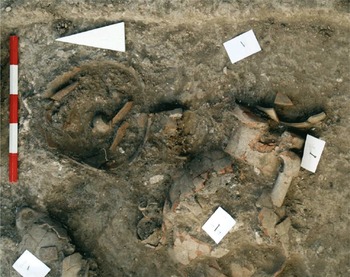
As in Ionia, the early (pre-Archaic) history of Caria is a significant research subject. The Pedasa project is a particular pioneer of this research trend, where excavations have revealed traces of human habitation dated from the 12th century BC, indicating that the settlement was interacting with wider Mediterranean networks since the Geometric period on the basis of pottery found in tombs (Fig. 5.10 ) (Özer Reference Özer2017). Excavations initiated at Sinuri in 2022 have revealed an Archaic sanctuary, which was first discovered 80 years ago. Field surveys covering the territories of Loryma and Bybassos at Carian Chersonessos recorded an early Archaic sanctuary at Asartepe. Research projects at Bodrum peninsula, Damlıboğaz, Sarıçay Plain, Pilavtepe, Kissebükü, and Kedrai focus on Lelegian settlement. In this context, excavations initiated recently at Hyllarima have great potential for identifying the site known as Wallarima, mentioned in Hittite texts.
Pedasa tombs. © Prof. Adnan Diler.

Although the Pedasa excavations have primarily focused at the Athena sanctuary and the acropolis walls, initially concentrating on the Geometric and Archaic periods owing to the dating of the aforementioned structures; further research at the site has located farmsteads and rural houses around the urban core dating from the twelfth to sixth century BC. Among those, round-planned Lelegian farm houses with dry stone walls display very rare examples of well-preserved Iron Age vernacular architecture in Caria (Diler Reference Diler, Henry and Belgin-Henry2020b).
Excavations at the Labraunda sanctuary have revealed that cult practices were performed as early as the sixth century BC, with activities taking place at the in-antis temple and altar, both placed on a terrace with propylon (Hellström Reference Hellström, Henry and Konuk2019a).
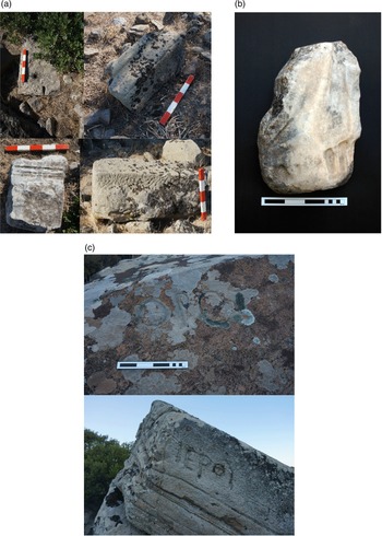
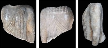
Research combining excavation and field survey at Euromos has documented necropoleis and watchtowers around the settlement centre and presents a holistic view of the town. Two Archaic kouroi (Fig. 5.11 ) found at the southern edge of the Zeus Leposynos temple are particularly significant discoveries. One of the kouroi bears a lion on his chest and is accompanied with a four-lined Carian inscription dated to the second half of the sixth century BC. The inscription could not be deciphered, but is of great interest with regard to the evolution of the Carian alphabet (Kızıl and Adiego Reference Kızıl and Adiego2021).
Euromos Archaic kouros: a) torso, frontal view, b) torso, back view, c) torso, left profile. © Prof. Suat Ateşlier.

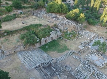
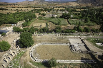
Excavations in the south agora at Aphrodisias (Fig. 5.12 ) have focused on the city’s second public square. The agora comprises a long colonnaded piazza (215 × 70m) with a monumental water-basin (170 × 30m) situated in the centre of the square. Meticulous and comprehensive archaeological research has revealed that this pool was flanked by palm trees, and that the whole complex was a kind of urban park familiar from similar complexes or porticoes in Early Imperial Rome (Smith Reference Smith, Henry and Belgin-Henry2020). The results of the excavation project will be published soon by Andrew Wilson and Ben Russell in The Place of Palms: An Urban Park at Aphrodisas.
Aphrodisias south agora and aerial image of the pool. © Prof. R.R.R. Smith.

Other remarkable discoveries come from Kaunos, where the research programme focuses on the Apollo and Aphrodite sanctuaries, the Dionysos temple, and an underwater excavation at the Leto cult place at Sultaniye. A marble statue of Artemis Eleuthera (end of second century BC), found in the rock-cut room at the centre of a building and situated on the northern end of the Apollon sanctuary (presumably used for feasting) is the earliest representation of the numinous goddess at Lykia (Işık Reference Işık, Henry and Belgin-Henry2020).
Finally, perhaps the most fascinating discovery of the last decades in Caria is the Hekatomnos monumental tomb, which, as mentioned above, was revealed by illicit digs. It is understood that the tomb was known to treasure hunters since 2005, but since 2010 it has been studied archaeologically. The tomb is a monumental construction placed upon a podium. The dimensions of the podium are the same as the Halikarnassos Mausoleum and, therefore, it is thought of as a prototype to the later monument. The terrace had a view over the entire plain of Mylasa up to the mountains. It was surrounded by a necropolis with burials dating from the Geometric to the Hellenistic periods. The dromos is 9.3m long and is separated from the tomb chamber by a neatly cut inner door. The burial chamber is 4.67 × 3.72m, with a perfectly built false vault. In the centre of the burial chamber is a huge sarcophagus, 2.9m long, 2.28m wide, and 1.54m high, with reliefs on all four sides depicting scenes of the past life of the great King Hekatomnos, his son Maussollos, and their co-rulers Aba and Artemisia (Diler Reference Diler, Pedersen, Poulsen and Lund2021).
Concluding remarks
All in all, the past decades have seen significant changes and improvements in archaeological practice in Ionia and Caria. In recent years there has been an expansion of approaches and methodologies used in both regions, areas that have been traditionally explored for their well-preserved post-Classical sites. Holistic approaches applied to the settlement history of these regions accompanied with diachronic documentation of the evidence by excavations, field surveys, and interdisciplinary work on archaeobotany, archaeozoology, and geomorphology have helped to uncover the deep histories of past communities. Furthermore, diachronic approaches and the integration of data from excavations and surveys have opened new courses for defining the cultural landscapes of both urban and rural contexts. Moreover, critical and reflexive approaches applied to archaeological practice and to the research agendas of the region, particularly focused on the historiographies of long-practised research programmes, have brought a brand-new breath to approaches and methodologies. Focus on the deep histories and hidden landscapes of Ionia and Caria has provided new evidence that can be applied to questions on the historical legacies of the region, such as the ‘Ionian Migration’ debate.
Synthesis of archaeological evidence from both Ionia and Caria and positive transformations underway in approaches and methodologies offer a baseline to generate new debates and questions, placing the region into broader archaeological contexts. There are also areas of research that need to be explored further, such as archaeobotany, archaeozoology, and environmental archaeology, to refine our perspectives on rural landscapes, household activities, and agricultural patterns. Although archaeological practice in the region is difficult to disentangle from the political and social environments, currently there is a momentum towards better archaeological practice, which we count on to improve.