

INTRODUCTION
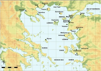
From the mid-eighth to the mid-seventh century bc, sites within the north-eastern Aegean region exhibited a high degree of similarity in ceramics, metal finds (fibulae), burial practices and architecture (Spencer Reference Spencer1995, 273, 288–96; Aslan Reference Aslan2009a, 39; Danile Reference Danile2012a, 20–3; Danile Reference Danile, Tiverios, Missailidou-Despotidou, Manakidou and Arvanitaki2012b, 84; Ilieva Reference Ilieva and Kotsonas2014). Archaeologists have used the term ‘koine’ to describe other cases in which inhabitants at settlements within a region employed a common vocabulary of material culture; here the term will be used to emphasise the close cultural ties seen during this period.Footnote 1 The koine encompassed the Troad, the Gallipoli peninsula, the north-eastern Aegean coast (Thrace) and the islands of Thasos, Lemnos, Lesbos, Samothrace and Tenedos (Fig. 1).Footnote 2 Although settlements within this region tended to form an interaction sphere during other periods as well (Aslan, Kealhofer and Grave Reference Aslan, Kealhofer and Grave2014, 283–4), during this phase, the similarities and interconnections are so striking that one suspects that regional centres (at Troy and on Lemnos and Lesbos) were creating and disseminating trends in material culture and probably were instrumental in establishing and maintaining the interactions between settlements.
Map showing the location of sites within the north-eastern Aegean region (prepared by G. Bieg).

Excavations at the site of Maydos-Kilisetepe (ancient Madytos) have uncovered three houses belonging to a settlement, which may have been established by people moving out from one of the larger regional centres. This article will first present the new evidence from Maydos and then compare Maydos with the site of Troy, which is located not far away on the other side of the Hellespont and further inland. Finally, both of these sites will be evaluated in relation to the larger region including the Troad, the Gallipoli peninsula and the north-eastern Aegean. The evidence from Maydos and Troy is indicative of wider changes, as one can see the spread of the north-eastern Aegean koine culture and its later replacement with Ionian material culture as colonies were founded in this region from the second half of the seventh to the early sixth century.
MAYDOS: EXCAVATIONS
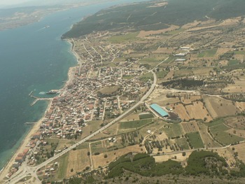
The mound of Maydos-Kilisetepe is situated within the modern town of Eceabat on the Gallipoli peninsula and faces the city of Çanakkale on the other side of the narrow water passage (Hellespont/Dardanelles) connecting the Aegean and Marmara seas. The site is a multiphased mound and measures 200 m × 180 m with a height of 33 m above sea level. It is located approximately 200 m inland from the modern coastline and has a commanding view of sea traffic through the straight (Fig. 2). Despite the geographically strategic importance of the Gallipoli peninsula, also known as the Thracian Chersonese, little archaeological research has been conducted there,Footnote 3 and therefore the excavations at Maydos fill a significant gap in our knowledge.
View of the mound of Maydos in relation to the Hellespont. The mound is visible in the centre of the town (courtesy of the Eceabat municipality).

The ancient name of the Greek polis was Madytos, and the area was still known as Maydos until the 1930s. The Turkish name Kilisetepe refers to a church to St Demetrios, which is no longer standing but could still be seen at the top of the mound in early twentieth-century photographs (Sazcı Reference Sazcı2012, 390; Sazcı Reference Sazcı2013a, 29). Only a few ancient sources mention the polis of Madytos, usually as part of descriptions of the geography of the region (Herodotus 7.33; Strabo 7, fragment 55: Jones Reference Jones1924; Xenophon, Hellenica, 1.1.3; Pseudo-Skymnos 698–710: Korenjak Reference Korenjak2003; see also Isaac Reference Isaac1986, 161; Loukopoulou Reference Loukopoulou, Hansen and Nielsen2004, 908–9). According to Pseudo-Skymnos (698–710: Korenjak Reference Korenjak2003) and Strabo (7, fragment 55: Jones Reference Jones1924), people from Lesbos founded a colony at Madytos; however, as will be shown in the following discussion, it is difficult to either support or refute this claim.
Excavations at Maydos began in 2010.Footnote 4 The earliest ceramics date to the Late Chalcolithic period, and there is evidence for Early, Middle and Late Bronze Age habitation along with some activity during the Early Iron Age. We have not yet found material that can be securely dated to the ninth or early eighth century bc. The buildings and finds from the second half of the eighth to the early sixth century will be discussed in detail later. Middle to Late Archaic and Hellenistic ceramics have been found in mixed contexts and not in clear association with architecture. Byzantine remains and burials have caused some disturbance to the earlier levels (Sazcı Reference Sazcı2012, 401–2; Sazcı Reference Sazcı2013a, 32–3).
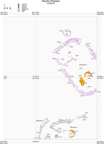
Two trenches, excavated from 2012 to 2014 (quadrants 4/2 and 4/4), uncovered parts of three oval or apsidal structures (Fig. 3). In the northern area, a complete oval structure with two floor phases was unearthed (Structure 2). In the southern area, parts of two curvilinear structures were found; one structure was built over the other, and neither has been excavated completely (Structures 1 and 3). A pit was also found, which was probably contemporary with Structure 1. The earliest phase (Structure 1 and the pit) can be dated to the mid-eighth to mid-seventh century bc. Structures 2 and 3 can be dated to the second half of the seventh century, possibly extending to the early sixth century bc.
Plan of Structures 1–3 and the pit (Maydos-Kilisetepe Project image).

Structure 1 (750–650 bc)
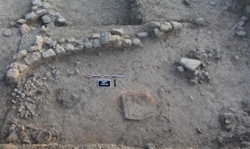
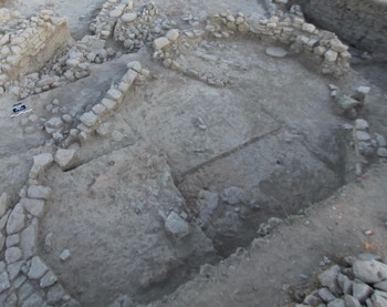
The earliest of the oval or apsidal structures is represented by wall 38 in the southern part of quadrant 4/4 (Fig. 4). Part of a long wall and a curving end are preserved; at least half the building is still within an unexcavated area. The preserved wall segment enclosed an interior space at least 5 m long and 2.5 m wide, but the building originally must have been longer as well as wider, possibly 4 to 5 m wide (based on comparisons with Structure 2). The wall socle (c.0.5 m wide) was formed of irregularly sized fieldstones, and only one course appears to have survived.
View of Structure 1 from the south. Hearth is visible in the centre, and the pot can be seen in the lower-left corner (Maydos-Kilisetepe Project image).

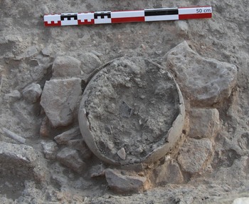
At the western end of the building, a simple hearth (hearth 1) was discovered. Not far from the hearth was a pot partly embedded in the ground and surrounded by small stones to keep it in place (Fig. 5). An ash pit was found to the west of the hearth at a similar elevation. Evidence for a hard-packed earth floor was found in the area near the hearth but was not identified throughout the interior. The hearth and the pot indicate that the western end of the building functioned for cooking, heating and some storage. The elevation of the hearth and floor is the same as the base of the stones of the wall (wall 38), indicating that there were no foundations to the walls.Footnote 5
View of pot surrounded by small stones in Structure 1 (Maydos-Kilisetepe Project image).

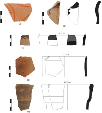
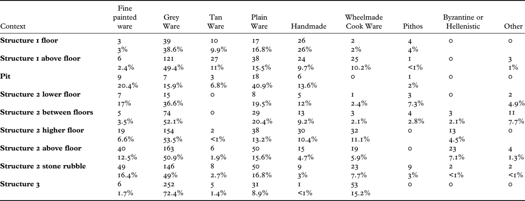
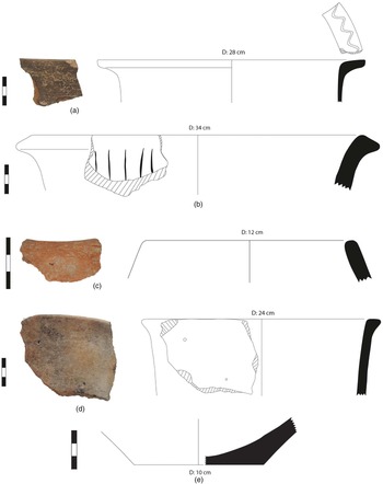
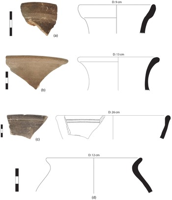
The material recovered from the floor of the building and from the use levels above the floor (Figs 6, 7)Footnote 6 includes ceramics such as Grey Ware (cat. nos 5, 6) and painted G2/3 Ware (cat. no. 3), which are typical of north-eastern Aegean assemblages and will be discussed in more detail later. Wheelmade cooking ware is present (cat. no. 10), although handmade jars or cooking pots also occur (cat. nos 8, 9). There is also a large storage jar (cat. no. 7). A banded kantharos (cat. no. 2) is probably related to G2/3 Ware and has parallels with finds from Troy from the eighth century. Painted ware also includes a jug fragment with concentric circles (cat. no. 1). A Tan Ware kantharos (cat. no. 4) is a common shape of the late eighth to mid-seventh century, although the shape was more frequently produced in Grey Ware or G2/3 Ware (Ilieva Reference Ilieva2011, 179). For quantification of the sherds according to ware types in all the contexts see Tables 1, 2, 3 and 4.
Ceramics from Structure 1: (a) cat. no. 1; (b) cat. no. 3; (c) cat. no. 2; (d) cat. no. 4; (e) cat. no. 5 (Maydos-Kilisetepe Project images).

Sherd counts according to context. The top number represents the total number of sherds of a particular ware type. The bottom number is the percentage of that ware type within the context. All types of sherds (rim, base, handle, body) are included.

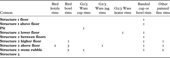
Fine painted ware vessel types represented by number of rim sherds in each context.
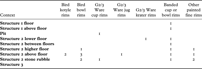
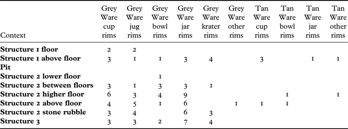
Grey and Tan ware vessel types represented by number of rim sherds in each context.

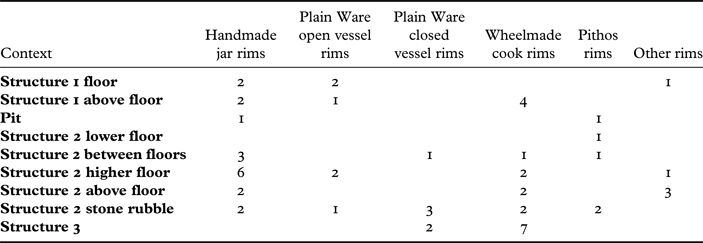
Handmade, plain ware, cooking ware, pithos and other vessels represented by number of rim sherds in each context.

The date of Structure 1 can be placed within the mid-eighth to mid-seventh century, based on G2/3 Ware and Grey and Tan Ware shapes. It should be noted that no bird kotylai were found in this structure. G2/3 Ware was also found in the levels directly underneath the structure, indicating that this was probably not the first structure built in this area.
Pit (750–650 bc)
A pit was found in the northern part of quadrant 4/2.Footnote 7 Many of the ceramic pieces have black discoloration. It is possible that it was either primarily or secondarily reused as a garbage/latrine pit. It is likely that other areas surrounding the oval/apsidal structures were used for various tasks or for garbage disposal. However, many of these exterior spaces were disturbed by later activity, and it was difficult to securely identify exterior surfaces or deposits that could be associated with a neighbouring structure.
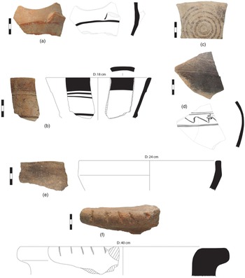
The pit can be dated to the mid-eighth to the first half of the seventh century on the basis of two G2/3 Ware fragments (cat. nos 11, 12) and Grey Ware (cat. no. 14) (Fig. 8). This means that it was roughly contemporary with Structure 1, although it is possible that originally there were other buildings closer to the pit that have not yet been excavated. The pit had been dug into levels dating to the eleventh or tenth century, and a few fragments may have been mixed in from the surrounding soil, including a Protogeometric amphora (cat. no. 13) and a handmade jar or deep bowl (cat. no. 15). One pithos rim was also discovered (cat. no. 16).
Ceramics from Structure 1: (a) cat. no. 6 (b) cat. no. 7; (c) cat. no. 8; (d) cat. no. 9; (e) cat. no. 10 (Maydos-Kilisetepe Project images).

Ceramics from the pit: (a) cat. no. 11; (b) cat. no. 12; (c) cat. no. 13; (d) cat. no. 14; (e) cat. no. 15; (f) cat. no. 16 (Maydos-Kilisetepe Project images).

Structure 2: Walls 28, 37 (650–575 bc)
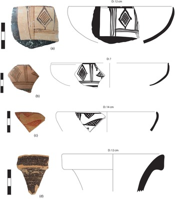
Structure 2 is roughly oval in shape, measuring 8 m × 4.5 m, with a fieldstone wall socle similar to Structure 1 (Fig. 9). Two phases can be identified. In the first phase, a thin dividing wall separated the northern third of the building. A hearth (hearth 2, 1.12 m in diameter) was located on the centre axis of the building, towards the southern end. A round, flat stone (0.58 m in diameter) set against the northern wall was found at a similar elevation to the hearth (Fig. 10). A similar round, flat stone (0.54 m in diameter) was also found in the second phase of the building, but not directly next to the wall; their exact function is unclear. From the first phase, a hard-packed earth floor could be identified in the northern area near the flat stone and the wall and in the southern area near the hearth. The floor and the interior features are at a lower elevation than the base stones of the socle. The most likely explanation is that the structure was originally dug into the ground and was semi-subterranean. Dugout or semi-dugout houses dating to the late seventh century were common at the earliest Greek colonies in the Black Sea area (Tsetskhladze Reference Tsetskhladze and Tsetskhladze1998, 20–1), and it is possible that the structure at Maydos is an earlier example of this practice. The contexts from the first phase did not contain much pottery; only 41 sherds were recovered (Figs 11, 12).Footnote 8 No G2/3 Ware was found. Some of the painted banded pieces could date to within the seventh century (cat. nos 17, 18, 19). The majority of the sherds are Grey Ware, including a kantharos (cat. no. 21), a jar or table amphora (cat. no. 22) and a simple bowl (cat. no. 20). One Grey Ware jug rim is in a similar shape to G2/3 Ware (cat. no. 23). There is one handmade cooking pot (cat. no. 24), which is unusual to find in this time period, when most cooking pots were wheelmade.
View of Structure 2 from the east (Maydos-Kilisetepe Project image).

View of the northern end of Structure 2 showing the flat stone and thin dividing wall (Maydos-Kilisetepe Project image).

Ceramics from Structure 2, phase 1: (a) cat. no. 17; (b) cat. no. 18; (c) cat. no. 19; (d) cat. no. 20 (Maydos-Kilisetepe Project images).

Ceramics from Structure 2, phase 1: (a) cat. no. 21; (b) cat. no. 22; (c) cat. no. 23; (d) cat. no. 24 (Maydos-Kilisetepe Project images).

The second phase in the building is marked with a new hearth (hearth 3, 0.70 m in diameter), located in the south-west quadrant of the building, in addition to a new flat stone at approximately the same elevation as the new hearth but at the opposite end of the building. It is possible that the dividing wall may have been out of use during this phase based on the surviving elevation of the socle, which is lower than the new floor level, although the exact relation of the floor to the socle could not be determined. Traces of a white lime plastered floor could be seen in the southern part of the structure. An abundance of ceramics was recovered from phase 2 contexts – 608 sherds were recovered from the second floor level and immediately above it (Figs 13, 14, 15, 16).Footnote 9 The amount seems too much for one building, and it is possible that the building was used as a trash disposal area after it went out of use for habitation. The ceramics include bird kotylai (cat. no. 26) and bird bowls (cat. nos 28–31) or closely related vessels (cat. no. 27). A Protocorinthian kotyle fragment was found in this level (cat. no. 25). Approximately half of the ceramics are Grey Ware, including kantharoi, table amphorae and jugs (cat. nos 34, 35). There are also fragments of various painted jars and table amphorae (cat. no. 32). Two spindle whorls were some of the few small finds (cat. nos 36, 37). The latest dating pieces are three fragments of cups that are probably a local emulation of Ionian cups dating to 625–575/550 bc (cat. no. 33), but the cups were found in a context that also held some Byzantine disturbance,Footnote 10 so it is difficult to be certain that these truly belong to the use of this building.
Ceramics from Structure 2, phase 2: (a) cat. no. 25; (b) cat. no. 26; (c) cat. no. 27; (d) cat. no. 28 (Maydos-Kilisetepe Project images).

Ceramics from Structure 2, phase 2: (a) cat. no. 29; (b) cat. no. 30; (c) cat. no. 31; (d) cat. no. 32 (Maydos-Kilisetepe Project images).

Ceramics from Structure 2, phase 2: (a) cat. no. 33; (b) cat. no. 34; (c) cat. no. 35 (Maydos-Kilisetepe Project images).

Spindle whorls from Structure 2, phase 2: (a) cat. no. 36; (b) cat. no. 37 (Maydos-Kilisetepe Project images).

At the southern end of the structure was a deposit with many stones above the floor level, either deliberate fill or perhaps collapsed stones from the walls.Footnote 11 The stone fill contained similar ceramics to the upper levels within the structure (Fig. 17), including Grey Ware (cat. nos 40, 41, 42) and a banded kotyle with a shape similar to bird kotylai (cat. no. 38).
Ceramics from Structure 2, stone rubble: (a) cat. no. 38; (b) cat. no. 39; (c) cat. no. 40; (d) cat. no. 41; (e) cat. no. 42 (Maydos-Kilisetepe Project images).

Although the elevation of Structure 2 is slightly lower than that of nearby Structure 1,Footnote 12 the ceramics suggest that Structure 2 is later. The use of this structure can be dated to within the period from 650 to 575 bc on the basis of some of the banded wares, the later types of bird bowls and the Ionian cup fragments (cat. nos 28, 29, 30, 31, 33, 39). Certain typical ceramics that are common in the mid-sixth century at Troy, especially Black-Figure and Black-Glazed ceramics, are not present in these contexts, indicating that Structure 2 probably ceased being used before the middle of the sixth century.
Structure 3 (650–575 bc)
Wall 32 is a curving wall that was probably part of a second apsidal or oval structure that was built over Structure 1. For this wall only one line of stones was unearthed, and we assume that the wall socle is very poorly preserved and originally would have been more substantial (Fig. 18). There are no clear floor levels or interior features such as hearths.
View of Structure 3 from the south (Maydos-Kilisetepe Project image).

There are two contexts that might be associated with Structure 3 (Figs 19, 20, 21).Footnote 13 The contexts contained a majority of Grey Ware (72.4% of the assemblage is Grey Ware, cat. nos 46–49) with only a few pieces of banded wares, mostly jugs or table amphorae with comparanda in the late seventh to early sixth century (cat. nos 43–45). Wheelmade cooking pots may also date to the seventh to sixth century (cat. nos 50–52). A spindle whorl was the only small find (cat. no. 53). Although it is likely that this structure dates to approximately the same time period as Structure 2, it is interesting that there are so few painted fineware vessels here. Notably, there are no bird kotylai or bird bowls.
Ceramics from Structure 3: (a) cat. no. 43; (b) cat. no. 44; (c) cat. no. 45; (d) cat. no. 46 (Maydos-Kilisetepe Project images).

Ceramics from Structure 3: (a) cat. no. 47; (b) cat. no. 48; (c) cat. no. 49; (d) cat. no. 50 (Maydos-Kilisetepe Project images).

Ceramics and a spindle whorl from Structure 3: (a) cat. no. 51; (b) cat. no. 52; (c) cat. no. 53 (Maydos-Kilisetepe Project images).

OVAL/APSIDAL BUILDINGS: COMPARANDA AND FUNCTIONS
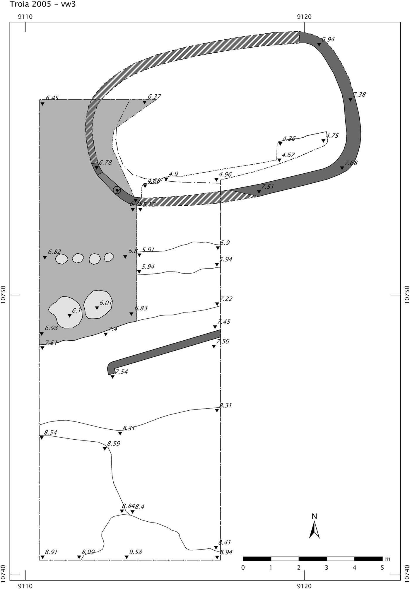
Both curvilinear and rectilinear structures can be found in the north-eastern Aegean from the eighth to the seventh century. Oval and apsidal buildings are often interpreted as having specialised community or religious functions. At Troy, an oval building dating to the first half of the seventh century was discovered outside of the usual areas of habitation in quadrant vw3 (Fig. 22). The building is similar in size to the structures at Maydos (9.71 m × 5.35 m) and has fairly narrow foundations of fieldstones (0.30–0.50 m wide). The large quantities of fineware drinking vessels, as well as its unusual location, suggest that communal drinking took place there, possibly with a ritual component (Aslan Reference Aslan2011, 381–409). Several oval or apsidal buildings were also discovered on Lesbos. An oval or apsidal building at Antissa is much larger (6.1 m × 14 m) than the ones at Maydos and has finely constructed polygonal masonry suggesting either an elite house or community building (Spencer Reference Spencer1995, 285; Mazarakis Ainian Reference Mazarakis Ainian1997, 91). Both Pyrrha and Mytilene on Lesbos have oval or apsidal structures, which have been interpreted as religious buildings dating to the eighth to seventh century (Schiering Reference Schiering1989; Spencer Reference Spencer1995, 283, 296–9; Mazarakis Ainian Reference Mazarakis Ainian1997, 89–90, 92). On Lemnos, excavations at Avlonas near Myrina have uncovered a large apsidal building (11 m × 17 m) dated to the end of the eighth century. It is suggested that the building may have had multiple functions as an elite house, ritual space and political centre for the community (Ficuciello Reference Ficuciello2010, 76–9).
Plan of oval structure at Troy, quadrant vw3 (Troia Project image, prepared by R. Becks).

Somewhat further away, buildings in the area of Ionia also bear comparison. At Smyrna, an oval house with a cross-wall with similar dimensions to those at Maydos was in use during the period 750–650 bc (Building C, c.9.00–9.20 m. in length, Fagerström Reference Fagerström1988, 95–6; Akurgal Reference Akurgal1983, 28–32, fig. 15; Mazarakis Ainian Reference Mazarakis Ainian1997, 108–9). An apsidal or oval structure was also found near the later temple of Artemis at Ephesus; it may have been an earlier cult building (Bammer Reference Bammer1982, 61; Fagerström Reference Fagerström1988, 97). Thin, curving walls dating to the Late Geometric period are also known from Miletus, with one building measuring 11.50 m × 6 m, larger than the ones from Maydos (Kleine Reference Kleine1979, figs 3, 4, 115; Mazarakis Ainian Reference Mazarakis Ainian1997, 109–10). Two seventh-century apsidal houses have also been uncovered at Klazomenai (Ersoy Reference Ersoy, Moustaka, Skarlatidou, Tzannes and Ersoy2004, 49–52).
There is little reason to suspect that the buildings at Maydos were anything other than houses, based on the hearths, pot set into the floor, ceramics that fit within a domestic assemblage, spindle whorls and lack of votives, figurines or possible ritual equipment. The finds and architectural construction at Maydos also do not indicate that these were houses of elite members of the community. No metal objects, such as fibulae, or any other items of jewellery or high-status small finds have yet been found. Ceramics, such as the bird bowls in Structure 2, show that the inhabitants were able to obtain imported pottery, but this is not unexpected considering the location of the site right near the Hellespont. As excavation at Maydos continues, we suspect that more of these houses may be found, which would confirm that they made up a small settlement there.
CERAMICS AND NORTH-EASTERN AEGEAN INTERCONNECTIONS
Grey Ware was the most common ceramic type at Maydos in the mid-eighth to seventh century and it comprises at least half of the ceramic assemblage in the majority of the contexts (Table 1). Grey Ware had a long tradition in north-western Anatolia and the north-eastern Aegean islands (Lamb Reference Lamb1932, 1–3; Bayne Reference Bayne2000; Polat Reference Polat2002, Reference Polat2008; Danile Reference Danile2011). It was the pre-eminent local ware at Troy from the Late Bronze Age to the Middle Archaic period until production decreased during the second half of the sixth century (Blegen et al. Reference Blegen, Boulter, Caskey and Rawson1958, 21, 155, 252–3; Pavúk Reference Pavúk2002; Aslan Reference Aslan2002, 91–2; Aslan Reference Aslan and Avram2009b). It was also common on Lesbos (Lamb Reference Lamb1932; Bayne Reference Bayne2000, 200–17) and Lemnos (Bayne Reference Bayne2000, 217–25; Danile Reference Danile and Greco2008a, Danile Reference Danile, Emanuele and Papi2008b, 39–44, Danile Reference Danile2011). Although one can see some differences in Grey Ware shapes when comparing Troy, Lemnos and Lesbos, there are enough similarities to see them as variations within one ceramic tradition. The Grey Ware at Maydos is very similar to that found at Troy, which is not unexpected considering their proximity. Tan Ware is closely related to Grey Ware, but it was relatively uncommon during the Geometric to Archaic phases in this region (Blegen et al. Reference Blegen, Boulter, Caskey and Rawson1958, 22–3, 253; Aslan Reference Aslan and Avram2009b, 268–9).
Grey Ware vessels usually have a burnished surface in a medium-grey colour, and the fabric is fairly fine, often containing small white quartz inclusions and silver mica. A range of shapes can occur including cups, bowls, table amphorae, jars and kraters. Although some shapes such as table amphorae show few changes over time, cup shapes in particular can be used as chronological markers. One shape that is characteristic of the mid-eighth to mid-seventh century is the deep kantharos, which occurs in Grey, Tan and painted Wares at Maydos (cat. nos 2, 4, 11, 21, 40). Maydos has a number of Grey Ware vessels that appear to be imitating painted ware shapes, including Grey Ware jugs that resemble painted G2/3 Ware jugs (cat. no. 5).
G2/3 Ware was the predominant painted fineware of the mid-eighth to mid-seventh century in this region and was named after quadrant G2/3 at Troy (Fisher Reference Fisher1996; Ilieva Reference Ilieva, Bonias and Perreault2009, Reference Ilieva, Adam-Veleni, Kefalidou and Tsiafaki2013a, Reference Ilieva and Kotsonas2014). The vessels are decorated with small Geometric motifs (especially zigzags, dots, X's, or step patterns) set within fields of empty space on upper sections of the vessels. Often the lower parts of the vessels have painted horizontal bands. Decoration is usually in brown or red/orange paint on a light tan slipped background. The ware was typically produced in the form of kantharoi, small cups, jugs, kraters and occasionally bowls; however, at Maydos only small cups, kantharoi and jugs have so far been found.
Results from different types of clay analysis (NAA, petrography, X-ray fluorescence and micro-XRF spectroscopy) indicate that there were several centres of manufacture of G2/3 Ware, although the two largest production centres were probably at Troy and on Lemnos (Mommsen, Hertel and Mountjoy Reference Mommsen, Hertel and Mountjoy2001, 196–8; Karadima et al. Reference Karadima, Matsas, Blondé, Picon, Kilikoglou, Hein and Maniatis2002, 159; Ilieva Reference Ilieva and Kotsonas2014, 90–1; Ilieva et al. Reference Ilieva, Tsiafaki, Tsirliganis, Sakalis and Kazakis2014, 574). G2/3 Ware has also been found at many other sites within the north-eastern Aegean, including Troy, Samothrace, Thasos, Tenedos, Lesbos, Antandros, Eion, Neapolis, Karabournaki, Argilos, Methone, Skyros and Asar Tepe.Footnote 14
Based on evidence from Troy and Lemnos, G2/3 Ware has been dated to the mid-eighth to mid-seventh century. On Lemnos, G2/3 Ware pottery was found with an Early Protocorinthian kotyle dating to 725–700 bc (Danile Reference Danile, Tiverios, Missailidou-Despotidou, Manakidou and Arvanitaki2012b, 84). It is likely that production had begun by at least the mid-eighth century. There are contexts at Troy that contain earlier versions or forerunners of G2/3 Ware dating to the eighth century, and it is possible that the ware started to develop at Troy even as early as the ninth century (Aslan Reference Aslan2002, 86). Production and use at Troy appears to have stopped following a destruction at the site during the middle of the seventh century (Aslan Reference Aslan2009a, 39).
Although there is G2/3 Ware at Maydos, the quantities are much smaller than at Troy, Lemnos, Thasos or Samothrace. For example, only four rim sherds of G2/3 Ware vessels were found in the contexts studied here (Table 2). Also, the range of shapes found at Maydos is limited to only cups, kantharoi and jugs, and so far no large mixing vessels such as kraters or dinoi have been found. We suspect that the smaller quantities and limited shape range at Maydos are attributable to differences in function and wealth, but it is also possible that preferences or trading patterns played a role.
In the upper level of Structure 2 at Maydos, bird bowls and bird kotylai were new additions to the assemblage. Bird kotylai and bird bowls are distinctive ceramics decorated with waterbirds, and stand out among the other ceramics at Maydos (Kerschner Reference Kerschner1995; Cook and Dupont Reference Cook and Dupont1998, 26–7; Coldstream Reference Coldstream2008, 277–9, 479). Bird kotylai are of the earlier type, dated to 720–650 bc; bird bowls are slightly later, dating to 675–550 bc (Kerschner Reference Kerschner1995, 1). Results from NAA show that Teos in Ionia was one of the manufacturing centres for these vessels (Kerschner et al. Reference Kerschner, Mommsen, Beier, Heimermann and Hein1993, 209; Kerschner Reference Kerschner, Kerschner and Lemos2014, 109, n. 7; Kadıoğlu et al. Reference Kadıoğlu, Özbil, Kerschner, Mommsen, Yalçin and Bienert2015, 349–53). At Maydos, more than 80 examples of these vessels have been found, with the majority of them being bird bowls.Footnote 15
Based on the date range (720–650 bc), one would expect that bird kotylai would frequently appear in the same contexts as G2/3 Ware (750/725–650 bc), but this is not the case. Bird kotylai were not found alongside G2/3 Ware in the contexts in or below Structure 1 or in the pit. At least 12 bird kotylai have been found at Troy,Footnote 16 but in many contexts with G2/3 Ware, no bird kotylai were found (Aslan Reference Aslan2002 [quadrant D9]; Aslan Reference Aslan2009a [quadrant K4/5], Aslan Reference Aslan2011 [quadrant vw3]). Carl Blegen documents four contexts at Troy where G2/3 Ware was found with bird kotylai, but in three cases the deposits were disturbed and later pottery was also present. In the apsidal building at Antissa on Lesbos, both bird kotylai and bowls were found alongside G2/3 Ware and Protocorinthian ceramics, although the stratigraphy there may not be entirely trustworthy (Lamb Reference Lamb1931/2, 56, 58, pl. 23, nos 8, 16, 21).
The fact that bird kotylai have not been found more frequently in contexts with G2/3 is related to other evidence that these vessels were not commonly exported to the north-eastern Aegean or Black Sea region. Only a few bird kotylai are reported from Lemnos (Rizzo Reference Rizzo and Messineo2001, 303, fig. 373 (4 examples), Danile Reference Danile, Tiverios, Missailidou-Despotidou, Manakidou and Arvanitaki2012b, 84), and Antandros (in the southern Troad, at least two examples: Polat and Polat Reference Polat and Polat2006, fig. 7), and so far none has been published from other sites such as Samothrace, Thasos, Tenedos, Abdera or Asar Tepe. Michael Kerschner's research (Kerschner Reference Kerschner2006a, 237–9) on bird kotylai in the Black Sea area records only two pieces. The 12 examples found at Troy seems like a large number in comparison with the rest of the north-eastern Aegean, and yet at the same time, it is a small number when considering the extent of excavations at Troy and the numerous contexts from the eighth to mid-seventh century that contain none of these vessels.
The rarity of bird kotylai is symptomatic of a wider pattern. In general, although sites within the north-eastern Aegean show strong similarities and interactions with one another, there is little evidence for trade or interactions beyond this region. There is only a very small amount of Protocorinthian pottery at Troy, Lemnos or Lesbos (Lamb Reference Lamb1931/2, 58; Blegen et al. Reference Blegen, Boulter, Caskey and Rawson1958, 257; Danile Reference Danile2011, 96, 108). A few pieces that may be from Chian jars have been found at Troy (Aslan Reference Aslan2009a, 36), but there is little other imported pottery from mainland Greece, Ionia or Lydia. Danile (Reference Danile, Tiverios, Missailidou-Despotidou, Manakidou and Arvanitaki2012b, 84) has made a similar observation for Lemnos. Likewise, G2/3 Ware is rarely found outside of the north-eastern Aegean.Footnote 17
At Maydos, bird kotylai occur alongside bird bowls in the upper phase of Structure 2. A bird bowl was found in the phase 2 floor level and can be dated to 640–610 bc based on comparanda (cat. no. 28). In the layers above this floor, both bird kotylai and bird bowl fragments were found. In other words, it appears that bird kotylai and bird bowls arrived at the site around the same time (during the second half of the seventh century). This picture does not fit the usual understanding of the chronology of these wares. Either the production of certain types of bird kotylai overlapped with bird bowls more than previously thought, or people brought heirloom vessels with them to Maydos. It is also possible that further excavations at Maydos will produce stratigraphic sequences that can allow us to see finer chronological developments in material culture. The bird bowls and kotylai at Maydos are just one signal of the establishment of Ionian colonies in the area of the Troad, the Hellespont and the Sea of Marmara in the mid-seventh to sixth century, which is discussed in more detail in the final section. The changes in ceramics at Maydos may be evidence of new settlers, or they may simply indicate that the inhabitants of Maydos were participating in increased trade and travel through the Hellespont.
It is odd that there are not many ceramics from Maydos from the second part of the sixth century, when population was rising in the north-eastern Aegean (see below). Structures 2 and 3 do not seem to have been used later than the early sixth century. There are a few mid- to late sixth-century ceramics (Black-Figure, Black-Glazed) from mixed contexts above the houses, but the numbers are very small. It is possible that habitation shifted to another part of the mound or that the remains were removed in later periods during Byzantine construction.
MAYDOS AND TROY: A COMPARISON
Maydos is located close to Troy, although one would have had to cross the Hellespont to travel from one site to the other. Although we initially expected the two sites to be very similar, there are differences that are instructive about the relative developments and regional roles of the two sites.
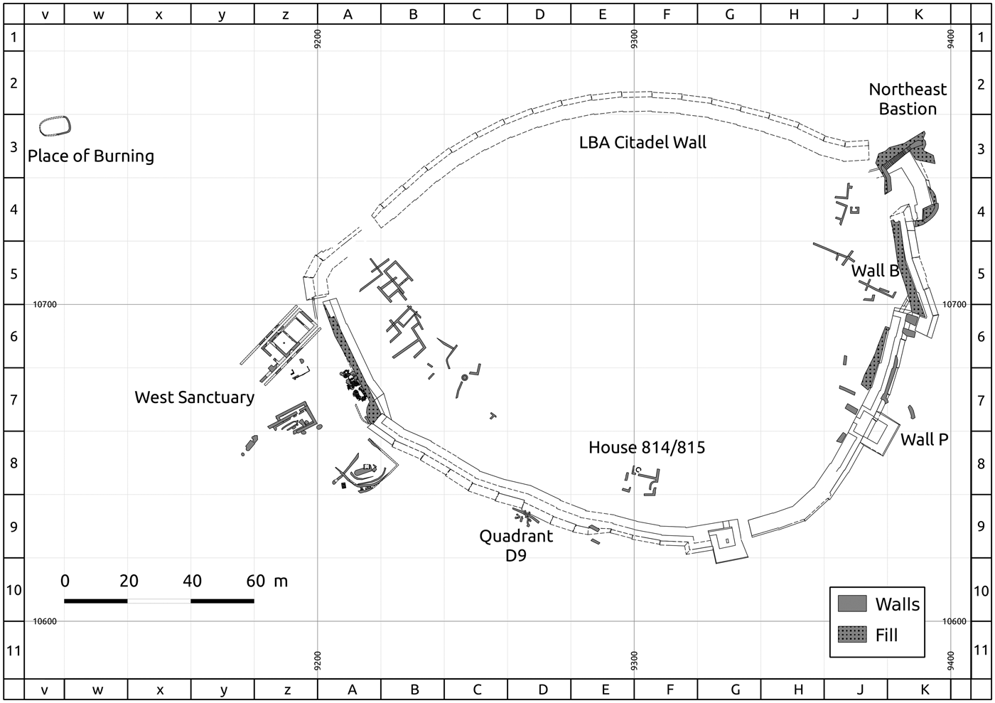
Several strands of evidence suggest that Troy experienced a fairly prosperous time from the mid-eighth to the mid-seventh century and that it was one of the larger centres of population in the region. First of all, it should be noted that Troy is currently the only site in the north-eastern Aegean region where archaeologists have documented continuous habitation or at least activity extending from the Late Bronze Age to the mid-seventh century (Aslan Reference Aslan2002, 82–3).Footnote 18 Settlement continued to be focused in and around the Late Bronze Age citadel and its impressive fortification wall (Fig. 23). It is possible that the fortification walls would have been heavily damaged by this time and not especially effective for defence, but Wilhelm Dörpfeld's excavation results (Dörpfeld Reference Dörpfeld1902, 202–5) show that the citadel wall was reinforced with additional walls or rubble packing sometime within the Troy VIII phase (Geometric to Archaic). Later investigations showed that at least two of these walls can be dated to the Late Geometric to Early Archaic period (wall 793 in A7 and a curving wall in K4/5; see Hnila Reference Hnila2012, 201; Aslan Reference Aslan2009a, 34–5). Therefore, it is possible, although not certain, that the other areas of rubble packing and reinforcement walls can also be dated to this phase. In terms of other architecture, it is likely that some of the rectangular Troy VIII structures excavated by Carl Blegen at Troy belong to this phase, including House 814 in quadrants E–F8/9, wall P (quadrant K7) and wall B (quadrant J5). Dörpfeld (Reference Dörpfeld1902, 198, fig. 77, 206–7, pl. VI) excavated walls in quadrants H/J 4–7 and A/B/C 5–7, and our best guess, based on the published ceramics, is that these buildings can also be assigned to the eighth to mid-seventh century bc.
Plan of Troy from the Protogeometric to Archaic phases (Troia Project image, prepared by P. Hnila).

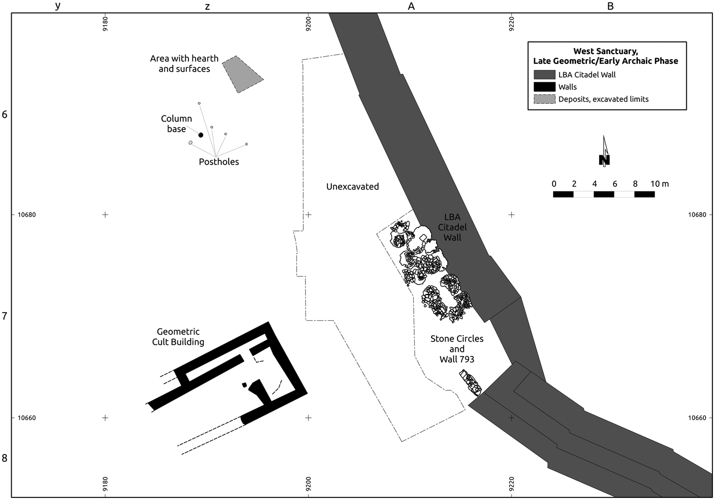
Another sign that Troy had a significant role in this region is that a religious sanctuary with multiple ritual activity areas was in use at this time. A rectangular building in an area known as the West Sanctuary can be interpreted as a temple (Fig. 24). It was the third temple at the same location. The first version dated to the Late Bronze Age (Becks, Rigter and Hnila Reference Becks, Rigter and Hnila2006; Rose Reference Rose2014, 24), the second was probably built in the late ninth or eighth century and the building was remodelled a third time in the late eighth to early seventh century (Basedow Reference Basedow, Morris and Laffineur2007, 52; Basedow Reference Basedow, Bachhuber and Roberts2009, 131, 139; Aslan Reference Aslan2011, 412). This is strong evidence that some community knowledge of this area as a sacred space was passed down from the Late Bronze Age to the Early Archaic period (Aslan Reference Aslan2011, 412–20; Aslan and Rose Reference Aslan, Rose, Redford and Ergin2013, 14–15; Aslan and Hnila Reference Aslan, Hnila, Stampolidis, Maner and Kopanias2015, 202–5). Not far from this temple was an installation of low stone circles where it is likely that feasting rituals occurred, based on the drinking cups and large mixing vessels found there (kraters and dinoi) (Blegen et al. Reference Blegen, Boulter, Caskey and Rawson1958, 274–5; Basedow Reference Basedow, Morris and Laffineur2007, 52; Basedow Reference Basedow, Bachhuber and Roberts2009, 135, 139; Aslan Reference Aslan2011, 412–16; Aslan and Rose Reference Aslan, Rose, Redford and Ergin2013, 11–13; Rose Reference Rose2014, 50–1). Also, in the southern area of the West Sanctuary, the bones of carnivores (lion, leopard and bear) as well as deer antlers have been found. The bones are from teeth, skulls or feet, and it is likely that animal skins were brought to this area either as part of costumes or as votives (Blegen et al. Reference Blegen, Boulter, Caskey and Rawson1958, 263; Rose Reference Rose2014, 56). Taking the evidence together, it is apparent that the West Sanctuary had multiple rituals areas in use during the mid-eighth to mid-seventh century. Not far from the West Sanctuary (the Place of Burning in quadrant vw3), was the oval structure that was described earlier in the architectural comparanda section. The fact that it is the only oval structure so far found at Troy also suggests a distinct role or function, or perhaps it was associated with a particular segment of the society.
Plan of the West Sanctuary at Troy in the Late Geometric to Early Archaic phases (Troia Project image, prepared by P. Hnila).

In addition to the architecture, Troy has many deposits of ceramics from the mid-eighth to the mid-seventh century, and the quantity as well as quality is high. Deposits of pottery were found within the citadel and directly outside it, again indicating that the area within the citadel walls was still the centre of settlement (Blegen et al. Reference Blegen, Boulter, Caskey and Rawson1958, 280–3; Aslan Reference Aslan2002, 85–7; Aslan Reference Aslan2009a, 34–7; Hertel Reference Hertel2008a, 60–5, 68–71). As previously mentioned, clay analysis has shown that Troy was one of the manufacturing centres for G2/3 Ware. It is also possible that Troy was one location where G2/3 Ware was first developed, based on the finds of early forerunners to G2/3 Ware (Aslan Reference Aslan2002, 92–3). Troy helped maintain the long tradition of Grey Ware in this region and also manufactured this ware (Mommsen, Hertel and Mountjoy Reference Mommsen, Hertel and Mountjoy2001, 199–200).
On the basis of architecture, one could argue that Maydos and Troy were not very similar, except possibly for the one oval structure found at Troy, which seems to have been exceptional. Troy had a religious sanctuary outside the citadel wall, structures within the central citadel area and possibly a reinforced citadel wall. With the continuing presence of the Late Bronze Age walls of the central citadel, it still must have been an impressive site. The quantity of ceramics found at Troy also suggests that it was a large and prosperous settlement. Although future excavations may alter this picture, it does not seem that Maydos was as large or as wealthy as Troy during this period.
Unlike Maydos, Troy has evidence for a destruction in the middle of the seventh century. The evidence consists of layers of rubble in several different parts of the site, which cover layers containing G2/3 Ware (Aslan Reference Aslan2009a, 36–8). G2/3 Ware is rarely found in the layers above the rubble, and it is likely that G2/3 Ware production was halted. The cause of the destruction is unknown. An earthquake is a possibility, but one does not see the effects of the same event at Maydos. The destruction appears to have caused much disruption at Troy and possibly a period of hiatus or very low population. In contrast to Maydos, Troy has very small numbers of bird bowls; only five certain examples are known (Blegen et al. Reference Blegen, Boulter, Caskey and Rawson1958, no. 18, fig. 310; Fisher Reference Fisher2000, 168, no. 62; Hertel Reference Hertel, Wemhoff, Hertel and Hansel2008b, 159, 160, nos 101, 102).Footnote 19 This could be explained if there was a hiatus at Troy following the destruction, during the time when bird bowls were most common. The temple in the West Sanctuary and the oval building in quadrant vw3 were destroyed and not rebuilt. Troy eventually recovered in the late seventh century, and once again a religious centre was re-established in the West Sanctuary, but rebuilding did not take place on the exact site of the earlier temple. New ritual practices were also introduced at this time, specifically votive dedications of small cups and bowls decorated with swans (Aslan Reference Aslan and Aygün2009c, 54–5). These changes can be better understood by examining evidence from the wider region.
MAYDOS AND TROY WITHIN THE NORTH-EASTERN AEGEAN
Troy and Maydos were just two sites that participated in a cultural koine within the north-eastern Aegean. Why and how this koine emerged and when it started to change or break apart are important questions. To start with the question of the beginnings of this koine, in the mid-eighth to mid-seventh century, there was a proliferation of new settlements in this region. Settlements or cemeteries are known from the Troad (Troy, Antandros), Lemnos (Hephaisteia, Chloi and Myrina), Lesbos (Antissa, Pyrrha, Methymna, Agios Phokas and Klopedi), Thasos, Tenedos, Samothrace, Skyros and the north-eastern Aegean coast (Asar Tepe, Neapolis, Eion, Argilos and Karabournaki/Therma).Footnote 20 In contrast, the ninth century is poorly known or understood in this region, and it is likely that it was a time of very few settlements and general depopulation. Troy is one of the few sites with possible ninth-century material (Aslan Reference Aslan2002, 84–5). At Maydos, no clear ninth-century remains have been found, although there are some fragments of Protogeometric amphorae that may date to the tenth century. Occupation started again at Maydos during the mid-eighth to early seventh century, and the site can be added to the picture of population growth and an increase in settlements in the north-eastern Aegean.
One important question is whether these new settlements represent a migration to this region or were the result of an increase in local populations following difficulties during the ninth century. Ceramics support an argument for these changes being a regional development rather than stimulated by migration. Around half of the ceramics are Grey Ware, which has a long tradition in north-western Anatolia starting in the Late Bronze Age. A new ceramic type is G2/3 Ware, but one can see antecedents of G2/3 Ware at Troy (Aslan Reference Aslan2002, 92–3), and it is likely that it developed in this region. G2/3 Ware is also not similar to Late Geometric ceramics from other regions, and so it is unlikely that it was introduced from another area. As mentioned earlier, there is little evidence for imports or contacts from other areas of the Aegean (Ionia or mainland Greece), which is further evidence against migration or external influences on these developments.
Certain sites, especially Troy and Hephaisteia on Lemnos, were probably regional centres in this koine. Hephaisteia also developed a religious centre in the seventh century, and an extensive cemetery dates to this phase (Ficuciello Reference Ficuciello2010, 43–9, 51–68; Danile Reference Danile2011, 108–16). Lemnos has some distinct shapes and variations of Grey Ware and G2/3 Ware, and clay analysis suggests that it was another manufacturing centre of G2/3 Ware (Ilieva Reference Ilieva and Kotsonas2014, 90–1; Ilieva et al. Reference Ilieva, Tsiafaki, Tsirliganis, Sakalis and Kazakis2014, 574). It is likely that Troy and sites on Lemnos and perhaps Lesbos had an important role in the formation of this cultural koine and in setting certain trends in ceramics, metal or architectural forms. Some of the smaller sites that were newly founded during this phase (such as Antandros, Maydos and on Samothrace and Tenedos) may have been the result of people moving out from these larger centres.
The second half of the seventh century brought changes to the region. Ancient sources document that the area of the Troad and both shores of the Hellespont became of great interest to colonists from Ionia, Lesbos, Athens and Paros (Isaac Reference Isaac1986, 160–6, 198–201; Ehrhardt Reference Ehrhardt1988, 32–7; Tenger Reference Tenger and Schwertheim1999, 121–6; Loukopoulou Reference Loukopoulou, Hansen and Nielsen2004, 900–2; Rose Reference Rose2008, 415–19; Aslan and Pernicka Reference Aslan and Pernicka2013, 38–40; Rose Reference Rose2014, 58–9). For the Gallipoli peninsula, ancient traditions record the founding of Madytos/Maydos and Sestos by people from Lesbos, and Alopekonnesos by colonists from Lesbos and Kyme. Miletus is said to have founded Limnai and Kardia (along with Klazomenai), and Athens is associated with the foundation of Elaious (Pseudo-Skymnos, 707: Korenjak Reference Korenjak2003; Isaac Reference Isaac1986, 163). The evidence from sites such as Assos (Utili Reference Utili1999, 142–4), Sigeion (Cook Reference Cook1973, 178–80; Bieg and Aslan Reference Bieg and Aslan2006, 133–4; Schäfer Reference Schäfer2009; Körpe and Yavuz Reference Körpe, Yavuz and Aygün2009b, 230; Schäfer Reference Schäfer2011, 410), Elaious (Waiblinger Reference Waiblinger, Puig, Lissarrague, Rouillard and Rouveret1999, 97–9; Chamonard, Dhorme and Courby Reference Chamonard, Dhorme and Courby1915, 180–4), Aigospotamoi (Körpe and Yavuz Reference Körpe, Yavuz and Aygün2009a, 226–7) and Parion (Tavukçu Reference Tavukçu2006, 212–13, 358–9, pl. 33, 34; Başaran et al. Reference Başaran, Keleş, Kasapoğlu and Ergürer2012, 21–2; Aytaçlar and Kozanlı Reference Aytaçlar and Kozanlı2012, 81–7) indicates that the late seventh to mid-sixth century saw a rise in population and new settlements in both the Troad and the Gallipoli peninsula. Bird bowls and bird kotylai at Maydos are probably just one indication of increasing contacts with Ionia. In addition to bird bowls, other ceramics such as Ionian cups and Wild Goat Style and banded bowls also signal the increasing influence of Ionian cultural products. It has been documented through clay analysis that the colonists established local production of Wild Goat Style vessels and probably Ionian cups somewhere within the Troad (Mommsen, Kerschner and Posamentir Reference Mommsen, Kerschner and Posamentir2006, 165–7; Mommsen et al. Reference Mommsen, Cowell, Fletcher, Hook, Schlotzhauer, Villing, Weber, Williams, Villing and Schlotzhauer2006, 70; Posamentir and Solovyov Reference Posamentir and Solovyov2006, 114–17; Posamentir and Solovyov Reference Posamentir and Solovyov2007, 196–201; Posamentir et al. Reference Posamentir, Arslan, Bîrzescu, Karagöz and Mommsen2009; Kerschner Reference Kerschner2006b, 148–51; Dupont Reference Dupont2008, 1–6, 11–14; Aytaçlar and Kozanlı Reference Aytaçlar and Kozanlı2012, 79–80; Aslan and Pernicka Reference Aslan and Pernicka2013, 45–8). It is notable that only a few pieces of Wild Goat Style have been found at Maydos, and not within cleanly stratified contexts. There are a few, probably local versions of Ionian cups found within Structure 2, but the numbers are small.
As previously mentioned, one ancient source preserves a tradition of the polis of Madytos being founded by Aiolians from Lesbos (Pseudo-Skymnos, 698–710: Korenjak Reference Korenjak2003). It is not possible based on the current evidence to indicate who might have moved to Madytos during the mid-eighth century. Lesbos is one possible point of origin because it does have oval and apsidal architecture, G2/3 and Grey Ware, but so do many other sites within this region. On the other hand, this ancient tradition may refer to a slightly later period in the late seventh to sixth century, and Madytos may have been grouped together with other colonies established by Lesbos located on the Gallipoli peninsula.
Therefore, the mid-seventh century marks the transformation of the cultural koine. With the establishment of the new colonies and trade into the Black Sea, the predominant cultural forms in the areas bordering the Hellespont became highly influenced by Ionia and Athens. The destruction of Troy during the mid-seventh century must have been intertwined with this cultural and political shift. If Troy was an important regional centre of the koine, as been argued, its destruction may have made it easier for newcomers to enter the region and for new forms of material culture to become established. As mentioned, the cause of the destruction of Troy is yet unknown. The only conflict recorded around this time is the battle between Athens and Mytilene for control of Sigeion, located on the coast near Troy (Herodotus 5.94.1; Strabo, Geography, 13.1.38–9; Leaf Reference Leaf1923, 187–8; Page Reference Page1955, 152–8; Isaac Reference Isaac1986, 162). Isaac dates this to the last quarter of the seventh century. It is certainly likely that there was conflict in the region as the colonies were established, but it is also possible that the destruction of Troy was the result of a natural event that gave the colonists an opportunity to move into the region and shift the power dynamics.
CONCLUSIONS
Although Troy has long been a focus of archaeological research, the excavations at Maydos present an opportunity for comparison and new understanding of this region. Both Troy and Maydos were part of a cultural koine in the Late Geometric to Early Archaic periods, but although they share a closely similar ceramic culture, there are also evident differences between the sites. The architecture at Maydos is curvilinear, whereas most architecture at Troy is rectilinear, with only one exception. Troy was probably a much larger population centre with a complex religious sanctuary and a level of prestige enhanced by its long history and its still-standing Late Bronze Age citadel wall. Maydos also had a smaller shape range in G2/3 Ware ceramics. Developments at the two sites also diverge in the middle of the seventh century. While Troy was destroyed, habitation at Maydos continued, and we see the introduction of one new form of ceramics – bird kotylai and bird bowls. The Grey Ware tradition continued, and there is a sense of continuity with only the addition of some new fineware vessels. These new vessels from Ionia are just one signal of the upsurge in colonisation of the area bordering the Hellespont, especially by colonists from Ionia, but also from Athens and Lesbos, who brought profound changes to the settlement patterns, cultural interactions and material culture of the region.
CATALOGUE
Abbreviations
- Max. P. Dim:
-
maximum preserved dimension
- Est. D. Rim:
-
estimated diameter of rim
- Est. D. Base:
-
estimated diameter of base
- Th:
-
thickness
- D:
-
diameter
- H:
-
height
Munsell colours designations are taken from the 2000 edition of the Munsell colour chart.
Structure 1
-
1. Painted jug or closed vessel (Fig. 6a )
4/4.239.1.4
Body fragment. Max. P. Dim. 6.7 cm. Wall Th. 0.9 cm.
Fabric: pink/orange (2.5YR 6/6), grey inclusions, brown grit, silver mica.
Description: Parts of three sets of concentric circles in orange paint (5YR 5/8) on tan/pink ground (5YR 7/6). Interior is untreated.
-
2. Painted kantharos related to G2/3 Ware (Fig. 6c )
4/4.119.1.8
Less than 1/16 of rim preserved. Est. D. Rim 12 cm. Max. P. Dim. 2.6 cm.
Fabric: brown/grey (7.5YR 5/2), no visible inclusions.
Description: Brown band (5YR 4/3) along the top of the rim and interior. Light-grey ground (2.5YR 7/1). Streaky brown paint on interior. Handle was attached at the rim; its root is preserved.
Comparanda: Troy (Aslan Reference Aslan2002, no. 40, Geometric phase, 800–700 bc)
-
3. G2/3 Ware jug (Fig. 6b )
4/4.239:7
Body fragment. Max. P. Dim. 5.8 cm. Th. 0.5 cm.
Fabric: layers of pink/orange (2.5YR 6/6) and tan/pink (5YR 7/4), fine, silver mica.
Description: Exterior has a band above a ridge and possibly part of a vertical squiggle. Dark-brown paint (2.5YR 3/2) on tan/cream ground. Interior is untreated, tan/pink colour (2.5YR 7/4).
-
4. Tan Ware kantharos (Fig. 6d )
4/4.59.1.6
1/16 of rim preserved. Est. D. Rim 12 cm.
Fabric: brown (10YR 5/4), white and grey quartz inclusions, brown grit, silver mica.
Description: Interior and exterior are burnished, light-brown colour (10YR 6/4). Faint incised line on exterior.
Comparanda: Shape resembles Grey Ware kantharoi of the Geometric–Early Archaic period. See Troy (Aslan Reference Aslan2002, nos 100, 101, pls 12–13, date: 700–650 bc; Aslan Reference Aslan2011, 394–5, no. 31, date: 700–650 bc); Smyrna (Bayne Reference Bayne2000, 163, no 2, fig. 39).
-
5. Grey Ware jug (Fig. 6e )
4/4.59.1.3
1/8 of rim preserved. Est. D. Rim 13 cm.
Fabric: grey (5YR 5/1), a few white quartz inclusions, a lot of silver mica.
Description: Exterior is burnished, grey (5YR 5/1). Interior is unburnished.
Comparanda: shape resembles G2/3 Ware jugs, see Troy (Aslan Reference Aslan2011, 390–1, no. 11, date: 700–650 bc).
-
6. Grey Ware krater or jar (Fig. 7a )
4/4.118.1.1
1/16 of rim preserved. Est. D. Rim 28 cm.
Fabric: uneven grey/brown, white and grey quartz inclusions, a lot of silver mica.
Description: Burnished on interior and exterior, grey colour (Gley 2 4/5PB). Incised wavy line on top of the rim.
-
7. Plain Ware large storage jar (Fig. 7b )
4/4.239.1.1
Less than 1/16 of rim preserved. Est. D. Rim 34 cm. Wall Th. 1.8 cm.
Fabric: orange (2.5YR 5/8) with a lighter orange core, white sand, silver mica.
Description: Exterior has vertical lines in brown paint. Ground has a light-brown slip (2.5YR 6/4). Interior is burnished, uneven grey/brown colour.
-
8. Handmade Coarse Ware jar (Fig. 7c )
4/4.124.1.1
1/8 of rim preserved. Est. D. Rim 12 cm.
Fabric: brown/orange (5YR 4/6), coarse sand, silver mica.
Description: Interior and exterior are brown/orange (5YR 5/6). Some slight burnishing marks are visible.
-
9. Handmade jar or cooking pot (Fig. 7d )
4/4.123.1.1
1/8 of rim preserved. Est. D. Rim 24 cm.
Fabric: dark grey/brown (2.5YR 3/1), a lot of sand and a lot of silver mica.
Description: Two small pierced holes. Rim is flat on top. Exterior is slightly burnished, mottled grey/brown colour.
-
10. Wheelmade cooking pot (Fig. 7e )
4/4.120.1.4
1/18 of base preserved. Est. D. Base 10 cm.
Fabric: dark brown (7.5YR 3/2), sand, brown grit, silver mica.
Description: Flat base. Exterior is grey (7.5YR 4/1). Interior is dark grey (7.5YR 3/1).
Comparanda: Troy (Aslan Reference Aslan2009a, 47, nos 88, 89, date: 750–700 bc).
Pit
-
11. G2/3 Ware kantharos (Fig. 8a )
4/2.158.1.3
Body fragment and handle stub. Max. P. Dim. 9 cm. W. of handle 2.8 cm.
Fabric: orange/brown (5YR 6/8), no visible inclusions.
Description: Red band (5YR 6/6) marking a slight ridge. Light-brown ground (7.5YR 6/4). Interior has streaky red paint.
Comparanda: Troy (Hertel Reference Hertel, Wemhoff, Hertel and Hansel2008b, no. 62, 148–9).
-
12. G2/3 Ware jug or large kantharos (Fig. 8b )
4/2.161.1.3
1/6 of rim preserved. Est. D. Rim 18 cm. Wall Th. 0.5 cm.
Fabric: tan (5YR 6/4), no visible inclusions.
Description: Wide band along the rim with a ridge marking the lip. Two thin bands below the wide one. Another thin band lower on the body marks a second ridge. Brown paint (5YR 3/2) on uneven tan/cream ground.
Comparanda: Samothrace (Moore Reference Moore, Lehmann and Spittle1982, no. 52, 366–7, has a smaller diameter); Troy (Blegen et al. Reference Blegen, Boulter, Caskey and Rawson1958, no. 13, fig. 304; no. 3, fig. 312; no. 11, fig. 318; Hertel Reference Hertel, Wemhoff, Hertel and Hansel2008b, no. 31, 136, 138); Lemnos – Hephaestia (Messineo Reference Messineo2001, 149, no. 113, fig. 144).
-
13. Protogeometric painted amphora (Fig. 8c )
4/2.158.1.2
Body fragment. Max. P. Dim. 10.8 cm.
Fabric: light brown (10R 6/4), white and grey inclusions, gold and silver mica.
Description: Dark-brown paint (7.5YR 3/2) on tan/grey ground (7.5YR 7/2). Interior is light brown (10YR 6/4).
Comparanda: Troy PG Group III (Lenz et al. Reference Lenz, Ruppenstein, Baumann and Catling1998, 206–8).
-
14. Grey Ware jar or krater (Fig. 8d )
4/2.158.1.4
Body fragment. 2 joining. Max. P. Dim. 11 cm.
Fabric: brown (7.5YR 4/2), small white quartz inclusions.
Description: Incised wavy line motif between bands of incised horizontal lines. Exterior is burnished. Colour varies from dark grey (7.5YR 3/1) to medium grey.
Comparanda: Troy (Blegen et al. Reference Blegen, Boulter, Caskey and Rawson1958, nos 9, 11, fig. 313).
-
15. Handmade Coarse Ware bowl or jar (Fig. 8e )
4/2.162.1.1
1/8 of rim preserved. Est. D. Rim 24 cm.
Fabric: brown (7.5YR 4/6), mica and small stones.
Description: Interior and exterior are brown/grey (2.5YR 5/2).
-
16. Pithos or large storage vessel (Fig. 8f )
4/2.161.1.1
Less than 1/16 of rim preserved. Est. D. Rim 40 cm. Max. P. Dim. 13.3 cm. Wall Th. 3.9 cm.
Fabric: brown/grey (10YR 5/3), white quartz and lime inclusions, mica.
Description: Interior and exterior are unburnished, brown/grey colour (10YR 5/3). Diagonal slashes along the outside of the rim.
Comparanda: Troy (Aslan Reference Aslan2009a, 47, no. 97, date: 750–700 bc).
Structure 2: Phase 1
-
17. Banded bowl (Fig. 11a )
4/2.228.1.16
1/16 of rim preserved. Est. D. Rim 22 cm.
Fabric: tan (7.5YR 7/4), white inclusions, silver mica.
Description: Red bands (2.5YR 5/8) on tan/pink ground (7.5YR 8/4).
Comparanda: Didyma (Schattner Reference Schattner2007, Bowl type B1, 382–91, especially no. 17 fig. 107, date: 650–550 bc).
-
18. Banded table amphora (Fig. 11b )
4/2.228.1.17
1/16 of rim preserved. Est. D. Rim 14 cm.
Fabric: light brown (5YR 6/4), white and grey inclusions, silver mica.
Description: Triangular-shaped rim. Dark-brown paint (7.5YR 3/2) on exterior and as a band on the upper part of the interior. Interior is light-grey/cream slipped (10YR 7/1).
-
19. Banded jar (Fig. 11c )
4/2.235.1.3
1/16 of rim preserved. Est. D. Rim 14 cm.
Fabric: tan (7.5YR 6/4), small white inclusions, silver mica.
Description: Orange/brown (2.5YR 5/6) band along the rim on interior and exterior. No paint on top of rim. Tan ground (7.5YR 7/4).
-
20. Grey Ware bowl (Fig. 11d )
4/2.237.1.1
1/6 of rim preserved. Est. D. Rim 28 cm.
Fabric: grey (7.5YR 5/1), a few white quartz inclusions, silver mica.
Description: Well burnished on interior and exterior. Grey colour (7.5YR 5/1).
Comparanda: Smyrna (Bayne Reference Bayne2000, 167, no. 2, fig. 43).
-
21. Grey Ware kantharos (Fig. 12a )
4/2.231.1.3
Less than 1/16 of rim preserved. Max. P. Dim. 6.6 cm. Cannot determine diameter.
Fabric: grey/brown (2.5YR 5/1), white lime inclusions, silver mica.
Description: Exterior is grey burnished (Gley 1 6/N) with an incised wavy line and incised horizontal lines. Interior is unburnished.
-
22. Grey Ware jar (Fig. 12b )
4/2.228.1.2
1/8 of rim preserved. Est. D. Rim 14 cm.
Fabric: grey (5YR 5/1), white quartz inclusions, silver mica.
Description: Exterior is burnished, grey (Gley 1 5/N). Interior is untreated.
Comparanda: Troy (Aslan Reference Aslan2009a, 44, no. 48, date: 700–650 bc).
-
23. Grey Ware jug (Fig. 12c )
4/2.228.1.13
1/8 of rim preserved. Est. D. Rim 11 cm.
Fabric: grey (5Y 5/1), white quartz inclusions, silver mica.
Description: Exterior is burnished, dark grey (Gley 1 4/N). Interior is untreated.
Comparanda: similar to G2/3 Ware jugs, Troy (Aslan Reference Aslan2011, 390–1, no. 11, date: 700–650 bc).
-
24. Handmade cooking pot (Fig. 12d )
4/2.237.1.4
1/4 of base preserved. Est. D. Base 8 cm.
Fabric: uneven brown/grey, sand inclusions, silver mica.
Description: Interior is grey (7.5YR 7/1), exterior is an uneven grey/brown colour. Smoothed but not burnished.
Comparanda: similar to Protogeometric cooking pots, Troy (Aslan, Kealhofer and Grave Reference Aslan, Kealhofer and Grave2014, 298, nos 21, 22).
Structure 2: Phase 2
-
25. Protocorinthian kotyle (Fig. 13a )
4/2.46.1.5
Body fragment. Max. P. Dim. 2.9 cm. Wall Th. 0.03 cm.
Fabric: cream (10YR 8/3), no visible inclusions.
Description: Interior has brown/black paint (10YR 3/1). Exterior has orange bands (2.5YR 5/8) on tan/yellow ground (10YR 8/4).
Comparanda: Coldstream Reference Coldstream2008, pl. 21e, 21f, date: 720–670 bc.
-
26. Bird kotyle (Fig. 13b )
4/2.61.1.49
1/16 of rim preserved. Est. D. Rim 20 cm.
Fabric: dark grey/brown (5YR 4/2), no visible inclusions.
Description: May be burnt or misfired, resulting in a darkened band along the top. Part of a tree of life motif next to a metope and possibly a lotus flower on the right. Brown/black paint (5YR 3/1) on tan/grey ground (7.5YR 6/2). Interior has brown/black paint.
Comparanda: Bird kotyle type V or VI (Kerschner Reference Kerschner1995, 14–15, figs 26, 27, date: 750–670 bc).
-
27. Painted kotyle, similar shape to bird kotylai (Fig. 13c )
4/2.61.1.46
1/16 of rim preserved. Est. D. Rim 16 cm.
Fabric: pink/orange (2.5YR 6/6), a few white inclusions, a little silver mica.
Description: Shape resembles a bird kotyle. Interior and exterior are burnished. Interior has a wide band, exterior has a thin band near the rim. Uneven red/brown paint (2.5YR 5/6) on tan ground (7.5YR 6/4).
-
28. Bird bowl (Fig. 13d )
4/2.73.1.17
1/6 of rim preserved. Est. D. Rim 14 cm.
Fabric: tan/grey (5YR 6/2), no visible inclusions.
Description: Waterbird with cross-hatched body standing on a set of three horizontal lines. Triangular filling motif above bird. Dotted circle in front of bird. Quarter circle in corner next to two lines of a metope. Dark-brown paint (10YR 3/2) on light-brown/grey ground (10YR 6/2).
Comparanda: Ephesus (Kerschner Reference Kerschner1997, 146–8, nos 75, 76, pl. 10, date: 640–620 bc); Caere (Kerschner Reference Kerschner1995, 18–19, fig. 47, bird bowl type III, date: 640–610 bc).
-
29. Bird bowl (Fig. 14a )
4/2.61.1.43
1/6 of rim preserved. Est. D. Rim 12 cm.
Fabric: grey/brown (2.5Y 5/1), no visible inclusions.
Description: Dark-brown paint (7.5YR 3/3) on tan ground (7.5YR 6/6). Cross-hatched diamond between metopes.
Comparanda: Ephesus (Kerschner Reference Kerschner1997, 146, 148, no. 76, pl. 10, date: 640–620 bc type IIIb); Miletus (Kerschner Reference Kerschner1995, 17–18, no. 43, bird bowl type II, date: 675–610 bc).
-
30. Bird bowl (Fig. 14b )
4/2.61.1.44
1/4 of rim preserved. Cannot determine diameter.
Fabric: light brown (7.5YR 6/4), no visible inclusions.
Description: Cross-hatched diamond next to a metope. Part of a pendent triangle and the back of a waterbird. Brown/grey paint (10YR 4/3) on light-brown ground (7.5YR 6/4).
Comparanda: bird bowl type II or III (Kerschner Reference Kerschner1995, 17–19, date: 675–610 bc).
-
31. Bird bowl (Fig. 14c )
4/2.61.1.51
1/16 of rim preserved. Est. D. Rim 14 cm.
Fabric: tan/pink (2.5YR 7/4), no visible inclusions.
Description: Part of a cross-hatched bird. Red/orange paint (10R 5/8) on tan/pink ground (5YR 7/4). Interior is painted, red/orange.
Comparanda: bird bowl type II (Kerschner Reference Kerschner1995, 17–18, fig. 40, date: 675–610 bc).
-
32. Black-painted table amphora (Fig. 14d )
4/2.61.1.48
1/16 of rim preserved. Est. D. Rim 12 cm.
Fabric: tan (7.5YR 7/3), no visible inclusions.
Description: Triangular-shaped rim. Exterior is completely black painted (10YR 2/1). Black band along the top of the rim on the interior.
-
33. Banded cup, related to Ionian cups (Fig. 15a )
4/2.73.1.18
Less than 1/16 of rim preserved. Est. D. Rim 16 cm.
Fabric: brown/orange (5YR 5/6).
Description: Dark-brown band along the lip (10YR 3/2), tan ground (7.5YR 7/4).
Comparanda: Parion (Aytaçlar and Kozanlı, Reference Aytaçlar and Kozanlı2012, 111, figs 106, 107).
-
34. Grey Ware trefoil jug (Fig. 15b )
4/2.61.1.1
1/8 of rim preserved. Max. P. Dim. 9.7 cm.
Fabric: grey (Gley 1 5/N), a few white quartz inclusions, silver mica.
Description: Exterior is burnished, grey colour (Gley 1 5/N). Interior is unburnished except for near the top of the rim.
-
35. Grey Ware table amphora (Fig. 15c )
4/4.205.1.4
1/16 of rim preserved. Est. D. Rim 14 cm.
Fabric: grey brown (2.5YR 5/1), white quartz inclusions, silver mica.
Description: Burnished on exterior, grey colour (10YR 5/1). Interior is untreated, grey/brown colour (2.5Y 5/1).
-
36. Spindle whorl (Fig. 16a )
4/2.71.4
H. 2.9 cm. D. 3.3 cm. D. hole 0.6 cm. Weight 32.0 g.
Fabric: grey/brown (5YR 5/2) white and grey inclusions, silver mica.
Description: Biconical. Uneven grey/brown coloured surface.
-
37. Spindle whorl (Fig. 16b )
4/2.74.4
H. 2.0 cm. D. base 3.6 cm. D. hole 0.7 cm. Weight 29.5 g.
Fabric: grey/brown (5YR 5/2), white inclusions, silver mica.
Description: Slipped, uneven grey/brown colour.
Structure 2: Stone rubble
-
38. Banded kotyle (Fig. 17a )
4/4.152.1.22
1/8 of rim preserved. Est. D. Rim 20 cm.
Fabric: pink/orange (2.5YR 6/8), white quartz inclusions.
Description: Exterior has brown/orange bands (5YR 4/6) on tan ground (7.5YR 7/6). Interior is tan.
Comparanda: resembles bird kotylai in shape.
-
39. Banded bowl (Fig. 17b )
4/4.198.1.4
1/16 of rim preserved. Est. D. Rim 20 cm.
Fabric: pink/orange (2.5YR 6/6), no visible inclusions.
Description: Interior and exterior are covered with brown paint (5YR 5/4) with the exception of a reserved band at the top of the rim.
-
40. Grey Ware kantharos (Fig. 17c )
4/4.191.1.14
Rim. 1/6 of rim preserved. Est. D. Rim 12 cm.
Fabric: dark grey/brown (2.5Y 4/2), white inclusions, silver mica.
Description: Interior is grey (5Y 6/1). Exterior is also grey (5Y 5/1) and has two sets of incised horizontal lines. Exterior is burnished, interior is unburnished.
Comparanda: Smyrna (Bayne Reference Bayne2000, 162, nos 1–3, fig. 38).
-
41. Grey Ware jar or table amphora (Fig. 17d )
4/4.152.1.4
1/8 of rim preserved. Est. D. Rim 18 cm.
Fabric: uneven grey and brown areas, a lot of fine white sand, a lot of silver mica.
Description: Visible vertical burnishing marks. Exterior and interior are mottled grey/brown.
-
42. Grey Ware jug or table amphora (Fig. 17e )
4/4.152.1.3
Rim, neck and handle stub. 1/8 of rim preserved. Est. D. Rim 12 cm.
Fabric: grey (Gley 1 5/N), white quartz and brown grit inclusions, silver mica.
Description: Exterior is grey (Gley 1 5/N).
Comparanda: Lesbos (Bayne Reference Bayne2000, 207, no. 1, fig. 61).
Structure 3
-
43. Banded bowl (Fig. 19a )
4/4.47.1.43
1/4 of base preserved. Est. D. Base 6 cm.
Fabric: pink/yellow (7.5YR 8/1), a few grey inclusions.
Description: Exterior and interior are banded with dark-brown bands (10YR 3/2) on cream-coloured ground (10YR 8/2).
Comparanda: Troy (Aslan Reference Aslan2002, 114, no. 141, pl. 17, date: 600/575–550 bc).
-
44. Banded table amphora or jar (Fig. 19b )
4/4.47.1.42
1/8 of rim preserved. Est. D. Rim 16 cm.
Fabric: pink/orange (2.5YR 6/6), a few white quartz inclusions, brown grit, silver mica.
Description: Brown paint (5YR 4/3) on tan/pink ground (5YR 7/4).
-
45. Painted table amphora or jar (Fig. 19c )
4/4.34.1.76
1/16 of rim preserved. Est. D. Rim 12 cm.
Fabric: tan (7.5YR 7/6), a few white quartz inclusions, silver mica.
Description: Exterior is completely painted with brown paint (7.5YR 4/2). Interior is tan (7.5YR 7/3).
-
46. Grey Ware jar (Fig. 19d )
4/4.34.1.7
1/16 of rim preserved. Est. D. Rim 20 cm.
Fabric: brown (5YR 5/4), white quartz inclusions, a lot of silver mica.
Description: Interior and exterior are burnished, grey colour (Gley 1 4/N).
-
47. Grey Ware jug (Fig. 20a )
4/4.34.1.14
1/8 of rim preserved. Est. D. Rim 9 cm.
Fabric: brown (5YR 5/4), white quartz, brown grit inclusions, silver mica.
Description: Exterior is burnished, grey. Interior is unburnished.
Comparanda: Lesbos (Bayne Reference Bayne2000, 206, no. 6, fig. 60).
-
48. Grey Ware jar/jug (Fig. 20b )
4/4.34.1.13
1/4 of rim preserved. Est. D. Rim 13 cm.
Fabric: grey/brown (10R 5/1), a few white quartz inclusions, brown grit, silver mica.
Description: Exterior is grey (5YR 5/1). Interior is unburnished.
-
49. Grey Ware large bowl (Fig. 20c )
4/4.47.1.2
1/8 of rim preserved. Est. D. Rim 26 cm.
Fabric: grey (10R 5/1), a few white inclusions, silver mica.
Description: Interior and exterior are burnished, grey colour (Gley 1 4/N). Incised lines on exterior.
Comparanda: Lemnos (Danile Reference Danile2011, no. 87, pl. 19).
-
50. Wheelmade cooking pot (Fig. 20d )
4/4.34.1.6
1/16 of rim preserved. Est. D. Rim 12 cm.
Fabric: brown (5YR 5/4), sand inclusions, brown grit, silver mica.
Description: Exterior is somewhat burnished. Colour is uneven grey and brown.
-
51. Wheelmade cooking pot (Fig. 21a )
4/4.34.1.61
1/4 of base preserved. Est. D. Base 9 cm.
Fabric: brown (5YR 5/4), white quartz inclusions, brown grit, silver mica.
Description: Uneven grey colour.
-
52. Wheelmade cooking pot (Fig. 21b )
4/4.47.1.4
1/2 of base preserved. D. Base 8 cm.
Fabric: brown (5YR 5/4), sand, brown grit inclusions, silver mica.
Description: Cushion-type base. Smoothed on interior and exterior. Grey/brown colour (2.5YR 4/1).
Comparanda: Troy (Aslan Reference Aslan2002, 112, no. 125, pl. 16, date: 625–600/575 bc).
-
53. Spindle whorl (Fig. 21c )
4/4.47.4
H. 2.8 cm. D. 3.7 cm. D. hole 0.6 cm. Weight 33.4 g.
Fabric: grey/brown (2.5YR 4/1), white sand, silver mica.
Complete, biconical whole. Incised wavy line and small dots.
ACKNOWLEDGEMENTS
We would like to express our appreciation for the support of the Turkish Ministry of Culture and Çanakkale Onsekiz Mart University for the excavations at Maydos. We could not have completed this article without help from many members of the excavation team including: Ayşe Özge Akbaş, Gözde Özge Şengüler, İnci Özen, Serap Yıldız (drawings), Devrim Çalış Sazcı and Selçuk Kalfa (photography), and Canan Özbaş (ceramic studies). We would like to sincerely thank Gülşah Günata for her work in preparing the final illustrations and also Pavol Hnila, Gebhard Bieg and Ralf Becks for their help with maps and plans. C. Aslan is grateful to Brian Rose and Ernst Pernicka for permission to study the Early Archaic material at Troy. C. Aslan would also like to thank Koç University for research and travel support.