Introduction
The New Caledonian Crow Honeyeater Eugymnomyza aubryana (Andersen et al. Reference Andersen, Gregory, Dickinson, Watling and Scofield2022) is endemic to mainland Grande Terre and is classified by the International Union for Conservation of Nature (IUCN) as “Critically Endangered” (BirdLife International 2018). Its habitat is rainforest, which was continuous over most of the island c.3,100 years ago at the time of human colonisation (Sand et al. Reference Sand, Bolé, Ouetcho, Bonvallot, Gay and Ch. and Habert2012a). The rainforest has been significantly reduced by deforestation and recurrent bush fires (Birnbaum et al Reference Birnbaum, Ibanez, Vandrot, Blanchard, Hequet and Chambrey2015; Sarasin Reference Sarasin1917). Today, rainforest occupies c.21% (3,400 km2) of Grande Terre (Bavard Reference Bavard1989; Jaffré et al. Reference Jaffré, Bouchet and Veillon1998) and is highly fragmented with only four large (>300 km2) patches remaining (Baudat-Franceschi Reference Baudat-Franceschi2013).
The Crow Honeyeater currently has a highly restricted distribution with most observations reported in and around the Blue River Provincial Park in the Southern Province of Grande Terre (Okahisa et al. Reference Okahisa, Legault, Angin, Chartendrault, Barré and de Franceschi2016). The Blue River Provincial Park, located 30 km in a straight line north-east of the capital Nouméa, is a provincial reserve of 220.7 km2, including 116 km2 of rainforest.
The Crow Honeyeater has had a much larger historical distribution. For example, on the north-east coast, in a 368 km2 patch of rainforest on the Panié Massif, birds have been recorded from the early 1900s until very recently. In an attempt to quantify the temporal change in distribution Crow Honeyeater’s records from museum skins, non-systematic sightings or vocal records, and sightings or vocal evidence from systematic bird surveys were compared.
Methods
To obtain early historical data on the distribution of the Crow Honeyeater, reports and scientific publications were searched together with online databases of museum collections on the VertNet site, major museums around the world and, where possible, institutions in the south-west Pacific region. The collection sites for most skins were obtained, but the Academy of Natural Sciences in Philadelphia and the Natural History Museum in Oslo did not provide the collection site for two skins collected in 1907 and 1927, respectively.
Although it was not certain that all early Crow Honeyeater records were obtained, it is likely that most were found. More recent distribution data were taken from published material, certified observations (defined here as either a sighting or vocal identification) by people familiar with the species, and the results of systematic surveys where bird species were recorded at locations along transects. Thus, comprehensive distribution data from skins, non-systematic sightings or vocal records outside of bird surveys, and sightings or vocal evidence from systematic bird surveys were obtained (Cassan et al. Reference J.-J, Duval and Villard2017; Okahisa et al. Reference Okahisa, Legault, Angin, Chartendrault, Barré and de Franceschi2016 and references therein; Villard and Bonenfant Reference Villard and Bonenfant2017). The distribution data are presented here separated into the Southern and Northern Provinces of Grande Terre.
Results
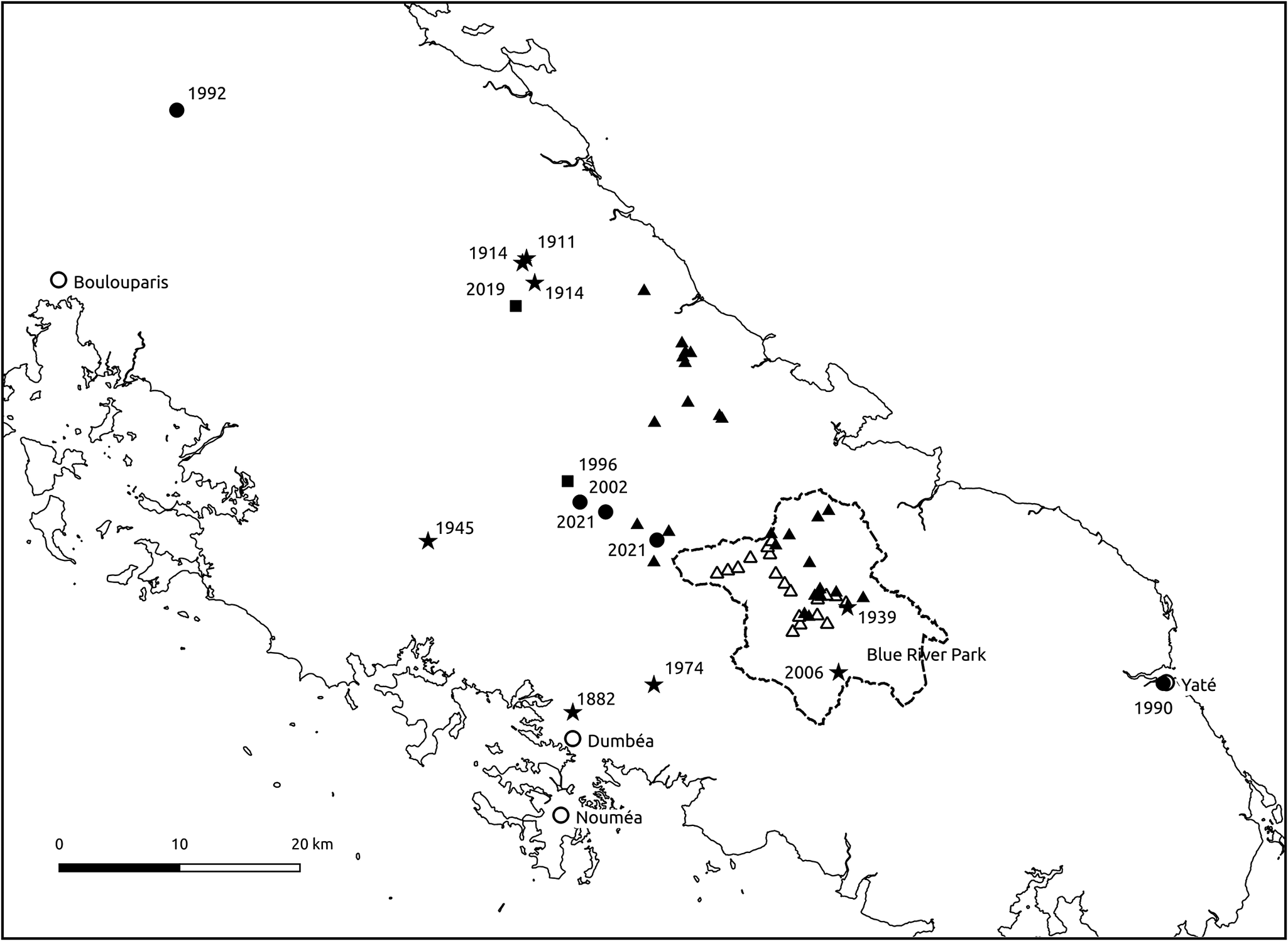
All the distribution data before 1950 were obtained from skins (Supplementary Table 1). The earliest data were two records from 1882, one at Dumbéa 8 km from Nouméa and one near Canala in the south of the Northern Province. In 1914, Montague spent a year in New Caledonia exploring much of Grande Terre, including several months in the Houaïlou valley (Adams Reference Adams2016). He collected four Crow Honeyeater skins, two in the north and two in the south, with 200 km between the northern and southern collections (Figures 1 and 2). Montague did not describe seeing any Crow Honeyeaters in the Houaïlou region, which is roughly in the middle of the island on the east coast. Sarasin (Reference Sarasin1913) also did not mention seeing Crow Honeyeaters in the Houaïlou valley when he was there in 1911. Macmillan (Reference Macmillan1939) mentioned two uncertain reports of the birds in the valley when he visited the region, but these were not confirmed. These reports appear to be the last possible evidence of Crow Honeyeaters in the Houaïlou area. On Mt Panié in the north-east of Grande Terre, 10 specimens were collected in 1939 (Macmillan Reference Macmillan1939). The last record before 1950 was on Mt Mou in 1945, which today is a reserve with a patchwork of rainforest, 20 km west of the Blue River Provincial Park.
The distribution of the Crow Honeyeater in the North Province. The line between Bourail (west coast) and Canala (east coast) indicates the north–south provincial boundary. The distribution of the Crow Honeyeater (data from Supplementary Table 1) is shown with three different icons based on the type of data: black-filled circle (a GPS location); black-filled square (place name and altitude); black-filled star (place name). Open circles indicate towns and villages, and open squares rainforest locations mentioned in the text (Kwaba and Kabéije). Insert: enlargement of Mt Panié.

Detailed map of the distribution of the Crow Honeyeater in the South Province from the first record in 1882 (data in Supplementary Table 1). Bird contacts on transects in the Blue River Provincial Park (1982 and 1999) are not shown. Only the GPS location of point counts with contacts during the 2010 (black-filled triangle) and 2017 (open triangle) surveys are shown. Description of the other icons is in the legend to Figure 1. The dotted line shows the boundary of the Blue River Provincial Park.

From 1950 to 2000, there were only two records (4 km apart) of the Crow Honeyeater in the Northern Province, a skin from Mt Panié collected in 1976 (Stokes Reference Stokes1980) and an observation in 1998 (Ekstrom et al. Reference Ekstrom, Jones, Willis and Isherwood2000) (Supplementary Table 1 and Figure 1). However, in the Southern Province there were five separate observations of individual birds from 1974 to 2002; the greatest distance between any two of the five observations was c.95 km. Censuses for Crow Honeyeaters were also carried out in the Blue River Provincial Park in 1982 and 1999 using four (4 km long) and six (22.5 km long) transects, respectively. Six Crow Honeyeaters were recorded in the 1982 transects and 25 in the 1999 transects (Supplementary Table 1; Létocart Reference Létocart2000).
Between 2003 and 2012, the rainforest on Grande Terre has been surveyed with around 3,000 point counts (Okahisa et al. Reference Okahisa, Legault, Angin, Chartendrault, Barré and de Franceschi2016). For example, on the Panié Massif 147 point counts were carried out from October 2003 to March 2004 (Chartendrault Reference Chartendrault2004), and 105 in 2009 (Franquet and Tron Reference Franquet and Tron2010). Although no Crow Honeyeaters were found in these two expeditions, their calls were heard on the east side of Mt Panié in 2005 (Blaffart in Baudat-Franceschi Reference Baudat-Franceschi2013) and 2010 (Duval Reference Duval, Tron, Franquet, Larsen and Cassan2013) (Supplementary Table 1 and Figure 1). An individual was also seen over eight days from October to December 2011 (de Franceschi Reference de Franceschi2011), about 2 km from where the bird was heard in 2010. The location of the sighting and the surrounding area on the slopes of Mt Panié were intensively searched for 27 days in 2015 from 7 September to 12 November using nightly point counts, playback of Crow Honeyeater calls, and an automatic noise recorder (Cassan et al. Reference J.-J, Duval and Villard2017). After this search our team (the author and a local guide) spent five days further north on neighbouring Mt Colnett unsuccessfully looking for the species.
In December 2015, our team also surveyed two locations in the central part of Grande Terre (Figure 1), spending four days in forest at Kabéije (near Houaïlou) and Kwaba (near Touho) without finding evidence of Crow Honeyeater presence. Therefore, the last confirmed presence of the Crow Honeyeater in the Northern Province is currently the sighting by de Franceschi (Reference de Franceschi2011). In the south of Grande Terre, the Crow Honeyeater is still present in six locations connected by continuous forest: Mt Humboldt, Mt Kouakoué, Ouinné, Mt Ouin, Mt Dzumac, and the Blue River Provincial Park (Supplementary Table 1). This was shown by a systematic survey consisting of 495 point counts in 2010 when 26 Crow Honeyeaters were recorded (Figure 2; Angin Reference Angin2011). In 2017, an intensive survey in the Blue River Provincial Park confirmed that the park contains the core of the remaining Crow Honeyeater population: 46 Crow Honeyeaters were recorded at 19 point-count locations over roughly a two-month period (Figure 2; Villard and Bonenfant Reference Villard and Bonenfant2017). Two records were collected outside the Blue River Provincial Park after 2017, which were chance sightings at Mt Humbolt and Ouinné (Supplementary Table 1).
Discussion
There is no doubt that the Crow Honeyeater has suffered a severe population decline since human arrival. For example, the species was known on and around the Panié Massif for 100 years from 1911 to 2011 (Supplementary Table 1), but has not been reported there, or indeed in the Northern Province, since 2011. Although there are few records on bird distribution on Grande Terre before 1950, it is possible that the Crow Honeyeater was already absent from much of the forest on the island when Europeans arrived. In 1914 Montague did not collect any Crow Honeyeater skins during his stay in the Houaïlou valley and the central part of Grande Terre. In 1939, Macmillan only reported two uncertain records when he visited these areas. Interestingly, in the same region three Kanak languages have a local name for the Crow Honeyeater – Douari, Djeke, and Chawayou (Baudat-Franceschi Reference Baudat-Franceschi2013; Chartendrault et al Reference Chartendrault, Desmoulins and Barré2007), which suggests an historical presence of the species. Thus, the species may have been rare outside the Panié Massif and the southern part of the island well over 100 years ago.
Two non-exclusive factors that might be associated with the above hypothesis are deforestation and hunting. First, it is known that Crow Honeyeaters are able to live in montane rainforest because they did so on the Panié Massif (e.g. one bird collected was at 1,500 m in 1939). They are also able to live in lowland rainforest because they still do so in the Blue River Provincial Park. There must have been a large amount of primary forest at a wide range of altitudes on Grande Terre when human colonisation began. The Kanak indigenous people first practised slash-and-burn itinerant cultivation, then around the year 1000, they established sedentary villages with intensive cultivation (Sand et al. Reference Sand, Bolé, Ouetcho, Bonvallot, Gay and Ch. and Habert2012b). Therefore, habitat destruction may have played an important role in Crow Honeyeater decline prior to the arrival of Europeans.
Lastly, the Crow Honeyeater was hunted by Kanak people in the past. They used slingshots (design and method of use Montague 1914 in Adams Reference Adams2021; Lambert Reference Lambert1901) as well as throwing sticks and stones (Macmillan Reference Macmillan1939; Sarasin Reference Sarasin1917). Firearms may also have been used to hunt the birds soon after the European arrivals. The Crow Honeyeater was once noted for sale in the Nouméa market as a game bird (Layard and Layard Reference Layard and Layard1882), but it is unknown if this was the result of Kanak or European hunting. Although the impact of hunting on the species is unknown, there is an association between the degree of isolation from humans and the presence of the two known sizeable populations on the Panié Massif and in the Blue River Provincial Park. The Panié Massif is extensive and rugged and contains New Caledonia’s higher peak at 1,628 m a.s.l. In the Blue River Provincial Park, it appears that the local Kanak slash-and-burn method to grow crops (yam Dioscorea sp. and taro Colocasia sp.) was never practised (Sand et al. Reference Sand, Bolé, Ouetcho, Bonvallot, Gay and Ch. and Habert2012b).
European arrival was associated with forest exploitation and the introduction of mammalian predators. Logging of forests by Europeans may have had a limited impact on Crow Honeyeaters in certain areas. For example, logging of primary forest only began around 1870 in the south of Grande Terre (Bavard Reference Bavard1989) and ended in 1978 on the site of the Blue River Provincial Park before its creation in 1980. The extensive damage to the rainforest was from selective logging not clear-felling (Bavard Reference Bavard1989). If Crow Honeyeaters in the Blue River Provincial Park initially moved out of selectively logged areas, they were able to re-colonise them as large regions of continuous unlogged forest still existed next to logged areas (e.g. at higher altitudes).
The main threat to rainforest habitat where Crow Honeyeaters currently live is from fire to clear land for agriculture and grazing, hunting, and mining exploration (Jaffré et al. Reference Jaffré, Bouchet, Veillon, Rigault and Dagostini1997). These fires, mainly of human origin, are generally limited to forest margins. Although very destructive, they do not cause irreversible long-term damage if they are not repeated. However, on the ultramafic substratum at low and medium altitudes, the high frequency of fire has reduced forest to remnant patches (Jaffré et al. Reference Jaffré, Bouchet, Veillon, Rigault and Dagostini1997). Fires on Grande Terre occur mostly in the dry season when the forest edge is vulnerable (Ibanez Reference Ibanez2012). During this season in the Blue River Provincial Park staff implement fire detection and control measures. There is no close monitoring for fire outside the park in areas where Crow Honeyeaters still occur, which means a continual reduction of their habitat over time. Prescribed burning around the forest edges when safe to do so could reduce the risk of forest damage (Ibanez et al. Reference Ibanez2012).
The main direct threat to Crow Honeyeater nests is likely from black rats Rattus rattus, introduced to Grande Terre around 1850 (Gargominy et al. Reference Gargominy, Bouchet, Pascal, Jaffré and Tourneur1996). Three Crow Honeyeater nests were monitored in 2019 during a study of breeding behaviour (Villard et al. Reference Villard, Mériot and Fuchs2023). Two of these nests were destroyed, one by an unknown predator and the other by a black rat (Villard et al Reference Villard, Mériot and Boudinot2022). In the following year only one nest was found. To prevent its predation by rodents, eight bait stations were installed on three 50 × 50 m grid near the nest tree, one at each corner (unpublished data), and the nest was successful. Black rats have been documented preying on the nests of endemic island birds. For example, in Hawaii they predated 24% of 191 nests of the Hawaii Elepaio Chasiempis sandwichensis and a rat control study was subsequently carried out comparing poisoned and non-poisoned plots (Banko et al. Reference Banko, Jaenecke, Peck and Brinck2019). Rat abundance was reduced and nesting success improved in the treated plots, suggesting that long-term rat removal should lead to increased reproductive success (Banko et al Reference Banko, Jaenecke, Peck and Brinck2019). Also in Hawaii, rat control with snap traps and poison was used for 16 years to protect the endangered Oahu Elepaio Chasiempis ibidis followed by the use of self-setting pneumatic traps (Vanderwerf et al. Reference VanderWerf, Taylor, Rohrer, Dittmar and Burt2023; use of the automatic traps is described in Shiels et al. Reference Shiels, Bogardus, Crampton, Gronwald, Kreuser, Baldwin and Lepczyk2022). This work increased breeding success and emphasised the value of long-term management techniques to control rat numbers.
Locating the nest of a Crow Honeyeater is often difficult. Therefore, to try and protect all the nests of a small population of Crow Honeyeaters from rats (e.g. the nine Crow Honeyeater territories monitored in Villard et al. Reference Villard, Mériot and Fuchs2023), bait stations could be installed throughout the population’s nesting range. This would require a large number of bait stations (around 600 stations over the nine territories if installed in a 50 m grid set up). The number could be reduced by targeting potentially suitable nesting trees. For example, in tall rainforest, four nests were built in a micro-habitat within young trees that had a high density of trunks (91% of trunks had a diameter less than 10 cm within a radius of 10 m from each nest) and a relatively open canopy (Villard et al. Reference Villard, Mériot and Fuchs2023). Self-setting traps would also reduce trap-monitoring effort.
Therefore, it is possible that black rats have had a significant impact on Crow Honeyeater populations since their introduction. For example, they are plentiful (sub-species R. r. frugivorus), large (up to 290 g), and particularly aggressive in the relatively large, difficult to access forests on the Panié mountain range (Rouys Reference Rouys2008; Theuerkauf et al. Reference Theuerkauf, Tron, Franquet, Tron, Franquet, Trond and Cassan2013) where the Crow Honeyeater is no longer found. The impact of other potential predators on Grande Terre (e.g. cats and Polynesian rats) is unknown. In common with many other endangered bird species on islands (Frith Reference Frith2013), the long-term survival of the Crow Honeyeater will depend on intensive management to increase its population size.
Conservation work on the Crow Honeyeater has been undertaken recently with mixed success. In 2013, a conservation plan was drafted outlining a five-year plan to survey and update the distribution of the species on Grande Terre and study its biology and ecology (Baudat-Franceschi Reference Baudat-Franceschi2013), but this has not been implemented. In 2017, a technique specifically designed to census the Crow Honeyeater in the Blue River Provincial Park was instituted with 21 point counts (Supplementary Table 1), with the aim of using it regularly to monitor the population (Villard and Bonenfant Reference Villard and Bonenfant2017). A new census was carried out in 2022 (Desmoulins Reference Desmoulins2023), but using a different technique to the one recommended, so it was not possible to determine whether the Crow Honeyeater was decreasing in the park.
An ecological study of the Crow Honeyeater focusing on the breeding period was carried out from 2019 to 2021, on which the two main conservation recommendations below are based (Villard et al. Reference Villard, Mériot and Fuchs2023).
In summary, the Crow Honeyeater’s situation remains extremely precarious given the probable on-going decline in its geographical distribution and population size. If the Crow Honeyeater is to avoid extinction it is essential to (1) protect its remaining natural habitat, and (2) protect its nests from predation.
Supplementary material
The supplementary material for this article can be found at http://doi.org/10.1017/S0959270925100051.
Acknowledgements
I thank Julie Adams for her very useful information on Paul Montague, Peter Andrew Hosner for data on a skin label, Matthias Deuss for bird sightings, and Gavin Hunt for his constructive comments and editing, as well as one anonymous reviewer.