

While states undertook railway construction targeting administrative, economic, and military objectives, this article questions whether and to which extent symbolic territorial cohesion was also at stake. Railway projects were envisaged at several planning levels and design scales: the geometry of the network; the insertion of the railway infrastructure into the topography; the choice of station locations and the relative importance of stations versus the relative importance of settlements; and, finally, the “image of the railway” through consistent architectural vocabularies. The proposed hypothesis of the article is that railway buildings acted as recurrent visual signifiers of territorial cohesion. Therefore, railway stations were likely to be instrumental as state-building tools, “logistical means” helping “project a sense of coherence and direction,” constructing “state imaginaries” (Joyce and Mukerji Reference Joyce and Chandra2017: 11). Frank Dobbin’s research about the impact of the form, rather than the substance of governance on social perceptions of government efficacy, shows that in “social learning” processes “[w]hat matters is not what the state does, but how it does it” (Dobbin Reference Dobbin2004: 44). If, as Joyce and Mukerji argue, “Political imaginaries were embedded in things,” then railways, as well as all state-related infrastructure, are likely to “forge political identities” so much so that “[w]hat holds the state together are the cultural imaginaries we hold of it” (Joyce and Mukerji Reference Joyce and Chandra2017: 12, 15, 16). We inquire whether and how, as compounds of both private and public interests and actions, nineteenth-century Transylvanian railway architecture contributed, as logistical means, to the territorial-scoped “magic and majesty of state sovereignty“ (ibid.).
More specifically, the following questions are addressed: Did railway architecture coherently map the territory so that one can read center-periphery or imperial–national–regional relationships and hierarchies? If the empirical evidence of railway stations configures patterns of territorial coherence, to which extent was this deliberately assumed as state-building action in contemporary professional or historiographical discourses?
Beginning with an overview of the network formation, the study then focuses on architectural choices for edifices along two trunk lines in Romania’s northwestern region, Transylvania. The article investigates the pre-World War I period, while this territory belonged to the Habsburg and, as of 1867, Austro-Hungarian Empire. The territorial-scale analysis of railway architecture is thereafter discussed in relation to railway-line ownership, political (central, regional, and local) agency, economic development, and architectural Zeitgeist, highlighting state-building through territorial integration patterns.
The Transylvanian railway network was largely established before World War I, with an overwhelming percentage of kilometers built by private companies under state-guaranteed concessions. As recorded by railway historian Radu Bellu, between 1854 and 1915, 60 private companies opened 4,957 km, representing 92 percent of the total network length, while the state only opened 8 percent of the network, namely 439 km (Bellu Reference Bellu2003). The coming into being of the first Transylvanian railways was a long and tortuous process, which became notorious as “the Transylvanian railway question” (Strach Reference Strach1898, 3: 125, 166). More than two decennia passed from the 1836 initial railway plans of the parliament, until the opening of the first railway lines in Transylvania, starting with 1868. The following sections summarize the prehistory of railway network construction in Transylvania. Outlining the different actors and their interests helps explain the competing agendas of the Austrian Empire before 1867, then of the Austro-Hungarian Dualist Monarchy, of the private capital and the urban elites. A better-substantiated background is thereby provided for the subsequent mapping of railway architecture as potential marker of territorial integration and state-building instrument.
Trunk Line Politics
Actors and Their Agendas
The advent of railways in Transylvania occurred after the bourgeois revolution of 1848, although already in 1832 the Budapest Parliament had proposed the construction of 13 new lines in Hungary, among which, two were in Transylvania. After the 1848 revolution and the Crimean war (1854–56) railway building throughout the empire became not only an economical matter but also a military one, providing faster and easier access into territories in case of emergency. Due to financial difficulties, in 1854 the Austrian state decided to open railway building to private initiative, even selling the already built and in-construction lines to private companies (Mureşanu Reference Mureşanu1974). By 1858, the railway system had reached Arad and Oradea, the starting points for the two main western Transylvanian entrances. Nevertheless, because of capital-raising difficulties, it was feared that the first railway line to be built in Transylvania would also remain the only one for a long time, which generated numerous disputes as to the best trajectory.
The political events around and after the mid-nineteenth century caused the Austrian state to increasingly consider the construction of railways from a military-strategic point of view. Yet the particularly unstable situation within the Hapsburg Empire seems to give extra weight to the military issue. Military concerns would play a crucial role within railway trajectory arguments for reasons such as the 1848 revolution with the Hungarian attempt for autonomy; the Crimean War (1854–56) when Austria faced the practical problem of moving troops through the peripheral and multiethnic Transylvania into the Romanian Principalities; and the pressure of losing the Italian territories (which eventually happened in 1861), together with the increasingly fragile position Austria occupied within the German Confederation. Therefore, the Permanent Central Security Committee (Permanente Zentral-Befestigungskommission) was established in 1850 by the state, to ensure control over the strategic implications of railway projects (Turnock Reference Turnock1999: 10).
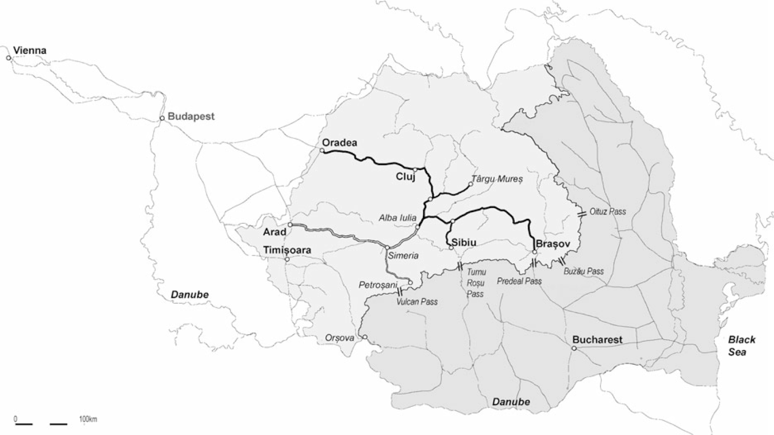
Obviously, besides the military objectives, economic ones were at the core of the state’s railway agenda. To a large degree, Transylvania’s relatively low level of economic development, compared to the rest of the Hapsburg Empire, is considered the result of the aristocracy’s refusal of any reforms that would have diminished their privileges. Hence, feudal relations persisted until the mid-nineteenth century. Before 1848, when serfdom was finally abolished, the aristocracy was exempted from paying taxes and was the only possessor of land. Moreover, the inhibition of certain industrial branches was caused by the abolition of internal trade frontiers, as a common market was created within the Austrian Empire in 1850. The competition from the more advanced Austrian products threatened especially the processing industry of textiles, leader, machine building, and chemicals. In turn, the Habsburg market determined the areas in which Transylvania’s industry would develop. Thus, metal and coal mining, steel production, and forestry were the main branches, with direct Austrian and Hungarian capital interests, as suppliers of raw material for their processing industries. This situation led historians to characterize the imperial policy in Transylvania as semicolonial. The province was seen as being transformed into one of the main markets for the Austrian and Hungarian industrial goods, while being one of their cheap raw material providers (Tóth-Gáspár Reference Tóth-Gáspár1964). The other essential reason for the state’s interest in the Transylvanian railways was the opportunity of securing its eastern markets by having improved access to the Danube and the Black Sea (figure 1).
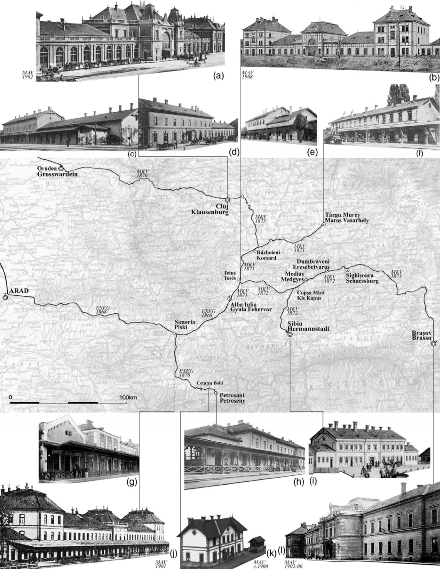
The Transylvanian railway network in context, about 1900.
Note: Grey areas: current territory of Romania; light grey area: the focus area of the present study—area of the Romania’s current territory, belonging to the Austro-Hungarian Empire before World War I; double-thick line: “the Imperial line” (Arad–Alba Iulia with the branch Simeria–Petroşani); thick line: “the Transylvanian line” (Oradea–Cluj–Braşov with the branches Războieni–Târgu Mureş and Copşa Mică–Sibiu).

As the state opened railway construction to private capital in 1854, various corporations became interested in the construction of Transylvanian railways. This was motivated both by the potential of transit itineraries to the Danube and the Black Sea and by the prospects for extracting and exporting the region’s rich underground resources. Before the advent of railways, conveying southern Transylvania’s iron ores from the extracting to the processing venues raised serious difficulties. According to L. Vajda, before the late 1860s railway advent and subsequent development of coal mining in the Jiu Valley, the massive presence of wood allowed the local iron industry to avoid merely exporting the iron ore. Although discovered at the end of the eighteenth century and sporadically exploited at surface, proper means of transportation were indispensable to any profitable exploitation of the rich deposits (Vajda Reference Vajda1964). The railways thus became not only the means for the south Transylvanian coal transportation but also one of its main consumers.
The railways from Vienna and Budapest reached Arad and Oradea in the late 1850s (figure 1). As the state’s resources were limited, the major Transylvanian towns’ elites initiated different projects by writing memoirs to the central administration, pleading for the advantages of one or the other trajectories. These long-lasting disputes were fostered by the fact that none of the towns could claim being Transylvania’s undisputable capital from all points of view (political, economic, cultural). While Alba Iulia was Transylvania’s major Habsburg stronghold and the principality’s capital before its conquest by the Habsburgs, Cluj, Sibiu, and Braşov were at least as important for political and/or for economic reasons (figure 1). Cluj was the center of the Hungarian aristocracy (owners of large estates) competing for the political capital status with Sibiu, the center of the Saxon aristocracy. In turn, Braşov was the center of the Saxon and Romanian bourgeoisie, mainly traders and industrialists, challenging Sibiu for primacy over the trade with the Romanian principalities. Thus, the railway issue became an argument in the struggle for regional prominence of one or the other cities, and implicitly of one or the other nations.
“A Continuous Chain of Unsuccessful Projects”
From the mid-1830s to the mid-1860s, different initiatives succeeded each other, either from local groups, trying to raise the necessary capital, or state-born, making preliminary studies for different trajectories, however, with no concrete results. These ignited countless polemics in the press and in the political circles (Strach Reference Strach1898, 3: 166; Vajda Reference Vajda1971). Contemporaries even spoke of the Transylvanian railway issue as “a continuous chain of unsuccessful projects” (Strach Reference Strach1898, 3: 125).
In 1856, the government commissioned Ober-Inspector Schnirch to undertake trajectory research in Transylvania. Out of three proposed trajectories, considering the importance of the eventual prolongation to the Black Sea, the trajectory Arad–Braşov–Buzău Pass was recognized as the most efficient (ibid.: 125). Simultaneously, Colonel Bils was sent to the main Transylvanian towns (Cluj, Targu Mureş, Braşov, Alba Iulia, Sebeş, Sibiu) to discuss the military implications of railway building with the local authorities (Mureşanu Reference Mureşanu1974). Still in 1856, the Viennese group Rothschild (main shareholder in the powerful company Staatseisenbahngesellschaft, henceforth StEG) received the license for a railway from Arad into Transylvania, and through the Buzău Pass to the Danube and the Black Sea (figure 1). But the Romanian authorities preferred a border connection either through the Vulcan Pass, or on the Danube, at Orşova. They rejected the Buzău Pass connection, as it would have bypassed Bucharest, at the same time advocating an Austrian link that would have passed as much as possible on the Romanian territory. As the Vulcan Pass implied too many constructive difficulties and Orşova was rejected by the Austrian government for strategic reasons (for being too close to the Turkish fortress Ada Kaleh), the Rothschild group gave up their project (Mureşanu Reference Mureşanu1974; Turnock Reference Turnock1999: 13). As mentioned by D. Turnock, the Romanian state was keen on having commercial links with the Habsburg Empire, to show Bismarck that Prussia did not have a monopoly of railway construction in the Romanian Principalities. This was an especially sensitive issue, since the 1871 scandal, generated by the Roman–Galaţi–Bucharest line. At that time, Bismarck had asked Turkey as sovereign power to intervene in favor of the contested German concessionary Strousberg (Turnock Reference Turnock1999: 13).
Given the fund-raising difficulties and the competing private proposals, in 1860, the government sent the famous Austrian railway engineer Karl von Ghega to study an efficient way of combining the different projects into a single one. He decided that “if Transylvania was to have but one railway line, then the Oradea–Cluj–Braşov–Buzău Pass would best serve the country’s interests,” but that it was at all costs also necessary to join Sibiu with Cluj by a railway in the Mureş Valley (Strach Reference Strach1898, 3: 125).
Conversely, in 1861, two license applications favored the south of Transylvania. The Braşov Mine and Foundry Corporation (Kronstadter Bergbau und Huttenaktienverein) applied for a railway from Arad through the Iron Gates of Transylvania onto Haţeg, to be prolonged by a “coal railway” onto Petroşani in the Jiu Valley (figure 1); the main line was supposed to continue to Simeria–Alba Iulia–Braşov and across the border through Buzău Pass. Simultaneously with this proposal, that would have left Sibiu beside the line, the Sibiu Railway Committee applied for a line from Arad through Sibiu, to the Romanian border at Turnu Roşu (ibid.). As they could not agree on a joint venture, the Braşov Corporation tried to interest Tisa Region Railway Company (Theiss Eisenbahn Gesellschaft, henceforth TEG) in a line through the Mureş Valley, then to Sibiu and to the Romanian border (with a possible later ramification to Alba Iulia and Cluj). With mainly Austrian capital, TEG had already built the railway lines to Arad and Oradea (both open in 1858) and owned an extensive network in the Hungarian plain. However, the financial difficulties of TEG condemned this attempt to an impasse (Vajda Reference Vajda1971: 126).
Nevertheless, as in December 1863, the state issued a law project for a Transylvanian railway, five offers were received for the line Arad–Sibiu–Turnu Roşu, among which, the TEG even presented a complete project. The law, however, was not voted (Strach Reference Strach1898, 3: 166).
“The Imperial Line” Versus “the Transylvanian Line”
In 1863–64, the Transylvanian provincial parliament, recently moved from Cluj to Sibiu, dedicated several sessions to the railway issue. There was strong opposition between the Sibiu and the Braşov members, as to the realization of the railway junction with Romania through either Sibiu or Braşov (Retegan Reference Retegan1974: 333). In his 1865 Transylvania, Charles Boner, British expert appointed to advise on the most feasible trajectory, summarizes the two main options’ pros and cons. Notably, he compares “the Imperial (Government) line” to “the Transylvanian line” (figure 1):
On the railway question, as on every other, national rivalry manifested itself at once. The Hungarians were desirous that the new line should enter the province by Cluj (Hungarian), which would have given this town great additional importance, and … have had the effect of rendering Sibiu (Saxon) a second-rate town.… The Government line was intended to join the great European railways at Arad, and thence go to Sibiu, leaving Transylvania by the Turnu Roşu Pass, where it would meet the Turkish line to Bucharest and Constanţa. Thus, Transylvania, except for Sibiu and its neighbourhood, would have benefited little, as the line left the land almost as soon as it entered it. The Oradea–Cluj–Braşov route had the great advantage of traversing the whole province, which would go far to compensate for the costliness of the undertaking, owing to the difficulties of the route. If assistance were to be rendered to Transylvania, therefore, this line seemed the one best adapted for doing so. (Boner Reference Boner1865: 602–03)
Despite the military and economical pros and cons, all controversies became meaningless as soon as the capital could be raised for either of the two lines. Because the private capital was lacking and as “the Imperial” line was more economic, through the law of November 29, 1864, the state took over the Arad–Sibiu–Turnu Roşu line, with a ramification to Cluj. Reacting to the 1863 drought, the government could obtain cheap labor in exchange for subsistence means for an impoverished population (Strach Reference Strach1898, 3: 167; Vajda Reference Vajda1971: 289). Thus, it was finally neither the strategic, nor the commercial objectives that determined the state to take action, but rather the critical state of social welfare. Moreover, in 1864, the Transylvanian railway was not the only case in which the earthworks were attacked on the state’s expense as response to an emergency (Strach Reference Strach1898, 12: 19).
Subsequently, two contractors offered to undertake the works and the winner was the London firm Pickering (Strach Reference Strach1898, 3: 166–67; Vajda Reference Vajda1971: 289–90). Meanwhile, reassured by the trunk line to be constructed along the Mureş Valley, the Braşov Corporation applied for the Jiu Valley branch license, as one of the major coal field owners there (Gesuch 1864). This compelled Pickering to be ready to undertake the branch line construction too, had they wanted to secure their contractor position. At the same time, the state gave the Braşov Corporation a delay of six months (starting with February 19, 1865) for studying both the trunk and the branch lines, aiming to take over their construction and operation. Meanwhile, in July 1865, the Imperial Senate voted the continuation of the line Arad–Vinţu de Jos toward Sibiu and to Turnu Roşu, at the Romanian border (Retegan Reference Retegan1974: 336). Subsequently, the law of August 10, 1865 modified the scheme by including the Jiu Valley branch line. Under the new conditions, the firm Pickering lost their interest in the project and withdrew. Finally, on August 18, 1866, the Braşov Corporation received the concession for the construction of both the Arad–Alba Iulia and the Simeria–Petroşani lines (Concessions-Urkunde 1866).
Following over two decades of debate, within a five-year span both of the competing lines and their branches were finally open as state-guaranteed private enterprises. “The Government line” opened first: in 1868 the trunk line Arad–Alba Iulia, followed by the branch Simeria–Petroşani in 1870. The trunk and branch lines were granted in 1866 to a private consortium that formed the First Transylvanian Railway Society (Erste Siebenbürger Eisenbahn Gesellschaft, henceforth ESEG) in 1867 (Concessions-Urkunde 1866; Statuten 1867). The works were entrusted to the Viennese contractors Gebrüder Klein und Sepper (Additional-Uebereinkommen 1867).
At a second stage, after the 1867 Dualist Compromise established Hungary’s autonomy within the Dualist Monarchy, and Transylvania’s incorporation into Hungary, a new plan for the railway system was drafted under Minister Mikó Imre in 1867. The latter indicated the Oradea–Buzău Pass trajectory—"the Transylvanian line”—as a priority (Strach Reference Strach1898, 12: 34). In 1868 the construction of “the Transylvanian line” with its branches was granted by the State to the Society of the Eastern Hungarian Railways (Hung.: Magyar Keleti Vasúttársaság, henceforth MKV). Entrusted initially to the British contractors Warring Brothers & Eckersley, the lines of the MKV opened in several stages between 1870 and 1873, not before severe delays and financial complications caused by the latter company. These required the state’s intervention to salvage the project: Oradea–Cluj opened in 1870; Alba Iulia–Târgu Mureş in 1871; Teiuş–Mediaş and Mediaş–Sighişoara in 1872; Sighişoara–Braşov and Cluj–Războieni in 1873 (Strach Reference Strach1898, 12: 35–38) (figure 1). Because of the company’s financial problems, the lines of the MKV were among the first to be nationalized in 1876 and henceforth managed by the Hungarian State Railways (Magyar Államvasutak, henceforth MAV).
Mapping Architecture: The Image of the Railway Territory
Highlighting patterns of territorial coherence, through the architecture of reception buildings, presumes that the latter operate synecdochally in the collective imagination as pars pro toto. Firstly, the reception building stands symbolically not only for the entire railway station but also for the town or village for which it serves as an entrance; secondly, due to their prominence among the other railway (infra)structures, the reception buildings also symbolize the entire “machine ensemble” as W. Schivelbusch memorably called the railway (Schivelbusch Reference Schivelbusch1986: 16–32).
Before World War I, two main architectural “layers” were built along the Transylvanian railway lines: the original layer, belonging to the private concessions phase, and the postnationalization layer of the state railway administration. Because many of the earliest buildings have been replaced at different times, these layers remain largely unknown and are often the object of dating confusions. The original line construction date is sometimes indicated as the building date of the second reception building. Moreover, misunderstanding of the architectural phases layering often leads to renovating extant buildings according to color schemes and plastic vocabularies belonging to different historic phases.
In mathematical linguistics, to map is to perform an associative operation, connecting two sets of data, namely the domain and the range. By mapping, we understand identifying significant relationships between territorial hierarchies (domain) and architectural characteristics of railway buildings (range). The article does not investigate all architectural aspects, such as functional distribution, structural, and constructive features, but focuses on the relative size, volumetric configuration, and “style,” understood hereby as a specific vocabulary of exterior plastic choices.
Is there clear correspondence between the architectural style of railway edifices and established/planned railway network and territorial hierarchies? Which are the national/regional/local visions and narratives implicitly embodied in the architectural language of the railway, in the stylistic choices of state and private railway agency? How can a reading of railway architecture as place markers inform an understanding of state-building projects and processes? An architectural analysis of the two lines in point will reveal both intrinsic and relative, both conceptual and stylistic contrasts along the “Imperial” (ESEG) and “Transylvanian” (MKV) railway lines. The iconographic study takes a journey’s form. The chronologic and stylistic sequences are rendered as encountered by a railway traveler, journeying eastward, first in the 1870s, then before World War I, from Vienna onto what was then the Romanian border.
From Vienna to Budapest: Contrasts and Affinities in Private and State Stylistic Choices
The advent of railways in the Habsburg Empire during the 1840s, under state-guaranteed, private-capital investments, was stylistically marked by neoclassicism. During the early 1850s, a more picturesque, Romanticist style, reminiscent of medieval architecture, came to the fore, still in the frame of private undertakings. This shift from neoclassicism to Romanesque and gothic revivals around the middle of the nineteenth century was a typical evolution in many European regions. The leaning toward the medieval, rather than the classic architectural language, had to do with the nineteenth-century emergence of national identity constructions throughout Europe. A romanticized view of local history, rather than the universal and timeless canons, associated with classicism, tended to be favored. If neoclassicism was the French Revolution and the Napoleonic Empire style, its hegemonic and universalizing force was contested by the emerging national states, gearing their stylistic preferences toward the medieval. In railway architecture, this shift is visible for instance in the image of pioneering stations, such as Philip Hardwick’s Doric propylaea (1838) at London’s Euston station and, respectively, Brunel’s Paddington Station (1858).
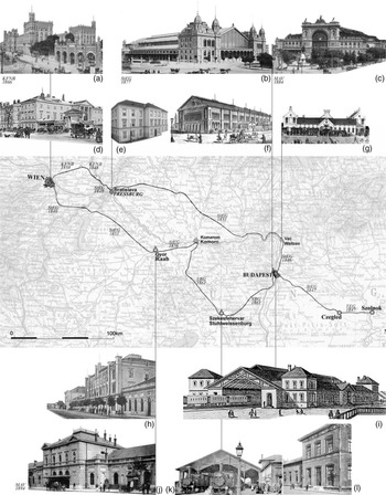
In Vienna, while the first railway lines were private investments, the same shift from neoclassicism to romanticism is traceable. This is apparent comparing the buildings by Anton Jüngling (1839; figure 2d), respectively by Theodor Hoffmann (1866; figure 2a), for the headquarters of the Emperor Ferdinand Northern Railway (Kaiser Ferdinands Nordbahn, henceforth KFNB) (Kubinszky Reference Kubinszky1986: 31). Likewise, the 1840s StEG buildings of the Pest–Vác line (first railway on Hungarian territory) were in neoclassical style (figure 2f, 2g). Conversely, the 1850s buildings of the same company on the Vienna–Gyor line (figure 2h) already shifted toward the more fashionable, medievalist ornamental vocabulary.
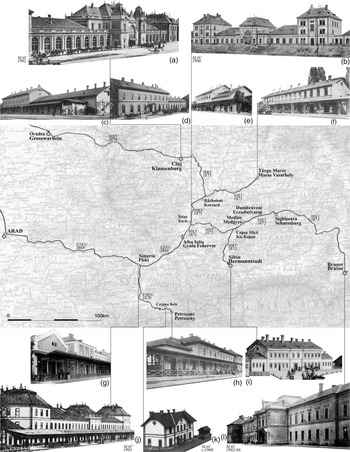
Mapping of railway architecture from Vienna to Budapest, before World War I.
Note: Map: Railway connections toward Transylvania, at the time of the trunk Transylvanian lines opening (1868–73), indicating the operating company and the opening year.
Sources: Base map: Detail from Stielers’ Hand Atlas, 1904. Picture rows: Author’s processing of historic postcards from the collections of Cluj County Library, Cluj Central University Library, and Wikipedia Public Domain.

In Budapest, still under private ownership, the new Western station of the other capital of the dualist empire (as of 1867) replaced the original neoclassicist building of StEG in 1877 (1846). The new, extant station was a state-of-the-art romantic building, designed by the company engineer August de Serres-Wieczffinski (1841–1900) and built by the Eiffel group (figure 2b). Conversely, following the nationalization of MKV in 1876 and of TEG in 1880, the 1884 Eastern station of Budapest was erected in eclectic (Renaissance reminiscent) style, designed by architect Gyula Rochlitz and engineer János Feketeházy (figure 2c). The same shift is noticeable at the MAV 1894 extension of the former StEG station, Gyor. Thus, stylistic analysis not only reveals contrasts between the privately owned and the state-owned stations (such as Budapest Eastern) but also the earlier changing stylistic preferences for the privately owned lines. Significantly, the latter followed the aesthetic ideologies at work in the state-built production.
From Budapest to Oradea, Arad and Alba Iulia: Eastward and Peripheral Declinations
For Hungary and Transylvania, the term “romanticism” has been used to characterize the architectural production from the 1840s until the late 1860s (Zádor Reference Zádor1985: 9). In the field of railway architectural history, the term “romantic” has been used in relation to the TEG, as well as to the ESEG edifices (Horváth and Kubinszky Reference Horváth and Mihaly1998). However, as A. Zádor notes, in the former Habsburg, then Austro-Hungarian Empire, both classicism and romanticism “occurred rather late and developed rather rapidly.” This explains the frequent juxtaposition and marked influence of styles on one another, especially the fact that “the Romantic idiom [was] often intermingled with Classicist elements” (Zádor Reference Zádor1985: 8–9). The medieval-romanticist style was favored in Transylvania during the 1850s, significantly both in state and private architecture. Generally, by the 1860s, the medievalist vocabulary became obsolete and started being superseded by neo-renaissance and eclecticism. Nonetheless, in many regions, especially northern and central Europe, it continued to inform industrial architecture in general and railway stations in particular, well after 1870, most likely due to its appeal to the developing nationalist ideologies.
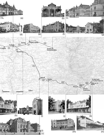
The eclectic romanticist ESEG buildings featured, therefore, both classicist and Middle Age–reminiscent elements. Classicist traits such as the symmetrical composition of volumes, with three avant-corps, regularly spaced window bays and the use of pediments, as recurrent architectural motive, juxtaposed to nonclassicist elements. The latter included arcaded cornices, projecting corner pilasters, corner chamfers with lark’s tongue end, consoled corner turrets, accolade-shaped window frames, geminated windows, and the X-shaped anchor plates. The ESEG trunk line buildings displayed a coherent constructive and ornamental system, the degree of complexity thereof ordered according to station class (figure 3d–g, 3h–k, 3m–n).
Mapping of railway architecture from Szolnok to Alba Iulia, before World War I.
Note: Map: Railway connections toward Transylvania, at the time of the trunk Transylvanian lines opening (1868–73), indicating the operating company and the opening year.Sources: Base map: Detail from Stielers’ Hand Atlas, 1904. Picture rows: Author’s processing of historic postcards from the collections of Cluj County Library, Cluj Central University Library, and Wikipedia Public Domain.

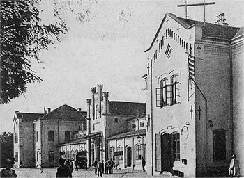
The most elaborated elements were the three-stepped crenellated fronts at the entrance volume of the Oradea and Arad reception buildings (figure 3g, 3i; figure 4). Further, the most frequent and, therefore, characteristic element was the pediment with arcaded cornice on stepped consoles, a freestyle reminiscence of the Romanesque arcaded cornices. The pediment featured a rhomboidal attic window and its corners were marked by the slight widening of the projecting corner pilasters. At Arad, Alba Iulia and Vinţu de Jos the latter took the shape of small octagonal corner turrets, further alluding to medieval fortifications. Even if much simplified, the pediment decorated all reception building classes, including the smaller ones of the third and fourth classes (figure 3e, 3j, 3m). Another reference to the (late) Middle Ages was the segmental-arched window form.
Finally, through a consistent, albeit differentiated application of a coherent decorative vocabulary, the ESEG edifices configured an architectural archipelago, with undeniable aesthetic, hence representative, qualities. Despite being a private undertaking, the ESEG’s stylistic choices were akin to the 1850s–1860s pairing of the Middle Ages–reminiscent aesthetic with nationalist ideals.
Despite this stylistic unity, however, as railways advanced eastward, contrasts can be noticed, revealing underlying center-periphery hierarchies and implicitly confirming some historians’ view of the empire’s most marginal regions as semicolonial territories (Tóth-Gáspár Reference Tóth-Gáspár1964). For example, one may compare the buildings of ESEG, to those of TEG’s or to those of the Southern Railways (Südbahn-Gesellschaft, henceforth SBG). Elegant, three-bay wooden sheds covered the tracks at some of the late-1850s TEG buildings (e.g., Szolnok, Püspökladány, Kassa, Debrecen, Arad [figure 3b]), as well as at the early-1860s SBG buildings (e.g., Buda South and Székesfehérvár [figure 2i–k]). In turn, the ESEG end or junction stations were only provided with simple canopies over the first platform (figure 3k, 3n).
From Simeria to Petroşani: Territorial Hierarchy through Trunk and Branch Line Contrasts
Quite different was the original situation along the ESEG branch line Simeria–Petroşani (open in 1870). From the very outset, in the 1864 Application for Concession, the ESEG branch line was intended to be built as low cost as possible. Among other constructive-economical stipulations, the document claimed precisely that the branch line edifices would be most basic (“die Gebäude höchst einfach zu errichten”) (Gesuch 1864). The branch line’s end station Petroşani was far less elaborated than the trunk line’s first and even second-class buildings, employed at Alba Iulia and Vinţu de Jos, respectively (figure 5h; figure 3n, 3k). For the branch line buildings, the romantic decorative idiom was given up (figure 5g–h). The arcaded cornices were replaced by basic projecting roof eaves and the pediments became simple projecting roof gables. The only reminders of the original idiom were the plain pilasters, giving some rhythm to the facades of the projecting volumes. Even the small height difference between the central volume and the lateral ones, conferring a slight note of elegance to Simeria’s reception building (figure 5g), was cancelled in Petroşani (figure 5h). Furthermore, the iron columns and main beam supporting the platform’s canopy in the trunk line’s first-, second-, and third-class stations were replaced in Petroşani by more modest, wooden replicas. The arched openings were also eliminated. Utter simplification led, therefore, toward what could be called a penurious appearance of the branch line’s first architectural layer.
The mapping in figure 5 reveals a stylistic contrast between the basic edifices of the ESEG branch line and those of the trunk line. This contrast was primarily motivated by the concessionary society’s economy concerns and by a down-looking, colonial-like attitude toward the remote mining region (Purcar Reference Purcar2009a). Arguably, this attitude did not meet any opposition from either central or local authorities, during this initial railway development phase.
From Oradea to Cluj and Braşov: Private Line Contrasts
Compared to the ESEG’s, the MKV edifices displayed less elaborated volumetric configurations, a visibly more sober, even penurious architectural language, almost devoid of ornaments (figure 5c–f, 5i). In another study we defined the “obligatory” point stations as the more prominent settlements along the projected railway route, which were neither end nor junction points. Nonetheless, these settlements constituted necessary stops both for water filling and due to their regional role as production and/or marketplaces. Within the station hierarchy, the “obligatory” points category is followed by intermediary stations, owing their status to a convenient location along the trajectory, thus allowing for relatively even intervals between successive stations. These localities represented a compromise between the fueling requirements of locomotives and the need for providing railway access to the trajectory’s hinterlands and their natural resources. These intermediary stations subdivided the otherwise too long distance (operation-wise) between the “obligatory” points (Purcar Reference Purcar2009b: 82–88).
This functional classification of stations, depending on the network role and on settlement importance, received contrasting interpretations for ESEG and MKV. The ESEG stations were differentiated into five classes (including the halts), each class presenting individualized and easily recognizable volumetric configurations. Through the interplay of the projecting central and lateral wings and the different heights of the pediment hip roofs, a nuanced, yet stylistically unified architectural image was achieved. These buildings thus stood as recurrent visual markers of both territorial coherence and hierarchy (figure 3I, 3j–k, 3m–n).
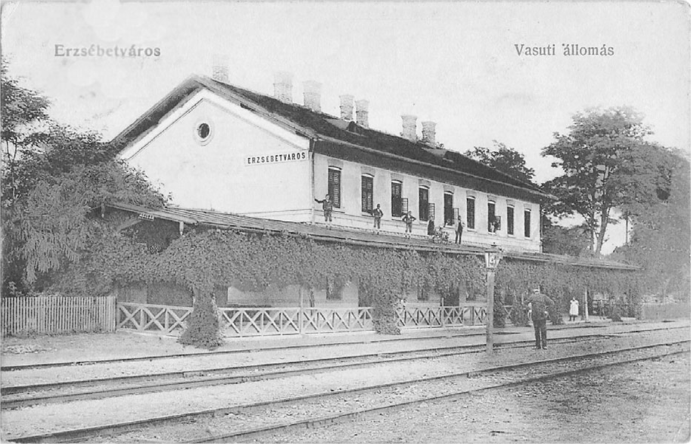
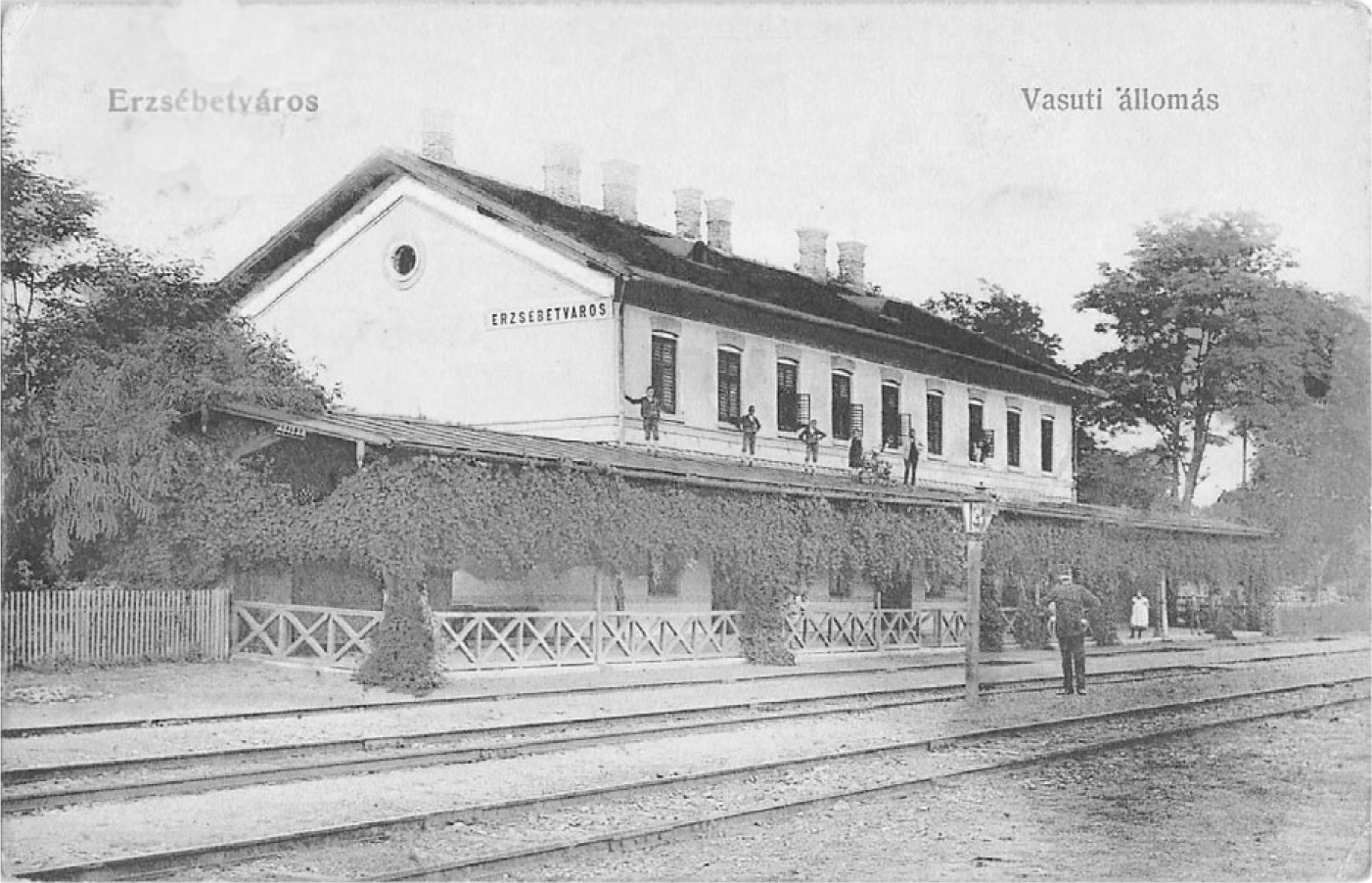
In contrast, the MKV stations adopted a more economical albeit an arguably more modern approach: sameness was preferred over diversity and over individualization of the station classes. MKV’s volumetric configurations were plain juxtapositions, rather than articulations. If lateral wings were present, they had the same width as the central body and the same simple gable roofs, with the ridge parallel to the tracks (figure 5c–f, 5i). These buildings were thus virtually expandable along the tracks, without the initial construction needing significant adaptations, clearly a more modern principle than the static configurations of TEG and ESEG. At the same time, MKV’s stations symbolically blurred territorial hierarchy: at junction points—villages with no particular territorial function (Teiuş, Războieni, Copşa Mică [figure 5e]), the passenger buildings were identical with those of the “obligatory” points and intermediary stations—small regional head towns (Aiud, Mediaş, Dumbrăveni, Sighişoara [figure 6]) and quasiidentical with those of the terminus stations (Cluj, Târgu Mureş, Sibiu, Braşov [figure 5c–d, 5f, 5i).
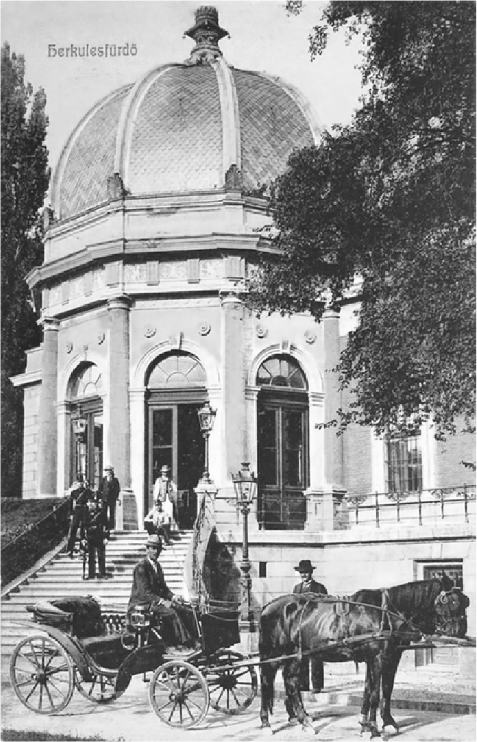
It has been argued that giving up the romantic decorative idiom along the MKV was a proof of sensitivity toward the more recent architectural trends (Horváth and Kubinszky Reference Horváth and Mihaly1998). Indeed, as mentioned in the preceding text, by the early 1870, in the Hungarian part of the dual monarchy, architectural romanticism started to give way to eclecticism (Zádor Reference Zádor1985: 8–9). At the same time, by 1870, the date of the ESEG branch line opening, the preference for an eclectic language, still foremost inspired by the Renaissance, was gaining prominence. This new taste was increasingly present in the contemporary railway architecture as well. Remarkable in this respect is the subtly elaborate station at the thermal-water resort Herculane (open 1886) on the Timişoara–Caransebeş–Orşova line (1879) of StEG (figure 7). Against this background, we argue that the plastic expression of the MKV buildings was only partly motivated by concerns of adopting a more up-to-date architectural vocabulary.
Furthermore, another contrast was introduced at the MKV larger stations, between the town- and trackside façades. In Cluj as well as Sibiu and probably Braşov too, the town façade of the reception building (figure 5d, 5i) was adorned with classicist window and door frames with oversized keystones; conversely, on the trackside façade (figure 5c), a simplified plastic vocabulary was deployed whereby, at the less visible upper floor, only the architraves and window parapets were expressed through plain reliefs. Unlike the unified treatment of the ESEG trunk line buildings, on the MKV, façades were differentiated between the main towns (Cluj, Braşov, Sibiu [figure 5d, 5i]) and the other stations, including the branch endpoint, Târgu Mureş (figure 5f). The latter had a utilitarian, industrial aspect, highlighted by the exposed-brick segmental arches, the intermediary and roof cornices, as the only façade decoration. Unlike the ESEG buildings’ narrow profiled cornice, a typically urban architectural detail, the MKV’s had projecting cornices, rather pertaining to the rural constructive vocabulary.
As the financial crisis of the early 1870s so strongly affected railway construction in the Hungarian part of the Dualist Empire, there was a stagnation until the beginning of the 1880s (Perner Reference Perner and Strach1898: 114). Nevertheless, the trunk Transylvanian lines had been already in function at the outburst of the 1873 crisis. The latter can, therefore, hardly be blamed for the relatively inferior architectural quality of the MKV buildings, compared to the slightly earlier ones of the ESEG.
The stylistic choices for the ESEG edifices followed a significant array of precedents, radiating from Vienna and Budapest. As the railways advanced outward from the two capitals, Vienna and Budapest, the westernmost peri-Transylvanian towns were reached through the lines of the TEG. The latter developed its extensive network during the second half of the 1850s. TEG had already opened the railway lines to Arad and Oradea via Szolnok, both in 1858, the two end towns having identical reception buildings. As noted by M. Kubinszky in a comprehensive review of Hungarian railway architecture, because TEG and ESEG belonged to the same bank consortium, it is likely that the same architectural designs were used. Kubinszky considers that, compared to the TEG, the SBG, or the ESEG, the edifices of the other private companies active in the 1870s—including thus the MKV’s—were of inferior architectural quality (Kubinszky Reference Kubinszky and Kovács2000: 185–86).
Both the “Government” (ESEG) and the “Transylvanian” (MKV) lines were realized as state-guaranteed concessions within similar contractual conditions. It seems, therefore, rational to conclude that the architectural quality differences (noticed both by contemporaries and by present-day historians) are the result of an absence of state exigencies regarding the architectural aspects, before the 1880s nationalisation wave.
National-Scale Hierarchy and Unity: The Second, State-Controlled Architectural Layer
Between the 1880s and World War I, the Transylvanian network increased especially through the addition of extra branch lines. This happened particularly after the 1880 and 1888 acts that regulated the construction of local railway lines, but also after the nationalization of important lines in the 1880s (Kubinszky Reference Kubinszky and Kovács2000: 114). Most of the vicinal lines were constructed by private companies but operated by the Hungarian State Railway Company (MAV). Although private line construction continued, it was increasingly controlled by the state, which would take over most of the lines after their construction. By the end of the nineteenth century, state railway construction was going in parallel with the private construction of local lines. Thus, the already verified type designs used along the state lines were deployed on many local private lines too. Remarkably then, as highlighted by M. Kubinszky, for the period between 1880 and World War I “[t]he architecture of local railway lines from different parts of the country and owned by different entities was the most uniform of all” (ibid.: 189).
Thus, a consistent second “layer” was added during this period. The architecture of the rapidly developing MAV adopted a classicist-eclectic image, with the distinctive feature of the interplay between plastered and brick surfaces. Typical were the brick rusticated corners, window and door frames, and the brickwork friezes and cornices, but also, in subsequent type projects, the exposed-brick walls were contrasted to the whitewash prefabricated ceramic ornaments. Two type project families were representative of the period, contributing to the unitary image of the railway network before World War I. On the one hand, there was the bulk of the modular, easily expandable type designs for the small stations along the local lines (e.g., Cetatea Bolii on the ESEG branch line [figure 5k]). On the other hand, there were the monumental, richly decorated new reception buildings of the important cities (figure 2a–c, 2j; figure 3a, 3c, 3l; figure 5a–b, 5j, 5l).
As noted in the preceding text, while MKV was already nationalized in 1876, ESEG passed under the MAV administration in 1884. Thus, under state ownership, almost all the important stations of the two studied lines received significantly larger and architecturally elaborate new reception buildings during the first years of the twentieth century. Only the initial ESEG endpoints, Alba Iulia and Petroşani, did not receive new buildings because in both cases the original ones were already relatively large with respect to the town’s size. At the same time, reception buildings were replaced both at line termini (for the ESEG: Arad, for the MKV: Oradea, Cluj, Braşov, Sibiu) and at the major junctions and railway works (ESEG: Simeria, MKV: Teiuş, Războieni). Type projects were used thereby and architect Pfaff Ferenc (1851–1913) was the most prominent railway station architect of the period.
Interestingly, between a rather short time span (1902–10), a variety of stylistic declinations was deployed at the reconstructed stations. While certain volumetric configurations, the sheer size and proportions make all these stations easily recognizable as signifiers of this state-controlled boost, visible efforts were made to differentiate them from each other. To which extent did municipalities, at least important ones, have a say therein too, it remains to be elucidated.
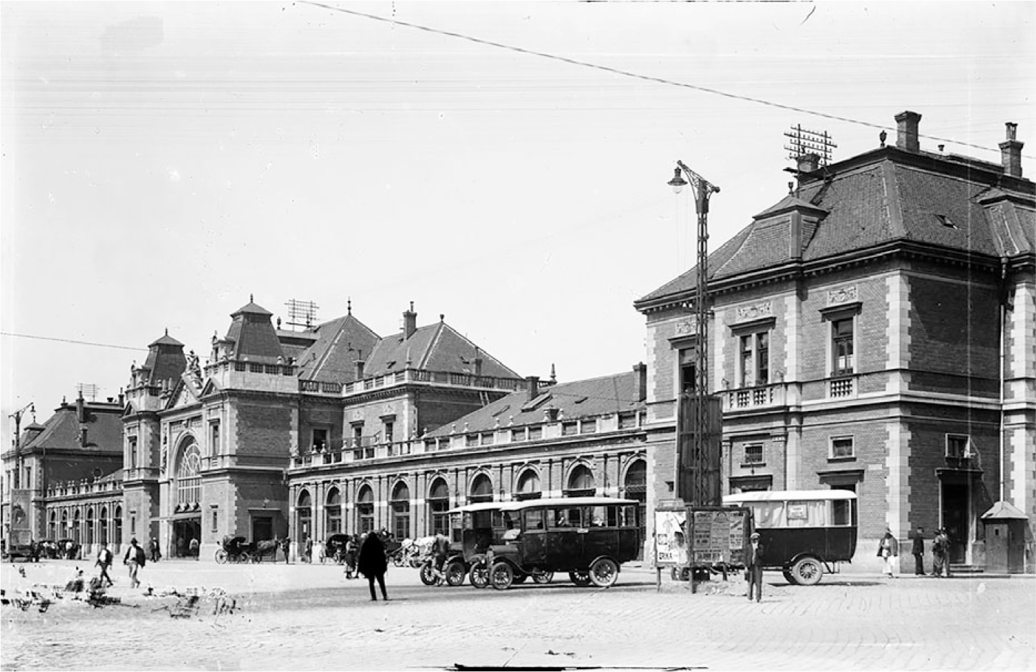
Nonetheless, a classicist architectural vocabulary, with entirely light-plastered, richly modeled facades, was preferred for the both reception buildings of Sibiu and Braşov (1902–6 [figure 5l ]), the two-competing south-Transylvanian main towns. The 1858 romanticist building at Oradea was considerably enlarged, while maintaining its original plastered, Middle Age–reminiscent style (1902; figure 3c)—perhaps a local preference for the nationalist ethos embedded in this stylistic idiom? An eclectic, Renaissance-reminiscent vocabulary in exposed brick was chosen for Cluj (1902; figure 5a; figure 8) and Arad (1910; figure 3l), the former configuring a reduced version of the 1884 Eastern Budapest station. At the junctions Teiuş (1908; figure 5b) and Simeria (1901; figure 5j), the fashionable secessionist elements combined with the dignity of classicist ones, sometimes displaying (Teiuş) the triumphal arch as central compositional motive; the Secessionist, flat and line-based ornamental vocabulary, was expressed through the contrast between the plastered walls and the exposed brickwork of the window and doorframes and other façade reliefs. Thus, by World War I, the image of the railway was clearly being considered in what had become an increasingly state-regulated design process. The “state effect” (Joyce and Mukerji 2017) was at once of coherence, prosperity, as well as diversity and hierarchy.
Arad. First passenger building, opened in 1858. View from the city side.
Note: Undated postcard.
Source: Cluj County Library.

Mapping of railway architecture from Oradea to Braşov and from Arad to Alba Iulia and Petroşani, before World War I.
Note: Map: Railway connections toward Transylvania, at the time of the trunk Transylvanian lines opening (1868–73), indicating the operating company and the opening year.
Sources: Base map: Detail from Stielers’ Hand Atlas, 1904. Picture rows: Author’s processing of historic postcards from the collections of Cluj County Library, Cluj Central University Library, Wikipedia Public Domain, and Strach Reference Strach1898.
Dumbrăveni. First passenger building opened in 1873. View from the track side.
Note: Undated postcard, before World War I.
Source: Cluj County Library.
Herculane. First passenger building opened in 1886. View from the city side.
Note: Undated postcard.
Source: Cluj County Library.

Cluj. Second passenger building opened in 1902. View from the city side.
Note: Undated interbellum postcard.
Source: Cluj County Library.

Railway Architecture in State-Building Discourse
Arguably, in the early-twentieth-century imagination, railway stations arguably held an exceptional place. This is perhaps best summarized by Proust’s insights: “Those peculiar places, railway stations … do not constitute, so to speak, a part of the surrounding town, but contain the essence of its personality, just as upon their signboards they bear its painted name” (Proust Reference Proust and Scott Moncrieff1934: 489–90; apud. Schivelbusch Reference Schivelbusch1986). Presuming this was a collective perception, rather than an exceptional individual’s, it is worth asking whether and in which terms it was also consciously cultivated within official discourse?
This section hence highlights the importance of the railway-architecture topic in the nineteenth-century historiographical discourse. History writing appears as an appropriate context to investigate how the self-aware state is “concerned to manufacture its own state effects through the conscious intervention of bureaucrats, experts of all sorts, and politicians” (Joyce and Mukerji Reference Joyce and Chandra2017: 3). The official historian’s practice is then, arguably, “keen to delineate the boundaries of state and to produce state effects” (ibid.).
As a representative case in point, we discuss the chapter contributed by Julius Perner, high-inspector of the Hungarian Royal State Railways, to the 1898 Geschichte der Eisenbahnen der Oesterreichisch-Ungarischen Monarchie (Perner Reference Perner and Strach1898). A twenty-volume railway history, covering all the empire’s regions, was published in 1898, celebrating Franz Joseph I’s 50 years of reign jubilee. The very fact of this editorial undertaking is illustrative of the railway’s importance within the late-nineteenth-century state-building agendas. Perner’s text is a summary of railway architectural development in the Hungarian part of the Dualist Empire, between 1867 and 1898. With its unsurprising apologetic bias, the chapter tries to balance between capital and marginal provinces, distinguishing among quality levels and emphasizing the state’s decisive role therein. Without naming them as such, three distinct historic phases emerge from the narrative: the pre-Ausgleich (1867) period, ruled by private capital development; the 1867 to late 1870s period, witnessing the incipient control of the Hungarian state over railway development, hampered by the 1870s economic crisis; and the 1880s to 1890s period, with the nationalization of many lines and the increased centralization of the railway system.
Perner’s deems the pre-Ausgleich period superior to the subsequent one. The 1850s to 1860s buildings of TEG (figure 3d–k, 3m–n) are commended as among the most outstanding Hungarian railway architecture, thanks to their “rich configuration and careful elaboration” (ibid.: 113). Conversely, between 1867 and the late 1870s, Perner reports a quality downfall in the Hungarian parts of the empire: “The first epoch of the reviving Hungarian entrepreneurship, was still behind the existing.” He deems that “in Hungary in particular, the Austrian engineers and architects first brought to expression characteristic building types, which had to be regarded as an important legacy” (ibid.: 113). Moreover, so crucial were the economic concerns triggered by the 1870s crisis, that a standstill occurred until the beginning of the 1880s. This unflattering evaluation is illustrated by the very MKV reception building at Cluj (figure 5c–d): “Even at the stations of larger provincial towns, the range of deployed resources rose little above the most modest requirements” (ibid.: 114).
Following this unfavorable initial period, however, a reversed trend is highlighted. Writing in the 1890s, Perner sees railway architecture as a catalyst for local building activities, through the provision of “stimulating and demanding” construction sites and architectural prototypes (ibid.: 123). The increased traffic requirements have led to the need of significant changes to station facilities, especially at junctions. Not only the termini would undergo these transformations but also important intermediary stations would await their “rejuvenation” (ibid.: 122).
Architectural quality had, indeed, become a relevant stake: “It is no longer utility that primarily determines [architectural] character, but one considers the significance that a large reception building may bestow on the architectural configuration of a provincial capital” (ibid.: 119–20). As the focus of converging trajectories and urban landmark, the station impacts the growth of its surroundings as well: “a destination for new roads, an impetus for building development in its neighbourhood” (ibid.: 120). But beyond these less quantifiable aspects, as an additional explanation is provided for the 1880s–90s upsurge. Perner points to the shifting perception about the relative cost of edifices within railway construction:
While in the past, the most severe economy was the guiding idea, in recent times one recognised the unfavourable consequences which this system has brought for the operation, the usability, and the expandability of the facilities. Besides, it was suggested that savings in civil engineering would not be of decisive importance for the new-line total cost, since they constitute too small a part of them. (ibid.: 121)
With such financial aspects assumed, touching upon cultural—read state-building—matters, seems all the more natural for Perner, in conclusion of his survey: “For building development specifically is not always dependent on the practical demands of a compelling necessity, but often expresses the reputation of individuals or corporations. It is determined by the need for beauty and the level of culture of individual places or countries” (ibid.: 122–23).
Having reviewed Perner’s assessments, we can compare them with the previously mentioned architectural analysis of Transylvanian stations. As summarized in the following text, one finds accordance between the two reading levels: the state-serving historiographical discourse, on the one hand, and the empiric evidence of station architecture, on the other hand.
Conclusions
A response to the departing research question—to which extent were railway stations conceived as architectural signifiers of territorial coherence—may now be formulated. In a first, network-construction phase (1860s–70s), territorial integration was only conceived of in transportation and economic terms; close-reading the architectural production along two major Transylvanian lines (ESEG and MKV) showed that the concessionary private societies built the lines without any specific requirements about their architectural image, as proved by their intrinsic and relative contrasts. The ESEG erected picturesque, if already stylistically obsolete, romanticist buildings along its trunk line and basic, rather penurious buildings along its remote mining branch line. The MKV differentiated between major town stations and the rest, not only in terms of size but also of plastic treatment; nevertheless, it maintained all along their lines a relatively lower-standard, economy-driven attitude, with regard to their architecture.
In a second, network development and consolidation phase (1880s–World War I), under the state administration of MAV, architecture was harnessed into a primary means of territorial integration. In the context of the 1896 celebration of the Hungarian Millennium and the ubiquitous urban renewal projects it occasioned, the railway system played a prominent role. The remodeling, enlargement, or complete replacement of numerous station edifices was a significant feature of these state-building efforts, conducted by a state railway administration, increasingly concerned about representation. Notwithstanding that the 1900s were high times of national construction throughout Europe, it can be argued that architecture was a foremost representation instrument for a state railway administration that gradually became, as elsewhere, “a state within a state.” Railway architecture is a quintessential component of the Belle Époque, embodying our present-day positive, perhaps idealized, collective image thereof. It conveyed its representativity through increased public amenity using more generous spaces, safer connections, and functional diversity, but also through monumentality and state-of-the-art architectural vocabularies, displaying both stylistic unity and individual declinations.
The result of one-and-a-half centuries of evolution, the contemporary landscape of railway architecture is best described by the notion of palimpsest (Purcar Reference Purcar2009b: 270). In few places, the original architectural layer has been entirely preserved and restored. Mostly however, there have been additions, (partial) replacements, and transformations, so that the current situation presents itself as a multilayered built document, a palimpsest of overlapping fragments. Lacking sufficient in-depth studies, one finds erroneous information in literature, but also ill-matched renewal interventions, caused by the misunderstanding of the historical layering of this (yet far from acknowledged and assumed) architectural heritage. Rather than exercising their state-building and territorial-coherence potential, many of the present-day Romanian railways have become fragile objects in the landscape. Instead of aligning landmarks along the line and thus appearing as a large-scale landmark, the railway seems to be rather withdrawing from the foreground. Sometimes it “keeps a low profile” in both the urban and the rural the landscape because of the severe decreasing of railway transport for both passengers and goods. Sometimes on the contrary, it exhibits ill-matched visual events, detracting from its own surviving fragile coherence and qualities. Ultimately, the railway edifices’ precarious landmark status expresses tension between intrinsic representative connotations and the lack of a coherent vision about what there could/should be represented.
This article is part of an ongoing research project, aiming to research the railway architecture as one key aspect of European cultural heritage. The study continues through the interwar modernizing developments, following Transylvania’s post–World War I union with Romania; through the temporary annexation of northern Transylvania by Hungary, between 1940 and 1944; through the intensive industrialization of Romania’s socialist period, followed by the depreciation of railway mobility after the 1989 fall of communism; and, finally, to the recent revival attempts, including but not limited to privatization and patrimonialization. Thereby, more facets of this genuinely cross-border, European heritage would be highlighted.