
Introduction
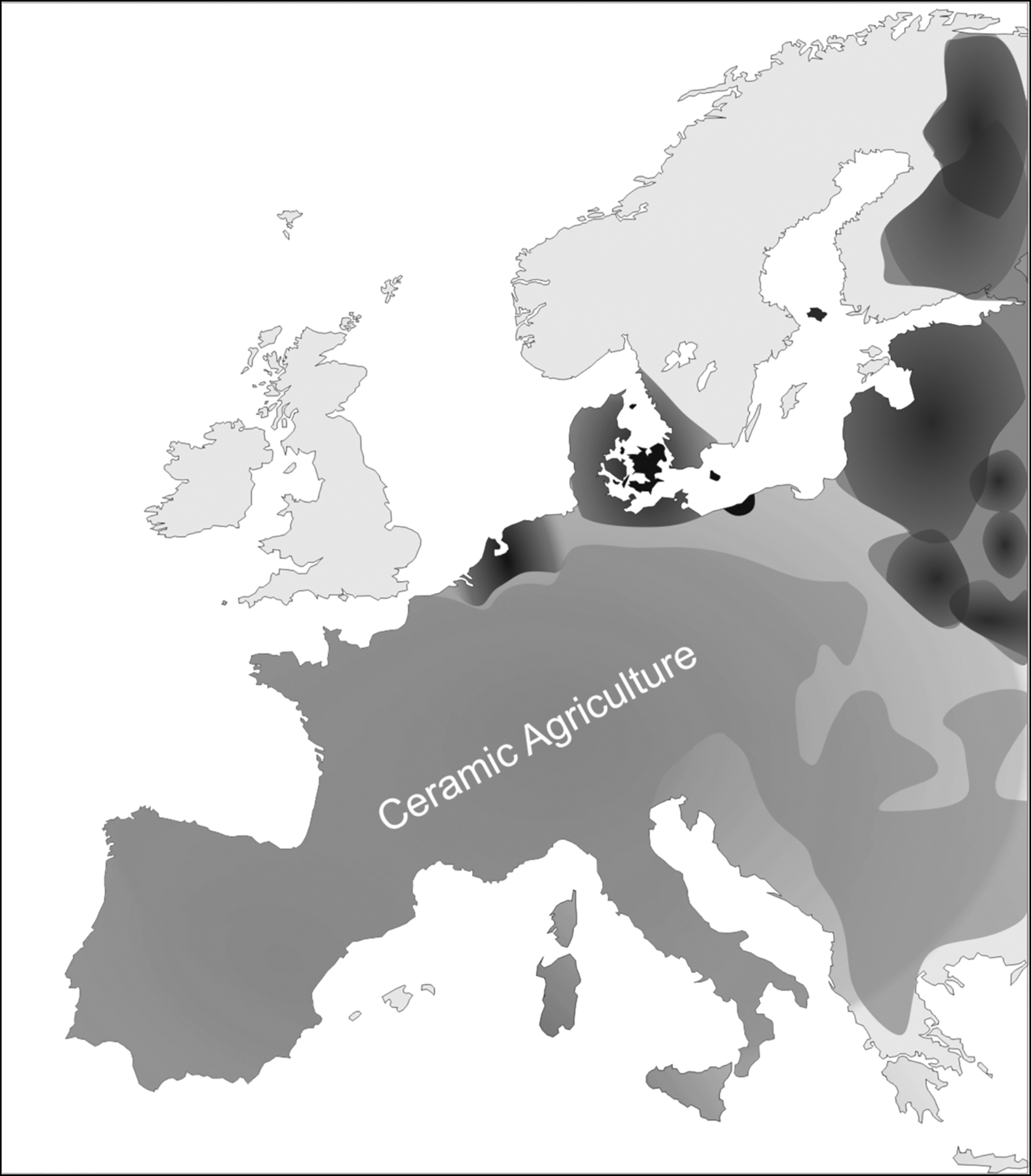
The Irish and British Mesolithic periods (c. 7700–4000/3800 and 9600–4100/3800 cal BC, respectively) are traditionally characterised as being aceramic. Evidence for the use of pottery vessels is absent within their respective Pleistocene and Early Holocene archaeological records, with the earliest pottery exclusively linked to the few centuries of change associated with the arrival of agriculture c. 4100–3800 cal BC (Whittle et al. Reference Whittle, Healy and Bayliss2011). While regional research has stressed the differences in human behaviour and environmental conditions between Britain and Ireland (e.g. Warren Reference Warren, Anderson-Whymark, Garrow and Sturt2015; Woodman Reference Woodman2015), this shared aceramicism has often been overlooked within research that assumes pottery to be an a priori facet of Neolithic life. This oversight becomes particularly acute within the fifth millennium cal BC, a period in which both agrarian and some hunter-gatherer communities around the North Sea Basin and Atlantic Façade produced pottery on a grand scale (Figure 1). But why was this technology not adopted by hunter-gatherers living in Britain and Ireland at this time?
Distribution of pottery across Europe at 4500 cal BC; black = pottery-producing hunter-gatherer groups; grey = pottery-producing farming group (figure by B. Elliott).

Although the obvious answer to this question is that they did not need pottery, it is now clear that ceramics were produced by a range of prehistoric hunter-gatherers (Jordan & Zvelebil Reference Jordan and Zvelebil2009). The very first known ceramic containers emerged among hunter-gatherers during the Late Pleistocene at sites in southern China (c. 18 000 cal BC; Wu et al. Reference Wu, Zhang, Goldberg, Cohen, Pan, Arpin and Bar-Yosef2012), the Russian Far East and Japan (c. 14 000 cal BC; Yanshina Reference Yanshina2017). In East Asia, pottery production increased dramatically at the start of the Holocene as it assumed a broader role in food preparation (Lucquin et al. Reference Lucquin2018). Pottery is first attested on hunter-gatherer sites east of the Ural Mountains at c. 7000 cal BC and in the Baltic by 5500 cal BC (Piezonka Reference Piezonka2015). During the late sixth and fifth millennia cal BC, hunter-gatherer pottery was produced in large quantities in the Low Countries (Swifterbant Culture), northern Germany and Denmark (Ertebølle Culture), and possibly northern France (La Hoguette/Limburg Culture) (Crombé Reference Crombé, Jordan and Zvelebil2009; Andersen Reference Andersen, Hartz, Lüth and Terberger2011; Raemaekers Reference Raemaekers, Hartz, Lüth and Terberger2011).
Evidence from North America, North and West Africa and the Arctic further confirms that ceramic-using hunter-gatherers were far from exceptional (Jordan & Zvelebil Reference Jordan and Zvelebil2009). Pottery was favoured by hunter-gatherers living within rich aquatic ecotones, and residue analysis of ceramics from hunter-gatherer sites across the globe indicates the importance of pottery in processing aquatic foods. Its specific role within these contexts, however, is debated. Taché and Craig (Reference Taché and Craig2015) suggest that pottery was used to render oils for storage and accumulation, while Hayden (Reference Hayden, Barnett and Hoopes1995) suggests that it was a prestige technology associated with feasting. Pottery, however, may also have been produced in anticipation of high returns from expected surpluses of aquatic resources (Lucquin et al. Reference Lucquin2018).
Evidently, these were socially structured groups inhabiting rich environments and who followed delayed-return economic models—investing energy, time and resources in subsistence strategies that deliver an increased economic pay-off at a later date. They did not live within marginal ecologies, nor were they on an inevitable trajectory to farming (Rice Reference Rice1999; Povlsen Reference Povlsen2013). Furthermore, foragers independently and repeatedly invented pottery (Jordan & Zvelebil Reference Jordan and Zvelebil2009). Thus, the technology was not universally acquired from adjacent farming groups. As such, research questions must now focus on why some groups and not others took up this technology. This article explores precisely this question by examining nine explanatory propositions for the apparent absence of ceramics in fifth-millennium cal BC Ireland and Britain. These are drawn from wider archaeological and anthropological scholarship on ceramic adoption within hunter-gatherer societies, although to our knowledge these have never been applied specifically to Britain and Ireland. The strength of each position will be assessed in relation to the archaeological record.
Proposition 1
‘Ceramic technologies were not adopted because there was no contact between Britain, Ireland, and continental Europe during the fifth millennium cal BC’
The supposed ‘cultural isolation’ of Britain and Ireland during their respective Late Mesolithic periods has been used to explain both the absence of the trapezoidal microlith forms (widely distributed across Northern and Western Europe) by 6500 BC (Jacobi Reference Jacobi1976) and the delayed adoption of agriculture (Sheridan Reference Sheridan, Finlayson and Warren2010). If ceramic technology dispersed via contact between neighbouring hunter-gatherer communities (Jordan & Zvelebil Reference Jordan and Zvelebil2009: 74), a lack of communication between populations in Ireland and Britain and their pottery-producing counterparts along the North Sea coast and Atlantic Façade could explain the absence of ceramics. This argument, however, is difficult to demonstrate archaeologically. The history of contact between Mesolithic Britain and mainland Europe stretches back into the Early Holocene, when lower sea levels allowed movement across Doggerland (Gaffney et al. Reference Gaffney, Fitch and Smith2009), and material culture and settlement patterns in Early Mesolithic Britain echo those seen elsewhere in Northern and Atlantic Europe (Warren Reference Warren, Anderson-Whymark, Garrow and Sturt2015; Sørensen et al. Reference Sørensen, Lübke, Groß, Milner, Conneller and Taylor2018). Despite the transformation of Doggerland into a series of archipelagos (c. 6500–7500 cal BC), the occurrence of hollow-based microlith forms within southern Britain and northern France during the French Middle Mesolithic (8000–6500 cal BC; Ghesquiére & Marchand Reference Ghesquière and Marchand2011) suggests that sea-level rise did not sever these links. Synchronicity between the Irish Early/Late Mesolithic and French ‘premiere/seconde’ transitions have been noted (Costa & Marchand Reference Costa and Marchand2006), and may indicate a cultural dialogue between these regions between 7000 and 6000 cal BC (Warren Reference Warren, Anderson-Whymark, Garrow and Sturt2015). This suggests a significant history of contact between Britain, Ireland and mainland Europe prior to 5000 cal BC.
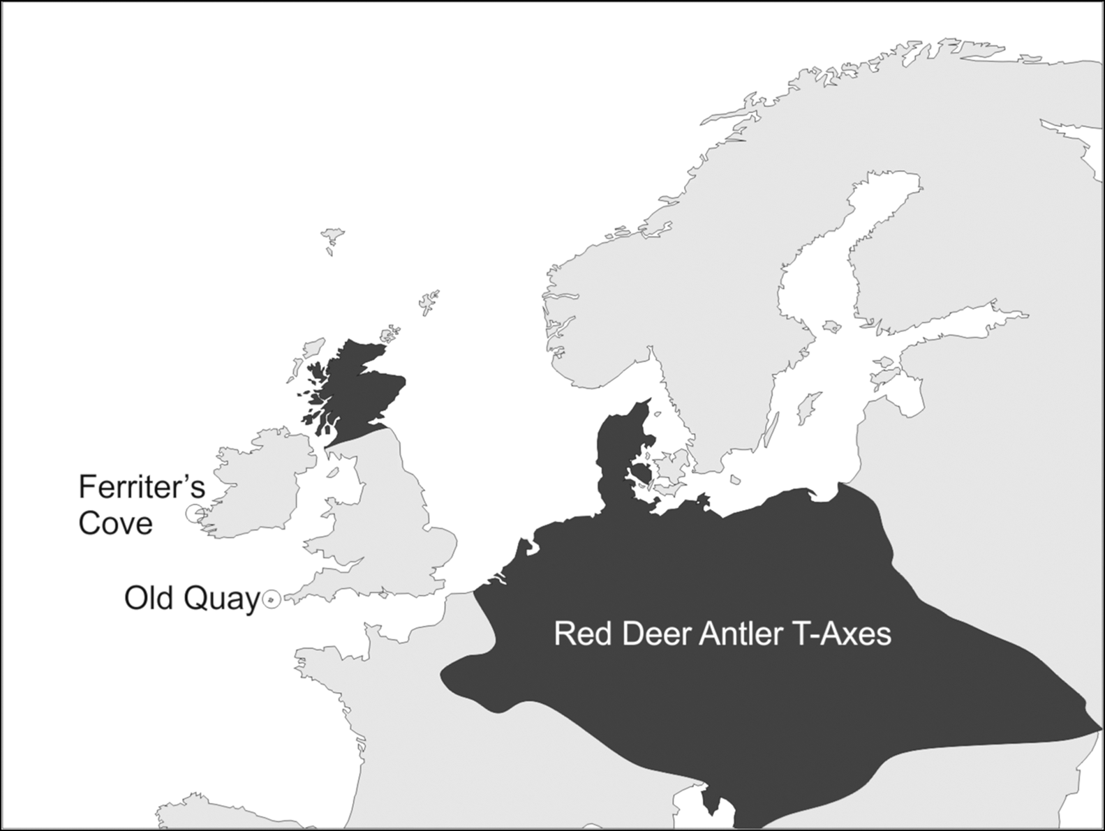
Although specific commonalities faded following the final inundation of Doggerland (c. 5500 cal BC; Sturt et al. Reference Sturt, Garrow and Bradley2013), the spread of red deer antler T-axes around the North Sea Basin (Elliott Reference Elliott2015) clearly demonstrates a continuance in the exchange of ideas (Figure 2). The earliest known T-axes from Scotland pre-date those of the Ceramic Ertebølle Culture in northern Germany and Denmark by several hundred years (Elliott Reference Elliott2015). Therefore, if T-axes represent a technological concept originating from Central European agricultural groups (Stapel et al. Reference Stapel, Schneid, Rosendahl, Pollmann and Baales2012), these were adopted more rapidly in Western and Eastern Scotland than in Southern Scandinavia. Meanwhile, an unusual trapezoidal/transversal microlith assemblage at Old Quay, Isles of Scilly (Anderson-Whymark et al. Reference Anderson-Whymark, Garrow and Sturt2015), which shows loose typological affinities to fifth-millennium BC microlith production in northern France and Belgium (Crombé Reference Crombé2015), further suggests movement of people between southern Britain and the Low Countries. Repeated reoccupation at Old Quay suggests that these contacts persisted for a considerable period of time (Sturt & Garrow Reference Sturt and Garrow2017: 131).
Distribution of red deer antler T-axes across Europe c. 4500 cal BC (figure by B. Elliott).

Evidence for contact between Ireland and mainland Europe varies. The modern Irish Cepaea nemoralis (terrestrial brown-lipped snail) shares haplotypes with Pyrenean or Cantabrian C. nemoralis, but not French or British snails. This possibly indicates direct contact facilitating the importation of the species during the late eighth/early seventh millennium cal BC (Carlsson et al. Reference Carlsson, Cross, McGinnity, Prodöhl and McDevitt2014). Warren's (Reference Warren, Anderson-Whymark, Garrow and Sturt2015) review of technological developments in Brittany and Ireland proposes potential Late Mesolithic links. Finally, contact between Ireland and mainland Europe in the fifth millennium is definitively demonstrated by the appearance of non-native cattle in Late Mesolithic contexts at Ferriter's Cove in County Kerry (Woodman et al. Reference Woodman, Anderson and Finlay1999).
Therefore, while the fifth-millennium archaeological record of Britain and Ireland is distinct from that of continental Europe, there is now tangible evidence for the continuity of connections observed in the earlier Mesolithic. Thus, populations in Britain and Ireland were in contact with their pottery-producing continental neighbours from c. 5000 cal BC onwards.
Proposition 2
‘Britain and Ireland lack the optimum environmental conditions for pottery adoption’
The early emergence of ceramic technologies has been linked to the productivity of environment types (Brown Reference Brown, van der Leeuw and Torrence1989)—specifically the rich marine ecotones associated with the emergence of incipient hunter-gatherer pottery in Japan (Craig et al. Reference Craig2013). There is strong evidence, however, of inhabitation of similar environments during the fifth millennium cal BC across Britain and Ireland. Intertidal zones were occupied throughout the Mesolithic in western Britain and coastal Ireland (Bonsall Reference Bonsall, Pollard and Morrison1996; Bell Reference Bell2007; Kador Reference Kador, Finlayson and Warren2010). Late Mesolithic Ireland is traditionally characterised by a focus of activity on inland waterway systems, which map onto aquatic ecotones (Little Reference Little2014). Occupation at coastal sites is often characterised by the presence of shell middens (Finlay et al. Reference Finlay2019) that indicate similar exploitation of marine and intertidal resources associated with the adoption of pottery by hunter-gatherers elsewhere.
Proposition 3
‘Hunter gatherers in Britain and Ireland lacked the “economic affluence” to necessitate ceramics’
Research on early pottery suggests a link between economically affluent hunter-gatherers and the adoption of ceramic technologies, and proposes a major role for pottery in processing surplus to create storable commodities (Hayden Reference Hayden, Barnett and Hoopes1995; Jordan & Zvelebil Reference Jordan and Zvelebil2009). It is, however, difficult to demonstrate material affluence within the archaeological record, due to the fundamentally relative nature of surplus production, given its dependence on the quantities of resources collected and the demand for the resource itself (Kuijt Reference Kuijt2009). The British and Irish coastal and lacustrine settlement patterns noted above offered populations the opportunity to exploit a range of resources in large quantities during the fifth millennium cal BC. Some aspects of the Irish Later Mesolithic, such as the fish traps from Clowanstown (5320–4720 cal BC), indicate the technological capacity to create seasonal surplus (Mossop Reference Mossop, McCartan, Schulting, Warren and Woodman2009). Pit digging, potentially indicating storage, is well documented throughout Mesolithic Britain and Ireland (Blinkhorn et al. Reference Blinkhorn, Lawton-Matthews, Warren, Achard-Corompt, Ghesquière and Ruquier2017). The archaeological record therefore indicates that Mesolithic populations had the ecological and technological potential to acquire material resources on a large scale, despite the difficulties in definitively identifying ‘surplus’ within their respective archaeological records.
Proposition 4
‘Pre-existing cooking and container technologies were deemed superior to ceramics in Britain and Ireland’
Ceramic containers allow for the storage, cooking and display of resources within hunter-gatherer societies. Aceramic forms of container technologies, however, share many of these functional attributes. It is therefore possible that pottery offered no discernible benefit to the fifth-millennium BC communities of Ireland and Britain. In the former, evidence for hunter-gatherer cooking technology can be considered relatively extensive and varied. The pot-boiler cooking method has, for example, been suggested for the Late Mesolithic site of Clonava (Little Reference Little2014). The storage and cooking of plants in pits and hearth features is known from Mesolithic contexts (c. 5500–3900 cal BC) at Derragh in Lough Kinale (McGlynn et al. Reference McGlynn, Stuijts and Stefanini2018).
The preservation of Late Mesolithic fish traps provides direct evidence for basket technologies. No such basket containers have yet been found in Britain, although Early Mesolithic container technology is evidenced by the recent discovery of a large wooden vessel at Star Carr in North Yorkshire (Taylor et al. Reference Taylor, Milner, Conneller and Taylor2018). Microwear analysis of lithic blades from British and Irish Mesolithic sites has revealed similarities with continental assemblages, in which transverse plant-working traces (indicating that tools were used to scrape or plane plants) appear particularly prevalent in Holocene hunter-gatherer assemblages (van Gijn & Little Reference van Gijn, Little, Hardy and Kubiak-Martens2016; Conneller et al. Reference Conneller, Little, Garcia-Diaz, Coft, Milner, Conneller and Taylor2018). Little and van Gijn (Reference Little and van Gijn2017) suggest that these traces may result from lithic tools being used in the manufacture of plant-derived containers, and this may explain why these traces disappear when agriculture became prevalent in the Rhine-Meuse Delta region (Little & van Gijn Reference Little and van Gijn2017). Although the use of animal skins/stomachs for containers (documented ethnographically, e.g. Sturm et al. Reference Sturm, Clark and Barton2016) is notably absent from the archaeological record, it is unlikely that aceramic container technologies—whether plant- or animal-derived—were vastly different or superior in Britain and Ireland to those used in other regions where pottery was adopted by hunter-gatherers. As such, mechanically superior organic container technologies seem unlikely to have influenced aceramicism.
Proposition 5
‘Mesolithic populations in Britain and Ireland were too mobile for pottery’
Global ethnographic reviews investigating the relationship between ceramic use and mobility posit that ceramic production and sedentism are inherently linked due to the cumbersome nature of pottery (Arnold Reference Arnold1985). This raises the possibility that differences in mobility between hunter-gatherers living in Britain, Ireland and adjacent areas of continental Europe may be linked to differences in the uptake of ceramics. A number of problems, however, exist with both the anthropological grounding and archaeological application of this idea, making it difficult to substantiate within a fifth-millennium cal BC context. Despite large-scale ethnographic patterns, there are numerous historically documented instances of aceramic, sedentary hunter-gatherers and, conversely, mobile hunter-gatherers who used ceramics (Bright & Ugan Reference Bright and Ugan1999; Eerkens Reference Eerkens2003). Conventionally, archaeological understandings of hunter-gatherer mobility hinge on fixed, cyclical patterns of annual movement (the seasonal round), and dichotomies between either the regular movement of ‘base camps’, or task-specific mobility, which ‘maps on’ to natural resources (residential/logistical mobility). These have been soundly critiqued within both anthropology and studies of the British and Irish Mesolithic (Kelly Reference Kelly1995; Spikins Reference Spikins and Young2000; Preston & Kador Reference Preston and Kador2018). The only robust case study on late fifth-millennium cal BC mobility in Britain comes from Oronsay, in the Inner Hebrides. Here, stable isotope evidence and settlement patterns suggest regional mobility between islands and the Scottish coastal mainland (Charlton et al. Reference Charlton, Alexander, Collins, Milner, Mellars, O'Connell, Stevens and Craig2016; Finlay et al. Reference Finlay2019). Caution should be used, however, when relying on this small sample to extrapolate contemporaneous mobility patterns across Ireland and Britain. There is little other archaeological data with which to model fifth-millennium cal BC mobility and, given the outstanding questions concerning mobility and ceramic use within hunter-gatherer anthropology, neither the theoretical nor the archaeological validity of this argument are currently demonstrable.
Proposition 6
‘The maritime character of connections played an active role in pottery dispersal’
One striking difference between Ireland, Britain and the other contexts across which ceramic technologies were spread are the considerable bodies of water that separated the aceramic hunter-gatherer communities from their pottery-using neighbours. Did the maritime aspect of contact between hunter-gatherers in Britain, Ireland and mainland Europe inhibit the spread of ceramic technology? A consideration of pottery dispersal across other European island systems may help to elucidate the situation.
Two themes emerge from a review of pottery adoption on European islands. First, and in contrast to the situation in Asia (Kaner Reference Kaner, Jordan and Zvelebil2009), there is very little evidence for hunter-gatherer innovation of ceramic technologies on any of these islands (Hallgren Reference Hallgren, Jordan and Zvelebil2009). Second, on Sardinia, Cyprus, Crete and Gotland, pottery adoption is evidenced alongside the arrival of agricultural practices and classically ‘Neolithic’ archaeological signatures (Cherry Reference Cherry1981; Dyson & Rowland Reference Dyson and Rowland2007; Vigne et al. Reference Vigne, Carrère, Briois and Guilaine2011; Apel et al. Reference Apel, Wallin, Storå and Possnert2018). This pattern is observed even in contexts in which evidence for these practices exists alongside elements of pre-existing forager lifeways (Apel et al. Reference Apel, Wallin, Storå and Possnert2018). Unlike in Britain and Ireland, however, the spread of both pottery and agriculture does not appear to have been delayed by the nature of the maritime journeys required to introduce these practices to island contexts. Neither the challenges of seafaring, nor the extant inhabitants of these islands appear to have contributed to a similar ‘delay’ in the adoption of pottery or agriculture as seen in Britain and Ireland. Thus, Britain and Ireland are typical of the broad pattern of ceramic technology being introduced alongside farming practices as evidenced on other European island systems, but are anomalous in terms of the delay between them and their mainland neighbours in the adoption of pottery and farming. As such, the island character of Britain and Ireland cannot, in itself, account for the absence of pottery in the fifth millennium cal BC.
Proposition 7
‘Mesolithic pottery exists in Ireland and Britain, we have just failed to recognise it’
It is possible that Mesolithic ceramics do exist in the British and Irish archaeological records, but have not yet been identified by archaeologists. Rocek (Reference Rocek2013) argues that archaeological indicators of pottery innovation may involve an initial ‘software horizon’, within which pottery may be fragile and inconsistent in form. Given that continental fifth-millennium cal BC pottery-using hunter-gatherer groups produced easily identifiable vessels, this model implies that any small-scale ceramic-producing experiments undertaken in Britain and Ireland were fundamentally different to the production of pottery elsewhere in Europe.
Although putative evidence occasionally surfaces for ceramics in association with Mesolithic sites in Britain and Ireland, these have yet to be substantiated. It is unlikely that pottery is being misidentified at the increasing number of Late Mesolithic sites excavated by commercial archaeological units where excavators have significant experience in the identification of this material. To date, Mesolithic sites in Ireland and Britain have produced no ceramics, and it therefore seems unlikely that this reflects biases within archaeological practice.
Proposition 8
‘The raw materials needed to make pottery were less accessible in Britain and Ireland compared with other areas of Europe’
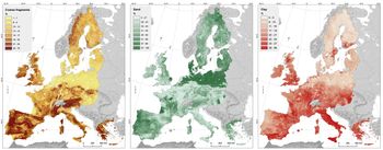
Differential access to suitable raw materials could have inhibited the adoption of hunter-gatherer pottery in Britain and Ireland. The Swifterbant, Ertebølle, Sperrings and Early Comb ware regions are characterised by cover sedimentologies with low clay/high sand content, and low frequencies of coarse fragments. In contrast, Britain and Ireland can generally be characterised by high clay/low sand soils, with variable coarse-fragment compositions (Figure 3). As such, significant differences exist between present-day sediment composition in areas of Europe where hunter-gatherers adopted ceramic technologies during the fifth millennium BC and areas where they did not. Although substantial lacunae still exist across Britain, Mesolithic site distributions based on historical research biases and archaeological visibility—which have prioritised fieldwork on more freely draining or shallow substrates—are gradually being complemented on clay geologies by the broader coverage prospection undertaken as part of development-led archaeology (Historic England in press). Clearly, sediments suitable for pottery production are widely available in both Britain and Ireland, as the later history of ceramic technologies attests. It remains possible, however, that variable patterns of Mesolithic occupation may have inhibited opportunities to encounter these sediments. If this were the case, the precise character of these patterns remains to be defined archaeologically.
Cover soil composition maps of Europe, based on LUCAS topsoil data (Tóth et al. Reference Tóth, Jones and Montanarella2013).

Proposition 9
‘Low population densities in Britain and Ireland prevented the spread of new technologies generally’
During the Late Pleistocene in Japan, pottery was produced only in very low quantities (Taniguchi Reference Taniguchi, Tsuene, Nieuwenhuyse and Campbell2017). Kaner (Reference Kaner, Jordan and Zvelebil2009) argues that this is due to the dispersal of hunter-gatherers into small and isolated groups, who lacked the ontological security required to invest in intensive ceramic production. In contrast, during the Holocene when environmental conditions favoured population expansion, pottery was produced on a much larger scale, with the emergence of regional styles. Hunter-gatherers in Britain and Ireland may have faced similar ontological inhibitors if living in dispersed, low-density populations for which the novel concepts of making and using pottery were not reinforced by ‘normative’ behaviour. Three distinct approaches to estimating population density have been applied to the Irish and British Mesolithic based on radiocarbon dates, ancient DNA (aDNA) analysis and models formed from ethnographic demography data.
Fifth-millennium cal BC Britain has relatively few robustly dated ‘site phases’ compared with later prehistoric periods in Britain. This has been interpreted as evidence for a relatively low population in Late Mesolithic Britain (Collard et al. Reference Collard, Edinborough, Shennan and Thomas2010). Analysis of the archaeological data, however, is fundamentally problematic, as the character of Neolithic behaviour is intrinsically more likely to produce recognisable, structural ‘site phases’ and associated radiocarbon dates (Blinkhorn & Milner Reference Blinkhorn and Milner2014). Environmental change and variation in human behaviour influence the quantities of dated archaeological contexts. Dates for the Late Mesolithic, for example, are contingent upon both the marked increased in palaeoenvironmental evidence for Corylus avellana (otherwise known as the ‘hazel rise’) that provided the ubiquitous charred hazel shells on which British Mesolithic chronologies rely, and stratified sequences of dateable charcoal produced by the geographically and chronologically constricted practice of stone-lined hearth construction (Griffiths Reference Griffiths2014). Neolithic dates often derive from domesticated animal bones or preserved human remains, which are, respectively, either absent or extremely rare within Late Mesolithic British contexts. Similar factors affect the archaeological record of Late Mesolithic Ireland, where, despite the widespread distribution of typologically ‘Late Mesolithic’ lithics dating to c. 6000–4000 cal BC, few sites have produced stratified radiocarbon dates. The Mesolithic is therefore disproportionately underrepresented within radiocarbon datasets, and although these studies highlight the potential for a low population in the Late Mesolithic of Britain and Ireland, it has yet to be conclusively demonstrated.
The strongest evidence for low population densities prior to the arrival of farming in Britain derives from Mesolithic, Neolithic and Bronze Age DNA (Brace et al. Reference Brace2019). Put simply, the degree of hunter-gatherer genetic ancestry within later Neolithic groups of Britain is lower than would be expected had a large hunter-gatherer population inhabited Britain during the fifth millennium cal BC—as appears to be the case in other areas of continental Europe (e.g. Olalde et al. Reference Olalde2018). The genetic evidence from Britain points towards a different scenario from that observed in southern Sweden, for example, where aDNA analysis has shown genetic continuity between ceramic-using hunter-gatherers (i.e. Ertebølle to Pitted Ware, 5500–2600 cal BC) well beyond the arrival of Neolithic populations and the introduction of farming (Skoglund et al. Reference Skoglund2014). This pattern has been interpreted as evidence for a large, resilient indigenous population that underwent cultural change during the Neolithic period. The emerging DNA evidence, however, provides only comparative insights into population sizes, rather than a direct measure. Factors other than population size, such as selection, behaviour and outward migration would also have a bearing on changes in genetic makeup over time. Furthermore, we are still far from converting observations of contrasting population dynamics to any comparable census data. Nevertheless, the genetic history of Mesolithic Britain seems atypical in the wider European context.
In contrast, attempts to predict the size of hunter-gatherer populations using ethnographic data contradict the idea that Late Mesolithic Britain and Ireland were sparsely populated. Tallavaara et al. (Reference Tallavaara, Eronen and Luoto2018), for example, model global carrying capacities for hunter-gatherer societies using a range of variables alongside ethnographic data, including mean annual climate, mammal, bird and vascular plant richness and pathogenic risks. Their model suggests that Britain and Ireland had the potential to sustain populations as dense as, if not more so, other regions of Europe where pottery was produced. Although this study lacks direct engagement with archaeological data, it demonstrates the potential of Britain and Ireland to support large hunter-gatherer populations. It is notable, however, that despite their respective limitations, the models deriving from archaeological evidence (aDNA and radiocarbon datasets) both suggest a low population density in Late Mesolithic Britain and Ireland.
Conclusion
Other than a possible difference in soil composition, the environmental and ecological conditions in Ireland and Britain appear to have been similar to the Baltic and North Sea coasts of continental Europe, where pottery was readily adopted and widely used during the fifth millennium cal BC. Social and demographic considerations must therefore be invoked to explain why Mesolithic hunter-gatherers in Britain and Ireland remained aceramic. Although capable of supporting large numbers of hunter-gatherers, the low degree of relevant ancestry recorded in the DNA of Neolithic British individuals would appear to preclude a high population density during the Late Mesolithic. This interpretation is supported by crude population assessments made by considering relative numbers of radiocarbon dates. While both of these measures have their respective limitations, it can be argued that relative population density was key to the transmission of ceramic technology.
Contact with continental Europe, as evidenced by other types of material culture, suggests that hunter-gatherers in Britain probably had knowledge of ceramic technology. Such knowledge, however, does not necessarily equate to its adoption, which requires changes in attitude and behaviour that are underpinned by concepts of relative technological merit (e.g. assessment of relative performance, risk and cost; Ajzen Reference Ajzen1991). Such concepts could include perceived barriers or incentives regarding pottery production and use (control beliefs), social pressures regarding the merits or inferiority of pottery technology (normative beliefs), or prior beliefs in the advantages and disadvantages of pottery technology (behavioural beliefs) (Ajzen Reference Ajzen1991).
Sociodemography is clearly relevant to the transmission of these concepts. As Kaner (Reference Kaner, Jordan and Zvelebil2009) notes for the Jōmon, pottery production did not normalise until the population dynamics—in terms of size and connectivity—facilitated the sharing and reinforcement of the key concepts of ceramic production and use. A similar, synchronous population density increase and shift in exchange networks is observed with the adoption of pottery at 6000–4000 cal BC in Finmark (Damm et al. Reference Damm, Skandfer, Jørgensen, Sjögren, Vollan and Jordan2019). It seems plausible that the networks connecting hunter-gatherers in Ireland and Britain to their continental neighbours did not provide the forms of contact required to facilitate the conceptual shifts necessary for the adoption of pottery. While these populations were clearly exchanging ideas, this contact was evidently not in a form that allowed for the transmission of ceramic technologies specifically. As such, the inhabitants of fifth-millennium BC Britain and Ireland lacked salient beliefs in the efficacy of pottery compared with competing technologies for preparing and storing foods and other natural products. Neolithic farmers arriving in Britain and Ireland at the start of the following millennium faced no such inhibitions: pottery had already been firmly embedded in their technological repertoire and part of their worldview for many generations.
There is an emerging body of research demonstrating contact between Britain, Ireland and continental Europe during the fifth millennium cal BC, and a well-documented widespread use of pottery by hunter-gatherers in other contemporaneous regions of Northern Europe. Thus, the question of why pottery was not adopted in Britain and Ireland becomes particularly pertinent for Mesolithic research. The process of pottery adoption is no longer a concern reserved exclusively for Neolithic archaeology in Europe.
Acknowledgements
This paper stems from an invited contribution to the Early Pottery Research Group Meeting in York in 2017, and was supported by the ERC Advanced Grant INDUCE (ERC-2015-AdG, 695539). We are grateful to the two anonymous reviewers for their support and feedback.