Introduction
Seamounts are prominent components of the seabed landscape not uniformly distributed in the ocean basins (Wessel et al., Reference Wessel, Sandwell and Kim2010). Owing to their elevation above the seabed, seamounts can deeply modify local hydrodynamic conditions, increasing the transport of particulate organic matter and sustaining a substantial level of planktonic productivity (Ramirez-Llodra et al., Reference Ramirez-Llodra, Brandt, Danovaro, De Mol, Escobar, German, Levin, Martinez Arbizu, Menot, Buhl-Mortensen, Narayanaswamy, Smith, Tittensor, Tyler, Vanreusel and Vecchione2010). These characteristics promote the settlement of highly diversified benthic communities, spatially dominated by habitat-forming species (e.g. cold-water corals), as well as the aggregation of demersal and benthopelagic fishes gathered for spawning, feeding or shelter (Pitcher et al., Reference Pitcher, Morato, Hart, Clark, Haggan and Santos2008; Clark et al., Reference Clark, Rowden, Schlacher, Williams, Consalvey, Stocks, Rogers, O'Hara, White, Shank and Hall-Spencer2010; Consalvey et al., Reference Consalvey, Clark, Rowden, Stocks and McIntyre2010; Rowden et al., Reference Rowden, Dower, Schlacher, Consalvey and Clark2010; Rogers, Reference Rogers2019). Indeed, seamounts and seamount-like structures (such as ridges, banks and mounds) have been frequently recognized as biodiversity hotspots (Pitcher et al., Reference Pitcher, Morato, Hart, Clark, Haggan and Santos2008; Consalvey et al., Reference Consalvey, Clark, Rowden, Stocks and McIntyre2010; Morato et al., Reference Morato, Pitcher, Clark, Menezes, Tempera, Porteiro, Giacomello and Santos2010; Ramirez-Llodra et al., Reference Ramirez-Llodra, Brandt, Danovaro, De Mol, Escobar, German, Levin, Martinez Arbizu, Menot, Buhl-Mortensen, Narayanaswamy, Smith, Tittensor, Tyler, Vanreusel and Vecchione2010; Kvile et al., Reference Kvile, Taranto, Pitcher and Morato2014; Würtz & Rovere, 2015; Rogers, Reference Rogers2019).
The occurrence of large aggregations of fish, including several vulnerable species of high commercial value, on the seamounts have made them very popular fishing grounds for both small and large-scale fisheries worldwide (Silva & Pinho, Reference Silva, Pinho, Pitcher, Morato, Hart, Clark, Haggan and Santos2007; Clark et al., Reference Clark, Schlacher, Rowden, Stocks and Consalvey2012; Tracey et al., Reference Tracey, Clark, Anderson and Kim2012). In recent decades, the availability of cost-effective geopositioning systems enabled professional and recreational fishermen to intensively fish on seamounts and offshore banks, with negative effects on the biological cycles of many target species. Overexploitation of fish resources and damage of the highly vulnerable habitat-building fauna caused by the use of destructive fishing gears and other developing activities, such as seabed mining and oil and gas exploitation, can be considered the most relevant environmental issues affecting seamounts (Morato et al., Reference Morato, Pitcher, Clark, Menezes, Tempera, Porteiro, Giacomello and Santos2010; Pitcher et al., Reference Pitcher, Clark, Morato and Watson2010). A large-scale analysis of litter on the seafloor across several locations in European seas indicated that derelict fishing gear (lines and nets) were the most abundant litter items on seamounts, banks, mounds and ocean ridges (Pham et al., Reference Pham, Ramirez-Llodra, Alt, Amaro, Bergmann, Canals, Company, Davies, Duineveld, Galgani, Howell, Huvenne Veerle, Isidro, Jones, Lastras, Morato, Gomes-Pereira, Purser, Stewart, Tojeira, Tubau, Van Rooij and Tyler2014).
A growing concern about the ecological relevance of seamounts and their vulnerability to several human-induced threats has led to several conservation initiatives at different geographic scales (Probert et al., Reference Probert, Christiansen, Gjerde, Gubbay, Santos, Pitcher, Morato, Hart, Clark, Haggan and Santos2007; Morato et al., Reference Morato, Pitcher, Clark, Menezes, Tempera, Porteiro, Giacomello and Santos2010). In 2006, the United Nations included seamounts in the list of vulnerable marine ecosystems (VMEs), and the United Nations General Assembly (UNGA) adopted the Resolution 61/105 on sustainable fisheries, which called upon regional fisheries management organisations to identify VMEs and to counteract the impact of destructive fishing practices also taking drastic management measures such as fishing closures (UNGA, 2007).
In recent years, the institution of new offshore marine protected areas within the Natura 2000 network (https://ec.europa.eu/environment/nature/natura2000/index_en.htm) has been strongly promoted by the member states, especially in relation to the presence of the habitat ‘1170 Reefs’ (Sanchez et al., Reference Sánchez, Basalo, García-Alegre and Gómez-Ballesteros2017). Indeed, a variety of hard bottom habitats and topographic features (e.g. seamounts, banks and ridges) fall under the definition of ‘1170 Reefs’ (EC, 2013). Despite the growing awareness of the need to protect seamounts and other deep-sea environments at a global scale, a large majority of these environments in the Mediterranean Sea are still unprotected (Oceana, 2020).
Current knowledge of the nearly 250 seamounts found in the Mediterranean basin is extremely limited, especially in terms of biological characterization (Würtz & Rovere, 2015). Some investigations carried out in recent years to explore the seamount system (the Aceste-Tiberio and Scuso Seamounts) located off the north-eastern coasts of Sicily reported the occurrence of vulnerable ecosystems largely impacted by litter and lost fishing gear (Freiwald et al., Reference Freiwald, Boetius and Bohrmann2011; Aguilar et al., Reference Aguilar, Pastor, Garcia, Marin and Ubero2013; Angiolillo et al., Reference Angiolillo, Lorenzo, Farcomeni, Bo, Bavestrello, Santangelo, Cau, Mastascusa, Cau, Sacco and Canese2015, Reference Angiolillo, La Mesa, Giusti, Salvati, Di Lorenzo, Rossi, Canese and Tunesi2021). In the Aceste Seamount, Aguilar et al. (Reference Aguilar, Pastor, Garcia, Marin and Ubero2013) recorded some valuable benthic assemblages, such as coral gardens of alcyionacea (Ellisella flagellum, Callogorgia verticillata, Paramuricea spp., Eunicella spp.), antipatharians and scleractinians, and two protected elasmobranch species (Oxynotus centrina and Leucoraja circularis). The atlas of Mediterranean seamounts by Würtz & Rovere (2015) contains the only available information on the benthic fauna of the Scuso Seamount. The faunistic data included the black coral Antipathella subpinnata, some colonies of Acanthogorgia hirsuta and Corallium rubrum, the alcyonacean Alcyonium coralloides and a few species of fish (Scorpaena sp., Anthias anthias and Zeus faber).
To gain new insights into the benthic and nectobenthic communities inhabiting the Aceste-Tiberio and Scuso Seamounts and other unexplored seamount-like structures (the Marettimo Banks) located in the same area, a research campaign was conducted in 2018 by means of remotely operated vehicle (ROV) surveys. In this paper, the data collected in these surveys concerning the demersal fish assemblages are analysed and discussed. Our specific aims are to: (i) provide a description of the demersal fish assemblages observed in the investigated area; (ii) evaluate differences in fish distribution pattern among the seamounts and banks also in relation to depth; (iii) identify among a suite of environmental descriptors those better at explaining the fish distribution pattern; (iv) quantify the presence of lost fishing gear as a proxy of fishing pressure; and finally (v) identify areas of major concern for the conservation of vulnerable species.
Materials and methods
Study area
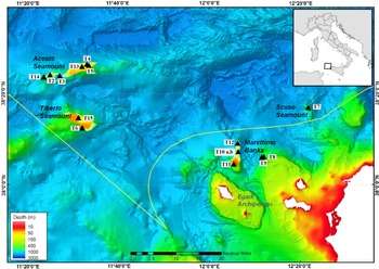
The study area is located off the north-western coasts of Sicily (Italy, western Mediterranean Sea) and includes the following seamounts and seamount-like structures, ordered from west to east: the Aceste and Tiberio Seamounts, the Marettimo Banks and the Scuso Seamount (Figure 1). The Aceste Seamount is an elongated E–W oriented structure, about 60–80 km long and 20 km wide, with a summit area at 120 m depth, located 30 nautical miles (NM) off Marettimo, the westernmost island of the Egadi Archipelago (Würtz & Rovere, 2015; Pensa et al., Reference Pensa, Pinton, Vita, Bonamico, De Benedetti and Giordano2019). The Tiberio Seamount, usually considered as a single structure with the Aceste Seamount, lies about 8 km south of the latter and rises up to about 120 m depth (Pensa et al., Reference Pensa, Pinton, Vita, Bonamico, De Benedetti and Giordano2019). The Marettimo Banks consist of a complex of N–S oriented reliefs arising from the seafloor up to about 100 m depth and located 7 NM north of Marettimo island. The northern flanks of this complex drop steeply down to 1000 m depth, whereas the southern side slopes more gently (Colantoni et al., Reference Colantoni, Ligi, Morsiani and Penitenti1993). The Scuso Seamount, more properly a shallow bank with a summit lying at 87 m depth, is located on the north-western Sicilian continental shelf 28 NM off the coast of San Vito Lo Capo promontory (Würtz & Rovere, 2015). All the investigated seamounts fall within the boundaries of the Tyrrhenian Ecological Protection Zone (EPZ), a recently established area of extraterritorial waters in which the Italian government can exercise jurisdiction to protect and preserve the marine environment (Italian GU n.293 of 17 December 2011).
Map of the study area in the southern Tyrrhenian Sea, showing the location of the investigated seamounts and banks. Black triangles indicate the position of the ROV transects at each site. The yellow line represents the Tyrrhenian Ecological Protection Zone (EPZ) boundary.

Data collection
Data on the demersal fish assemblages of the Aceste, Tiberio and Scuso Seamounts and the Marettimo Banks were collected during a research campaign carried out in July 2018 on board the RV ‘Astrea’.
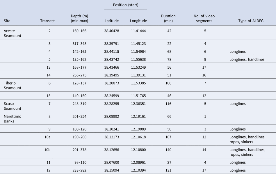
The geophysical characteristics of the seabed in the study sites were investigated using a multibeam echosounder (EM240, Kongsberg) to obtain high resolution morpho-bathymetric maps with which to identify the most interesting rocky areas to be explored with the ROV. Overall, 15 strip transects were surveyed by ROV (six transects at Aceste Seamount, two at Tiberio Seamount, one at Scuso Seamount and six at Marettimo Banks) between 98 and 378 m depth, providing 18 h 26 min of bottom footage (Table 1).
Characteristics of ROV transects carried out in the investigated seamounts and banks

ALDGF, Abandoned, lost or otherwise discarded fishing gear.
The ROV (‘Perseo’, L3 Harris) was equipped with a full HD navigation camera (1920 × 1080 pixels), located on the front of the ROV and oriented at 45° to the seafloor, and an underwater acoustic positioning system (Tracklink 1500 MA, Linquest USBL system), to gather the georeferenced position of the ROV every 1–2 s. The ROV was deployed during daylight and, on reaching the bottom, was moved along the transect at a relatively constant speed (0.3 m/s) and height above the seafloor (0.30–1.5 m). Transect length was estimated using a Geographic Information System software (ESRI ArcMAP 10.3.1), applied to the ROV track data.
Video transect analysis
Processing of video footage was performed using the VLC Media Player platform (v.3.0.11, www.videolan.org/vlc) and consisted of multiple steps. Firstly, video sections with poor quality images (i.e. out of focus, too far from the seafloor, clouded by suspended sediment) or collected in open water were removed from the analysis. Secondly, video from each transect was divided into segments, which were homogeneous in terms of type of hard substrate and thus taken as sampling units. Substrate type was classified into six categories, according to its mesoscale attributes: large rocky outcrops with high relief (LOHR), large rocky outcrops with low relief (LOLR), small rocky outcrops with high relief scattered with sand or gravel (SOHRS), small rocky outcrops with low relief scattered with sand or gravel (SOLRS), large rocky outcrops with low relief partially covered by mud (LOLRM), unconsolidated sediment (detritic sand or mud) (US). The segments of each transect were grouped according to the substrate type and their relative time length calculated, to obtain the proportion of the different substrate types at each transect.
To evaluate bottom slope, a linear regression model was obtained for each video segment by fitting a straight line to its bathymetric data points. The slopes of the regression equations of transect segments were then averaged to give the transect slope.
Finally, the video segments of each transect were grouped into two depth ranges, above and below 200 m depth (Table 1).
All sighted fishes were recorded and identified to the lowest possible taxonomic level (Fisher et al., Reference Fischer, Schneider and Bauchot1987). Digital video frames and video at reduced speed were sometimes used to help fish species identification. Fish abundance was estimated by counting single specimens or, with schools larger than 30 individuals, using abundance classes (31–50, 51–100, 101–200, 201–500, >500 individuals). The number of individuals in schools was then calculated by considering the midpoint of each abundance class (e.g. 40 individuals for the 31–50 abundance class) (Harmelin-Vivien et al., Reference Harmelin-Vivien, Harmelin, Chauvet, Duval, Galzin, Lejeune, Barnabé, Blanc, Chevalier, Duclerc and Lasserre1985). The species abundance at each transect was obtained by adding up the number of individuals observed along the transect segments.
The trophic level of each species and its membership to a specific trophic guild were assessed according to Stergiou & Karpouzi (Reference Stergiou and Karpouzi2002).
The presence of abandoned, lost or otherwise discarded fishing gear (ALDFG) (Macfadyen et al., Reference Macfadyen, Huntington and Cappell2009) was recorded, to collect indirect information on the use of the area as a fishery ground.
Data analysis
Before running the analysis, to ensure comparability among transects, abundance data were standardized by calculating the species relative abundances per transect, i.e. the percentage of total abundance (over all species) that was accounted for by each species (Clarke et al., Reference Clarke, Gorley, Somerfield and Warwick2014). Spatial distribution and species composition patterns of the fish fauna were visualized using principal coordinates (PCO) analyses on Bray–Curtis similarity matrices among transects, calculated from species relative abundance data. Vector overlays of the species showing the highest correlations with the two PCO axes (ρ1 and ρ2) (i.e.  $\sqrt {{\rm \rho }1^2 + {\rm \rho }2^2} $ > 0.45) were included in the plot, to indicate the main species driving the observed assemblage-related differences.
The BIOENV and RELATE routines in PRIMER were used to determine which environmental predictors (bottom slope and substrate type) best explain the pattern in the fish similarity matrix and to test the significance of the correlation between the environmental and fish matrices (based on Euclidean and Bray–Curtis measures, respectively) (Clarke & Gorley, Reference Clarke and Gorley2015). The strength of association between these matrices was calculated using Spearman's rank correlation. To account for differences in units, the environmental data were normalized before running the analysis.
Multivariate statistical analyses were carried out using PRIMER v6 + PERMANOVA (Plymouth Marine Laboratory, UK) (Anderson et al., Reference Anderson, Gorley and Clarke2008).
Results
The transects carried out for the Aceste Seamount were generally characterized by gently sloping rocky outcrops, frequently covered by detritic sand or mud, and colonized by structuring species such as A. hirsuta and A. subpinnata. The seafloor of the Tiberio Seamount within the investigated depth range (128–150 m) was composed of rugged rocky outcrops, with flourishing colonies of A. hirsuta, C. verticillata and A. subpinnata. Some rounded large boulders with no habitat-forming species were conversely found in the deeper margin.
For the Scuso Seamount, rocky outcrops observed along the transect showed a high level of siltation and were populated by a facies of C. verticillata and small colonies of Leiopathes glaberrima, most of which were severely damaged by lost fishing gear. The seabed of the Marettimo Banks mainly consisted of a plateau characterized by rocky outcrops interspersed with detritic bottom and scattered patches of coral rubble. In the north-western part of the banks, a forest of black corals mainly represented by L. glaberrima was the most impressive macrobenthic feature.
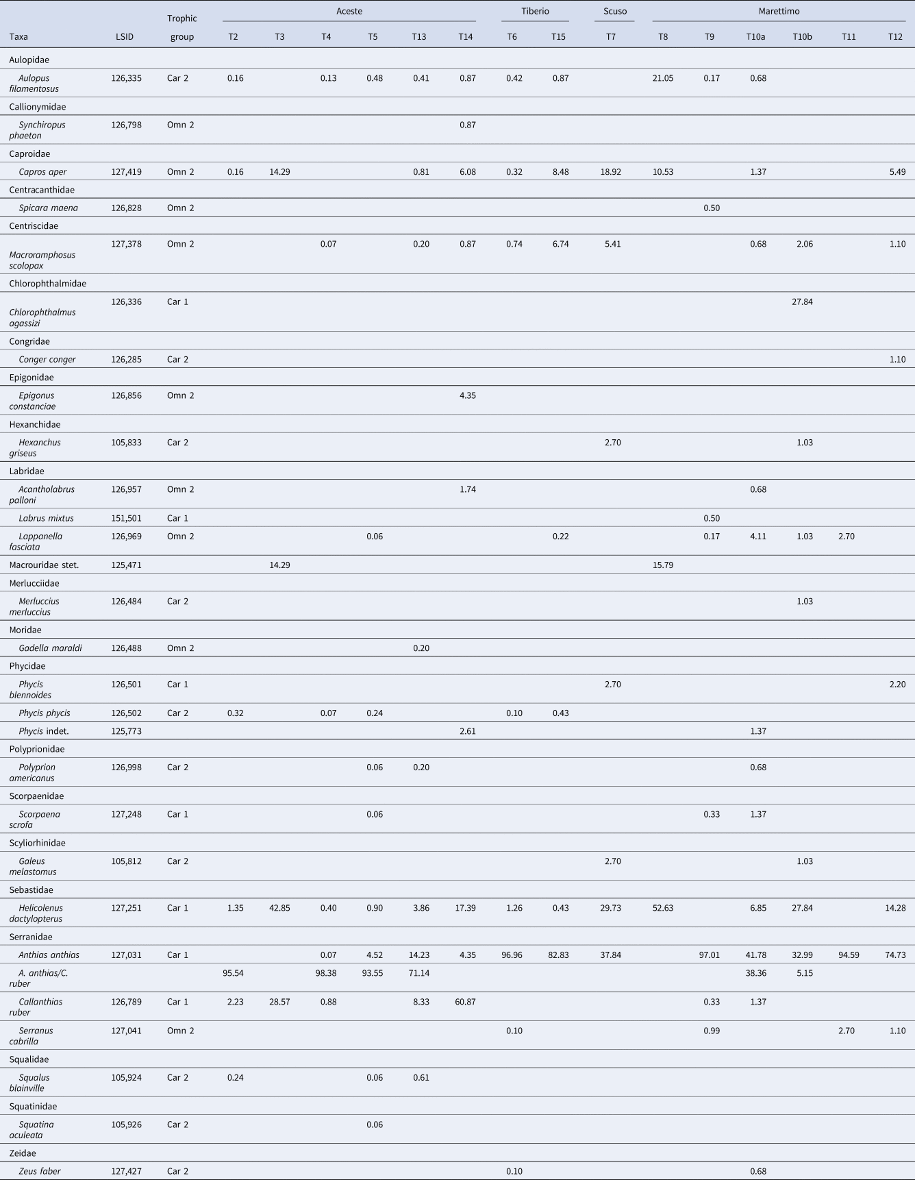
Fish assemblages recorded in the investigated area encompassed 24 taxa of teleosts (22 species, one genus – Phycis – and one family – Macrouridae) and 4 species of elasmobranchs (Table 2). The families represented by the largest number of species were Labridae and Serranidae (3 species), followed by Phycidae (2 species). Carnivores feeding preferentially on fishes and cephalopods (Carnivores 2) was the most represented trophic group (10 out of 25 species), followed by omnivores with preference for animals (Omnivores 2) (9 species) and carnivores preying upon decapods and fishes (Carnivores 1) (7 species).
Relative abundance of fish taxa recorded along the transects (T1–T15) in the investigated seamounts (Aceste, Tiberio and Scuso) and banks (Marettimo)

Trophic groups: Omn 2, Omnivores 2; Car 1, Carnivores 1; Car 2, Carnivores 2 (Stergiou & Karpouzi, Reference Stergiou and Karpouzi2002); LSID, WoRMS Life Science Identifier.
The number of species in the Marettimo Banks and the Aceste Seamount (22 and 18 species, respectively) was higher than that observed at the Tiberio and Scuso Seamounts (9 and 7 species, respectively), likely due to differences in sampling effort (i.e. number of transects). The number of species in the shallow part (above 200 m depth) of the Marettimo Banks and the Aceste Seamount was higher than in the deeper layer (>200 m depth).
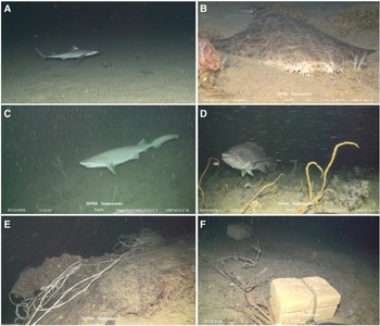
The quantitatively dominant species of the seamounts were the serranid Anthias anthias and Callanthias ruber, mainly observed in large (sometimes mixed-species) schools, and the non-gregarious sebastid Helicolenus dactylopterus, which accounted for 86% of the whole assemblage. The occurrence of some elasmobranchs of conservation concern, such as Squatina aculeata, Hexanchus griseus, Squalus blainville and Galeus melastomus was noteworthy (Figure 2).
Demersal fish species and examples of fishing litter in the investigated seamounts and banks. (A) Squalus blainville; (B) Squatina aculeata; (C) Hexanchus griseus; (D) Polyprion americanus; (E) longline entangling rocky outcrops; (F) ropes with sinkers.

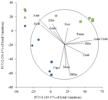
The ordination of transects provided by the PCO analysis revealed different degrees of separation in relation to seamounts and depth range. A high percentage (75.4%) of the total variation inherent in the data matrix was explained by the first two PCO axes (Figure 3). The most evident separation occurred between the shallow and deep transects of the Aceste Seamount, located in the upper right and lower left quadrants of the plot, which were also clearly segregated from those belonging to the other seamounts. The transects of Marettimo Banks, although well separated from one another according to depth range, were very scattered in the diagram and mixed with the transects located at the Tiberio and Scuso Seamounts.
A Principal Coordinates Analysis (PCO) scatter plot displaying the transects surveyed in the study sites. The PCO was based on a Bray–Curtis Similarity Matrix created using the relative abundances of fishes. Transects are labelled according to site (quadrats = Aceste Seamount; rhombus = Scuso Seamount; triangles = Tiberio Seamount; circles = Marettimo Banks) and depth range (light blue symbols = >200 m depth; green symbols = <200 m depth). Vector overlay shows the taxa mainly contributing to the observed pattern. Aant, Anthias anthias; Aant/Crub, Anthias anthias/Callanthias ruber; Crub, Callanthias ruber; Cape, Capros aper; Hdac, Helicolenus dactylopterus; Lmix, Labrus mixtus; Lfas, Lappanella fasciata; Macr, Macrouridae stet.; Pame, Polyprion americanus; Sscr, Scorpaena scrofa; Scab, Serranus cabrilla; Sbla, Squalus blainville.

Overall, 12 species were highly correlated with the PCO axes and included in the plot. Eight species plotted in the upper side of the diagram, since they were mostly or exclusively associated with the shallow transects of one (e.g. Squalus blainvillei in the Aceste Seamount) or more (e.g. Lappanella fasciata in the Aceste and Tiberio Seamonts and the Marettimo Banks) of the investigated sites. Some fish typically dwelling in deeper waters, such as Capros aper, Helicolenus dactylopterus, Callanthias ruber and macrourids, plotted conversely in the lower side of the diagram.
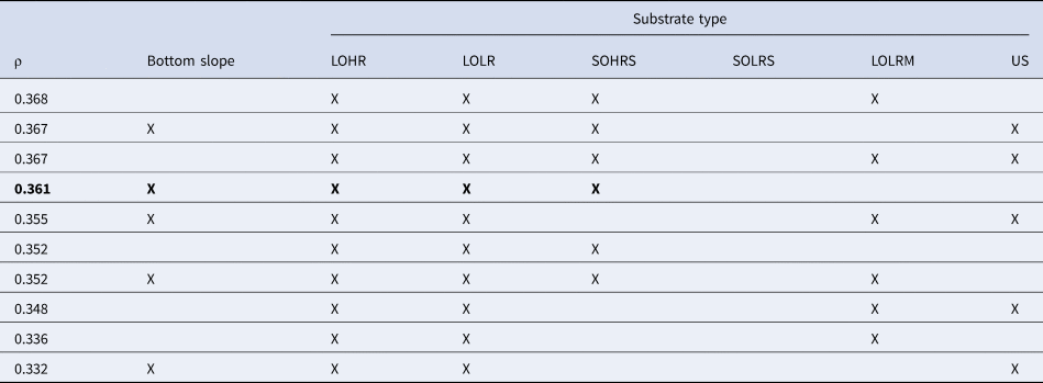
Results from the RELATE test indicated a significant relationship between the fish assemblage and the environmental predictors, with three of the 999 permutations equal to or greater than the measured correlation value (ρ = 0.329, P < 0.005). The BIOENV analysis showed that the model best explaining the similarity patterns between the two similarity matrices included bottom slope and three substrate types (LOHR, LOLR and SOHRS). Indeed, on grounds of parsimony, this model should be preferred over the best 10 models obtained (Table 3).
Results of BIOENV analysis comparing spatial variation in fish assemblage structure with seven environmental predictors (bottom slope and a suite of substrate types)

The top 10 models derived from the analysis are given. The preferred model is in bold. LOHR, large rocky outcrops with high relief; LOLR, large rocky outcrops with low relief; SOHRS, small rocky outcrops with high relief scattered with sand or gravel; SOLRS, small rocky outcrops with low relief scattered with sand or gravel; LOLRM, large rocky outcrops with low relief partially covered by mud; US, unconsolidated sediment (detritic sand or mud).
Many ALDFG (mainly longlines, handlines and ropes) and other fishing debris (e.g. concrete stones used as sinkers) were recorded along the ROV transects (Table 1, Figure 2). The Marettimo Banks were the most impacted site (four out of five transects with a massive presence of fishing gears and litter items), followed by the Scuso Seamount (one transect with several longlines) and the Aceste Seamount (two out of six transects with longlines and handlines). No ALDGF was observed along the transects of the Tiberio Seamount.
Discussion
Data collected in the present work largely improved the knowledge of the demersal fishes of the Aceste, Tiberio and Scuso Seamounts and provided the first characterization of the fish assemblage inhabiting the Marettimo Banks. Some differences in species composition emerged among the assemblages recorded in the investigated sites. Very few species, including Anthias anthias, Helicolenus dactylopterus, Macroramphosus scolopax and Capros aper were observed throughout the study area. All these fish are small-sized species, reported among the dominant taxa in other seamounts and banks (Porteiro et al., Reference Porteiro, Gomes-Pereira, Pham, Tempera and Santos2013; Consoli et al., Reference Consoli, Esposito, Battaglia, Altobelli, Perzia, Romeo, Canese and Andaloro2016).
Other species frequently found in the Mediterranean circalittoral rocky shores, such as Aulopus filamentosus and Lappanella fasciata (e.g. Porteiro et al., Reference Porteiro, Gomes-Pereira, Pham, Tempera and Santos2013, Consoli et al., Reference Consoli, Esposito, Battaglia, Altobelli, Perzia, Romeo, Canese and Andaloro2016; Consalvo et al., Reference Consalvo, La Mesa, Canese, Giusti, Salvati, Loia and Tunesi2021), were recorded at every site except the Scuso Seamount. The lower sampling effort (i.e. number of transects) and the narrower investigated depth range at the Scuso and Tiberio Seamounts could partially explain the lack of some very common fish (e.g. Callanthias ruber) and, generally, the lower number of species compared with the other sites.
All the elasmobranch species reported in our study (i.e. Squatina aculeata, Hexanchus griseus, Squalus blainville and Galeus melastomus) were very scantly recorded but their presence is noteworthy in terms of biodiversity conservation. These records, together with the findings of Aguilar et al. (Reference Aguilar, Pastor, Garcia, Marin and Ubero2013), who reported the presence of five species of sharks and rays in the Aceste Seamount, confirm the suitability and importance of these seamounts for elasmobranchs.
The presence of S. aculeata in our samples is particularly valuable, since this species is one of the most endangered elasmobranchs of the Mediterranean Sea (Gordon et al., Reference Gordon, Hood, Al Mabruk, Barker, Bartolí, Ben Abdelhamid, Bradai, Dulvy, Fortibuoni, Giovos, Jimenez Alvarado, Meyers, Morey, Niedermuller, Pauly, Serena and Vacchi2019). It is a bottom-dwelling angel shark inhabiting continental shelf and slope where it is particularly susceptible to bycatch in benthic fisheries such as bottom trawls and trammel nets (Miller, Reference Miller2016; Gordon et al., Reference Gordon, Hood, Al Mabruk, Barker, Bartolí, Ben Abdelhamid, Bradai, Dulvy, Fortibuoni, Giovos, Jimenez Alvarado, Meyers, Morey, Niedermuller, Pauly, Serena and Vacchi2019). In the last few decades, the species suffered a drastic decline and completely disappeared from many Mediterranean areas (Soldo & Bariche, Reference Soldo and Bariche2016; Gordon et al., Reference Gordon, Hood, Al Mabruk, Barker, Bartolí, Ben Abdelhamid, Bradai, Dulvy, Fortibuoni, Giovos, Jimenez Alvarado, Meyers, Morey, Niedermuller, Pauly, Serena and Vacchi2019). Squatina aculeata is included in the list of ‘endangered or threatened species’ of Annex II of the SPA/BD Protocol of the Barcelona Convention and assessed as ‘critically endangered’ in the Mediterranean IUCN Red List (Soldo & Bariche, Reference Soldo and Bariche2016). Recently, Gordon et al. (Reference Gordon, Hood, Al Mabruk, Barker, Bartolí, Ben Abdelhamid, Bradai, Dulvy, Fortibuoni, Giovos, Jimenez Alvarado, Meyers, Morey, Niedermuller, Pauly, Serena and Vacchi2019) developed the Eastern Atlantic & Mediterranean Angel Shark Conservation Strategy as a framework within which to implement effective conservation actions for the three critically endangered angel sharks found in these basins (S. aculeata, Squatina squatina and Squatina oculata).
The IUCN assessment carried out for the Italian seas classified the other three shark species in the categories of minor concern: ‘Near Threatened’ (S. blainville), ‘Least Concern’ (G. melastomus) and ‘Data Deficient’ (H. griseus) (Rondinini et al., Reference Rondinini, Battistoni, Peronace and Teofili2013). New data on the occurrence of species included in the ‘data deficient’ are useful to fill the gap of knowledge on their distribution and abundance.
Fish assemblages of the investigated seamounts and banks were numerically dominated by two zooplanktivorous fish, A. anthias and C. ruber, frequently observed in dense mixed-species shoals. A similar structural pattern was described also in other Mediterranean and Atlantic seamounts and deep-sea rocky habitats (Pakhorukov, Reference Pakhorukov2008; Christiansen et al., Reference Christiansen, Martin and Hirch2009; Porteiro et al., Reference Porteiro, Gomes-Pereira, Pham, Tempera and Santos2013; Consoli et al., Reference Consoli, Esposito, Battaglia, Altobelli, Perzia, Romeo, Canese and Andaloro2016; Consalvo et al., Reference Consalvo, La Mesa, Canese, Giusti, Salvati, Loia and Tunesi2021).
The high level of productivity usually associated with seamounts makes them very suitable habitats to sustain large aggregations of planktonic consumers. As suggested by some authors, the zooplanktivorous fish guild can play a key role in the trophic pathways of the mesophotic environments of seamounts (Hirch & Christiansen, Reference Hirch and Christiansen2010; Stefanoudis et al., Reference Stefanoudis, Gress, Pitt, Smith, Kincaid, Rivers, Andradi-Brown, Rowlands, Woodall and Rogers2019). Indeed, they actively contribute to the transfer of energy from the pelagic to the benthic environment, where they represent important prey of benthic and benthopelagic piscivorous fishes (Weaver et al., Reference Weaver, Dennis and Sulak2001; Porteiro et al., Reference Porteiro, Gomes-Pereira, Pham, Tempera and Santos2013).
In our study, the trophic guild of piscivores (Carnivores 2, according to Stergiou & Karpouzi, Reference Stergiou and Karpouzi2002) was represented by a small number of individuals (except for H. dactylopterus), despite the massive presence of their potential prey species. This finding suggested that the quantitative predator–prey relationships between piscivorous and zooplanktivorous fishes in the investigated area was strongly skewed towards the latter species. For instance, it should be noted that only three individuals of Polyprion americanus were present, an apex predator and vulnerable species for Italian waters (Relini et al., Reference Relini, Serena, Silvestri, Battistoni, Teofili and Rondinini2017). A clear example of the vulnerability of P. americanus to overexploitation is given by Bo et al. (Reference Bo, Coppari, Betti, Enrichetti, Bertolino, Massa, Bava, Gay, Cattaneo-Vietti and Bavestrello2020), who reported the drastic decline of the wreckfish population of the Ulisse and Penelope seamounts (Ligurian Sea) from at least 120 individuals in the early 1970s to the complete disappearance.
As revealed by the multivariate analysis, the fish assemblage of the Aceste Seamount, and especially that recorded in the shallow transects (above 200 m depth), differed from those of the other seamounts and the Marettimo Banks, which largely overlapped. The ordination of the sampling units (transects) in the plot was significantly influenced by depth range. Depth-related differences among sampling units were also observed in the number of species that was higher in the shallow transects than in the deep ones. The influence of depth in structuring the fish assemblages of seamounts and other deep-sea rocky environments has also been analysed in other studies (Busby et al., Reference Busby, Mier and Brodeur2005; Porteiro et al., Reference Porteiro, Gomes-Pereira, Pham, Tempera and Santos2013; Consoli et al., Reference Consoli, Esposito, Battaglia, Altobelli, Perzia, Romeo, Canese and Andaloro2016; Stefanoudis et al., Reference Stefanoudis, Gress, Pitt, Smith, Kincaid, Rivers, Andradi-Brown, Rowlands, Woodall and Rogers2019; Consalvo et al., Reference Consalvo, La Mesa, Canese, Giusti, Salvati, Loia and Tunesi2021). Our results seem to agree with the distinction between upper and lower rariphotic zones with a faunal break at about 190 m depth as proposed by Baldwin et al. (Reference Baldwin, Tornabene and Robertson2018) for the Caribbean reef fish assemblages. This boundary depth was not detected in the Bermuda Islands by Stefanoudis et al. (Reference Stefanoudis, Gress, Pitt, Smith, Kincaid, Rivers, Andradi-Brown, Rowlands, Woodall and Rogers2019), who collected evidence of a distinct and homogeneous rariphotic assemblage within 150–300 m depth range. However, we acknowledge that discrepancies between our and previous investigations may be due to other location-specific characteristics (e.g. substrate composition, habitat complexity and heterogeneity, marine biogeographic realm) and/or differences in the survey methods.
Our analysis revealed a significant effect of bottom slope and some substrate types on the fish distribution pattern in the investigated sites. The large rocky outcrops with either high or low relief (LOHR and LOLR) were the substrate categories most frequently included in the top 10 models and those concurring mostly with the correlation between fish assemblage and environmental descriptors. The effect of a more patchy habitat, such as that represented by small rocky outcrops scattered with sand or gravel, seemed to occur only in the presence of high relief (i.e. SOHRS). Height of relief and the presence of holes and crevices are the most evident topographic characteristics enhancing the complexity of rocky reefs. Several investigations pointed out the influence of some habitat features, such as substrate type, height of relief and complexity in shaping the structure of demersal fish assemblages in the north-eastern Pacific (Grove & Shull, Reference Grove and Shull2008; Pacunski et al., Reference Pacunski, Palsson and Greene2013; Smith & Lindholm, Reference Smith and Lindholm2016; Tolimieri et al., Reference Tolimieri, Clarke, Clemons, Wakefield and Powell2019), north-western Atlantic (Porteiro et al., Reference Porteiro, Gomes-Pereira, Pham, Tempera and Santos2013) and central Mediterranean Sea (Consoli et al., Reference Consoli, Esposito, Battaglia, Altobelli, Perzia, Romeo, Canese and Andaloro2016). The role of bottom slope as an explanatory factor of demersal fish distribution patterns, though poorly investigated, has been documented in the rockfish assemblages of different north-eastern Pacific localities (Grove & Shull, Reference Grove and Shull2008; Pacunski et al., Reference Pacunski, Palsson and Greene2013; Smith & Lindholm, Reference Smith and Lindholm2016).
The low records of commercially important fishes observed in all the investigated sites are likely related to overfishing effects. The absence of scientifically sound data on the use of the study area as a fishery ground does not enable us to accurately assess the actual level of fishing pressure and resource exploitation. Nevertheless, the large occurrence of ALDGF and fishing debris on the explored seabed along with the analysis of fishing effort data collected by the Automatic Identification System (AIS) (https://globalfishingwatch.org/our-map/) in the area represent unequivocal evidence of fishing activities in the area.
The occurrence of lost or discarded fishing gear as a major component of the seabed litter has been documented for many Mediterranean and Atlantic seamounts and banks (Pham et al., Reference Pham, Ramirez-Llodra, Alt, Amaro, Bergmann, Canals, Company, Davies, Duineveld, Galgani, Howell, Huvenne Veerle, Isidro, Jones, Lastras, Morato, Gomes-Pereira, Purser, Stewart, Tojeira, Tubau, Van Rooij and Tyler2014; Vieira et al., Reference Vieira, Raposo, Sobral, Gonçalves, Bell and Cunha2015; Würtz & Rovere, 2015; Bo et al., Reference Bo, Coppari, Betti, Enrichetti, Bertolino, Massa, Bava, Gay, Cattaneo-Vietti and Bavestrello2020). The most evident impact of ALDGF (particularly lines and ropes) on seabed communities is caused by the entanglement of rocky outcrops, biogenic structures and sessile benthic species (Angiolillo et al., Reference Angiolillo, Lorenzo, Farcomeni, Bo, Bavestrello, Santangelo, Cau, Mastascusa, Cau, Sacco and Canese2015, Reference Angiolillo, La Mesa, Giusti, Salvati, Di Lorenzo, Rossi, Canese and Tunesi2021; Bo et al., Reference Bo, Coppari, Betti, Enrichetti, Bertolino, Massa, Bava, Gay, Cattaneo-Vietti and Bavestrello2020). As suggested by Bo et al. (Reference Bo, Coppari, Betti, Enrichetti, Bertolino, Massa, Bava, Gay, Cattaneo-Vietti and Bavestrello2020), the chance of gear entanglement could be particularly high on rugged rocky reefs, with high relief and rich in arborescent species.
The level of exploitation of seamounts and banks as fishing grounds is likely dependent on their accessibility: more distant from the coastline and deeper sites should be subject to a lower fishing effort (Bo et al., Reference Bo, Coppari, Betti, Enrichetti, Bertolino, Massa, Bava, Gay, Cattaneo-Vietti and Bavestrello2020). Concordantly, we recorded a greater presence of lost gear (mainly bottom longlines and handlines) in the sites closest to the coast (i.e. the Marettimo Banks and the Scuso Seamount) compared with the remote ones (Aceste and Tiberio Seamounts). The knowledge of the demersal fish assemblage inhabiting the Aceste and Tiberio Seamounts, the Marettimo Banks and the Scuso Seamount provided by our study, together with the evidence of different levels of habitat degradation directly linked to fishing activities will be very useful to guide future monitoring and management plans for the restoration of these ecologically valuable ecosystems. Indeed, the presence of some vulnerable and threatened fish species in the investigated area makes it worthy of conservation initiatives, such as the institution of new Marine Protected Areas pertaining to the Natura 2000 network. In these sites, we consider the implementation of some form of protection or fishing restrictions could represent a step towards the recovery of such fish populations.