INTRODUCTION
The late Pleistocene landscape history of the northern Eurasian continent was spatially varied. During the last (Weichsel–Late Valday–Sartan) cryochron corresponding to Marine Isotope Stage (MIS) 2, the western part of the continent was covered by an extensive ice sheet advancing from Scandinavia, whereas to the east, vast areas of central and eastern Siberia stayed free of glacial ice, even during the coldest intervals. West Siberia lies close to the boundary between these two paleogeographical units, which makes the region particularly significant for paleoenvironmental reconstructions to better delineate the continental and global paleolandscape mosaic.
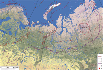
Recently, the configuration and eastern limit of the late Pleistocene continental glacier in Eurasia was grossly revised. The traditional scheme, originally presented by Saks (Reference Saks1953) and further developed by his followers (Zemtsov, Reference Zemtsov1976; Denton and Huges, Reference Denton and Hughes1981; Arkhipov, Reference Arkhipov1997), stated that the continuous ice sheet extended from northern Europe to western Siberia until the valley of the Enisey River and even further, covering northeastern Siberia (Grosswald and Hughes, Reference Grosswald and Hughes2002). Strong doubts about the possibility of the development of extensive glacier cover in West Siberia during the Pleistocene were expressed as early as the 1960s and 1970s (Kuzin, Reference Kuzin2005, Reference Kuzin2013; Krapivner, Reference Krapivner2018). Alternative scenarios have developed over the last two decades, and based on the verified distribution of glacial sediments and landforms, infer much smaller areas of ice cover for the late Pleistocene glaciation (Velichko et al., Reference Velichko, Kononov and Faustova1997; Svendsen et al., Reference Svendsen, Alexandersson, Astakhov, Demidov, Dowdeswell, Henriksen and Hjort2004; Velichko Reference Velichko2009; Sheinkman and Plyusnin, Reference Sheinkman and Plyusnin2014; Sheinkman et al., Reference Sheinkman, Melnikov, Sedov and Parnachev2017). These scenarios propose a major shift of the eastern boundary of the ice sheet. Velichko (Reference Velichko2009) draws the eastern boundary close to the Kola peninsula and the White Sea, whereas Svendsen et al. (Reference Svendsen, Alexandersson, Astakhov, Demidov, Dowdeswell, Henriksen and Hjort2004) extend the glaciated area further east, including part of the Kara Sea. In both studies, West Siberia is thought to be free of glaciers, even in its northern part. These authors, however, propose a more extensive “maximal” middle Pleistocene glaciation that advanced much farther east, occupying northern West Siberia (Fig. 1). In contrast, Sheinkman (Reference Sheinkman2016) and Sheinkman et al. (Reference Sheinkman, Melnikov, Sedov and Parnachev2017) deny the possibility of ice sheet development on the West Siberian lowland during any cold interval of the Pleistocene, based on climatological and glaciological analyses.
(color online) Limits of the Pleistocene glaciations in the northern Eurasia according to different authors and location of the studied section. Last glacial maximum (MIS 3): 1, Velichko (Reference Velichko2009); 2, Svendsen et al. (Reference Svendsen, Alexandersson, Astakhov, Demidov, Dowdeswell, Henriksen and Hjort2004); 3, Grosswald and Hughes (Reference Grosswald and Hughes2002). Maximal Pleistocene glaciation: 4, Velichko (Reference Velichko2009); 5, Svendsen et al. (Reference Svendsen, Alexandersson, Astakhov, Demidov, Dowdeswell, Henriksen and Hjort2004). Location of the studied section: 6.

In the new scenario, the northern part of the West Siberian lowland persisted free of glacial ice during the entire late Pleistocene, and even earlier (Kuzin, Reference Kuzin2013; Sheinkman, Reference Sheinkman2016, Reference Sheinkman2017; Sheinkman et al., Reference Sheinkman, Melnikov, Sedov and Parnachev2017). What kind of landscape conditions prevailed on this ice-free territory, and how did they transform in response to global climate fluctuations? The currently available paleoenvironmental reconstructions are still variable and partly contradictory. Hubberten et al. (Reference Hubberten, Andreev, Astakhov, Demidov, Dowdeswell, Henriksen and Hjort2004, p.1346) depict the late Pleistocene environmental evolution in West Siberia as follows: continental interstadial (relatively mild but still colder than present) during “the end of the Middle Weichselian” was followed by progressive cooling and spread of permafrost after 25 ka, which culminated with very cold and dry landscapes affected by eolian processes at the last glacial maximum; the late glacial was then characterized by a rise in temperature, humidity, and thermokarst processes. Velichko et al. (Reference Velichko, Timireva, Kremenetski, MacDonald and Smith2011) propose a quite different scenario for the late glacial: the spread of extra-arid cold desert ecosystems with intensive wind transport of sand. Scenarios for MIS 3 (Karginsky interstadial/thermochron) also lack consensus. Volkova (Reference Volkova2001) suggests that the climate of this period was of an interglacial type, similar or even warmer than the present and supporting forest vegetation, even in the lower Ob basin. However, Astakhov and Nazarov (Reference Astakhov and Nazarov2010) and Laukhin (Reference Laukhin2011) argue that there were cases of erroneous attribution of the older MIS 5 deposits to the Karginsky interstadial, and these led to paleoclimatic misinterpretation.
It should be stressed that the datasets behind the existing models are quite limited. In fact, geological archives for the northern part of West Siberia are still relatively scarce, and cases of their multiproxy analysis are even fewer. During the last decades, the number of study sites increased in the northernmost part of the region: the lower Ob basin and Arctic Ocean coast and shelf (Astakhov and Nazarov, Reference Astakhov and Nazarov2010; Laukhin, Reference Laukhin2011; Gusev et al. Reference Gusev, Molodkov, Streletskaya, Vasiliev, Anikina, Bondarenko and Derevyanko2016). However, more to the south, in the middle Ob basin and Siberian Uval upland, quite low site density is evident (Shpolyanskaya, Reference Shpolyanskaya2014; Streletskaya et al., Reference Streletskaya, Vasiliev, Oblogov and Tokarev2015; Sheinkman et al. Reference Sheinkman, Sedov, Shumilovskikh, Korkina, Korkin, Zinovyev and Golyeva2016).
This paper intends to provide a paleoenvironmental reconstruction of the northern part of West Siberia using multiproxy analyses from Belaya Gora, an extensive section on the left bank of the Vakh River in the middle Ob basin. The basal part of the section was earlier investigated as the key regional exposure of Tertiary sediments (Vdovin and Provodnikov, Reference Vdovin and Provodnikov1965). We focused our research on the upper parts of the section, which provide a detailed sequence of Late Quaternary sediments and paleosols with well-preserved organic materials. Some particularities of this sequence have been published recently, including data on the MIS 3 paleosol (Sedov et al., Reference Sedov, Rusakov, Sheinkman and Korkka2016), fossil insects from the MIS 5 unit (Zinoviev et al., Reference Zinovyev, Borodin, Trofimova, Sheinkman, Rusakov, Sedov and Bobkov2016), and comparison of the paleosols of Belaya Gora with eastern European analogues (Rusakov et al., Reference Rusakov, Sedov, Sheinkman, Dobrynin, Zinovyev, Trofimova, Maksimov, Kuznetsov, Korkka and Levchenko2018). Here, we present for the first time integrated sedimentological, paleopedological, and paleobotanical records, which provide new insight on the regional paleoenvironmental history and allow for possibilities for correlation on continental and global scales.
MATERIALS AND METHODS
Geographical and geological setting of the Belaya Gora section
The Belaya Gora section is an extensive exposure on the left bank of the Vakh River, one of the major right-hand tributaries of the Ob River (Fig. 1). Vakh has (roughly) sublatitudinal orientation, flowing from east to west, and reaching the Ob near the city of Nizhnevartovsk. Its valley stretches along the southern slope of the Siberian Uval—an extensive, gentle, elongated upland (average elevation is 120–150 m asl; some higher areas are above 200 m asl, whereas the highest points reach 285 m asl) north of the middle Ob and Vakh Rivers that also has an east–west orientation at latitudes of 62–63°N.
Geomorphological interpretation of the Siberian Uval varies depending on the Siberian glaciation models followed by particular authors. Those who share the hypothesis of major Pleistocene ice sheets in northwestern Siberia argue that the Siberian Uval is a glacial geoform, a major moraine ridge formed at the border of the glacier that advanced southward from the side of the Arctic Ocean (Astakhov, Reference Astakhov1976; Maloletko, Reference Maloletko2008). On the contrary, the “ice-sheet skeptics” explain the Siberian Uval with Neogene-Quaternary tectonic uplift and river erosion along major sublatitudinal faults (Kuzin, Reference Kuzin2005; Sheinkman et al., Reference Sheinkman, Melnikov, Sedov and Parnachev2017). In the Vakh River valley, a set of alluvial terraces is observed; the highest one is at an altitude of 120–140 m asl (the relative height is ~40 m) and hosts the most complete Quaternary sedimentary sequences. Its surface is discontinuous: the residual terrace “islands” are surrounded by younger lower terraces and floodplains. Similar high terraces are common in the entire middle Ob basin. Supporters of the Pleistocene glacier cover hypothesis relate their origin to the extensive ice-dammed lakes (Arkhipov, Reference Arkhipov1997), whereas their opponents explain them by fluvial deposition and tectonic processes (Sheinkman, Reference Sheinkman2016)
The Vakh basin lies in the north-center of the young complex (Tertiary-Quaternary) of the West Siberian plate. Its sedimentary mantle formed in the Triassic; in the study area, it reaches a thickness of ~3 km (Kuzin, Reference Kuzin2005). In particular, the Belaya Gora site is famous as the type locality for the Korliki Formation attributed to the Oligocene (Vdovin and Provodnikov, Reference Vdovin and Provodnikov1965). An extensive outcrop of these clayey Tertiary sediments is located at the base of the upper terrace, just a half kilometer upstream from the studied Quaternary section.
The climate of the area is relatively cold continental, with a mean annual temperature of −3.9°C, with seasonal contrast from −41°C in February to +17.2°C in June, and an annual precipitation of ~470 mm (Atlas Khanty-Mansiyskogo avtonomnogo okruga-Yugry, 2004). It is part of the subzone of the northern Taigaso and is covered by coniferous forests in drained areas and interspersed oligotrophic peatlands with Sphagnum (Kukurichkin and Neshtaev, Reference Kukurichkin, Neshtaev and Ovechkina2004). The forest stands are formed by Pinus sibirica, Pinus sylvestris, Larix sp., Picea sp., and Betula sp., typical for the Taz-Enisey forest province of West Siberia (Krylov, Reference Krylov1961).
The Vakh basin lies some 300 km south of the boundary of continuous permafrost (Vasil'chuk and Vasil'chuk, Reference Vasil'chuk and Vasil'chuk2014). Only island permafrost is found in this area, mostly associated with the peat soils (Histosols) of the peatlands, whereas forest Podzols and Stagnosols have no permafrost horizon in the profile (Vasilevskaya et al., Reference Vasilevskaya, Ivanov and Bogatirev1986).
Research methods: justification and techniques
For a better understanding of the geomorphological setting of the section, we interpreted digital multiscale satellite images using Landsat 8 data available from the U.S. Geological Survey for research purposes (https://earthexplorer.usgs.gov). Their spatial and spectrometric adaptation and geomorphological interpretation were carried out with the help of the programs of the Scanex Image Processor, developed by D. Dobrynin (http://www.scanex.ru/en/company/news/sip-v5/). Interpretation included delimiting the main landforms and tectonic features of the surrounding area.
We describe the key section (61°27'25.4"N 82°28'24.1"E) from the surface soil to the current water level of the Vakh River, focusing on the depositional features of the sedimentary strata and pedogenic properties of recent soil and paleosols (designation of diagnostic horizons was performed according to the Food and Agriculture Association [2006] guidelines). Specific sampling schemes were designed for each type of analysis, which we grouped into two major blocks.
Block I included the investigations on the provenance of the sediment components as well as the deposition agents and mechanisms. Magnetic susceptibility was measured in all distinct layers and soil genetic horizons throughout the section. Clay mineral composition was studied in the layers enriched in fine material (total of 15 samples) and compared with the clay mineralogy of the Tertiary deposits from the outcrop 1 km upstream. Clay fraction was separated by gravity sedimentation in water. X-ray diffraction patterns were obtained from the oriented specimens subjected to the following pretreatments: air-dried, glycerol-saturated, and heated to 550°C.
The origin and provenance of stones in the sediments of the region have long been debated in the context of glaciation models. We selected three typical pebbles (originating from layer 10) for preparing thin sections and studying them under an Olympus BX51P petrographic microscope to detect their structure and composition and further infer their provenance.
In order to identify deposition mechanisms, we studied morphoscopy (surface texture and roundness) of the quartz sand grains sized between 0.5 and 1.0 mm under a binocular optic microscope and Scanning Electron Microscope (SEM) JEOL JSM-6610LV in the Collective Use Center at the Laboratory of Radiocarbon Dating & Electronic Microscopy of the Institute of Geography, Russian Academy of Sciences. The samples for this study were collected from five sand layers from different parts of the studied section. We performed quantitative analysis of quartz sand grain morphoscopy following the method developed and described in detail by Velichko and Timireva (Reference Velichko and Timireva1995). The essence of the method consists in the evaluation of two key coefficients: the roundness of quartz grains was estimated using the five-grade scale of Khabakov (Reference Khabakov1946) and patterns of Rukhin (Reference Rukhin1969). A roundness coefficient (Q) was then calculated, following the Russel and Taylor (Reference Russell and Taylor1937) equation:

where n0, n1, n2, n3, n4 are grain numbers of 0 to 4th classes of roundness.
The grain surface type and degree of the surface dullness (Cm) (glossy to matte) was estimated using the modified method of T.A. Salova (Kuzmina et al., Reference Kuzmina, Salova, Sudakova and Feldman1969) and calculated as follows:

where G is the number of glossy grains; QM, HM, and M are grains with quarter-matted, half-matted, and matted surfaces, respectively.
In general, the particles with glossy surfaces are associated with fluvial sedimentary environments, whereas those with matted surfaces underwent eolian transportation (Velichko and Timireva, Reference Velichko and Timireva1995). We also took into account designation of the surface features and their association with sedimentary environments by Krinsley and Doornkamp (Reference Krinsley and Doornkamp1973).
Block II consisted of investigations to provide paleoecological indicators. We relied on the pedogenetic properties of paleosols and on the palynological spectra as the main paleoenvironment proxies.
Micromorphology is considered to be one of the most efficient methods for paleosol analysis because it allows detection of the incipient features of soil-forming processes and discriminates them from postburial diagenetic effects. We collected undisturbed blocks from all paleosol genetic horizons and after impregnating them with the Cristal resin prepared thin sections. Micromorphological observations were performed under an Olympus BX51P petrographic microscope, following guidelines in Stoops (Reference Stoops2003).
In total, 20 samples for pollen analysis were collected from paleosols as well as from the loamy and clayey sediments. We suggest that the latter were deposited by low-energy agents, thus providing better conditions for pollen preservation. For pollen analysis, 2 cm3 of the sediment from each sample were treated by cold HCl (37%), cold HF (60%) for one night, acetolysis, and sieved with a mesh with diameter sizes of 200 and 10 μm. The remaining pellet was stored in glycerin and studied under 400× or 1000× magnification. One tablet of Lycopodium spores (Batch No. 1031 or 177745) was added as an exotic marker for determination of pollen concentration. Counts of at least 300 pollen grains of terrestrial plants per sample, excluding water plants and reworked and indeterminate pollen, were used to calculate percentages. Pollen concentration in samples from several depths (865, 1560, 1711 cm) was very low, resulting in lower pollen sums, while samples from depths 270–435 cm did not contain pollen. Pollen taxonomy followed Beug (Reference Beug2004). In addition to pollen, nonpollen palynomorphs (NPP) were counted (Van Geel, Reference Van Geel1978; Shumilovskikh et al., Reference Shumilovskikh, Schlütz, Achterberg, Bauerochse and Leuschner2015). Their percentages were calculated based on the pollen sum. A palynological diagram was constructed using C2 software (Juggins, Reference Juggins2007).
The chronology of the section is based on two previously published radiocarbon dates (Rusakov et al., Reference Rusakov, Sedov, Sheinkman, Dobrynin, Zinovyev, Trofimova, Maksimov, Kuznetsov, Korkka and Levchenko2018) and a new U/Th date from the peat horizon of the lower paleosol. 230Th/U dating of organic-rich sediments was performed in the Köppen Laboratory at St. Petersburg State University, Russia. We applied a modern version of an isochronous approach, which is based on agreement of isochronously corrected ages obtained for a set of the same coeval samples analyzed using two techniques: (1) acidic extraction of the sample, or leachate-alone technique (L/L model), and (2) total sample dissolution technique (TSD model) (Maksimov and Kuznetsov, Reference Maksimov and Kuznetsov2010). This method is suitable for dating organic-rich materials like peat and gyttja and was recently successfully applied to buried soils (Maksimov et al., Reference Maksimov, Zaretskaya, Shebotinov, Kuznetsov, Uspenskaya, Grigoriev and Kuksa2015). The U/Th dates from buried soils have allowed a reconsideration of the chronologies of several West Siberian Quaternary key sections, especially attribution of the organic paleosol/peat horizons (Laukhin Reference Laukhin, Arslanov, Maksimov, Kuznetsov, Shilova, Velichkevich, Chernov and Nikonorov2008a, Reference Laukhin, Maksimov, Arslanov, Kuznetsov, Chernov, Shilova and Velichkevichb) and their correlation with eastern European analogues (Maksimov et al., Reference Maksimov, Arslanov, Kuznetsov, Chernov and Frechen2006).
Based on the age estimates, stratigraphic position, and morphological and laboratory results, the main stratigraphic units (both paleopedological and sedimentary) were denominated according to the conventional nomenclature of the West Siberian Quaternary stratigraphic scheme (, Sibirskiy Nauchno-Issledovatelskiy Institut Geologii, Geofiziki i Mineralnogo Syr'ya, 2000) and correlated to MIS (Lisiecki and Raymo, Reference Lisiecki and Raymo2005).
RESULTS
Geomorphological setting and tectonic features of the Belaya Gora area
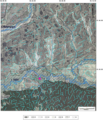
The area of the Vakh basin that hosts the Belaya Gora section has a clearly differentiated geomorphological and tectonic structure (Fig. 2). The northern part on the right bank of the river consists of extensive alluvial landforms (subdivided into three types according to their drainage status), which we associate with the recent and paleostreams flowing predominantly from the northeast to the southwest. In the south, on the left side of the Vakh River, a clear alluvial terrace sequence is observed. This major territory is occupied by the highest and oldest Vakh terrace, which has a relative elevation of 30–40 m and is subdivided into two levels. Middle and lower terraces and the floodplain are much lower, occupy smaller areas, and are closely related to the current riverbeds of Vakh and its tributaries.
Detailed geomorphological interpretation map of the Vakh River valley and the Belaya Gora area. High alluvial terrace of the Vakh River (1, 2): 1, more drained areas, swampy sites are restricted to the erosional depressions; 2, less drained part, swamps are spread on the main flat land surface; 3, swampy interfluves on the right bank of the Vakh River; 4, swampy gentle slope on the right bank of the Vakh River; 5, elongated north–south oriented fluvial plains; 6, middle alluvial terrace of the Vakh River; 7, low alluvial terrace of the Vakh River (poorly drained, swampy); 8, floodplain of the Vakh River and its tributaries. Blue lines = main tectonic lineaments. (For interpretation of the references to color in this figure legend, the reader is referred to the web version of this article.)

Orientation of the tectonic lineaments differs substantially in the northern (right bank) and southern (left bank) parts of the study area. Whereas in the south, the directions of the lineal features are irregularly scattered, the northern area shows a clear preferred northeast–southwest orientation. We suggest that the latter controlled water flow and sediment transport, especially in the right bank area, in the recent geological period.
The proposed interpretation refines the geomorphic position of the studied profile. Although the current stream of the river flows predominantly through the floodplain or the lower terraces, it touches the body of the high terrace in a few places because of intensive lateral erosion. Belaya Gora is one of these places and provides an extensive exposure of the ancient (the Pleistocene and Tertiary in the base of the section) sedimentary sequence.
Section stratigraphy and sediment characteristics
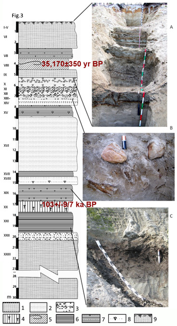
The base of the profile (starting a few meters above the present river level) is formed by a thick uniform bed of very pale, well-sorted fine to medium sand with parallel to crossed lamination (layer XXIII). The uppermost part is coarser and contains rusty seams (layer XXII). It is overlain by a package of loamy to clayey sediments (layers XX–XXI) along the sharp, undulating boundary with pockets and tongues. A set of pedogenic horizons forming the lower buried pedocomplex is developed in these loamy sediments (Fig. 3).
(color online) Stratigraphic scheme of the section with the layer numbers; photos of the selected units. A, recent surface soil and upper paleosol unit; B, rounded boulders incorporated into alluvial sediments; C, lower paleosol unit. 1, medium to fine laminated sand; 2, fine sorted sand with horizontal lamination; 3, sand with pebbles and boulders; 4, humified loam with plant detritus and peat seam (lower paleosol, ACr horizon); 5, aggregated loam with deformed humus bed (upper paleosol, Bg@ horizon); 6, clay; 7, clay interbedded with sand; 8, ferruginous mottles and seams; 9, recent surface soil (Podzol). I–XXIII = layer numbers.

The lower pedocomplex is buried by a thick set of alternating layers of clay, loam, and fine sand (layers XV–XIX). Thin horizontal lamination is observed in the major part of this unit. The overlying sediments are much coarser and consist predominantly of sand, from fine to coarse (layers IX–XIV). A characteristic feature of these strata is the presence (unique in the whole section) of stony material, which includes gravel, pebbles, and even small round boulders. It is remarkable that these boulders, derived predominantly from dark-colored rocks, are immersed in the very well-sorted pale sandy matrix. When the stones are released from their host layer and roll down the slope to the bottom of the section, they locally form stone piles imitating glacial-like deposits.
On the top of the gravelly sands lies loamy layer VIII, in which the upper synsedimentary paleosol is developed. Above it, layer VII, is also clay-loamy, but it does not display any signs of pedogenesis and conserves its sedimentary structure: every 20 cm it is intersected by thin (3 cm) but continuous sandy seams that separate four individual clayey horizons in layer VII. The uppermost sedimentary unit of the section (layers I–VI) is composed of medium sands with well-developed horizontal lamination. It provides parent material for the recent surface soil.
Macro- and micromorphology and dating of buried paleosols and surface soil
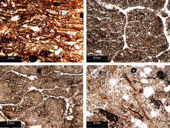
The lower paleosol unit/pedocomplex developed in layers XX and XXI (16.7–19.7 m) could be subdivided into two paleosol members. The inferior member consists of the following horizons: a thin black peat topsoil Ha containing relatively fresh wood fragments, a gray-blue humus ACr horizon (middle and lower part of layer XX), and a blueish structureless gleyed Cr horizon (layer XXI) at the bottom. The superior member (the uppermost part of layer XX) is presented by a thin (15 cm) mottled redoximorphic Bg@ horizon with clear cryogenic involution features. Micromorphology of the Ha horizon is defined by abundant, moderately decomposed plant tissue fragments with parallel orientations (Fig. 4a). A few plant fragments are also observed in the underlying ACr horizon, being mixed with the mineral material. The strongly gleyed Cr horizon unexpectedly contains illuvial coatings with quite strong interference colors; these pedofeatures are, however, deformed and partly incorporated into the mineral groundmass (Fig. 4b). The wood fragment from the Ha horizon (depth 17.1 m) produced infinite radiocarbon dates: >40 14C ka BP (SOAN-7551, SOAN-7552) and >43.5 14C ka BP (Beta 410188). The 230Th/U dating (TSD model) of the same organic horizon produced the age 103 ± 9/7 ka BP (LUU 1298TSD).
(color online) Micromorphology of the paleosols of the Belaya Gora section; plain polarized light. Lower paleosol unit: a, parallel oriented plant tissue fragments, Ha horizon; b, right side clay coating, deformed and incorporated into the groundmass, Cr horizon. Upper paleosol unit: c, compact blocky and lenticular aggregates, Bg@ horizon; d, irregularly oriented plant fragments incorporated into the groundmass, Bg@ horizon, dark seam.

The upper pedocomplex corresponds to layer VIII (3.5–4.5 m). It is formed by a light gray with small brown mottles loamy Bg@ horizon. In the middle of the horizon, a thin discontinuous dark humus seam presents a loop-shaped deformation. The material of the upper pedocomplex has a well-developed structure of subangular granules and small blocks, produced by a dense net of thin fissures. Under the microscope, a well-developed microstructure of subrounded blocks, granules, and lenticular peds was observed in the Bg@ horizon (Fig. 4c). Strong iron staining (ferruginous hypocoatings) is frequently found at the periphery of the aggregates. The dark seam in the middle of the Bg@ horizon is characterized by a heterogeneous composition of the groundmass: partly decomposed plant fragments of variable orientation are immersed in the clay-silty mineral material (Fig. 4d). Organic matter of this seam produced a calibrated radiocarbon date of 35,170 ± 350 cal yr BP (Beta-410187).
The recent surface soil on the top of the sequence has a clearly expressed profile differentiation of a Podzol type. Under a thin, partly burned litter (layer I) lies a strongly bleached, loose eluvial E horizon (layer II) with a tortuous, tonguing lower boundary. Below, a discontinuous dark brown (coffee) spodic Bhf horizon (layer III) follows the shape of that boundary, becoming thicker under the eluvial tongues. Together with a yellow-brown Bf horizon (layer VI), they comprise the illuvial part of the recent soil profile. Radiocarbon dating of humus from the Bhf horizon yielded a calibrated age of just 620–610 and 555–510 cal yr BP (Beta-410186).
Distribution of magnetic susceptibility and clay minerals
Magnetic susceptibility shows relatively low values along the whole section, and in most horizons, the values vary between 8 and 21 x 10-5 SI. Neither paleosols nor recent surface soil display strong maxima (like pedogenic enhancement usual for the loess-paleosol sequences). On the contrary, the values in the paleosol horizons were similar or sometimes even lower (as in inferior paleosol in layer XX, down to 7 x 10⁻⁵ SI) compared to that in the adjacent sedimentary layers. The highest susceptibility values were observed in the sandy sediments containing stony material (layers XII and XIII, with 8.1 and 5.4 x 10⁻⁴ SI, respectively). We associate this maximum with a higher quantity of detritic sand-size magnetic minerals present in the heavy fraction.
Clay mineral assemblages are quite uniform in all studied loamy layers, both sedimentary and those affected by paleopedogenesis. They are a three-component combination of (1) smectite and intergrades with an abundant smectite component (maximum at ~1.4 nm, shifting to smaller angles at glicolation and shrinking to 1 nm on heating); (2) illite (peak at 1 nm, not changing over pretreatments); and (3) kaolinite (peak at 0.7 nm, disappearing after heating at 550°). The relative intensities of the diffraction peaks allow for a semiquantitative estimation of the contents of these main components. Smectite is the most abundant in the majority of samples, comprising more than half of the clay material; the rest is shared between kaolinite (more common) and illite (Fig. 5a).
X-ray diffraction patterns of clay fractions from the Belaya Gora section: a, layer VII; b, Neogene sediments (red = untreated, blue = heated at 550°, green = saturated with glycerol). (For interpretation of the references to color in this figure legend, the reader is referred to the web version of this article.)

The samples from the Tertiary deposits that underlie the Quaternary sequence contain a quite different association of clay minerals. The predominant component is kaolinite, accompanied by minor quantities of illite and only traces of smectite and chlorite (Fig. 5b).
Petrographic characteristics of stone material
Up to 90% of all gravels, pebbles, and small boulders encountered in layers IX–XIV are presented by dark-colored heavy fragments of basic igneous rocks. Three thin sections from the representative fragments from layer X produced the petrographic characteristics noted below.
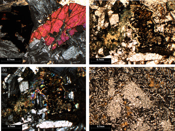
Sample 1 has a composition and structure typical of dolerite: the main components are intermediate plagioclase and monoclinic pyroxene with admixtures of opaque ore mineral. Plagioclase grains display an euhedral shape of elongated tabular crystals, whereas pyroxenes have an anhedral irregular shape occupying free spaces among plagioclase crystals (Fig. 6a).
(color online) Petrography of the stone fragments from alluvium (layers IX–XIV): a, dolerite with euhedral plagioclase and anhedral pyroxene and opaque ore mineral, N+; b, altered dolerite, pyroxene is substituted with clay minerals, PPL; c, same as b, N+; d, poikilophytic basalt, PPL. N+ = crossed polarizers, PPL = plain polarized light.

Sample 2 has a composition quite similar to that of Sample 1, but both main magmatic minerals are strongly altered. Plagioclase grains contain numerous small elongated inclusions with strong interference colors identified as sericite (fine-grained muscovite). Pyroxenes demonstrate an even higher degree of alteration: more than 50% of this component is substituted by green-brown aggregates of platy grains with high birefringence, defined as bowlingite and iddingsite (Fe-smectite, according to Delvigne et al. [Reference Delvigne, Bisdom, Sleeman and Stoops1979]) (Fig. 6b and c). We consider these alteration phenomena to be the result of postmagmatic hydrothermal processes and identify the rock as altered dolerite.
The structure of Sample 3 is quite different from the other samples. Numerous small elongated plagioclase crystals are immersed in the microcrystalline groundmass; locally, these crystals form large rounded clusters (Fig. 6d). A few Fe-Mn minerals are substituted with brown iddingsite. The rock was identified as poikilophytic basalt.
Morphoscopy of quartz sand grains
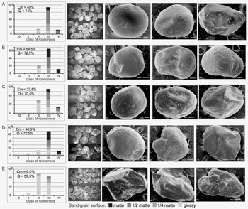
In the sample from basal layer XXIII (22.4 m), glossy grains are most abundant; only minor proportions of quarter- and half-matte grains are present, providing the surface dullness Cm of just 6%. The majority of the quartz sand particles are subrounded to rounded, so that the roundness coefficient Q reaches 59.5%. Frequent curved and V-shaped grooves together with triangular pits are observed on the surface, which in general has moderate relief; these features are typical of fluvial sedimentary environments (Fig. 7E).
Results of the morphoscopic study of the quartz grains under binocular and SEM; quantitative parameters: A, layer VI; B, layer X; C, layer XIII; D, layer XXII; E, layer XXIII. Cm = degree of the surface dullness, Q = roundness.

The sample from the overlying layer XXII (20 m) shows quite different quartz morphologies. The proportion of matte grains grows significantly, so that the surface dullness coefficient Cm reaches 46.5%. However, a significant part of the sand particles—up to 18%—have a glossy surface. The roundness coefficient Q increases to 72.5% (Fig. 7D). The surfaces have moderate smooth relief and are covered with numerous small pits both on the cambers and in the depressions on the surface; these morphostructures are usually generated by eolian processes.
The dullness coefficient Сm of the sample collected from layer XIII (7 m) is relatively low, at 27.5%. At the same time, the roundness coefficient Q is quite high, at 70.5%; many grains belong to the medium-roundness class (Fig. 7C). Surfaces with curved and V-shaped grooves and triangular pits of fluvial origin are most common, but sometimes small breakage features are present. The latter could be related to cryogenic fragmentation (Rogov, Reference Rogov2000).
Quartz sand grains from layer X (5.9 m) show the highest dullness coefficient of 54.5%. This sample has a significant proportion of particles (34%) with a completely matted surface. Most grains have a rounded smooth outline, and the roundness coefficient Q reaches 72.5% (Fig. 7B). Under SEM, we frequently observed surfaces with abundant, uniformly distributed small pits typical of eolian deposition. A few grains demonstrate typical fluvial surface morphostructures or evidence of cryogenic breakdown.
In the uppermost sample from layer VI, the number of grains with a matted surface is lower, so that the dullness coefficient Cm decreases to 40%. At the same time, the majority of grains are well rounded (most abundant are those belonging to the third class of roundness), thus the roundness coefficient Q is as high as 72.5% (Fig. 7A). The SEM surface morphologies are variable: grains with strongly pitted surfaces of eolian origin are present; however, many grains also demonstrate larger grooves typical of a fluvial environment or cryogenic breakage features.
Palynological investigations
Based on the changes in dominant and indicative taxa of pollen assemblages, the pollen diagram from the Belaya Gora section (Fig. 8) was divided into five local pollen zones abbreviated as BG (Belaya Gora).
(color online) Palynological diagram of the Belaya Gora section: a, Arboreal Pollen (AP) and Non-Arboreal Pollen (NAP); b, pollen of water plants, reworked palynomorphs, plant spores as well as algal, animal and fungal NPP.

BG-1, from layer XXI, is a Cr paleosol horizon (1870 cm) and consists of only one sample. The pollen spectra are characterized by the dominance of nonarboreal pollen (NAP), with Cyperaceae (58%), Poaceae (18%), and Artemisia (4%) accompanied by Chenopodiaceae/Amaranthaceae, Ranunculaceae, Thalictrum, Caryophyllaceae, and Polygonaceae. Arboreal pollen (AP) is dominated by Betula nana-type (3%), Salix (2%), and Betula (2%), with a few Alnus, Pinus diploxylon-type, Pinus haploxylon-type, and Pinus pumila. Spores are represented by Sphagnum (2%), Equisetum (1%), Polypodiaceae (1%), and Diphasium (<1%).
BG-2 consists of four samples collected from the middle and lower parts of layer XX, a ACr paleosol horizon (1710–1770 cm). The zone differs from BG-1 in its relatively high amount of AP (up to 60%), with a dominance of Picea (9–48%) and Betula (3–11%) accompanied by several conifer taxa such as Abies, Larix, and Pinus, and shrubs such as Betula nana-type, Alnus viridis-type, and Salix. The NAP (38–68%) is similar to the previous zone and is represented by Cyperaceae (18–47%), Poaceae (2–17%), Artemisia (2–7%), and a variety of other herbs such as Chenopodiaceae/Amaranthaceae, Ranunculaceae, Thalictrum, Caryophyllaceae, Apiaceae, Fabaceae, Primulaceae (Lysimachia vulgaris-type), Saxifragaceae, Rubiaceae, Rosaceae, and Brassicaceae (<1%). A few pollen from water plants like Typha latifolia-type, Sparganium-type, and Potamogeton occur in the zone, accompanied by algae like Botryococcus, HdV 128, Mougeotia, and oocytes of Rhabdocoela. Spores are represented by Sphagnum (1–4%), Polypodiaceae (1–12%), and Equisetum (2%), with the rare Hepaticae and Lycopodium annotinum-type. A variety of fungal spores, including facultative coprophilous fungi (Arnium, Coniochaeta, Delitschia, Podospora inflatula-type, and Gelasinospora), were documented in the zone. Local presence of spruce at a depth of 1770 cm was confirmed by the presence of Picea stomata.
The pollen spectra in the next zone, BG-3 from layer XIX (1560–1630 cm), comprising two samples, are dominated by Poaceae (26%) and Artemisia (15%), with Cyperaceae, Chenopodiaceae/Amaranthaceae, Asteraceae, and Ranunculaceae. Arboreal pollen are represented by Betula nana-type (24–33%) and Betula (10–21%), with Alnus viridis-type, Salix, and Pinus diploxylon-type. Reworked pollen from Juglans and Corylus occur in this zone. The spore assemblage is similar to that in the previous zones. The exception is the increased percentage of Sphagnum spores from a depth of 1560 cm. Pollen concentration decreased to 2–63,000 pollen grains/cm3.
In zone BG-4, consisting of four samples from layers XV and XVII (820–1410 cm), the amount of AP increases again, up to 63%, due to high values of Pinus diploxylon-type (4–10%), Pinus haploxylon-type (1–7%), Picea (1–12%), Betula (8–32%), Betula nana-type (7–13%), Alnus (2–9%), Alnus viridis-type (2–22%), and Salix (2–6%) as well as the occasional presence of Pinus pumila, Abies, Larix, and Ericales. The NAP is similar to the previous zone and is represented by Poaceae (10–22%), Artemisia (7–15%), Cyperaceae (1–12%), Ranunculaceae (1–5%), together with the less frequent taxa of Chenopodiaceae/Amaranthaceae, Asteraceae, Caryophyllaceae, Rubiaceae, Polypodiaceae, Rosaceae, Liliaceae, Campanulaceae (Phyteuma-type), Plantago major-media type, Violaceae, and Brassicaceae (<1%). Water plants are represented by Sparganium-type, Potamogeton, and Lemna, and are accompanied by algal remains of Botryococcus, Mougeotia, and HdV 128. Sporophytes are represented by Polypodiaceae, Sphagnum, Equisetum, and Diphasium. The zone also contains a great variety of reworked pollen from the Tertiary or early Pleistocene sediments, including Juglans, Ulmus, Carya, Quercus, Corylus, Ilex, Tilia, Carpinus betulus, Cupressaceae, Fagus, Liquidambar, Pterocarya, and Tsuga.
Layers VII and VIII (270–435 cm) have a very low pollen concentration or are empty of pollen.
The uppermost sample from layer I (4 cm) represents the recent pollen spectra of the surrounding area (zone BG-5). It is characterized by an absolute dominance of AP (97%), with Pinus diploxylon-type (49%), Betula (33%), Pinus haploxylon-type (14%), and few Picea and Betula nana-type. Only Artemisia and Rosaceae represent the NAP spectra. The spore assemblage is dominated by Sphagnum (60%), with a few Polypodiaceae and peat indicators such as eggs of tardigrade Macrobiotus and testate amoebae.
DISCUSSION
Section chronostratigraphy and correlation
The key strata of the studied section that enabled correlation with other regional sections as well as its integration in global climate records are the two paleopedological units. Both contain abundant organic materials, are radiometrically dated (14C for the upper unit, U/Th for the lower one, which also has a set of infinite 14C dates), and produced palynological (this paper) and macrorest (Rusakov et al., Reference Rusakov, Sedov, Sheinkman, Dobrynin, Zinovyev, Trofimova, Maksimov, Kuznetsov, Korkka and Levchenko2018) records useful for correlations.
The available 14C date supports an attribution of the upper pedocomplex (layer VIII) to the second half of MIS 3 (Sedov et al., Reference Sedov, Rusakov, Sheinkman and Korkka2016; Sheinkman et al., Reference Sheinkman, Sedov, Shumilovskikh, Korkina, Korkin, Zinovyev and Golyeva2016). This period corresponds to the Karginsky interstadial/thermochron in the West Siberian stratigraphic scheme.
The chronological framework of the lower pedocomplex (layers XX–XXI) relies on the new U/Th date from a thin peat Ha horizon; the obtained age corresponds to the substages MIS 5d/MIS 5c limit. However, this thick multiphase pedocomplex was likely formed over a longer time span. We suggest that pedogenesis of the inferior member (below the dated peat) with well-developed ACr and Cr horizons corresponds to MIS 5e, the Kazantsevo interglacial/thermochron. On the other hand, the strata above the dated peat, the uppermost Bg@ horizon and probably overlying loamy sediments of layers XV–XIX, could be attributed to the latest substages MIS 5a/MIS 5d (lower Zyryanka). This attribution agrees with the palynological data, as discussed below.
It should be stressed that in many Eurasian pedosedimentary sequences, the entire MIS 5 is represented by a pedocomplex in which the members corresponding to different substages are not clearly separated from one another in a welded soil profile. Such examples provide the proximal loess-paleosol sequences: the Berdsk pedocomplex in the southern West Siberia (Zykina and Zykin, Reference Zykina and Zykin2012) and the Mezin pedocomplex in the eastern European plain (Velichko, Reference Velichko1990). Our chronostratigraphic attribution of the paleosol units in Belaya Gora has analogues in other Late Quaternary sections of the middle Ob basin. As described above, the studied section belongs to a high alluvial terrace, usually denominated as the third, or Yermakovo/lower Zyryanka, terrace (Arkhipov, Reference Arkhipov1997). This terrace level is extensively developed in the middle Ob basin and has been studied in numerous exposures. Two major levels of paleosols—peat and organic-rich sediments—found in these exposures have been attributed to the Karginsky thermochron (now associated with MIS 3) since early work in the 1960s and 1970s (Volkova et al., Reference Volkova, Arkhipov, Babushkin, Kul'kova, Gus'kov, Kuz'mina, Levchuk, Mikhailova and Sukhorukova2003). However, further development of radiocarbon-dating methods and especially the application of U/Th dating have led to a revision of the age estimation for these levels. Whereas the upper paleosol/peat has been reliably attributed to the Karginsky (MIS 3) interval, the lower unit is considered to be much older and related to MIS 5, the Kazantsevo thermochrone and early Zyryanian interstadial (Maksimov et al., Reference Maksimov, Arslanov, Kuznetsov, Chernov and Frechen2006).
In particular, comparison between the Belaya Gora and Kiryas sections clearly demonstrates the interrelation between the marker horizons. The Kiryas exposure is located on the left bank of the Ob River, some 50 km downstream from the city of Nizhnevartovsk (~400 km west-southwest of the Belaya Gora section). The height of the terrace escarpment in Kiryas is 25 m above the river level, which is only a little less than at Belaya Gora. Kiryas has been presented as a type location of the Karginsky thermochron deposits since the 1960s, based on a number of conventional radiocarbon dates (Arkhipov, Reference Arkhipov1997). Recent redating confirmed the age estimation for the upper organic unit: the earlier (27.5–36.3 cal ka BP) and newly established (27.8–46.3 cal ka BP) dates belong to the Karginsky or middle Zyryanian thermochron/megainterstadial (MIS 3) (Laukhin et al., Reference Laukhin, Maksimov, Arslanov, Kuznetsov, Chernov, Shilova and Velichkevich2008b). However, major differences appeared during a reexamination of the lower peat horizon at the basal part of the section. While the radiocarbon ages obtained earlier fell within the range of 38.7–44.7 ka BP, the new investigation produced an infinite 14C date of >60 14C ka BP (LU-5119), and U/Th dates indicated ages of 105.5+3.6/-3.3 and 104.4+4.4/-3.9 ka BP (Laukhin et al., Reference Laukhin, Maksimov, Arslanov, Kuznetsov, Chernov, Shilova and Velichkevich2008b). Relying on this age estimation, the peat was attributed to the early Zyryanian interstadial (MIS 5c). This age is quite close to the U/Th date of the Histic horizon from the lower pedocomplex of Belaya Gora. Farther to the west, MIS 5 peat was encountered and dated in sections from the lower Irtysh River, close to the Ob–Irtysh confluence (Laukhin et al., Reference Laukhin, Arslanov, Maksimov, Kuznetsov, Shilova, Velichkevich, Chernov and Nikonorov2008a), confirming regional extension of this unit.
Farther to the north, in the Arctic coastal region of West Siberia, MIS 5 is represented by marine sediments with boreal fauna (Gusev et al., Reference Gusev, Molodkov, Streletskaya, Vasiliev, Anikina, Bondarenko and Derevyanko2016). Part of these sediments were earlier attributed to MIS 3, the Karginsky interstadial, but were redated (Astakhov and Nazarov, Reference Astakhov and Nazarov2010); this is also what happened to the MIS 5 paleosols and peat of middle Ob terraces.
Paleoecological proxies from paleosols and pollen assemblages
According to the proposed chronostratigraphic scheme, the two buried paleosol units correspond to the two major late Pleistocene warm periods registered in the marine isotope record as MIS 3 and MIS 5 and thus offer an archive of the local paleoenvironmental conditions during these periods. In particular, pedogenetic characteristics of paleosols form an important part of this archive because of their “soil memory” (following the concept of Targulian and Goryachkin, Reference Targulian and Goryachkin2004).
The features of the upper paleosol (layer VIII) point to a strong development of cryogenic processes. The deformation of the thin humus horizon visible at the macroscopic scale as well as mixing of the organic debris with the mineral material observed in the thin sections resulted from cryoturbation. The well-developed subangular blocky/granular/lenticular structure produced by a net of fissures is the result of frost action. Repeated ice segregation during freeze-thaw cycles give rise to very stable compact peds that are not destroyed by cryoturbation and persist after burial (Van Vliet Lanoë, Reference Van Vliet-Lanoë, Stoops, Marcelino and Mees2010).
At least, temporal saturation with water is indicated by the gleyic features: a pale reduced color of the Bg@ horizon and frequent ferruginous pedofeatures, iron staining observed under microscope. These features are quite puzzling, considering the geomorphological position of the studied paleosol: a high alluvial terrace composed of (predominantly) permeable sandy sediments should provide free drainage and prevent water stagnation. In fact, the recent surface soil is a Podzol, a typical well-drained forest soil without signs of hydromorphism. We speculate that the most probable reason for waterlogging in a well-drained geomorphic position could be because of the impermeable permafrost horizon that was present in the past. Hydromorphic gleyic soils dominate the tundra zone at present because of the development of permafrost below the active layer in which pedogenesis occurs. The hypothesis of permafrost conditioning of gleyzation has already been proposed for the MIS 3/middle Pleniglacial paleosols in northeastern Europe and West Siberia (Rusakov and Sedov, Reference Rusakov and Sedov2012; Sedov et al., Reference Sedov, Rusakov, Sheinkman and Korkka2016), early MIS 2 incipient paleosols of loessic sequences in central Europe (Terhorst et al., Reference Terhorst, Sedov, Sprafke, Peticzka, Meyer-Heintze, Kühn and Solleiro-Rebolledo2015), and late glacial paleosols in West Siberia (Sheinkman et al., Reference Sheinkman, Sedov, Rusakov and Melnikov2019). This hypothesis agrees with the abovementioned indicators of cryogenic processes. The specific morphology of the ferruginous pedofeatures (iron rim at the periphery of the compact cryogenic aggregates) is also typical of permafrost or deeply frozen soils; it has been found, for example, in the early Valday pedosediments in eastern Europe strongly affected by cryogenesis (Sycheva et al., Reference Sycheva, Sedov, Bronnikova, Targulian and Solleiro-Rebolledo2017).
The overall paleolandscape interpretation of this paleosol infers its development over shallow permafrost under a tundra or tundra-steppe ecosystem. It belongs to an extensive zone of cryomorphic gleyed soils that, during the late MIS 3, extended from northern Europe through the northern part of the West Siberian lowland to Beringia (as suggested by Sedov et al. [2016], based on the interregional paleopedological correlations). These strongly gleyed soils differ significantly from the synchronous MIS 3 paleosol levels found farther south, in the Eurasian loess belt: underdeveloped chernozems in southern West Siberia (Zykina and Zykin, Reference Zykina and Zykin2012) and cambisols in Europe (Bryansk soil in Russia [Morozova, Reference Morozova1981], Stillfried B in Austria [Terhorst et al., Reference Terhorst, Sedov, Sprafke, Peticzka, Meyer-Heintze, Kühn and Solleiro-Rebolledo2015], Lohne soil in Germany [Kadereit et al., Reference Kadereit, Kind and Wagner2013]).
Quite a complex and contradictory set of features was observed in the lower paleosol level (layers XX–XXI) corresponding to MIS 5. Macroscopic morphological characteristics of this pedocomplex again suggest hydromorphic soil development. The mineral horizons of both the upper member (B@) and lower member (ACr and Cr) have strong gleyic features, evidence of saturated conditions. Low magnetic susceptibility measured in these horizons is usual for reductomorphic waterlogged soils. The topsoil organic horizon Ha of the lower paleosol member is peat consisting of poorly decomposed fragments of plant tissues, also typical of anoxic saturated soil conditions. However, the clay coatings detected in the Cr horizon indicate an illuviation process, which is possible only in conditions of free percolation of soil solution in a drained soil environment.
These contradictory lines of evidence could be adequately interpreted through application of a polygenetic model of paleosol development, assuming that the illuvial and hydromorphic features are asynchronous. We hypothesize that this soil passed the stage of good internal drainage, and Luvisol or Luvic Stagnosol type of pedogenesis, before gleyzation took place. This allows us to suggest the following successive soil formation phases: (1) clay illuviation and development of Luvic features corresponding to a boreal forest ecosystem during the warmest MIS 5e substage and (2) development of permafrost and cryohydromorphic pedogenesis responsible for strong gleying and peat formation during the subsequent cooler MIS 5d.
As mentioned above, the complex architecture of the paleosol levels corresponding to MIS 5 is a rather typical phenomenon. In the European loess sequences, MIS 5 is presented by pedocomplexes in which the full development of clay illuviation indicative of humid forest ecosystems is observed only in the lower member formed during the warmest MIS 5e–Eemian/Mikulino interglacial sensu stricto. Upper members corresponding to the later substages of MIS 5 present the features of cool forest-steppe pedogenesis interrupted by loess accumulation and cryogenic processes. This succession is well documented in, for example, the MIS 5 pedocomplexes of European Russia (Sycheva et al., Reference Sycheva, Sedov, Bronnikova, Targulian and Solleiro-Rebolledo2017) and in Germany (Terhorst et al., Reference Terhorst, Appel and Werner2001).
Additional paleoenvironmental information is provided by the palynological results. The pollen assemblage in the lowest zone, BG-1, is dominated by Cyperaceae and Poaceae and accompanied by Betula nana type and Salix and thus suggests tundra vegetation under colder than present day climatic conditions. It should be noted that although layer XXI (which hosts palynological zone BG-1) belongs to the lower paleosol level (which we attribute to the MIS 5 thermochron), it forms its lower mineral horizon. Therefore, we suggest that the pollen spectra in this layer are not related to the vegetation developed during the paleosol pedogenesis but rather were incorporated into the parent material during its deposition and thus corresponds to an earlier period. Combining the stratigraphic position of the sediment with paleoecological inferences we correlate this pollen zone to MIS 6. Such interpretation is in line with paleoentomological investigations on the section (Zinovyev et al., Reference Zinovyev, Borodin, Trofimova, Sheinkman, Rusakov, Sedov and Bobkov2016; Rusakov et al., Reference Rusakov, Sedov, Sheinkman, Dobrynin, Zinovyev, Trofimova, Maksimov, Kuznetsov, Korkka and Levchenko2018) where sample 3 from the same unit suggests shrub-tundra conditions.
Paleoecological interpretations of MIS 6 at Belaya Gora are comparable to Bol'shoy Lyakhovsky Island in the Laptev Sea, eastern Siberia (Andreev et al., Reference Andreev, Grosse, Schirrmeister, Kuzmina, Novenko, Bobrov and Tarasov2004, Reference Andreev, Schirrmeister, Tarasov, Ganopolski, Brovkin, Siegert, Wetterich and Hubberten2011). A pollen record from Lake Baikal suggests a cold and dry climate supporting poor desert/open forest spread widely in the Baikal region in MIS 6, with open forest and steppe elements such as Artemisia, Asteraceae subfamily Asteroideae, and Chenopodiaceae/Amaranthaceae (Shichi et al., Reference Shichi, Kawamuro, Takahara, Hase, Maki and Miyoshi2007).
Pollen assemblages in the next zone, BG-2, suggest a Picea-Larix taiga, with Abies, Pinus, and Betula. It is well known that Larix poses a problem to all pollen-based reconstructions because of the extremely low pollen representation in the pollen spectra due to low productivity and poor dispersal and preservation (Niemeyer et al., Reference Niemeyer, Klemm, Pestryakova and Herzschuh2015). Therefore, Larix pollen often displays only small relative abundances in sediments collected from regions where Larix is the dominant component of the vegetation. Hence, even very low percentages of Larix pollen may point to the growth of larch trees close to the sampling site. Relatively high amounts of NAP suggest that the forests were rather open, alternating with Poaceae-Cyperaceae meadows. The presence of open habitats with herbivore herds in the area is suggested by a broad spectrum of coprophilous fungi spores, with Arnium, Delitschia, Podospora, Gelasinospora. Locally, peatlands with ferns such as Equisetum and Sphagnum were present and occasionally covered by water.
Development of the taiga in the region suggests interglacial conditions of MIS 5. As discussed above, although the date from the peaty horizon on top of the lower paleosol member corresponds to MIS 5d, pedogenesis of this paleosol may have covered the warmest substage MIS 5e, to which we attribute the pollen assemblage of at least the lower part of pollen zone BG-2. Entomological and carpological reconstructions on the Belaya Gora section are similar to palynology, suggesting the existence of boreal forest communities (Zinovyev et al, Reference Zinovyev, Borodin, Trofimova, Sheinkman, Rusakov, Sedov and Bobkov2016; Rusakov et al., Reference Rusakov, Sedov, Sheinkman, Dobrynin, Zinovyev, Trofimova, Maksimov, Kuznetsov, Korkka and Levchenko2018).
Correlation with other Siberian paleobotanical records supports our attribution of a BG-2 pollen zone to MIS 5e. In eastern Siberia, pollen data indicate larch forest or forest-tundra along the Oyogos Yar coast during MIS 5e, suggesting displacement of the tree line to the modern coast, which is at least 270 km northward from its current position. Also, sites to the south demonstrate tree-dominated vegetation in eastern Siberia (Andreev et al., Reference Andreev, Grosse, Schirrmeister, Kuzmina, Novenko, Bobrov and Tarasov2004, Reference Andreev, Schirrmeister, Tarasov, Ganopolski, Brovkin, Siegert, Wetterich and Hubberten2011; Wetterich et al., Reference Wetterich, Schirrmeister, Andreev, Pudenz, Plessen, Meyer and Kunitsky2009). Quantitative reconstructions from Bol'shoy Lyakhovsky Island estimate mean July temperatures between 7.8 and 9.6°C, which is at least 4–5°C higher than today (Andreev et al., Reference Andreev, Grosse, Schirrmeister, Kuzmina, Novenko, Bobrov and Tarasov2004). In general, a mosaic landscape in northern Siberia combining boreal taiga, meadows, and peatlands could be favorable for megaherbivores and correlate with the findings of abundant coprophilous fungi spores in the Belaya Gora section.
Warm climate conditions for MIS 5e were reconstructed from pollen records from the southern Baikal region, where shrubby tundra vegetation was replaced by taiga. Numerical reconstructions show an annual precipitation of 500 mm, a mean temperature of 20°C in the coldest month, and a mean temperature of 16–17°C in the warmest month during the climatic optimum at ~126 ka BP (Tarasov et al., Reference Tarasov, Bezrukova, Karabanov, Nakagawa, Wagner, Kulagina, Letunova, Abzaeva, Granoszewski and Riedel2007). During MIS 5e, forest characterized by abundant Pinus and Picea and relatively abundant Abies likely occurred around Lake Baikal (Shchetnikov et al., Reference Shchetnikov, Bezrukova, Maksimov, Kuznetsov and Filinov2016). Relatively high frequencies of Abies indicate that dark taiga was established in the region, as Abies is one of the principal species of the regional dark taiga. Thus, the high content of AP in the spectra of zone BG-2, including maximum Picea and the constant presence of Abies, supports the idea that the layers hosting the BG-2 palynological zone formed during MIS 5e.
We believe that the palynological records of zones BG-3 and BG-4 reflect climate shifts during the late substages of MIS 5, which led to variations in the vegetation composition. In zone BG-3, a spectra change to a dominance of Betula nana-type, Betula, Artemisia, and Poaceae suggests the formation of shrubby tundra-steppe with birch patches. Conifers almost disappear, and only pine reaches 5%, possibly because of long-distance transport. Such vegetation likely indicates the onset of cold and dry conditions, possibly connected to one of the MIS 5 cold intervals (MIS 5d or MIS 5b). However, the abundance of Sphagnum moss spores may indicate local wetlands. Again, correlation with the Baikal pollen record supports this conclusion. During MIS 5d, it shows the presence of open, cool steppe associations of Artemisia-Chenopodiaceae-Poaceae with likely patches of Juniperus. Shrub communities of Betula sect. Nanae, Alnaster, and Salix could have occupied moister floodplain habitats (Tarasov et al., Reference Tarasov, Bezrukova, Karabanov, Nakagawa, Wagner, Kulagina, Letunova, Abzaeva, Granoszewski and Riedel2007). The report by BDP-99 Baikal Drilling Project Members (2005) confirms this reconstruction; in addition, it states that the abundance of pine and birch remained quite high, and the peaks of Sphagnum and Polypodiaceae suggest the existence of poorly drained forest-tundra landscapes in parts of the watershed during MIS 5d. All these observations agree with our data from the BG-3 pollen zone.
Paleoecological reconstructions reflected by zone BG-4 are restricted owing to a large amount of reworked Tertiary pollen, such as Juglans, Carya, Ulmus, Corylus, and Quercus, strongly indicating a reworking of the Neogene sediments from the surrounding deposits. Because of their good preservation, it is impossible to separate them from the Late Quaternary pollen, so interpretation of the vegetation should be appropriately cautious. Pollen spectra are similar to the previous zone, with a dominance of Betula, Salix, Betula nana-type, Alnus viridis-type, Poaceae, and Artemisia but with a higher proportion of arboreal taxa, such as Pinus, Picea, Alnus accompanied by Abies and Larix. Such spectra suggest birch, pine, and possibly spruce, fir, and larch patches dominated the shrubby tundra-steppe. Evidence of pollen from water plants Potamogeton and Lemna as well as algal remains of Botryococcus, Mougeotia, and HdV-128 point to the presence of a shallow lake or slow-flowing river at the site.
We associate this pollen zone with substages MIS 5c or MIS 5a during which the climatic conditions again became milder, as reflected by the presence of dark taiga elements like Picea and Abies. In the Baikal record, pollen assemblages from these substages have certain similarities with MIS 5d, but the proportion of conifer pollen increases significantly, indicating recovery of forests mainly composed of Pinus and Picea (Tarasov et al., Reference Tarasov, Bezrukova, Karabanov, Nakagawa, Wagner, Kulagina, Letunova, Abzaeva, Granoszewski and Riedel2007).
It is interesting to note clear similarities of our results with the palynological record from the Kazantsevo marine sediments along the Arctic coast of West Siberia (Yenisei River mouth) (Gusev et al. Reference Gusev, Molodkov, Streletskaya, Vasiliev, Anikina, Bondarenko and Derevyanko2016). Abundant pollen of Picea and other tree species was encountered there throughout the whole MIS 5 sequence. This suggests that in northern West Siberia, conditions favorable for forest development took place not only during the warmest substage MIS 5e but also during later substages. Farther east along the Siberian Arctic coast, a different paleoecological scenario for MIS 5 is proposed by Andreev et al. (Reference Andreev, Schirrmeister, Tarasov, Ganopolski, Brovkin, Siegert, Wetterich and Hubberten2011), who state that in the Laptev Sea region, MIS 5a–d environments were too harsh to support tree-dominated vegetation, whereas during MIS 5e, the region was partly forested.
The sample of the last zone, BG-5, was taken close to the surface. Its composition reflects the modern dominant taiga forest. Dominance of Pinus and Betula is typical of Podzol soils, while Sphagnum spores indicate the presence of bogs.
The paleobotanical and paleopedological proxies resulted in quite similar reconstructions of environmental conditions that prevailed during the formation of the lower pedocomplex corresponding to MIS 5.
Sedimentary processes and environments
The chronostratigraphic and paleoecological attributions of the two paleosol levels of Belaya Gora to the thermochrons MIS 5 and MIS 3 suggest that the cold stages—MIS 6, MIS 4, and MIS 2—are represented mostly by sediments that “sandwich” paleosols. Parallel or cross-lamination, a high grade of sorting of these sediments, and the terrace-like shape of the geoform indicate a predominantly alluvial origin for these deposits. Few loamy strata intercalated with sand layers are interpreted as low-energy floodplain alluvium. The strong difference in the clay mineral composition between the Quaternary strata of the studied sequence and the Neogene exposure nearby suggests little genetic connection of these units and thus predominantly large-distance transport of the Pleistocene alluvial materials.
The data on the morphology of quartz sand grains further refine identification of the sedimentary processes. The rounded grains with a surface morphology typical of fluvial processes are present in all samples, being especially abundant in the thick basal sandy stratum XXIII, interpreted as middle Pleistocene alluvium. However, the samples from the superior sandy layers contain significant proportions of grains with a morphology typical of eolian deposition. This proportion is especially high for the layers directly below both paleosols: layer XXII, attributed to MIS 6/Taz cryochron (below the MIS 5 paleosol), and layer X, corresponding to MIS 4/lower Zyryanka (Yermakovo) cryochron (below the MIS 3 paleosol). The amount of eolian grains also increases in the upper sandy layer VI, which corresponds to MIS 2/Sartan cryochron and directly underlies the surface Holocene soil. These observations indicate the important contribution of wind to the sedimentary processes involved in the accumulation of the sandy sediments of Belaya Gora. The intensity of eolian transport rises under dry climates. Our results agree with the “late glacial desert” hypothesis of Velichko et al. (2011, p.45), which suggests the development of an extremely cold, arid, and windy environment in West Siberia at the end of MIS 2. They further infer similarly cold and dry conditions provoked eolian sedimentation at the end of the previous cryochrons, MIS 4 and MIS 6.
The proposed explanation of the origin of the studied sediments does not imply any influence of the ice sheets. Indeed, we found no evidences of the glacial sedimentary processes in any part of the Belaya Gora section. In this, it is important to provide an adequate explanation for the presence of stony material (including boulders) in some sediment layers. Stones were always the major argument in favor of ice-sheet spreading in West Siberia. Indeed, when boulders fall down from their original position in the section, accumulate downslope, and form piles on the river bank, they can be confused with glacial deposits. However, observation of stony materials in their primary sedimentary environment discards a glacial hypothesis. Boulders are immersed in the sorted laminated sandy deposits of clear alluvial origin. The mineralogical composition of the boulders is typical of basic rocks and is completely different from that of the host arkose sand. Stones derived from basic rocks were encountered in similar geological and geomorphological settings in various locations in the Siberian Uval region (Sheinkman, Reference Sheinkman2016). A specific mechanism of mobilization, transport, and incorporation of the “foreign” rock clasts into alluvium should be considered. As we mention above, the sediments of the section are continental, so marine iceberg debris rafting is also impossible.
We state that riverine ice rafting—incorporation of stones into thick river ice in winter and its further transport with the floating ice blocks during the spring floods—is the most reasonable explanation. The modern phenomenon of stone transport by floating ice is well known in the large Siberian river valleys. For example, large boulders brought from Kuznetsky Alatau, several hundred kilometers away, are common in the Tom River valley, near Tomsk.
As discussed above, the boulders from layer X (corresponding to MIS 4/lower Zyryanka cryochron) are derived from basic magmatic rocks typical of traps in the middle Siberian plateau drained by the Yenisei River. We further speculate that high magnetic susceptibility in the adjacent layers XII and XIII (also containing stones) are due to detritic magnetic minerals originating from the same source (the middle Siberian traps). The valley of Yenisei is located directly east of the study area and is separated by relatively low watersheds from the Vakh River valley. Even now, the flood levels of Yenisei reach 20–30 m; similarly, during the entire Quaternary period, this river generated floods several dozens of meters high (Yamskikh et al., Reference Yamskikh, Yamskikh, Brown, Brown and Quine1999). In the past, the floods could cross the watershed and bring the ice-rafted rock fragments to the middle Ob basin. We suppose that the floodwater flow occurred along the northwest–southeast lineaments, highlighted by geomorphological interpretation of the satellite images (Fig. 2). The hypothesis of erratic boulder deposition due to ice rafting in the West Siberian plain was developed by Kuzin (Reference Kuzin2001). In his map of boulder provenance, the Vakh River basin belongs to the region where the stony material originates from the middle Siberian plateau, which agrees with our results.
On the regional scale, the results obtained from the Belaya Gora section fit well into the model of nonglacial Pleistocene landscape development in northern West Siberia. Within this concept, Siberian Uval (where the section is located) is interpreted not as an end moraine ridge but as a set of alluvial terrace surfaces tectonically uplifted along the major sublatitudinal faults (Sheinkman et al., Reference Sheinkman, Melnikov, Sedov and Parnachev2017).
CONCLUSIONS
In the alluvial sequence of the Vakh River's high terrace, two paleosol levels mark the main late Pleistocene thermochrons: Kazantsevo (MIS 5e) and Karginsky (MIS 3), both confirmed by instrumental dating. The lower paleosol is polygenetic: gleyzation and cryogenic processes corresponding to MIS 5d cooling are overprinted on the features of clay illuviation developed under the taiga ecosystem of the Kazantsevo/MIS 5e interglacial. The upper Karginsky paleosol only evidences cryohydromorphic pedogenesis, corresponding to a cold tundra-steppe.
The palynological record from the lower paleosol and overlying sediments indicates the development of boreal coniferous forests during the MIS 5e interglacial as well as during the later warm substages MIS 5c or MIS 5a. It was interrupted by a period of open shrubby tundra-steppe landscape corresponding to colder substages MIS 5d or MIS 5b. The paleobotanical reconstruction agrees with the paleopedological inferences.
Thick sandy deposits that sandwich paleosols correspond to MIS 6, MIS 4, and MIS 2. Their sedimentological characteristics point to a predominantly alluvial origin, but quartz grain morphology indicates eolian processes that strengthen at the end of each cryochron. Boulders encountered in the MIS 4 alluvial strata are dropstones brought by riverine ice-rafting. Their petrographic composition corresponds to the middle Siberian traps. We suggest they were transported by catastrophic floods along the northeast–southwest oriented lineaments. No evidence of glacial deposition was found in the studied section.
ACKNOWLEDGMENTS
Part of the laboratory research and preparation of the manuscript was funded by the Russian Foundation for Basic Research (RFBR) (Grant No. 19-29-05267). The palynological studies by L. Shumilovskikh were partially supported by RFBR Research Project No. 16-35-60083. The palynological studies by E. Bezrukova were partially supported by RFBR Grant No. 19-05-00328 and carried out in accordance with the state assignment of the Vinogradov Institute of Geochemistry SB RAS (Project № 0350-2019-0004). The morphoscopic study of the quartz grains by S. Timireva is part of the scientific theme of the state assignment (No. 0148-2019-0005). We thank Jaime Díaz (Universidad Nacional Autónoma de México) for preparing soil thin sections and Valeriy Parnachev (Tomsk University) for the identification of rock types. The critical comments from two anonymous reviewers and edits by Robert Booth improved the manuscript and are greatly appreciated.