Introduction
The foraging–farming transition is often envisioned as an evolutionary development characterised by the development of domesticated plants and animals in environmentally productive areas of the world, the use of water for irrigation and the settling of people in one place to protect and manage plant and animal resources. This narrative assumes that with the shift to agropastoralism, human communities increased labour investment in the construction of residential buildings, built structures in relatively tight spatial clusters, relied on a greater use of food storage to overcome lean years and periods of starvation, and eventually developed pottery and other technologies. Tethered to seasonal plant resources and, in some but not all cases, animals as well, early forager-farmer birth rates increased, more houses were built near established settlements, and people developed new ways of defining and materialising relations within and between social units.
While the above is an attractive framing of the forager–farmer transition, and one that sees the progressive rooting of agropastoral villages in rich environmental zones, this narrative overlooks one of the most important and yet under-recognised dimensions of the transition to food production and farming: how the manipulation and control of plants, animals and new social technologies facilitated the expansion of people into previously marginal environments. Considering the global emergence of agropastoralism in different times and places, a number of researchers (Bar-Yosef & Meadow Reference Bar-Yosef, Meadow, Price and Gebauer1995; Smith Reference Smith1995; Diamond Reference Diamond1997; Richerson et al. Reference Richerson, Boyd and Bettinger2001) argue that the forager–farmer transition was spatially centred on highly productive environmental zones, such as the fertile areas of the Near East and Central America. Over the last 20 years, global comparative studies have advanced our understanding of the expansion of human communities into high-altitude regions (Baied & Wheeler Reference Baied and Wheller1993; Scheinsohn Reference Scheinsohn2003; Aldenderfer Reference Aldenderfer2011). These and other studies provide insight into varied and sophisticated new forms of food extraction adapted to previously unused environmental contexts, the founding and maintenance of substantial and occasionally high-density communities at significant elevations, and the material remains of human use of highland areas (Bender & Wright Reference Bender and Wright1988; Bettinger Reference Bettinger1991; Lane Reference Lane2006).
Recent archaeological research in north-west Argentina documents the Holocene expansion of humans into high-altitude environments, the successful entrenchment of early farmers in these zones and the organisation of Formative agropastoral communities over 2000 years ago (Olivera Reference Olivera1991; Tarragó Reference Tarragó and Ledergerber-Crespo1999; Albeck Reference Albeck and Tarragó2000; Korstanje Reference Korstanje2005; Scattolin Reference Scattolin2006). Previous interpretations of the Argentinian Formative provide only limited consideration of the dynamic and complex social and economic processes that led to the appearance of human communities in these areas. In some contexts, people only lived in these marginal environments during specific seasons of the year. At later points, people constructed substantial stone residential buildings and features for year-round use. In several south Andean cases, these residential sites are spread out along the landscape with considerable distances between houses and fields.
As seen in the Tafí Valley among the southern Andes of north-west Argentina, in the late Holocene, agropastoralists started to occupy new valley areas, building substantial stone complexes on alluvial fans, and living in these over many generations. The construction of individual buildings as part of larger house clusters reflects the accumulated material residues of long-term household histories across an expansive terraced landscape for over 1000 years. The archaeological survey, mapping and excavations of the house clusters allow us to document, describe and model the tempi of settlement construction in the landscape, and better understand the evolution of regional settlement systems in the late Holocene.
The long-term stability of the Formative-period settlement system, with the creation, use and maintenance of individual house clusters, was based on seasonal, collective labour for herding llamas, clearing fields of stones, and planting and harvesting crops. Dense Formative-period Tafí Valley settlement landscapes created distinct patterns at the scale of individual roofed residential buildings within house clusters, and also with the separation of these clusters along individual terraces within the larger valley system.
Research background of the Tafí Valley, north-western Argentina
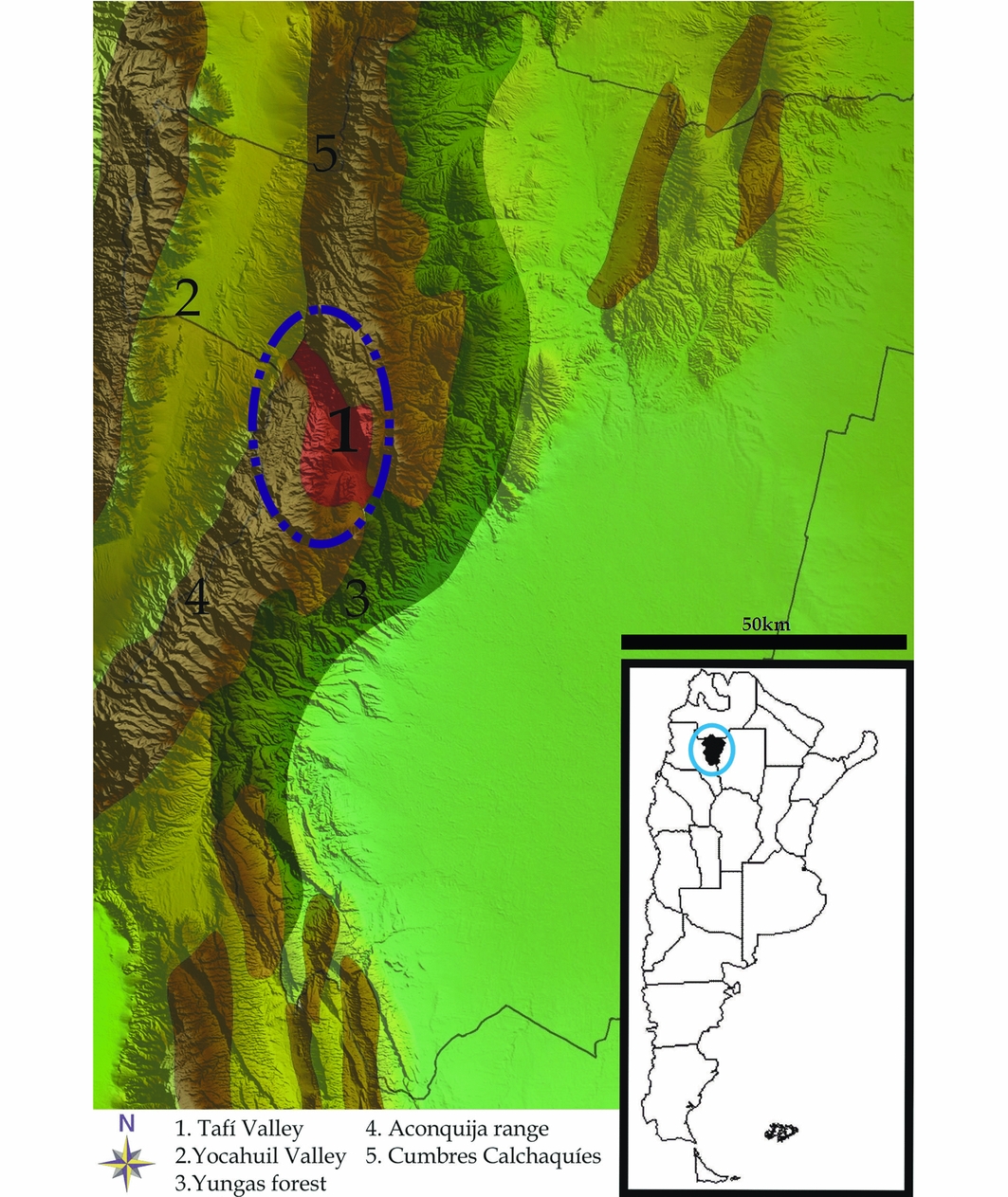
Located in the Valliserrana region of north-western Argentina, the Tafí Valley is an elongated basin crosscutting the Cumbres Calchaquíes and Aconquija mountain ranges. The valley exists as an ecotonal zone between the humid forest (or yunga) to the east and the arid highlands (or puna) to the west (Figure 1), ranging in height between 1800 and 3000m asl. In prehistoric times, the Tafí Valley served as a cultural and economic corridor by which these two areas were connected (Núñez & Dillehay Reference Núñez and Dillehay1995). In many ways, the high mountains exist as a climatic barrier, stopping Atlantic winds and creating a humid-temperate high valley, abundant summer rainfalls and highland pasturelands (Figure 2; Ruiz Huidobro Reference Ruiz Huidobro1972; Navone & Palacín Reference Navone and Palacín2000).
The Tafí Valley and the surrounding landscape of Tucumán Province, north-western Argentina.

Archaeological regions of the broader Tafí Valley. Each region contains multiple alluvial terraces.

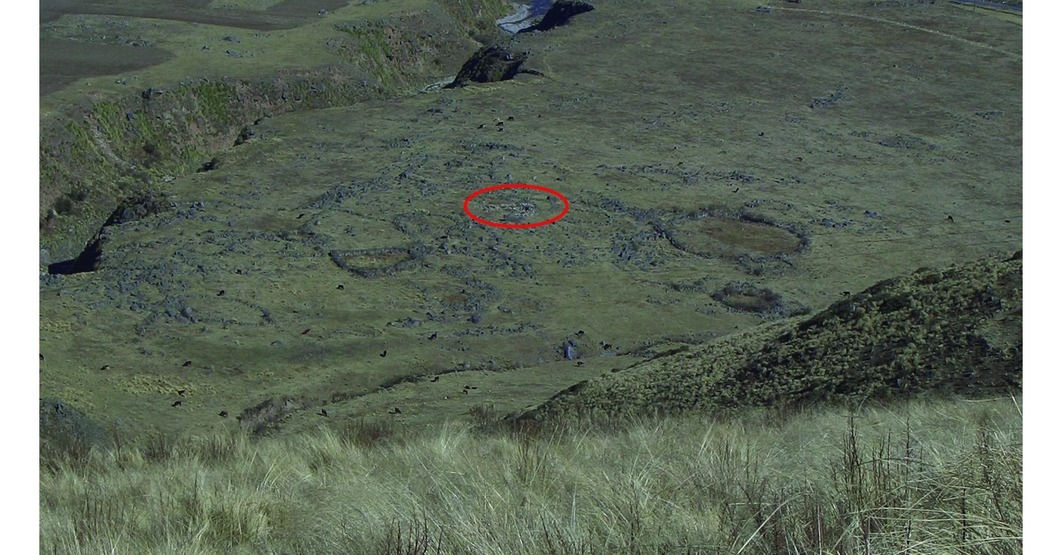
Between 200 BC and AD 850, Formative-period farmers and herders in the Tafí Valley began to settle upland areas and construct house clusters (Figure 3; González & Núñez Regueiro Reference González and Núñez Regueiro1960; Berberián & Nielsen Reference Berberián, Nielsen and Berberián1988; Sampietro & Vattuone Reference Sampietro and Vattuone2005; Oliszewski Reference Oliszewski2011; Franco Salvi et al. Reference Franco Salvi, Salazar and Berberián2014). These house clusters are composed of residential buildings and often multiple crop-growing structures and domestic camelid enclosures. Some residential clusters are isolated and dispersed across terrace areas. In other cases, however, there are numerous house clusters, associated enclosed but unroofed areas, and functionally specialised features such as corrals and crop-growing plots (canchones). In some extraordinary cases, the residential areas are associated with monolithic carved stone sculptures.
Terrace LB1, the Tafí Valley, photographed from Cumbres Calchaquíes, showing cattle grazing throughout numerous stone house clusters. The red circle marks the location of house cluster U14. Photograph by J. Salazar.

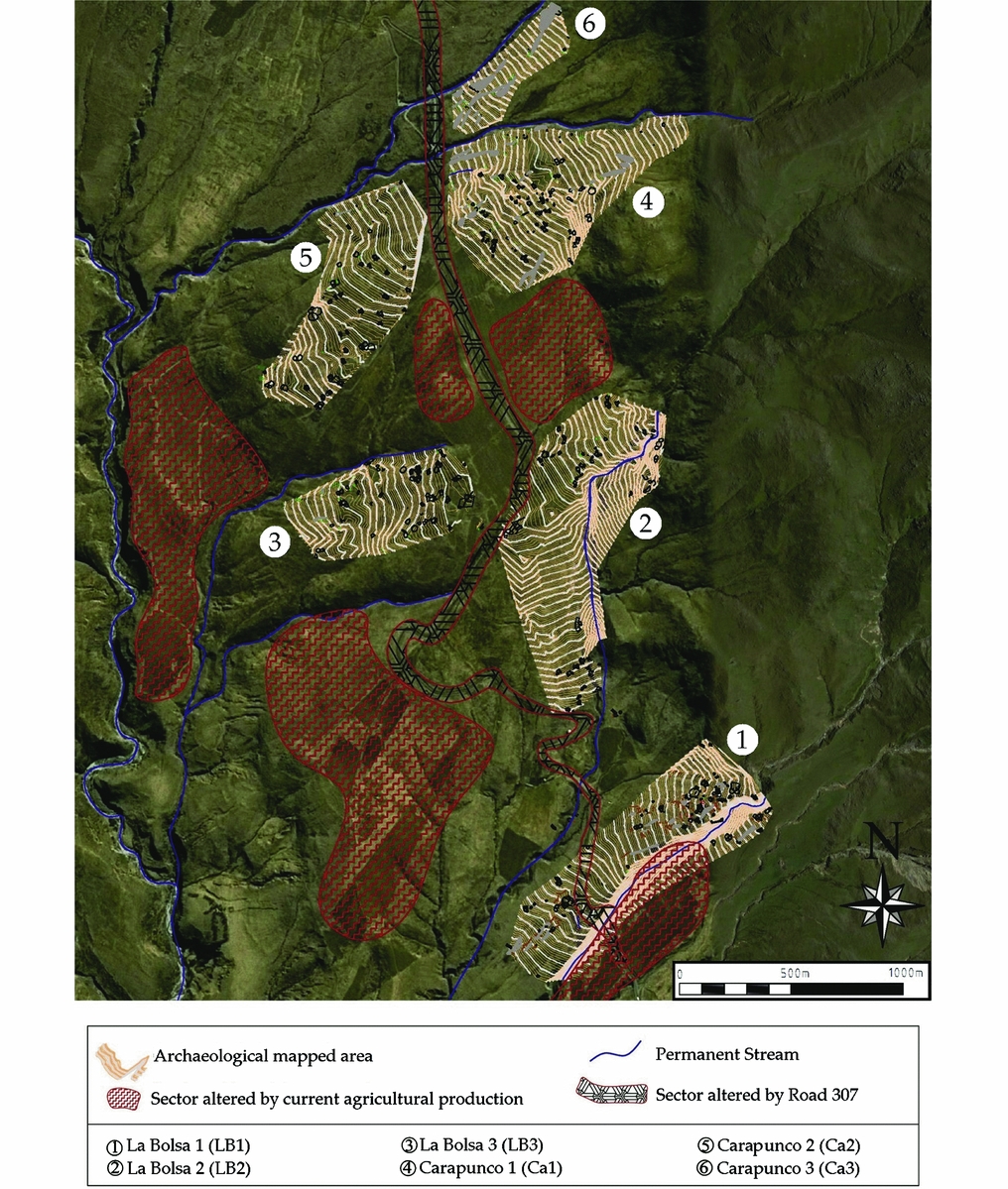
Field survey along the northern Tafí Valley has focused on a 10km2 area in the sectors of La Bolsa and Carapunco, recording all visible structures and features, and developing a regional chronology. Aerial photography has also been used to identify prehistoric structures to augment direct ground survey and topographic mapping of archaeological features. Sampling of cultural materials was conducted using transects and quadrats. This survey has identified six main areas with a high density of archaeological materials (Figure 4).
Aerial view of the northern Tafí Valley, illustrating the relatively homogeneous distribution of house clusters.

Analysis of radiocarbon-dated pottery assemblages provides researchers with a detailed understanding of the chronology of the Tafí Valley, including how buildings were often reused over several hundred years. They also provide evidence of the complex process of landscape colonisation in early village contexts. The high frequency of coarse unslipped red ceramics, fine red ceramics and low frequencies of fine grey ware produced in a reduced atmosphere, or slipped coarse and fine red and orange ceramics, indicate that most houses in the Tafí Valley were constructed between 200 BC and AD 850 (Salazar et al. Reference Salazar, Franco Salvi, Berberián and Clavero2007; Franco Salvi et al. Reference Franco Salvi, Salazar and Berberián2014). While this area had been inhabited for several thousand years before 200 BC (Martínez et al. Reference Martínez, Mauri, Mercuri, Caria and Oliszewski2013), and continued to be used after AD 1000, the major period of population growth and occupation occurred in the first millennium AD. Research in neighbouring areas demonstrates a similar pattern (Berberián & Nielsen Reference Berberián, Nielsen and Berberián1988; Cremonte Reference Cremonte1996; Sampietro & Vattuone Reference Sampietro and Vattuone2005).
The highland basins of the puna saw the emergence of several pastoralist adaptations, with dispersed and mobile settlements such as Casa Chávez (Olivera Reference Olivera1991), and clustered occupations around oases, such as Tebenquiche (Haber Reference Haber2006) and Laguna Blanca, where irrigation systems facilitated local agriculture. Along the intermountain valleys, large clustered villages transformed the local landscape with the development of irrigation systems and agriculture. There were also some scattered hamlets where household compounds were the main architectural feature (Albeck Reference Albeck and Tarragó2000). Finally, the eastern slopes of the Andes and adjacent lowlands were occupied by groups economically focused on agriculture and horticulture, but with a level of mobility similar to foragers (Albeck Reference Albeck and Tarragó2000; Quesada et al. Reference Quesada, Gastaldi and Granizo2012). Tafí Valley people lived in aggregated settlements, widely scattered across the landscape, characterised by solid and durable houses and extensive use of agriculture.
Tafí Valley Formative-period houses and patios
To understand the late Holocene expansion of human communities into the elevated Tafí Valley, researchers from Universidad Nacional de Córdoba, Argentina, have undertaken a long-term field project to locate and map all visible archaeological remains. These include stone residential buildings, compound walls, clearance cairns and water diversion systems (Franco Salvi & Berberián Reference Franco Salvi and Berberián2011). Excavations have been undertaken on residential buildings, compounds and other features. The selection of houses for excavation was based on site size, location, preservation conditions and access. Buildings were excavated down to sterile soil; all sediments were screened and all collected materials were recorded with 3D coordinates. Sedimentary, macrobotanical, flotation and radiocarbon samples were collected when possible.
Excavations and spatial analysis of roofed residential and unroofed food-processing areas (or courtyards) at terrace La Bolsa 1 (LB1) allows researchers to understand when individual houses, house clusters and the broader landscape more generally were inhabited, modified and abandoned. Formative people constructed circular or sub-circular semi-subterranean roofed buildings ranging in size from 2–20m2. These buildings were placed around a single, circular unroofed patio constructed with large upright stones, and with a single entrance connecting the patio and outside areas. At times, between 3 and 15 (mean = 5) irregular and larger structures were attached to the unroofed patio courtyard. Burial cists were often located in the centre of the courtyard, surrounded by storage features and grinding tools, with evidence of in situ use. In some cases, major portions of the patio were devoted to burial cists.
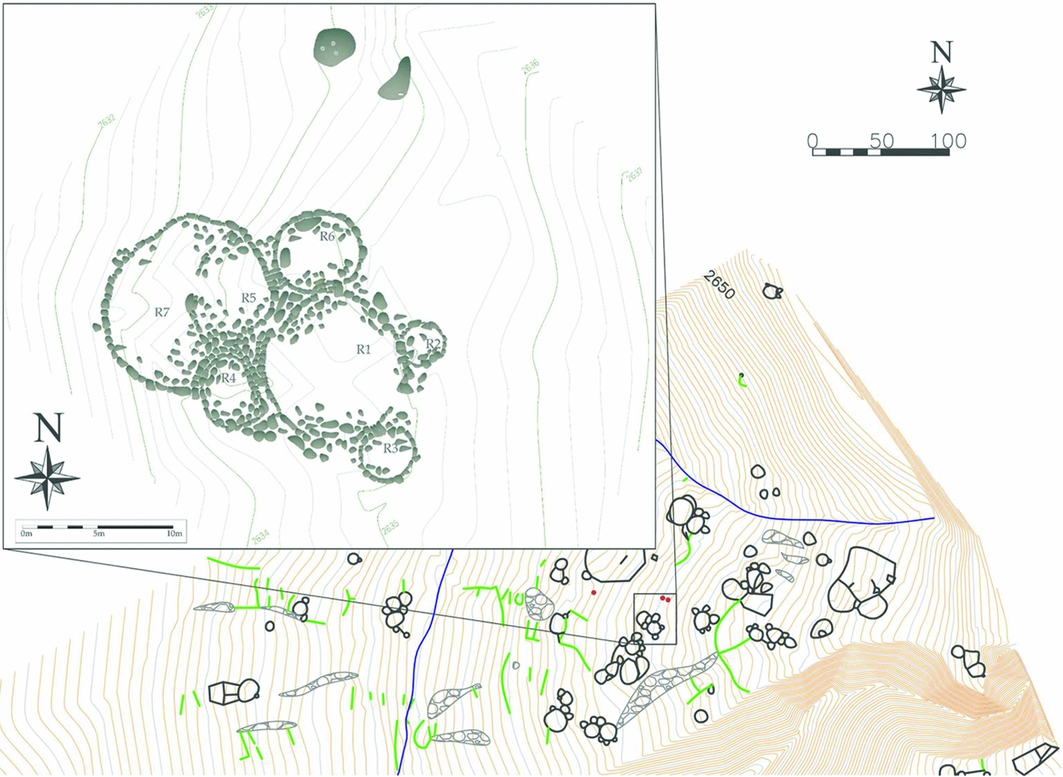
Detailed stratigraphic and radiocarbon dating of house cluster U14 has helped researchers to understand the architectural life-history of the houses. U14 is located in the densely occupied area of the LB1 settlement (Figure 5). It is organised around seven stone structures, including four circular rooms (R2, R3, R4 and R6) placed around the main courtyard (R1) and two peripheral irregular enclosures (R5 and R7) (Figure 6). The house cluster initially included central structure R1 and two attached rooms, R2 and R6, which had the main compound hearth (Figure 6). The entrance to the patio is located in the southern wall of courtyard R1. Similar to house cluster U10 (Salazar et al. Reference Salazar, Franco Salvi, Berberián and Clavero2007), the narrow entranceway to R1 clearly separated and restricted access between interior and exterior areas. Spatial analysis of access and the use of space (Hillier & Hanson Reference Hillier and Hanson1984; Blanton Reference Blanton1994) illustrates that people would have had to enter into the central courtyard before accessing other compound buildings. Typical of other compounds, a burial cist was placed in the centre of R1. This underground cist was bell-shaped, stone-walled and had a false dome cap protruding 300mm above the occupational floor. Radiocarbon dating of wood charcoal recovered from the base of the structure reveals that it was abandoned around 1799±37 BP (AA-85756: cal AD 128–333 at 95.4% confidence; date modelled in OxCal v.4.2, using IntCal13 calibration curve (Bronk Ramsey Reference Bronk Ramsey2009; Reimer et al. Reference Reimer, Bard, Bayliss, Beck, Blackwell, Bronk Ramsey, Buck, Cheng, Edwards, Friedrich, Grootes, Guilderson, Haflidason, Hajdas, Hatté, Heaton, Hoffmann, Hogg, Hughen, Kaiser, Kromer, Manning, Niu, Reimer, Richards, Scott, Southon, Staff, Turney and van der Plicht2013).
Archaeological household clusters, dated to the first millennium AD, recognised following survey of the north Tafí Valley. Highlighted in red is a detail of house compound U12 (modified from López Lillo & Salazar Reference López Lillo, Salazar and Salazar2015: 130).

Plan of the densely occupied terrace of LB1, in the Tafí Valley, and detailed floor plan of the building cluster U14 before excavation.

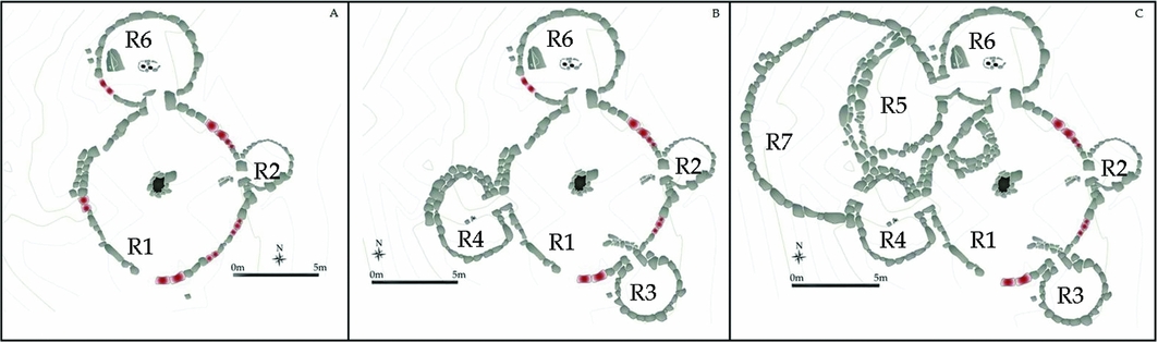
Formative people constructed, used and modified their buildings over time. These actions were probably related to population growth or changes in family structure. As illustrated by house cluster U14 (Figure 7), buildings were used for over 600 years or more in some cases. After the initial construction at around AD 200, two new rooms (R3 and R4) and a new hearth were added to the original compound. These additions maintained the original structural configuration, and reflect long-term use of these buildings. Later, a large semi-circular peripheral enclosure with internal subdivision was added to form R5 and R7. There is no stratigraphic evidence for multiple occupational floors, probably due to the long-term curation and cleaning of spaces, erasing evidence of earlier occupations. Additionally, the central burial cist was reused, with the foundational burial and associated vessels being moved to the side of the tomb, having capped the burial with a new deposit, built a fire over the new soil covering, and then interred a new burial and a grey bowl. Finally, an intentionally broken anthropomorphic stone figurine was placed in the cist. Echoing other regional Andean prehistoric practices, these mortuary rites illustrate the physical and symbolic connections between the ancestral dead and the living community (Hastorf Reference Hastorf2003; Aschero Reference Aschero, Nielsen, Rivolta, Seldes, Vázquez and Mercolli2007; Arriaza et al. Reference Arriaza, Standen, Cassman, Santoro, Silverman and Isbell2008).
The architectural development of house cluster U14, terrace LB1: A) the construction of the courtyard and rooms R1 and R2, AD 200; B) the addition of new rooms, R3 and R4, AD 200–700; C) the addition of another courtyard and additional rooms, R5 and R7, AD 700–850.

The house cluster was intentionally abandoned around AD 850, with the doors to the two rooms being blocked and people covering the hearth with large rocks. The burial cist in the patio of house U14 was created around AD 128–333. Four radiocarbon dates from the occupation floors demonstrate that this building was still in use around AD 690–860 (Salazar Reference Salazar2012).
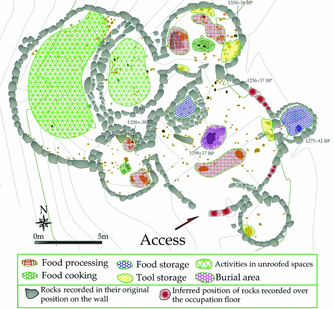
Excavations show that people ground maize and stored food within the central unroofed courtyard R1. A grinding tool assemblage of metates and manos was recovered from a primary undisturbed occupation floor. Microscopic archaeobotanic analyses of soil samples (Rocio Molar, UNC Prehistory & Archaeology Laboratory) recognised phytoliths and starch grains from maize (Zea mays) (single, polyhedral, spherical and irregular-elongated, variable in size from 15–35µm, distinct centric hilum as a dot or line, some distinct lamella and distinct centric cross with four arms visible); and starch grains from beans (Lupinus mutabilis) (single, oval, 38µm, indistinct centric hilum, not visible lamella, lightly eccentric cross with four arms visible, distinct border). The presence of these microbotanical elements in the sediments around the grinding tools demonstrates that maize-grinding occurred in situ. A discrete feature was built against a clear area of the patio main wall, and contained big, coarse-fabric vessel fragments. Maize phytoliths from leaves and husks were recovered from the sediments of this feature. There is also evidence for the ritual discard of clay animal figurines representing male and female camelids. These tiny figurines have broken limbs and heads, possibly intentionally fragmented before being discarded. Sherds of imported pottery from non-local sources were also found in these deposits. This highlights the symbolic integration of domestic, ritual and household activities in courtyard spaces (Figure 8).
House cluster U14, terrace LB1, showing artefact distribution and the inferred differential use of courtyards and house areas.

The excavation of peripheral rooms highlights that people used different areas in a variety of ways. A few broken cooking vessels were found around the central oval stone hearth in R6, along with maize starch grains. The pottery assemblage recovered from R6 provides evidence of food-processing and the cooking and serving of food. The vessels were predominantly medium-sized pots (150–250mm mouth diameter) and small-sized bowls (less than 100mm mouth diameter). A secondary cooking area was identified in R4. The smallest room, R2, exhibits evidence for the storage of tubers in the form of starch grains, including an as yet undefined variation of Andean potato. Larger structures (R5 and R7) were probably unroofed and used for making stone tools.
House cluster distribution across alluvial terraces
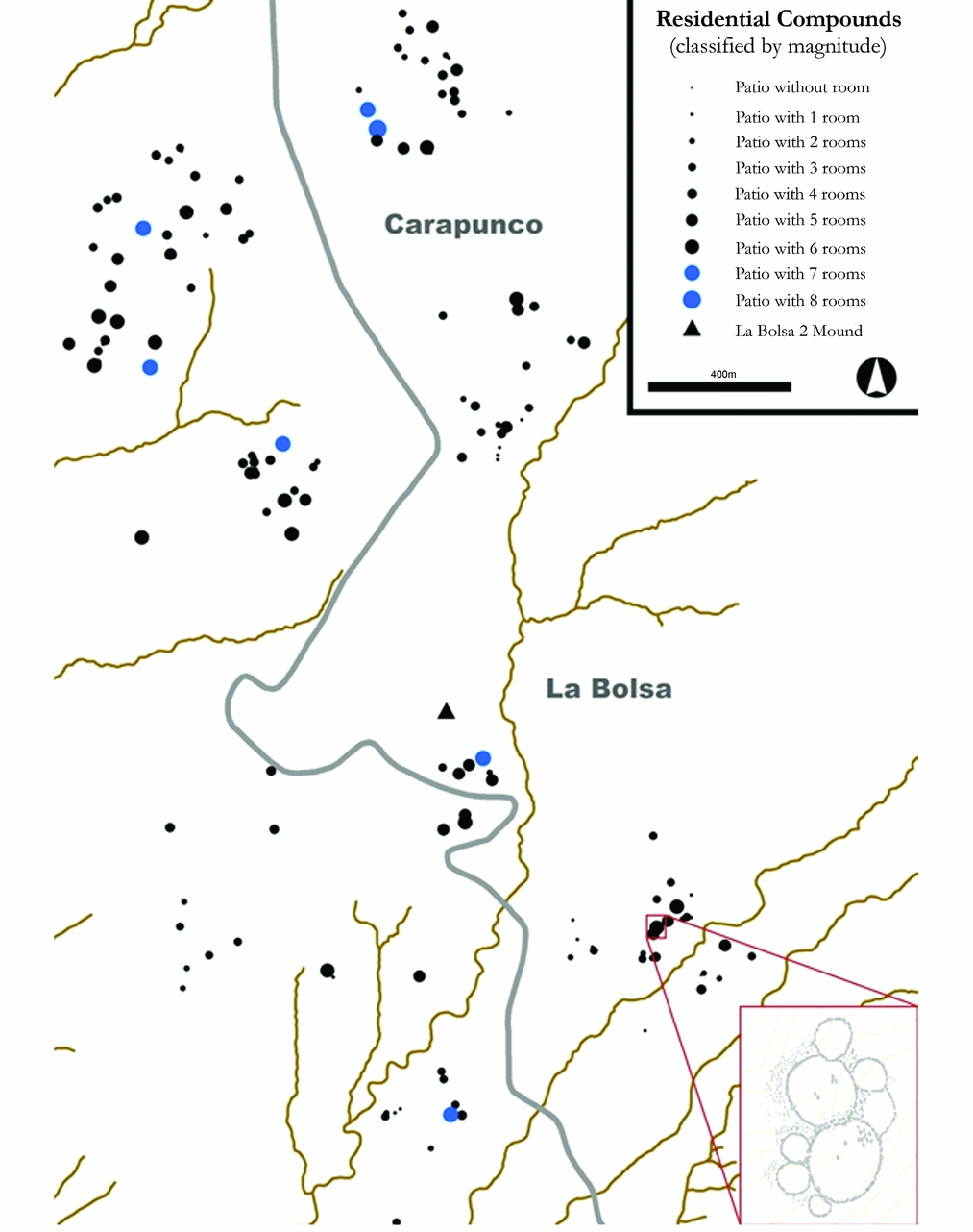
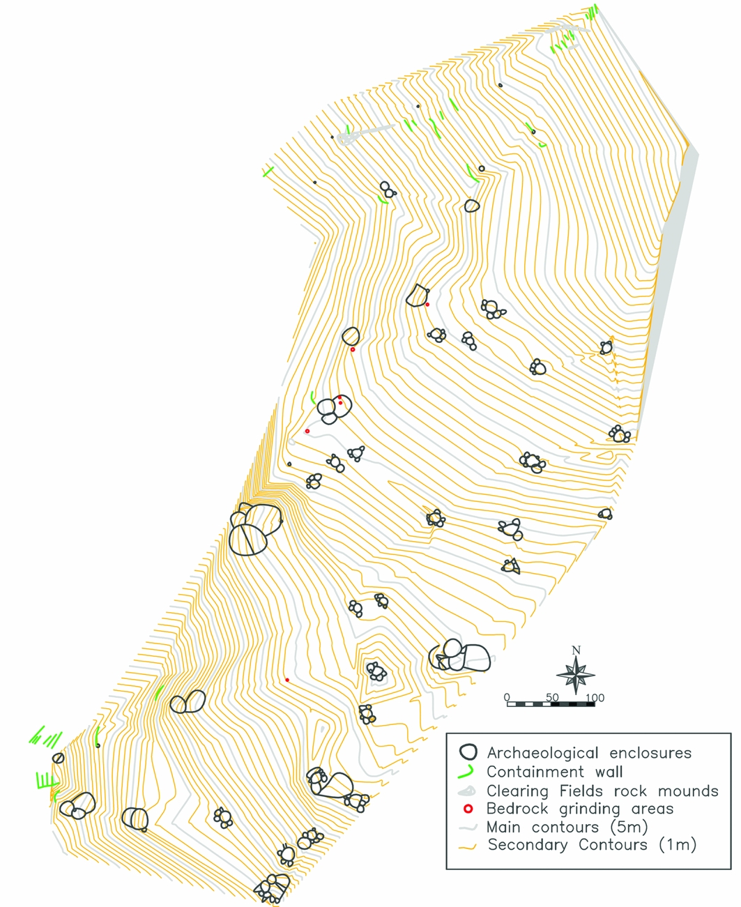
House clusters were the central nodes around which daily life in the Formative period was organised. People built clusters on terraces LB1, 2 and 3, as well as Ca1 and Ca2, so that one or more compartmentalised, roofed residential buildings were placed around an unroofed courtyard. Each cluster is between 2 and 100m away from other residential clusters (Figure 9). The spatial separation of house clusters supports arguments for a degree of household independence. The presence of at least 100 house clusters within the survey area (average of 9.1 house compounds per km2) provides testimony to the extensive long-term use of the landscape. In some cases, there appears to have been an aggregation of house clusters in specific areas. There were no plazas or public places in the settlements.
Distribution of house compounds across terrace Ca2 in the Tafí Valley.

In addition to house clusters, Formative people constructed agricultural outbuildings and field systems. Outbuildings were often used over many years. Field systems were not large, but they form clearly delimited plots defined by stone wall enclosures (canchones), terraces shaped by perpendicularly attached containment walls, as well as elongated rock mounds created by clearing field areas. Field modifications, which never exceed 400m², include visually distinguishable rock mounds, terraces and enclosures.
Changing settlement and household systems over time
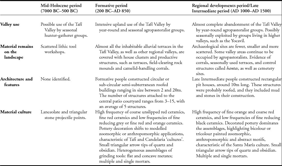
Excavation and radiocarbon dating of remains within the Tafí Valley has allowed researchers to reconstruct the shifting residential and economic practices over almost fifteen centuries. In brief, the remains of spatially discrete house clusters along alluvial terraces reflect complex palimpsests produced by short-term individual house histories, as well as long-term occupational continuity and maintenance of cultural practices (Table 1; Figure 10).
Comparative aspects of mid-Holocene to Late Intermediate period material record of the Tafí Valley, north-western Argentina.

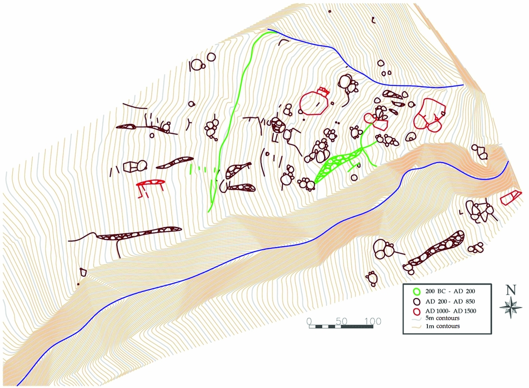
Spatial distribution of the mid-Holocene period (200 BC–AD 200), Formative period (AD 200–AD 850) and Late Intermediate period (AD 1000–AD 1500) house clusters and water control features of terrace LB1 in the Tafí Valley.

As seen in Figure 10, and summarised in Table 1, archaeological survey and excavations along alluvial terrace LB1 show that around the second century BC, people built features relating to seasonal irrigation and food production. The earliest evidence of occupation, seen in green in Figure 10, comes from an excavated midden and a water-drainage system. Available data demonstrate the development of low-scale food production and the presence of agriculture in the region before the first century AD. Recovered animal fauna include Camelidae sp., radiocarbon-dated to 2110±66 BP (AA81302: 359–274 BC and 261 BC–AD 20 at 95.4% confidence; date modelled in OxCal v.4.2, using IntCal13 calibration curve (Bronk Ramsey Reference Bronk Ramsey2009; Reimer et al. Reference Reimer, Bard, Bayliss, Beck, Blackwell, Bronk Ramsey, Buck, Cheng, Edwards, Friedrich, Grootes, Guilderson, Haflidason, Hajdas, Hatté, Heaton, Hoffmann, Hogg, Hughen, Kaiser, Kromer, Manning, Niu, Reimer, Richards, Scott, Southon, Staff, Turney and van der Plicht2013)) (Franco Salvi & Berberián Reference Franco Salvi and Berberián2011). Other remains include an agricultural terrace where a cache of a llama (Lama glama) offering was recovered. This ritual cache included the skull and four flexed articulated limbs of an adult llama, covered by a small rock mound. Dating to 1883±46 BP (AA89140: AD 25–240 at 95.4% confidence; date modelled in OxCal v.4.2, using IntCal13 calibration curve (Bronk Ramsey Reference Bronk Ramsey2009; Reimer et al. Reference Reimer, Bard, Bayliss, Beck, Blackwell, Bronk Ramsey, Buck, Cheng, Edwards, Friedrich, Grootes, Guilderson, Haflidason, Hajdas, Hatté, Heaton, Hoffmann, Hogg, Hughen, Kaiser, Kromer, Manning, Niu, Reimer, Richards, Scott, Southon, Staff, Turney and van der Plicht2013)), these remains illustrate the past presence of agricultural fertility rites (Franco Salvi & Berberián Reference Franco Salvi and Berberián2011). Despite extensive archaeological excavation on terrace LB1 and other terraces, no evidence has been uncovered for pre-Formative residential structures. This highlights that the initial pre-Formative colonisation focused on the seasonal use of alluvial terrace LB1.
Formative people first constructed residential buildings, often in clusters, on terrace LB1 and the broader valley around 1800 years ago. In the case of the U14 residential cluster, construction was driven by gradual regional demographic increases, as well as household life cycle. Starting around AD 200, there was a transition towards the construction of residential buildings, compounds, terracing systems and corrals (Figure 10, marked in brown). These remains testify to new practices of intensified year-round land use, as well as to a significant increase in the number of people living in upland locations. The use of individual house clusters continued for several generations, and in some cases, for over five centuries.
Radiocarbon dating of buildings highlights that around AD 850, many people began to abandon their dwellings and the Tafí Valley. In the case of terrace LB1, post-AD 850 construction was limited to a few large corrals (Figure 10, marked in red), some of which were constructed in the Late Intermediate Period (AD 1000–AD 1500), and others in the historic colonial or republican period. The pattern seen on terrace LB1 is broadly representative of the entire valley, with the regional shift from the intensive occupation of valley areas in the Formative, to the post-Formative construction of corrals, used only occasionally for stock control. This abrupt, almost total shift, has led some scholars (e.g. Tarragó Reference Tarragó1989) to propose that between AD 1000 and AD 1500, the valley was exclusively used by seasonal colonies of herders that came from higher valleys.
Conclusion
Archaeological research in the Tafí Valley allows us to document and model Formative settlement and the expansion of human communities into marginal upland areas. Excavation of house clusters along the alluvial fans provides evidence for an initial chronology of clusters across the Tafí Valley. Research in different terraces illustrates that house clusters date to between 200 BC and AD 850. Although the Tafí Valley was inhabited several thousand years before this point (Martínez et al. Reference Martínez, Mauri, Mercuri, Caria and Oliszewski2013), and continued to be used after AD 1000, the majority of the occupation and expansion into this valley dates to the first millennium AD (Table 1). Almost all of the inhabitable terraces in the northern Tafí Valley, as well as other regional valleys, are covered with house clusters. While clearly a palimpsest of human occupation, these dense concentrations of house clusters demonstrate the significant influx of people into elevated valley areas where new food-production systems led to population growth and facilitated the colonisation of previously unused environmental zones.
The long-term stability of the Formative-period economic system, materialised in individual house clusters, was founded on seasonal collective labour for llama herding, constructing field systems and agricultural tasks. At the same time, the dispersed nature of Formative-period house clusters across terraces reflects a high degree of household autonomy. This successful system, maintained for almost a millennium, allowed household members to focus on farming and herding, to live in the valley while avoiding the pitfalls of institutional inequality and village overcrowding. Households were not, however, completely autonomous, nor were new houses built exclusively in response to household fission. Indeed, the members of these houses must have been connected through marriage. It is probable that supra-household organisations created communal networks and linked domestic, economic and ceremonial life. The strategy of keeping social and spatial distance between kinship groups within dispersed terrace communities is also seen in other early agricultural case studies from the southern Andes (Haber Reference Haber2006; Quesada et al. Reference Quesada, Gastaldi and Granizo2012).
This archaeological research supports arguments for Formative population growth and large-scale expansion into more marginal areas in north-western Argentina. Interestingly, however, the adoption of agropastoralism did not result in the formation of large aggregate villages, or larger, more powerful households, within this constricted Andean corridor. Although the adoption of agriculture resulted in regional population increases, it was materialised locally as spatially diffuse and heterogeneous households spread over alluvial fans. This process may be the consequence of repeated fission cycles within households and the construction of new house clusters. Bandy (Reference Bandy2005, Reference Bandy, Bandy and Fox2010) argues that such fission cycles were typical of early village societies, generated by the social tensions within growing communities, but were often held in check by communal and ritual institutions. Although there is no evidence for overarching communal institutions in the Tafí Valley, excavations illustrate that ritual practices were focused on the worship of household ancestors, with the burial of the family dead within courtyards. This household-level organisation may well have involved community-oriented household kinships, broadly consistent with ethno-archaeological studies of low-level egalitarian communities (Graham Reference Graham1994; Stone Reference Stone1994).
Acknowledgements
This research has been generously supported by CONICET (Consejo Nacional de Investigaciones Científicas y Técnicas), Centro de Estudios Históricos ‘Prof. C.S.A. Segreti’, Universidad Nacional de Córdoba, Argentina, and MinCyT (Ministerio de Ciencia y Técnica, Provincia de Córdoba). This study would not have been possible without the kindness and assistance of E.E. Berberián, V. Franco Salvi, D. Rivero, M.L. López, R. Molar, J. López Lillio, G. Heider and V. Gazi. The NSF-Arizona AMS Facility generously provided radiocarbon dating for this research. This publication was written while J. Salazar was a post-doctoral fellow at the Department of Anthropology, University of Notre Dame, and while I. Kuijt was a distinguished fellow at the Notre Dame Institute for Advanced Studies. Our thanks go to A. Nielsen, N. Oliszewski, B. Bixio, D. Glowacki and multiple anonymous reviewers for constructive comments that have greatly improved the clarity, focus and comparative perspective of this essay.