Recent research and reassessments of the data from Chichen Itza now place the period of monumental construction and elite activity at the site squarely in the Terminal Classic period (a.d. 800–1000), beginning in the latter part of the ninth century and lasting until perhaps the mid-eleventh century (Andrews et al. Reference Andrews, Andrews and Castellanos2003). The result of this chronological realignment is a growing recognition that the same processes that led to the ninth-century “collapse” in the southern Maya lowlands likely affected the northern lowlands as well, linking the two regions in terms of trajectories of sociopolitical complexity. At the same time, the placement of Chichen Itza's height of regional power and influence squarely in the ninth and tenth centuries, at a time in which the entire northern lowlands likely reached its greatest population density, holds profound implications for understanding the rapid growth of Chichen Itza and its relationship with neighboring polities.
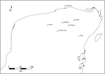
Unlike most sites in the northern lowlands, the ancient Maya center of Xuenkal (Figure 1), located 45 km northeast of Chichen Itza, demonstrates significant occupations associated both with the Late Classic–Terminal Classic Cehpech ceramic sphere and the Terminal Classic Sotuta sphere, the latter strongly associated with Chichen Itza. In this article we present recent findings from Xuenkal, located approximately halfway between Chichen Itza and its northern port of Isla Cerritos, which illustrate the complex relationships that linked Terminal Classic Xuenkal households into Chichen Itza's regional economy.
Location of Xuenkal on the Yucatan Peninsula.

LATE CLASSIC–TERMINAL CLASSIC TRANSFORMATIONS IN NORTHERN YUCATAN
Recent chronological refinements demonstrate that the timing of the collapse of most northern lowland polities is contemporary with a period of dramatic growth witnessed at Chichen Itza, yet the demographic transformations implied by such a scenario have not been explored. While the two processes are entwined, the causes behind the collapse of most polities and the rapid growth of Chichen Itza remain poorly understood. An examination of the case of Xuenkal suggests that monolithic models that equate the presence of Sotuta sphere ceramics—so closely associated with Chichen Itza—with direct political domination overlook important regional variation and portray peripheral communities as passive recipients of conquest. Our central question concerns the way in which household economies at Xuenkal shifted in response to periods of intense sociopolitical change. Rapidly changing political economies during this tumultuous period are implicated in a decline of local administrative authority, a substantial demographic decline, and the emergence of an unprecedented degree of household production and exchange.
Scholars have long argued that Chichen Itza was the dominant force in the region, controlling or perhaps even founding trading enclaves along the coast of Yucatan, particularly in the case of Isla Cerritos (Andrews et al. Reference Andrews, Negrón, Robles, Cobos and Cervera1988; Andrews and Gallareta Negrón Reference Andrews and Negrón1986; Gallareta Negrón Reference Gallareta Negrón1998; Robles Castellanos Reference Robles Castellanos1988), and serving as a key pilgrimage center in Terminal Classic Mesoamerica for rites of investiture (Ringle Reference Ringle2004; Reference Ringle2009; Ringle et al. Reference Ringle, Negrón and Bey1998), but virtually nothing is currently known about how the local interior region was integrated within Chichen Itza's expansionary political system. In the case of Xuenkal, Terminal Classic households were tightly integrated into the Chichen economy, acquiring substantial quantities of central Mexican obsidian and Sotuta ceramics likely produced near Chichen Itza. At the same time, households were heavily invested in producing textiles and shell ornaments well beyond quantities for household subsistence (Ardren et al. Reference Ardren, Manahan, Wesp and Alonso2010). The scale and intensity of household economic strategies may indicate an adaptation to Chichen's political economy, whose focus extended well beyond luxury goods or, alternatively, may indicate that households were required to meet tribute burdens.
During this period other northern lowland centers were either abandoned and lack evidence of Sotuta occupation, such as Coba (Robles Castellanos Reference Robles Castellanos1990) and Oxkintok (Varela Torrecilla Reference Varela Torrecilla1998); or they contained very limited quantities of Sotuta materials in discrete areas within their latest contexts, such as Uxmal (Barrera Rubio and Huchim Herrera Reference Barrera Rubio, Herrera and Breton1989) and Dzibilchaltun (Andrews and Andrews Reference Andrews and Andrews1980). Evidence from the site of Yaxuna, 20 km south of Chichen Itza, shows the presence of Sotuta ceramics in limited contexts (Suhler et al. Reference Suhler, Ardren and Johnstone1998; Suhler et al. Reference Suhler, Ardren, Freidel, Johnstone, Demarest, Rice and Rice2004). In contrast, Sotuta ceramics are virtually absent from Ek' Balam 25 km to the northeast of Chichen Itza and only 20 km east of Xuenkal (Bey et al. Reference Bey, Bond, Ringle, Hansen, Houck and Lope1998; Ringle Reference Ringle2004). Sotuta ceramics do appear, however, in substantial quantities at Kuluba to the east of Ek' Balam (Barrera Rubio et al. Reference Barrera Rubio, Lope, Sánchez and Carrillo2003) and in the Chikinchel region to the north of Ek' Balam (Kepecs et al. Reference Kepecs, Feinman and Boucher1994).
The paucity of Sotuta material encountered outside of Chichen Itza and associated coastal trading communities (and the overwhelming abundance of Sotuta within these locales), has led many scholars to equate the presence of Sotuta material with direct political control by the Chichen Itza state. The diversity of evidence suggests, however, that the nature of the relationship between the presence of Sotuta ceramics and the state of Chichen Itza is complex and likely varied across space and time. We argue that Sotuta remains are the material correlates of diverse economic and political strategies by actors from both Chichen Itza and peripheral communities. As such, Sotuta material may be seen to reflect participation in Chichen Itza's broader economy without necessarily requiring direct state control.
Chichen Itza's political strategies in the region may have included subordination of rival communities, domination with the threat of military conquest, or regional isolation, among others, and surely these strategies varied through time. Political control over neighboring regions bore economic benefits whether through integration of new communities into a regional mercantile economy or leveraged through the extraction of tribute. Some sites, like Isla Cerritos (Andrews et al. Reference Andrews, Negrón, Robles, Cobos and Cervera1988), with its Chichen-inspired architectural forms and substantial quantities of imports are unequivocal examples of direct political control and its economic benefits. Typically the evidence is more ambivalent. In the case of Xuenkal, the site's location halfway between Chichen Itza and Isla Cerritos meant that it likely served as a way station along the route connecting the center to the coast (Andrews et al. Reference Andrews, Negrón and Palma1989; Ardren and Lowry Reference Ardren and Lowry2011), yet evidence for direct external political control is lacking. In economic terms, however, Terminal Classic households strongly integrated themselves into the regional market, seen in the proliferation of Sotuta ceramics, access to exotic central Mexican obsidian, and the production of shell ornaments and textiles. When compared to earlier Cehpech households, one may argue that Terminal Classic households at Xuenkal were more tightly integrated into the distant Chichen Itza political economy than Late Classic households were to the local centralized authority. The increased scale and intensity of household production may be a reflection of new access to an expanding regional market or, alternatively, a strategy to meet tribute demands placed by Chichen Itza.
CHRONOLOGIES, CERAMIC SPHERES, AND MODELS OF OVERLAP
The temporal placement of the Cehpech and Sotuta ceramic spheres has been problematic since their formal definition by Robert Smith in 1970 for a variety of reasons (Anderson Reference Anderson1998). Models have changed from positing no chronological overlap between the spheres (Brainerd Reference Brainerd1958; Smith Reference Smith1971; Valliant Reference Valliant1927), to complete overlap (Anderson Reference Anderson1997, Reference Anderson1998; Ball Reference Ball and Mills1979, Reference Ball, Sabloff and Andrews1986; Lincoln Reference Lincoln, Sabloff and Andrews1986, Reference Lincoln1990), to the recognition of partial overlap that may vary across space (Andrews and Robles Castellanos Reference Andrews, Castellanos, Chase and Rice1985; Bey et al. Reference Bey, Hanson and Ringle1997, Reference Bey, Bond, Ringle, Hansen, Houck and Lope1998; Manahan and Ardren Reference Manahan and Ardren2010; Robles Castellanos Reference Robles Castellanos, Rice and Sharer1987, 1990, Reference Robles Castellanos, Carrión and Cook2006; Robles Castellanos and Andrews Reference Robles Castellanos, Andrews, Sabloff and Andrews1986). Recent treatment by A.P. Andrews, E.W. Andrews, and Robles Castellanos (Reference Andrews, Andrews and Castellanos2003) makes clear that little, if any, chronological gap separates Terminal Classic Chichen Itza, associated almost exclusively with Sotuta ceramics, from the Late Classic to Terminal Classic Cehpech-producing and -consuming centers of both the Puuc zone, such as Uxmal, Labna, and Kabah, as well as those of the eastern Cehpech sphere, such as Coba, Ek' Balam, and Yaxuna. Thus the Cehpech and Sotuta spheres in the Type-Variety system for northern Yucatan as currently employed include both temporal and spatial components.
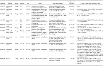
In an effort to better define the temporal aspect of these ceramic spheres, a total of 12 carbon samples were submitted for dating to the NSF-Arizona AMS Facility from secure excavated Cehpech and Sotuta contexts at Xuenkal (Table 1). The results of the radiocarbon assays are mixed. Half of the samples (Samples AA86755, 86762-65) yielded outlying calibrated dates that are unacceptably recent and are likely the result of more recent organic material that entered the record during the historic occupation of Hacienda Xuenkal. But the other six samples provided valuable chronometric data from sealed contexts and provide a crucial new addition to the literature.
Radiometric age determinations for Xuenkal, Yucatan, Mexico. Dates calibrated using CALIB Rev 6.1.0 with the IntCal09 calibration curve (Reimer et al. Reference Reimer, Baillie, Bard, Bayliss, Beck, Blackwell, Bronk Ramsey, Buck, Burr, Edwards, Friedrich, Grootes, Guilderson, Hajdas, Heaton, Hogg, Hughen, Kaiser, Kromer, McCormac, Manning, Reimer, Richards, Southon, Talamo, Turney, van der Plicht and Weyhenmeyer2009)

Similarities between Cehpech and Sotuta sphere ceramics as well as inconsistencies in the use of terminology and its chronological interpretations between sites and regions in Yucatan inevitably have resulted in confusion. Based upon the results of radiocarbon assays and ceramic chronologies, we place the chronological end of the Cehpech sphere at Xuenkal early in the Terminal Classic period, ending in the first half of the tenth century, if not before. Unfortunately only one out of four samples from Cehpech contexts produced an acceptable date, so this placement remains speculative. This chronology is consistent, however, with a recent “compromise chronology” that incorporates ceramic, architectural, and obsidian data from the Puuc area as proposed by Braswell, Paap, and Glascock (Reference Braswell, Paap and Glascock2011). Based upon a limited number of radiocarbon dates at Xuenkal, we suggest a short but significant temporal gap of approximately 25 to 75 years separating constructions containing exclusively Cehpech material from Sotuta constructions. The radiocarbon assays from Structure 8M-1, a large Sotuta platform discussed later in this article, squarely place the onset of the sphere in the mid-to-late tenth century and the cessation of constructions bearing Sotuta material by the mid-twelfth century at the latest. We refer to the Sotuta sphere as Terminal Classic in acknowledgement of the chronological refinements of Andrews et al. (Reference Andrews, Andrews and Castellanos2003) and others.
While the brief gap between spheres reflects the dramatic cultural change that differentiates the two occupations, it does not necessitate endorsement for a model that sees no overlap between spheres. Indeed there exists some degree of overlap between the two spheres at Xuenkal. The problem in trying to define the overlap stems from several issues. First, at Xuenkal it is difficult to distinguish the Sotuta type Dzitas Slate from the Cehpech type Muna Slate (as well as Sotuta Dzibiac Red from Cehpech Teabo Red) in lots that are otherwise Cehpech. Most diagnostics are subtle modal differences and variation in forms—traits that are not considered in a Type-Variety analysis. Nevertheless, it seems clear that Sotuta types such as Dzitas Slate may form low frequencies (< 5–10% in total) of lots from some Cehpech structures in the site center. A related issue concerns the ubiquity of Sotuta ceramics. Earlier surface collections across the site core identified a disproportionate amount of Sotuta material from both on- and off-mound contexts. Excavations of Sotuta structures have shown that access to ceramics dramatically increased and the ceramic densities from Sotuta contexts are typically two to five times the amount from equivalent Cehpech contexts.
Before research at Xuenkal, extensive occupations associated with Sotuta sphere ceramics apart from coastal settlements were limited to Chichen Itza and its immediate environs. The monumental constructions in the core of Xuenkal appear to be associated with ceramics from the Late Preclassic through the Late-Terminal Classic periods. Settlement associated with Cehpech ceramics has been documented extending into the hinterlands, while a substantial yet discrete Sotuta occupation has been identified exclusively within the site center. Analyses of the ceramics from five discrete Late and Terminal Classic residential loci have elucidated three distinct ceramic contexts: (1) exclusively Cehpech, (2) Cehpech containing limited Sotuta material, and (3) exclusively Sotuta. These five areas of extensive horizontal exposure are presented below. They consist of Structure 9M-14, associated exclusively with Cehpech; Structures 9M-136 and 10M-27, which contained occupational evidence of Cehpech with limited Sotuta diagnostics but with construction fill of exclusively Cehpech material; Structure 9L-31, which consisted of a Late Preclassic terrace associated with the largest temple at the site overlain by several superficial residential Sotuta constructions; and Structure 8M-1, a Sotuta platform constructed in multiple phases that supported four Sotuta superstructures and encased remains of an earlier construction associated with Cehpech material mixed with some Sotuta ceramics. In each case, the architecture and layout of the buildings associated exclusively with Sotuta materials were readily distinguishable from Cehpech patterns, whereas structures containing Cehpech mixed with limited Sotuta ceramics were indistinguishable from ones lacking Sotuta entirely.
Given the stratigraphic data and distinctive Sotuta settlement patterns discussed below, we suggest that Xuenkal underwent three distinct episodes late in its political history. First, regional ties were strongest with Cehpech-producing neighboring polities such as Ek' Balam, Izamal, Kuluba, and Tzebtun during the Late Classic period. The presence of limited Sotuta ceramics in otherwise Cehpech contexts by perhaps a.d. 850, or even earlier, marks the emerging regional importance of Chichen Itza in the local Xuenkal economy and need not imply any direct control by the urban neighbor. Only after the collapse of local centralized administrative control and the cessation of monumental construction were new constructions associated exclusively with Sotuta sphere materials undertaken, sometime most likely in the mid-to-late tenth century. In addition to new constructions, some previously abandoned Cehpech structures were reoccupied and modified by people using exclusively Sotuta sphere pottery. To date, no evidence exists to suggest that any inhabitants continued to produce or consume Cehpech sphere ceramics during this time. In the aftermath of the collapse of local centralized authority at Xuenkal, a network of compounds with close economic ties to Chichen Itza emerged in place of Cehpech households. While the Late Classic Palace seems to have been largely abandoned by the time of the new constructions, evidence for any direct political control over Xuenkal by agents of Chichen Itza remains ephemeral. This pattern is consistent with Marcus' (Reference Marcus, Sabloff and Henderson1993) dynamic model, in which Late Classic Maya secondary states experienced alternating forces of expansion, absorption, and segmentation.
PROYECTO ARQUEOLOGICO XUENKAL AND THE CUPUL REGION
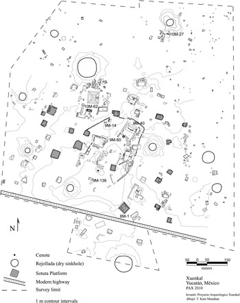
Xuenkal was first recorded as a Rank II category site in the classification system determined by the Atlas Arqueológico del Estado de Yucatan and is considered of urban proportions, although not on the same scale as the Rank I site of Chichen Itza (Garza Tarazona and Kurjack Reference Garza Tarazona and Kurjack1980). Xuenkal and several neighboring centers were briefly revisited in 1988 when members of the Cupul Survey (Andrews et al. Reference Andrews, Negrón and Palma1989) produced sketch maps of the site centers and collected surface artifacts. The surface collections from Xuenkal were noteworthy in that they contained significant amounts of diagnostic Sotuta ceramics. No other archaeological research had been conducted in the region prior to the summer of 2003, when a project directed by the Instituto Nacional de Antropología e Historia (INAH) mitigated several smaller structures impacted by road construction (Burgos Villanueva et al. Reference Burgos Villanueva, Uh and Salas2004). With INAH permission, Ardren and Manahan initiated the Proyecto Arqueologico Xuenkal (PAX) in 2004 with the first of four subsequent field seasons. To date, PAX has mapped over 600 structures within the 1 km2 urban core of the site (Figure 2), surveyed an additional 0.8 km2 of the periphery, excavated 120 off-mound test pits to establish site chronology, fully excavated 6 residential structures, performed a botanical survey of 22 rejolladas, doline sinkholes whose bases remain above the water table, and initiated regional reconnaissance and mapping of the hinterlands and the 0.1 km2 core of the secondary center of Dzadz Naranja (Ardren et al. Reference Ardren, Villanueva, Manahan, Góngora and Faisal2005; Manahan and Ardren Reference Manahan and Ardren2010).
Map of the core area of the ancient settlement of Xuenkal.

The Xuenkal region is located in the northeastern portion of the state of Yucatan, and the physical geography of the region is consistent with much of the northern Maya lowlands. This portion of the peninsula consists of an expansive karstic limestone plain characterized by flat topography, soils generally less than 1 m thick, extensive bedrock outcroppings, and numerous dissolution depressions or sinkholes (Lesser and Weidie Reference Lesser, Weidie, Back, Rosenshein and Seaber1988; Munro-Stasiuk and Manahan Reference Munro-Stasiuk and Manahan2010; Weidie Reference Weidie, Ward, Weidie and Back1985).
Through four field seasons of research at Xuenkal, we have documented the history of a center that was settled by the Late Preclassic (300 b.c.–a.d. 300) and occupied continuously through most of the Classic period (a.d. 300–1000). Xuenkal's occupation is continuous and expansive in the transition from the Early Classic to Late Classic period (the latter associated with Cehpech sphere ceramics), when the settlement reached its apogee in terms of areal extent (currently estimated at 3 km2) and density. Unlike most sites in the northern lowlands, however, Xuenkal also possesses a substantial Terminal Classic occupation, where lots from construction fill and living surfaces typically contain high percentages (70–99%) of Sotuta sphere ceramics. Changes in ceramics are associated with both a significant shift in settlement patterning (from dispersed residences to freestanding platforms supporting multiple residential structures, all of which are clustered in the site center) and a cessation of monumental civic and ritual constructions.
Ceramic analysis of 22,958 sherds recovered from test excavations conducted from across the spectrum of settlement within the site center revealed that fully 38% of the sample pertains to the Terminal Classic Sotuta sphere, compared to 31% from the Late-Terminal Classic Cehpech sphere. This distinctive pattern distinguishes Xuenkal from all other centers associated with Cehpech sphere ceramics in the northern lowlands. The presence at Xuenkal of discrete Cehpech and Sotuta residential groups has allowed us to sample each population independently.
XUENKAL'S MONUMENTAL CORE
The monumental core of Xuenkal is dominated by Structure 10M-62, a large pyramidal temple that measures 65 m on a side and stands 29 m tall. Detailed mapping of visible surface features revealed that the square pyramid is oriented on the cardinal axes and faced due east, where a single staircase provided access to the summit. Off-mound test excavations nearby suggest that it may have been constructed in the Late Preclassic or Early Classic period, although it undoubtedly underwent a series of modifications or expansions through time.
Yet the center of the urban core is not the largest temple, but instead the elite central administrative complex and Structure 9M-40, the Palace. The orientation of 9M-40, approximately 15° east of magnetic north, is shared by most of the settlement and by many sites in the region including neighboring Ek' Balam. The structure consists of a two-story masonry building ringed by a series of vaulted rooms lining three sides. Surrounding structures outside the Palace complex, including monumental constructions, either face 9M-40 or are oriented along the eastern and western edges of a loosely defined open plaza area emanating southwestward from 9M-40. The Palace group itself was situated on the summit of a natural rise in the bedrock that accentuated its prominence and visibility. The natural ground surface slopes down from 9M-40 in all directions, with a precipitous decline to the east into a rejollada.
The urban core of the site was heavily fortified by a system of defensive constructions. These included a wall that ringed most of the site center, encompassing roughly 7.5 ha, plus a network of shorter defensive walls linking buildings within its confines. The wall encased the entire central administrative group, several large elite residential compounds and temples, yet excluded the largest structure 10M-62. Although the southwest quadrant of the defensive fortification is not present, a trace outline can be discerned from Quickbird satellite imagery, suggesting that this segment was dismantled during colonial times in order to construct the hacienda at the site. Defensive constructions are not unusual in the northern lowlands; they are reported from nearby Ek' Balam (Bey et al. Reference Bey, Bond, Ringle, Hansen, Houck and Lope1998), Dzonot Ake, Cuca, Chacchob (Webster Reference Webster1978), and Yaxuna (Ambrosino et al. Reference Ambrosino, Ardren, Manahan, Gubler and Martel2001). Although direct chronometric dating of this feature has not been possible, architectural associations suggest the construction dates to the end of the Late Classic period and are contemporary with other reported fortifications within the region. Thus we consider the likelihood to be equal if not greater that the fortification served as a barrier against competing Cehpech-producing polities, perhaps Ek' Balam (also walled) to the east, Panaba or Yalsihon to the north, Tzebtun to the west, or Ichmul de Morley to the south, as against a direct incursion by agents affiliated with Chichen Itza.
COLLAPSE OF CENTRALIZED ADMINISTRATIVE CONTROL
While off-mound test excavations suggest that the Palace may have been founded in the Early Classic period, visible remnants of Puuc style veneer architecture suggest that the building reached its final form during the Late-Terminal Classic period before Sotuta constructions began. Although no excavations have been conducted within the Palace group, surface collections have identified substantial Sotuta ceramics recovered not from Structure 9M-40, but rather concentrated around the largely perishable constructions that ring the western and southern edge of the elevated main patio in the group. The structures consist of one to two courses of stone that served as footings for perishable walls. These small constructions are likely the remains of post-monumental occupations (Bey et al. Reference Bey, Hanson and Ringle1997) that postdate the function of Structure 9M-40 as the center of administrative control. The rooms are contiguous with a smaller defensive wall that ringed the edge of the platform along the top, and one structure was built so that the rear wall blocked access to the Palace stairway, the principal entrance to the administrative group. The presence of small-scale Sotuta constructions that violated earlier access routes suggests that the Palace had ceased to function as the seat of centralized administrative control by the time the smaller buildings were erected.
LATE-TERMINAL CLASSIC XUENKAL HOUSEHOLDS
Analysis of the test pit and settlement pattern data reveals that Xuenkal's settlement reached its maximal extent during the Late-Terminal Classic period. Data from off-mound test pits demonstrate that while much of the monumental architecture of the site core was constructed prior to the Late Classic period, the buildings continued to be used and modified during the Late-Terminal Classic period, as seen in the presence of Cehpech ceramics. Many elite residential compounds within the site core appear to be exclusively Cehpech-associated constructions, suggesting that a flurry of building activity occurred during the Late Classic period. As at other sites in the region, much of the Late Classic settlement at Xuenkal was built upon a base of simple platforms and residential structures established in the Early Classic period. During the Late Classic period, many elite residential groups in the center reached their maximum expression in terms of scale and architectural skill with the use of core veneer architecture, load-bearing walls, and mosaic stone façades. Similarly, diagnostic Late Classic architectural forms including the presence of multiple superstructures with cut stone walls situated around formal patios, many of which also contain Cehpech material on the surface, have been documented as far as 1 km from the site center. Rural Late Classic settlement undoubtedly extended well beyond this limit but is more difficult to date.
9M-14
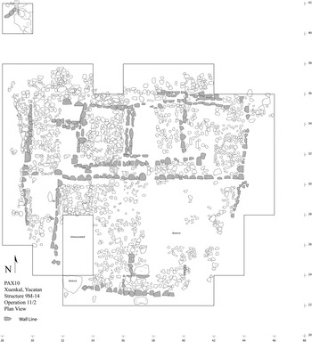
Structure 9M-14 is a modest multiroom residential structure with a terrace located inside the urban core just west of 9M-40 (Figure 3). The building was selected for investigation due to its proximity to the defensive fortification that surrounds the site core. A nearby off-mound test pit produced a mix of ceramic material dating to the Early Classic and Late Classic periods. Since 9M-14 was included inside the fortification and showed no evidence of having been dismantled for the construction of the fortification, one may surmise that the structure was still in use at the time of construction of the defensive walls. Defensive constructions are notoriously difficult to date with precision; however, the span of occupation of 9M-14 affords an indirect method with which to date the defensive constructions at Xuenkal.
Plan view of the excavation area of Structure 9M-14. Each tick on the grids represents 2 m. Wall lines of the structure and terrace are shown in gray.

The building was constructed on a slight natural rise and consisted of a single 8 × 12 m room block that was divided into three rooms of equal size facing south onto a low terrace of similar dimensions that created a level surface over the bedrock knoll (Figure 4). The exterior walls of the building consisted of two to three courses of roughly hewn limestone blocks, while the interior wall contained a single course still in situ. The size and construction of the walls demonstrate that the building had a perishable roof. Although preservation was poor, pieces of the stucco floor were preserved in some areas. During a later construction episode, a bench was added along the western flank of the building. The bench also faced to the south. The bench consisted of four Puuc-style columnette stones still in situ, with an additional three stones found near the western edge of the structure and terrace. Contemporary with the construction of the bench was a 2 m expansion of the western terrace edge.
View to the east showing the rooms of Structure 9M-14.

A total of 2,317 sherds were recovered from excavations of 9M-14 of which 55% were Cehpech, 16% Sotuta, 7% Late Preclassic Nabanche, 7% Early Classic Cochuah, and 17% unidentified (Vallejo Reference Vallejo Caliz2011:67). The Cehpech material consisted of Muna Group (72%, mostly Muna Slates), Chum Group (15%, exclusively Yokat Striated), Ticul Thin Slate (12.5%), and Teabo Red (<1%). No fine paste wares such as Fine Orange were recovered.
Twelve pieces of obsidian were recovered in total, of which 11 were from the Chayal source and one from Pachuca (Geoffrey Braswell, personal communication 2007). Additionally, four pieces of chert and one fragment of green stone were recovered. A dedicatory cache from beneath one room contained a necklace made of 84 bone and shell beads.
10M-27
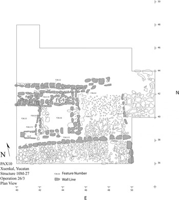
Structure 10M-27 is a three-room superstructure measuring 16 × 4 m that fronted a large plaza located on the northeastern edge of the largest outlying Cehpech group, located 400 m north of the site core. The residential group was mapped, and three off-mound test pits were excavated around the group in 2006 (Figure 5), and the eastern half of the structure and surrounding area was excavated in 2007 (Stockdell Reference Stockdell2009).
Plan view of the excavated portion of Structure 10M-27. Ticks on the grid units are in 2 m intervals. The excavation grid is oriented 12 degrees east of north, and wall lines are shaded gray.

The group containing Structure 10M-27 appears to have been abruptly abandoned, suggesting that its final occupation dates to the period of Xuenkal's Late Classic collapse. Since outlying Late Classic elite residential groups at other sites may have been occupied throughout the period of decline of local political authority, the abandonment of structures such 10M-27 may postdate the abandonment of the central administrative complex, offering a potential terminus ante quem for the cessation of local political authority at Xuenkal. Unfortunately a sample of stucco from the structure that was submitted for dating yielded an unreliable radiocarbon date from the seventeenth century.
Evidence from the elevated platform Structure 10M-24 on the west flank of 10M-27's terrace suggests that the abandonment was rather abrupt. The expanded 10 × 15 m platform was left unfinished at the time of abandonment. The core of the platform consisted of large unmodified boulder fill that had been laid across the platform to a depth of approximately 1.5 m, concealing in places earlier constructions. The final preparation of a platform floor—the addition of small pebble fill known locally as chich stones—was lacking, as was any evidence for plaster. Such unfinished Cehpech construction episodes have been documented at Kiuic in the Puuc region as evidence for a rapid abandonment (Parker et al. Reference Parker, Simms and Bey2011; Simms Reference Simms2011).
Excavation of Structure 10M-27 revealed that it was a three-room residential structure constructed in a single construction episode with cut stones along the front façade and more rustic boulders along the rear. The structure is of similar proportions and construction to 9M-14 but is distinguished by its cut stone façade along the front of the structure and along the edge of the patio. Each excavated room of 10M-27 also contained a bench running along the rear wall. Although a maximum of only two courses of stones were still intact, excavations revealed the presence of a stucco floor, a bench along the rear wall, and a paved patio floor across the front of the building.
Artifacts from 10M-27 are limited. The ceramic material includes 1,579 sherds, of which 75% are Cehpech, 2% are Sotuta, 2% are Cochuah, <1% are Nabanche (Vallejo Reference Vallejo Caliz2011:67), and 21% were too eroded to be identified. Of the Cehpech, 65% are from the Muna Group (predominantly Muna Slate), 33% are from the Chum Group, and <2% are Ticul Thin Slate. As with 9M-14, no fine paste wares were recovered. Other artifacts include four pieces of chert and five obsidian prismatic blade fragments. A concentration of worked marine shell, six pieces in all, was encountered at the base of the wall dividing the center and eastern rooms.
9M-136
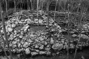
A single off-mound test pit placed just to the west of Structure 9M-136 produced one of the best samples of pure Cehpech material (Figure 6). Based on this identification, the building was selected for extensive excavation in 2006. The building consisted of a low mound located approximately 50 m south of the sole cenote at the site. The structure is located in the midst of a nineteenth-century hacienda and was highly impacted by its construction. The pre-Hispanic superstructure had been almost completely dismantled by the construction of an apsidal historic house sited on the summit of the substructure. Although the superstructure had been largely demolished, the substructure was largely intact and sealed beneath a historic earthen floor. The floor of the historic structure was placed directly over a pre-Hispanic stucco floor, with only a few scars of the superstructure preserved. The result was that the historic construction largely demolished the pre-Hispanic superstructure but enveloped and preserved the substructure with minimal impact.
Plan view of excavated area of Structure 9M-136. The grid is marked in 2 m intervals and oriented to magnetic north. The wall lines of the pre-Hispanic structure are shown in grey and the historic construction overlaying this building has been omitted.

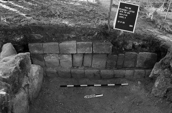
Excavations revealed that the pre-Hispanic Structure 9M-136 was built in two construction episodes. The original building 9M-136 sub-1 was composed of a square structure measuring approximately 6 m on each side. The substructure stood less than 1 m above ground surface and was constructed on top of a natural bedrock rise. Only a small segment of the original west wall was encountered during excavation, bearing a Puuc-style inset design including columnettes (Figure 7). Carbonized kernels of maize deposited on the floor at the base of this wall as either a dedicatory act associated with new construction or as a midden deposit yielded a 2 sigma date of a.d. 685–935 (Sample AA86761). Although the east wall was largely dismantled by historic constructions, it also appears to date to the original construction episode. The area to the west of the western edge of the substructure was leveled into a stucco-floored terrace measuring 6 m wide and 10 m long. The terrace was raised just high enough above the bedrock rise to form a level surface.
Western façade of 9M-136 sub-1. Carbonized maize grains were recovered from floor area near arrow (Radiocarbon Sample AA86761).

The second construction episode essentially doubled the size of the substructure when the previously constructed terrace was walled in and filled so that the substructure subsumed the terrace area. The new walls were strengthened by a construction wall consisting of large roughly shaped limestone boulders running east to west inside the southern third of the building. The construction wall abutted the exterior of the western edge of the 9M-136-sub substructure and extended westward to just inside the west wall of the final construction episode. Primary access to the substructure likely shifted the long axis of the building from the west to the north. This modification may reflect the increasing status derived for the residents from the building's close proximity to the only water source.
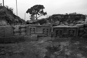
The façade of the final construction episode was best preserved along its northern face, where all three courses were preserved in places. The building bore Puuc-style columnettes with a more baroque design than the previous version (Figure 8). The building was further elaborated with a false mosaic design in the center of the structure along the north wall.
Detail showing false mosaic façade along the center axis of the north wall of the substructure of 9M-136. View to the south.

Ceramic analysis demonstrates that both construction episodes as well as deposits of discarded material are associated almost exclusively with Cehpech sphere ceramics. Of the 6,262 pre-Hispanic sherds recovered, over 70% were Cehpech, primarily Muna Slates, 10% were Sotuta, 3% were Early Classic Cochuah, and 2% were Postclassic Hocaba. A total of 34 sherds of Fine Orange and 1 sherd of Fine Gray were recovered. Eight fragments of chert were recovered as were four obsidian blade fragments.
The building also contained an exceptionally rich series of burials, each one containing Cehpech ceramics, dominated by Muna Slate (Tiesler et al. Reference Tiesler, Cucina, Manahan, Price, Ardren and Burton2010). Imported wares include Fine Gray and Fine Orange cylindrical vases. Based upon the burial vessel assemblages and the associated radiocarbon date, Structure 9M-136 may have been founded by a.d. 700 to 750 and was likely abandoned early in the tenth century at the latest.
TERMINAL CLASSIC TRANSFORMATION
Terminal Classic settlement patterns at the site reveal new arrangements and new architectural forms. These freestanding elevated platforms were located exclusively inside the 1 km2 nucleus of the site interspersed around monumental constructions. These architectural units appear to be primarily single-component constructions, although some encased earlier abandoned structures. One Terminal Classic Sotuta group excavated in 2007 held the remains of a partially dismantled structure associated with Cehpech ceramics within the construction fill. Off-mound test excavations have identified at least 18 examples of such platforms scattered across the site center. While Sotuta ceramics are ubiquitous in the site center, their range is limited to within approximately 500 m of the site center; they are notably absent beyond the immediate center of Xuenkal.
Concurrent with these constructions are modifications of existing buildings and new small-scale constructions erected within patios. The perishable constructions associated with a low defensive wall ringing the plaza of the Palace, 9M-40, are one such example. Other examples include the reuse and extensive modification of low range structures in the compound around 9M-80, southwest of the Palace. Previously open areas were blocked off and filled with a warren of rooms. Near the largest pyramid, 10M-62, occupants built a series of small square rooms on the surface of the temple's southern basal terrace. Midden deposits from this locale contained dense concentrations of Sotuta material, primarily Dzitas Slates, Tohil Plumbate, green obsidian from the Pachuca source, and three spindle whorls.
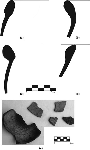
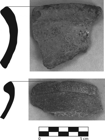
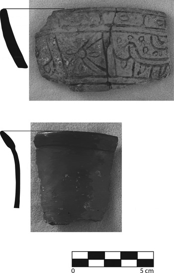
We trace the introduction of this new architectural form to the zenith of Chichen's power and influence in the region. The sampled platforms contain the greatest concentration of Sotuta ceramic materials from both living surfaces and construction fill contexts. Xuenkal's Sotuta Complex is comparable to that defined by Smith (Reference Smith1971) from Mayapan and Chichen Itza. Three groups are most common. Dzitas Slate Wares, most commonly types Dzitas Slate (Figure 9a–d) and Balantun Black-on-slate, but also Chacmay Incised grater bowls (Figure 9e); and Sisal Coarse Wares (Figure 10) are recovered in equal amounts, with the Dzibiac Group (encompassing Brainerd's [1958] Chichen Red Ware) present in frequencies that rarely exceed 15%. Finally, imports include Fine Orange Ware from Balancan, Silho Groups (Figure 11a), and Tohil Plumbate (Figure 11b), and together form between 0.5 and 2% of the assemblage.
(a–d) Rim profiles of Dzitas Slate Basin forms; (e) Dzitas-type Chacmay Incised grater bowls.

Sisal Group rims and profiles. Types Sisal Unslipped (top) and Piste Striated (bottom) are shown.

Balancan Fine Orange type Caribe Incised bowl (top) and Tohil Plumbate globular jar rim fragment.

Although Xuenkal possesses Sotuta phase architectural platforms contemporaneous with Chichen Itza, at the same time it lacks any of the specialized architecture such as colonnaded halls and gallery-patio structures (Ruppert Reference Ruppert1943, Reference Ruppert, Reed and King1950) that is so closely (and almost exclusively) associated with the urban center. While these forms have been reported from Isla Cerritos and other coastal sites (Andrews Reference Andrews1978, Reference Andrews1986; Andrews and Gallareta Negrón Reference Andrews and Negrón1986), their absence may suggest that Chichen's political role at Xuenkal was less direct than at other locales.
8M-1
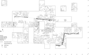
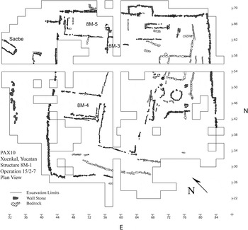
Structure 8M-1 consists of a massive rectangular basal platform measuring approximately 55 × 50 m and standing 3.5m tall with its main axis facing northwest toward the cenote (Figure 12). The platform was expanded through a series of construction episodes until it completely encompassed the natural bedrock rise which provided its base. The surface of the platform held a series of superstructures. In 2005 an off-mound test pit excavated off the northern edge of the platform produced a ceramic sample of almost pure Sotuta material down to bedrock.
Plan view of the final version of Structure 8M-1 showing excavated area. The grid ticks are at 2 m intervals and the grid is oriented 45° east of north. The terminus of the sacbe is seen in the upper left corner of the map. Wall lines of the platform and superstructures are marked in gray.

The construction sequence includes at least four discrete construction episodes, indicating both a horizontal and vertical expansion of the platform as more and larger superstructures were added to the platform. 8M-1 sub-3, the initial construction phase, was identified from the traces of two walls found in the northeast quadrant of the platform. The north wall ran east-west for a total of 4 m before disappearing abruptly. The east wall of 8M-1 sub-3 extended approximately 6 m, but we were unable to identify the northeast corner where the two walls should have joined. The walls were built directly over bedrock. The earliest architecture is distinguished from later constructions by the construction style. A limited sample of ceramic material excavated from contexts associated with this wall is predominantly Cehpech (with some earlier material) with no Sotuta material present. Likely associated with this earliest platform was a trace of a superstructure wall, consisting of three cut stones still in situ on the surface of 8M-1 sub-3. This suggests that the earliest construction may have been associated with the nearby temple 8M-7, which an off-mound test pit found was associated almost exclusively with Cehpech material. It is possible that one radiocarbon date from the assay may in fact date this earliest construction. The sample (AA86759) consisted of carbonized wood and ash recovered near the base of the east wall of 8M-1 sub-1. Most of the 2 sigma range of a.d. 665–968 falls within the expected Cehpech chronology although the surrounding ceramics were all Sotuta.
The relationship between this earliest construction episode and subsequent constructions is unclear; however, the evidence for continuity is much greater between all subsequent construction episodes. Based upon this limited evidence, we suggest that 8M-1 sub-3 represented the remains of a Cehpech structure that was largely demolished and encased inside the Sotuta constructions of 8M-1 sub-2 through the final version of 8M-1 and associated superstructures.
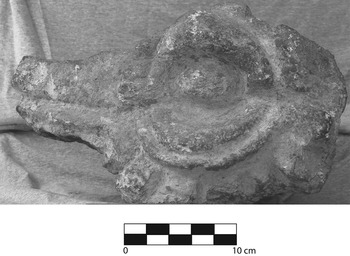
The next construction episode, 8M-1 sub-2, contains an extension approximately 6 m to the north and an even greater extent to the south. The platform took a roughly rectangular form that measured approximately 20 × 30 m. Inside the construction fill to the north of the north wall a broken carved stone sculpture of the head of a serpent was recovered (Figure 13). The stone had been laid to rest directly against the exterior of the north wall along the basal course. The orientation of 8M-1 sub-2 (30° east of north) and the size of the expansion suggest that the platform was constructed as a raised terrace in front of the superstructure 8M-2, to the south, which also shared the same orientation. Fill from 8M-1 sub-2 is overwhelmingly associated with Sotuta ceramic material, and buried middens from sub-2 and later contexts are associated exclusively with Sotuta material. The third construction episode, 8M-1 sub-1, consisted of an extension between 4 m and 6 m along each side. The orientation of the platform shifted at this time to 45° east of north, which was carried over to the final construction episode as well. The north wall of this construction episode measured 26 m long.
Carved stone serpent head recovered from the fill of Structure 8M-1.

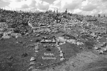
The fourth and final construction episode of 8M-1 consisted of an extension primarily to the east and west, with minimal expansion to the north and south walls. The north wall corresponded to the previous construction episode with a series of outsets, presumably to support the newly constructed superstructures placed along the north edge of the platform. The east wall was extended by 4 m, and the west wall was extended by 8 m. A large staircase was constructed rising up the steep slope of a natural bedrock incline. The staircase was poorly preserved and heavily impacted by adjacent colonial constructions, but it originally measured at least 14 m wide and 6 m deep. The faced stones of the steps had been almost completely removed; only one segment of the stairs was found in situ. Two radiocarbon assays (AA86756 and AA86757) from a midden buried under the collapse of the balustrade and west wall of 8M-1 place the platform's use between calibrated a.d. 970 and 1150 (2 sigmas, rounded). The terminus of the only known sacbe from Xuenkal was found near the preserved steps and the northwest corner of the platform (Figure 14). The sacbe consisted of two parallel lines, each composed of a single course of stones and measuring 2.2 m wide, and extended due north from the platform, where another section of it was identified approximately 50 m away. The modest sacbe is consistent in terms of scale and construction techniques to the myriad of smaller sacbes constructed contemporaneously at Chichen Itza that joined similar residential platforms to the center (Cobos Reference Cobos2003, Reference Cobos, Kowalski and Kristan-Graham2007).
Terminus of Sacbe 1 at the base of 8M-1 (foreground, center). The basal course of the outset balustrade is visible above the sacbe terminus and slightly to the left. View to the southeast.

8M-1 Superstructures
The identification and excavation of seven different superstructures suggests a very dynamic period of construction activity during the final construction episode. All excavated contexts across the surface of 8M-1 were associated with Sotuta or later material.
The superstructure 8M-2 was the tallest and seemingly primary structure of the group. It was centered along the southern limit of the platform and faced north. The structure was rectangular, although the northern and eastern sides had been largely dismantled at some point in the past. The base of the structure consisted of well-cut blocks that contained a mosaic of inverted grecas. Where it was preserved on the west and south walls, the design element could be seen to repeat twice along each wall.
Just to the west of 8M-2 and sharing its orientation was Structure 8M-4, a C-shaped structure measuring 12 m long by 6 m wide. C-shaped structures have been reported from many sites in northern Yucatan (Shaw and Johnstone Reference Shaw and Johnstone2006) and are also found around the Peten lakes area (Rice and Rice Reference Rice, Rice, Chase and Rice1985). As Bey et al. (Reference Bey, Hanson and Ringle1997) have reported, C-shaped structures in the northern lowlands are always associated with the ultimate constructions during a period that they have labeled “post-monumental.” Stratigraphically, 8M-4 was built later than 8M-2, although it is unclear how much time separated the structures. The eastern half of Structure 8M-4 and the western half of 8M-2 were under construction at the time of abandonment. A series of unmodified large limestone cobbles had been neatly stacked across this area, filling in the narrow passageway that separated the two structures. The construction was apparently unfinished, as no surface was encountered. Ceramics from this area included many Hocaba and Tases types, including Mama Red, suggesting that this final construction could have been a Postclassic period addition. However other common Postclassic ceramic types such as Chen Mul Modeled, associated with the censers of Mayapan, are virtually absent. Only a single sherd of Chen Mul was recovered from the entire operation. The radiocarbon sample AA86760, taken from a charred fragment of a post hole to the east of 8M-4, may date this occupation. The 2 sigma range is a.d. 1312–1444.
The north side of the platform was covered by 8M-5, a long superstructure that spanned most of the length of the platform. The structure was divided into two rooms: 132a on the west and 132b on the east. Both rooms had benches inside, with the bench in 132a facing east along the west wall of the room and the bench in 132b facing south centered along the north wall. Very little architecture was preserved in both rooms, as presumably most of the faced stone had been stripped off for use in nearby colonial constructions.
In between Structure 8M-5 and the front of 8M-2 to the south was Structure 8M-3, a small square building measuring approximately 6 m on a side. Although the building was also poorly preserved, a concentration of composite censer fragments with appliqué cones on their exterior were recovered, as were fragments of ladle censers. Given the location of the building in the center of the courtyard and its size and dimensions, we suggest that it likely served as the base for a shrine in the plaza.
8M-1 Materials
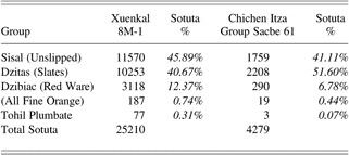
In total 42,641 sherds were recovered from the excavation of 8M-1. The material consists of 60% Sotuta, 4% Cehpech, <1% Postclassic Hocaba and Tases, <1% Early Classic Cochuah, and 34% unidentified. The Sotuta ceramics consist of 46% Sisal Group, 40% Dzitas Group, and 12% Dzibiac Group. A total of 77 sherds of Tohil Plumbate, 10 sherds of Balancan Group Fine Orange, and 40 Silho Group Fine Orange were recovered. An additional 137 sherds of Fine Orange unidentified group were also present.
In contrast to the limited nonceramic artifacts found at Cehpech associated structures, lithic production, shellworking, food preparation, and weaving activities can be discerned from the materials recovered at 8M-1. A total of 519 pieces of obsidian, including prismatic blades, bifacial projectile points fashioned from prismatic blades, and flakes were found widely distributed in the platform excavations, although no evidence for production was found. A total of 818 chert artifacts were recovered, including 5 cores, 93 unifaces, 31 bifaces, and 60 projectile points, as well as debitage from all stages of tool manufacture and resharpening. Analyses of the 292 pieces of marine shell from 8M-1 show that shell was worked into decorative objects. Raw materials, debitage from all stages of manufacture, and finished products were found (Alonso et al. Reference Alonso, Manahan, Castro, Arellano, Valentín and Ardren2013.). Ground stone tools in excess of domestic food requirements (n = 19) were found within construction fill and exterior living areas to the east of 8M-2 and south of 8M-5B, possibly indicating productive activities other than cooking or food production beyond household requirements. Finally, an impressive number of ceramic spindle whorls (n = 17) were recovered from the structure, suggesting that weaving was an important activity undertaken at this platform (Ardren et al. Reference Ardren, Manahan, Wesp and Alonso2010).
CHICHEN ITZA: POLITICAL ECONOMY AND REGIONAL HIERARCHIES
Chichen Itza has been characterized as the most expansionist, mercantile, and politically integrated ancient Maya polity (Andrews Reference Andrews1983, Reference Andrews1990; Andrews et al. Reference Andrews, Andrews and Castellanos2003; Andrews and Robles Castellanos Reference Andrews, Castellanos, Chase and Rice1985; Brainerd Reference Brainerd1958; Cobos Reference Cobos, Kowalski and Kristan-Graham2007; Freidel Reference Freidel, Sabloff and Andrews1986; Morley Reference Morley1940; Ringle et al. Reference Ringle, Negrón and Bey1998; Schele and Freidel Reference Schele and Freidel1990; Schele and Mathews Reference Schele and Mathews1998; Tozzer Reference Tozzer1930, Reference Tozzer1957; Wren and Schmidt Reference Wren, Schmidt and Culbert1991). The polity's expansion into the region between central Yucatan and the north coast (including Xuenkal and environs) likely was underway by a.d. 900 if not earlier (Andrews et al. Reference Andrews, Negrón and Palma1989; Andrews et al. Reference Andrews, Andrews and Castellanos2003). Isla Cerritos has long been identified as the primary port on the north coast (Andrews et al. Reference Andrews, Negrón, Robles, Cobos and Cervera1988; Andrews and Gallareta Negrón Reference Andrews and Negrón1986; Gallareta Negrón Reference Gallareta Negrón1998), and Chichen Itza's influence extended across the eastern and western coasts of the peninsula through an elaborate coastal trading network (Andrews Reference Andrews1978, Reference Andrews1986, Reference Andrews1990; Andrews and Robles Castellanos Reference Andrews, Castellanos, Chase and Rice1985; Freidel and Sabloff Reference Freidel and Sabloff1984; Kepecs et al. Reference Kepecs, Feinman and Boucher1994; Robles Castellanos and Andrews Reference Robles Castellanos, Andrews, Sabloff and Andrews1986). At Chichen Itza's core, the diversity, quality, and quantity of luxury goods recovered from the Sacred Cenote (Coggins Reference Coggins1992; Proskouriakoff Reference Proskouriakoff1974; Tozzer Reference Tozzer1957) as well as the immense civic architecture, including the largest ballcourt in Mesoamerica and the Gran Nivelación, testify to a highly integrated political economy that functioned on a scale unprecedented in the Maya world. State-sponsored iconography makes clear the intertwined themes of military conquest and extraction of tribute (Baudez and Lastsanopoulos Reference Baudez and Latsanopoulos2010; Morris, Morris and Charlot Reference Morris, Morris and Charlot1931; Ringle Reference Ringle2009). The political economy likely extended beyond prestige-enhancing luxury goods.
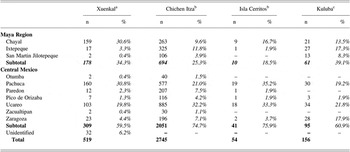
Braswell and Glascock have suggested that a market economy operated at Chichen based upon differential household access to obsidian (Braswell Reference Braswell, Garraty and Stark2010; Braswell and Glascock Reference Braswell, Glascock and Glascock2002, see also Stanton and Gallareta Negrón Reference Stanton and Negrón2001). While access to Mexican obsidian from sources such as Ucareo and Pachuca were initially bounded within the confines of Chichen Itza, by approximately a.d. 900 a “fully commercialized, interregional, and open market economy” was in place (Braswell Reference Braswell, Garraty and Stark2010:137). Changes in the amounts and sources of obsidian at Xuenkal between Cehpech and Sotuta contexts suggest that the later inhabitants were participating in this open market economy. In Cehpech contexts, materials come almost exclusively from the El Chayal source, and access was extremely limited. Obsidian from Sotuta constructions comes from the same Mexican sources found at Chichen Itza although in frequencies that vary (Table 2).
Comparison of quantities and frequencies of Ceramic Groups from 8M-1 at Xuenkal and Group Sacbe 61 from Chichen Itza. Frequencies relative to total amount of Sotuta material

Data from Chichen Itza adapted from Cobos (Reference Cobos2003:400).
We suggest that Xuenkal household economic organization underwent a dramatic reorganization of production strategies during the Terminal Classic period. These changes occurred as part of a strategy toward integration into an incipient regional economy or, alternatively, as a strategy to meet new tribute demands imposed by Chichen Itza's political economy. Shifts in household strategies were accompanied with equally dramatic changes in regional political organization. Judging from the limited data from Xuenkal's Palace, 9M-40, the local administrative hierarchy collapsed before the Sotuta households were constructed. At approximately the same time, the local network of production, distribution, and consumption of Cehpech ceramics ceased to exist. The exclusive association of Terminal Classic households with Sotuta sphere ceramics may have been less the result of factors such as prestige, identity, ethnicity, or class (Chase and Chase Reference Chase, Chase, Demarest, Rice and Rice2004) than a reflection of what was available and being produced in a tightly bounded economy. The impressive quantity of Sotuta material available to Terminal Classic households reflects both the relative prosperity of the Xuenkal households and the low cost of the pottery itself, suggesting that pottery distribution may have occurred through an administered market economy, as has been proposed for the distribution of obsidian (Braswell and Glascock Reference Braswell, Glascock and Glascock2002).
Tellingly, frequencies of Sotuta Group ceramics from excavations at a household along the sacbe extending northwest from Chichen Itza (Cobos Reference Cobos2003) are comparable to those from Xuenkal, some 45 km away (Table 3). The striking similarities in ceramic frequencies between these two distant households may suggest that both participated in the same centralized economic and political network. The only difference was that Sacbe Group 61 was situated on the local periphery of Chichen Itza, 1.2 km from the urban core, while 8M-1 was located on the regional periphery of the polity. If some vestige of Xuenkal's local political authority was maintained, the data suggest that its impact upon household economies was minimal. This may have resulted in a phenomenon that at first glance appears to be a paradox: a decline in both local administrative authority and demography, but an increase in household economic integration. The impetus for this integration lay not in the hands of local leadership, but instead in the interests of Chichen Itza. Tempering the view towards direct political control over Xuenkal, however, is the limited size of the Terminal Classic occupation in contrast to the Late Classic expansion, the lack of evidence for a military conquest at Xuenkal, and the absence of any specialized ritual or civic architecture such as gallery-patio structures or colonnaded halls that may have signaled a more direct state presence.
Obsidian sources represented in assemblages from Structure 8M-1 at Xuenkal as compared to published frequencies from contemporary contexts at Chichen Itza, Isla Cerritos, and Kuluba

aAnalyzed by Alonso based on previous work by Braswell
bData derived from Braswell and Glascock (Reference Braswell, Glascock and Glascock2002:39)
cGuzmán Ortiz Rejón (Reference Guzmán Ortiz Rejón2007)
In the case of Xuenkal, it appears that local households were integrated into a new regional political and economic network with few alternatives. Although many inhabitants may have simply voted with their feet, the remaining Terminal Classic households adapted to changing circumstances through increased economic productivity and exploitation of new regional exchange networks. Ultimately, Chichen Itza's involvement in the affairs of Xuenkal households may have been largely limited to the realm of economy rather than direct political control. While the documented shifts in household production may have been spurred by outside pressures, the changes seen were not implemented as mandates passively received by Xuenkal's residents, but were the result of decisions made by people adapting to a rapidly fluctuating regional network.
CONCLUSION
The investigation of Xuenkal has provided new information on the tumultuous transition from the Late Classic to Terminal Classic periods in the northern lowlands. Household excavations demonstrate marked changes between households associated with Late-Terminal Classic Cehpech sphere ceramics and those associated with Terminal Classic Sotuta sphere ceramics. Besides changes in ceramics, these differences include changes in architecture and use of space, changes in access to obsidian and stone tool production, and perhaps most significantly, changes in strategies of domestic production.
Late Classic Xuenkal domestic economies display a focus on household subsistence with limited access to imported goods such as Fine Orange pottery and obsidian. The co-occurrence of limited amounts of Sotuta material in otherwise Cehpech contexts may mark the initial emergence of Chichen Itza's political economy. The expansion of Chichen Itza as a regional power coincided with a decline of local administrative authority early in the tenth century. The archaeological correlates for this decline are seen within the Palace, where mapping, surface collecting, and off-mound test excavations concur that the Palace ceased to function at the same time as the local networks for the production and distribution of Cehpech ceramics collapsed. Chichen Itza's role in the demise of Xuenkal's political authority, if any, remains unclear, and one need not invoke conquest to explain this decline as polities across the peninsula underwent similar processes at this moment in time. Modest new constructions and defensive modifications inside the Palace patio, both of which were associated with Sotuta ceramics, testify to a period of political uncertainty and limited population size.
In the wake of this destabilizing force, new households were constructed with new domestic economies. New construction appears to be limited to an area of approximately 1 km2 of the site core, as Sotuta ceramics are absent from the rural zone around Xuenkal (Stockton Reference Stockton2009). These new households demonstrate different patterns of spatial organization and new architectural styles. The most radical differences are noted in terms of the domestic economy. Household production of chert, shell, and textiles, among other goods, greatly increased in association with Sotuta ceramics. Access to ceramic vessels (likely produced within Chichen Itza) greatly increased, as did access to exotic central Mexican obsidian. Households increased production well beyond local needs, particularly of textiles and shell ornaments. This may have been a way to exploit the new economic network or a means to meet newly imposed tribute burdens, or perhaps both. The success of this strategy is testified by both the series of expansions of the 8M-1 platform and the volume of ceramics discarded within a short period of time. The result was that during the Terminal Classic period, households were more tightly integrated within a political economy centered 45 km away than Late Classic households ever were to the local administration.
At the same time that these new households prospered, other architectural forms such as colonnaded halls and gallery-patio groups that are closely associated with Chichen Itza administrative elites were not constructed at Xuenkal, despite their presence at Isla Cerritos. We argue that the strong influence of Chichen Itza's market economy over Terminal Classic Xuenkal without the presence of specialized administrative or ritual architecture indicates that the direct physical administration of Xuenkal by Chichen's political authority was minimal. While Xuenkal's inhabitants were tightly bound to Chichen Itza's economy, at the same time they experienced a degree of autonomy relative to other communities. Xuenkal's location along the main route from the coastal port of Isla Cerritos to Chichen Itza meant that inhabitants were likely in regular contact with passing agents of the state, whether they were merchants, warriors, or political elite. This close contact no doubt facilitated exchange with the distant polity and may have spurred a period of relative prosperity for the inhabitants. At the same time, any direct challenge to the new political economic network would surely have been promptly eliminated. In this dynamic situation, Xuenkal households forged a path that afforded them access to the wealth of the nearby state seemingly without surrendering complete local autonomy.
The expansion of Chichen Itza across the Cupul region shows both the fluidity of state political and economic power and the resilience of local households as they were integrated into the emergent polity. The diversity of strategies of domination and the ways in which local communities responded demonstrate that Chichen Itza did not dominate the peninsula in a monolithic fashion. The effects of an expanding polity varied among regions, communities, and perhaps even from one household to the next, as stakeholders negotiated relations with their counterparts in the city. We argue that in order to best understand the dynamics of state expansion, one must include multiple perspectives and acknowledge the role and impact of local communities.
RESUMEN
Mientras que la actuales ideas sobre la historia sociopolítica de las tierras bajas mayas del norte reconocen que el florecimiento de Chichen Itza como una polity mayor tuvo una escala sin precedente, y ocurrió durante el periodo clásico terminal en vez de en el posclásico tardío, las ramificaciones del traslape cronológico entre el surgimiento de Chichen Itza y la caída de las unidades políticas vecinas ha permanecido como un tema inexplorado. El centro antiguo de Xuenkal, localizado en la región Cupul a unos 45 Km al noreste de Chichen Itza es uno de los pocos sitios del interior de la península que contiene un número substancial y discreto de ocupaciones Cehpech y Sotuta. El proyecto arqueológico Xuenkal (PAX) se inició en el 2004 para dilucidar el papel de Chichen Itza en la historia de la región Cupul, así como la importancia que las elites locales de Xuenkal pudieron tener en la negociación de la dinámica política regional. Como ocurrió en muchos sitios cercanos, al parecer la historia de ocupación de Xuenkal tuvo su cúspide durante la esfera cerámica Cehpech del periodo clásico tardío-terminal. Sin embargo, a diferencia de otros sitios vecinos asociados con esta esfera cerámica, como Ek'Balam o Yaxuna, Xuenkal contiene un asentamiento Sotuta importante concentrado en el centro del sitio durante el clásico terminal. Estas poblaciones se adaptaron al paulatino desarrollo de la economía regional a través del incremento de la producción doméstica, a diferencia de los grupos residenciales del clásico tardío. Mientras que los contextos domésticos Sotuta están fuertemente integrados con la economía regional de Chichen Itza, la evidencia de un control directo del estado no es totalmente evidente. En este artículo sugerimos que la relación entre Chichen Itza y las comunidades de su región fue más dinámica de lo que modelos teóricos actuales argumentan, y que la trama política de Chichen Itza a todo lo ancho de la península debe ser considerada a través de contextos locales con variaciones en los ámbitos doméstico, de comunidad y de región.
ACKNOWLEDGMENTS
Research was supported with funding from the National Science Foundation (#BCS0852233 and #OISE-0502306), FAMSI (#05064), Kent State University Research Council, and the Offices of the Provost and Dean of the College of Arts and Sciences of the University of Miami. Permission for work at Xuenkal was granted by the Instituto Nacional de Antropología e Historia, Mexico. We gratefully acknowledge the contributions of Geoff Braswell, whose unpublished analysis and sourcing of the obsidian from Xuenkal in 2005 and 2007 formed the basis of Alonso's analysis. We thank Art Joyce, Lisa Lucero, and three anonymous reviewers for their helpful comments. Finally, we wish to thank Justin Lowry, Eric Stockdell, Trent Stockton, and Daniel Vallejo, among others, for their participation in the Project.