The recent surge in intensive radiocarbon dating programs in conjunction with Bayesian chronological modeling is allowing for the substantive reconsideration of Indigenous North American histories. Archaeologists are now able to effectively construct high-resolution, high-precision absolute chronologies, often at the scale of decades or better. As materially based chronologies highlight major transitions in artifacts over the long term, they often present considerable barriers to the study of more subtle processes of continuation. We argue that the study of the varied Indigenous-colonizer encounters and entanglements that unfolded across North America can benefit substantively from the use of high-resolution absolute chronologies. Here, we center chronology as a critical component in the characterization of the narratives we construct. In doing so, absolute chronologies become central to unraveling the complexities of Indigenous-colonizer dynamics in the southeastern United States.
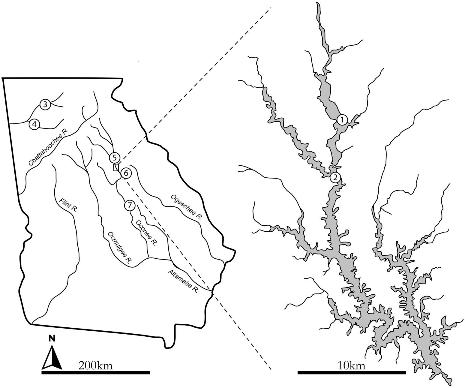
Here, we reconsider the some of the first encounters between Muskogean-speaking communities of the interior southeastern United States and Spanish colonizers—specifically, Hernando de Soto and his entrada of 1539. Although processes of depopulation and social transformation were undoubtedly set in motion by this and earlier colonial encounters, the temporality and heterogeneous rhythms of sixteenth- and seventeenth-century Indigenous histories across the broader southeastern United States remain unclear. Through the integration of AMS radiocarbon dates and archaeological data from the earthen platform mound at the Dyar site (9GE5) in the Oconee Valley of central Georgia (Figure 1), we present a case of Indigenous resilience and endurance in the immediate aftermath of initial European contact. We focus on enduring traditions related to the use of platform mounds and provide evidence that these practices persisted for up to 130 years beyond initial contact with de Soto. Such refined chronologies of mound-building traditions shed new light on the endurance and cessation of these practices and provide greater context for historical accounts of eighteenth-century mound building.
The location of the Wallace Reservoir and archaeological sites mentioned in the text: (1) Dyar (9GE5); (2) Joe Bell (9MG28); (3) Little Egypt (9MU102); (4) Etowah (9BR1); (5) Scull Shoals (9GE4); (6) Shouldernbone (9HK1); (7) Shinholser (9BL1).

To this end, we first describe the social landscape of the Oconee River valley during the mid-sixteenth century. Next, we use a Bayesian interpretive framework to analyze new AMS radiocarbon dates along with older conventional radiocarbon dates from the Dyar site in the Oconee Valley. We use these data to explore the timing and temporality of mound construction, use, and abandonment at Dyar. Our study highlights a case of enduring Indigenous traditions, and, given the lack of Spanish artifacts uncovered at the site, the potential immateriality of colonial encounters. In many ways, our interpretations depart from previous material-based arguments of the site. Throughout, we supplement our archaeological narratives with perspectives generously offered by representatives of the Muscogee (Creek) Nation—descendants of those who lived in the Oconee Valley, encountered de Soto and his men, and constructed the mound at Dyar.
Toward Absolute Temporalities
The use of absolute chronologies moves us beyond tendencies to establish temporal boxes that emphasize material discontinuity and that can contribute to Indigenous erasure or the disenfranchisement of modern-day descendant communities from their deep ancestral histories (Creese and Walder Reference Creese, Walder, Walder and Yann2018; Panich and Schneider Reference Panich and Schneider2019). Indeed, the assumptions that we build into our archaeological chronologies can substantively affect our narratives (Lulewicz Reference Lulewicz2018a; Panich and Schneider Reference Panich and Schneider2019). As an example, recent work in California has demonstrated how the use of culture-historic frameworks rooted in materially based chronologies can contribute to both the mass obfuscation of continuity and Indigenous erasure, distorting Indigenous histories of European colonialism (Panich and Schneider Reference Panich and Schneider2019).
Materially based chronologies, although useful at broad spatial and temporal scales, can often obscure important details needed for elucidating histories of Indigenous-colonizer interactions. For example, the distribution, presence, absence, or abundance of ceramics, lithics, or European trade goods is affected by not only time but a myriad of factors. These include manufacture, use-life, exchange relations, adoption of technologies, and durability. Consequently, a thorough analysis of such materials and their social contexts is, of course, critical for understanding the complexities of Indigenous-colonizer interactions. Although absolute dating and Bayesian chronological modeling are not replacements for these lines of material evidence, they can serve to complement and substantively contextualize such evidence.
Difficulties in the use of materially based chronologies become even more pronounced in Indigenous contexts. When using a materially based temporal framework, it becomes challenging to rectify observations that contradict typological frameworks, such as the persistence of Indigenous traditions, or more generally, the poor fit between established material breaks and historical continuity (Nassaney Reference Nassaney, Walder and Yann2018). In this sense, we must “embrace anomalous data” and cases that challenge long-standing typological frameworks and narratives (Nassaney Reference Nassaney, Walder and Yann2018:55). Fortunately, contemporary studies of Indigenous-colonizer dynamics across the southeastern United States—and North America more broadly—are now emphasizing both historical contingency at a local scale and histories that are writ large across regions (e.g., Beck Reference Beck2013; Beck et al. Reference Beck, Rodning and Moore2016, Reference Beck, Newsom, Rodning and Moore2017; Boudreaux et al. Reference Boudreaux, Meyers and Johnson2020; Cobb Reference Cobb2019; Ethridge and Shuck-Hall Reference Ethridge and Shuck-Hall2009; Hofman and Keehnen Reference Hofman and Keehnen2019; Legg et al. Reference Legg, Blanton, Cobb, Smith, Lieb and Boudreaux2019; Manning and Hart Reference Manning and Hart2019; Thompson et al. Reference Thompson, Roberts Thompson and Worth2018; Thompson, Marquardt et al. Reference Thompson, Marquardt, Walker, Roberts Thompson and Newsom2019; Walder and Yann Reference Walder, Yann, Walder and Yann2018).
Regarding chronology and temporality, archaeologists studying the dynamics of the European colonization of North America have generally relied on historical texts, ceramic phases, glass trade beads, European metals, and even paleoethnobotanical evidence for European cultigens (e.g., peaches, watermelon). Scholars, in turn, relied on these markers for the construction of temporal frameworks and the interpretation of Indigenous-colonizer encounters. As we noted above, however, such markers can obscure the temporal placement of a site, either elongating or compressing time given both the context and the presence or absence of such artifacts.
American archaeologists have indeed embraced new advances in Bayesian chronological modeling, establishing absolute chronologies for sites, regions, events, and trends independently of, or formally in conjunction with, materially established chronologies (e.g., Abel et al. Reference Abel, Vavrasek and Hart2019; Brown et al. Reference Brown, Gilmour, Solimano and Ames2019; Cobb et al. Reference Cobb, Krus and Steadman2015; Hart and Brumbach Reference Hart and Brumbach2005; Krus and Cobb Reference Krus and Cobb2018; Lulewicz Reference Lulewicz2019a; Marquardt et al. Reference Marquardt, Krus and Thompson2020; Miller Reference Miller2018; Ritchison Reference Ritchison2018; Thompson and Krus Reference Thompson and Krus2018; Thulman Reference Thulman2019). Such efforts, however, remain difficult for exploring European colonization. For the critical timespan encompassing the European settlement of North America (sixteenth through eighteenth centuries), calibrated radiocarbon dates intercept multiple points along the radiocarbon calibration curve and exhibit wide ranges of error spread across hundreds of years, foiling attempts to resolve time via radiocarbon determinations. Bayesian chronological modeling, however, combined with laboratory advances in radiocarbon dating (e.g., AMS dating), is allowing archaeologists to successfully use radiocarbon dating as an effective method of establishing high-resolution chronological frameworks for this critical time period (e.g., Ames and Brown Reference Ames and Brown2019; Hill et al. Reference Hill, Beck, Lengyel, Trabert and Adair2018; Manning and Hart Reference Manning and Hart2019; Manning et al. Reference Manning, Birch, Conger, Dee, Griggs, Hadden, Hogg, Ramsey, Sanft, Steier and Wild2018, Reference Manning, Birch, Conger, Dee, Griggs and Hadden2019; Thompson, Jefferies, and Moore Reference Thompson, Jefferies and Moore2019). Here, we contribute to this growing body of work by presenting a case of Indigenous endurance and resilience that has long been obfuscated by the difficulties of absolute dating and the uncritical reliance on materially based chronologies and typologies.
The Oconee Valley, AD 1540–1670
On March 3, 1540, the de Soto entrada of approximately 600 men left the Apalachee town of Anhaica, from the Florida panhandle, and headed northeast into the interior of what would become the southeastern United States (Hudson et al. Reference Hudson, Smith and DePratter1984:67). Just shy of one month later, on March 31, de Soto and his men reached the town of Ichisi, near present-day Macon, Georgia (Figure 1). After erecting a cross there, they moved east into the Oconee River valley, where they encountered the first chiefdom of the Oconee Valley around April 4 (Hudson et al. Reference Hudson, Smith and DePratter1984:70) The Oconee Valley was home to a dense Indigenous network of polities distributed throughout the basin of the Oconee River (Williams Reference Williams, Tesser and Hudson1994). Between April 5 and April 13, de Soto followed the Oconee River northward, visiting the towns and the primary political capitals of Altamaha, Ocute, and Cofaqui. At Altamaha and Ocute, which are thought to be the sites of Shinholser (9BL1) and Shoulderbone (9HK1), respectively (Figure 1), he erected two more crosses (Hudson et al. Reference Hudson, Smith and DePratter1984:70–71). From the time they left Ichisi to their departure of Ocute, de Soto and his men spent 11 days in the Oconee Valley, and just 45 days moving through the greater surrounding region from their wintering camps among the Apalachee to their arrival at the Savannah River on April 17, 1540.
Archaeologists regard de Soto's expedition through the southeastern United States between 1539 and 1542 as the watershed moment and catalyst for the mass depopulation and traditional collapse of Native American societies across eastern North America (e.g., Milner Reference Milner1980; Smith Reference Smith1987). It is well established that the century following de Soto's expedition was characterized by death and disease among Native American populations of the southeastern United States (Milner Reference Milner1980; Smith Reference Smith1987, Reference Smith1994) and the greater Americas (Denevan Reference Denevan1992; Jorelman Reference Jorelman1982; Ramenofsky Reference Ramenofsky1987; Zubrow Reference Zubrow1990). The archaeological record indicates widespread depopulation at both local and continental scales, including for the Oconee Valley during postcontact times (Kowalewski and Hatch Reference Kowalewski and Hatch1991). Dominant archaeological narratives propose that such extreme depopulation worked to destabilize Indigenous societies (e.g., Smith Reference Smith1994). For the Oconee Valley, evidence from settlement patterns, material discontinuities, and ethnohistoric records has been used to track subsequent collapse. Such discontinuities include the dismantling of complex political networks, the abandonment of earthen platform mounds, and the movement into dispersed homesteads throughout the valley (Kowalewski and Hatch Reference Kowalewski and Hatch1991; Smith Reference Smith1992, Reference Smith1994).
In 1540, when de Soto and his campaign blazed through, the Oconee Valley was organized as a network of chieftaincies with the capital located at Ocute (the Shoulderbone site). It was neighbored to the west by the Ocmulgee River valley and the province of Ichisi, a similarly organized hierarchy of chiefdoms (Hudson et al. Reference Hudson, Smith and DePratter1984). To the north were a few smaller polities and to the east was the Savannah River valley, which was abandoned at least 100 years earlier by approximately AD 1450 (Anderson et al. Reference Anderson, Stahle and Cleavland1995; Ritchison Reference Ritchison2018, Reference Ritchison2019). Far to the northwest, stretching across the southernmost reaches of the Appalachians—through southeastern Tennessee, northwestern Georgia, and northeastern Alabama—was the Coosa chiefdom, the most extensive and powerful political entity in the interior southeast at Spanish arrival (Hudson et al. Reference Hudson, Smith, Hally, Polhemus and DePratter1985; Smith Reference Smith2000). Indeed, oral histories can be used to highlight the endurance of these relationships and connect the ethnohistorically known Coosa chiefdom to contemporary practices. Hickory Ground Tribal Town, a Creek town that was located in Alabama in the seventeenth century and ancestral to Coosa, was the last capital of the Muscogee (Creek) Nation before removal (Piker Reference Piker2006). Indeed, the Hickory Ground ceremonial ground in Oklahoma continues to be active today, with their chief donning the title of Coosa Mekko (or Chief Coosa; Historic and Cultural Preservation Department–Muscogee [Creek] Nation, personal communication 2019).
Settlement in the Oconee Valley has a long history stretching back into the Paleoindian period. From the Middle Woodland period (ca. AD 100–600), genealogical links begin to emerge to practices that characterized the later Mississippian period, especially in the form of earthen mound construction that would have been observed by the Spanish. By 1540, major mound centers included the Shoulderbone and Shinholser sites—which have been correlated with the towns of Ocute and Altamaha visited by de Soto—as well as the Scull Shoals (9GE4), Little River (9MG46), and Dyar sites, the last of which was located near the ethnohistorically recorded town of Cofaqui. Each remained important political seats of power subsumed under obligations to the most powerful chief at Ocute. At this same time, the landscape of the Oconee Valley was also densely populated with over 800 small Mississippian period sites, including small hamlets and individual farmsteads (Williams Reference Williams, Tesser and Hudson1994). An unusual aspect of the Oconee settlement pattern was that it consisted primarily of small dispersed farmsteads. The only possible village sites confirmed in the region are those at the mounds themselves, and even these were small (Kowalewski and Hatch Reference Kowalewski and Hatch1991).
By 1550, these mound centers began losing their populations, and by 1580, according to dominant narratives, they were abandoned entirely, with all populations living in dispersed farmsteads (Williams Reference Williams, Tesser and Hudson1994). Although this has been interpreted as a complete political collapse, the population across the valley continued to increase until at least 1600 (Kowalewski and Hatch Reference Kowalewski and Hatch1991; Williams Reference Williams, Tesser and Hudson1994). In fact, at one large site, Joe Bell (9MG28), a large circular structure of 15 m in diameter has been interpreted as evidence for lower-level political integration centered on farmsteads, which are separated by approximately 500 m and clustered around spring heads (Williams Reference Williams, Tesser and Hudson1994). More recently, it has been interpreted as evidence for a ceremonial square ground that would have served similar purposes of dispersed community integration (Williams Reference Williams2016). Despite the densely settled landscape and intensive archaeological survey (discussed below), virtually no archaeological evidence for de Soto has yet to be recovered (Smith Reference Smith1992). This is a pattern similar to other areas visited by de Soto (e.g., Dalton-Carriger Reference Dalton-Carriger2016), although Spanish materials associated with later encounters have indeed been recovered.
By 1630, the population of the Oconee Valley began to decline, possibly rapidly, due to the spread of disease and probably resulting from the emergence of the Indian slave trade, both of which were introduced through an increased European presence across the southeast. The Westo Indians seemed to have moved into the southeast by the 1650s from the northeast, and soon after, they began raiding Indigenous towns for slaves for the newly arrived Virginians (Bowne Reference Bowne2005). In the fall of 1659, it was reported that a combined force of Westo Indians and Virginians had been seen 80 leagues north of Apalachee, in central Georgia (Aranguiz y Cotes Reference Cotes and Alonso de1659; Bowne Reference Bowne2005:75). The news itself was likely provided by refugees of the province of Tama, located at the geologic fall line of the Oconee River at the Shinholser site (Worth Reference Worth1993, Reference Worth, Tesser and Hudson1994, Reference Worth1995). Although the demographic effects of these slave raids forced many Indigenous people toward Spanish missions to seek protection (Bowne Reference Bowne2005), it is likely that some moved southwest into the Chattahoochee River valley to join the emerging Creek Confederacy, borne out of this shattering landscape (Williams Reference Williams, Tesser and Hudson1994). By 1670, when the English settlement of Charleston was established on the coast of South Carolina, the Oconee Valley had been abandoned.
The Dyar Mound and Wallace Reservoir Excavations
The Wallace Archaeological Project was initiated in 1971 when archaeologists began limited surveys ahead of the construction of the Georgia Power Company's hydroelectric reservoir along the Oconee River in northeast Georgia (Figure 1; Gresham Reference Gresham1987). Now called Lake Oconee, archaeologists from the Department of Anthropology at the University of Georgia were contracted by the Georgia Power Company to conduct an intensive archaeological survey of the proposed reservoir. Initial survey and testing consisted of identifying and evaluating the range of sites present, although most attention was given to identifying well-preserved sites that could potentially yield subsurface archaeological deposits (DePratter Reference DePratter1976, Reference DePratter1983). Although the Wallace Reservoir represents only a small portion of the Oconee Valley, the project produced a full-coverage dataset and facilitated funding for the intensive excavation of major mound centers, whose exploration without this funding and resources would likely not have been feasible.
Of the 292 sites identified through the survey, 22 were deemed eligible for large-scale excavation (DePratter Reference DePratter1976). In addition, part of the funds were reallocated from excavation to take advantage of the fact that forestland had been cleared from across the entire 53 km2 (or 17,000 acres) basin (Gresham Reference Gresham1987). This part of the project was known as the Wallace Mitigation Survey and remains one of the few large-scale, full-coverage surveys in the southeastern United States. In addition to a full-coverage surface survey, across the reservoir basin, four 1.5 km wide pedestrian transects were conducted in cultivated areas adjacent to the reservoir, and four 0.75 km wide transects within the reservoir basin were surveyed via backhoe clearing. In total, 3,108 sites have been recorded across the Wallace Reservoir survey area, representing a full-coverage sample of the greater Oconee Valley.
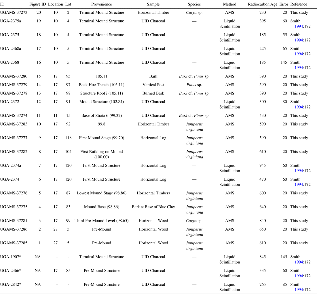
Some known sites were initially tested using a backhoe to excavate 10 m long, 1 m wide, and 3 m deep trenches at 80 m intervals along alluvial features, such as levees and terraces (Gresham Reference Gresham1987; Ledbetter Reference Ledbetter1978). Additionally, many known sites were also tested via close-interval, systematic shovel-test surveys (DePratter Reference DePratter1976). One of these sites initially tested via shovel tests was the Dyar mound and village site, which was subsequently excavated in 1977 and 1978 (Smith Reference Smith1994). When excavations began, the earthen mound at Dyar—the focus of the present article—stood 10.3 m tall and 52 m in diameter at its base (Smith Reference Smith1994:4). Marvin Smith, who undertook the excavations of the mound, which has since been inundated by water, produced the most extensive stratigraphic profiling of an earthen mound in the state of Georgia, and it is among one of the most well documented across the southeastern United States (Figures 2 and 3). The work at Dyar was also the initial basis for a refined ceramic chronology for the Oconee Valley (Smith Reference Smith1983), which continues to be employed today as the primary chronological referent for sites across the region.
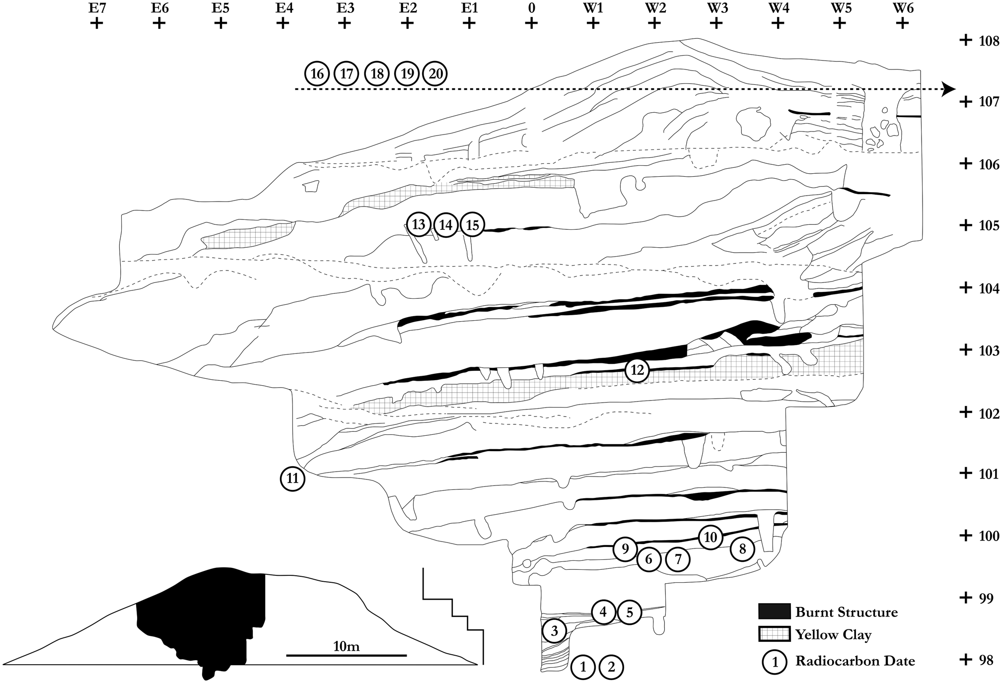
Profile of the Dyar mound adapted from Smith (Reference Smith1994). Radiocarbon dates are numbered and correspond to the plot in Figure 5 and the dates in Tables 1 and 2. Vertical and horizontal units are in meters. The top of the mound and the locations of dates 16–20 are depicted in detail in Figure 3.

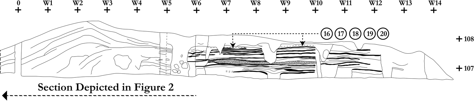
Southern profile of the top of the Dyar mound adapted from Smith (Reference Smith1994). Dark layers indicate the burnt structure sequence for the southwestern, enclosed structure, with the modeled hearth and clean floors depicted in Figure 4. Stippled layers are red fired soil. Dates 16–20 are from the last structure in this sequence.

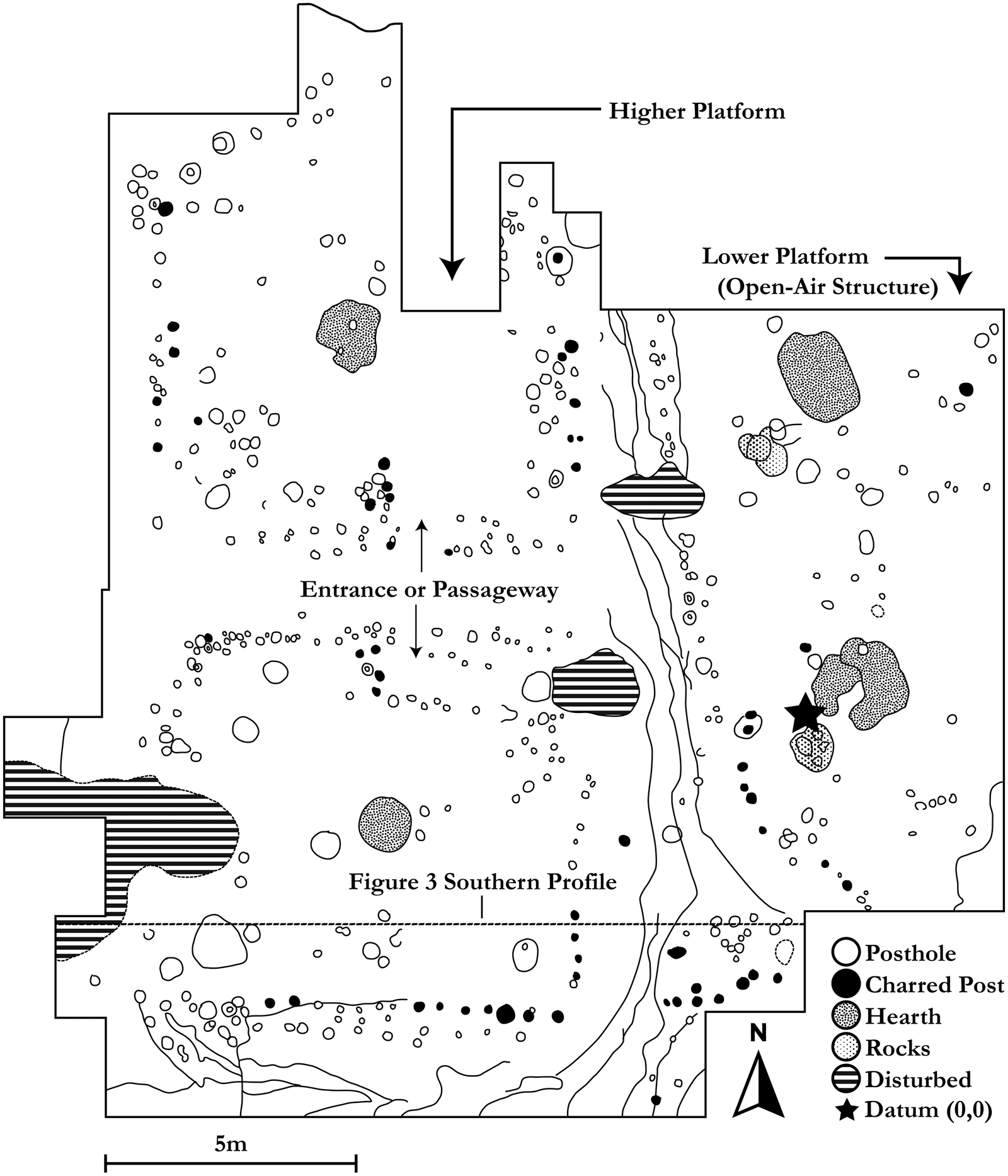
Plan view of the terminal mound-top structures adapted from Smith (Reference Smith1994). The rebuilding sequence for the southwestern structure is depicted in the southern profile drawing in Figure 3. The modeled clay hearth and Ilex pollen are from the southwestern structure. The open-air structure filled with domestic midden is the eastern structure on the lower platform.


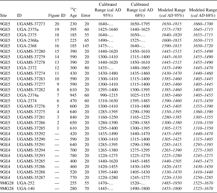
Calibrated and Modeled Ranges for Radiometric Dates from the Dyar (9GE5) Mound Profile and the Scull Shoals (9GE4) and Joe Bell (9MG28) Sites.

In all, 14 stages of mound construction were identified and recorded along with a terminal mound stage that included the repeated construction of 18 mound-top structures, each burned and successively rebuilt (Figure 2). The excavation of the terminal structure, in particular, has yielded unprecedented context for studying Mississippian tradition at the time of Spanish contact, given that this series of structures has yielded modeled clay hearths, pollen from Ilex vomitoria (otherwise known as yaupon holly, which was used to make the ceremonial “black drink”), the continued reuse of large red cedar posts through the span of rebuilding, and a dual-platform layout complete with both open and enclosed structures utilized for different purposes (Smith Reference Smith1994; Figure 4). Based on contemporary understandings of ceremonial rites and organization by the Muscogee (Creek) Nation, one side was likely used for medicine/ceremonies, whereas the other was used for council—or one side for the mekko (primary chief) and the other for the heneha (second chief), with each side corresponding with a summer side and a winter side (Historic and Cultural Preservation Department–Muscogee [Creek] Nation, personal communication 2019). Aside from these terminal stages, the overall construction sequence provides insight into changing temporalities of mound construction practices and potentially highlights shifting use of the mound through time. This is evident from an abrupt shift in construction techniques within the mound profile, as discussed below.
From throughout and below the mound, 20 radiocarbon dates are available (Tables 1 and 2). Of the seven extant radiocarbon determinations obtained from both the mound and village contexts at Dyar, only two were deemed reasonable in the original reporting (Smith Reference Smith1994:171). The primary factor in the rejection of dates was the incompatibility of the calibrated radiocarbon determinations with preconceived understandings of material chronologies. These include both Indigenous ceramic traditions and the complete absence of Spanish materials except for a single Spanish glass bead—found on the eroded surface of the site after reservoir construction—that dates to after approximately AD 1580, 40 years after encounters with de Soto (Smith Reference Smith1994:176). Due to these interpretations, Dyar has since been regarded as having been abandoned immediately after de Soto arrived in the Oconee Valley, by approximately AD 1560, based on the acceptance of one, and the rejection of three, radiocarbon dates from the terminal mound structure (Smith Reference Smith1994). It remains perplexing, however, why such an interpretation would be offered for the Dyar site alone, given that it remains accepted that the entire valley was densely occupied at the time of the colonial encounter, even in the absence of Spanish materials from the Oconee Province as a whole (Kowalewski and Hatch Reference Kowalewski and Hatch1991; Smith Reference Smith1992; Williams Reference Williams, Tesser and Hudson1994). There remains a problematic disjuncture between—or conflation of—materiality, chronology, and history.
In the rest of the article, we report a series of new AMS determinations, interpret new and existing determinations within an archaeologically derived Bayesian interpretive framework, and reevaluate the timing and temporality of occupation at Dyar and across the Oconee Valley after AD 1540. In doing so, we reconceptualize the materiality of colonial encounters in the Indigenous southeast, provide an example of Bayesian chronological modeling as a decolonizing practice, and further add to the growing body of literature challenging the dominant grand narratives of Indigenous collapse across North America.
The Timing and Temporality of Platform Mound Use at Dyar
To critically reassess the absolute timing of the occupation and mound use at Dyar, 20 radiocarbon determinations (Tables 1 and 2) were evaluated within a Bayesian interpretive framework. Seven of these are existing dates, whereas 13 are newly run AMS determinations. The seven extant dates were all determined via liquid scintillation, and they were primarily derived from unidentified charcoal. Of the 13 new dates, all are determined via accelerator mass spectrometry (AMS), and all are derived from intact wooden logs/posts (and in some cases, bark) that were recovered during excavations and that could be identified to the species. Species for newly dated samples include hickory, pine, and red cedar. All dates included in the Bayesian model could be located to the exact depth within the mound profile (Figures 2 and 3). As such, the Bayesian model is based solely on the associations and relationships of the mound contexts from which dates were recovered. Five of the modeled dates come directly from the terminal structure atop the mound (Figure 4), whereas the rest span its use-life, including pre-mound contexts.
Multiple temporalities of mound construction and use are apparent in the stratigraphic profile (Figure 2). The bottom half of the roughly 10 m profile is characterized by six stages of approximately regular thickness with alternating layers of fill and burnt structures. Midway up the profile, a new pattern emerges of alternating thin and thick stages. Marking the beginning of this change is a thick yellow clay cap constructed above the first six stages of the mound. It is also at this stage that the mound top is altered to have two separate mound-top platforms of slightly different heights, each with its own structure (Figure 4). This pattern of alternating thin and thick layers is roughly 2 m thick (from ca. 102–104 m; see Figure 2). Above 104 m, this pattern yields to only thick layers for approximately 2 m. At approximately 106 m, we see the beginning of a set of repeatedly rebuilt dual mound-top structures (Figure 3). Between 106.3 m and 107.6 m, 18 structures are repeatedly burned and rebuilt. Even before this sequence, however, there are a number of hearths that precede them stretching down to approximately 104.2 m.
The structures on the western platform of the mound top have meticulously clean floors (Smith Reference Smith1994:36), a characteristic that endures today and continues to be associated with the presence of a sacred fire (Historic and Cultural Preservation Department–Muscogee [Creek] Nation, personal communication 2019). The eastern structure has two hearths enclosed by an open-air cover with an abundance of midden refuse, possibly of domestic activity or feasting (Smith Reference Smith1994:36). The hearths from the western structures have elaborately modeled clay rims, and palynological work of hearth contents indicates the presence of Ilex vomitoria (Smith Reference Smith1994). Together, these features have been interpreted to be representative of a “sacred fire,” as known from historic documents. The clean floors, modeled clay hearth, and evidence for the preparation and consumption of black drink are all practices that have long histories in the southeast going back to the beginnings of Mississippian fluorescence across the region and possibly earlier (see Sherwood et al. Reference Sherwood, Blitz and Downs2013). Of the two western structures on the higher platform, the northwestern structure was rebuilt at least six times, whereas the southwestern structure was rebuilt at least 18 times. Just as these structures were repeatedly built in the very same spot, retaining the locations of major posts and the hearth, contemporary Muscogee (Creek) Nation tribal members (especially men) rebuild arbors in the ceremonial ground yearly in preparation for the Green Corn Ceremony. At the same time, the willow brush from the top is always replaced, and major support poles are often reused (Historic and Cultural Preservation Department–Muscogee [Creek] Nation, personal communication 2019). This is consistent with the probable reuse of large cedar posts on the top of the mound at Dyar.
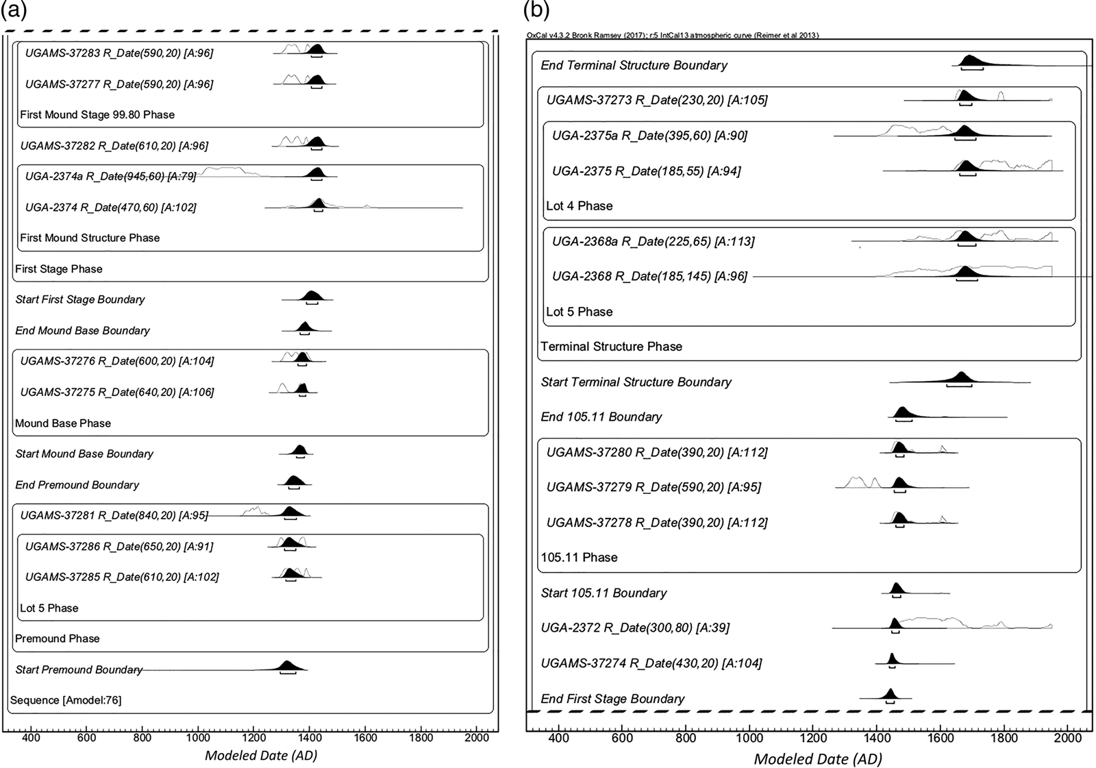
Eleven radiocarbon dates come from mound contexts below the yellow clay cap that marks a change in construction practices from layers of regular thickness and burnt structures to layers of alternating thin and thick layers. One date comes from a burnt structure situated atop the yellow clay cap. Three dates come from approximately 105 m, just before the transition to the dual mound-top platforms. The last five dates all come from the terminal structure, the last in the 18-structure sequence of rebuilding. Using a simple sequence model (Bronk Ramsey Reference Bronk Ramsey2009a), dates were ordered by their associations with mound construction stages, calibrated via the IntCal13 calibration curve (Reimer et al. Reference Reimer, Bard, Bayliss, Warren Beck, Blackwell, Ramsey, Grootes, Guilderson, Haflidason, Hajdas, Hatté, Heaton, Hoffmann, Hogg, Hughen, Felix Kaiser, Kromer, Manning, Niu, Reimer, Richards, Marian Scott, Southon, Staff, Turney and van derPlicht2013), and interpreted within a formal Bayesian model using OxCal v.4.3 (Bronk Ramsey Reference Bronk Ramsey2009a). A charcoal outlier model was applied to all dates derived from unidentified charcoal (Bronk Ramsey Reference Bronk Ramsey2009b). The stratigraphic locations of dates from which the model was built are presented in Figure 2, and the full model code is provided as Supplemental Text 1.
Following Bronk Ramsey's (Reference Bronk Ramsey2009a) acceptance value of 60, the resulting model (Figure 5) had good agreement, with an overall agreement of 78 and a model agreement of 76.1. All modeled dates are presented in italics and at the 68% confidence interval. Dates are presented at the 68% interval due to the long tails of the calibrated dates at this particular section of the calibration curve. The model indicates that the mound began to be built cal AD 1350–1385. The single date at the yellow clay cap transition models to cal AD 1445–1470 (although showing poor agreement with the overall model). This is not to be unexpected given that many of the extant dates have large error ranges, are identified as charcoal outliers, and cross the calibration curves at multiple intercepts. Given the overall model agreement, and the place of this modeled date (UGA-2372) within the mound sequence, we are confident that the modeled date reflects an accurate assessment of the absolute timing of the transition in mound practice. As such, the first half of the mound was probably constructed at most over 120 years and at the minimum 60 years. This transition would have been coeval with the abandonment of the Savannah River valley (Ritchison Reference Ritchison2018, Reference Ritchison2019) and may be evidence of the social and political effects of broader population movements across the region and potentially into the Oconee Valley.

The beginning of the dual-top form and the mound-top structure sequence is modeled to have begun cal AD 1460–1510. The terminal structure in this sequence is modeled to have been used beginning approximately cal AD 1620–1700 and abandoned by cal AD 1665–1735. Using these ranges, the top half of the mound sequence is the result of at least 155 years of rebuilding, or 275 years at most. Although the a priori assumptions built into our model using stratigraphic context has greatly improved the resolution of our radiocarbon dates at an unfortunate plateau in the calibration curve, the effects are not completely mediated. Historical documents indicate that the Oconee Valley was abandoned by AD 1670. Archaeologically, dates from Bell-phase sites—the last ceramic phase in the Oconee Valley sequence—including two dates from the large possible square ground at Joe Bell (9MG28; Tables 2 and 3), are consistent with the historical record that suggests an abandonment by approximately AD 1670. This allows us to estimate the correct date range of the end of the terminal structure on top of the Dyar mound to between roughly AD 1665 and 1670, roughly 125 years after the initial colonial encounter between the Indigenous people of the Oconee Valley and de Soto's entrada.
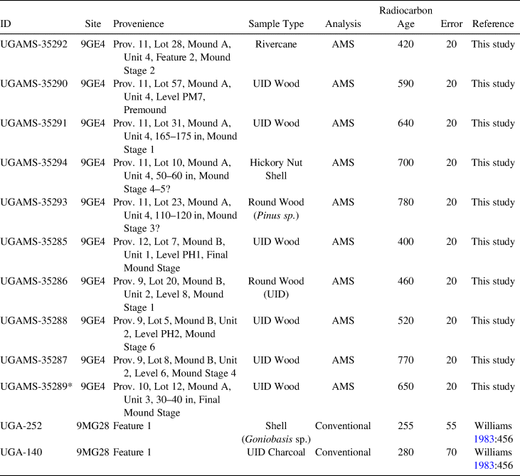
Information on Radiometric Dates from Scull Shoals (9GE4) and Joe Bell (9MG28) Sites.

*Dates not used in the model due to poor provenience information.
To contextualize our analysis at Dyar, nine new AMS determinations were also recorded for two Mississippian period platform mounds at Scull Shoals, located just a few kilometers north of the Dyar mound (Table 2 and 3). Construction began on the mounds at Scull Shoals around cal AD 1210–1265, roughly 85–175 years before construction began on the mound at Dyar. This would place the beginning of the occupation at Scull Shoals coeval with the beginning of the Mississippian fluroescence at Etowah (9BR1) in northwestern Georgia (Lulewicz Reference Lulewicz2018b, Reference Lulewicz2019a, Reference Lulewicz2019b), the largest manifestation of Mississippian tradition and sociopolitics across the region. Conversely, the beginning of Dyar, around cal AD 1350–1385, correlates roughly with the abandonment and collapse of the occupation at Etowah (Lulewicz Reference Lulewicz2018b, Reference Lulewicz2019a). The post-Etowah southern Appalachian landscape coalesced to form the Coosa chiefdom—the largest, most complex, and most powerful political entity across the interior southeast at the time of Spanish contact. Although the mound at Dyar was used until approximately AD 1665, the mounds at Scull Shoals fell out of use around cal AD 1460–1515, at the exact time that populations began to move away from mound centers and into individual farmsteads (Williams Reference Williams, Tesser and Hudson1994), but just before population at the scale of the entire valley began to increase (Kowalewski and Hatch Reference Kowalewski and Hatch1991; Williams Reference Williams, Tesser and Hudson1994). This period, around AD 1400–1450, is the same time that the Coosa chiefdom crystallized, and its capital at Little Egypt (9MU102) was established (Lulewicz Reference Lulewicz2018b). By AD 1600, however, population declined across the Oconee Valley by roughly 40% (Kowalewski and Hatch Reference Kowalewski and Hatch1991). By AD 1650, the population was just 10%–20% of its historical maximum (Kowalewski and Hatch Reference Kowalewski and Hatch1991).
Discussion
The new absolute dates for the use of the mound at Dyar offer a refined perspective on the dynamics of early Indigenous-colonizer encounters and the subsequent effects that these encounters did and did not have on Indigenous traditions. The last defined archaeological phase for the Oconee Valley is the Bell phase, characterized by a settlement pattern of dispersed farmsteads and specific frequencies of ceramic types within assemblages (Williams Reference Williams1983). From the last quarter of the sixteenth century through the first half of the seventeenth century, the landscape remained dominated by hundreds of these homesteads, the largest of which has been recorded at a mere 0.46 ha (Williams Reference Williams1983). Across Bell phase settlements, a minimal number of Spanish beads and peach pits have been recovered, although these do not date to the era of de Soto's expedition. There was very much an opportunity to engage with the Spanish: Worth (Reference Worth1993, Reference Worth, Tesser and Hudson1994) has documented at least five expeditions that reached the middle Oconee River valley from Florida between AD 1597 and 1628. All of these expeditions reported a hostile response from the occupants of the region. The endurance of Mississippian traditions after AD 1540, as evidenced by the longevity of the mound use at Dyar, therefore requires a range of new interpretive frameworks to be considered. Also, our chronology explicitly links the Indigenous peoples in the Oconee Valley at contact to Mississippian traditions, a connection often overlooked by previous research (Historic and Cultural Preservation Department–Muscogee [Creek] Nation, personal communication 2019).
One of the original reasons for rejecting the late dates from the terminal mound structure was the complete absence of Spanish artifacts at the site except for a single blue glass bead of a type dating to after roughly AD 1580, which was found by an amateur archaeologist on the eroded ground surface of the site after reservoir construction (Smith Reference Smith1992:68–69, Reference Smith1994:176). If the new chronological model is accepted, however, long-term Mississippian traditions were continued atop the mound at Dyar until potentially AD 1670, 130 years after de Soto moved through the valley. This would suggest a conscious decision to reject engagement with European materials in these mound-top contexts, or even within the realm of politico-religious practices more broadly. This observation is substantial given the rapid spread of European trade goods across Spanish La Florida throughout the seventeenth century (Waselkov Reference Waselkov1989). Even today, there remains differential adoption of western practices into Muscogee (Creek) tradition. Some contemporary ceremonial grounds do not allow the use of power tools (or in some cases, cell phones, watches, etc.) into the ceremonial ring (Historic and Cultural Preservation Department–Muscogee [Creek] Nation, personal communication 2019). Consequently, even as particular communities differentially adopted European materials, it is likely that they would have remained absent from mound-tops or other ceremonial spaces.
This contrasts with what was seen among the Coosa of southern Appalachia, where initially all of the European artifacts recovered were found in what are thought to be elite graves (Smith Reference Smith1987:119). At the same time, the presence of Spanish artifacts that were spread heterogeneously across a few households indicates a household-level engagement with such materials, independent of broader regional politics and traditions. The fact that the only Spanish goods reported from the Oconee Valley region are a few glass beads—dating to later Spanish expeditions—and peach pits is probably significant considering that Fray Pedro de Chozas took knives, fish hooks, beads, sickles, axes, and chisels in AD 1597 to use as gifts, and such items were valued among the Coosa chiefdoms of southern Appalachia (Worth Reference Worth, Tesser and Hudson1994:117). The post-1540 Indigenous social terrain was one of heterogeneity in networks, motives, interaction, and engagement in diverse socio-material realms. Contributing to this complexity, as recently pointed out, is bias in the interpretation of European materials distributed among Indigenous communities rooted in the overreliance on mortuary assemblages (Legg et al. Reference Legg, Blanton, Cobb, Smith, Lieb and Boudreaux2019), further complicating and problematizing the use of materials as markers of time and temporality.
The new chronology presented here also highlights the necessity for critical reevaluations of Indigenous ceramic chronologies not just for the Oconee Valley but across North America in light of advances in radiocarbon dating and statistical interpretation. Alongside the absence of European artifacts, the lack of particular ceramics from the Dyar mound was also noted as justification for rejecting the persistence of mound use into the seventeenth century. The final ceramic phase for the Oconee Valley has been defined as the Bell phase. Bell phase ceramics differ from earlier ceramic phases in the percentages of techniques of incising, vessel forms, and decorative stamping found within assemblages (Williams Reference Williams1983). There is no single ceramic characteristic that can be used to indicate a Bell phase occupation. Instead, assignment to the Bell phase (ca. AD 1600–1670) is based on assemblage-scale ceramic composition. The absence of a Bell phase occupation at Dyar is based on (1) a lower average number of incised banded pottery, (2) the lack of variability in rim forms seen in previously defined Bell phase assemblages, (3) and the higher (ca. 4%) percentage of complicated stamping (Bell phase assemblages are reported to have less than 1%). While these justifications were initially offered for the absence of a Bell phase component at Dyar, recent reevaluation of the published ceramic data (Smith Reference Smith1994) confirms the presence of fine-incised banded pottery indicative of Bell phase assemblages. In this case, radiocarbon dates were initially rejected based on a preference for a ceramic phase that was bound to temporality and could not be subject to alteration or reevaluation. Given the Bayesian chronology presented here, we suggest that future studies carefully evaluate the assumptions built into ceramic chronologies (e.g., Lulewicz Reference Lulewicz2018a) and that consideration be given to processes beyond time alone that might affect the composition (and heterogeneity) of assemblages across a given region (e.g., interaction, conflict, population movement, resistance, rejection, etc.).
It is important to point out here that the Dyar mound does not represent an isolated holdover after contact with European colonizers. Indeed, there are several examples of platform mounds that were used beyond the sixteenth century. Such examples include the Fatherland site associated with the Natchez in Louisiana, which extends into the eighteenth century (Brown Reference Brown1990); Cofitachequi (the Mulberry site) in South Carolina, which was occupied into the latter part of the seventeenth century (DePratter Reference DePratter, Goodyear and Hanson1989); and a range of towns throughout the Lower Mississippi Valley whose platform mounds may potentially yield construction episodes dating into the seventeenth century (e.g., Kidder Reference Kidder1992). Although these sites are purported to have been occupied well beyond sixteenth-century encounters with European colonizers, the mound at Dyar represents one of the only confirmed examples, via absolute dating, of continued Mississippian traditions related to mound construction and use.
The material landscape of early colonial encounters and entanglements in the Oconee Valley was defined by the endurance and resilience of Indigenous tradition, if not its purposeful intensification. Whether or not this may be the result of a conscious rejection of European material and engagement in new networks, or a product of indifference, remains unclear. What is clear, however, is that Indigenous practices associated with classic Mississippian politico-religious traditions remained intact throughout both the exodus out of mound centers and the coming of Spaniards into these Native worlds. While populations moved into small farmsteads, it is likely that they remained socially and politically integrated through ceremonial precincts that persisted at mound sites such as Dyar and square ground sites such as Joe Bell. We argue that the movement at approximately AD 1550 from villages associated with mounds toward individual farmsteads may have been spurred by heterogeneous Indigenous motives and participation in wider colonial networks. Politically, the movement can be described as one from centralized to decentralized, rather than from intact to collapsed. Indeed, similar arguments have been made to describe the social and political changes of ancestral Chickasaw groups across Alabama before the arrival of European colonizers (e.g., Johnson Reference Johnson and McEwan2000). Consequently, beyond the resilience of religious traditions, the endurance of the mound-top activities at Dyar, combined with the potential council house/square ground uncovered at the Joe Bell site, is evidence for the resiliency of multilevel regional political systems.
Conclusion
With the growing sophistication in radiometric dating and the development and use of Bayesian techniques across the southeast and within historical archaeology (e.g., Thompson and Krus Reference Thompson and Krus2018; Thompson et al. Reference Thompson, Jefferies and Moore2019), high-resolution, high-precision chronologies are allowing us to achieve a more refined understanding of the historical contexts of early colonial encounters. High-resolution absolute chronologies facilitate an appreciation for the temporality and rhythms of these processes, which are often messy, heterogeneous, and not easily fit into essentialized categories of process. The present study certainly serves as justification for renewed dating efforts of curated materials to confirm and explore the endurance of Mississippian traditions, challenge colonial tropes of collapse, critique materially based temporalities, and reconnect these deep Indigenous histories with contemporary descendant communities.
Although the case study presented here works to reframe the historical contexts of early colonial encounters in the Oconee Valley by way of highlighting the longevity and endurance of Indigenous traditions and reformulating narratives of political transformation, it can also be used to highlight the historical development of the study of Indigenous history by as early as the 1700s. The fact that the use of earthen mounds across the southeast, at least in the Oconee Valley at Dyar, continued at least until after the mid-seventeenth century directly questions the motives behind early explanations and interpretations of Indigenous earthen mounds across eastern North America proposed by Euro-Americans. By the mid-1700s, less than 100 years after the abandonment of the mound at Dyar, explanations for the non-Indigenous origins of earthen mounds were being espoused. As less than 100 years would have passed between the Indigenous use of mounds and these explanations, it could be argued that the motives for these myths were purposively racist, denying what would have been a recent collective memory of Indigenous use in favor of explanations that disenfranchised contemporary Indigenous peoples from their histories.
Refined chronological modeling and an appreciation for high-resolution historical frameworks allow us to elucidate Indigenous-colonizer dynamics in ways that were once unfeasible. Such emergent appreciation of time, temporality, and the experience of historical development, along with consultation and collaboration with descendant communities, allows us to contribute to richer interpretations of the European colonization of the Americas and the effects of these encounters on over 14,500 years or more of Indigenous histories.
Acknowledgments
We would like to extend thanks to the Historic and Cultural Preservation Department of the Muscogee (Creek) Nation, especially Raelynn Butler, Turner Hunt, and LeAnne Wendt. We thank them for their invaluably insightful comments and permission to incorporate their extensive commentary into the manuscript. They have greatly enriched the narrative presented here. Funding for radiocarbon dates was provided by the National Forest Service. We also thank Lynn Gamble, Charles Cobb, and two other anonymous reviewers for their valuable and constructive comments, which have greatly improved this manuscript. Marvin Smith provided comments on an early draft for which we are grateful. Thanks to Sergio Quesada for help translating our English abstract to Spanish. Institutional support for this research was provided by the University of Georgia Laboratory of Archaeology and the Center for Applied Isotope Studies.
Data Availability Statement
All data used in this study are presented in text. All OxCal code for the Bayesian models presented are included as Supplemental Text 1.
Supplemental Materials
For supplemental material accompanying this article, visit https://doi.org/10.1017/aaq.2020.40.
Supplemental Text 1. OxCal Code for models presented in article.