BEDFORDSHIRE
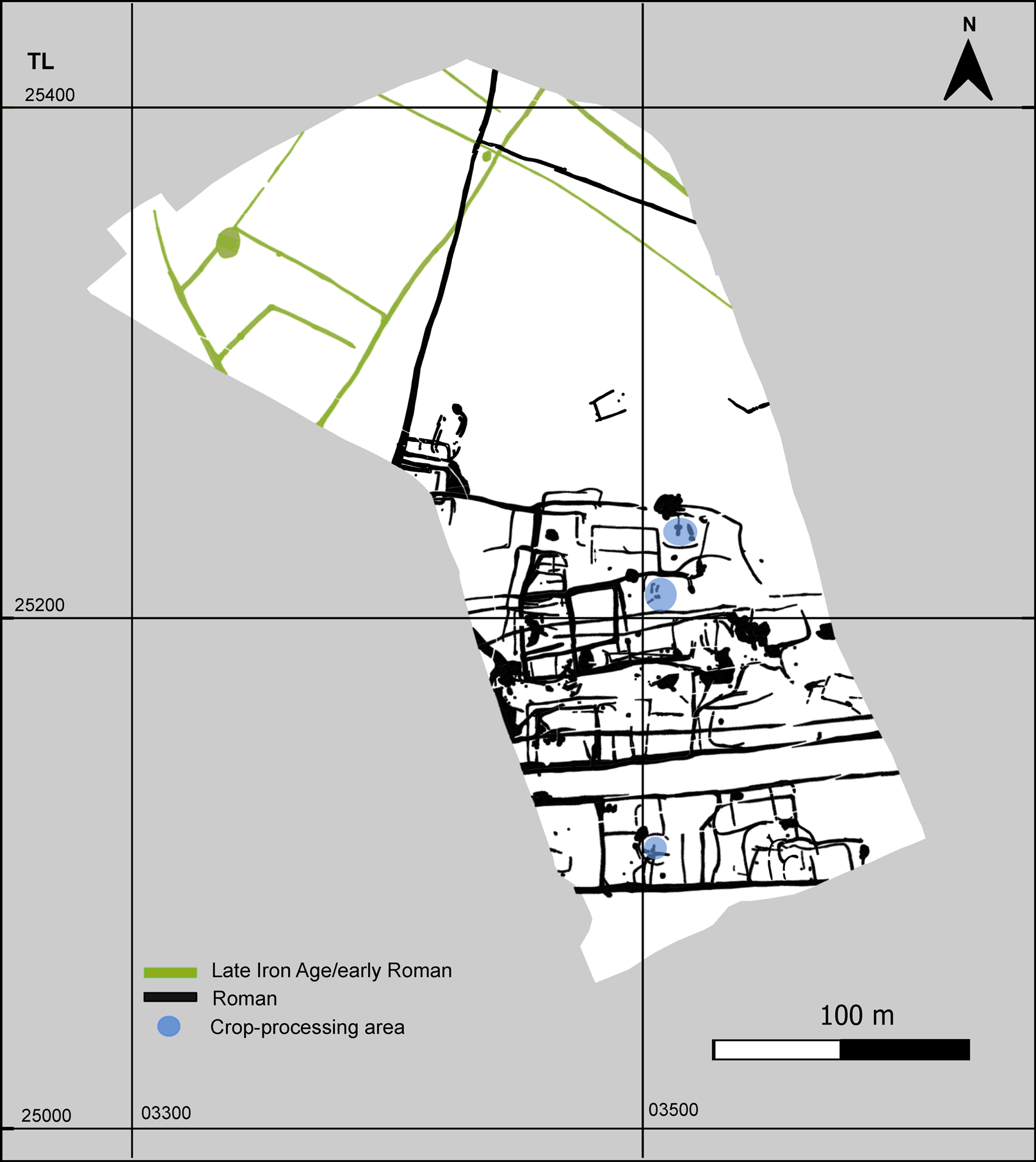
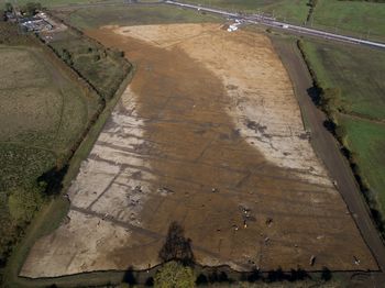
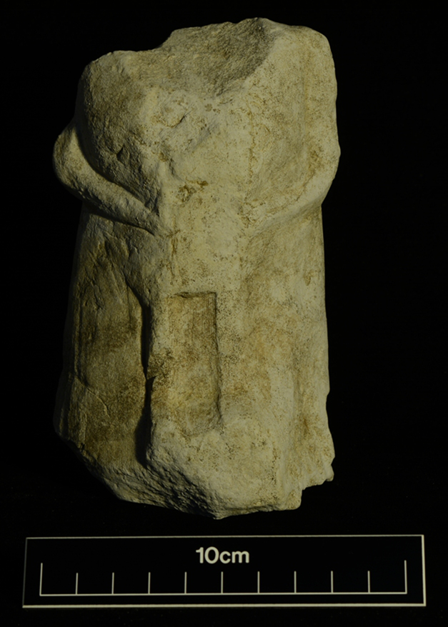
(1) Houghton Regis North 1, Site HRN3206 (TL 0348 2540): excavation covering 5.3 ha was undertaken in advance of a housing development at the north-eastern edge of Houghton Regis.Footnote 71 During the Roman period a farmstead was established along an east–west-aligned trackway with enclosures situated on either side (fig. 8). Some of these enclosures contained evidence of habitation, whilst three contained drying ovens for crop processing. The layout of the c. 2 ha settlement altered over time, but the trackway remained the determining factor in its layout (fig. 9). Evidence for crop processing was identified at three locations within the settlement, each associated with a different type of drying oven: a long hearth, an E-shaped oven and a rectangular type. All were situated within their own enclosures and two were adjacent to water pits. The only buildings positively identified within the settlement were roundhouses, although the layout of some of the smaller enclosures suggests that these may have served as drainage around rectangular buildings. There are some possibly unusual aspects to the artefactual assemblage, including a large number of coins (93), objects with possible military associations (two spearheads, a bolt head and possible apron fittings or strap mounts) and a votive stone carving (fig. 10). The latter is probably of the god Mercury, crudely fashioned from local Totternhoe clunch (height 148 mm; width 89.5 mm; thickness 66 mm, at base). The nature of the carving is suggestive of an amateur sculptor, and the object is thought to be unparalleled in eastern Britain.Footnote 72
Houghton Regis North 1: plan of the Roman farmstead. (Albion Archaeology)

Houghton Regis North 1: aerial view of the Roman settlement. (Albion Archaeology)

Houghton Regis North 1: stone carving. (Photo: Adam Williams; Albion Archaeology)

BUCKINGHAMSHIRE
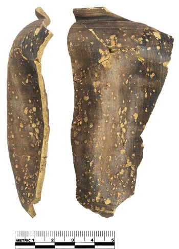
(1) Milton Keynes, (a) Portfields Rise (SP 85287 44042): evaluation in April and May 2018 comprised 14 trenches. Cropmark evidence and the results of a geophysical survey indicated the presence of several rectangular enclosures and a circular enclosure. Excavation revealed a trapezoidal enclosure of Roman date in Area 1. An early Roman farmstead was identified in Area 2, which comprised two closely adjacent rectangular enclosures, the smaller of which contained two probable roundhouses. The enclosures were adjoined at the south-west with an area of smaller enclosures, possibly including further buildings. These were enclosed to the north and east by a ditched boundary. Artefactual evidence from the farmstead includes an iron arrowhead and a rare example of a rough-cast indented beaker in a colour-coated fineware (fig. 11).Footnote 73
Milton Keynes, Portfields Rise: rough-cast indented beaker. (Oxford Archaeology)

ParaInd(b) Wavendon Lodge (SP 93095 38271): an archaeological excavation between May and July 2019 over an area of 0.44 ha revealed a sequence of ditched enclosures dating from the late Iron Age/early Roman period to the late Roman period. Late Iron Age/early Roman features comprised a small ditch, a waterhole and an L-shaped ditch that defined the corner of a field. In the early Roman period, an array of small ditched enclosures was laid out on a different alignment from that of the earlier features. These were probably small paddocks for livestock management and were replaced by three more-substantial ditched enclosures, laid out on the same alignment and recutting some early Roman features. This arrangement was maintained through the middle and late Roman period. A ditch, orientated north–south, probably defined one side of a trackway between the enclosures. A penannular ditch, with an entrance on its eastern side, probably enclosed a circular structure, although no internal features were found. Other features were sparse, but included an oblong oven, possible hearths and several pits. Artefacts include pottery, ceramic building material, fired clay, animal bone, stone, metal and glass artefacts, predominantly of Roman date. Several ditches and pits were sampled for environmental evidence. The site forms the periphery of an Iron Age to Roman settlement lying to the east on the opposite side of Cranfield Road.Footnote 74
CAMBRIDGESHIRE
(1) Balsham, Land at 22 Linton Road (TL 5779 5075): covering an area of c. 1.5 ha, investigations at the site comprised an open area excavation and subsequent watching-brief. The site is located c. 100 m to the north of Roman Worsted Street and close to one of the proposed routes for the Icknield Way. Activity spanned the Roman period and included a possible road with gravelled surface which was identified in the northern part of the site. This was on a broadly north-east–south-west alignment, the same alignment as Worsted Street a few hundred metres to the south, heading towards Roman Cambridge (Duroliponte). The later Roman period saw an intensification of activity with a peak in the fourth century a.d., which included a number of small enclosures, likely delineating working areas, including seven ovens. Several quarry pits dug for the extraction of chalk were also identified, with the evidence demonstrating that the pits were subsequently backfilled with both domestic and industrial waste. The associated finds assemblages include significant small finds and pottery, the former including several items associated with the military, comprising a copper-alloy strap end and horse harness, as well as personal items including jewellery and cosmetic objects. In addition to this is an interesting assemblage of later Roman coins, most of which are of mid-fourth-century date. A layer of Roman buried soil sealed most of the northern and western parts of the site and indicates the gradual abandonment of the Roman settlement probably during the end of the fourth century a.d.Footnote 75
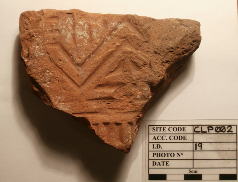
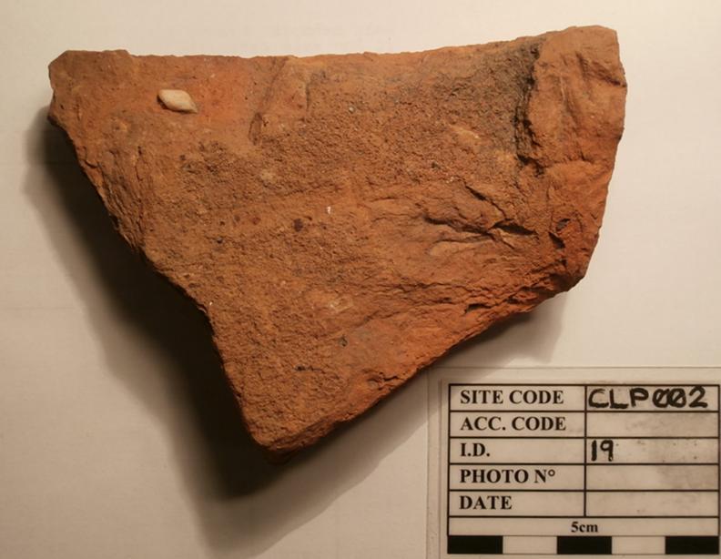
(2) Clopton (TL 30166 48718): Clopton, sometimes Clapton (under which name it is scheduled: no. 1006883), is perhaps best known as the site of the deserted medieval village of the same name. The late John Alexander conducted excavations on the site of the village in the 1960s, and found, in addition to the remains of the parish church, a large Roman boundary ditch. During the autumn seasons of 2018 and 2019 a series of fieldwalking exercises was carried out to the north, west and south of the scheduled area.Footnote 76 Finds spanning the prehistoric to the post-medieval period were found, including Roman pottery and a fragment of relief-patterned tile (figs 12 and 13). The tile fragment, which was produced on a sanded former, is part of a box tile, or voussior, with the remains of a side wall visible on the sanded side. On average, the tile is 22 mm thick, with the side wall being approximately 18 mm thick, but the corner is damaged. The fabric is hard-fired, containing occasional ferrous particles (<1.0 mm) and rare silty pellets. It is an example of I.M. Betts and colleagues’ die 1,Footnote 77 but some of the details are not very sharply defined; perhaps a worn or recut stamp was used. The known distribution of this die covers Totternhoe (Bedfordshire), London, St Albans and Radlett (Hertfordshire), Ashtead and Ewell (Surrey), Broughton (Hampshire) and Chitcombe (East Sussex). In addition, another relief-patterned tile of the same type (die 1) was found during the recent Cambridge Archaeological Unit's excavations in north-west Cambridge.Footnote 78
Clopton: relief-patterned voussoir tile, front. (Cambridge Archaeology Field Group)

Clopton: relief-patterned voussoir tile, back. (Cambridge Archaeology Field Group)

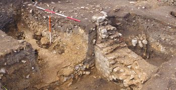
(3) Water Newton (Durobrivae) (TL 121 969): evaluation, comprising geophysical survey and trenches, has been undertaken in advance of a possible larger-scale research project.Footnote 79 This is the first time since the 1820s that significant archaeological fieldwork has been undertaken within the walled area of one of the best-known and largest so-called ‘small towns’ of Roman Britain. The principal aim of the evaluation was to inform and improve our knowledge of the archaeological remains at Durobrivae, and 11 hand-excavated trenches were dug across the interior of the walled area of the town, often targeting anomalies identified by geophysical survey. While most trenches were 5 by 1 m, the trench in the central part of the town measured 10 by 6 m and was targeted on an area where rabbit burrowing is a significant and ongoing threat to the archaeological resource. This trench located the remains of a previously unknown public building in the town's centre with one wall surviving to 2 m in height (fig. 14). This was probably a bath-house, perhaps associated with the adjacent putative mansio; if so, these would be the only baths known within the town. Other buildings investigated included a Romano-Celtic temple provided with a tessellated floor and in use into the early fifth century, a large courtyard building that is thought could have been the town's forum (marketplace), an east–west aligned rectangular building with well-preserved masonry walls and several roadside strip-buildings with domestic or industrial functions. The archaeological deposits encountered in 2019 generally consist of the latest occupation levels of Roman buildings or were derived from their subsequent abandonment and robbing. The evidence suggests that the town was abandoned (and perhaps dismantled) over time in the late Roman and/or immediately post-Roman periods (late fourth and fifth centuries). There is no evidence for wide-scale destruction, and it seems that Durobrivae was not widely reoccupied by Anglo-Saxon inhabitants. The initial post-excavation process has been completed and the results are available in an assessment report.Footnote 80
Water Newton: wall within Trench 1 showing adjacent deposits including floor makeup.

(4) Wicken, land to the rear of 9 to 17 Hawes Lane (TL 56404 71222): evaluation revealed a dense concentration of late Iron Age to early Romano-British archaeological features, including numerous pits and ditches indicative of settlement activity. Further investigation revealed two large Roman boundary ditches along with several smaller rectilinear enclosures which were largely truncated by later features. Finds from these features suggest that nearby settlement activity shifted elsewhere by the mid-second century as the boundary ditches were no longer being maintained by c. a.d. 150.Footnote 81
(5) Wisbech St Mary, land north of 52 Chapelfield Road, Guyhirn (TF 4005 0419): evaluation partly revealed a large pit that produced a substantial quantity of fired-clay briquetage, including forms typical of Romano-British salt production. Together with a wider set of both structural remains to the north and a boundary ditch to the west, which produced further assemblages of briquetage and Roman pottery sherds, these remains strongly suggest Romano-British salt-making activity in the immediate vicinity.Footnote 82
(6) Wyton, land at RAF Wyton, Sawtry Way (TL 28205 75009): trial trench evaluation identified an area of Roman settlement activity, with late Iron Age origins comprising pits and ditches concentrated near the centre of the proposed development site. The site appears to have peaked in the late Iron Age and earlier Roman period, with occupation spanning to the later Roman period, although it is uncertain whether this reflects continuous occupation. Some degree of metal-working is inferred from the small quantities of slag found in some features, while evidence for milling is provided by fragmentary querns; environmental data point to cereal production and consumption.Footnote 83
LEICESTERSHIRE
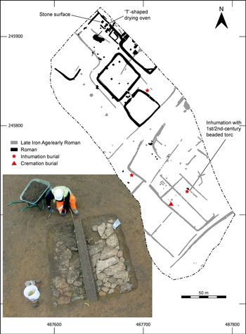
(1) Lathbury, Northampton Road (SP 8758 4573): an open-area excavationFootnote 84 on land previously evaluated in 2000Footnote 85 uncovered part of a late Iron Age/early Roman ‘complex’-type farmstead and associated field-system in a loop of the Great Ouse.Footnote 86 Geophysical survey as part of the evaluation identified similar enclosures to the south, indicating that a number of farmsteads may have existed along the western side of the river during this period. Farmstead activity continued unbroken in the Roman period, with the establishment of new enclosures in the northern half of the excavation area and the likely utilisation of existing late Iron Age/early Roman enclosures to the south. A crop-processing area was indicated by a ‘T’-shaped drying oven and a square stone surface that may have functioned as a threshing floor in one of the new enclosures (fig. 15). Two inhumations and a cremation burial were recovered from the Roman farmstead; one individual was found with a first- to second-century beaded torc.
Lathbury: phase plan and photograph of possible threshing floor. Albion Archaeology.

(2) Leicester, Jewry Wall Museum, St Nicholas Circle (SK 58226 04453): a small excavation was undertaken in advance of a new lift shaft being fitted within the Jewry Wall Museum, at the southern edge of the ruins of the bath complex. A trench measuring c. 6 by 7.5 m was excavated through the floor of the museum, over part of a structure interpreted by Kathleen Kenyon as a water reservoir during the 1930s excavations. It had surviving upstanding walls at the time of the original excavation and was thought to be part of later modifications to the baths. The walls themselves were apparently levelled during the construction of the museum building in 1960. Only the foundations survived in 2019; these were shallow and rested on a levelling layer of redeposited clay. An earlier phase of archaeology was present in the form of a charcoal-rich feature with scorched edges below one of the walls. Post-excavation work is presently at an early stage and therefore the date of the feature has not yet been confirmed. Prior to the current work, the extent to which archaeology survived beneath the museum was unknown. The excavation has established that, despite truncation, archaeological remains are likely to be preserved well.Footnote 87
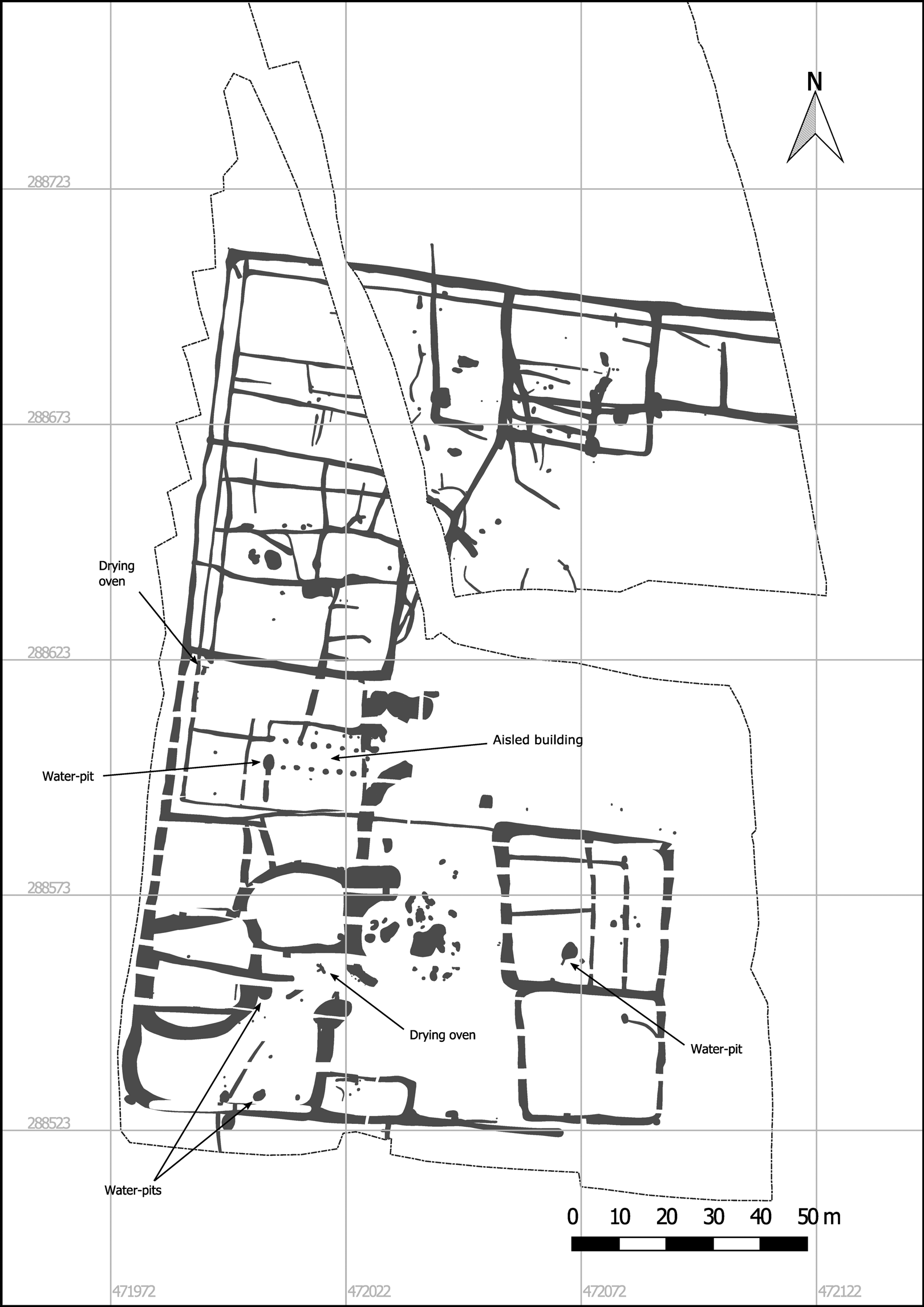
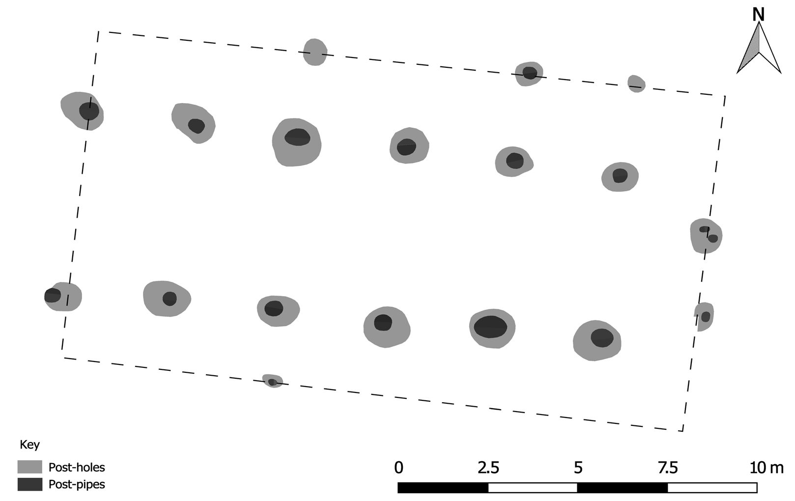
(3) Market Harborough, Airfield Farm (SP 718 884): a second- to third-century Roman settlement, which extended over an area of c. 2 ha, was excavated.Footnote 88 A system of rectangular enclosures existed within extensive ‘outer’ boundaries on its northern, western and southern sides (fig. 16). As such, it was similar in layout and size to the settlement at Seagrave Road, Sileby.Footnote 89 There was definite evidence for one (aisled) building, but the sizes and shapes of some of the smaller enclosures suggest that these may have contained rectangular buildings that have otherwise left no trace. The surviving aisled building comprised two rows of large ‘nave’ post-pits, c. 1 m in diameter, c. 0.5 m deep and regularly spaced c. 3 m apart (fig. 17). Based on the length of these rows, the nave would have been at least 15 m long and 5.2 m wide. Four post-holes to the north and one to the south are probably evidence of the outer wall of the building, suggesting that the aisles were c. 2 m and 2.5 m wide. Two further post-pits to the east may indicate the location of the main doorway. These and the arrangement of the contemporary enclosure ditch suggest the overall dimensions of the building could be 18 by 10 m. No evidence for internal activity survived. Other evidence for activity within the settlement comprises two truncated possible drying ovens, four water-pits and quarry pits. Only parts of the stone lining of the flues of the possible drying ovens survived; they were c. 1.7m long, c. 0.70m wide and up to c. 0.1 m deep. The finds assemblage from the settlement includes pottery dominated by local wares, eight quern fragments, six coins, a bow brooch, a hair pin, a lead-alloy spoon, five iron timber nails, ferrous slag (868 g) and fuel ash slag (6 kg).
Market Harborough, Airfield Farm: plan of the Roman settlement. (Albion Archaeology)

Market Harborough, Airfield Farm: plan of the aisled building. (Albion Archaeology)

(4) Waltham on the Wolds, Fair Farm, Melton Road (SK 80159 24526): an archaeological excavation revealed a complex of Roman multi-phased ditches, gullies and pits. Three sub-rectilinear enclosures were located. A cluster of ten corn driers/industrial features was excavated to the east of the enclosures. These provided a large quantity of Roman pottery, including some near-complete vessels, and quern fragments, along with good environmental remains from the abundance of heavily burnt material in the base of these features. A concentration of intercutting pits just to the west of the central enclosure yielded an abundance of Roman pottery of differing vessels and types, including those more commonly found in Lincolnshire and southern Yorkshire. Two shallow well/watering-hole-type features were also excavated; both cut into pre-existing ditches and cut down through the ironstone bedrock, which preserved their shape.Footnote 90
NORTHAMPTONSHIRE
(1) Boughton, Buckton Fields (SP 7395 6490): an excavation was undertaken between June 2018 and April 2019 just to the north of Northampton in an east–west oriented valley sitting slightly above the floodplain of the Brampton branch of the river Nene. Phase 1 of the archaeological work has been completed and this note reports on phase 2. Roman features comprise a cemetery and agricultural landscape associated with a settlement. The cemetery included 35 inhumation graves and three cremation burials, almost entirely of adults. Four individuals were interred within stone cists, and other burial rites include seven prone burials and four decapitations. Two burials were dated by radiocarbon analyses to cal. a.d. 132–330 and cal. a.d. 244–531, suggesting that the cemetery was in use for an extended period during the middle and late Roman period. Field boundaries and enclosures extended across both sides of the valley, and a ditched trackway extended along the base. Of particular note is evidence for crop processing, in the form of debris dumped in an early Roman ring gully at the western end of the site, and an unusual stone-built structure to the east that is probably a malting oven.Footnote 91
OXFORDSHIRE
(1) Long Hanborough, land south of Witney Road (SP 4120 1400): evaluation and excavation was undertaken in 2017 over an area of c. 6,100 m2 in advance of residential development.Footnote 92 A small enclosure was found which contained two large pits and an ‘S’-shaped gully, likely to be the foundation trench for a wattle fence or similar structure. Both the pits and fence foundation contained charcoal and baked clay consistent with burning. A ditch extended north from the enclosure. Of particular interest was a small plough-damaged cremation cemetery found north-west of this ditch. One pit contained cremated bone in association with a pottery funerary urn, also a large piece of conglomerate and a number of heat-affected pebbles. Another three pits had charcoal-rich fills and cremated remains interpreted as pyre debris. Associated with these features is a pottery assemblage dominated by grog-tempered wares of later Iron Age to early Roman date; some or all of these are likely to be early products of the Oxfordshire industry. The discovery of nine deposits of cremated human bone and 621 fragments of fired clay suggests a funerary enclosure has been discovered, separate from the settlement which is known to have existed on the higher ground immediately to the west of the area of excavations.
This cemetery appears to be contemporary with the north Oxfordshire Grim's Ditch, which was established in the first quarter of the first century a.d.Footnote 93 This feature has recently been identified just to the north of the site on the other side of Witney Road;Footnote 94 as such, the projected line of the ditch should run just to the west of this excavation site. This monument would therefore have been a significant feature of the local landscape during the period when the site was in use and may have implications for understanding the function of the site.
(2) Tackley, Street Farm, Nethercote Road (SP 4809 2068): excavation of a 1.3 ha site prior to the construction of a new residential development in 2017 and 2018 revealed occupation throughout the Roman period. Early Roman post-built structures were replaced in the middle to late second century by a masonry villa, formed of two linked buildings, with limestone walls and mortared floors. This was extended in the third century. Three rooms had mosaic floors and painted wall-plaster. The end of the third century or start of the fourth saw the abandonment and collapse of the villa buildings, yet a large volume of archaeological features can be assigned to this phase, with the construction of structures with different functions from the residential use of the original buildings.Footnote 95
STAFFORDSHIRE
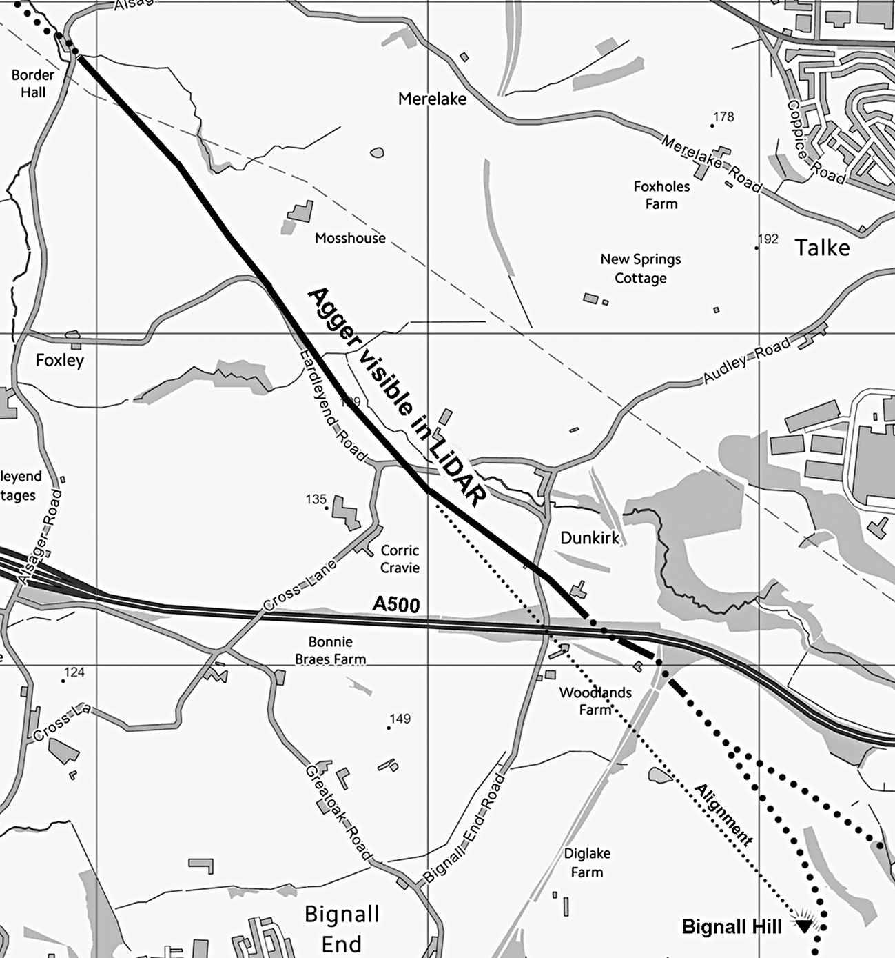
(1) Bignall Hill, King Street (SJ 82144 51205): the route of King Street is well documented within Cheshire, but south of Sandbach and onwards to the fort at Chesterton its course was lost. The road has now been traced, using LiDAR technology, from Middlewich passing Sandbach, where it appears to be aligned on the high ground of Bignall Hill. An alternative route via Lawton Heath was suggested over 100 years ago by W.T. Watkin, but he did caution this and thought a direct route more likely.Footnote 96 We can now be confident (the LiDAR evidence is unambiguous) that the route took a very direct course over Bignall Hill (SJ 79927 53863 – SJ 80224 53538 – SJ 80863 52643 – SJ 81752 51916) (fig. 18). There is still a gap, however, in the LiDAR coverage on the hilltop, so, although the ascent is not now in doubt, the actual course across the hill remains uncertain.Footnote 97
Bignall Hill: Opendata map showing the course of the Roman road on the ascent of, and the alignment on, Bignall Hill.

WARWICKSHIRE
(1) Mancetter-Hartshill (SP 326 942): an audit of the Mancetter-Hartshill Roman pottery kiln excavation archive (1960–84) has been prepared by C.J. Evans and D. Hurst.Footnote 98
WORCESTERSHIRE
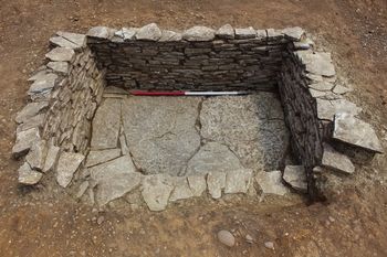
(1) Offenham, biomass shed site, Laurels Road (SP 5740 5330): an excavation was undertaken over an area of c. 892 m2 within the footprint of a new agricultural building.Footnote 99 The site was located on sloping ground between the Broadway brook and Laurels Road, in close proximity to a 19th-century discovery of Romano-British burials. There was no preceding geophysical survey or evaluation trenching, however, so the survival of archaeology in this specific location was uncertain. Multiple phases of archaeology were identified, although Romano-British agrarian activity, particularly between the late second and late fourth centuries, was prominent. A well-built rectangular stone structure thought to be a water-tank was a notable feature (fig. 19). The presence of a possible ‘curse tablet’, a rolled and flattened sheet of lead, found close to the water-tank, may raise the possibility that there was also some votive focus. Other finds include window glass and box-flue tile, animal bones and neonatal human remains. The substantial water-tank and high-status finds suggest a nearby settlement, possibly a villa complex. There was no evidence of continuity into the Saxon period.
Offenham: stone-built tank, stone slab removed, facing south-east (1 m scale).

SUPPLEMENTARY MATERIAL
For supplementary material for this article, please visit https://doi.org/10.1017/S0068113X20000422