INTRODUCTION
Globally, wide-scale land clearing and land conversion for the production of food and fibre has resulted in ecosystem degradation (MA [Millennium Ecosystem Assessment] 2003). These patterns of historical land use and management have a pervasive legacy on the character and ecological function of native vegetation within contemporary landscapes (Scoones Reference Scoones1999; Foster et al. Reference Foster, Swanson, Aber, Burke, Brokaw, Tilman and Knapp2003; Balée Reference Balée2006; Rhemtulla et al. Reference Rhemtulla, Mladenoff and Clayton2009) with implications for vegetation change trajectories (for example Valtinat et al. Reference Valtinat, Bruun and Brunet2008) and restoration potential (Lunt & Spooner Reference Lunt and Spooner2005). Therefore, an appreciation of landscape history can help natural resource managers understand how to effect positive change under contemporary management regimes.
In Victoria (Australia), the broad narrative of colonial landscape transformation is well known. The most radical impacts followed the expansion of European colonial settlements in the early- to mid-1800s. For the most part this was driven by the discovery of alluvial gold and the resource demands of a rapidly growing population. The intensity of land management was later accentuated by the increasing profitability of modernized agriculture in the mid-1900s. These massively modified landscapes and further fragmentation have been recognized as a major threat to biodiversity conservation (Vesk & Mac Nally Reference Vesk and Mac Nally2006).
In 1997, the Victorian Government committed to reversing the long-term decline in the extent and quality of native vegetation cover. It remains uncertain to what extent progress is being made toward this objective (ANAO [Australian National Audit office] 2004, 2008; DSE [Department of Sustainability and Environment] 2008), owing to the complexity of natural systems and failure to undertake structured monitoring (Duncan & Wintle Reference Duncan, Wintle, Pettit, Cartwright, Bishop, Lowell, Pullar and Duncan2008). Recent spatial modelling of native vegetation change from satellite data indicated that <1% of the woody vegetation cover in Victoria showed ‘permanent’ gain or loss over the last 15 years (DSE 2008). These analyses were based on pixel sizes of 25 m2 and thus were too coarse to detect the typical scale of restoration activity that occurs on private land. We reasoned that an assessment over a longer time period, within smaller case study areas, was needed to get a sense of the type and trajectory of landscape change in native vegetation cover. Furthermore, because rural landscapes are as much social constructs as they are biophysical entities; constructing a landscape history requires data not only from different spatial scales, but also from the integration of social and ecological inquiry.
Exploring the convergence of social and ecological systems in rural landscapes invariably requires an understanding of the knowledge held by the local community (Calvo-Iglesias et al. Reference Calvo-Iglesias, Crecente-Maseda and Fra-Paleo2006; Alessa et al. Reference Alessa, Kliskey and Brown2007; Knapp & Fernandez-Giminez Reference Knapp and Fernandez-Giminez2009). Integrating interdisciplinary research with participatory research has both pragmatic and philosophical benefits that enable it contribute to solving real-world problems (McDonald et al. Reference McDonald, Bammer and Deane2009). It allows for the synthesis of different experiences and knowledge, between scientific disciplines, and between academic and lay knowledge, and is therefore advantageous for creating a shared understanding of landscape history. By actively engaging local landholders, we sought an increased awareness of continuity and change within communities and a greater understanding of early history free from judgements based on contemporary values. Local knowledge is also of benefit because it: provides a wider range of data sources for validation; provides local context for institutional knowledge and empirical data; and can highlight important local issues or events that are diluted or lost in data analysed at broader scales, or over different time periods (Alessa et al. Reference Alessa, Kliskey and Brown2007).
Participatory research processes are well established in contemporary anthropology and development research (Sillitoe Reference Sillitoe1998) and are increasing in regional natural resource management (NRM) in Australia. Efforts to mesh ‘top-down’ and ‘bottom-up’ transmission of learning has arguably been the essence of more than two decades of the Landcare programme (Campbell & Siepen Reference Campbell and Siepen1994). Efforts to articulate and promote the concept of ‘rapid rural appraisal’ via dialogue began with rural development projects in the 1970s (Chambers Reference Chambers1983, Reference Chambers1997). There has been a growing awareness that a participatory process involving rural communities, as partners with researchers in data collection and analysis, can also be a process for community empowerment (Aslin & Brown Reference Aslin and Brown2004; Curtis et al. Reference Curtis, Byron and MacKay2005; Fortmann & Ballard Reference Fortmann and Ballard2009). Despite the increasing use of participatory processes in interdisciplinary research, there has been scant documentation and discussion of successful approaches (McDonald et al. Reference McDonald, Bammer and Deane2009).
This article describes the experience of a new interdisciplinary collaboration of ecology, social research and natural resource modelling, using a participatory approach to validate and test vegetation cover change data and guide subsequent research. High resolution aerial imagery had been used to characterize landscape cover change in native tree cover over the period from 1946 to 2008. The preliminary results of these analyses were presented in a series of workshops engaging local people and natural resource managers.
The objectives of the workshops were to rapidly learn about the major drivers of landscape change in our case study landscapes and to inform where our subsequent research should focus. In this paper we briefly touch on our success with these practical goals; however, our primary objective here is to review the role that the workshop process played in our developing interdisciplinary collaboration. We are intentionally candid in explaining how the process evolved, in the hope that readers gain maximum insight from our case study. Our overarching purpose in sharing our experience is to encourage other researchers to further develop and implement this kind of approach to compile landscape histories.
METHODS
Study area selection
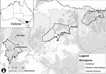
We examined three case study areas in northern Victoria, Australia (Fig. 1): (1) Chiltern-Springhurst, (2) Violet Town-Longwood and (3) Muckleford. Using the categories of McIntyre and Hobbs (Reference McIntyre and Hobbs1999), we identified broad zones of ‘transitional fragmented’ landscapes, which occurred between the extremes of intact and relictual landscapes. These occurred in the Goldfields, Victorian Riverina and Northern Inland Slopes Bioregions, as defined by associations of landform, soils and vegetation (NLWRA [National Land and Water Resources Audit] 2001). These bioregions feature a high diversity of land uses and have received considerable public investment aimed at vegetation protection and enhancement on privately owned land. They also represent significant possibilities for spontaneous regeneration owing to changes towards more intensive land use, which may facilitate land sparing (Crosthwaite et al. Reference Crosthwaite, Malcolm, Moll and Dorrough2008; Dorrough et al. Reference Dorrough, Vesk and Moll2008). Private landholders manage more than 60% of these landscapes. The socioeconomic character of these areas has been broadly characterized as ‘rural amenity’ and ‘rural transitional’ landscapes (Barr et al. Reference Barr, Wilkinson and Karunaratne2005). Formerly dominant farming practices such as livestock gazing are decreasing in area and intensity, whilst rural residential, peri-urban, wine and olive growing, and hobby farm uses are increasing, and pushing land values beyond their value for extensive grazing.
(1) Chiltern-Springhurst, (2) Violet Town-Longwood and (3) Muckleford case study areas in northern Victoria (Australia) in their bioregional context. Major towns and extant cover of mature native woody vegetation (grey shading) are also shown.

Vegetation change mapping
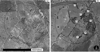
The key spatial data presented to the workshops were maps depicting native tree cover change between 1946 and 2008. Using a lattice of circular survey windows with a diameter of 1.5 km placed at intervals of 3 km (Fig. 2), digitized and geo-rectified black and white aerial photographs taken in 1946 were compared to aerial orthophotographs taken between 2004 and 2008 in ArcView (version 9.3, ESRI). The resolution of the imagery, measured as individual pixel size, varied between 80–85 cm for the 1940s imagery and 12–100 cm for the 2004–2008 imagery. In the latter instance the resolution of most images was 35–50 cm.
Example of the 1.5 km diameter grid circles used to assess landscape scale vegetation change, superimposed over aerial imagery from (a) 1946 and (b) 2007. Hatched zones represent mature native wooded vegetation change that occurred between 1946 and 2008: horizontal solid lines, A = gain; diagonal solid lines, B = loss of scattered trees; horizontal dashed lines, C = an increase in tree density, and diagonal dashed lines, D = a decrease in tree density.

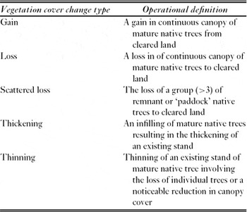
Change in mature native tree cover was mapped and attributed using one of five categories: gain, loss, scattered loss, thickening or thinning (see Table 1 for operational definitions). Sub-canopy woody and non-woody vegetation was excluded from the mapping process owing to difficulties with the old imagery in differentiating between sub canopy woody exotic and native species, and the low detectability of non-woody species.
Operational definitions of the mature vegetation change types we used in mapping change in cover between the 1940s and 2004–2008.

The research team and the participatory workshops
Our research team of four was led by a landscape ecologist (David Duncan), and included a rural sociologist (Digby Race), who coordinated the workshops, another ecologist with experience in GIS applications (Garreth Kyle) and a natural resource management modeller (Wendy Merritt). The landscape ecologist and the rural sociologist both had more than five years experience working in the study landscapes. Within each case study area we were already partnered with a natural resource manager with a sound local knowledge. They liaised with the research team and prospective workshop participants during the planning phase. Our workshop objectives were to: (1) verify derived maps of native vegetation change between 1946 and 2004; (2) highlight important drivers of change that could be further investigated with social and spatial research; (3) identify key time periods in the history of the case study area for which further aerial photographs should be pursued; and (4) provide context and direction for more detailed landholder interviews.
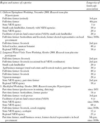
For each workshop we sought the participation of a haphazardly stratified convenience sample of 8–12 local landholders (managers) and natural resource professionals, resulting in 29 participants (Table 2). These people were suggested by the natural resources manager within each region for their respective local historical knowledge and knowledge of ecological issues within the landscape. We sought relatively keen observers of change in human and other natural dimensions of the landscape, spread across production and conservation biases (namely farmers and natural resource managers) and the physical landscape, with longevity of association with the case study areas. Prospective participants were usually contacted by telephone and then sent a formal invitation outlining the purpose of the workshops and our expectations of participants on the day.
Characterization of the expertise and longevity of landscape association (expressed as years [yr], generations [gen] or arrival date), as volunteered by participants for each of three workshops. There were no participants in common between workshops.

The research team hosted an informal dinner for participants the night prior to the workshops. The purpose of the dinner was to establish some rapport between the team and participants, to activate the memories of participants about the history of their area, and prompt the team to think about the themes that may emerge during the workshop. The research team undertook a guided half-day field trip on the morning of the workshop to view sites and landscapes characteristic of the region to further inform the research team about local context.
The workshops ran for approximately two and a half hours and featured two distinct elements. Firstly, we ran a data session which focused on the period after the 1940s, for which we had mapped vegetation cover change. Secondly, facilitated discussion explored not only the change since the 1940s, but also the period following European settlement when the first phase of clearing native vegetation occurred. Our intention had been to focus on the period for which we had corresponding imagery, but we deferred to the participants’ view that the story could not be told that way.
Data session
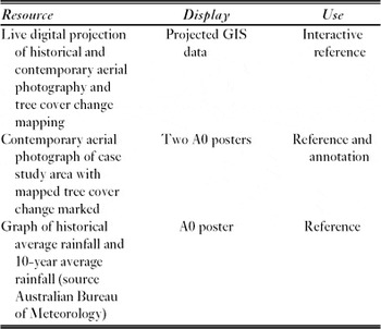
After a brief overview of the method and purpose of the day, the research team introduced the vegetation change maps and sought discussion. This process used pre-prepared resources (Table 3). Participants were encouraged to annotate the hard copy map of the case study area with an outline of the area with which they considered themselves particularly familiar. Thereafter, with the help of the research team, participants were asked to provide, wherever possible, explanations for individual polygons of mapped change and to validate or correct them. The conversations during this session were deliberately interactive, with participants encouraged to mark specific sites or events on the printed maps as they spoke (see Fig. 3). These conversations were not directed via the facilitator, but were encouraged to occur during ‘break out’ sessions, where local participants talked amongst themselves as well as with the research team. These sessions were particularly lively, and simultaneous, animated conversations were common. Even with a team of four, we felt it was hard to capture everything that was happening unless it was marked down on a map.
Visual resources available for workshop participants’ reference and interaction.

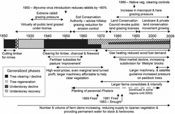
Sample timeline for the Muckleford case study area based on map annotations and facilitated discussion. Positive or negative net trends are indicated by shading (see legend inset). These bars, and durations of influence of individual factors, are indicative only. Overlap of positive and negative trends in understorey change reflects divergence in site responses depending on exposure to intensifying land use and grazing pressure.

Facilitated discussion
The facilitated discussion was structured around themes representing the prevalent socioeconomic and institutional influences on rural land use. This discussion focused on the location, timing and type of events that influenced drivers of vegetation change. It followed a loose chronological order beginning around the mid 1800s. The discussion involved the entire group together, and thus the information that was captured should be regarded as a consensus view, rather than encapsulating a range of opinions. The facilitator recorded notes on a board so that participants could be confident that their comments were recorded faithfully. The group was also allowed opportunity for clarification or expansion of the text recorded for each topic. In general, there was very little in the way of disagreement beyond the timing of certain events.
Each research team member took their own notes, and a short debrief was held immediately after each workshop to ensure that the key points had been documented. Each team member subsequently wrote up their own notes, which were then compiled into one joint summary of the findings for each region. A conceptual timeline that dealt with the key historical influences on vegetation was also constructed for each region. A summary report featuring a written narrative and the timeline was sent out to participants within six weeks of the workshops seeking their corrections and or additional information. Feedback provided by the participants was incorporated into a final version of the summary reports (Race et al. Reference Race, Duncan, Kyle and Merritt2009a, Reference Race, Duncan, Kyle and Merrittb, Reference Race, Duncan, Kyle and Merrittc).
RESULTS
Across each of our three case study areas, the bulk of the clearing of native vegetation had occurred prior to the 1940s when the aerial imagery record began. Workshop participants told how the rapid expansion of settlements in the mid 1800s saw a dramatic decline in the landscape cover of native trees. Almost half of our participants’ families were part of those early settlements and thus were able to broadly characterize the nature of the landscape change as observed by their forebears. Within the Muckleford and Chiltern–Springhurst regions, timber was primarily removed to provide firewood, bracing for mines and to facilitate prospecting. In the Longwood–Violet Town region, vegetation was cleared to provide timber for building, fencing and firewood and to make way for agriculture. Indeed, the initial clearing phase was more dramatic than many today assume. Workshop participants also highlighted that widespread secondary forest and woodland regeneration occurred as the surface gold became scarce on the infertile hill country. These profound changes to the landscape occurred prior to the aerial photo record, though some glimpses could be seen in the personal photographs of participants’ forebears.
Through the workshops we determined that we needed to acquire aerial photography for two time series, 1970 and 1990, for further comparisons. The beginning of the 1970s represented the end of a significant period of agricultural and socioeconomic expansion in the case study areas (Fig. 3). The initial period of clearance in the mid-1800s was followed by a period of relative stability that allowed some secondary forest and woodland regeneration. This ended with the depression of the 1930s, which triggered another wave of clearing to provide timber for charcoal and as a source of jobs for unemployed workers leaving the cities. Further vegetation clearance occurred as a result of the boom in commodity prices after World War Two. In particular, the increase in wool prices made the grazing of more marginal land viable, resulting in sub-canopy grazing or the complete clearance of stands of native vegetation. By the 1970s, wool prices had declined, resulting in the abandonment of grazing in more the marginal lands. In 1970, the Victorian government passed the Land Conservation Act, resulting in the establishment of the Land Conservation Council (Clode Reference Clode2006). The Council conducted a review of grazing on public lands that resulted in the withdrawal of public land grazing licences, particularly from hilltops and slopes. Thus, the early 1970s represent a potential inflection point for vegetation change since 1946.
The period around the late 1980s and beginning of the 1990s should provide a reference point from which to assess the results of a series of positive influences on native vegetation cover. Participants across all three workshops referenced the rise of the Landcare movement, which helped raise the profile of native biodiversity in the consciousness of many rural landholders. Furthermore, legislative changes were introduced in 1989 to control clearance of native vegetation on private land across the State. More locally, changing land use also had a positive effect on native vegetation towards the end of the 1980s, when the first of the lifestyle blocks began to appear (Fig. 3). More often than not, new landholders viewed native vegetation favourably, or at least lacked the motivation or farm machinery to prevent regeneration.
DISCUSSION
The participatory approach we employed provided an opportunity to draw together local knowledge to directly link socioeconomic and biophysical factors with new spatial data, as well as validate our maps of vegetation change. Hard copy versions of these maps allowed participants to annotate individual polygons of change, confirming or refuting their accuracy and providing explanations for individual parcels of vegetation change. The effectiveness of the hard copy maps was enhanced when combined with electronic versions using geographic information system (GIS) software. These could be superimposed over the imagery, providing participants with additional points of reference within the landscape. The mixture of data, hard copy and electronic maps, and conversation covered the range of modes in which different people felt comfortable to make a contribution.
These regional workshops were conceived of as a quick and efficient way to harvest knowledge concerning the historical and contemporary drivers of native woody vegetation change within our case study areas. The steps used by the research team have been outlined above to provide some transparency to a process that proved effective for the purpose of this research, and which could be employed by other researchers to develop an appropriate process for generating new knowledge. In evaluating the contribution of this exercise to our objectives, there are two major considerations for discussion. Firstly, how did the insights about landscape history that we gained from this process assist us in achieving our research objectives, and could these insights have been as easily gained from alternative methods of landscape assessment? This question we discuss only with respect to our provisional findings to this point as the landscape change drivers posited by workshop participants are to be further validated by the ensuing research project. Secondly, how useful was this workshop approach to the function of our interdisciplinary research team? The approach described in this report was an attempt to bridge the social and natural sciences. It was hoped it would contribute to a shared epistemology between research disciplines, and between researchers and the local community. However, it is an approach that should not be underestimated in terms of transaction costs. With the benefit of hindsight, we also offer recommendations that might have enhanced the value the workshops for our research team.
Benefits of the workshops for our interdisciplinary project
The regional workshops were conceived of as a quick and efficient way to harvest knowledge concerning the historical and contemporary drivers of vegetation condition, and ground truth vegetation change mapping. The workshops yielded invaluable insights into the major drivers of broad changes in native vegetation cover that had occurred in the three study areas during the time since European settlement. This information about key drivers, when they occurred, and how they differed between the case study areas, was necessary to direct the ensuing research.
The success of this method can be assessed by comparing the relative effort required to achieve the same information value by alternate approaches. For example, published local histories or historical societies’ collections can offer relatively fine scale spatial and temporal information about social, economic and environmental changes of interest (for example Caniambo-Gowangardie-Tamleugh History Committee 1985). Equivalent information about the timing and spatial extent of the major drivers that were elicited during workshops could have been extracted from a literature search of published local histories. This would have involved a potentially time consuming search of several libraries in each of three regions. There are two important advantages of the workshops over a literature search. The first is that we could focus not just on generic socioenvironmental landscape histories, but specifically on how changes had influenced native vegetation. The second is that we were able to spatially reference information from participants immediately.
Direct engagement with locals in regional workshops had several further advantages over a detailed search of literature. Interaction with the residents and natural resources managers enabled us to examine local variability. While there were several commonalities across the case study region, there were also factors that were distinct to sub-regions. The perspective provided by local landholders also supplied us with an understanding of the hierarchy and interactions of the factors that influence native vegetation within each region and their interactions. For example, declining wool prices were an important driver of reduced sheep numbers in the landscape. However, workshop participants emphasized that it was the combination of this long-term stressor with sudden and severe drought that broke the inter-generational commitment to grazing industries. This resulted in the cessation of grazing on marginal lands that allowed native trees and shrubs to regenerate. Lastly, because the workshops were an open forum, ideas proposed by participants were heard by others and often discussed. These discussions gave us an opportunity to observe whether there was agreement or divergence of opinion regarding timing and impact of different factors.
Whilst the recollections of farmers and landholders may offer a valuable source of information for documenting land-use practices and landscape change, we must be as cautious of such insights as we would be of any other type of data. Landholders often express a deep stewardship ethic, but they may not necessarily observe or understand all changes to native vegetation that may occur in their area, such as when subtle changes occur over several decades (Knapp & Fernandez-Giminez Reference Knapp and Fernandez-Giminez2008). Differing views may exist within a local community about the state of natural resources and the degree of change and importance of drivers, particularly with regard to change over a long period of time (Cocks Reference Cocks1992; Merritt et al. Reference Merritt, Duncan, Kyle, Race, Anderssen, Braddock and Newham2009). Furthermore, the longevity of historical knowledge may be limited by high property turnover. In some regions of Victoria, as many as 50% of properties changed ownership over the past decade (Mendham & Curtis Reference Mendham and Curtis2010). The incoming landholders are often more sympathetic to environmental conservation ideas than most farmers, but are usually less dependent on the local environment for their livelihood. It has been demonstrated elsewhere that the average ecological knowledge of people in wealthier countries and communities becomes impoverished as livelihoods depend less on paying attention to environment (Pilgrim et al. Reference Pilgrim, Cullen, Smith and Pretty2008), and we might expect this pattern to be repeated as a function of socioeconomic mobility within our case study areas. Lastly, Palmer and Wadley (Reference Palmer and Wadley2007) argued that what informants may say about their local environment may not necessarily represent their environmental knowledge. Thus, as Chalmers and Fabricius (Reference Chalmers and Fabricius2007) argued, just as the knowledge of local communities can complement that of conventional science, data from both sources can also be flawed. In our case, because we envisaged these workshops as a pilot activity, we did not invest sufficiently in the sample size and construction, or in cross-validation of data, to be confident of the findings in and of themselves. We will learn more in hindsight about the inferential value of workshop findings as our investigation proceeds.
Benefits of working across disciplines for the workshops
The workshop process provided an early opportunity in our interdisciplinary project to develop a shared understanding amongst ecologists, social researchers and environmental modellers of the nature and scale of the key issues that we would need to deal with. The expertise in recording oral accounts and facilitating discussion from social research, spatial data manipulation from ecology, and model structure elicitation from catchment modelling, combined well to capture participants’ contributions. Each researcher's disciplinary training allowed them to lead and later draw from distinct aspects of the workshop. Also, as all of the research teams involved in this study were represented, our subsequent discussions of the findings were effectively calibrated, so that differences in research paradigms and language were easily understood. Thus, the function of our interdisciplinary research team benefited as much from the workshops as the workshops benefited from the interdisciplinary nature of the team. The workshops also proved an effective point of engagement and communication with local landholders and NRM agency staff associated with the project.
In many ways we did not anticipate the opportunity that the workshops represented. If we were starting a similar process now, we would have allowed more time and sought more experience to capitalize on the invaluable resource of people's time and enthusiasm. For example, whilst we always anticipated using the findings to help inform our modellers about key social drivers of landscape change, we had not initially planned to include a modeller in the workshop. However, the presence of a modeller, listening to proceedings but otherwise free from responsibility, resulted in the creation of more informative models based on an informed history of the landscape (Merritt et al. Reference Merritt, Duncan, Kyle, Race, Anderssen, Braddock and Newham2009). Similarly, whilst we always anticipated further validating our provisional vegetation change data, during the first workshop it became apparent that these data were also useful for stimulating discussion. Whilst geospatial data and social research methods have previously been effectively combined to explain drivers of recent phenomena (such as wildfires; Dennis et al. Reference Dennis, Mayer, Applegate, Chokkalingam, Colfer, Kurniawan, Lachowski, Maus, Permana and Ruchiat2005), we only realized during the first workshop that some participants could confidently identify the specific cause of instances of historical change. Thus, while our process evolved, prior knowledge would have allowed us to take better advantage of the opportunities the workshops presented.
Designing a participatory approach that seeks to hear the views across scientific disciplines, and across different scientific and community spheres, is not straightforward (Sillitoe Reference Sillitoe1998; Pohl Reference Pohl2005). Participatory processes are not inherently time- and cost-efficient, and may create non-standardized information that is difficult to translate to other settings (Fraser et al. Reference Fraser, Dougill, Mabee, Reed and McAlpine2006). However, we believe that, with appropriate experience and adequate resources, it should be possible to design and implement a process that elicits valuable spatially-referenced information for a modest outlay of time and resources. In our case, we sought information on the drivers of historical landscape change in native vegetation cover, as a means to contextualize the impact of more recent government investment toward reversing the decline in native vegetation cover. Our aim was primarily a practical one, but ultimately there may be more profound rewards for more comprehensive adoption of this type of participatory research. The process of sharing local and scientific knowledge may transform the relationship between landholders and NRM organizations towards a position where each group is more accepting of the other's perspective (Ballard et al. Reference Ballard, Fernandez-Gimenez and Sturtevant2008; Fortmann & Ballard Reference Fortmann and Ballard2009). Policies and programmes that reflect an understanding of local wisdom may be more likely to resonate with local communities and thus succeed.
CONCLUSIONS
The provisional information about drivers and critical phases of change in woody vegetation cover obtained from the regional workshops indicated some clear priorities for our research. Based on these workshops we have aquired digitized georectified aerial imagery from the early 1970s and c. 1990 to capture points of inflection in the change path between the 1940s and the contemporary landscape. Trends that were documented in the regional workshops were earmarked for detailed follow-up in targeted landholder interviews and spatial analyses.
By combining preliminary spatial data on vegetation change with the facilitated workshop model, we invested more time and effort than initially planned, but gained quality insights as a result. We caution that the specific method is not sufficiently well developed or tested to warrant its use as an off-the-shelf research tool. However, in our case the exercise provided valuable additional information and may provide encouragement to others compiling landscape histories.
ACKNOWLEDGEMENTS
We are indebted to the 29 people who generously gave time and energy to our workshops in Chewton, Euroa and Chiltern respectively. For helping us to identify participants and/or guiding our field visits we thank: Geoff Park, Vanessa Keogh, Susan Sleigh, Jacci Campbell, Geoff Robinson and Jim Blackney. Our collaborator Wendy Merritt made a substantial contribution to real-time recording the findings of the workshops and their subsequent analysis. Earlier versions of this manuscript were improved by the comments of Ted Lefroy, Vivienne Turner, Nicholas Polunin and two anonymous referees. The Landscape Logic hub is funded by the Australian Government Department of Environment, Water, Heritage and the Arts through the Commonwealth Environmental Research Facilities programme.