BERKSHIRE
(1) Bracknell, Foxley Oaks (SU 83862 70268): geophysical survey identified a potential enclosure ditch with surrounding linear and discrete features in one field, and indicated the other fields were blank.Footnote 167 Trenches confirmed the presence of an early Roman enclosure and surrounding associated ditches to the north and east. An additional trench was agreed upon to further explore the area to the north-east of the enclosure, and further associated ditches were identified. A concentration of early Roman activity was confirmed centring on the potential enclosure.
(2) Finchampstead, land off Longwater Road (SU 79633 62705): evaluation recorded a number of Iron Age/early Roman boundary ditches, two of which may represent enclosures, and a pit.Footnote 168 Iron waste and fired clay recovered from the fills of some of the ditches seem to indicate smithing on or near the site between the first century b.c. and first century a.d.
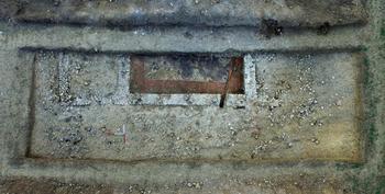
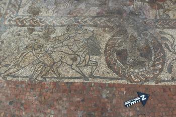
(3) Newbury, Boxford Community Project: a collaborative community research project revealed a Roman villa and associated barn.Footnote 169 The villa contained a bath suite and a well-preserved mosaic pavement (fig. 30). The mosaic was highly decorated and depicts figures from Greek mythology, including Bellerophon, Cupid and Hercules; it represents a rare design not previously encountered in Britain (fig. 31). Initial dating suggests a mid/late fourth-century date for the mosaic. Other finds from the site include a spatula handle depicting Minerva that was probably used for smoothing wax writing-tablets.
Boxford. Aerial view of the villa trench. (Drone photograph by Richard Miller)

Boxford. The mosaic.

EAST SUSSEX
(1) Crowborough, Rockington Nursery, Blackness Road (TQ 5278 2971): a modest number of features mostly of late Iron Age/early Roman date representing a small settlement were recorded.Footnote 170 The site appears to be fairly low status with all of the pottery being local coarsewares. Some tiny scraps of what is probably briquetage were also present. It adds to the limited corpus of sites recorded in The Weald.
(2) Hellingly, land east of Park Road (TQ 59269 11422): excavations revealed the remains of an early Roman enclosed settlement.Footnote 171 Two roundhouses and a post-built rectangular structure were identified within the ditched enclosure, showing continuation of occupation from the Iron Age to the Roman period. Pottery dating to the second century was recovered from the rectangular building and pottery ranging from the first to third centuries was recovered from the enclosure ditch. To the east of the settlement a number of intercutting Roman ditches were identified, some of which appeared to represent the remains of a trackway leading to a small enclosure (possibly a corral), likely relating to the enclosed settlement.
(3) Plumpton, Plumpton College (TQ 360 147): continued programme of research and training excavations.Footnote 172 The trench was extended westwards to investigate part of a large rectangular building thought to be a bath-house. At the other end of the site further work was undertaken to investigate the below-floor-level heating system in the large room at the east end of the line of five rooms comprising the northern part of the main villa building. This proved to be a chalk and flint channel hypocaust with six parallel cross-walls c. 80 cm wide with channels c. 20 cm wide between each wall. It is similar to that found in Room 4 at the Ashtead villa in Surrey.Footnote 173 To the east of the winged house, trial-trenching of the extensive spread of large flints revealed underlying masonry foundations and finds, including carbonised cereal grains and some first-century a.d. pottery. This area will be further investigated in 2018, together with a now fully exposed bath-house to the west. Most of the main house has now been reburied.Footnote 174
KENT
(1) Canterbury (Durovernum Cantiacorum): (a) South Precincts, Canterbury Cathedral (TR 15050 57894): lengths of Roman wall, an associated clay floor and flint metallings were recorded in three borehole pits sunk as part of drainage works.Footnote 175 The wall in borehole pit 1 was abutted on its north-eastern side by a sequence of clay floor and occupation deposits, whilst a flint metalled surface lay north-east of the wall in borehole pit 2. A probable occupation deposit was observed at the base of borehole pit 3. These structures and deposits were probably the remnants of town-houses; others, revealed by excavations in 1993, are known to lie below the Cathedral Church nave.Footnote 176 In borehole pit 2, a robber trench removed the southern length of the exposed Roman wall. Overlying the robber trench, and the Roman remains elsewhere, were demolition deposits of soil containing quantities of structural debris including flint, mortar, brick, tile, daub, tesserae and fragments of painted plaster. The deposits would have formed after the buildings were abandoned and dismantled, perhaps in the later third or fourth century.
(b) Braymor House, Queens Avenue (TR 14196 57975): evaluation prior to residential development recorded a ditch and a clay quarry, dated by pottery to the late first to early second century.Footnote 177 The quarry is indicative of well-attested industrial activity on the periphery of Canterbury's suburbs, commonly brick and tile production. Finds recovered from the quarry, particularly a near-complete early Roman pottery vessel, suggest settlement close by. Pits of a similar date were observed during the subsequent watching-brief.
(c) Yorke Lodge, 50 London Road (TR 13920 58220): a watching-brief maintained during the digging of footings for a house extension, revealed two potential graves.Footnote 178 The graves were unexcavated as they lay beneath formation level, so no skeletal material was recorded, but hobnails and a near-complete second- to third-century pottery vessel were indicative of grave furnishings.
(2) Charing Heath, Burleigh Farm (TR 92808 49924): excavation revealed late Iron Age/early Roman ditches, pits and a trackway superseded by a trackway, post-holes, pits and a lime kiln.Footnote 179 The lime kiln, dating to the mid-first to second century, comprised a combustion chamber, a stoke-pit, a flue and an adjacent working area. Seven of the pits contained potential placed deposits with finds dating to the first to early second century. Evidence for iron smelting was also recorded as well as a possible plough-damaged coin hoard (a.d. 64–85).
(3) Great Mongeham, Cherry Lane (TR 34812 51303): watching-briefFootnote 180 recorded four pits and two parallel ditches of late Iron Age to early Roman date, seemingly part of the native farmstead situated 90 m upslope to the north-west.Footnote 181
(4) Margate, Westwood Village off Haine Road (TR 5535 7365): evaluation uncovered settlement activity spanning the period from a.d. 43 to 410.Footnote 182 Evidence included boundary ditches forming enclosures surrounding possible settlement activity, as well as boundaries demarcating trackways, sunken-featured buildings, refuse pits and chalk extraction or quarry pits. Pits contained evidence for domestic food processing. Pottery from two of the sunken-featured buildings dated to the mid- to late second century; two others, situated adjacent, contained later pottery dating from the late third to the early fifth century.
(5) Teynham, land at Frognal Lane (TQ 95023 62926): evaluation identified Romano-British field boundaries with abundant finds suggestive of a high-status settlement nearby.Footnote 183 Elsewhere on site were two cremation graves containing at least four vessels within a cemetery delineated by two perpendicular walls. The area adjacent to the Rochester to Canterbury Roman road was archaeologically blank, probably due to intensive farming activity.
(6) Thanet, Tothill Street, Minster in Thanet (TR 30750 65450): an evaluation identified pits, chalk quarry pits, a sunken-featured building of first-century date, a metalled road of first- to second-century date, a possible enclosure and a pit with a cremation-related deposit.Footnote 184
(7) Wouldham, Wouldham All Saints Primary School (TQ 71397 63415): a Romano-British pit contained an almost complete Hoo white-slipped redware flagon, broken into 28 sherds. The completeness of the vessel suggests deliberate deposition, a pattern also seen in the late Iron Age remains on site.Footnote 185
SURREY
(1) Charlwood parish (TQ 22 42): five of six exploratory trenches confirmed the existence of parallel ditches which can be followed for c. 40 m east to west, appearing to define a southern boundary.Footnote 186 Finds were few but include a samian jarFootnote 187 and all appear to be early Roman in date. Further trenches revealed parallel ditches running east–west. A complex ditch composition was revealed in two trench extensions necessitated by the discovery of a curving ditch in the main trench. Burnt animal bone was radiocarbon dated to c. 50 b.c.–a.d. 70 and represented butchery and burning of sheep/goat, chicken and pig.Footnote 188 Evidence so far suggests a ceremonial centre rather than a settlement.Footnote 189
WEST SUSSEX
(1) Crawley, land east of Emmanuel Cottage, Rusper Road, Ifield (TQ 24367 36835): a large quantity of Romano-British pottery was recovered from an enclosure ditch suggesting a focus of activity to the north.Footnote 190 A possible oven door fragment may suggest industrial activity. The rest of the site contained evidence of Romano-British background agricultural activity. A series of tree-throws might indicate Romano-British clearance.
(2) Littlehampton, land at Toddington Lane (TQ 0305 0412): excavation revealed an extensive landscape of enclosures dating from the first century b.c. to (probably) the mid-third century.Footnote 191
SUPPLEMENTARY MATERIAL: CONTENTS
For Supplementary Material for this article please visit https://doi.org/10.1017/S0068113X18000399