
Introduction
Geography has been accorded surprisingly little attention in the study of world theatre history. Maps are by no means the sum total of geographic knowledge, but their existence (or the lack thereof) provides a handy indicator of an author's interest in the subject. Oscar G. Brockett and Franklin J. Hildy's History of Theatre has numerous pictures of actors and diagrams of theatres but only one map that directly pertains to theatre. All the rest of its maps (of which there are fewer than two dozen) are standard-issue political maps.Footnote 1Theatre Histories: An Introduction, by Phillip B. Zarrilli and others, is groundbreaking in many ways, but it includes only six maps, and none of these directly concerns theatre.Footnote 2 Each of the six volumes of The World Encyclopedia of Contemporary Theatre includes only one map, a basic political one.Footnote 3 Other standard reference works on the history of theatre contain no maps; these include The Cambridge Guide to Theatre, The Oxford Companion to the Theatre, and The Oxford Encyclopedia of Theatre and Performance. Numerous types of map might be relevant for a study of theatre,Footnote 4 but aside from the occasional political map, the basic overviews of theatre history do not include such resources.
I do not suggest that the authors or editors of these works need have created original maps, although authors of wide-ranging histories often do.Footnote 5 The absence of theatrical maps created by others, however, is a strong indication that the field itself generates few maps; otherwise, the authors would likely have used them in the same way they used other visual materials concerning theatre.
For the purpose of clarity, let me pause to explain that my use of the term “theatre” accords with the typical usage in the aforementioned texts. My concern is with what can more precisely be called dramatic theatre: the portrayal of fictional events by performers who enact the characters of those events. This usage includes both theatre forms that are based on monologue and dialogue and those that use music, song, dance, puppets, and ritual elements to present dramatic enactments. That said, I suspect that much of the following analysis might also apply to a more expansive range of theatre, including nondramatic forms of song, dance, and ritual.
Theatre historians pay great attention to the dimension of time, but humans (as well as all other physical entities) exist not only in time but also in space. Although high-school teachers often reduce geography to the rote memorization of tedious facts such as the names and locations of mountain ranges, the principle crops of world regions, and state and national capitals, geography is in fact a vitally important field of study. Historian Fernand Braudel writes, “Geography seems to me, in its totality, to be the spatial study of society, or, to take my thoughts to their conclusion, the study of society through space.”Footnote 6 Time is of obvious importance, but unless theatre scholars reconceptualize their sense of space, their basic units of geographic study will remain the continent and the nation. As a result, they will continue to overstate the importance of European theatre and obscure both the differences and the similarities among the theatres of different lands.
What follows is a tentative attempt to provide a new way of conceptualizing the geography of world theatre. The first section examines how our current geographic concepts are not adequate for a spatial study of world theatre. The second proposes that a geography of theatre can best be constructed using theatrically organized world regions as the basic unit of study. The third suggests that we also need to recognize lesser and greater units: of particular importance are the concepts of the theatre center (a city or large town that is a center of theatre production) and the megaregion (a set of regions that have had a discernible impact on one another).Footnote 7
I. The Geographic Problem
World maps are usually marked with continents and nations. Continents are understood to be distinct landmasses that endure over vast periods of time. Nations are recognized to be more mutable, but they are recognized to be the most important of contemporary political units and are thus assumed to be of geographic significance. Theatre historians follow the logic of such maps by placing great emphasis on continents and nations as their basic geographic units of study: European and Asian theatre, for example, or French, German, and Chinese theatre. Yet our understanding of the number of continents is far less settled than is generally realized, while the mutability of nations—in terms not only of their borders but also of their very existence—limits their general utility as a unit of analysis. Our uncritical acceptance of continents and nations as the basic ways of organizing knowledge has compromised our ability to make geographic sense of world theatre.
In the contemporary United States, people generally speak of seven continents as if they were self-evident features of the physical world. In other countries, people speak of only six continents. Some combine North and South America into a single American continent, whereas others combine Europe and Asia into a unified Eurasia. If we were to adopt both of these combinations, one might say that there are only five continents. Some people note that Africa is physically connected to Western Asia and posit an Afro-Eurasian continent,Footnote 8 which would reduce the number of continents to four. Finally, all of this accepts that Australia is a very small continent and that Antarctica should be considered a continent—a point that many American geographers, one is surprised to learn, came to accept only in the 1950s.Footnote 9
It is certainly possible, if one squints at a world map, to ignore the Suez connection and see Africa and Eurasia as independent landmasses. Similarly, one can ignore the Isthmus of Panama and imagine North and South America to be independent of one another. We can convince ourselves that these “more or less discrete masses of land . . . are almost distinct” (35; their italics). No stretch of the imagination, however, can allow the map's viewer to see Europe and Asia as anything but a continuous and unbroken landmass. Yet the separation of Europe from Asia is the most fundamental of continental ideas, and Europe is still perceived as “the archetypal continent” (36). This is generally true in texts on theatre history as well: Brockett and Hildy, for example, focus almost exclusively on Europe (and European-derived societies such as the United States) and devote only one chapter to all of Asian theatre. This is no doubt an instance of simple parochialism, but the implication is that European theatre stands apart from the theatre of Asia.
The geographic division between Europe and Asia, however, is anything but certain. The boundary between these two “continents” is traditionally drawn at the waterway comprising the Bosporus Straits, the Sea of Marmora, and the Dardanelles. This boundary might look plausible from a Mediterranean perspective, but these waters have been easily traversed for millennia: Ancient Greeks, Romans, Byzantines, and Ottomans have all settled both east and west of it. So in fact, this waterway is scarcely a boundary at all.
However, even if we were to accept this waterway as a boundary, the idea that Europe and Asia are distinct continents becomes implausible once we look north of the Black Sea. In the late seventeenth century, Europeans drew the northerly section of the continental boundary along stretches of the Don, Volga, Kama, and Ob rivers. (By this logic, North America would be two continents, divided in large part by the Mississippi River.) In the eighteenth century, a Swedish military officer proposed that the boundary be set along the Ural Mountains. This boundary was accepted in the Russia of Peter the Great because it placed the dominant portion of Russia in Europe while consigning the more easterly portion “to the position of an alien Asian realm suitable for colonial rule and exploitation” (27). The problem with the Ural Mountains is that even if one is willing to use a mountain range as a boundary (by which logic, North America would be divided into two continents by the Rocky Mountains), the Urals would not form a very effective barrier: south of them is a six-hundred mile gap that has historically served as an unimpeded highway for armies and settlers passing both east and west. In brief, then, the repeated attempts of Europeans to find a meaningful boundary that would physically separate Europe from Asia (and therefore from Asians) have not been successful.Footnote 10
The immediate (and by no means coincidental) effect of splitting Eurasia into two continents has been to place Europe on an equal footing with the whole of Asia. However, as geographers Martin W. Lewis and Kären E. Wigen point out, “Europe is in actuality but one of half a dozen Eurasian subcontinents, better contrasted to a region such as South Asia than to the rest of the landmass as a whole” (36). The point is not merely an academic one. According to historian Marshall G. S. Hodgson, when one treats the relationship between China and India as analogous to the relationship between Italy and Germany, “a sane interregional history is out of the question.”Footnote 11 In the context of theatre history, Chinese and Indian theatre forms are utterly distinct in origin and development; even today there is remarkably little intercourse between them. Italy and Germany, on the other hand, share all their major theatre forms: scripts, actors, and even whole productions have long passed back and forth over the historically unstable borders of these nations. Placing European theatre on an equal footing with all of Asian theatre misrepresents the realities of geographic scale, grossly exaggerates the importance of European theatre, and denies the depth of heterogeneity in the theatre of the “subcontinents” of Asia.
Europeans have long told themselves that East and West (or, as people used to say, the Orient and the Occident) are appropriate terms for a fundamental global divide. These terms are predicated, of course, on the presumed physical separation of Europe from Asia, but they pair bad geography with dubious psychological generalizations. According to Lewis and Wigen, “Europeans have long been wont to define their own psychosociological qualities in contrast to those of their Eastern neighbors, a habit of thought that shows no signs of decline.” Most important, Westerners see themselves as “autonomous agent[s]” with a restless desire for growth and development, having a “practical, this-worldly orientation” and a “commitment to rational inquiry.” They see the “essence of the East,” on the other hand, “as manifest in communitarian, aesthetic, and other-worldly values, extolling the submission of the individual to a timeless, mystical whole” (73).
I have argued elsewhere that what I call the East–West approach to theatre history presents a false dichotomy predicated on a set of flawed assumptions.Footnote 12 Two of these assumptions are of particular note here. First is the assumption that East and West are coherent wholes that can be spoken of as single entities. Whatever coherence one might care to claim for the West, the East is patently not a single entity. It is a collection of “subcontinents,” some of which have even less involvement with the one another than they have had with the West. In terms of theatre, James R. Brandon states what should be obvious: “There is no single Asian–Oceanic aesthetic of theatre nor is there a single structural pattern, but rather numerous, even opposing, aesthetics and structures.”Footnote 13
The second flawed assumption is that East and West somehow divide the world between them, but of course they do not. For example, what we now know as North and South America have no place in this dichotomy during the precolonial time period; neither does sub-Saharan Africa. Grouping these lands together with the East is not a solution, for they have no more in common with China and India than they do with Europe. It is also quite obvious that the East–West approach fails to account even for some societies in Eurasia itself. Take, for example, theatre in Islamic societies from the Levant to the Khyber Pass: if these societies are not of the East, neither have they ever been taken to be part of the West. This is no doubt the main reason why The World Encyclopedia of Contemporary Theatre devotes an entire volume to The Arab World. Footnote 14 In effect, the only thing the East–West approach accomplishes is to differentiate Europe (along with European-derived societies) from the rest of the world: “the West and the Rest,” as some have put it.Footnote 15
There is one final problem with the continental scheme. However we might number or construe the continents, they are, by definition, land-based. Although most people earn their livelihood on land, continuities of climate and geography are sometimes stronger across seas than across continents. Moreover, intersocietal contact (in particular, commercial contact) has often been conducted across the seas. Why then should the landmass be the sole fundamental geographic unit of analysis? Why not bodies of water as well? The Mediterranean basin is a far more coherent geographical unit than is Europe, as Fernand Braudel demonstrates in his study of the “Middle Sea.”Footnote 16 In her examination of the period from 1250 to 1350, historian Janet Abu-Lughod identifies eight overlapping Eurasian “subsystems” within which interactions were particularly intense: only two of these are land-based.Footnote 17 K. N. Chaudhuri, meanwhile, examines the entire Indian Ocean basin as a unit in the years from the rise of Islam to 1750.Footnote 18 Finally, Joseph Roach in his provocative Cities of the Dead posits a “circum-Atlantic” region that includes portions of the Americas, Africa, and Europe.Footnote 19
In sum, the continental approach is neither strictly geographic nor good social geography. As Lewis and Wigen rightly conclude, “When it comes to mapping global patterns, whether of physical or human phenomena, continents are most often simply irrelevant” (33).
But if such is the case with the continental perspective, a perspective based on national boundaries relies on transient political geography. As S. E. Wilmer notes, with considerable understatement, “What constitutes the geographical borders of the nation often poses a problem for the theatre historian.”Footnote 20 He suggests that one approach to the problem is to “use today's borders retrospectively”; another is to use the borders that existed in whatever period happens to be under examination.Footnote 21 But consider the case of Adam Mickiewicz, an important figure in the Romantic movement who is often considered Poland's greatest playwright. Mickiewicz was born and raised in Vilna (now Vilnius), currently the capital of Lithuania, but he lived for most of his adult life in Paris. When Forefathers' Eve (Dziady), one of his greatest poetic dramas, was first produced in Krakow, the city belonged to the Austro-Hungarian Empire. Whichever set of Polish borders one uses, then, it is difficult to categorize Mickiewicz's home nation. One can generalize this problem by suggesting that political maps do not take into account human movement.Footnote 22 Thus, national borders cannot be said to have anything more than a local, time-bound meaning. Perhaps it makes more sense to posit idealized borders, but this too ignores the fact of movement; it also requires accepting the political assumptions of one or another nation. For example, Marin Držić was a leading Croatian playwright during the Renaissance, but to this day, many Serbs consider significant portions of Croatia to be part of a Greater Serbia.
One way out of these problems is to define nations not as political entities but in terms of those who share the same language. This seems, indeed, to be what people mean when they speak of Mickiewicz as Polish and Držić as Croatian. The obvious problem here, again, is that people and theatre both tend to move about. Consider Samuel Beckett, a native Irishman who spoke English but wrote his plays in French; consider also Tiberio Fiorilli's Italian-speaking commedia dell'arte troupe, which took up residence in seventeenth-century France and played an important role in shaping French theatre. Which nations can rightfully claim Fiorilli's troupe and Beckett as their own?
A further complication here is that in many nations (as defined by borders), theatre is presented in two or more national languages. Examples include Belgium, Switzerland, Canada, and Israel. How is one to deal with “the contradiction between conventional notions of a monolingual national identity and the reality of a multilingual governmental policy”?Footnote 23 In an essay on “the national identity” of Israeli theatre, the authors choose, without comment, to concern themselves only with theatre in Hebrew, despite the fact that Palestinian theatre is regularly performed both in Israel proper and in the regions currently occupied by (and at least partially claimed by) Israel.Footnote 24 A focus on language ignores the reality that different linguistic communities often live cheek by jowl with one another. It ignores, indeed, that multiple languages are sometimes used in a single production—often for audiences comprising speakers of both languages—as with some of the productions by El Teatro Campesino, a Chicano theatre troupe based in San Juan Bautista, California.Footnote 25
Shifting the focus to ethnicity as nationality does not seem to help much. The concept of distinct ethnicities is itself quite problematic because people move about and form familial partnerships across ethnicities. Consider the case of an actress of Slovenian-German descent who appeared in German theatres in territory that is known today as Poland during World War I. Barbara Pušić notes that this actress represents “a kind of terra incognita equally for Slovenian, German, and Polish theatre researchers.”Footnote 26 Genetic testing clearly shows that “despite political fragmentation, migration within Europe has been sufficient to create a greater genetic homogeneity than elsewhere.”Footnote 27 In short, few people are “purely” of any European ethnicity: the Slovenian-German actress is more the norm than the exception.
Almost all of these examples are from Europe, where the delineation of nations has a longer history than anywhere else on earth. How are we to speak of “national theatres” in sub-Saharan Africa, where the concept of nationhood was introduced only recently, or in the precolonial Americas, where nationhood was never known? It is not accurate, for example, to speak of “Nigerian theatre” at any point before that polity's existence. Perhaps one might speak in terms of “tribes,” such as the Yorùbá, but this term is now in some disfavor because (among other reasons) it seems inappropriate when speaking of societies that have many tens of thousands of people, formal governments, and sometimes (as with the Yorùbá) a long history of urban life. It is questionable, though, simply to substitute “nation” for “tribe” (as is sometimes done, especially in regard to Amerindian societies), if only because this returns us to the various problems associated with that term.Footnote 28
There is one last, and highly significant, problem with nationhood as a unit of study, however nationhood might be construed. Brockett and Hildy's History of Theatre is broadly structured on a temporal basis, but for much of the text the perspective is resolutely national. For example, these authors address the European Renaissance (along with the years immediately following that period) in individual chapters devoted to the theatres of Italy, England, Spain, and France. Although there are significant local differences among these theatres in the years under discussion, Brockett and Hildy make no real attempt to articulate those differences. Even more important, they do not attempt to explain the similarities: Why did literary spoken theatre that was generally commercial and secular rather suddenly and simultaneously erupt in all these lands, as well as in other European lands about which these authors do not write?Footnote 29
The example of Renaissance theatre is noteworthy because it demonstrates that a national perspective (again, however one might construe “nation”) obscures the ways that theatre often transcends national boundaries. For four hundred years, Italian, English, and Dutch troupes have performed in German-speaking lands, while for much of that time plays translated from those languages were the regular offering of local troupes and theatres. The German courts, meanwhile, favored Italian operas and French comedies performed in their original languages. In light of all this, Erika Fischer-Lichte suggests that “it makes no sense to write a German national theatre history.”Footnote 30 The case is basically the same, though the details will differ, in most of the world's nations. I am not suggesting that the concepts of nation-states, linguistic nations, ethnic nations, and tribal “nations” are without value; all can be useful (and sometimes inescapable) markers. Still, none is truly suited to serve as a basic geographic unit for world theatre.
It is tempting simply to wash one's hands of trying to make sense of world geography. Postmodernism's aversion to historical metanarratives might well be taken to apply equally to what might be called metageography. Postmodern geography emphasizes “fluidity, contingency, movement, and multiplicity” and is particularly concerned with attacking “the imprisoning thesis of European priority.”Footnote 31 This is all well and good, and my earlier comments on continents and nations take up many of these points. The postmodernist suggestion, though, that all metageographic schemes are intrinsically flawed manages to throw the baby out with the bathwater. Physical geography and human sociality have conspired to give at least some shape to social geography. As geographers Lewis and Wigen rightly contend, we should not “succumb to the postmodern mood and declare the end of metageography altogether. . . . If one is to think seriously about the world, one must have recourse to a spatial vocabulary. In the absence of better alternatives, exhausted metageographical concepts will creep back into use, even in acutely critical postmodern texts” (205).
World Regions and Their Theatre Complexes
A workable alternative to continents, nations, and postmodernist nihilism can be found in the concept of world regions (which, for the sake of simplicity, I will henceforth usually refer to as regions). This concept has had a rather mixed history. All too often, regions have been “distorted by the reification of the nation-state” (13). Thus, a regional boundary is often drawn across the island of New Guinea, along the longitudinal line that separates Indonesia from Papua New Guinea. Nation-states are, without doubt, highly important features of modern geography, but as we have seen, they are by no means the decisive feature in a historical sense. Another problem is that regions (particularly in the sense of civilizations) have sometimes been reified as “natural or suprahistorical entities” (14) that are veritable universes of their own, almost standing outside time. But as we have seen with the example of Europe, there is nothing “natural or suprahistorical” about regions.
These problems are quite avoidable as long as we follow a few basic principles. First, we must acknowledge that regions are “approximate intellectual constructs” (14). Given this acknowledgment, we can still claim with Lewis and Wigen that they “are not entirely made up” but reflect, if only imperfectly, real “cultural and historical relationships” and “real patterns” in the world (14). Second, we must accept that while each region can be studied on its own terms, regions participate in broader interregional activities. These activities do not obviate the concept of regions, though, because each region responds in its own particular way to those activities (14). Finally, we must recognize that concepts about what constitutes regions are anchored in history no less than in geography. Jill Lane, arguing against a rigid cartographic tradition, suggests a “hemispheric” approach that seeks to explore interregional relationships between North and South America: she contends that “history made geography, and not the other way around.”Footnote 32 Lane's “not the other way around,” however, overstates the case. As we shall see, geographic contiguities and oceanic distances have had a significant impact on how regions have developed. It might be better to amend Lane's statement: history shapes geography no less than geography shapes history.
Historian Marshall G. S. Hodgson defines regions as geographic areas in which there are “historical interrelations and interactions, closely-knit enough so that many questions can be dealt with in its terms without spreading out to a still wider region.” Regions are understood to often include “strongly contrasting cultures in juxtaposition.” Thus, in “a hodge-podge like the Far South East [i.e., Southeast Asia] . . . Hindus, Buddhists, Muslims, and Confucians, and finally even Christians, lived out their history so much in each in others' hair that however different their cultural patterns they formed a common region.”Footnote 33
It is not satisfactory, however, to accept regions predicated on matters of general history. Lewis and Wigen argue that “critical metageography” must be based on “contextual specificity” (198–9). For my purposes, of course, the primary context is theatre. We must identify areas where various theatre forms have more than occasional interactions with regard to shared dramatic literature (including textual traditions and themes), shared techniques of performance, shared artists (including writers, actors, musicians, and directors), shared audiences, or shared descent from a common “ancestor” form. If theatre form A has more than occasional interactions with form B, which itself has such interactions with form C, then we can take all these forms as belonging to a single regional theatre complex.
The geographic borders of theatre regions (and their theatre complexes) are often quite fuzzy at best. Border zones, where two or more regional theatre complexes overlap, are home to various theatre forms of those regions, and those forms often exert a notable influence on one another. Just as regions are themselves dependent on history, so too are their border zones. In a few cases, where a particular area contains numerous indigenous forms as well as forms from the theatre complexes around it, we can speak of it as a border region.
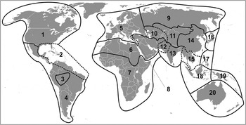
Having said all that, let us take a look at the regions and border regions of world theatre (Fig. 1). I have already suggested that although the concept of Europe as a continent is highly problematic, it is plausible as a region with a theatre complex that currently includes spoken theatre, musical theatre, opera, and ballet, among other forms. The interconnections among these forms are well known and need not be detailed here.
Contemporary world theatre regions. Boundaries between the regions of world theatre are shown as solid lines. Where regions are contiguous, the boundaries should understood as border zones where the influences of the adjoining regions can be found. Border regions are demarcated by dashed lines. My suggestions for the regions and border regions of contemporary world theatre are as follows: (1) North American Region (neo-Europe); (2) African–American Border Region; (3) Ibero-American Region (neo-Europe); (4) Indigenous Ibero-American Region; (5) European Region; (6) Southwest Asian–North African Region; (7) Sub-Saharan African Region; (8) Eastern Mediterranean Border Zone; (9) Northeast Russian Region (neo-Europe); (10) Euro–Central Asian Border Zone; (11) Central Asian Region; (12) North Indian Border Region; (13) South Asian Region; (14) East Asian Region; (15) Continental Southeast Asian Border Region; (16) Japanese Region; (17) Philippine Region; (18) Insular Southeast Asian Region; (19) Melanesian Region; (20) Oceanian (Australia–New Zealand) Region (neo-Europe).

India (or more properly South Asia) provides another example of a regional complex. Many theatre forms in this region concern themselves with stories drawn from the great Sanskrit epics, the Mahābhārata and the Rāmayana; among these are kathakali, chau, and the rām līlā. No less significant, many regional forms follow various traditions of the ancient Sanskrit theatre that include a jester character (originally called a vidūsaka); among these are kūtiyāttam, tamāshā, and the rās līlā. Lest one think that traditional Indian theatre is entirely indebted to Sanskrit theatre, however, we should also note the existence of forms such as nautankī, which also draw on Arabic and Persian tales and (in some cases) performance practices as well. These rather mixed forms remind us of the centuries of Islamic invasions and settlement, and justify identifying a North Indian border region.Footnote 34
Other regions with clear theatre complexes are East Asia (primarily China) and what might be called Southwest Asia–North Africa (composed primarily of theatre forms prevalent in Islamic lands). Insular Southeast Asia also seems a distinct region, as I discuss shortly. Indeed, it might well be that there is also a Central Asian theatre complex, although relatively few of the traditional forms in that rather amorphous area are well documented.
A number of interesting issues are associated with regional theatre complexes. Perhaps the most obvious one concerns the lands that Europeans began colonizing in the sixteenth century. The theatre that developed in these colonies (and now former colonies) is primarily derived from Europe, but it would be strange to speak of, say, Australia as being part of Europe. It is customary to speak of these lands as belonging to “the West,” but the concept of a unified West (as set in opposition to a unified East) has its own set of serious problems.
Historian Alfred W. Crosby has introduced the useful term “Neo-Europes” for the lands subjected to extensive European settlement. He writes, “Geographically they [Neo-Europes] are scattered,” but they have climates that are roughly similar to Europe's, which allowed for the critically important transfer of the plants and animals on which Europeans have historically depended.Footnote 35 Further, the Europeans who settled in these lands eventually drove out or out-populated and subordinated the indigenous populations.Footnote 36 The lands Crosby identifies as “Neo-Europes” include Australia, New Zealand, North America, and much of South America. The sizable portion of South America where indigenous societies were less affected by outside influence (primarily the Amazon basin) should probably be considered its own region.Footnote 37 I should add that when I refer to a land as a neo-Europe, I do not mean to imply that its identity (theatrical or otherwise) is defined exclusively by its colonial history; I mean only that its history (theatrical and otherwise) has been profoundly influenced by European settlement.
• • •
Between the sixteenth and nineteenth centuries, Europeans transported massive numbers of slaves from Africa to the Americas: some 11 million, according to recent estimates, the vast majority of them to Brazil and the Caribbean islands.Footnote 38 Lewis and Wigen designate these lands as a region unto themselves, which they call “African America” (182). This construction makes good sense when we consider the circum-Atlantic world that Roach has posited. I think it best to view this as a border region in which African and neo-European theatrical traditions have deeply mixed. As a result, it is a fine example of a border region that is, in effect, the creation of a forced diaspora, the result of which is the copresence of neo-European and African traditions, alongside entirely indigenous (and syncretic) forms.
Another issue concerns Russia, which spans more than six thousand miles across northern Eurasia. In its western areas, Russia's theatre is clearly European: one thinks of Gogol, Chekhov, Stanislavsky, Mussorgsky (for his operas), and the Imperial Ballet. Even Russian folk theatre (in the western portions of the land) generally fits European patterns.Footnote 39 On the other hand, while various lands east of the Caspian Sea (e.g., Kazakhstan or Uzbekistan) underwent significant “Russification” in the years they were subservient to Russia, they seem to have originally been Central Asian in theatrical orientation.Footnote 40 It is best, therefore to see these lands as belonging to a substantial Euro–Central Asian border zone. Finally, the lightly populated expanses of the northeast (which one can assume was likely once a North Asian region) have also been colonized, starting in the seventeenth century, with Russia rooting a more European culture in newly formed towns and small cities. This recognition of Russia as a colonizing society allows us to consider this portion of Russia as having become a neo-Europe, the European-derived culture of which has been imposed by settling colonists upon the rather sparse population of indigenous peoples.
Japan also presents an interesting case. In Lewis and Wigen's metageographic scheme (as in common discourse) it is seen as part of East Asia (196). The logic for this is not only that there have been periods of extensive trade between Japan and the mainland but also that many important cultural elements have been transmitted from China to Japan, among the most prominent of which are the Confucian system and Buddhism. In terms of theatre, it is likewise appropriate to say that Japan was part of East Asia before the fourteenth century, with many forms of performance (particularly dance and music) having passed across the Sea of Japan.Footnote 41 Since the emergence of nō h, however, Japanese theatre has followed its own distinctive course, in part because of extensive periods of Japanese isolationism. For the past six centuries, Japan has been its own theatre region, with a complex made up of such thoroughly indigenous forms as nōh, kabuki, and bunraku. Chinese theatre (as far back as the heyday of Yuan zaju in the thirteenth century) has scarcely affected Japan. Japanese forms, meanwhile, found a home in China only during the occupation from the 1930s through 1945. Leonard Pronko relates that in the mid-twentieth century, he spoke to a Chinese theatre scholar after viewing a kabuki performance: “Her reaction was that of any foreigner totally unacquainted with the traditions of Kabuki—surprise, wonder, confusion: ‘It was so different, I didn't know what to think!’”Footnote 42
There is also the matter of Southeast Asia. As we have seen, Hodgson refers to it as a “hodge-podge” but accepts it as a region. The theatre of this area (or at least portions thereof) has been studied intensively, owing at least in part to the distinctiveness of the various wayang forms that have long been popular on Southeast Asian islands.Footnote 43 One is led, however, to think that even if all of Southeast Asia is a single coherent region in broader socioeconomic terms, the same does not hold true in terms of theatre.
What I call Insular Southeast Asia includes the various islands of Malaysia and Indonesia, which share a range of closely related wayang forms. These forms (which most often use shadow or rod puppets) are at home throughout the Insular Southeast. Continental Southeast Asia, on the other hand, seems better understood as a prominent border region, having seen the overlap of theatre forms from East Asia, South Asia, and the Insular Southeast as well as the development of its own native (but highly influenced) forms, most of which are limited to specific societies. This border region includes what are now the nations of Burma (Myanmar), Thailand, Cambodia, Laos, and Vietnam, along with the continental portion of Malaysia.Footnote 44
Up to this point, I have been speaking primarily of Eurasia (along with the neo-Europes). The U.S. bank robber Willie Sutton was once asked why he robbed banks. His apocryphal answer: “Because that's where the money is.” Similarly, I have focused on Eurasia because that is where the theatrical information is. Although I do not mean to exclude from discussion either sub-Saharan Africa or the Americas before European colonization, we are faced with something of an information deficit, owing to a number of factors. Very few indigenous societies of these lands were literate, and although oral traditions are now considered to contain important historical information, they are less concerned with reporting historical chronology and facts per se than with shaping the meaning of the past. According to Jan Vansina, “[W]eakness in chronology is one of the greatest limitations of all oral traditions.”Footnote 45 Moreover, most of the available information about these societies is the product of European (and neo-European) missionaries, travelers, and anthropologists. There are serious gaps in this information, not to mention the more than occasional bias of those who collected it. A few comprehensive studies of Amerindian and sub-Saharan theatre history do exist.Footnote 46 These studies, however, are hobbled by the aforementioned data issues. The sub-Saharan studies, moreover, often construct regions on the basis of the languages or national borders imposed by European colonists.Footnote 47 Although this is understandable from a research perspective, it does not accurately reflect whatever indigenous regions have existed. In the past hundred years, for example, West Africa has seen the rise of two remarkable theatre forms stimulated by international trade in port cities such as Accra, Lomé, and Lagos, which have been influenced by European and American performance. Concert party theatre is at home in both Ghana (an Anglophone land) and Togo (a Francophone one), whereas Yorùbá popular traveling theatre is limited to what is now Nigeria but shares appreciable traits with concert party theatre.Footnote 48 Modern linguistic and national boundaries obstruct our understanding of these regional activities.
For all these reasons, one cannot say much about regional theatrical complexes in the precolonial Americas or sub-Saharan Africa. At least some regional demarcations are likely, particularly in the Americas. The Amerindian societies of North America seem to have been distinct enough from those of South America to suggest that North and South America are distinct theatre regions, but this division is little more than an assumption. It might well be, in fact, that there were distinct regions even within North and South America. If nothing else, we need to account for the advanced societies of the Aztec and the Maya (in the Central American land bridge), as well as that of the Inca (in what is now Peru). It is reasonable to think that they, at least, were once discrete regions, but again, this is little more than supposition.Footnote 49 As for sub-Saharan Africa, we are somewhat better informed about particular theatrical traditions (especially in Western Africa), but we know little about wider patterns of theatre. It might well be that distinct regions existed (and continue to exist, beneath the overlay of Euro-derived spoken theatre). If that is the case, evidence from linguistics and genetic studies might give some indication of the contours of such regions.Footnote 50 Until evidence of such regions becomes available, however, it probably best to assume that sub-Saharan Africa constitutes a single theatrical region. Some scholars are willing to make this assumption, seeing the region's theatre as characterized by “certain common features” such as a “non-literary, improvisatory character,” a particular set of “thematic preoccupations,” and a “‘variety show’ format.”Footnote 51 These difficulties in understanding regionalization in the precolonial Americas and sub-Saharan Africa do not invalidate the regional approach; they merely point out the need for further information to refine it.
As I have said, regions are as dependent on history as on geography. Theatre forms can be carried on the backs of ordinary people moving from one place to another; but colonizing elites can also carry them, often on the edge of a sword. At first, the penetration of new forms might be superficial: a theatre or two in which the colonizers perform for themselves or have performances imported from the homeland. In the neo-Europes, settlers eventually annexed more lands, establishing their theatre in the newly colonized locations. In colonies where Europeans did not become majorities, native elites might eventually have become interested in one form of theatre or another; such is the case in India, where spoken theatre has been “domesticated” for some two hundred years and still thrives.
Europeans are certainly the most significant of recent colonizing powers, which is why theatre in the lands they colonized is often the sole focus of postcolonial theatre studies.Footnote 52 Jacqueline Lo and Helen Gilbert write that the term “postcolonial theatre” generally “refers to a range of theatre texts and practices that have emerged from cultures subjected to Western imperialism.”Footnote 53 Europeans, however, are by no means the first colonizers to have transported their theatre.
It is generally thought, for example, that the Vietnamese hat boi is directly descended from early thirteenth-century Chinese theatre, a time when Vietnam was under attack from Mongol invaders from China.Footnote 54 The Karagöz puppet theatre, meanwhile, was transmitted from its home base in Istanbul to Ottoman colonies throughout the Eastern Mediterranean, including Greece (where a subtype developed in which the lead character—previously a sly and often obscene comic character—was transformed into a hero of Greek opposition to the Ottomans).Footnote 55 Also, ancient Greeks and Romans spread their theatre across the Mediterranean, as evidenced (in the Roman case) by the massive theatres scattered throughout their former colonies, from Greece to Jordan to Tunisia to southern France.
The Mediterranean is also a fine example of how historical developments can cause regions to change over time. As early as 800 b.c.e., when Phoenicians and Greeks were “beginning to carve up the Mediterranean into spheres of influence,”Footnote 56 the sea served as an open (if sometimes deadly) highway that connected societies on all its shores. The Mediterranean region of the subsequent thousand or more years remained integrated, particularly during the Hellenistic period and the centuries of the Roman Empire. This region, however, was quite distinct from Europe as we know it today. The Greeks mostly ignored trans-Alpine Europe. Herodotus, for example, ranges far and wide in his Histories and includes discussion of such varied lands as Egypt, Carthage, Arabia, Persia, India, and Scythia (on the north coast of the Black Sea), but of the barbarian lands to the north and west, he says next to nothing.Footnote 57 The Romans took somewhat more interest in trans-Alpine Europe, but they failed to control or influence lands north of the Danube and east of the Rhine to any significant degree; they were far more concerned with North Africa (which was the imperial granary) and Southwest Asia.Footnote 58 The northern shores of the Mediterranean eventually became part of Europe, but this had not always been the case: history has, in effect, changed regional configurations.
The same is true with the ancient Mediterranean theatre of Greece and Rome. While theatre from Euripides and Menander to Plautus and the Roman mimes was ubiquitous throughout the Mediterranean, starting with the Hellenistic period, there are neither theatres nor records to suggest that it was known in over two-thirds of what is now considered Europe. Eventually, the ancient Mediterranean region was torn asunder, first by the Islamic conquests of its southern and eastern shores, starting in the seventh century, then, some nine centuries later, by a Europe that was “[f]reed from the spell of the Mediterranean” and began exploring “the vast reaches of the Atlantic.”Footnote 59 Where once there existed a unified Mediterranean theatre region, we now find the border zone between the theatre regions of Europe and Southwest Asia–North Africa.
Beyond World Regions
Although the concept of the world region provides us with a basic unit of study, it is certainly not the only meaningful geographic unit that is useful for the study and analysis of theatre history. Units on both smaller and larger scales are useful, particularly the concepts of the theatre center and the megaregion.Footnote 60
Because theatre requires an audience, it follows that theatre centers are found in places where people regularly gather. In societies with substantial populations, the most significant of these places are cities and large towns. These have large enough potential audiences to justify the existence of full- or part-time theatre specialists who are provided with sufficient compensation—or at least the prospect of such compensation—to encourage continued production.Footnote 61 It is important to note, though, that theatre centers are not limited to cities or towns: any place where significant numbers of people regularly gather can be a theatre center, even if those gatherings are only intermittent, such as during religious festivals. The latter is the case with the Winter Ceremonial (also known as the tsetseka) of the Amerindian Kwakiutl, a seasonal gathering of multiple Kwakiutl populations. In the course of the ceremonial, a wide range of religiously significant performances takes place, including dance, music, and enactment.Footnote 62 A widespread connection is often noted between religious festivals and theatre; according to Oyekan Owomoyela, theatre can be seen “hobnobbing” with religious festivals because such festivals are, above all, “social institutions” for which entire communities or societies gather.Footnote 63 These festive gatherings can reasonably be seen as temporary cities.
“The city,” writes geographer Yi-Fu Tuan, “is a place, a center of meaning, par excellence.” It “draws attention to itself, achieving power and eminence through the scale and solemnity of its rites and festivals”Footnote 64—and also, one might add, through the extensiveness and exuberance of its theatrical tradition. According to Henri Lefebvre, “The city is an oeuvre, closer to a work of art than to a simple material product.”Footnote 65 Works of art, however, tend to be static, and as Lefebvre also observes, “As far as the urban is concerned, we are always in a phase of transition.”Footnote 66 One can think of the city as a work of art that is never finished.
Particularly relevant to the ongoing work of the city is Lefebrve's important dictum that space is “active,” not “passive,” and that it has an “operational or instrumental” function.Footnote 67 Cities are not merely congregations of people. In a sense, they call themselves into being. As centers of commerce, religion, and political power, they attract people seeking employment and society and draw in wealth. They sort themselves out geographically; professions and pastimes create or are confined to districts of their own (e.g., red-light districts), and people seek out or are limited to particular neighborhoods (e.g., urban ghettos). And by virtue of their prestige and power, they organize socioeconomic relations that can span from relatively local areas all the way to entire regions. Each of these activities is directly relevant to the history of theatre.
Sixteenth-century Edo (now Tokyo) was a rather small town when it became the operational headquarters of the bakufu (the military government) of Japan. Massive immigration immediately followed; the immigrants were (or became) a rather motley urban class of rōnin (masterless samurai), artisans, and merchants, all eager to take advantage of the opportunities that Edo presented. Although the well-established nōh was still broadly popular, these urbanites developed an immediate preference for new theatre forms—kabuki and bunraku—that enacted visually exciting stories of samurai in distress and artisans and merchants trying to survive.Footnote 68 A similar urban development took place in the West African cities of Lagos and Accra, which at the beginning of the twentieth century were little more than villages. But over that century, both became hubs of international trade. The ensuing explosions of wealth and population produced an “‘intermediate class’ made up of “wage laborers, artisans, traders, providers of services of all kinds, low-paid civil servants, and employees of big trading companies.” It was in this milieu and for this audience that the popular forms of traveling theatre and concert party theatre emerged and flourished.Footnote 69
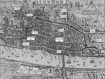
Sixteenth-century London is no doubt the best-known example of these urban dynamics. It grew in population from roughly fifty thousand in 1530 to about two hundred and twenty-five thousand in 1605 (Fig. 2), spurred by London's “combination of economic and political pre-eminence.”Footnote 70 According to Sir Peter Hall, the city saw “a multiplication of wealth and a new habit of conspicuous consumption. . . . [The] new wealth was concentrated into the hands of a trader class and of a speculative aristocracy that clustered around the royal court; together, these groups provided patronage and protection for the artists.”Footnote 71 The implications for theatre were immediate: “[I]n one sense, the question—why did London theatre happen—hardly needs answering: London's theatre arose because the audience was waiting, and the audience was waiting because it was newly rich, albeit well established, and leisured.”Footnote 72
London theatres, ca. 1600. The base map of London was engraved by John Norden in his Speculum Britanniae of 1593. I have added approximate locations of theatres and have outlined the city walls in black. The label “Theatre” marks the location of James Burbage's theatre, built in 1593. Base map duplication photo by Mike Calder; courtesy of the National Library of Sweden.

Cities do more than just call themselves, along with new theatre forms, into being. They also sort themselves into districts and neighborhoods in a manner that has a direct impact on the location of theatres. In ancient Greece and Rome, theatre was an affair of civic and religious significance. Their theatres were conceived of as “civic monuments” and were therefore constructed at great expense in central places of importance.Footnote 73 In Edo during the Tokugawa period (1600–1867), kabuki was wildly popular, though somewhat disreputable; its theatres were restricted to specific districts such as Yoshiwara and Nakabashi.Footnote 74 Alongside the theatres were “teahouses” that provided food and refreshment for theatregoers;Footnote 75 also present were street performers who “recited tales from military epics,” as well as fortune tellers, jugglers, and tightrope walkers.Footnote 76 In Renaissance London, meanwhile, commercial theatre was also somewhat disreputable. While the theatres were (of necessity) easily accessible to urban populations, they were generally located beyond the purview of authorities in the City of London, outside the walls to the north, east, or west of the city; across the Thames in Southwark; or within city walls in church-owned buildings not under the authority of the city.
The final way theatre centers are important is that they have power to organize theatrical activity in areas that can range from the relatively local to entire regions.Footnote 77 As Henri Lefebvre writes, “Carried by the urban fabric, urban society and life penetrate the countryside.”Footnote 78 A major theatre center can be seen as the core of its sphere of influence, secondary theatre centers as semicores (each with its own rather limited sphere of influence), and the rest of the sphere as a periphery.Footnote 79
From the periphery, a core theatre center receives what can crudely be called the “raw materials” of theatre: most important, the potential actors, directors, playwrights, and designers that are necessary for theatrical productions. The core also receives large numbers of people (either as immigrants or visitors) who will serve as audiences for those productions. Finally, there is the indirect (but nonetheless vital) function of the core as repository of the wealth needed to fund productions. In return for these raw materials, core theatre centers provide “finished products” to the areas within their spheres in the form of touring shows, established scripts, polished actors, and so on.
The relationship of core to periphery is often mediated by semicore theatre centers. For example, actors, playwrights, and so forth within the broad sphere of a core's influence might choose to go to a semicore theatrical center to receive the training and experience that will improve their chances in the core. More often than not, though, they will remain in the semicore, perhaps because it is nearer to their homes or perhaps because they are not interested in testing themselves in the core. In return for this raw material, a semicore theatre center will send its own finished product out to its local sphere of influence; it will also occasionally send its finished product (actors, scripts, even full productions) to the core.
The United States provides a good example of how this structure of core, semicore, and periphery works. New York City is obviously the core theatre center of the country, receiving the raw material of actors and so on from throughout the land. In return, it sends out its finished product: touring shows might go on the road, while scripts that have succeeded in New York are performed in the semicore centers and throughout the periphery (in high schools, community theatre groups, and so on). Theatre centers such as Chicago, Los Angeles, and Boston are semicores that have their own, more limited, spheres of influence, drawing in people and sending out (to a limited geographic range) their own shows. Actors and other theatre personnel who have established themselves in these semicore centers might eventually try their luck in New York, and semicore theatre centers might also send their own polished scripts or even their own productions to New York. It might well be that the theatrical dominance of New York has slowed development elsewhere: some of the best local actors will decamp for the big city, while national touring shows can fill a niche that might otherwise have been occupied by major local productions. A similar “development of underdevelopment,” to use a phrase coined by historian Andre Gundar Frank, might be the case with core theatre centers in much of the world.Footnote 80
At the other end of the geographic scale from cities, the megaregion is a unit whose “historical interrelationships and interactions” spill out, if only to a limited degree, beyond regional boundaries.Footnote 81 For well over two thousand years, the various regions of Eurasia (along with North Africa) have been in regular contact with one another, via cross-regional movements of people, commerce, and ideas.Footnote 82 This extensive contact is made possible by what anthropologist Jared Diamond suggests is the directional “axis” of Eurasia. A broad swath of land stretches across Eurasia between 20° and 60° latitude, a band of mostly temperate climates. Crops and farm animals native to any region within these latitudes could be (and were) rather easily diffused across the breadth of Eurasia. As Diamond notes, “By the time of Christ, cereals of Fertile Crescent origin were growing over the 10,000-mile expanse from the Atlantic coast of Ireland to the Pacific coast of Japan.”Footnote 83 People could also move with relative ease across Eurasia, leading to a high level of economic and cultural integration. Everyone knows about the journeys of Marco Polo from Italy to China. Fewer people are familiar with Polo's near-contemporary, Ibn Battuta, who traveled from his home in Tangier on a pilgrimage to Mecca, then visited Persia, India, the Maldive Islands, Ceylon, China, Granada, and Mali. Altogether, Battuta logged an astonishing seventy-three thousand miles in the course of his journeys, roughly equivalent to three times around the world.Footnote 84 One particular effect of cross-regional interactions in Eurasia was the rise of trading cities located at overland crossroads, at fordable points along rivers, and on suitable harbors. These cities often became regional core or semicore theatre centers.
The implications for theatre in Eurasia have been profound. The interregional network of Eurasian cities has provided the material basis for much of the theatre on the landmass. The result is that, despite the irreducible “localness” of individual theatre forms, they share some important likenesses as well. Many of Eurasia's theatre forms are centered in its cities, where large populations and accumulated wealth make extended theatrical seasons possible. The wealth and populations of these cities also encouraged the development of purpose-built theatres. Urban life is also an important reason that many Eurasian forms are literary, even if their texts are not considered to be “literature”; cities, after all, have been the loci of literate classes since the earliest scribes were called on to record the deeds of kings, the holy words of religions, and the mundane but vital details of economic transactions.
For all these reasons, Eurasia can easily be understood to be a theatrical megaregion: that is, a set of regions (Europe, South Asia, East Asia, and so on) that, despite their appreciable differences, share important theatrical traits that are only rarely found elsewhere (at least until recent times). This is an aspect of theatre history that needs further development; Brockett and Hildy discuss the interconnections between European theatre and theatre throughout the rest of Eurasia only briefly and only in the context of the twentieth century. The clear implication is that European theatre was long isolated from theatre in areas beyond Europe. The concept of Eurasia as a megaregion would undermine the exceptionalism of this implication and emphasize how European theatre belongs to the wider expanse of Eurasian theatre.
Although the theatre of this Eurasian megaregion shows extraordinary variety, forms as different from one another as bunraku and European opera share far more traits with one another than with the traditional forms of sub-Saharan Africans or Amerindians. Indeed, it is not surprising (however deplorable it might be) that when Eurasians look beyond their own megaregion, they sometimes claim that neither sub-Saharan Africans nor Amerindians possess any indigenous theatre.Footnote 85 Difference, however, does not imply absence, and there should be no doubt that theatre exists throughout the inhabited world.
The existence of megaregions points up the importance of interregional activity. It is striking, however, in light of all this interregional activity, that the cross-regional transmission of theatre forms seems more difficult than the transmission of commerce or ideas. For example, Indian theatre forms never took root in China, despite continual trade between the two countries and even the transmission of Buddhism.Footnote 86 This might be because theatre forms (like at least some religions, including Hinduism) are profoundly linked to their home societies. Perhaps more likely, it is because there are usually few material or spiritual advantages to be gained by adopting theatre from another culture, limiting any incentive to do so.Footnote 87
Even though theatre forms did not easily cross existing boundaries, at least until the past two centuries, interregional activity (particularly economic activity) has indirectly affected the theatre of the many regions of Eurasia and North Africa, with the various regional complexes responding in their own way to such activity. One of the most notable examples of this indirect but widespread influence began in the sixteenth century. The preceding centuries had been brutal: climatic worsening was followed by the Black Plague, which followed trade routes and killed tens of millions from China to England in the years between 1300 and 1350.Footnote 88 Recovery was painfully slow, but by 1500 or so, a new social order was developing across the megaregion.
Historian Joseph Fletcher has noted a set of interrelated developments that took place across Eurasia, beginning in the sixteenth and seventeenth centuries. These include population growth, a quickening tempo of cross-regional contact, an increase in the number of regional cities and towns, and a growing prominence of major cities.Footnote 89 These developments had a profound impact on theatre, stimulating the emergence of a variety of theatre forms. Many of these forms are still active, including kabuki and bunraku (Japan), kunqu (China), rās līlā and tamāshā (India), and spoken theatre and opera (Europe). It seems most unlikely that this rather sudden emergence of so many new forms is the result of coincidence, especially since the developments observed by Fletcher would be particularly conducive to this theatrical efflorescence.
More recently, from the start of the nineteenth century, interregional contact has increased to such a degree that the entire world has attained an unprecedented, if still incomplete, level of integration. This should probably be seen less as an expansion of European culture per se than as the continuation of a long-term movement toward modernization that, in effect, first passed into Europe from the south and east and then passed out of it into the wider world.Footnote 90 But however we describe it, it seems we are seeing the development of a truly global megaregion.
In terms of theatre, global interactions have also increased. Most noticeable, of course, is the spread of spoken theatre to locales (primarily urban) through much of the world. The theatre of non-European regions, in return, has made an appreciable impact on that of Europe and the neo-Europes; one need only mention the influence of Balinese dance on Artaud, of nōh on Yeats, and of jingju (Beijing opera) on Brecht to hint at that impact.Footnote 91 Still, I would not suggest that regions themselves have lost their distinctiveness to the extent that there is now a single global theatre complex. Despite the spread of spoken theatre, theatre in many regions (particularly outside the largest cities) has only slightly and tangentially become part of a global theatre complex. Although it might well be that in years to come the theatre complexes of all regions will be so fully interwoven as to constitute a single complex, transforming the entire world into a single region, I doubt that such a time has yet arrived.
Conclusion
A fresh consideration of how we might understand the geography of world theatre is both necessary and possible. The necessity lies, above all, in removing Europe from the perceived center of world theatre studies. This does not mean that Europe should be ignored: its theatre not only has a grand tradition but has had a nearly global impact over the past several hundred years. It does mean, however, that we need to avoid viewing the geography of theatre from a perspective that takes these past few centuries as the historical norm—a perspective, moreover, that all too easily encourages the parochial tendency to which all societies are susceptible. World theatre history is not European theatre history writ large. It is not the history of how European theatre has interacted with the theatre of other regions. Finally, it is not the story of European theatre as opposed to theatre elsewhere in the world.
Decentering Europe allows the recognition that European theatre is the theatre of but one region of world, of neither greater nor lesser intrinsic importance than that of any other region. It also means breaking free from the geographic concepts that, intentionally or not, serve to elevate European theatre. The emphasis on continents, with its geographically absurd distinction between Europe and the rest of Eurasia, must go. The emphasis on nations, a type of polity that first came into being in Europe and was consequently foisted (sometimes violently) on the rest of the world, must also go.
Most important, because theatre regions are defined in terms of theatre's geography, they are not beholden to any extraneous concerns. It should not be surprising that theatrically defined regions are often geographically similar to regions defined by other criteria: theatre is deeply imbued in its host societies, which it both enacts and affects. Because theatre regions are based on theatre itself, however, they are far more precise in delineating the continuities and discontinuities of the geographic dimension of world theatre history.
An emphasis on theatre centers, meanwhile, can illuminate how the historical processes underlying theatre history are much the same from place to place, region to region. Theatre develops where people are gathered, whether in permanent urban centers or in centers that are temporarily established when dispersed societies gather together. An influx of people prompts theatrical performance and the development of new forms, whether in London, Edo, Accra, or among the Kwakiutl Amerindians. The active role of theatre centers also helps organize the geography of the theatre center itself as well as of the more extensive territory that it brings within its sphere of influence.
Finally, an awareness of megaregions enables us to see that European theatre is tightly bound within an extensive web of interregional contact. For all of its distinctiveness, it has surprisingly close affiliations with theatre forms as far afield as Japan, sharing important traits with them and moving to the same historical rhythm. European theatre is not a unique human achievement but one of many such achievements. Indeed, theatre itself, wherever it might be found, might best be seen as a single achievement that expresses itself in infinite variety. Reconceptualizing the ways we understand the geographic dimension of that achievement makes possible a far richer appreciation of it.