The territory of Cyrene between 2011 and 2016 (O. Menozzi)
The situation of the monuments and the sites in the territory of Cyrene since 2011 has been changing quickly through the years, even from month to month, and the problems of safeguarding them must not be generalised.
These changes are due to very different reasons: the lack of control and of a police system; insufficient resources and the low number of inspectors at the Department of Antiquities (DoA); the incredible pressure of urbanisation in combination with inadequate building regulations for archaeological areas; as well as, between 2014 and 2015, the arrival of a large amount of people from other parts of the country who are looking for new accommodation and willing to build or enlarge farms and flats.
When the first fighting broke out in Cyrenaica in 2011, fortunately the archaeological sites and finds were soon viewed by archaeologists from the DoA, and colleagues from Libyan universities, as a precious and unique patrimony which therefore needed to be defended. The first military action started on 16–17 February in Cyrenaica, and already by 22 February an official committee of historians, archaeologists and technicians, from both the DoA of Benghazi and the University of Garyounis, was appointed by the Chairman of the DoA, Prof. S. Agab Al Alhasi, to move and save the precious archives of Benghazi's DoA. And by 3 March, this committee had been joined by members of the other DoAs of Cyrenaica and organised into a meeting lasting three days to work uninterruptedly on a common plan for the safeguarding of monuments and museums in the region (Menozzi Reference Menozzi and Santoro2016). This is now a very well-known ‘piece of history’, but it is important to remember these preliminary efforts because they reveal a strong attachment to local cultural heritage.
Just a few days after the beginning of the fighting, the main archaeological materials at risk at Benghazi and Ptolemais were moved to safer sites, and everywhere in the region museums had welded or walled up doors and windows. Moreover, each DoA organised permanent rotas for guarding the sites by alternating their members, technicians, workers, archaeologists and librarians, by monitoring the museums day and night, by patrolling the archaeological sites and by building new temporary fencing where possible. In April the situation was getting calmer in Cyrenaica and the committee was already starting surveys in the territory to map the damage to even the smaller sites and remains, then submitting their official report to the NTS (National Transitional Council). The baladia (municipality) of Shahat (Cyrene) at this stage also supported the DoA in controlling the site of Cyrene during the first problematic months. Thanks to all these efforts since the early stages, the damage to the archaeological patrimony in this preliminary phase was limited throughout Libya; they have certainly been minimal compared with what could have happened during a war. Among the early damage at Cyrene, during the very first days of fighting, there was an attempted robbery, damaging the so-called ‘Mosaic of Orpheus and the Four Seasons’ in the House of Jason Magnus. It was not a direct damage of the war, but while most of the attention was focused on the political and military events, somebody had tried to steal the figurative sections at the corners of the mosaic with the representation of the four seasons. Even though the attempt was unsuccessful, it greatly damaged the splendid mosaic pavement. Another damage from these initial days of conflict, again not directly due to the war but perpetrated when attention was focused on the war and its problems, was the burglary of archaeological materials from the Museum of Apollonia, which was easily opened and robbed for a short time.
The immense necropolis of Cyrene (for general studies, see Cassels Reference Cassels1955; Thorn Reference Thorn2005), which has been intensively surveyed over three seasons (December 2011, July 2012, December 2013) by a joint team of the DoA and Chieti University to map the damage, has already been revealed in these preliminary surveys to have several areas and tombs that were evidently looted (Al Raeid et al. Reference Al Raeid, Di Valerio, Di Antonio, Menozzi, Abdalgader el Mziene and Tamburrino2016; Mziene and Al Raeid Reference Mziene and Al Raeid2015). Robbery and vandalism have always been huge problems for Cyrene and for some of the less controllable sites in the territory.
Obviously the core area of the site presents fewer problems than the territory around it, because of both closer control and the fences that still block looting, although not vandalism. The fences act mainly as a psychological rather than real barrier; for most of the local people, everything within the fences is seen as ‘more important’ than what is outside. Immediately this view creates initial problems, because it is impossible to contain within fences the thousands of monumental tombs found at the necropolis, or the rock-cut sanctuaries and ancient farms.
Since 2014, because of the unstable local situation, it has been impossible to organise more seasons for Chieti's team, so we have started a programme of remote sensing in collaboration with the local technicians of the DoA (Abdalrahim et al. Reference Abdalrahim Sheriff Saad, Farag Abdel Hati, Antonelli, Menozzi, Petraccia and Somma2016; Menozzi, Di Antonio and Di Valerio Reference Menozzi, Di Antonio and Di Valerio2015; Mziene and Al Raeid Reference Mziene and Al Raeid2015; Petraccia et al. Reference Petraccia, Abdalrahim and Abdel Hati2015) in order to test a common protocol for documenting the sites already showing issues, for both directly and remotely monitoring the sites through the analysis of satellite images and through the surveys of the sites presenting changes in the landscape and markers of damage.
The typologies of risk for this ‘neglected’ patrimony in the territory are very different. The first and foremost typology of damage is certainly due to looting, which has always been a problem for the funerary areas of Cyrenaica, increasing in recent years, and in the 2014–15 period it became worse and worse. The large number of sculptures from Cyrene appearing on the black market, mainly including statues of Cyrenaican funerary goddesses and Romano-Libyan portraits, come from the necropolis (see Belzic, this volume).
Acts of vandalism are another great problem and present different degrees of damage from charcoal writing and graffiti to the partial or total destruction of a monument, and in this second case there is a fundamental ideological purpose to the vandalism: acts of protest or extremism. For an example of the destruction in the territory of Cyrene, this was the case for two marabout monuments, the Bu Bagiouda monument in the southern necropolis and the Marabout at Sambar, in the terrace just below Cyrene. It happened between 2014 and 2015, when the occurrence of extremist raids, probably coming from Derna, is attested.
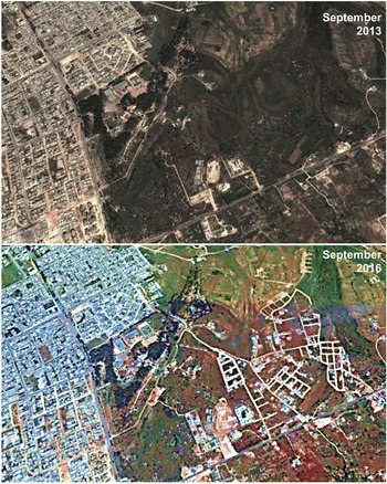
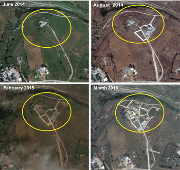
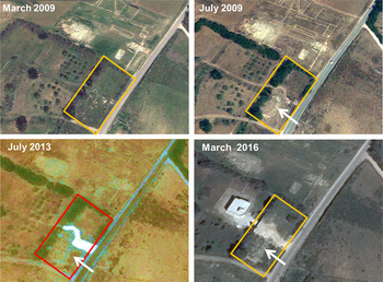
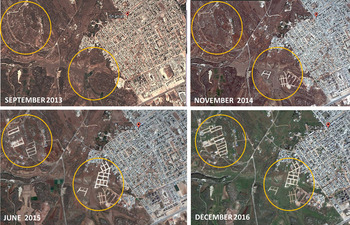
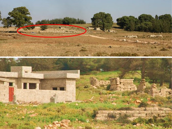
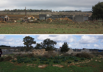
The lack of regulation and of police control, combined with urban pressure, has also brought about a large amount of uncontrolled building and the unplanned and untamed urbanisation of the territory. Urban pressure has always been a problem for Cyrene and in the development of modern Shahat in the 1980s and ’90s most of the southern necropolis was obliterated and ‘sacrificed’. This phenomenon has been increasing enormously in the last three years, bringing about the destruction of large sections of the necropolis, as in the case of the eastern necropolis (Tamburrino in Al Raeid et al. Reference Al Raeid, Di Valerio, Di Antonio, Menozzi, Abdalgader el Mziene and Tamburrino2016, 18–28). New farms, living quarters and flats have been planned and are in progress in several areas containing monumental funerary remains, and the first act is always to ‘regularise’ the area by ‘bulldozing’ the monuments and to demarcate the road system. Several examples can be shown, as in the case of the area of El Darb (Figure 1) in the eastern necropolis, or the area of Baggara, where it even happened close to the monumental Sanctuary of Demeter (Figure 2). In some cases, as in the western section of the southern necropolis, some of the monuments have been used as quarries to find building materials.
Shahat-Cyrene, eastern necropolis area of El Darb section: satellite views of the area showing the progression of the urbanisation.

Shahat-Cyrene, El Baggara hilltop to the north-west of the Sanctuary of Demeter: shots showing the opening of new roads and new quarters.

Specifically for monitoring and documenting this typology of damage, the team of Chieti University is testing a protocol of intervention in collaboration with technicians and inspectors from the DoA. The first step of this protocol is the remote monitoring of the territory of Cyrene through photo-interpretation and filtering of different kinds of satellite imagery, based on the aims of the remote sensing (Abdalrahim et al. Reference Abdalrahim Sheriff Saad, Farag Abdel Hati, Antonelli, Menozzi, Petraccia and Somma2016). Obviously for the geomorphological and regional studies shots coming from Landsat-Zulu datasets are used,Footnote 1 and for territorial research studies different typologies of high-resolution satellite imagery such as IkonosFootnote 2 and Quick BirdFootnote 3 sets are employed. However, for monitoring changes in the landscape and the aggressions against monumental areas, the satellite bases already mentioned for the previous steps have then been compared with more recent satellite shots coming from different sourcesFootnote 4 and new HD panchromatic satellite setsFootnote 5 in order to identify the typologies and the degree of risk to the sites, and then field surveyors are sent to investigate how to limit the damage. In fact, at this point what has been extremely important is the interaction with local technicians and inspectors, who were already working with our team in surveying the territory of Cyrene and were also trained in Libya and in Italy specifically for this type of monitoring. Some of the results of this work by the Libyo-Italian team monitoring different areas have been published recently (Abdalrahim et al. Reference Abdalrahim Sheriff Saad, Farag Abdel Hati, Antonelli, Menozzi, Petraccia and Somma2016; Al Raeid et al. Reference Al Raeid, Di Valerio, Di Antonio, Menozzi, Abdalgader el Mziene and Tamburrino2016; Mziene and Al Raeid Reference Mziene and Al Raeid2015; Petraccia et al. Reference Petraccia, Abdalrahim and Abdel Hati2015).
Moreover, another important typology of risk, which is less evident and so almost neglected, is the damaging of the monuments caused by the lack of a system of maintenance, which causes the deterioration and cracking of the surface of the local limestone, the increase in bushes and trees (which heavily damage the monuments), the proliferation of micro-biodeteriogen elements (mosses, lichens, algae and fungi), often causing detachments in paintings and stuccoes but also attacking the superficial patina and exposing the softer layers of the limestone to the rooting and to capillary water seepage and humidity (Al Raeid et al. Reference Al Raeid, Di Valerio, Di Antonio, Menozzi, Abdalgader el Mziene and Tamburrino2016; Menozzi and Tamburrino Reference Menozzi and Tamburrino2012). Because the wider damage causes a great and direct visual impact, we tend to forget about the risks of the lack of maintenance, but these can be even more dangerous in some cases, especially when involving very monumental buildings which are only apparently stable but actually fragile for static reasons. This could be the case of the portico of the gymnasium, which is dangerously damaged in the north-eastern corner by the complete lack of maintenance of the old iron restorations, which have then cracked the blocks and compromised the static balance of the architraves.
In order to help with the problem of maintenance and restoration of the sites, an agreement between the DoA (Dr Ahmed Hussein Abdulkerim) and some of the Italian missions working in Libya (from the Universities of Urbino, Chieti, Roma 3, Naples 2 and the Mission of the MIBACT at Giarabub) was established and it is now showing very interesting results. A course on ‘Rescue restoration in emergency’ was organised in November and December 2016 dedicated to the restoration of the architectonic and sculptural elements in limestone (see Appendix I for details). Training is intended to be articulated across several courses of 5–8 weeks for Libyan restorers and inspectors; they are coming to Italy because at the moment the situation in Libya does not allow access to the sites, but when the situation becomes calmer, it is planned that the training will be concluded with a practical part taking place in Cyrene. For the first course, both the theory lectures and practical training have been done in Italy, with courses in Chieti and Urbino, by restoring a statue and some architectonic elements specifically chosen on the basis of the geological composition of the materials, which are similar to what is found in Cyrene. During the training, the trainees have also been sent to Pompeii and Rome to analyse sample cases, with visits to both monuments now under restoration and laboratories (see Appendix I).
Certainly it is clear that the local office of the DoA has now (from the end of 2016) increased the number of its inspectors and technicians, which is already a good start. However, only close interaction between different institutions, either locally (such as the DoA, the universities, baladia and cultural associations) or with foreign partners (such as the archaeological missions, UNESCO and ICCROM), can help to safeguard this monumental patrimony, and only if it is done in close collaboration, supporting the creation of local teams to be trained in different fields.
During the preliminary surveys in 2011 and 2012, several damages were mapped, caused mainly by looting in the remote sections of the necropolis, but, as mentioned above, robbery and damage to uncontrolled sites or monuments has always been a big problem for Libyan archaeological heritage, especially because the young generations do not care too much about their own past and too often archaeology has been seen by them as an obstacle to new buildings or as a source for illegal gain by selling ancient statues, pottery and coins across the Egyptian border and on the black market.
In a new and peaceful Libya, more widespread information and the education of children and the youth on the history and treasures of this splendid country could certainly help in creating a new sense of pride in their cultural patrimony, starting mainly with the youngest generations; they, in fact, will soon become the new Libyans, who should care more about their cultural heritage, which must include, in its wider definition, not only archaeological sites and finds, but also the architectonic patrimony of every period, the natural resources (such as wild parks and widian, which are particularly defined in Libya), as well as the non-physical and the anthropological patrimony, such as oral literature, music and poetry.
In this sense, it must be mentioned that, for Cyrene, a very good attempt has been made since the end of 2012/beginning of 2013 by a small but effective group of archaeologists and inspectors – namely, Ahmed Aissa, Abdalrahim Shariff and Said el Alnabe – who started with lectures in the schools to educate children about their history and explain their cultural heritage, trying to enthuse them with stories, guided tours to the site and even small improvised excavations.
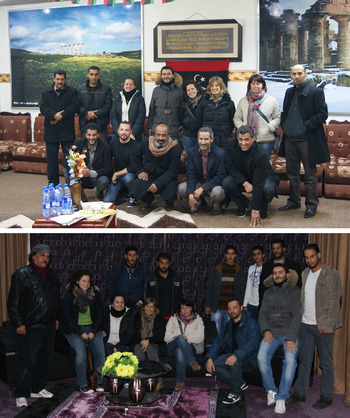
In 2013 particularly fruitful has been the collaboration between the DoA of Cyrene, the baladia and the local Association for Culture and Media, which organised meetings with the missions in order to help and support in specific situations. In particular the mission of Chieti University was invited in 2013 (Figure 3) to present on the problems of the area of Ain Hofra, because the DoA and the Association for Culture and Media were trying to support the building of fences or organise a system for guarding this area, which is quite remote and difficult to control. (On the damage to the area of Ain Hofra, see the section below.)
Shahat, photos of the meeting with the Cyrene Association for Culture and Media and with members of the DoA.

Although the number of inspectors and technicians is slowly increasing in Cyrene, it is certainly inadequate for the monumentality of the site and the extent of its territory: not only are archaeologists lacking, but guards for the sites and restorers to undertake emergency restoration and maintenance of the monuments. Thus especially the necropolis, owing to its vastness and its difficult geomorphology, has suffered from the lack of control.
Moreover, the lack of skilled and technical staff has also brought about an ‘abandonment’ of the territory; not enough inspectors and technicians monitored this large territory, which is so rich in a myriad of monumental basilicas, fortifications (gsur), ancient rural sites and villages.
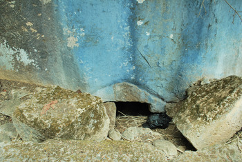
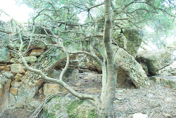
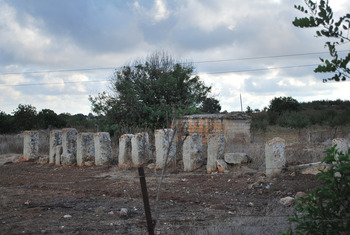
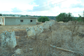
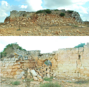
During the 2012 and 2013 seasons, a joint team of Chieti and Macerata Universities, together with the inspectors of the DoA, Farag Abdel Hati and Abdalrahim Shariff, visited several sites to the west and to the east of Cyrene, and have continued to map and document the situation since then. After the surveys, we continued the monitoring of the sites through remote sensing of the surveyed areas and by sending, when and where necessary, our Libyan colleagues to directly control the site. The survey has allowed us to classify the damage and the urgent needs in the transect to the west of Cyrene, where the sites surveyed included Alot/Eluet Jalta (Figures 4–6), El Groppa (Figures 7–8), Targhunia (Figure 9) and Gasr Nuwarah (Figure 10), in the area of Messa. Funerary monuments (Figures 4–6), mainly chamber tombs with large courtyards and sarcophagi, characterise the sites of Alot/Eluet Jalta, attesting quite a wide chronological range, from the Hellenistic to the late Roman periods; in fact a later building (a fortified basilica or storeroom) is also attested (Figure 6). The area of El Groppa presents, again, several funerary monuments, but also the remains of the ancient road network, mainly attested by a long row of orthostats (parallelepiped stones used as cippoi; Figures 7–8) for marking the road and the limits of the agricultural plots; the tombs (Figure 7) attested seem to be mainly characterised by Hellenistic temple tombs.
Alot/Eluet Jalta: the courtyard of a tomb, which has then reused in later periods.

Alot/Eluet Jalta: the entrance of a chamber tomb.

Alot/Eluet Jalta: remains of the arches supporting a fortified building.

Messa/Massah, El Groppa: view of one of the temple tombs and of the alignment of orthostats (vertical parallelepiped stones).

Messa/Massah, El Groppa: view of the alignment of the orthostats close to the modern farm.

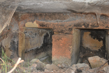
Targhunia/Targuni: inner view of the loculi in one of the hypogeal tombs.

Gasr Nuwarah: the large fortified building.

The area of Targhunia, or Targuni (Figure 9), has been mentioned briefly in the studies regarding the presence of a settlement and a possible rock-cut church with the remains of paintings and regarding an incision representing two peacocks on a block, suggesting Christian use of this context (Kenrick Reference Kenrick2013, 140; Ward Perkins and Goodchild Reference Ward-Perkins, Goodchild and Reynolds2003, 417). The surveys have shown that it is quite a broad site, probably a small village with an agricultural vocation. Several tombs have been found along with a large courtyard with loculi, a series of sarcophagi, several remains of an ancient road network, simpler burials and signs of quarrying. These three sites (Alot/Eluet Jalta, El Groppa and Targhunia), all of them not far from Messa, are totally unexplored and certainly could be useful to understanding the local exploitation of resources and the role of the minor settlements and villages in the western section of the territory of Cyrene; with the survey we have documented that they have been violated and damaged by illegal excavations and looting.
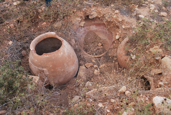
A fourth site, known as Gasr Nuwarah (Kenrick Reference Kenrick2013, 140), presents the monumental remains of a large fortified building, which seems to have been closely related to a productive area with large cisterns and a storeroom with several dolia still preserved, probably dating to the Roman and late Roman periods (Figures 10–11). The site is closely related to a large modern farm, which has not affected the site, but could be problematic for future survey enlargements.
Gasr Nuwarah: some of the dolia in a possible ancient storeroom after clandestine excavations.

Already during the surveys of 2012 and 2013 in general the area of Messa/Massah presented several cases of damage caused by the construction of buildings or the enlargement of existing farms, but the situation became worse and worse between the spring of 2014 and the summer of 2015. For instance, probably in 2015, a dreadful situation for the western area occurred, particularly to the area of Messa/Massah, where one of the most ancient circular tombs known as the ‘Tumuls of Messa’ was completely destroyed during works to enlarge the nearby farm.
The area to the east of Cyrene presented during the surveys of 2012 and 2013 quite a good situation for Lamluda (on the site, see Menozzi Reference Menozzi and Ensoli2012; Menozzi et al. Reference Menozzi, Fossataro and Somma2010; Menozzi et al. Reference Menozzi, Antonelli, Cinalli, Mancini and Agostini2014). The core of the site, relating to the ancient settlement, did not show damage because of the fencing in place and also because of an agreement between the DoA and the owner of the land, who also guards the site. However, the funerary monuments (32.47.098N-22.9.188E) just outside the settlement have been heavily damaged and already by 2012 they had been included within private farms and houses and partially covered by modern buildings. Today the section of the necropolis to the north of Lamluda is at risk from building works.
Similarly, Gabu Younes/Quabu Younis (Kenrick Reference Kenrick2013, 309) does not show damage inside the fences, and because the site has never been excavated it is therefore more difficult for robbers to identify specific buildings that are rich in sculptures and decorations. However, the expansion of the modern road and the construction of houses nearby are ‘silently’ destroying the funerary areas of this settlement.
Even Jebbra/Jubbra/Jibrah and Mgerne/Mqayrnis, although quite well-preserved sites, because of their large extent and of their remote location are in danger from looting and the construction of new farms around the sites.
Going back to the necropolis of Cyrene, looting and damage due to building works have always been a problem for the necropolis, but certainly from 2011 the lack of control caused these issues to increase, reaching maximum intensity between 2014 and 2015. It is even possible to point out which sections of the necropolis were affected by these problems and when. For instance, the western necropolis was already showing problems in 2011 and 2012, with damage mainly due to random looting. In 2013 a more systematic and serious series of damage is attested for the area of El Darb (Figure 1), in the eastern necropolis, where new buildings have been planned, so new roads have been opened by ‘bulldozing’ the tombs, robbing everything inside them, to then sell the finds from these illegal excavations on the black market.
In addition, by monitoring the areas where the team of Chieti University is excavating, we have also noticed that in the last three years the Tomb S1 in the southern necropolis is at enormous risk from the building works nearby (Figure 12): a large road has been recently opened and a new farm has also been built.
Shahat-Cyrene, southern necropolis: views of the area of the monumental tombs at S1 (in the square), showing the construction of a large road and a farm damaging part of the structure.

Moreover, between 2014 and 2015 the western area of the southern necropolis (Figure 13) experienced an increase in building works, also causing damage here from the opening of new roads and a great deal of robbery.
Shahat-Cyrene, southern necropolis: satellite shots of the western section of the southern necropolis showing the growth of the new quarters of modern Shahat.

Comparing the dates of the appearance of Cyrenaican statues and finds on the black market, it should be possible in some cases to hypothesise the original contexts of these finds, if not the precise tomb then at least the area.
The long and systematic mapping and remote sensing of the necropolis has already produced a series of reports, which in some cases have been presented in Libyan Studies (Al Raeid et al. Reference Al Raeid, Di Valerio, Di Antonio, Menozzi, Abdalgader el Mziene and Tamburrino2016) and in Libya Antiqua (Menozzi et al. Reference Menozzi, Di Antonio and Di Valerio2015; Mziene and Al Raeid Reference Mziene and Al Raeid2015; Petraccia et al. Reference Petraccia, Abdalrahim and Abdel Hati2015; Tamburrino Reference Tamburrino2015).
We therefore discuss here only those areas of the necropolis that have not yet been presented in other papers.
The damage to the western necropolis: Baggara and Aleg Stawat (E. Di Valerio)
As part of the GIS project of the necropolis of Cyrene, the western necropolis has also been widely mapped and surveyed, and also carefully monitored through surveys and remote monitoring on satellite images.
During the surveys of 2012 and 2013, a large section of the western necropolis was surveyed, including the area of Baggara, the slope of Wadi Belghadir and the area of Aleg Stawat, where an ancient road forked towards Budrag and towards Wadi Arabiyah to reach the coast.
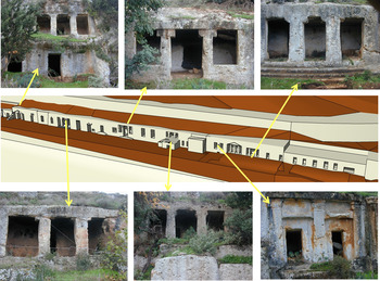
The area is extremely interesting from an archaeological point of view owing to the presence of a long series of rock-cut tombs, quite monumental, dating from the Archaic period to the second and third centuries AD, which were regularly positioned along the ancient road (Figure 14). The most monumental out of this long series of tombs are 15 monuments with a homogeneous building project, with similar facades decorated with orientalising acroteria, dating to between the sixth and the beginning of the fifth century BC. Not far from these tombs are also located W16 and W20, which are famous for their Doric painted friezes.
Shahat-Cyrene, western necropolis: 3D and views of the ancient roads with rupestrian tombs on the eastern slope of Baggara Hill (3D by E. Di Valerio).

In this nice section of the western necropolis, which was documented by Pacho in 1827 for its beauty, several recent damages have been found, due to both anthropogenic and natural agents. Initial problems here are the weathering agents and the growth of the trees, whose roots often destroy sections of the facades or parts of the monuments. Other damage was due to the intense frequentation of these tombs for picnics, often leaving litter and graffiti, and also causing the blackening of the walls from the smoke of the fires. Looting is also widely attested here, showing signs of both old lootings and very recent ones. Despite its closeness to the modern town and farms, the remote location of this section of the necropolis, mainly due to the topography of the area, allows robbers and vandals to stay longer without being seen from the roads or houses. However, because of the difficulty of transporting heavy finds along the steep slopes, most of the statues are left mutilated with just the heads cut off and transported outside Libya to be sold abroad.
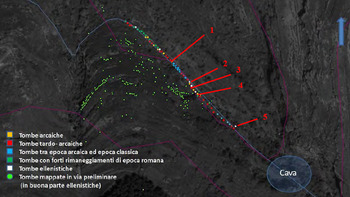
For the area of Aleg Stawat the surveys have been important in identifying and quantifying the damage caused exclusively by grave robbers and illegal excavations. In general the conditions of the tombs in this section of the western necropolis are not affected by roots and bushes, because of the lack of vegetation; the only damage is caused by looting. There are frequent illegal excavations (Figure 15) in the courtyards of the tombs and especially inside the funerary chambers, destroying the stratigraphy, the architectonic blocks and decorations of the tombs. Certainly pieces of the funerary equipment, statues and friezes have been stolen. It's not possible to quantify the real extent of the damage; in any case, the grave robbers have irreversibly destroyed a part of the archaeological heritage of Cyrene.
Shahat-Cyrene, western necropolis: GIS of the ancient roads with rupestrian tombs on the eastern slope of Baggara Hill and indicating the main area affected by looting (E. Di Valerio).

The illegal excavations have impacted the most remarkable tombs, and in particular the loculi tombs unfortunately not yet investigated archaeologically.
A funerary statue from Aleg Stawat? (O. Menozzi)
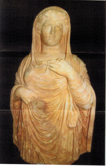
It has been hypothesised that a statue recovered from the black market in 2012 comes from one of the tombs of Aleg Stawat. In 2012, in fact, the DoA of Tripoli and Cyrene (under chairman Dr S. Agab el Alhasi) together with the foreign missions of Chieti and Oberleen initiated the recovery of a complete sculpture of a so-called ‘funerary goddess’ from Cyrene, which appeared on sale on the French market (Figure 17). It was realised in fine white marble and certainly came from a Greek quarry, as did most of the Cyrenaican funerary goddesses. This kind of marble in antiquity came in rough pieces from Paros, Naxos and Attica (such as Penthelicus and Hymettus), and then sculpted at Cyrene by local workshops, and this sort of sculpture is widely attested in the necropolis of Cyrene. Moreover, these local workshops and artisans are easily identifiable, not only from the typology of statue, but also from the hairstyle of the statue and the position of the arms and hands (Beschi Reference Beschi1969–70; Chamoux Reference Chamoux1953; Ferri Reference Ferri1929; Siciliano Reference Siciliano, Fabbricotti and Menozzi2006; and see Belzic, this volume).
The thin red patina on the surface soon attested that it was a recent looting; the patina came from the chemical link between the external section of the marble patina and the oxidation of the red Cyrenaican soil, which has a reddish colour owing to its richness in iron. The typology of the statue, as typical of the so-called Cyrenaican ‘funerary goddesses’, is characterised by a standing female figure, as usual sculpted just on the upper part of the figure and cut just below the hips. The female figure is wearing a softly wrinkled chiton, which is always covered by a large, soft himation (mantle) covering part of the body, with both head and shoulders showing the typical Greek iconography of the veiled figure. Both arms are flexed, with the right arm placed just below the breast and the left arm uncovering the face from the himation in a gesture typically known as anacalypsis, that is the ritual uncovering of the face, reminding us of the passage between life and death.
These statues were largely used at Cyrene as markers of the tombs, representing initially (in the early Archaic period) female chtonian aprosope goddesses, which helped the dead in their passage between life and death; from classical times, this goddess represented syncretism, assimilating Demeter and Persephone/Kore.
According to the typologies of Beschi (Reference Beschi1969–70), who studied the numerous funerary goddesses from Cyrene, this statue can be dated to the Hellenistic period and precisely to the end of the fourth and first half of the third century BC.
About the possible provenance, it is clear that the statue comes from the large necropolis of Cyrene; in particular, this typology of statue almost certainly comes from the typology of tombs known as a monumental rock-cut loculi tomb facade, and this kind of statue, together with inscriptions and other markers, was generally located on the top of the architraves. Generally from this original position, these statues were falling down in antiquity just in front of the tombs and often were then buried for centuries until they were clandestinely excavated by tombaroli (looters). A huge number of examples of these thefts are presented in this volume by Morgan Belzic (see below), who is contributing enormously to the recognition and recovery of this patrimony.
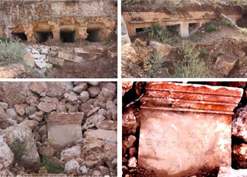
In the particular case of this first statue which was found on the French market, there is a fortunate connection to the survey in 2012 of the tombs at Aleg Stawat, which were clandestinely excavated and robbed in that period. In particular, it could be hypothesised that a specific tomb on the medium terrace of the western slope of Aleg Stawat could plausibly be the original context of the statue. The survey in 2012 was able to show not only that this tomb had been looted recently, but also that something quite large had been removed, possibly something of about 150 cm h. × 80/100 l. × 60 cm (a funerary goddess statue seems to fit perfectly in this hole). Just below the removed and stolen piece (Figure 16), many blocks and a possible fragment of a base of a funerary statue were still visible, and also a stele with an inscription was still there; it was then removed by the members of the DoA in order to preserve it.
Shahat-Cyrene, western necropolis: some of the tombs which have been looted in the area of Aleg Stawat. The two images below show the tomb where fragments of a base for a funerary statue and a stele with a Greek inscription have been found.

The statue which was found on sale in Paris (photo by S. Agab el Alhasi).

The Greek inscription (Figure 16) attests the name of the person who was buried there, Aristis Euricrateus, all in capital letters. The inscription is quite regularly organised and centred on the epigraphic area, although not following precise lines, and it is written in thin lettering. The stele is realised in the same Greek marble of the statue mentioned above, which is now in Paris. Moreover, the mouldings in the upper part of the stele certainly date to the Hellenistic period, showing a second common feature with the statue. The dating of the stele, as for the statue, is the period between the end of the fourth and the first quarter of the second century BC.
Damage to the area of Ain Hofra (E. Di Valerio)
The area of Ain Hofra, although very close to Shahat, is quite remote and since 2010 vandalism and looting have started at the site, probably because the archaeological area has been seen as a possible impediment to urban expansion and building works. From the archaeological point of view, the area is very interesting owing to an early Greek rock-cut sanctuary (an heroon with necromantic cults: Menozzi Reference Menozzi2015) and to the monumental Hellenistic and Roman funerary areas. The upper plateau, just above the alek of the wadi (that is, the beginning of the canyon), presents very monumental buildings, not all of them excavated. A large Hellenistic tomb with a semi-hypogeal courtyard and a false facade in ashlar masonry, which has been named Tomb B, has only been mapped but never excavated, for instance. This monumental complex is also characterised by a small temple tomb (which has been named Tomb D), where just the basement has been preserved. But the most spectacular and monumental buildings are Tombs A and B, which are large Roman temple tombs built to a rectangular plan, with an axial focus meant to emphasise the funerary chamber (sepulcrum) in the back rooms. The architectonic features and decorations and the magnificence of these two tombs attest to the owners’ appurtenances of the upper classes of Roman Cyrene, with a strong message of social class. Both tombs had marble decorations and statues, as well as very fine examples of Attic sarcophagi dating to the second century AD (Fabbricotti Reference Fabbricotti, Menozzi, Fossataro and Di Marzio2008).
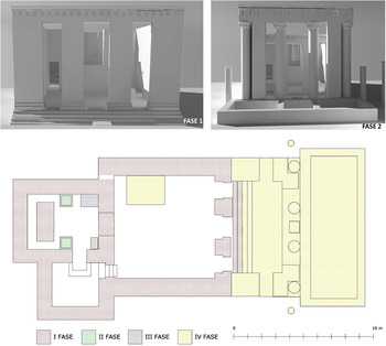
In the recent problematic years for Cyrene, Tomb A (also named the ‘Tomb of the Sarcophagi’) and Tomb C (the ‘Tomb of the Sculptures’) have been heavily damaged, mainly through vandalism. In Tomb C, the blocks relating to the walls and to the architectonic friezes, which had been organised and catalogued inside the tomb and prepared for restoration, because they were ready for consolidation and anastylosis, have been broken and heavily damaged and then reused in modern terrace walls and fences in the area. This series of tombs was quite monumental and well preserved. The two large temple tombs (A and C) dating to the second century AD, are quite elaborate in their architectonic style and present rectangular temples with two main rooms and a portico; the main burials were located in the back rooms, but always visible even from outside the tomb. Tomb C is slightly later than Tomb A, but repeats its planimetric model in a larger and more monumental version. For Tomb C, thanks to the study of the architectonic elements, which were quite well preserved, it has been possible to reconstruct the original appearance of the monument, its volumetric aspect and its decorative apparatus (Figure 18). Both tombs were built employing large blocks of local limestone, which were laid on both the long and the short sides. The external facade presented a tetrastyle pronaos, which was emphasised in the case of Tomb C by the construction of a basin or pool for decorative purposes, and the water would have reflected the columns, giving the facade an even more monumental and slender appearance.
3D reconstruction and plan of Tomb C at Ain Hofra (E. Di Valerio).

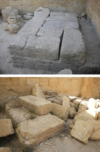
In both Tomb A and C, the large podium of the lateral sarcophagi have been completely dismounted (Figure 19), probably through looting and in the search for more marble and sculptures to sell.
Shahat-Cyrene, Ain Hofra: the podium of the antechamber in Tomb C, before and after the damages.

Tomb B (the courtyard, late Hellenistic, tomb with a false facade located to the west of the two Roman temple tombs, which has never been excavated, only mapped) has now been completely obliterated and covered by a large open terrace, probably preparing the area for the construction of a new house.
Tomb D (the late Hellenistic small temple tomb, just to the west of Tombs A and B) has been erased in order to open a new road between two private lands.
The damage in this case is not limited to the looting of the tombs, but the vandalism and destruction must be due to the intent to build new farms and houses in this area, particularly beautiful for its spectacular view overlooking the lower terraces of the jebel and for its wild natural context.
El Darb and the western new Shahat: two areas of new expansion in the eastern and southern necropolis (C. Tamburrino)
The area of El Darb represents the mid section of the eastern necropolis and before 2013 it was almost totally wild, with just a few farms among several tombs. The area, until 2013, still preserved part of the ancient road network, enough to give the place its name, which means ‘the road’. It is a flat area and therefore, with a large number of temple tombs and monumental circular tombs, mostly dates to the Hellenistic and Roman periods. Because the territory was flat and fertile, the area in antiquity was largely used for agricultural purposes, and in some cases it has been possible to reconstruct the organisation of the ancient kleroi (rural plots), and the land markers were still preserved until 2013, as already mentioned in previous reports (Al Raeid et al. Reference Al Raeid, Di Valerio, Di Antonio, Menozzi, Abdalgader el Mziene and Tamburrino2016; Menozzi Reference Menozzi and Luni2010). The unplanned urbanisation of this area started from the spring of 2013, but with the strongest destructive periods between the summer 2014 and the 2015 (Figure 1) when a sort of road network was prepared by bulldozing and regularising the area, and these roads played the role of a grid or skeleton for the new quarters.
At this point, most of the numerous orthostats (stones which were used in antiquity as markers of both the ancient road network and the rural organisation of the territory) have been removed or even reused as building materials (Figure 21).
Most of the monuments in this area are represented by temple tombs, which are characterised by quite elaborate architectonic features, such as Ionic kyma, Doric friezes or entablatures, and Cyrenaican antae. Some of these temple tombs (which were particularly numerous in this context and date to the late Hellenistic and Roman periods) have been included within private gardens, or destroyed because they obstructed the passage of the bulldozers and the positioning of modern fences and buildings. The blocks in some cases have been removed, reused, or just stacked nearby in order to free up as much space as possible for the new farms and houses (Figures 20–21).
Shahat-Cyrene, eastern necropolis: the new houses which have been built on tombs and on an alignment of orthostats in the area of El Darb (photo above: before the construction).

Shahat-Cyrene, eastern necropolis, area of El Darb: the destruction of some of the small temple tombs (above) and the construction of a farm destroying half of a monumental circular tomb (below).

The circular tombs are attested mainly in a monumental version, with masonry of large blocks for the tholos and, in some cases, with low quadrangular base (such as tomb E121: Siciliano Reference Siciliano, Fabbricotti and Menozzi2006), but earlier tumuli may not be excluded. However, most of them have been heavily damaged, at times partially covered, or totally destroyed (Figure 21).
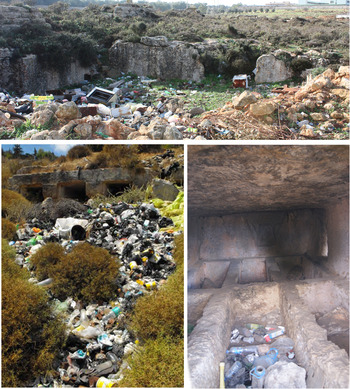
There are also hypogeal rock-cut tombs, mainly characterised by squared courtyards with chamber tombs or loculi on two or three sides. In the case of these tombs, a long series of ‘reuses’ already occurred in antiquity, especially in late Roman and Byzantine times, when they were used as quarries, cisterns, storerooms or even shelters in more recent times. This diachronic and multifunctional feature of these tombs is certainly one of the most interesting aspects in reconstructing the long life and evolution of these monuments. With the works for the new quarters, some of the tombs became a sort of rubbish tip for building materials (Figure 22), but this is a problem also affecting other sections of the necropolis, especially in the north necropolis (Figure 22). In other cases, these tombs have been covered by buildings or used as underground floors for new houses, a sort of ‘monumental cellar’!
Shahat-Cyrene: views of tombs which are used as rubbish tips in the eastern (above) and in the northern (below) necropolis.

Another problematic area in terms of damage to the ancient monuments of the necropolis is the area of urban expansion to the west of modern Shahat. Already by the end of 2013 (Figure 13) several building works had started to destroy the ancient remains in the area, even with the ‘removal’ of some of the monuments using the bulldozer's bucket. At the beginning, just large houses with gardens were built, and some of the ancient remains were included within the compounds, becoming part of these ‘private properties’. This forced ‘privatisation’ of cultural patrimony has also led to an increase in illegal excavations within these properties, which were perpetrated just behind the high walls surrounding the properties, and therefore quite unnoticeably. In 2014 and 2015 (Figure 22), the situation grew worse and more flats and houses were built, more roads were opened, with terrible consequences for this section of the southern necropolis.
Conclusions (O. Menozzi)
It seems to be obvious that the differentiation of the damage throughout the territory and the necropolis attests different typologies and degrees of risk, which must be carefully analysed and documented in order to prevent more damage.
Documentation of the monuments as well as of the risks and of the damages is, at the moment, the only way to preserve the memory of monuments and sites which could be lost forever. The progression of the damage attests the different typologies of attack during the period 2011–16, which must not be generalised and simplistically attributed to just urban development. We have mentioned how different the reasons were, and how problematic the lack of rules has been, and the lack of police control as well as inspectors and technicians for the territorial offices.
The apex of the problem was certainly between 2014 and 2015, when a large number of people started arriving from the coastal areas (Derna, Benghazi and similar); they were trying to escape areas with a large extremist presence and fighting. In this period, the attention was focused on survival problems and the already poor control of the territory has been completely forgotten.
It must also be considered how difficult it has been for the local offices of the DoA to survive in the years between 2014 and 2015 without resources, with great difficulties in those years with communications, as well as extremist raids coming from the coast. However, the few inspectors and guards have done their best. Obviously, often it has been impossible to contrast new buildings with abusive buildings without any support of the police and without any regulatory system or rules.
In 2016, although there are still large problems, there seem to be slight improvements. The number of restorers, archaeologists and technicians has been improved by the DoA, and these new inspectors now need to be trained for a more fruitful job in defending this wide territory.
The building of new houses is slowly calming down, and it is easier for the inspectors to talk with the owners of the land to check the archaeology of places before the start of new constructions. It is not always easy, and sometimes the owners are still ‘shooting’ against the archaeologists, but it is a start!
Probably new rules and new laws must be organised to support the local offices in monitoring the progress of urbanisation, as well as to stop the building work to enable excavation and documentation before starting construction. In addition, the attitude of local institutions must change, starting a more collaborative era among local offices and their branches, contributing together to preservation and a more sustainable urban growth. But again, it is too easy from the outside to point out issues and solutions; all of this needs a new legal system, a specifically trained police corps, and mainly it needs economic resources and time!
Appendix I: Interim report of the first course in ‘Rescue restoration in emergency: architectonic and sculptural elements in limestone’ (S. Abdulrahim Shariff)
This paper is the preliminary report of the training course in archaeological restoration and maintenance which has been organised by the Archaeological Missions of Chieti, Urbino, Roma 3 Universities and the Ministero Italiano dei Beni e delle Attività Culturali e del Turismo. The course was held in Italy in November and December 2016. This first course was part of a larger programme planned by these Italian Missions with the DoA in order to send abroad for training about four or five restorers or inspectors, to be trained in different fields concerning restoration of the monuments and maintenance of the archaeological sites. Four persons participated in this first course (Saleh Belqasem Ibrahim, Tareq Salahuldeen Ahmed, Nuri Mahmoud Belqasem and Abdulrahim Saleh Shariff).
The course started by acquainting the students with classical history and architectural theory relating to the types of building stones and marbles specifically used in Cyrene. The typologies of buildings and of architectonic elements were studied and the trainees were involved thanks to the use of cases that they knew already.
Some of the lectures covered the issues and damage that might occur in specific cases in Cyrene, due to both environmental factors, such as the deterioration of old restoration, and possible mistakes in restoring the monuments and to biodeteriogens, which are often not visible but may greatly affect the monuments.
The building materials discussed during the lectures, both concerning architecture as well as damages and risks, were the same type of limestone and sandstone blocks used in Libya. This step was important because we could see the different results and risks caused by the different building materials, including the main issues that might be encountered in Libya on the basis of the weather conditions and the wind.
Because a training tour was organised specifically for the course by Prof. O. Menozzi and Prof. S. Agostini, for two days before going lectures were dedicated to the numerous problems which affected Pompeii for years, before starting the new programme of conservation, from the lack of maintenance to mistakes in restoration, from the problems caused by old excavations to the issue of drainage of rainwater.
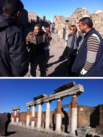
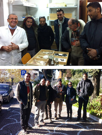
The visit to Pompeii (Figures 23–24) was organised in collaboration with one of the archaeologists working on the site, Dr A. Martellone, and the site was visited looking at both the archaeological issues and the new solutions for the conservation of monuments, pavements, mosaics and paintings. Part of the visit was dedicated to the Laboratory of Technological Research (Figure 24), where it was very interesting to look at the problems of conservation of organic materials, such as the remains of bread, of food in general, but also the remains of different kinds of colours which were used in antiquity for painting the walls of the splendid villas and domus of Pompeii. Particularly interesting was the visit to the exhibition of the casts of people escaping Pompeii during the volcanic eruption in AD 79.
Visit to Pompeii by the group of trainees from the DoA.

Visit to the laboratories of Pompeii and the group during the visit.

The visit to Pompeii was also a great occasion to talk about the concept of ‘maintenance’ of the site and about the importance of a management plan for a site so big but in some ways so similar to Cyrene in term of its vastness, issues and needs. We discovered how important it is to look at parallels to compare the problems and solutions, and to find the best way to reclaim a site. We certainly recommend for the next stage of the training to bring all of the groups to Pompeii and to find other similar cases to explain more practically the many concepts that in the past have been discussed during meetings and conferences, but which appear clearer and are more effective if touched upon directly in sites that are comparable in terms of the problems or solutions.
Another guided tour was organised by Prof. O. Menozzi to the site of Capestrano (Figure 25), which is quite famous in Abruzzo because of the discovery of the statue of the Warrior, which is now in the Museum of Chieti (Figure 26). Capestrano was important to understand the concept of valorisation of a multiperiod site, including remains from the seventh century BC to the Italic hill fort, the Roman village and the medieval castle, which is one of the best preserved of the area and is widely used for conferences, exhibitions and events. In this case, it was important for us to see how the archaeological park is not only related to the core of the site, which changes here from period to period, but how Capestrano represents an example of an extensive open-air museum that needs to be carefully monitored and maintained, not just the monuments, but also the environmental context, which is a natural park with sources, lakes, animals and rare plants. We could apply a similar approach to the wild and unique environmental contexts of the valleys around Shahat, safeguarding their archaeology and at the same time their natural uniqueness. This issue has been discussed in the past with the Association for Culture and Media in Shahat and it is certainly an interesting approach to comprehensively defining the maintenance and safeguarding of the sites.
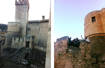
Visit to Capestrano: view of the medieval castle where there are also the storerooms and laboratories used for the restoration and study of the finds from the area.

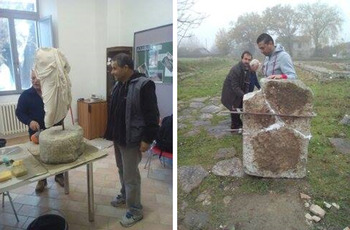
Fossombrone: the practical training.

Because of the visit at Capestrano we also visited the Museum of Chieti, where the statue of the Warrior is conserved, and Prof. V. d'Ercole and Prof. S. Agostini illustrated the statue and also the main issues caused by old restorations of the statue on the basis of the diagnostic analysis.
In general the concept of the diagnostic analysis has been illustrated widely, also looking at the different typologies of methodologies and technologies. We have seen the main tools and equipment for analysis and mapping of the damages on the stone, and we also used a digital microscope for direct mapping of the stone.
One important step in the training has been the composition, in collaboration with Prof. O. Menozzi and Dr M. G. Di Antonio, of specific forms in Arabic, Italian and English to catalogue an architectonic element, to map the damages and to plan the restoration. We think this is an important tool for Libyan restorers because it requires everybody to draft a project of restoration before starting it. We also included on the form a section for the documentation of restoration works, because it is also important to keep a record of the stages of restoration. It is vital for the future maintenance of the restored monument or element to know which processes and chemical materials have been used during the process of restoration.
One day was dedicated with Prof. V. d'Ercole and Dr M. G. Di Antonio to the problems of al-Jaghboub area. In this area, the necropolis in particular presents evidence of damage caused by looting. So we discussed together how to collaborate in the area in order to monitor the site, and also how to continue mapping together some new tombs which have been found by the DoA.
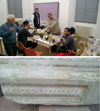
This theoretical part of the course was then complemented by practical work on building materials in limestone and marble from Fossombrone (Figures 27–28). For this part we were carefully tutored, step by step, by G. Buttarini, the restorer for the Italian Archaeological Mission in Cyrenaica and who has recently been working with the Urbino and Chieti missions. The trainees started manually cleaning a marble statue and an acanthus marble shelf brought from Fossombrone Museum's store, then the trainees went to the museum and learned the method of cleaning marble bases by spraying the product Biotin T, which is a wide-range biocide (which is based on ammonium salts) and must then be diluted (from 1 to 3% on the basis of the typology of the surface and nature of the biodeteriogen).
Fossombrone: the practical training in the lab.

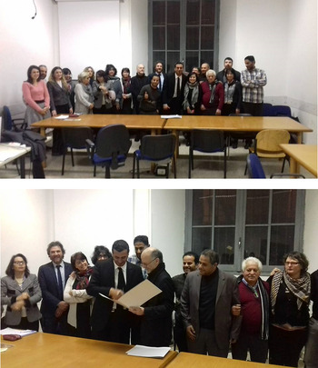
Rome: the meeting and the issuing of the diplomas.

During the residence in Urbino, the group of trainees visited the archaeological site of Fossombrone accompanied by Prof. O. Mei. Excavations were held at this site last summer and restoration work has been done on the wall paintings (frescoes) and the mosaic floors. They learnt about the architectural elements that have been restored. Restorers G. Buttarini and F. Budjenni, who had done restoration work in Libya during the 1970s, introduced the trainees in the laboratory to the materials (ammonium carbonate) and tools needed to conduct restorations.
Together with the practical work, the trainees continued with lectures, for instance by Dr F. Venturini on the history of mosaics’ use in the Mediterranean from Macedonian to late Roman times. Dr F. Venturini also guided the trainees in a field visit to the Arch of Augustus in Fano, the city's fortification towers, and the opening of Fano's new museum.
Maintenance and pre-restoration works were also performed at the archaeological site at Fossombrone, in a limited area, by first removing the vegetation and soil on the entrance's steps, then cleaning up the pieces of the marble with an iron brush before gluing them (with Acrylic 33) and adding a white finish paste.
At the end of the period, two days were organised in Rome to visit some of the archaeological areas there which presented issues relating to restoration and maintenance. The areas of the Foro Romano and of the Imperial Fora were visited thanks to a guided tour by Prof. S. Ensoli to the former and by an expert of the MIBACT to the latter. This tour was an important opportunity to look at very recent restorations and also to look at the new rehabilitation of the site.
The last day was dedicated to a meeting with all of the course organisers (Chieti, Roma 3 and Urbino Universities and the Italian Ministry of Cultural Heritage, Activities and Tourism) and with the participation of the Italian Ministry of Foreign Affairs (Figure 28) in order to discuss the goals and progress of the course, the main issues which have been illustrated, the following steps and the goals of the course.
All of the trainees received a certification for the course (Figure 28) and Abdulrahim Saleh Shariff received recognition for his work as Italian interpreter and translator from the four Italian institutions organising the course.
Recommendations
-
1. Continue cooperation with the Italian archaeological missions in Libya for training people in restoration.
-
2. Find a way to initiate an Italian-language study programme for Libyan inspectors.
-
3. Explore further the offer by the Italian Foreign Ministry and the Italian missions of graduate study opportunities in Italy for Libyan archaeological researchers.
-
4. Organise future stages of the course in Libya, allowing trainees the chance to continue restoration work in Libya to enhance the knowledge learned on this course.
Appendix II: Giarabub (El Djaghbub): the oasis and its problems (V. d'Ercole and M. G. Di Antonio)
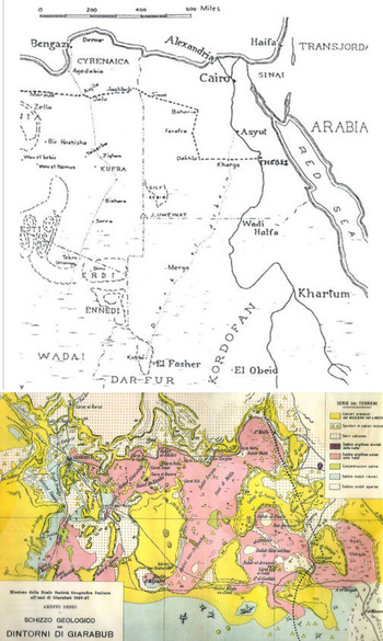
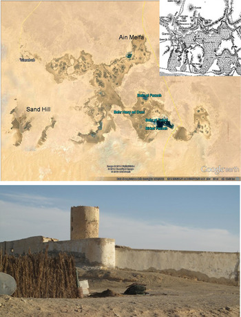
The oasis (Figures 29–30) of Giarabub (El Djaghbub) is situated in the eastern Libyan desert at the border with Egypt, which is about 40 km away. It consists of a large basin that falls somewhere up to 14 m below sea level. In fact the area is made up of four small oases (Kenrick Reference Kenrick2013, 329), namely Giarabub, Ain Melfa, Ain Abu Zaid and Fredgha (Figure 30), located in an area surrounded by an expanse of sandy and some rocky outcrops alternating with salt lakes and an area in which it is still possible to observe the earliest forms of fossilised marine life (Mohamed Reference Mohamed, Catani and Marengo1998). In ancient times these oases must have been in close contact with the oracle and the temple of Zeus Ammon in Siwa,Footnote 6 which became a place of worship for Libyans, Greeks and Egyptians. The area is not directly mentioned by Herodotus (IV, 181–83), although the oasis must have been of considerable importance. It based its economy on the salt trade by exploiting the resources of the salty lakes in the area; it was also particularly florid because of its richness in water sources that served as a reference point for water supply between Siwa and Augila along the east–west route through the desert that stretched from Egypt to the west coast of Africa. It can, however, be assumed that Giarabub fell within the sphere of interest of Siwa (Fakhry Reference Fakhry1944; Leahy Reference Leahy1990), and consequently the history of Siwa can be taken as a reference for bridging the lack of data about the Libyan oasis (Wright Reference Wright1997).
Giarabub-El Djaghbub: map with the location of the area (above) and geological map of the oasis (by A. Desio).

Giarabub-El Djaghbub: satellite view of the four oases (above) and a view of the castle.

The name of Giarabub emerges in only very recent history and its settlement is considered one of the most fascinating sites in eastern Cyrenaica (Marmarica). The first traveller who reached this place and gave news about it was the Englishman W. G. Browne, who went from Alexandria in March 1792 up to the eastern edge of the oasis. In February 1926, the oasis was occupied by Italian troops and was joined by a naturalistic mission sent by the Royal Italian Geographical Society (Desio et al. Reference Desio, Silvestri, Zuffardi Comerci, Cipolla, Chiarugi, Cugia, Florinda, Massari, Gestro, Vinci-Guerra and Lusina1928–31), who performed a thorough monographic study of the oasis. The area of the ancient settlement, a late Hellenistic and Roman site, was probably located in the area of the modern town, because numerous finds have been attested locally during building works since the beginning of last century.
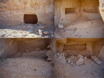
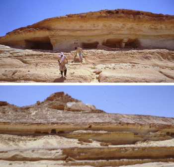
The territory of Giarabub is known archaeologically thanks to a survey carried out by Wright in 1955 that had led to the identification of a necropolis (Figures 31–32) in the village of Ain Melfa (Wright Reference Wright1997), about 20–25 km to the east of Giarabub, widely looted and used as a military base by the Australian contingent in 1941 during the war with Italy (Castagna Reference Castagna1950). The cemetery is located immediately to the north of Abyar Zerqun, at 112 m above sea level, about 10 km from the border with Egypt and today appears as a series of overlapping natural steps on whose southern walls there are hundreds of rock-cut chamber tombs (Figures 31–32), which are arranged in several parallel rows. A successful campaign of excavations was conducted in the necropolis in the ’90s by the DoA of Cyrene, which discovered six tombs whose type is very standardised with simple squared chamber tombs with narrow rectangular niches or loculi on the side walls and, at times, also on the back wall. The environs also appear to be of two types: the smaller rooms, of about 2 × 2 m, and those of larger dimensions, roughly double, about 4 × 4 m. Some of the tombs, such as Tomb A3, still preserves a short dromos clearly visible in the rock and the entrance with vaulted arch. Moreover, the presence of wooden remains (some fragments are preserved in the Museum of Cyrene) suggests that many gates were closed with sturdy wooden doors, sometimes coloured in red, whose remains can be often found within the tombs. The abundant presence of human bone remains, found both inside and outside of the burials, seems to suggest a plausible intensive exploitation of these tombs. Probably the dead bodies were housed both in the lateral niches cut into the rocky walls (as loculi realised by the long side) and inside the room, laid on funerary wooden beds which could have been placed over each other like modern bunk beds (Figures 31–32).Footnote 7
Giarabub-El Djaghbub: inner views of the funerary chambers.

Giarabub-El Djaghbub: the external appearance of the tombs.

This peculiarity of arrangement with parallel deposition coming from the exploitation of the wall, with rock-cut loculi opening on the long side, is common in the Hellenistic-Roman period in the eastern area (Astolfi and Di Carlo Reference Astolfi and Di Carlo2015).
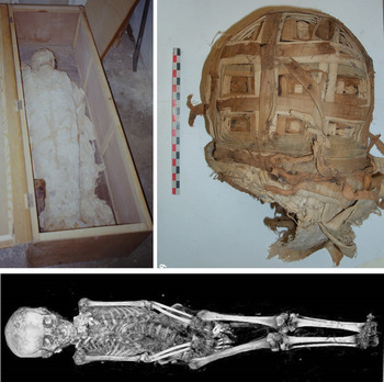
Another feature of the culture developed around this area is the mummification of the bodies of the dead, according to Egyptian ritual; the mummies were buried wrapped in a cloth held in place by strips of vegetable fibre, and special attention was paid to the skull bandage, wrapped with multi-layered bands that create a cross-shaped pattern, as can be seen in a specimen preserved in the Museum of Cyrene. The mummies found at this site are numerous and only a few of them have been brought to a safer place where they are currently preserved in the Museum of Cyrene and in the Department of Giarabub; many were in the graves that were robbed and savagely damaged (Figure 33).
The mummies from Giarabub-El Djaghbub.

The funerary equipment within the tombs is not rich but it is very well preserved and it is extremely important from an ethno-anthropological point of view.
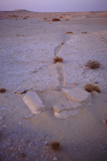
The emergency excavation (Mohamed Reference Mohamed, Gasperini and Marengo2007)Footnote 8 conducted in the necropolis of Ain Abu Zaid by the Libyan DoA led to the identification of several wells dug into the rock with canals (Figure 34) for water collection and a series of graves with very different features from Melfa, but very similar to the burials present at the Siwa oasis. It consists of rock-cut chamber tombs, quadrangular, which may contain four niches/loculi in the upper part of the side walls and sometimes even in the back one. Excavations have brought to light several mummies,Footnote 9 unfortunately many damaged, but the best preserved reveal a type of bandage with colourful fabric strips (white and brown) artfully intertwined to form three different sized squares in a kind of coffered ceiling effect;Footnote 10 the dead have their faces painted and hands placed inside the bandaging. Mostly these burials had been planned to accommodate groups of families; others only contain bodies, presumably female.
Giarabub-El Djaghbub: a rock-cut channel and a possible well.

In 2002 the DoA asked the MIBACT forFootnote 11 research and excavations in the area around the oasis of Giarabub (in the necropolis of Alfrydum, Aya, Abu Zaid, ByrBuSalamm, Aba Harth al Melfi) and after this request it was possible to do in 2003Footnote 12 a brief exploration of the area. During one of the inspections, on a plateau overlooking the necropolis was identified a large area, clearly an inhabited area confirmed by the finding of wooden fragments in quantity and hydraulic structures formed by cisterns dug directly into the bedrock.
Probably this area was the settlement related to the necropolis mentioned above, but unfortunately without conducting a second and longer survey, with archaeological excavations, it is not possible to determine with certainty the type of settlement, especially its phases of use.
The position in which the site is located certainly represents something important, as it is situated on the northern edge of the lake basin, in a high area overlooking and controlling the main road network between Giarabub and Siwa oasis.
About 10 km to the south of Giarabub was discovered a similar site, Sand Hill, with analogous hydraulic works, two cisterns, carved into the rock and linked together by a long channel which is cut into the bedrock. Not far away on a hill have been identified the remains of a tower used in the control and defence of the area; it is made of squared blocks that had to belong to a collapsed structure, and among them also a cistern and numerous fragments of wheel-made pottery. Moreover, in the east of Sand Hill, we find a series of rock-cut chamber tombs, fewer than those at Ain Melfa but of the same type. Some of these tombs still seem to be intact, but for both necropoleis, those graves that are still intact would probably have been arranged on the lower terrace, still covered by sand, earth and debris from the terraces above (d'Ercole and Martellone Reference d'Ercole, Martellone, Fabbricotti and Menozzi2006).
The presence of these two sites attesting both settlement and necropolis, within similar archaeological contexts, suggests that about two thousand years ago, around the depression of Giarabub, there was a settlement system produced by a very peculiar ecosystem. Indeed the spring waters, in which the oasis was rich, facilitated the inhabitants’ livelihoods, some crop production and possibly livestock farming. An important and fundamental resource was the mineral salt, which is found abundantly around the salty lakes, not least because, as mentioned above, its location is found along the way of the oases connecting the Nile Valley to the Atlantic coast, passing through Giarabub and the oases of Augila, al-Jufrah and Ghadames in Libya to arrive at what are now Algeria and Morocco.
It was an important caravan route located on the northern edge of the great Sahara Desert and some of these oases like Ghadames and Giarabub were used as a passage on the crossroads with the caravan routes towards the south and then towards the centre of the African continent. From Giarabub, it is possible to arrive at the oasis of Kufra and then Sudan and Chad, while from Ghadames there is a way to Ghaat and Nigeria, up to the Gulf of Guinea.
However, these sites have not been exhaustively surveyed and excavated. Looking at the geomorphology of the area and at the distribution of natural resources, it is possible that there were two other settlements, one to the south-east and the other one just below the present village of Giarabub. If so, these settlements could create a quadrilateral organisation of sites around the oasis for a closer control of the resources, but also of the road going to Tobruk and to the sea (site 4: Giarabub), the eastern route to Siwa and Egypt (site 1: Ain Melfa), the route south to Kufra and central Africa (site 3), and finally the western slope in the direction of Jalo and the western coasts (site 2: Sand Hill).
In 2009 the University Museum of Biomedical Sciences of ChietiFootnote 13 made a preliminary anthropometric and palaeopathological study of the mummies and of the skeletal remains from Giarabub. At the first analysis, identified were four complete mummies and one head, which had received an artificial treatment, but at the moment the embalming techniques are unknown. They are all in quite poor condition, mostly due to causes of deterioration, which can be attributed to aggressive biological agents (mould and fungi), insects and rodents as well as unsuitable environmental factors.
In 2013 and 2014 Mazin A. S. Abdalgader el Mziene, together with the DoA of Giarabub, and in collaboration with the mission of the MIBACT at Giarabub, organised a series of surveys in order to identify the main problems and issues of the sites of this context. They have found that some of the graves have been heavily looted and damaged, and even partially destroyed. It is probable that a large number of tombaroli (grave robbers) have repeatedly looted and robbed the most visible graves, especially to export material across the Egyptian border and sell the stolen objects mostly via the internet or through the black market. At the moment, unfortunately, it is difficult to determine the extent of the damage; the only way is to continue to document what is visible. For this reason especially we are collaborating with Libyan colleagues in order to organise more surveys of these sites, while together with other Italian missions (such as the Libyan missions of Chieti, Urbino and Roma 3 Universities) we are monitoring the area using the remote sensing protocol already tested by Chieti University mission.
Obviously in a quieter period, it will be necessary to carry out more systematic field surveys, as well as excavations and conservation projects for this area, in order to contextualise more properly the limited information about one of the most unknown contexts of the Libyan desert. Already at the preliminary assessment, these sites seem to attest a well-organised system with settlements and necropolis quite close to the road network, controlling the area and its resources.
The sites’ locations have proved to be unlucky. At oases along the caravan routes (Giddy Reference Giddy1987), which were the fortune of the sites in antiquity but are now determining their destruction – because most of the looters come from the Egyptian border to rob tombs and sites, returning to Egypt within hours – the sites are probably where the long road begins for the trade in stolen goods.