NORTH OF THE ANTONINE WALL
HIGHLAND
(1) Belladrum (NH 517 421): further excavationFootnote 25 of the denarius hoard findspot showed that it had been buried in an area marked by ancient monuments, with early prehistoric cairns and stone rows succeeded by Bronze Age/early Iron Age settlement and field-systems.
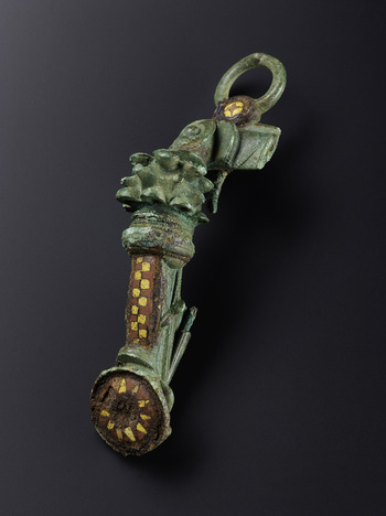
(2) Auldearn (NH 90 55): a remarkably large Romano-British brooch, 144 mm long, was found by metal-detecting (fig. 3).Footnote 26 It is a hybrid of trumpet and headstud types with complex enamelled and cast-in decoration. An Iron Age ring-terminal torc found some distance away may well be plough-disturbed from the same hoard. Nothing is currently known around the findspot.Footnote 27
The massive hybrid Romano-British brooch from Auldearn. L 144 mm. (Photo: Neil McLean, © National Museums Scotland)

PERTH AND KINROSS
(1) Longforgan, The Snabs (NO 2980 2995): two sections of the camp ditchFootnote 28 were recorded near the south-west corner, c. 1.7 m wide and 0.8–0.9 m deep. One section had an ‘ankle-breaker’ slot which was lacking in the other, only 2 m away. Limited excavation in the interior produced no certainly Roman features.
(2) Dunning: (a) Kincladie Wood (NO 0235 1521):Footnote 29 a trench across the camp defencesFootnote 30 immediately west of the north-west gate revealed that the V-shaped ditch (3.1 m wide, 1.5 m deep) had been recut on the same line after some 0.7 m of silty sand had accumulated.Footnote 31 Both ditches had ‘ankle-breaker’ slots. A substantial slot to the rear of the slumped earth rampart may have been for a timber revetment. A second trench exposed a waterlogged V-shaped ditch in front of the titulus, with a probable recut in an attempt to aid drainage (potentially quite recently). (b) Pitcairns House (NO 0258 1451–0283 1455): trial-trenchingFootnote 32 established the line of the camp's southern ditch towards its eastern end. It lay at a slight angle to the known southern line, reflecting a change beyond an entrance where the medieval and modern road ran. The steep V-profile ditch (2.1–2.5 m wide, 1.6 m deep) had an ‘ankle-breaker’ slot; a recut after silting confirms the reuse of the entire circuit in a second phase.Footnote 33 In places stones or gravel were placed in the ‘ankle breaker’ to aid drainage. Rampart traces suggest it was c. 3 m wide with a 2 m berm.
FALKIRK
(1) Camelon, Redbrae Road (NS 866 806): excavationsFootnote 34 south-east of the fort complex revealed a broadly rectilinear series of ditches (some recut) probably connected to a field-system,Footnote 35 and a series of pits in one area. One ditch was clay-lined, suggesting a role in water management.
THE ANTONINE WALL
EAST DUNBARTONSHIRE
(1) Bearsden, 25 Glenburn Road (NS 5392 7211): evaluationFootnote 36 over the projected line of the Wall c. 500 m west of the fort found no trace of the rampart.
FALKIRK
(1) Falkirk: (a) Frobisher Avenue (NS 8755 7998): excavationsFootnote 37 on the berm of the Wall showed that all Roman levels had been destroyed. (b) Pleasance Gardens (NS 8856 7977): excavationsFootnote 38 west of the fort, between Clyde Cottage and Erskine Church, showed that modern disturbance had destroyed the Wall in this area. However, two trenches in the garden of Clyde Cottage located a clay-cheeked rampart and part of a substantial ditch, with a thin metalled road surface heading west. This is likely to represent a western annexe for the fort.Footnote 39 Rubbish had been dumped in the ditch when the fort was abandoned.
SOUTH OF THE ANTONINE WALL
NORTH AYRSHIRE
(1) Poteath Burn (NS 1963 5231): two substantial sherds of second-century ring-necked flagons recovered in the 1960s from silt at the mouth of the burn were recently reported.Footnote 40 It raises the possibility of a Roman installation in the area as part of the Clyde coast system.
SCOTTISH BORDERS
(1) Hassendean Bank (NT 55 19): an Eggers type 160 dipper was found by metal-detecting close to two later prehistoric cropmark enclosures.Footnote 41
SOUTH LANARKSHIRE
(1) Howecleuch: (a) (NT 0251 1399–0283 1408): cobbling and possible kerb-stones were recordedFootnote 42 in four damaged areas of the Roman road from Crawford to Beattock fortlet. The construction was simple, with a single layer of metalling set into compact sediment. (b) Fopperbeck Ford (NT 0105 1448): test-pittingFootnote 43 under the modern forestry road, which lies on the Roman line, revealed an earlier course of metalling.
DUMFRIES AND GALLOWAY
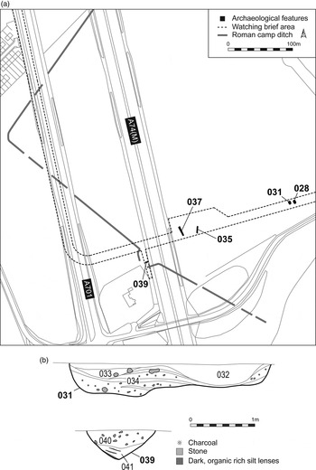
(1) Beattock, Bankend (NT 0830 0187–0871 0195): a watching-briefFootnote 44 on a cable trench across the southern corner of the campFootnote 45 recorded the oblique traverse of the south-western Stracathro gatewayFootnote 46 and two field ovens (around NT 0861 0193; fig. 4), with interleaved ash layers at one end indicating multiple uses.Footnote 47 Two V-sectioned ditches and a series of other features in the interior had no associated dating evidence. No trace of the south-east side was noted, confirming this has been lost to river erosion.
The temporary camp at Bankend, Beattock. (a) Extent of recent work with key features marked. Features 028 and 031 are ovens; 035 and 037 are ditches inside the camp; 039 is the traverse of the Stracathro gate, correcting the rectified aerial photo position. (b) Upper: section of field oven 031. Lower: section of traverse 039. (Drawings by courtesy of CFA Archaeology)

(2) Auldgirth (NX 91 88): a lead mount with the head of a Maenad was found by metal-detecting close to the Roman road up the Nith valley.Footnote 48