1. Introduction
The Triassic–Jurassic ophiolites scattered throughout the Hellenic–Dinaric orogen testify to events of obduction and subduction. However, since the early studies, the interpretation of these ophiolites has been characterized by the contrast between researchers who see the existence of a single ocean basin interposed between Africa–Adria and Eurasia and others who propose the existence of multiple oceans separated by microcontinents.
In the last decades, increasingly detailed data on the geochemistry of the ophiolites, their age and metamorphism, including the continental units involved in the orogenic process, has strengthened the first-order geological constraints allowing more reliable geodynamic reconstructions. The reconstruction of the deformation history often focuses in areas where large ophiolitic masses are in contact with the continental units, or in the inner sectors of the chain characterized by orogenic-related metamorphism.
Convergence between Africa and Eurasia – that led to intraoceanic subduction in Early–Middle Jurassic times – is still active. This has resulted in a complex structure of the chain, where the stages of compressive strain, linked to subduction–obduction and continental collision processes, are added to those related to the Aegean extension.
The study of a large sector of the chain located between the front of the ophiolitic units and the external sectors of the continental margin of Adria was used to shed light on the evolutionary history of the Hellenides.
In particular, we studied, from structural, stratigraphic and biostratigraphic points of view, the units located in Boeotia, a key area between the Pelagonian and the Parnassus units (considered alternatively as microcontinents or part of Adria). The fact that such a broad disagreement exists in the palaeogeographic interpretation of these geotectonic zones exposed in Boeotia reflects the great complexity of the area and its importance in interpreting the geodynamic evolution of the entire chain.
2. Overview of the geology and geodynamics of the Hellenic Chain
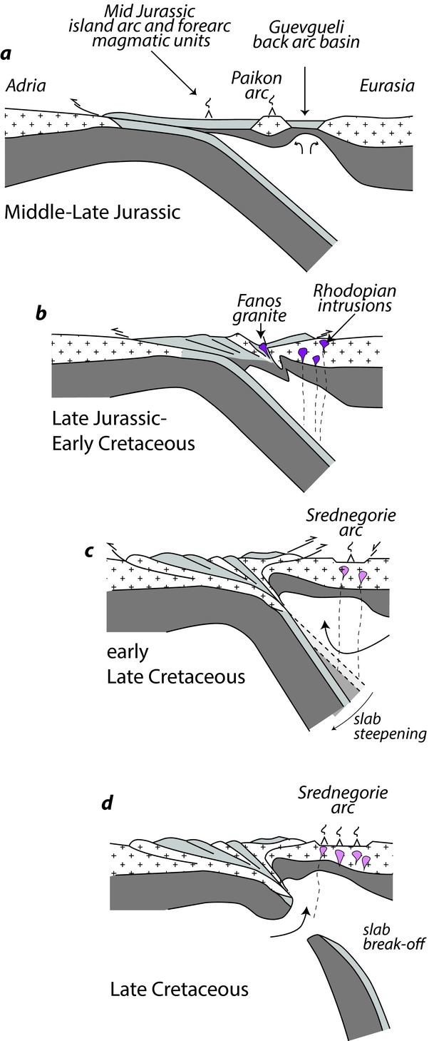
The Hellenic orogen evolved through (i) a Permo-Triassic intracontinental rifting stage related to Pangaea break-up (Ferrière, Reference Ferrière1982; Capedri et al. Reference Capedri, Toscani, Grandi, Venturelli, Papanikolaou and Skarpelis1997; Pe-Piper, Reference Pe-Piper1998; Bortolotti & Principi, Reference Bortolotti and Principi2005; Robertson, Reference Robertson2012 and many others); (ii) oceanic spreading from Middle Triassic time with mid-ocean ridge (MOR) lithosphere production (Bortolotti et al. Reference Bortolotti, Marroni, Pandolfi and Principi2005, Reference Bortolotti, Chiari, Marroni, Pandolfi, Principi and Saccani2013; Dilek, Shallo & Furnes, Reference Dilek, Shallo and Furnes2005 and many others); (iii) intraoceanic subduction in Early–Middle Jurassic times along with island arc and back-arc basin formation (Mercier, Reference Mercier1968; Bébien, Platvoet & Mercier, Reference Bébien, Platvoet and Mercier1994; Shallo, Reference Shallo1994; Beccaluva et al. Reference Beccaluva, Coltorti, Prempti, Saccani, Siena and Zeda1994; Bortolotti et al. Reference Bortolotti, Kodra, Marroni, Mustafa, Pandolfi, Principi and Saccani1996; Robertson & Shallo, Reference Robertson and Shallo2000; Rassios & Smith, Reference Rassios, Smith, Dilek, Moores, Elthon and Nicolas2000 and many others); (iv) intraoceanic thrusting associated with high temperature – low pressure (HT–LP) metamorphism since Middle Jurassic time (Spray & Roddick, Reference Spray and Roddick1980; Dimo-Lahitte, Monié & Vergély, Reference Dimo-Lahitte, Monié and Vergély2001) followed by obduction since Late Jurassic time (Ferrière, Reference Ferrière1975; Baumgartner, Reference Baumgartner1985; Çollaku et al. Reference Çollaku, Cadet, Bonneau and Jolivet1992; A. De Bono, unpub. Ph.D. thesis, Univ. Lausanne, 1998 among many others); (v) continental collision in Cretaceous time and ongoing shortening until middle Eocene time; and finally (vi) late orogenic extension of the nappe stack, starting in late Eocene time (Lips, White & Wijbrans, Reference Lips, White and Wijbrans2000; Jolivet et al. Reference Jolivet, Faccenna, Goffé, Burov and Agard2003 and many others). In mainland Greece the orogenic wedge is represented by thrust sheets stacked with a NNW trend and generally with a top-to-the-W vergence (Figs 1–3).
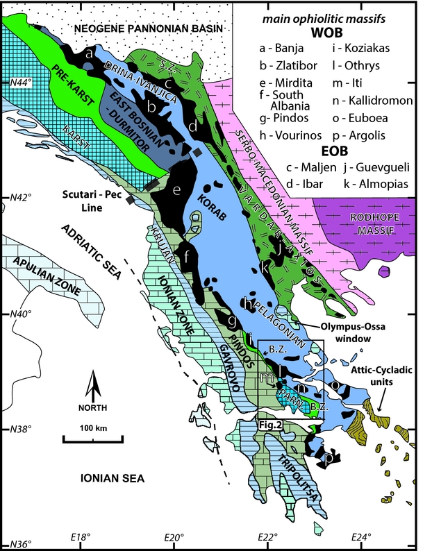
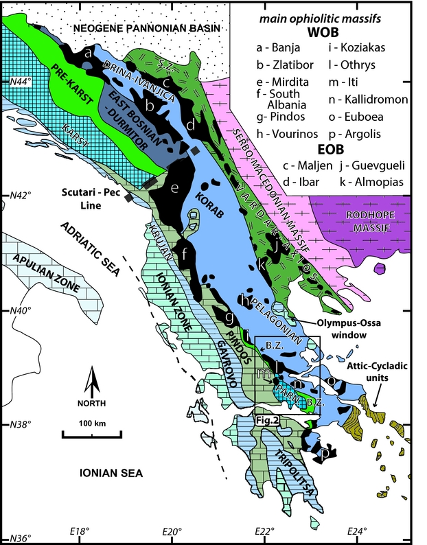
Tectonic sketch map of the Dinaric–Hellenic Orogenic Belt showing the main geotectonic zones and distribution of ophiolitic massifs (in solid black). WOB – western ophiolite belt; EOB – eastern ophiolite belt; B.Z. – Boeotian Zone; S.Z. – Sava Zone; PARN. – Parnassus Zone (modified after Bortolotti et al. Reference Bortolotti, Chiari, Marroni, Pandolfi, Principi and Saccani2013).
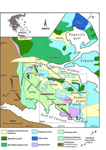
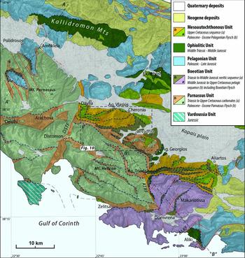
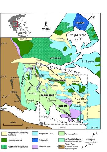
Simplified geological map of Central Greece, with main tectonic units. Location of the studied area is indicated. Modified after Celet, Ferrière & Wigniolle (Reference Celet, Ferrière and Wigniolle1977), Ferrière (Reference Ferrière1982) and geological maps of the IGME (Greek Institute of Geology and Mineral Exploration).
Schematic geological cross-section showing relationships between the main tectonic units in Central Greece (see Fig. 2 for location and legend). J-K1 – Late Jurassic – Early Cretaceous deformations; T – Tertiary deformations.

Aubouin (Reference Aubouin1959, Reference Aubouin1965), applying the geosyncline theory, proposed the first comprehensive description of the geological evolution of the Hellenic belt: the orogen was divided according to the Mesozoic stratigraphy of the involved terrains into ‘isopic zones’; then the orogenic process allowed the differentiation of the External Hellenides, as the zones affected by deformation during Tertiary time and occupying the western part of the chain, and the Internal Hellenides to the east, which recorded older orogenic deformations since Middle Jurassic time (Brunn, Reference Brunn1960).
Nowadays the nomenclature of Aubouin and co-workers is still used even if the term ‘isopic zone’ has been transfigured into ‘geotectonic zones’, partly corresponding to the ‘terranes’ concept.
Basement and supracrustal rocks cropping out in the Internal Hellenides are grouped mainly within the Pelagonian geotectonic zone (or Pelagonia) whereas the External Hellenides are mostly represented by supracrustal thrust sheets consisting, from east to west, of the Boeotian Zone, Parnassus Zone, Pindos Zone, Gavrovo–Tripolitsa Zone and Ionian Zone (Figs 1, 2).
The Pindos and Ionian zones are characterized by pelagic sedimentation beginning in Late Triassic and late Early Jurassic times, respectively. Moreover, the Pindos deep-sea sedimentation is alternatively interpreted as pertaining to a thinned continental crust characterized by mafic intrusion of Middle–Late Triassic age (Fleury, Reference Fleury1980), as an oceanic domain (Aubouin, Reference Aubouin1959; Thiébault, Reference Thiébault1982; Robertson et al. Reference Robertson, Clift, Degnan and Jones1991) or a combination of thinned continental crust passing through a transitional zone in the oceanic domain (Degnan & Robertson, Reference Degnan and Robertson1998, Reference Degnan, Robertson, Robertson and Mountrakis2006).
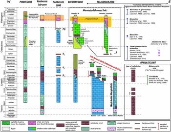
The Pelagonian, Boeotian, Parnassus and Gavrovo–Tripolitsa zones share a similar Triassic–Middle Jurassic stratigraphy represented by shallow-water carbonates. The shallow-water sedimentation on the Pelagonian and Boeotian platforms ceased in Late Jurassic time as a direct consequence of the obduction processes (Baumgartner, Reference Baumgartner1985; Celet, Clément & Ferrière, Reference Celet, Clément and Ferrière1988; A. De Bono, unpub. Ph.D. thesis, Univ. Lausanne, 1998) whereas general shallow-water conditions persisted in the Parnassus and Gavrovo–Tripolitsa zones throughout Mesozoic and Eocene times, respectively (Fig. 4).
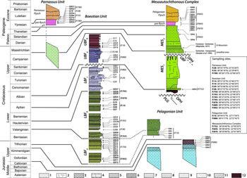
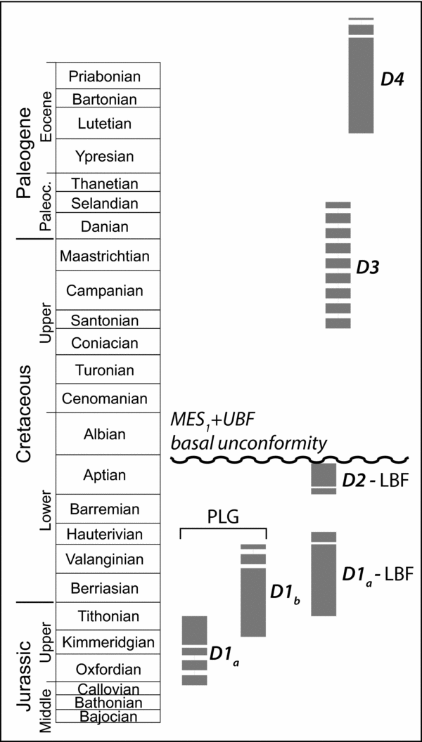
Synoptic table representing schematic lithostratigraphic columns of various units pertaining to the different geotectonic zones and tectono-metamorphic events in the ophiolite nappe and Pelagonian Unit. New data presented in this work integrate the following literature: Pindos zone: C. Beck, unpub. Ph.D. thesis, Univ. Science and Technology, Lille (1975); Fleury (Reference Fleury1980); Ananiadis et al. (Reference Ananiadis, Vakalas, Zelilidis and Stoykova2004); Neumann & Zacher (Reference Neumann and Zacher2004). Vardoussia Sub-zone: R. Ardaens, unpub. Ph.D. thesis, Univ. Lille (1978); Celet (Reference Celet1979). Parnassus Zone: Celet (Reference Celet1962); Richter et al. (Reference Richter, Müller, Hottinger and Risch1995); Carras & Tselepidis (Reference Carras, Tselepidis, Solakius and Kati2001). Boeotian Zone: B. Clément, unpub. Ph.D. thesis, Univ. Lille (1983); Steuber (Reference Steuber1993); Steuber et al. (Reference Steuber, Gotzes, Raeder and Walter1993); Danelian & Robertson (Reference Danelian and Robertson1998); Nirta et al. (Reference Nirta, Moratti, Piccardi, Montanari, Catanzariti, Carras and Papini2015). West Maliac Margin Units: Ferrière (Reference Ferrière1982); Baumgartner (Reference Baumgartner1985); Baumgartner et al. (Reference Baumgartner, Danelian, Dumitrica, Goričan, Jud, Dogherty, Carter, Conti, De Wever, Kito, Marcucci, Matsuoka, Murchey and Urquart1993); Ferrière et al. (Reference Ferrière, Baumgartner and Chanier2016). Mesoautochthonous Unit: Wigniolle (Reference Wigniolle1977); B. Clément, unpub. Ph.D. thesis, Univ. Lille (1983); Steuber et al. (Reference Steuber, Gotzes, Raeder and Walter1993); Steuber, Raeder & Walter (Reference Steuber, Raeder and Walter1994); Richter, Müller & Mihm (Reference Richter, Müller and Mihm1996); Richter, Müller & Risch (Reference Richter, Müller and Risch1996); Fazzuoli & Carras (Reference Fazzuoli and Carras2007); Photiades et al. (Reference Photiades, Carras, Bortolotti, Fazzuoli and Principi2007). Pelagonian Zone: Baumgartner & Bernoulli (Reference Baumgartner and Bernoulli1976); Celet & Ferrière (Reference Celet and Ferrière1978); B. Clément, unpub. Ph.D. thesis, Univ. Lille (1983); Baumgartner (Reference Baumgartner1985); Baumgartner et al. (Reference Baumgartner, Danelian, Dumitrica, Goričan, Jud, Dogherty, Carter, Conti, De Wever, Kito, Marcucci, Matsuoka, Murchey and Urquart1993, Reference Baumgartner, Bartolini, Carter, Conti, Cortese, Danelian, De Wever, Dumitrica, Dumitrica-Jud, Goričan, Guex, Hull, Kito, Marcucci, Matsuoka, Murchey, O'Dogherty, Savary, Vishnevskaya, Widz, Yao, Baumgartner, O'Dogherty, Goričan, Urquhart, Pillevuit and Wever1995a ); Danelian (Reference Danelian1994); Richter, Müller & Risch (Reference Richter, Müller and Risch1996); A. De Bono, unpub. Ph.D. thesis, Univ. Lausanne (1998). Ophiolitic Unit: Baumgartner (Reference Baumgartner1984, Reference Baumgartner1985, Reference Baumgartner, Baumgartner, O'Dogherty, Goričan, Urquhart, Pillevuit and Wever1995); Jones, De Wever & Robertson (Reference Jones, De Wever and Robertson1992); De Wever (Reference De Wever, Baumgartner, O'Dogherty, Goričan, Urquhart, Pillevuit and Wever1995); Danelian, Robertson & Dimitriadis (Reference Danelian, Robertson and Dimitriadis1996); Danelian & Robertson (Reference Danelian and Robertson2001); Chiari et al. (Reference Chiari, Bortolotti, Marcucci, Photiades and Principi2003, Reference Chiari, Bortolotti, Marcucci, Photiades, Principi and Saccani2012, Reference Chiari, Baumgartner, Bernoulli, Bortolotti, Marcucci, Photiades and Principi2013); Bortolotti et al. (Reference Bortolotti, Carras, Chiari, Fazzuoli, Marcucci, Photiades and Principi2003, Reference Bortolotti, Chiari, Marcucci, Photiades, Principi and Saccani2008, Reference Bortolotti, Carras, Chiari, Fazzuoli, Marcucci, Nirta, Principi and Saccani2009); Nirta et al. (Reference Nirta, Bortolotti, Chiari, Menna, Saccani, Principi and Vannucchi2010); Kukoč et al. (Reference Kukoč, Goričan, Kosir, Belak, Halamic and Hrvatović2012); Ozsvart et al. (Reference Ozsvart, Dosztaly, Migiros, Tselepidis and Kovacs2012).

This differentiation in the stratigraphy of the External Hellenides and Pelagonia is attributed to the control exerted by tectonic structures inherited from the Permo-Triassic rifting stage, or by the influence of the compressional tectonic regime starting from Middle–Late Jurassic times, or as a combination of both.
The Pelagonian Zone consists of Palaeozoic continental basement and its mostly carbonate Mesozoic cover that are bounded to the east by the ophiolite-bearing units of the Vardar–Axios Zone (East Vardar ophiolites of Schmid et al. Reference Schmid, Bernoulli, Fügenschuh, Matenco, Schefer, Schuster, Tischler and Ustaszewski2008, here referred to as the Eastern Ophiolite Belt, EOB) and to the west by several ophiolitic massifs, including the Vourinos, Pindos, Koziakas, Othrys, Iti, Kallidromon and Argolis ophiolite complexes, arranged along an external ophiolite belt (West Vardar ophiolites of Schmid et al. Reference Schmid, Bernoulli, Fügenschuh, Matenco, Schefer, Schuster, Tischler and Ustaszewski2008, here referred to as the Western Ophiolite Belt, WOB). Both ophiolite belts can be traced northwards into the Balkans: the WOB continues into the Mirdita Zone of Albania, curves along the Scutari–Pec line and then continues in the Dinaride Ophiolite Belt whereas the EOB continues straight into the Sava Zone up to the Pannonian Basin (Fig. 1).
The ophiolites of the EOB thrust onto the eastern margin of the Pelagonian Zone whereas the WOB units are emplaced both on the western margin of Pelagonia and over the Pindos Zone (namely over the Tertiary Pindos Flysch) of the External Hellenides. Whereas a general consensus exists about the location of the root zone of the EOB in the Vardar–Axios Zone (or Sava Zone, Schmid et al. Reference Schmid, Bernoulli, Fügenschuh, Matenco, Schefer, Schuster, Tischler and Ustaszewski2008), the origin of the WOB represents a long-lasting point of dispute among authors. Depending on where the root zones of the two ophiolitic belts are located, two main palaeogeographic interpretations were proposed for the Pelagonian Zone. In the hypothesis that both the EOB and WOB shared a unique root zone in the Vardar–Axios Zone (Bernoulli & Laubscher, Reference Bernoulli and Laubscher1972; Dercourt, Reference Dercourt1972; Zimmerman, Reference Zimmerman, Shagam, Hargraves, Morgan, Houten, Burk, Holland and Hollister1972; Zimmerman & Ross, Reference Zimmerman and Ross1976; Jacobshagen et al. Reference Jacobshagen, Durr, Kockel, Kopp, Kowalczyk, Berckhamer, Buttner, Closs, Roeder and Schmidt1978; Ferrière, Reference Ferrière1982; Bortolotti et al. Reference Bortolotti, Kodra, Marroni, Mustafa, Pandolfi, Principi and Saccani1996, Reference Bortolotti, Marroni, Pandolfi and Principi2005, Reference Bortolotti, Chiari, Marroni, Pandolfi, Principi and Saccani2013; Schmid et al. Reference Schmid, Bernoulli, Fügenschuh, Matenco, Schefer, Schuster, Tischler and Ustaszewski2008; Kilias et al. Reference Kilias, Frisch, Avgerinas, Dunkl, Falalakis and Gawlick2010), a unique ocean basin is postulated (Maliac–Vardar Ocean) while Pelagonia represents the easternmost rim of the Adria continental margin facing the oceanic domain to the east. On the other hand, the assumption of the root zone of the WOB in a different location, classically located in the Pindos Zone (Hynes et al. Reference Hynes, Nisbet, Smith, Welland and Rex1972; Mercier, Vergély & Bébien, Reference Mercier, Vergély and Bébien1975; Nance, Reference Nance1981; Jones & Robertson, Reference Jones and Robertson1991; Shallo, Kodra & Gjata, Reference Shallo, Kodra, Gjata, Malpas, Moores, Panayiotou and Xenophontos1992; Smith, Reference Smith, Prichard, Alabaster, Harris and Neary1993; Beccaluva et al. Reference Beccaluva, Coltorti, Prempti, Saccani, Siena and Zeda1994; Robertson et al. Reference Robertson, Dixon, Brown, Collins, Morris, Pickett, Sharp, Ustaömer, Morris and Tarling1996; Clift & Dixon, Reference Clift and Dixon1998; Rassios & Dilek, Reference Rassios and Dilek2009; Ghikas, Dilek & Rassios, Reference Ghikas, Dilek and Rassios2010; Robertson, Reference Robertson2012), necessarily implies the presence of a microcontinent, namely Pelagonia. According to more complex reconstructions, especially around the Parnassus Zone, the main Pindos ‘Ocean’ would be structured into several oceanic branches isolating continental slivers or microplates (Robertson & Degnan, Reference Robertson and Degnan1993; Skourlis & Doutsos, Reference Skourlis and Doutsos2003; Papanikolaou, Reference Papanikolaou2009; Kaplanis et al. Reference Kaplanis, Koukouvelas, Xypolias and Kokkalas2013).
This study investigates from the lithostratigraphic, biostratigraphic and structural points of view the complex tectonic stack exposed in Boeotia in Central Greece (Fig. 2). This area is located at the boundary between the Internal Hellenides (Pelagonian thrust sheets) and the External Hellenides (Boeotian Unit and Parnassus Unit). Ophiolite-bearing units top the tectonic pile, resulting from Mesozoic obduction and collisional events. The tectonic stack is further complicated by the Cenozoic compressional and extensional phases.
Addressing the main debated aspects concerning the origin of the WOB, the ages of deformation and their effects on the stratigraphic evolution of the involved rocks, we aim to propose a reconstruction of the Hellenic orogen with a particular emphasis on the period between obduction and continental collision. This intent was pursued by comparing the obtained data with consolidated data concerning the main metamorphic events recorded in the more Internal Hellenides, the geochemistry and age of the ophiolites and the main stratigraphic constraints obtained in other sectors of the belt.
3. Geology and lithostratigraphy of the Boeotian tectonic units
The study area belongs to the Boeotia region in Central Greece. It is located between the North Euboea–Sperchios graben to the north, the Corinth Gulf to the south, the Parnassus massif to the west and the Kopais plain to the east (Fig. 2).
The tectonic stack includes at its top the oceanic units that crop out as a large thrust nappe in the Kallidromon and Iti massifs or as small tectonic slices between the Pelagonian Unit, on top, and the Boeotian or Parnassus units, below (Fig. 3). The Ophiolite Unit is almost totally represented by an ophiolitic mélange embedding mostly ultramafic rocks in a shaly-sandy matrix. These ophiolites, along with the nearby Othrys ophiolites, are attributed to the WOB (Fig. 1). In this work we favour a working hypothesis in which ophiolites of both the EOB and WOB originated from a unique oceanic basin (i.e. the Maliac–Vardar Ocean, see Ferrière, Chanier & Ditbanjong, Reference Ferrière, Chanier and Ditbanjong2012 and Bortolotti et al. Reference Bortolotti, Chiari, Marroni, Pandolfi, Principi and Saccani2013 for discussion).
From Late Jurassic times onwards the ocean-derived units overthrust the carbonate sequences of the Pelagonian Unit, here regarded as the inner deformed rim of the Adria continental margin, and during Early–Late Cretaceous times both the ocean-derived and Pelagonian units overthrust the Boeotian Unit. Aptian to Upper Cretaceous deposits unconformably cover this tectonic stack, which in turn is superimposed westwards above the Parnassus carbonate platform. This tectonic pile was further cut by out-of-sequence thrusts and extensional events of Tertiary age that further complicated the Late Cretaceous superposition geometry (Fig. 3).
In Boeotia, the Pelagonian, Boeotian and Parnassus units represent the continental-derived units. The exposed portions of these units evidence a similar stratigraphy for the Late Triassic – Middle Jurassic age range, characterized by shallow-water carbonate. Crystalline Variscan basement followed by a syn-rift sequence of Late Permian – Early Triassic age (De Bono et al. Reference De Bono, Martini, Zaninetti, Hirsch, Stampfli and Vavassis2001) underlie the Pelagonian Platform, whereas the basement of the Boeotian and Parnassus carbonates is not exposed. Since Middle–Late Jurassic times transition pelagic sedimentation took place in the Boeotian Zone (Celet, Clément & Ferrière, Reference Celet, Clément and Ferrière1976, Reference Celet, Clément and Ferrière1988; Danelian & Robertson, Reference Danelian and Robertson1998). In the same period the Parnassus Zone and external Pelagonian Zone experienced an emersion episode marked by bauxite deposits (b1 horizon, Papastamatiou, Reference Papastamatiou1960; Papastamatiou et al. Reference Papastamatiou, Tataris, Katsikatsos and Maragoudaxis1962a ,b). Following gradual Late Jurassic westward obduction, the sedimentation in the Pelagonian Platform ended after a phase of pelagic sedimentation (Celet, Ferrière & Wigniolle, Reference Celet, Ferrière and Wigniolle1977; Ferrière, Reference Ferrière1982; Baumgartner, Reference Baumgartner1985) while the Parnassus Zone experienced neritic sedimentation punctuated by subaerial exposure events until Late Cretaceous time (Papastamatiou, Reference Papastamatiou1960; Celet, Reference Celet1962, Reference Celet1979; Carras & Tselepidis, Reference Carras, Tselepidis, Solakius and Kati2001).
Some authors have interpreted the Pelagonian Platform as a microcontinent drifted away from the Adria margin during Early Triassic times and separated by the Pindos ‘Ocean’ (Robertson et al. Reference Robertson, Clift, Degnan and Jones1991; Smith, Reference Smith, Prichard, Alabaster, Harris and Neary1993; Jones & Robertson, Reference Jones and Robertson1994; Degnan & Robertson, Reference Degnan and Robertson1998; Robertson & Shallo, Reference Robertson and Shallo2000; Stampfli & Borel, Reference Stampfli, Borel, Cavazza, Roure, Spakman, Stampfli and Ziegler2004). Similarly, the Parnassus Platform was also regarded as a continental block detached from Adria and separated by a secondary oceanic strand (Kerassia-Milia Ocean; Robertson & Degnan, Reference Robertson and Degnan1993; Pe-Piper & Piper, Reference Pe-Piper and Piper2002). Conversely, in the working hypothesis adopted here, we consider the Pelagonian, Boeotian and Parnassus units as units detached from the Adria continental margin and successively overthrust westwards during the Mesozoic to Tertiary compressional phases (Bernoulli & Laubscher, Reference Bernoulli and Laubscher1972; Ferrière, Reference Ferrière1982, Reference Ferrière1985; Baumgartner, Reference Baumgartner1985; Bortolotti et al. Reference Bortolotti, Chiari, Marcucci, Marroni, Pandolfi, Principi and Saccani2004b , Reference Bortolotti, Chiari, Marroni, Pandolfi, Principi and Saccani2013; Schmid et al. Reference Schmid, Bernoulli, Fügenschuh, Matenco, Schefer, Schuster, Tischler and Ustaszewski2008; Ferrière, Chanier & Ditbanjong, Reference Ferrière, Chanier and Ditbanjong2012).
The stratigraphy of the various units described below and the main tectono-metamorphic events are summarized in Figure 4.
3.a. Adria-derived units
3.a.1. Pelagonian Unit
Palaeozoic crystalline basement of the Pelagonian Unit is sporadically exposed in Boeotia and Euboea Island; it is locally intruded by granites (A. De Bono, unpub. Ph.D. thesis, Univ. Lausanne, 1998) and represents the lowermost part of the Pelagonian Unit in the study area (B. Clément, unpub. Ph.D. thesis, Univ. Lille, 1983). Above this basement lies a clastic series (‘Verrucano-like’) of Late Permian age (Clément, Reference Clément1976; De Bono et al. Reference De Bono, Martini, Zaninetti, Hirsch, Stampfli and Vavassis2001) that, in turn, grades into a Middle Triassic carbonate platform and volcano-sedimentary deposits of Middle–Late Triassic age (B. Clément, unpub. Ph.D. thesis, Univ. Lille, 1983; Pe-Piper, Matarangas & Jacobshagen, Reference Pe-Piper, Matarangas and Jacobshagen1996; Pe-Piper, Reference Pe-Piper1998). These sequences are commonly correlated with a syn- to post-rifting phase linked with the Pangaea break-up and formation of the Maliac–Vardar oceanic basin (De Bono et al. Reference De Bono, Martini, Zaninetti, Hirsch, Stampfli and Vavassis2001). Upwards follows an Upper Triassic to Middle–Upper Jurassic shallow-water limestone sequence grading to deep-water facies in the Middle–Upper Jurassic and that is locally topped by Oxfordian–Tithonian radiolarites and clastic ophiolite-bearing mélange (Celet & Ferrière, Reference Celet and Ferrière1978; Baumgartner et al. Reference Baumgartner, Danelian, Dumitrica, Goričan, Jud, Dogherty, Carter, Conti, De Wever, Kito, Marcucci, Matsuoka, Murchey and Urquart1993) (Fig. 4).
The transitional facies widely exposed in the Othrys Massif (West Maliac Margin Units; Ferrière, Reference Ferrière1982, Reference Ferrière1985; Thiébault et al. Reference Thiébault, Fleury, Clément and Dégardin1994; Ferrière, Baumgartner & Chanier, Reference Ferrière, Baumgartner and Chanier2016) are regarded as a distal part of the Pelagonian passive margin passing eastwards to the Maliac–Vardar Ocean (see discussion in Ferrière, Baumgartner & Chanier, Reference Ferrière, Baumgartner and Chanier2016).
A progressive transition from platform to deep-water sedimentation of Middle–Late Jurassic age reached its climax with the deposition of clastic deposits characterized by ophiolite-derived elements and tectono-sedimentary mélange. These deposits represent forerunners of the emplacement of the obducting ophiolite nappe (Baumgartner & Bernoulli, Reference Baumgartner and Bernoulli1976; Baumgartner, Reference Baumgartner1985). In the Argolis Peninsula the oldest ages of ophiolite detritus above the Pelagonian Margin, dated through radiolarian assemblages (Baumgartner, Reference Baumgartner1985, Reference Baumgartner, Baumgartner, O'Dogherty, Goričan, Urquhart, Pillevuit and Wever1995), show rejuvenation from the transitional facies (i.e. West Maliac Margin Units; middle Callovian – lower Oxfordian) towards the more internal Pelagonian units (i.e. Dhidhimi–Trapezona Composite Unit; middle–upper Oxfordian) and external Pelagonian units (i.e. Adhami Composite Unit; upper Oxfordian – lower Kimmeridgian). Furthermore, the youngest age of the basal ophiolite-bearing sediments above the Pelagonian Platform is late Kimmeridgian – early Tithonian (A. De Bono, unpub. Ph.D. thesis, Univ. Lausanne, 1998) from Central Euboea. This age distribution, in relation to palaeogeographic interpretations of the sedimentary facies within the Pelagonian Margin (Ferrière, Baumgartner & Chanier, Reference Ferrière, Baumgartner and Chanier2016), points to a westward younging of the first ophiolite detritus above the continental margin and seems to reflect the westward advancement of the ophiolite nappe from the Maliac–Vardar Ocean towards the Pelagonian Platform (Baumgartner, Reference Baumgartner1985; Baumgartner et al. Reference Baumgartner, Danelian, Dumitrica, Goričan, Jud, Dogherty, Carter, Conti, De Wever, Kito, Marcucci, Matsuoka, Murchey and Urquart1993).
However, the oldest ophiolitic detritus studied so far in Greece is late Bajocian to late Bathonian – early Callovian in age (Baumgartner et al. Reference Baumgartner, Danelian, Dumitrica, Goričan, Jud, Dogherty, Carter, Conti, De Wever, Kito, Marcucci, Matsuoka, Murchey and Urquart1993) and is located within the siliceous mudstones lying above the Pelagonian Platform in Hydra Island (south of the Argolis Peninsula; Baumgartner et al. Reference Baumgartner, Danelian, Dumitrica, Goričan, Jud, Dogherty, Carter, Conti, De Wever, Kito, Marcucci, Matsuoka, Murchey and Urquart1993; Baumgartner & Bernoulli, Reference Baumgartner and Bernoulli2015).
In Boeotia and on Euboea Island the shallow-water limestone sedimentation of the Pelagonian Platform is also marked by the occurrence of an emersion episode recorded by laterization and the formation of bauxite horizons of Middle–Late Jurassic age, thus coeval with the first bauxite horizon of the Parnassus Platform (b1; Papastamatiou, Reference Papastamatiou1960; Maratos, Rigopoulos & Athanassiou, Reference Maratos, Rigopoulos and Athanassiou1965, Reference Maratos, Rigopoulos and Athanassiou1967; Katsikatsos, Reference Katsikatsos1979; B. Clément, unpub. Ph.D. thesis, Univ. Lille, 1983; Carras, Reference Carras1995; Scherreiks et al. Reference Scherreiks, Meléndeu, Boudagher-Fadel, Fermeli and Bosence2014) and with the oldest ophiolite-bearing detritus on Hydra Island (Baumgartner & Bernoulli, Reference Baumgartner and Bernoulli2015) (Fig. 4).
3.a.2. Boeotian Unit
The Boeotian Unit is represented by a thick Triassic–Jurassic carbonate series topped by a Cretaceous flysch. This geotectonic zone, characterized by pelagic sedimentation since late Middle Jurassic time (Celet & Clément, Reference Celet and Clément1971; Celet, Clément & Ferrière, Reference Celet, Clément and Ferrière1976; B. Clément, unpub. Ph.D. thesis, Univ. Lille, 1983; Robertson et al. Reference Robertson, Clift, Degnan and Jones1991; Thiébault et al. Reference Thiébault, Fleury, Clément and Dégardin1994; Danelian & Robertson, Reference Danelian and Robertson1998; Nirta et al. Reference Nirta, Moratti, Piccardi, Montanari, Catanzariti, Carras and Papini2015), is classically located between the Pelagonian Platform, to the east, and the Parnassus Platform, to the west.
The stratigraphy of the Boeotian Unit is substantially comparable to that of the external Pelagonian Platform until the Middle Jurassic. A differentiation occurred during Middle Jurassic times when the Boeotian platform started drowning (B. Clément, unpub. Ph.D. thesis, Univ. Lille, 1983; Celet, Clément & Ferrière, Reference Celet, Clément and Ferrière1988). Drowning in the Boeotian Zone was synchronous with broad doming of the Parnassus and westernmost Pelagonian platforms that suffered emersion and laterization (b1 laterite horizon; Papastamatiou et al. Reference Papastamatiou, Tataris, Vetoulis, Katsikatsos, Lalechos and Eleutheriou1962b , Reference Papastamatiou, Tataris, Kounis, Maragoudaxis, Monopolis, Albadakis and Koukouzos1971; Maratos, Rigopoulos & Athanassiou, Reference Maratos, Rigopoulos and Athanassiou1967). After the emersion event shallow-water sedimentation resumed in the Parnassus Zone while the western borders of the Pelagonian Platform were characterized by progressive deep-water conditions, thus representing a transitional zone to the evolving Boeotian Basin to the west (Fig. 4).
Similarly, the limestone sequence cropping out in the Koziakas area (Central Greece; Fig. 1) is regarded as a transition from the Pelagonian Platform towards the Boeotian and Pindos pelagic basins to the west (R. Ardaens, unpub. Ph.D. thesis, Univ. Lille, 1978; Jaeger, Reference Jaeger1980; Ferrière, Chanier & Ditbanjong, Reference Ferrière, Chanier and Ditbanjong2012).
Pelagic sedimentation in the Boeotian Zone started with radiolarite and siliceous shale, locally pre-dated by cherty limestone, and finally followed by the turbidite deposits of the ‘Boeotian Flysch’ (Celet & Clément, Reference Celet and Clément1971). The primary contact between the Boeotian Flysch and the underlying radiolarite and limestone basement is rarely preserved because this horizon represented a preferential site of décollement during the Cretaceous and Tertiary deformation phases. However, Danelian & Robertson (Reference Danelian and Robertson1998) reported a primary contact near Makariotissa monastery, where the Triassic to Lower Jurassic shallow-water limestone of the Boeotian Zone is covered by a pelagic sequence composed of limestone and marls of Oxfordian–Kimmeridgian age, which in turn pass upwards to a shale and radiolarite sequence dated to the middle Oxfordian – lower Tithonian and finally to the uppermost Jurassic–Cretaceous Boeotian Flysch (Clément, Reference Clément1971, Reference Clément1972; B. Clément, unpub. Ph.D. thesis, Univ. Lille, 1983; Terry & Mercier, Reference Terry and Mercier1971; Richter, Müller & Mihm, Reference Richter, Müller and Mihm1996; Nirta et al. Reference Nirta, Moratti, Piccardi, Montanari, Catanzariti, Carras and Papini2015).
The Boeotian Flysch was subdivided according to its stratigraphic features, age and composition into two distinct turbiditic systems: the Lower Boeotian Flysch (LBF) of Tithonian–Aptian age and the Upper Boeotian Flysch (UBF) of Cenomanian–Coniacian age (Nirta et al. Reference Nirta, Moratti, Piccardi, Montanari, Catanzariti, Carras and Papini2015). The LBF was further subdivided into three lithostratigraphic units depicting, as a whole, a thickening– coarsening-upward trend. A composite provenance from oceanic-derived units with minor coarse- and fine-grained inputs from dismantling carbonate platforms is clearly recognizable (Nirta et al. Reference Nirta, Moratti, Piccardi, Montanari, Catanzariti, Carras and Papini2015). Ophiolite detritus was derived from the ophiolitic nappe obducted onto the Pelagonian Zone (Celet, Clément & Ferrière, Reference Celet, Clément and Ferrière1976; Richter, Müller & Mihm, Reference Richter, Müller and Mihm1996; Nirta et al. Reference Nirta, Moratti, Piccardi, Montanari, Catanzariti, Carras and Papini2015), whereas carbonate inputs derived from the neighbouring Parnassus Platform and from ephemeral carbonate platforms set onto the advancing ophiolite nappe (Nirta et al. Reference Nirta, Moratti, Piccardi, Montanari, Catanzariti, Carras and Papini2015).
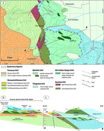
The LBF and UBF are separated by a sedimentary hiatus of middle Aptian – late Albian age (Nirta et al. Reference Nirta, Moratti, Piccardi, Montanari, Catanzariti, Carras and Papini2015). Near Koumaritsi village (Mount Iti, Figs 2, 5) the lowermost UBF sediments seal, through an unconformity surface, deformations of the underlying LBF turbiditic system (Nirta et al. Reference Nirta, Moratti, Piccardi, Montanari, Catanzariti, Carras and Papini2015).
(a) Geological map of the Koumaritsi area (modified after Marinos et al. Reference Marinos, Papastamatiou, Maratos, Melidonis, Andronopoulos, Tataris, Betoulis, Katsikatsos, Maragoudakis and Lalechos1967 and Richter Müller & Mihm, Reference Richter, Müller and Mihm1996), see Figure 2 for location. (b) Sketch structural cross-section of the Mount Iti area (modified after Wigniolle, Reference Wigniolle1977). (c) Cross-section across the Koumaritsi area.

The UBF in the studied area is represented by two lithostratigraphic units depicting a fining- and thinning-upwards sequence of Cenomanian–Coniacian age (Richter, Müller & Mihm, Reference Richter, Müller and Mihm1996; Nirta et al. Reference Nirta, Moratti, Piccardi, Montanari, Catanzariti, Carras and Papini2015). From the Santonian the UBF sequence shows in turn increasing breccia layers composed of neritic limestone, laterite and ophiolitic material that are then unconformably capped by post-nappe sequences consisting of Upper Cretaceous shallow carbonate (Second Mesoautochthonous Cycle; Wigniolle, Reference Wigniolle1977; Jacobshagen, Reference Jacobshagen1986; Nirta et al. Reference Nirta, Moratti, Piccardi, Montanari, Catanzariti, Carras and Papini2015). Steuber et al. (Reference Steuber, Gotzes, Raeder and Walter1993), although not differentiating the UBF succession from the Mesoautochthonous Complex, recognized a gradual transition from the deep-water clastic successions (namely the UBF) and the shallow-water carbonate succession of the Aptian–Coniacian portion of the Mesoautochthonous Complex (First Mesoautochthonous Cycle, see Section 3.c; Fig. 4).
Although deciphering palaeocurrents is complicated by superimposed tectonic events it is possible to assume a provenance from northern sectors for UBF turbidite currents.
3.a.3. Parnassus Unit
The Parnassus Unit consists of a shallow-water carbonate platform of Late Triassic – Late Cretaceous age that lies between the Pindos and Pelagonian units. It is limited to the north by the Sperchios fault system and to the south by the Corinth Gulf fault system (Fig. 2). These still active tectonic structures (Kilias et al. Reference Kilias, Tranos, Papadimitriou and Karakostas2008; Jolivet et al. Reference Jolivet, Labrousse, Agard, Lacombe, Bailly, Lecomte, Mouthereau and Mehl2010; Taylor et al. Reference Taylor, Weiss, Goodliffe, Sachpazi, Laigle and Hirn2011) are thought to have been inherited from lithospheric structures active in the Middle Triassic – Middle Jurassic period (Brunn, Reference Brunn1956; Fleury, Reference Fleury1980; Ferrière, Reference Ferrière1982; Ferrière, Baumgartner & Chanier, Reference Ferrière, Baumgartner and Chanier2016), thus driving the development of the Parnassus Platform as a distinct isopic zone within the eastern Adria continental margin.
The Parnassus Unit is composed of a 1800 m thick carbonate sequence resulting from continuous carbonate platform sedimentation from Triassic to Late Cretaceous times in a shallow-water marine environment (Renz, Reference Renz1955; Papastamatiou, Reference Papastamatiou1960; Celet, Reference Celet1962; Carras, Reference Carras1995).
Three main emersion episodes punctuated the shallow-water deposition resulting in karstification. These correspond to three major stratigraphic discontinuous horizons marked by bauxitic material, named b1 (upper Bathonian/lower Callovian – upper Oxfordian), b2 (upper Tithonian) and b3 (Aptian–lower Turonian) (Carras & Tselepidis, Reference Carras, Tselepidis, Solakius and Kati2001 and references therein). Mineralogical, geochemical and sedimentological studies indicate that bauxitic material derived from erosion, transport and reworking of lateritic bauxites developed at the expense of mafic and ultramafic rocks that suffered alteration in a warm climate (Aronis, Reference Aronis1955; Combes, Reference Combes1977, Reference Combes1979, Reference Combes1984; B. Clément, unpub. Ph.D. thesis, Univ. Lille, 1983; Valeton et al. Reference Valeton, Biermann, Reche and Rosenberg1987).
Pelagic sedimentation took place during latest Cretaceous time (Campanian–Maastrichtian) with deposition of platy limestone with chert. Condensed sedimentation followed during the Cretaceous–Tertiary (K–T) boundary with the formation of iron-phosphate-rich hardgrounds (Papastamatiou, Reference Papastamatiou1960; Celet, Reference Celet1962; Richter & Mariolakos, Reference Richter and Mariolakos1974a ,Reference Richter and Mariolakos b , Reference Richter and Mariolakos1975; Kalpakis, Reference Kalpakis1979; Solakius, Pomoni-Papaioannou & Marangoudakis, Reference Solakius, Pomoni-Papaioannou and Marangoudakis1989; Pomoni-Papaioannou & Solakius, Reference Pomoni-Papaioannou and Solakius1991; Carras & Tselepidis, Reference Carras, Tselepidis, Solakius and Kati2001). Sedimentation resumed in Paleocene time in a pelagic environment with deposition of thin-bedded limestone (Gregou, Solakius & Pomoni-Papaioannou, Reference Gregou, Solakius and Pomoni-Papaioannou1994) followed by a thick succession of red marls (‘Pre-Flysch’; Gregou, Reference Gregou1996; Gregou & Solakius, Reference Gregou and Solakius1997), and finally topped by siliciclastic flysch of late Paleocene–Eocene age. The diachronous establishment of pelagic sedimentation in the Parnassus Zone was a consequence of tectonics at the K–T transition that produced pronounced relief with horst and graben geometry (Richter & Mariolakos, Reference Richter and Mariolakos1975; Gregou, Solakius & Pomoni-Papaioannou, Reference Gregou, Solakius and Pomoni-Papaioannou1994; Richter et al. Reference Richter, Müller, Hottinger and Risch1995). The seafloor was then levelled in early Eocene time just before flysch sedimentation (Gregou, Reference Gregou1996).
The western transition of the Parnassus Zone towards the Pindos pelagic basin occurs with the interposition of the Vardoussia and Penteoria units, characterized by deeper slope and sea-mount facies, respectively (Papastamatiou, Reference Papastamatiou1960; Papastamatiou et al. Reference Papastamatiou, Tataris, Katsikatsos and Maragoudaxis1962a ; Celet, Reference Celet1962, Reference Celet1979; R. Ardaens, unpub. Ph.D. thesis, Univ. Lille, 1978; Fleury, Reference Fleury1980). The Vardoussia Unit comprises a Middle Triassic volcanic event related to continental extension (Lefèvre et al. Reference Lefèvre, Cabanis, Ferrière, Thiebault and Platevoet1993; Pe-Piper, Reference Pe-Piper1998) followed by pelagic carbonate and siliceous deposits of Jurassic–Cretaceous age, and finally topped by Eocene siliciclastic flysch. Neritic sedimentation was limited temporally (Triassic, under the Penteoria condensed series). Coarse breccia deposits containing shallow-water limestone clasts were recognized at different stratigraphic levels within the pelagic deposition, testifying to the vicinity of the dismantling carbonate platform (i.e. the Parnassus Platform; R. Ardaens, unpub. Ph.D. thesis, Univ. Lille, 1978; Fig. 4).
West of the Parnassus/Vardoussia units the Pindos Unit consists of Triassic to Upper Cretaceous pelagic carbonate, radiolarite and shale, overlain by Paleocene–Eocene syn-orogenic flysch (Pindos Flysch; Richter, Mariolakos & Risch, Reference Richter, Mariolakos, Risch, Closs, Roeder and Schmidt1978). In the Etolia region, west of the frontal thrust of the Vardoussia Unit above the Pindos Unit, the Pindos Flysch encloses a continuous level of slide blocks and debris flow deposits bearing ophiolitic material (Celet, Reference Celet1962, Reference Celet1979; C. Beck, unpub. Ph.D. thesis, Univ. Science and Technology, Lille, 1975; Fig. 4). Where preserved by Tertiary tectonic movements, the relationships of ophiolitic mass flow deposits with the Pindos Flysch are clearly stratigraphic. Even if the larger ophiolitic blocks show unclear relationships with the flysch, the presence of ophiolite-bearing debris flow deposits closely associated with the huge blocks permits considering the latter also as slide blocks (Beck, Reference Beck1980). Alternatively, this ophiolite-bearing material is regarded as a remnant of the closure, during the Tertiary compressive phases, of a small strand of the Pindos ‘Ocean’ (Kerassia-Milia ‘Ocean’; Robertson et al. Reference Robertson, Clift, Degnan and Jones1991; Robertson & Degnan, Reference Robertson and Degnan1993; Pe-Piper & Hatzipanagiotou, Reference Pe-Piper and Hatzipanagiotou1993) that bordered to the west the Parnassus Platform, which is thus isolated as a microcontinent, the main branch of the Pindos ‘Ocean’ being located to the east of it (Robertson & Degnan, Reference Robertson and Degnan1993).
Further moving towards the west, thus towards the undeformed Adria margin, the Pindos Unit structurally overlies the Gavrovo–Tripolitza Unit in the west that, in turn, overthrusts the Ionian Unit, and this latter thrusts onto the Apulian Unit.
3.b. Ocean-derived units
Obduction is the most widely accepted emplacement mechanism for the ophiolitic bodies widespread throughout the Dinaric–Hellenic orogen. A major constraint for this kind of process is the presence at the base of the ultramafic mantle section of slices of HT–LP metamorphic rocks (amphibolite sole). Metamorphism is assumed to have been acquired by underplated units soon after the inception of intraoceanic thrusting of a young and exceptionally hot ophiolite nappe originated near the spreading axis (Spray et al. Reference Spray, Bébien, Rex, Roddick, Dixon and Robertson1984; Carosi et al. Reference Carosi, Cortesogno, Gaggero and Marroni1996; Searle & Cox, Reference Searle and Cox1999; Dimo-Lahitte, Monié & Vergély, Reference Dimo-Lahitte, Monié and Vergély2001; Myhill, Reference Myhill, Wakabayashi and Dilek2011).
Continuing thrusting of the ophiolite nappe was also linked with the production of a ‘tectono-sedimentary mélange’ supplied by both the ophiolite thrust sheets and from off-scraping of pelagic shaly-siliceous sediments from the overthrust ocean bottom. Major slide block and tectonic slivers originated from the ophiolite thrust sheets and scraped-off sediments from the underplating of both oceanic and continental margin units were also embedded in the mélange matrix. Today, ophiolites and obduction-related mélange are arranged along two main belts separated by the Pelagonian continental units and its continuation to the north (i.e. the Korab Unit in Albania and Drina–Ivanjica Unit in Serbia; Fig. 1). However, this distinction is not evident in Bosnia where the Drina–Ivanjica and Durmitor units are overthrust by a unique and continuous ophiolite nappe (Schmid et al. Reference Schmid, Bernoulli, Fügenschuh, Matenco, Schefer, Schuster, Tischler and Ustaszewski2008).
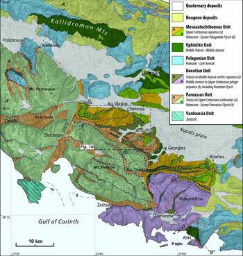
In the studied area the Ophiolitic Unit is mostly represented by sheared shaly-sandy matrix chaotically enveloping rock fragments of both oceanic and continental origin (Ophiolitic Mélange) and dismembered portions of the ophiolite nappe mainly represented by serpentinized harzburgite and lherzolite. The main ophiolite occurrences are located in Mount Iti, the Kallidromon Mountains and near Aliki Village on the Corinth Gulf (Figs 2, 6). Large slivers of amphibolite sole were observed within the ophiolitic mélange in a small abandoned quarry near Agios Georgios village and in small blocks east of Agia Triada village (Fig. 6). Amphibolite sole underlies the ophiolite nappe of Mount Iti (northwest of Pyra village) and in the Gerania Mountains (Kaplanis et al. Reference Kaplanis, Koukouvelas, Xypolias and Kokkalas2013).
Tectonic–geological map of Boeotia (location in Fig. 2). New data and observations integrate and modify former mapping by Papastamatiou et al. (Reference Papastamatiou, Tataris, Vetoulis, Katsikatsos, Lalechos and Eleutheriou1962b , Reference Papastamatiou, Tataris, Kounis, Maragoudaxis, Monopolis, Albadakis and Koukouzos1971), Maratos, Rigopoulos & Athanassiou (Reference Maratos, Rigopoulos and Athanassiou1965, Reference Maratos, Rigopoulos and Athanassiou1967) and B. Clément, unpub. Ph.D. thesis, Univ. Lille (1983). DSTF – Distomon Fault; ATRF – Agia Triada Fault; ALKF – Aliki Fault.
3.c. Upper Cretaceous sedimentation (Mesoautochthonous Complex)
A thick sequence of Aptian to Upper Cretaceous shallow-water carbonates sealed older deformations recorded in the tectonic stack composed by the ophiolitic, Pelagonian and Boeotian units. These sediments, known as the Mesoautochthonous Complex (Jacobshagen, Reference Jacobshagen1986) or sediments of the ‘Cretaceous transgression’ (Photiades et al. Reference Photiades, Carras, Bortolotti, Fazzuoli and Principi2007; Fazzuoli et al. Reference Fazzuoli, Menna, Nirta, Carras and Principi2008), are widespread in all of the Hellenic–Dinaric Belt with a similar tectonic position and sedimentation age. The Mesoautochthonous Complex also unconformably covers tectonized remnants of an older carbonate platform possibly sedimented above the ophiolite nappe during obduction and seals the syn-obduction deformations they recorded (Bortolotti et al. Reference Bortolotti, Carras, Chiari, Fazzuoli, Photiades and Principi2004a ; Fazzuoli & Carras, Reference Fazzuoli and Carras2007). The existence of syn-obduction Late Jurassic to Valanginian carbonate platforms is testified to throughout the Dinaric–Hellenic orogen by tectonized remnants above ophiolites (Bortolotti et al. Reference Bortolotti, Carras, Chiari, Fazzuoli, Photiades and Principi2004a ; Schlagintweit et al. Reference Schlagintweit, Gawlick, Missoni, Lein, Hosha, Sudar, Ercegovac and Grubic2006; Photiades et al. Reference Photiades, Carras, Bortolotti, Fazzuoli and Principi2007) and, in most of the cases, by clasts and slide blocks resedimented, after total dismantling episodes, within the ophiolitic mélange, or within Late Jurassic – Early Cretaceous foreland basins (e.g. the Pogari Formation in Serbia, Firza Flysch in Albania, Lower Boeotian Flysch in Greece; Blanchet et al. Reference Blanchet, Durand Delga, Moullade and Sigal1970; Schlagintweit et al. Reference Schlagintweit, Gawlick, Missoni, Hosha, Lein and Frisch2008; Nirta et al. Reference Nirta, Moratti, Piccardi, Montanari, Catanzariti, Carras and Papini2015).
Based on their age, substratum and main sequence boundaries, we propose a subdivision of the Mesoautochthonous Complex into two main sedimentary cycles. Sedimentation above the ophiolite nappe and the Pelagonian Unit generally starts in Aptian/Albian–Cenomanian times above a level of karstic or redeposited laterites lasting, without regional unconformities, until Coniacian–Santonian times (First Mesoautochthonous cycle, MES1; B. Clément, unpub. Ph.D. thesis, Univ. Lille, 1983; Photiades et al. Reference Photiades, Carras, Bortolotti, Fazzuoli and Principi2007; Fazzuoli & Carras, Reference Fazzuoli and Carras2007). A younger sedimentation cycle of late Santonian – Maastrichtian age, also underlined by an unconformity, is present above the ophiolites and the UBF (Second Mesoautochthonous cycle, MES2; E. Wigniolle, unpub. Ph.D. thesis, Univ. Lille, 1975; Steuber et al. Reference Steuber, Gotzes, Raeder and Walter1993).
In Boeotia and Attica, stratigraphic contacts of the MES1 were described in the Avlona area (northern Attic region), above ophiolites (B. Clément, unpub. Ph.D. thesis, Univ. Lille, 1983), and in the Aliartos (Fig. 2) and Mandra-Megara areas (Elefsina Gulf, Attica region) above the Pelagonian carbonates (B. Clément, unpub. Ph.D. thesis, Univ. Lille, 1983; Steuber et al. Reference Steuber, Gotzes, Raeder and Walter1993). The MES1 is coeval and partially heteropic with the UBF (Steuber et al. Reference Steuber, Gotzes, Raeder and Walter1993) that in turn unconformably seals the deformed Tithonian–Aptian LBF (Nirta et al. Reference Nirta, Moratti, Piccardi, Montanari, Catanzariti, Carras and Papini2015) (Fig. 4).
Primary contacts of the MES2 above the UBF were preserved in Mount Iti (E. Wigniolle, unpub. Ph.D. thesis, Univ. Lille, 1975) (Fig. 5) and above ophiolites located northeast of Levadhia (Dionysos–Pavlos area; Steuber et al. Reference Steuber, Gotzes, Raeder and Walter1993; Fig. 2). In the Levadhia and Jerolekas (northern Parnassus; Fig. 2) areas the basal primary contact of the MES2 is underlined by ophiolite-bearing conglomerate deposits with abundant laterite clasts and a rudist fauna of Santonian–Campanian age (Steuber, Raeder & Walter, Reference Steuber, Raeder and Walter1994; Steuber, Reference Steuber1999; Morycowa & Marcopoulou-Diacantoni, Reference Morycowa and Marcopoulou-Diacantoni2002). Conglomerates unconformably cover the lower Cenomanian MES1 limestone after an episode of emersion and laterization (Steuber, Raeder & Walter, Reference Steuber, Raeder and Walter1994).
Similarly to the Parnassus Unit, reddish marls and shale of middle–late Paleocene age underlie the siliciclastic turbiditic sedimentation of late Paleocene–Eocene age (Pelagonian Flysch) above the Campanian–Maastrichtian limestone of the MES2 (Wigniolle, Reference Wigniolle1977; Richter, Müller & Risch, Reference Richter, Müller and Risch1996).
4. Biostratigraphic data
With the aim of refining the age of key stratigraphic events, sampling was performed in the Pelagonian, Boeotian and Parnassus units. Radiolarian, nannofossil and foraminiferal associations were analysed after sampling the following stratigraphic units in the Iti, Kallidromon, Parnassus and Boeotia areas (Figs 2, 4): (i) mass flow deposits on top of the Jurassic carbonates of the Pelagonian Unit; (ii) Lower Boeotian Flysch (LBF, Boeotian Unit); (iii) Mesoautochthonous sequences; (iv) Parnassus Flysch (Parnassus Unit), Pelagonian Flysch (Pelagonian Unit).
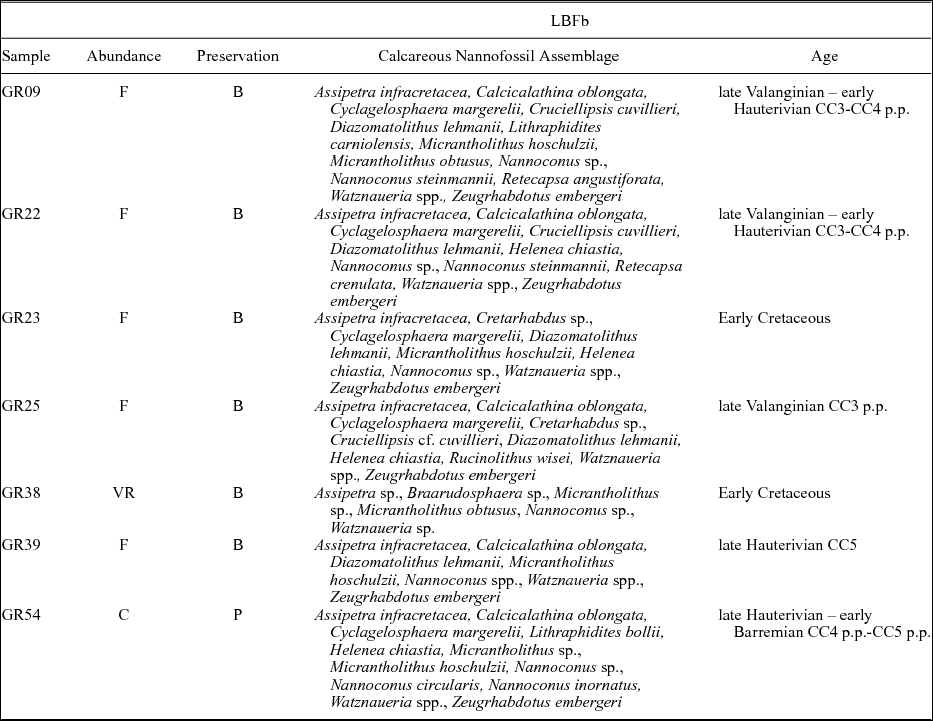
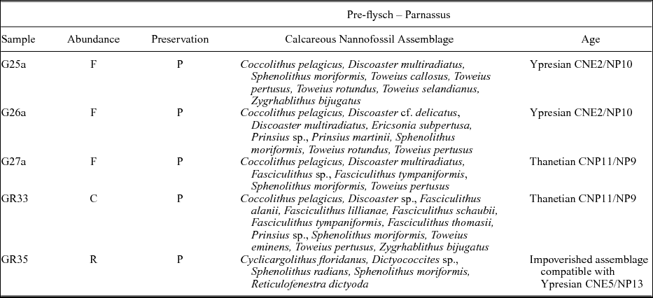
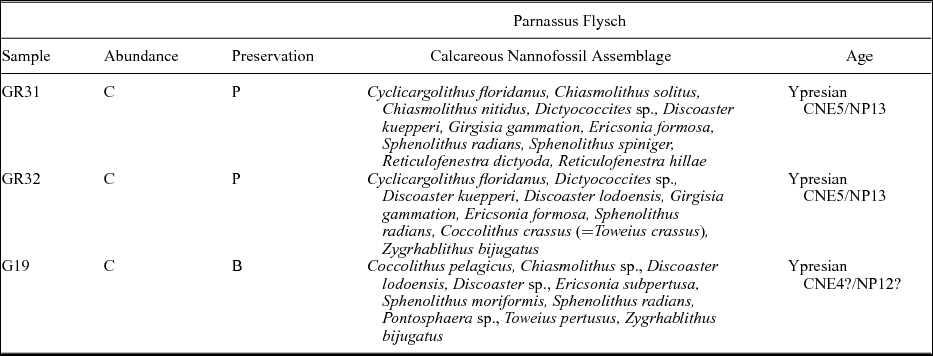
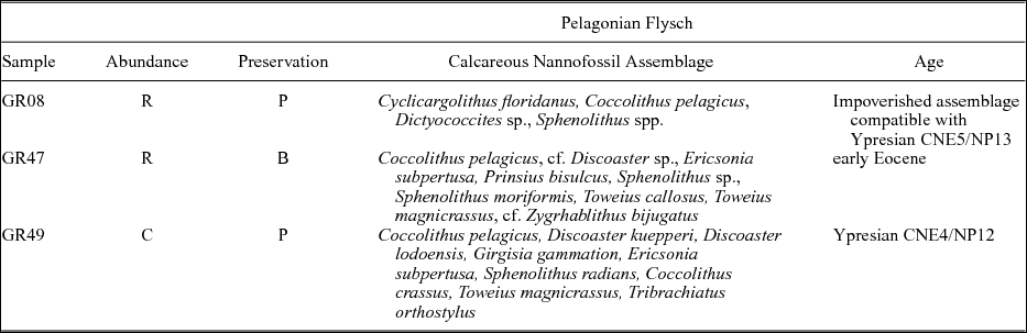
The biozonations adopted for dating the calcareous nannofossil assemblages use the CNP and CNE zones proposed by Agnini et al. (Reference Agnini, Fornaciari, Raffi, Catanzariti, Pälike, Backman and Rio2014) with the corresponding standard NP zones of Martini (Reference Martini1971) for the Paleocene and Eocene, and the CC zones of Sissingh (Reference Sissingh1977) for the Early Cretaceous period. Tables 1–6 report the calcareous nannofossil taxa recognized according to the taxonomy proposed by Perch-Nielsen (Reference Perch-Nielsen, Bolli, Saunders and Perch-Nielsen1985a ,Reference Perch-Nielsen, Bolli, Saunders and Perch-Nielsen b ) and Bown (Reference Bown1998). Total abundance in every sample was categorized as follows: common – C ≥ 10 specimens per FOV (field of view); frequent/few – F ≥ 1 specimens per FOV; rare/very rare – R/VR ≤ 1 specimens per FOV. Quantitative analyses were performed only in samples GR69–70 where at least 300 specimens were counted. Preservation was evaluated as between poor (P) and bad (B), on account of both heavy etching and dissolution.
Nannofossil associations in the LBFa Unit

Nannofossil associations in the LBFb Unit

Nannofossil associations in the pre-flysch facies of the Parnassus Flysch

Nannofossil associations in the Parnassus Flysch

Nannofossil associations in the pre-flysch facies of the Pelagonian Flysch

Nannofossil associations in the Pelagonian Flysch

4.a. Siliceous deposits and mass flow deposits on top of the Jurassic carbonates of the Pelagonian Unit (Iti and Kallidromon areas)
In the Iti area, E. Bléhaut (unpub. Ph.D. thesis, Univ. Lille, 1975) and E. Wigniolle (unpub. Ph.D. thesis, Univ. Lille, 1975) described several sections of detritic material stratigraphically topping the Pelagonian limestone. On the whole, the sequence consists of Upper Jurassic neritic limestone passing upwards to siliceous limestone, radiolarite and shale (c. 10 m thick), thin-bedded turbidites (c. 20 m thick) and finally decametric levels of ophiolite-bearing cohesive debris flow deposits.
Three samples rich in radiolarian fauna (samples G03, G04, G05; Fig. 7) were collected on the northern flank of Tsikeri Mountain (about 2 km east of Pyra village; 38° 44′ 57.1″ N, 22° 17′ 54.2″ E; Fig. 2), in an overturned sequence characterized by a thin-bedded turbidite stratigraphically overlain by metre-thick cohesive debris flow deposits containing ophiolite material. The turbidite strata are geometrically overlain, through a tectonic contact, by siliceous limestone and bedded limestone of the Pelagonian Platform. In turn the mass flow sequence tectonically overlies the Parnassus Flysch with interposing slices of Boeotian Flysch (Fig. 5b). Unfortunately, the samples are always characterized by poor preservation of the radiolarian forms hampering dating. Nevertheless, the common presence in these samples of the nannofossil Watznaueria barnesiae and the lithostratigraphic similarities with other well-dated sections (see Baumgartner & Bernoulli, Reference Baumgartner and Bernoulli1976) allow us to tentatively attribute a Late Jurassic – Early Cretaceous age to these deposits.
Schematic lithostratigraphic columns of the sampled units. Samples in bold are analysed in this work; samples in italic were analysed in Nirta et al. (Reference Nirta, Moratti, Piccardi, Montanari, Catanzariti, Carras and Papini2015). 1 – bedded limestone; 2 – massive limestone; 3 – cherty limestone; 4 – shale and fine-grained limestone; 5 – calcarenites; 6 – radiolarite and shale; 7 – shale; 8 – fine-grained sandstone and shale; 9 – coarse-grained sandstone; 10 – cohesive and granular debris flow deposit; 11 – ophiolite-bearing mass flow deposits and slide blocks; 12 – laterite. Dating of radiolarian chert from the Pelagonian Unit is expressed as the minimum age range.

In the Kallidromon Mountains foothills, 1.4 km west of Xyliki village, siliceous limestone and shaly-radiolarite strata top a well-bedded Pelagonian limestone succession. This is interrupted by the thrust of the above ophiolitic mélange and ophiolite nappe (Fig. 6 and cross-section A–A′ in Fig. 8). Samples were collected in the siliceous limestone (GR63, GR64, GR66) and in the shaly-radiolarite section (GR65, GR67, GR68) (Fig. 7).
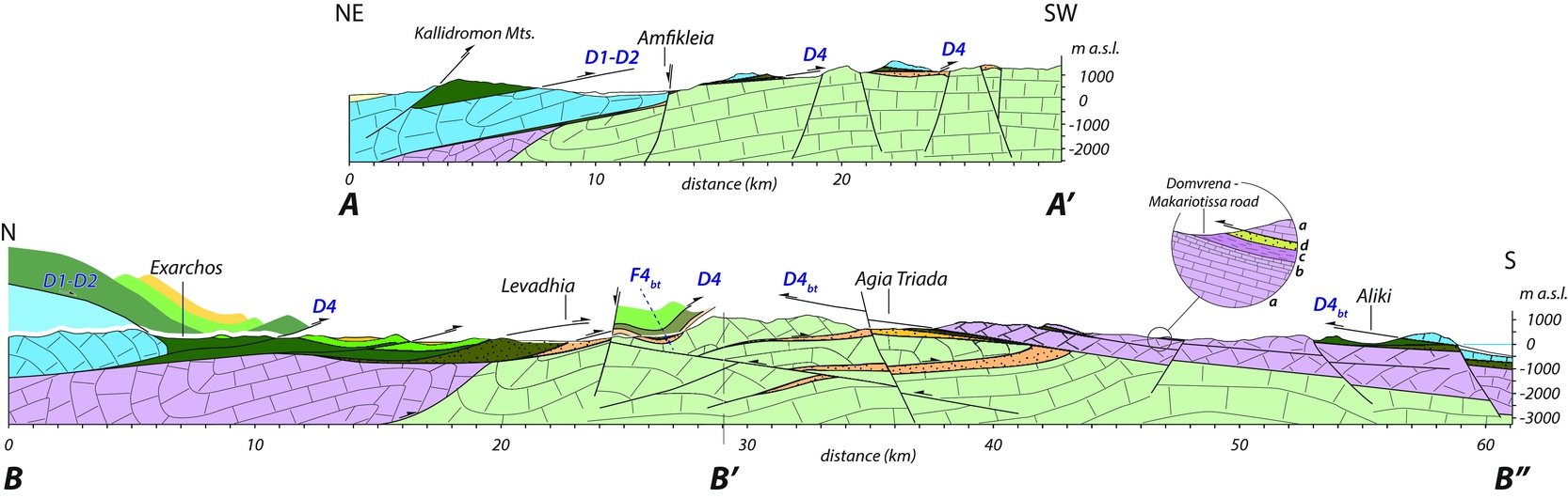
Regional geological cross-sections across the Boeotia region (see Fig. 6 for location and legend). The basal portion of the Lower Boeotian Flysch cropping out in the Domvrena–Makariotissa area is described in the circle: a – Triassic – Lower Jurassic neritic limestone; b – Middle–Upper Jurassic pelagic limestone and siliceous limestone; c – Upper Jurassic radiolarian cherts and shale; d – Upper Jurassic ophiolite-bearing mass flows, shales and marlstones (Lower Boeotian Flysch) (modified after B. Clément, unpub. Ph.D. thesis, Univ. Lille, 1983). D1, D2, D4, D4bt – tectonic contacts with deformation phase attribution (see Section 5.c for details); F4bt – D4bt deformation phase megafold.

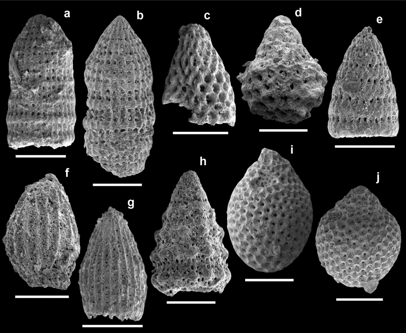
The following radiolarian assemblage was obtained from sample GR66: Archaeodictyomitra apiarium (Rüst), Archaeodictyomitra aff. apiarium (Rüst), Archaeodictyomitra cf. apiarium (Rüst), Archaeodictyomitra sp., Campanomitra cf. tuscanica (Chiari, Cortese & Marcucci), Cinguloturris (?) sp., Crococapsa sp., Loopus cf. blabla (Schaaf) sensu Dumitrica, Immenhauser & Dumitrica-Jud (Reference Dumitrica, Immenhauser and Dumitrica-Jud1997), Protunuma sp., Thanarla patricki gr. (Kocher), Transhsuum sp., Xitus cf. normalis (Wu & Li), Xitus (?) sp., Zhamoidellum ovum Dumitrica, Zhamoidellum cf. ovum Dumitrica, Zhamoidellum cf. ventricosum Dumitrica. This assemblage allow the attribution of a middle Callovian – early Oxfordian to late Kimmeridgian – early Tithonian age (UAZ. 8–11; UA zones after Baumgartner et al. Reference Baumgartner, Bartolini, Carter, Conti, Cortese, Danelian, De Wever, Dumitrica, Dumitrica-Jud, Goričan, Guex, Hull, Kito, Marcucci, Matsuoka, Murchey, O'Dogherty, Savary, Vishnevskaya, Widz, Yao, Baumgartner, O'Dogherty, Goričan, Urquhart, Pillevuit and Wever1995a ) based on the occurrence of Archaeodictyomitra apiarium (Rüst) with Zhamoidellum ovum Dumitrica (ranges after Baumgartner et al. Reference Baumgartner, O'Dogherty, Goričan, Dumitrica-Jud, Dumitrica, Pillevuit, Urquhart, Matsuoka, Danelian, Bartolini, Carter, De Wever, Kito, Marcucci, Steiger, Baumgartner, O'Dogherty, Goričan, Urquhart, Pillevuit and De Wever1995b ; Smuc & Goričan, Reference Smuc and Goričan2005) (Fig. 9).
Scanning electron micrographs of radiolarians from sample GR66 (scale bar = 50 µm). (a) Archaeodictyomitra apiarium (Rüst); (b) Archaeodictyomitra aff. apiarium (Rüst); (c) Campanomitra cf. tuscanica (Chiari, Cortese & Marcucci); (d) Crococapsa sp., (e) Loopus cf. blabla (Schaaf) sensu Dumitrica, Immenhauser & Dumitrica-Jud (Reference Dumitrica, Immenhauser and Dumitrica-Jud1997); (f) Protunuma sp.; (g) Thanarla patricki gr. (Kocher); (h) Xitus cf. normalis (Wu & Li); (i) Zhamoidellum ovum Dumitrica; (j) Zhamoidellum cf. ventricosum Dumitrica.

4.b. Lower Boeotian Flysch
Biostratigraphic investigations in the Levadhia area allow the refinement of the ages of the lithostratigraphic Units A and B of the Lower Boeotian Flysch (LBFa and LBFb; see Nirta et al. Reference Nirta, Moratti, Piccardi, Montanari, Catanzariti, Carras and Papini2015 for details). The lowermost portion of unit LBFa, detached from its substratum, was sampled 4.5 km west of Levadhia (Fig. 10). According to Bornemann, Aschwer & Mutterlose (Reference Bornemann, Aschwer and Mutterlose2003), the nannofossil assemblages in samples GR69–70 (Fig. 7) allow the attribution of a middle–late Tithonian to early Berriasian age to the older sediments of the LBF on account of the dramatic increase of nannoconids (from 6 % to above 40 %) and the contemporary decrease of Conusphaera mexicana (from above 30 % to 1 %) and Polycostella beckmannii (from above 7 % to below 1 %) (see Table 1). The samples collected in unit LBFb in different outcrops located along the Levadhia–Arachova road (samples GR09, GR22–23, GR25, GR38–39, GR54; Fig. 7) allow us to constrain an age spanning from late Valanginian to the Hauterivian–Barremian boundary, based on the presence of Rucinolithus wisei, Calcicalathina oblongata, Cruciellipsis cuvillieri, common nannoconids and Lithraphidites bollii (zones CC3–CC5 p.p.; see Table 2).
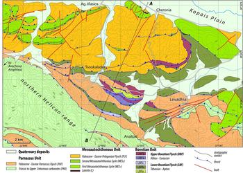
Geological map of the Levadhia area (location in Fig. 6).

4.c. The Mesoautochthonous Complex
This unit was sampled northwest of Levadhia, in overturned sections linked with imbricate thrusts exposed from the Distomon Fault to Cheronia village (Figs 10, 11).
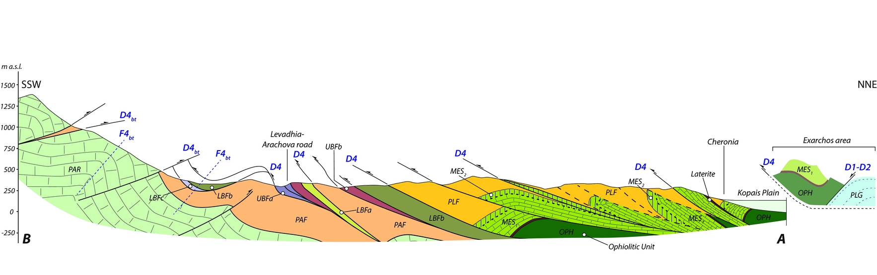
Geological cross-section along the Helicon range – Kopais plain transect (Levadhia area). On the right is reported the schematic structural profile of the Exarchos area. See Figure 10 for location and legend.

In the Cheronia area the stratigraphically lowermost levels of the Mesoautochthonous Complex are represented by platform material resedimented in a slope environment with a reddish bauxitic matrix (sample GR04; Fig. 7). The fossil assemblage consisting of Orbitolina cf. conica (D'Archiac), Ticinella cf. roberti Gandolfi and abundant Radiolitidae, Caprinidae, bryozoa and echinoderm fragments allows the attribution of a late Albian age to the penecontemporaneous bioclasts. This datum is in good accordance with the contemporaneous subaerial exposure and laterization of the Parnassus Platform and of wide areas of the more external Pelagonian Platform. The sampled section possibly represents the base of the First Mesoautochthonous sedimentary cycle (MES1).
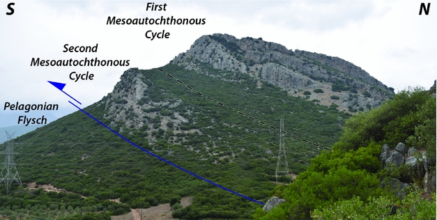
The carbonate levels sampled in another overturned section exposed further west, near the Distomon Fault (DSTF in Fig. 6) and just above the tectonic contact with the underlying Pelagonian Flysch (Fig. 12), are attributed a late Campanian – Maastrichtian age on the basis of the following microfauna assemblage: Siderolites calcitrapoides Lamarck, Cuneolina pavonia D'Orbigny (fragment), Lepidorbitoides sp., Orbitoides sp., Rugoglobigerina sp., Griphoporella? sp., fragments of Corallinaceae, Radiolitidae, stromatoporoids and echinoderms (sample GR46; Fig. 7). Upwards, the sedimentation shifts towards pelagic conditions with deposition of marls and marly limestones. A single sample (GR45) collected in the marly sequence gave the following nannofossil assemblage: Coccolithus pelagicus, Chiasmolithus sp., Chiasmolitus danicus, Bomolithus sp., Ericsonia subpertusa, Ericsonia robusta, Fasciculithus sp., Fasciculithus billii, Fasciculithus janii, Fasciculithus pileatus, Fasciculithus tympaniformis, Fasciculithus ulii, Heliolithus sp., Prinsius bisulcus, Sphenolithus sp., Sphenolithus anarrhopus, Sphenolithus moriformis, Thoracosphaera sp., Toweius pertusus, Toweius rotundus. This association allows the attribution of a late Paleocene age to this pelagic transition (Selandian–Thanetian Zone CNP8, corresponding to zones NP5 p.p.–NP6). As a whole, this sequence is possibly attributable to the upper part of the Second Mesoautochthonous sedimentary cycle (MES2).
Overturned section of the Mesoautochthonous Complex (Levadhia area; 38° 28′ 33″ N; 22° 44′ 10″ E).

4.d. Parnassus Flysch
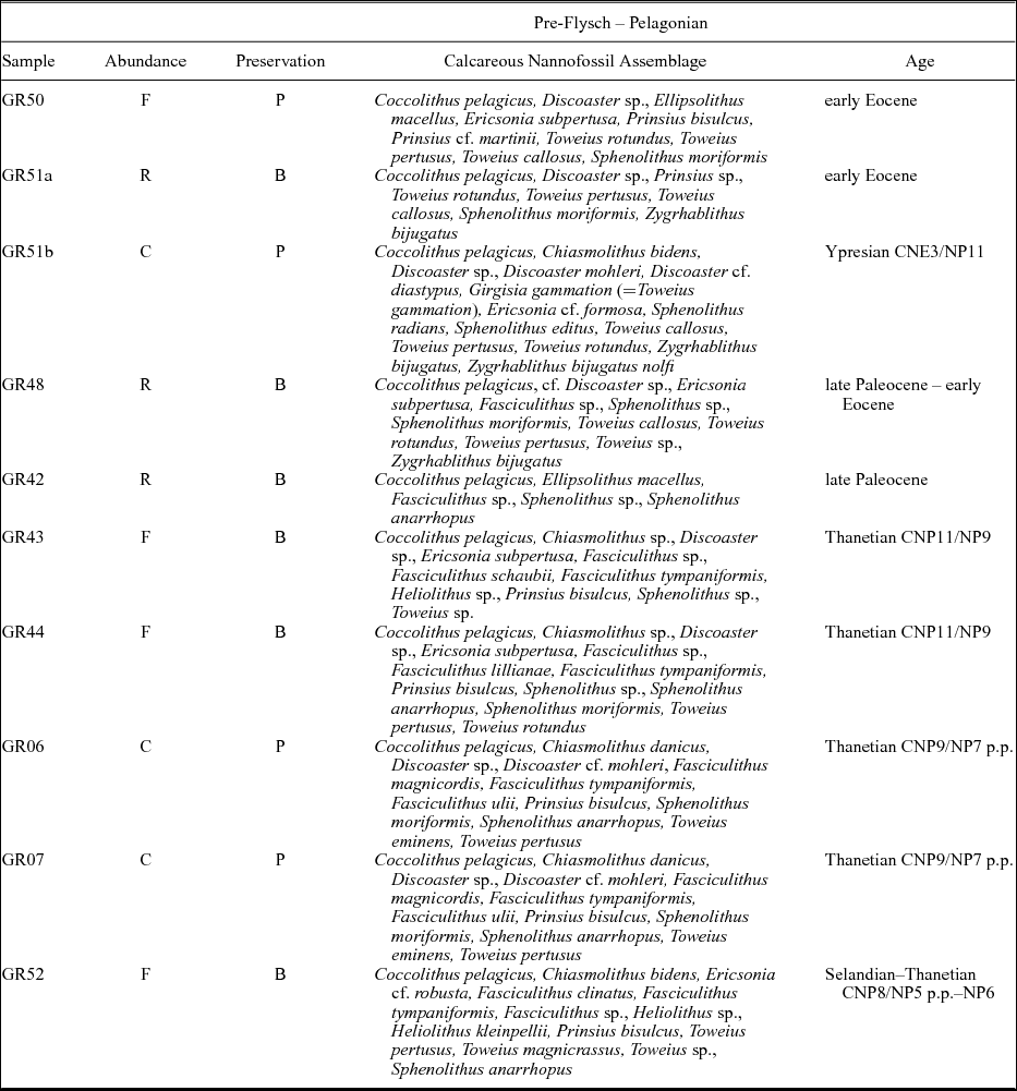
Samples were collected in the lower part of the pre-flysch facies near the contact with the carbonate substratum at several sites on Mount Parnassus and in the northern Helicon range (GR25a–27a, GR31–33, GR35) (Figs 4, 6, 7). Nannofossil assemblages in the pre-flysch facies are attributable to the latest Paleocene – earliest Eocene. On Mount Parnassus, late Thanetian – early Ypresian zones CNP11 and CNE2, corresponding to zones NP9–NP10, were documented by the occurrence and absence of Fasciculithus spp., respectively (see Table 3). The early Eocene was recorded in the Helicon range, where late Ypresian Zone CNE5, corresponding to Zone NP13, was documented by the common occurrence of the first specimens belonging to Noelaerhabdaceae (Cyclicargolithus floridanus, Dictyococcites sp. and Reticulofenestra dictyoda; see Table 3). The transition to frank flysch sedimentation occurred during middle–late Ypresian zones CNE4 and CNE5 (corresponding to zones NP12 and NP13) characterized by the presence of common specimens referable to Toweius and Noelaerhabdaceae (see Table 4).
The obtained results are in agreement with the diachronous establishment of pelagic conditions in the Parnassus Zone after the Late Cretaceous tectonic events that levelled the seafloor bathymetry before flysch deposition (Gregou, Reference Gregou1996).
4.e. Pelagonian Flysch
The Pelagonian Flysch was sampled in several sites in the hills located between Levadhia and Cheronia villages and nearby Davlia village (Fig. 6). In this area the Pelagonian Flysch is both exposed in its primary position at the top of the limestone of the Mesoautochthonous Complex or tectonically below it. In general, the Mesoautochthonous Complex and Pelagonian Flysch are overthrust southwards, through out-of-sequence thrusts, above the Boeotian and Parnassus units.
Nannofossil assemblages from the reddish marls at the base of the flysch sequence (pre-flysch facies; samples GR06–07, GR42–44, GR48, GR50–51a/b; Fig. 7) indicate a late Paleocene – early Eocene age (see Table 5). The Selandian/Thanetian Zone CNP8 (corresponding to zones NP5 p.p.–NP6) was documented by the occurrence of Heliolithus kleinpellii. The Thanetian Zone CNP9 (corresponding to Zone NP7 p.p.) was established on the presence of Discoaster cf. mohleri and the absence of H. kleinpellii, while the late Thanetian Zone CNP11 (corresponding to Zone NP9) was recognized by the presence of Fasciculithus lillianae. The early Ypresian Zone CNE3 (corresponding to zones NP10 p.p.–NP11) was identified by the presence of Girgisia gammation (Toweius? gammation) and Sphenolithus radians. Biostratigraphic results point to an early Eocene age for the shaly-arenaceous and conglomeratic flysch facies (samples GR08, GR47, GR49); Ypresian zones CNE4 and CNE5 (corresponding to zones NP12 and NP13) were recognized, respectively, by the occurrence of Tribrachiatus orthostylus and the common presence of specimens belonging to Noelaerhabdaceae (see Table 6).
5. Structural analysis
5.a. Data collection and methods
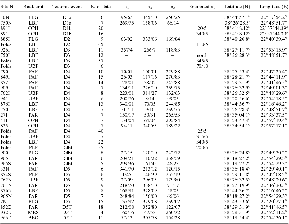
The structural analysis aimed to discriminate structures related to the different stages of the tectonic evolution of the area. The relative timing of deformation was constrained by cross-cutting relationships observed in all rock units, both at the map and outcrop scale. Mesoscopic structural observations were collected at several sites within the study area, focusing on the major tectonic contacts. Fault-slip data were analysed in order to derive the palaeostress field associated with the stages of regional deformation. Palaeostress analysis was performed using the Fault software developed by Caputo & Caputo (Reference Caputo and Caputo1988) that calculates the orientation of the stress tensors σ1, σ2, and σ3 (where σ1 is the maximum compressional stress and σ1>σ2>σ3) through the dihedron angle inversion method of Angelier & Mechler (Reference Angelier and Mechler1977). Basic limitations and assumptions of the palaeostress analysis were taken into account. Table 7 presents the parameters of the reduced stress tensors as well as the estimated shortening directions derived from the structural analysis of fold axes. In the next sections, the tectonic implications of these parameters will be interpreted and the results will be integrated into the regional geodynamic evolution of the study area.
Mesoscopic structural field data from sites of measurement of the study area

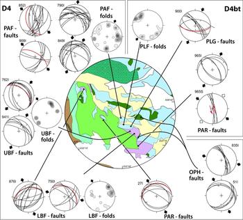
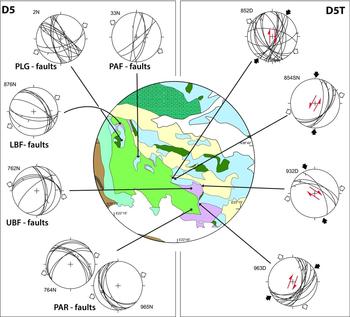
The σ1, σ2, and σ3 axes have been computed applying the dihedron angle method to fault populations (Angelier & Mechler, Reference Angelier and Mechler1977) through the ‘FAULT’ software of Caputo & Caputo (Reference Caputo and Caputo1988). Fold axes, grouped according to both tectonic event and rock unit, allowed a rough estimate of the maximum horizontal palaeostress axis. Abbreviations: OPH – Ophiolitic Unit: mélange; PLG – Pelagonian Unit limestone; PLF – Pelagonian Flysch; LBF – Lower Boeotian Flysch; UBF – Upper Boeotian Flysch; PAR – Parnassus Unit limestone; PAF: Parnassus Flysch; BEO – Boeotian Unit limestone; MES – Mesoautochthonous Complex limestone.
The results of the field-based structural work are synthesized in a new geological–structural map and cross-section of the Levadhia region (Figs 10, 11) and a tectonic sketch map and two cross-sections across the whole studied area (Figs 6, 8). Some of the collected orientation data are summarized in equal-area plots.
5.b. Tectonic setting and major tectonic structures
The studied area is characterized by a complex structural evolution, deriving from the superposition of several tectonic phases, related to obduction, continental collision, subducting slab retreat and gravitational collapse of over-thickened crust (e.g. Bernoulli & Laubscher, Reference Bernoulli and Laubscher1972; Robertson & Dixon, Reference Robertson, Dixon, Dixon and Robertson1984; Jacobshagen, Reference Jacobshagen1986; Mercier et al. Reference Mercier, Sorel, Vergély and Simeakis1989; Le Pichon et al. Reference Le Pichon, Chamot-Rooke, Lalleman, Noomen and Veis1995; Ricou et al. Reference Ricou, Burg, Godfriaux and Ivanov1998; Brun & Faccenna, Reference Brun and Faccenna2008).
Tectono-metamorphic events accompanied this long-lasting evolution (Fig. 4). Middle Jurassic HT–LP metamorphism is recorded at the base of the obducting nappe (Roddick, Cameron & Smith, Reference Roddick, Cameron and Smith1979; Spray & Roddick, Reference Spray and Roddick1980; Dimo-Lahitte, Monié & Vergély, Reference Dimo-Lahitte, Monié and Vergély2001) then followed by three major tectono-metamorphic events in the eastern Pelagonian Zone: (i) Early Cretaceous upper-greenschist to blueschist facies metamorphism and anatexis events (Barton, Reference Barton1976; Yarwood & Dixon, Reference Yarwood and Dixon1977; Schermer, Lux & Burchfiel, Reference Schermer, Lux and Burchfiel1990; Lips, White & Wijbrans, Reference Lips, White and Wijbrans1998; Schenker et al. Reference Schenker, Burg, Kostopoulos, Moulas, Larionov and Von Quadt2014); (ii) Late Cretaceous blueschist facies metamorphism (Lips, White & Wijbrans, Reference Lips, White and Wijbrans1998; Lips, Wijbrans & White, Reference Lips, Wijbrans, White, Durand, Jolivet, Horváth and Séranne1999); (iii) Paleocene–Eocene blueschist to greenschist facies metamorphism (Schermer, Lux & Burchfiel, Reference Schermer, Lux and Burchfiel1990; Lips, White & Wijbrans, Reference Lips, White and Wijbrans1998; Lips, Wijbrans & White, Reference Lips, Wijbrans, White, Durand, Jolivet, Horváth and Séranne1999). The latter tectono-metamorphic event is commonly related to the final westward emplacement of the Internal Hellenides upon the External Hellenides and the development of the Tertiary fold and thrust belt and high-pressure belt in the Olympos–Ossa, Pelion and Cyclades areas. Finally, since Eocene–Oligocene times the prolonged post-orogenic extensional tectonics drove exhumation of the previously stacked crustal and oceanic nappes in metamorphic domes (Lister, Banga & Feenstra, Reference Lister, Banga and Feenstra1984; Jolivet et al. Reference Jolivet, Brun, Gautier, Lallemant and Patriat1994; Jolivet & Brun, Reference Jolivet and Brun2010; Burg, Reference Burg, Skourtsos and Lister2012).
The generally NNW-striking structural fabric of the Hellenic Belt is deflected to an ESE-trend confined to the inner (eastern) border of the Parnassus Unit. In the studied area, the Jurassic thrusting of the ophiolite nappe onto the Pelagonian Platform, partly remobilized by Late Cretaceous and Tertiary tectonics, is preserved only in the Kallidromon Belt, north of the Parnassus Unit (Fig. 6 and profile A–A′ in Fig. 8).
North of the Parnassus Unit, mainly top-to-the-S thrusts are developed forming imbricate piles made of ophiolites, the Pelagonian Unit, Mesoautochthonous sequences, and Pelagonian and Boeotian flysches. South of the Kopais Plain the Parnassus Unit and carbonate basement of the Boeotian Unit are locally overthrust to the NW above the Eocene Pelagonian Flysch (Fig. 6 and cross-section B–B′–B″ in Fig. 8). The tectonic framework is particularly complicated in the Levadhia area where a new geological map and cross-section were produced (Figs 10, 11). The zone is characterized by a series of mainly S-verging thrust sheets variously superposing the Boeotian Flysch, the Mesoautochthonous Complex and the Tertiary Pelagonian and Parnassus flysches and, further southwards, by the triangular zone between S- and N-verging thrusts near the northeastern border of the Parnassus Platform (Fig. 11). Strike-slip and normal faults dislocate the previously described structures. Main dextral strike-slip faults are represented by the NNE-trending Distomon (Fig. 13b, c, d) and Aliki faults (DSTF and ALKF in Fig. 6), whereas a main sinistral strike-slip fault is represented by the NNW-trending Agia Triada Fault (ATRF in Fig. 6).
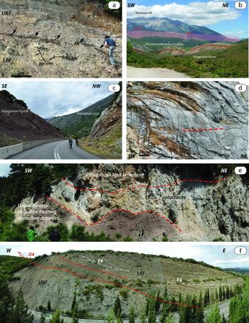
(a) UBF unconformably sedimented above the deformed LBF (Mount Iti area – 38° 47′ 5.4″ N; 22° 22′ 53.3″ E). (b) Panoramic view showing the overthrusting of the Mesoautochthonous Complex above the Pelagonian Flysch. In the background is evidenced the trace of the Distomon Fault (DSTF). (c) View towards the south within the core of the DSTF (38° 29′ 33.4″ N; 22° 41′ 47.9″ E). (d) Dextral strike-slip striae along the DSTF fault plane (38° 29′ 33.4″ N; 22° 41′ 47.9″ E). (e) Fault gouge between limestone of the Pelagonian Unit and Upper Jurassic ophiolite-bearing turbidites at the contact with the underlying Parnassus Flysch (Mount Iti area – 38° 43′ 53.6″ N; 22° 20′ 27.1″ E). (f) D4 tectonic contact between the LBFa (hangingwall) and UBFb (footwall) along the Levadhia–Arachova road-cut (38° 26′ 26.4″ N; 22° 48′ 44.5″ E).

5.c. Mesoscopic structural analysis
Structural and palaeostress studies concentrated on all units cropping out in the study area and on key outcrops of the Pelagonian Unit and Boeotian Flysch in the Mount Iti area. Mesoscopic and macroscopic superposed folding phases, some of which linked to thrusting, affected the Boeotian Flysch and Tertiary flysches, while the carbonate-dominated units only registered large-scale folding and brittle structures. The structural analysis combined with the stratigraphic records enabled us to distinguish a succession of six major deformational events, hereafter referred to as D1, D2, D3, D4, D4bt and D5, directly related to the evolution of the study area. Brittle deformation related to Triassic rifting processes and older deformations are beyond the scope of this paper.
5.c.1. D1 phase deformations
The oldest deformations recognized in the area are related to the Middle–Late Jurassic obduction of the Maliac–Vardar Ocean lithosphere onto the eastern Adria continental margin (i.e. the Pelagonian Zone). Mesoscopic deformation related to this phase was recognized in the Pelagonian and Boeotian units. Deformations are differentiated in time and space according to relative position with respect to the advancing ophiolite nappe shifting from a normal stress regime (D1a sub-stage) to a compressive stress regime (D1b sub-stage). This subdivision is clearly evident in the Pelagonian Unit while the Boeotian Unit, in this phase, registered only deformations of the D1a sub-stage.
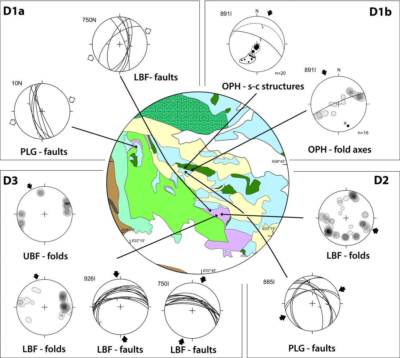
The D1a sub-stage is characterized by widespread syn-sedimentary deformations relative to different and subsequent episodes that affected the Upper Jurassic clastic deposits sedimented on top of the Pelagonian Platform and the LBF deposited onto the Boeotian carbonate sequence. Gravity-induced deformations such as slumping events, the formation of local wedge-shaped strata and repeated angular unconformities, as well as syn-sedimentary faults, are common in these deposits. Faults (Fig. 14, sites 10N and 750N) are characterized by cumulated episodes of faulting during sedimentation with variable throw ranging from some centimetres to half a metre (Fig. 15a). Syn-sedimentary faulting is particularly evident in the Upper Jurassic clastic sediments of the Pelagonian Unit up to the upper Tithonian–Hauterivian portions of the LBF (i.e. the LBFa and LBFb lithostratigraphic units). Stress inversion of the scarce fault-slip data collected in the LBF in the Levadhia area and in the ophiolite-bearing thin-bedded turbidites on top of the Pelagonian carbonates in the Mount Iti area results in an ENE–WSW direction of extension (Table 7; Fig. 14, sites 10N and 750N).
Distribution of mesostructural fault-slip data, fold axes and S-C structures relative to D1, D2 and D3 deformation phases. White arrows indicate direction of extension (σ3) and black arrows indicate direction of compression (σ1) calculated through inversion of fault-slip data. Black arrows of diagrams relative to folds and S-C structures are also indicative of the sense of tectonic movement. π-diagram on D1b fold axes in the OPH possibly indicates axis of successive deformation phases. All diagrams are equal-area lower hemisphere projections; density contours at 1% intervals. UBF – Upper Boeotian Flysch; LBF – Lower Boeotian Flysch; PLG – Pelagonian Unit; OPH – Ophiolitic Unit, mélange.

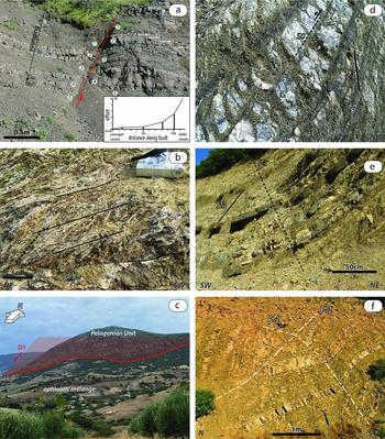
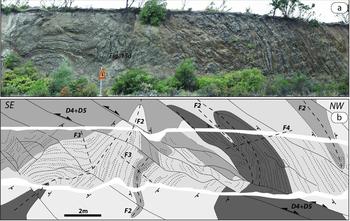
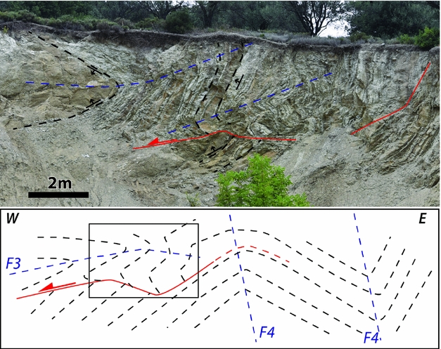
(a) Overturned syn-sedimentary fault showing cumulated episodes of faulting during sedimentation (ophiolite-bearing thin-bedded turbidites on top of the Pelagonian limestone; Iti area – 38° 44′ 56″ N; 22° 17′ 53″ E); the inset diagram shows cumulated offset on the fault. (b) S-C structures in the mélange sandwiched between the Pelagonian Unit and ophiolite nappe in the Kallidromon area (38° 41′ 08″ N; 22° 37′ 44″ E). (c) Overthrusting (D1 phase of deformation) of the Ophiolitic Unit above and the Pelagonian Unit. The tectonic contact was successively tilted by a large-scale anticline related to the D4 deformation phase to simulate a normal fault (Exarchos area, see Figs 8 and 11; 38° 35′ 53″ N; 22° 55′ 35″ E. (d) S3 disjunctive cleavage superimposed on the limb of F2 fold in the LBFb (Levadhia–Arachova road-cut – 38° 27′ 37″ N; 22° 45′ 46″ E). (e) S3 cleavage folded by an open F4 fold in LBFb (Levadhia–Arachova road-cut – 38° 27′ 37″ N; 22° 45′ 36″ E). (f) Interferences of F4bt open folds onto F4 tight fold near the back-thrust of the Parnassus units above the Parnassus Flysch (Levadhia area – 38° 25′ 57″ N; 22° 47′ 252″ E).

Since Barremian time, faulting in the LBF gave way to gravity-triggered deformations (slumps, disrupted layers, angular unconformities, erosional surfaces). The lack of any observable water-escape structures suggests that these deformations were induced by large-scale gravitational instability in the sedimentary basin rather than small-scale liquefaction of sediments due to increased pore-water pressure.
The most striking deformation related to the D1b sub-stage is the overthrusting of the ophiolite nappe with an underlying amphibolite sole and tectono-sedimentary mélange onto the Pelagonian Platform. In the studied area, the amphibolite sole always occurs as dismembered blocks embedded in the mélange matrix. Contacts of the Ophiolitic Unit onto the Pelagonian Unit were observed on the southern flank of the Kallidromon Mountains (Fig. 6). The footwall is characterized by highly sheared mélange showing pervasive scaly cleavage. A planar fabric is mainly represented by clay minerals enveloping lithic domains consisting of basalt, chert, serpentinite and sandstone. Well-developed kinematic indicators (S-C fabrics, asymmetric folds, asymmetric boudins) record a consistent top-to-the-SW sense of shear (Fig. 14, site 891I; Fig. 15b).
D1a syn-sedimentary faults were probably related to the lithospheric bending triggered in the Pelagonian Unit, first, and Boeotian Unit, later, by the obducting ophiolite nappe (Nirta et al. Reference Nirta, Moratti, Piccardi, Montanari, Catanzariti, Carras and Papini2015). Finally, D1b deformations marked the tectonic emplacement of the ophiolites and mélange onto the Pelagonian Platform (Fig. 15c) and the increasing gravity-triggered deformations in the Barremian–Aptian LBF (LBFc; Nirta et al. Reference Nirta, Moratti, Piccardi, Montanari, Catanzariti, Carras and Papini2015).
5.c.2. D2 phase deformations
The earliest folding event (F2) developed in the LBF is characterized by pervasive close to sub-isoclinal mesoscopic non-cylindrical folds with approximately similar geometry (class 2 of Ramsay, Reference Ramsay1967). Sandstone and limestone strata in the F2 fold limbs are often affected by boudinage with both symmetric and asymmetric geometries. Veins associated with the D2 deformational phase are oriented at a high angle to the bedding and filled with sparitic calcite. Despite the high strain ratio, which characterizes the F2 folds and the associated small-scale thrusts, these structures are rarely associated with cleavage. Fold axes and axial planes are strongly reoriented by successive folding and faulting, depicting a very dispersed pattern in the stereonet projections (D2 folds in Fig. 14). A tentative subtraction of the successive folding event (F3) seems to point to an original N–S-trending axes, whereas analysis of bedding-cleavage relationships, fold asymmetry and direction of younging point to a western vergence (Fig. 16).
F2 + F3 + F4 interference patterns in the LBF. Fold assemblage is dissected by D4 (reverse) and D5 (normal) faults (38° 27′ 37″ N; 22° 45′ 46″ E). Black arrows show younging direction.

D2 is possibly associated with renewed westward translation of the Ophiolitic Unit onto the Pelagonian Unit. This thrusting event in the Kallidromon zone cross-cuts the scaly cleavage acquired during the D1 phase of deformation and is associated with small-scale mesoscopic folds deforming the S1 foliation. Fault-slip data (Table 7, site 885I in Fig. 14) result in a NE–SW shortening direction, which is consistent with the major WNW–ESE-trending and N-dipping thrusts leading the ophiolites onto the Pelagonian Unit.
5.c.3. D3 phase deformations
D3 consists of a folding event (F3) well developed and exposed in the LBF and UBF. It is characterized by gentle to close folds with generally parallel geometry (class 1B of Ramsay, Reference Ramsay1967) in the LBF and close to tight folds with mostly similar geometry in the shaly-silty strata packages of the UBF. Axial plane foliation S3 is marked by disjunctive cleavage that is well developed only in the shaly layers of the turbiditic sequences (Fig. 15d, e). Isolated F3-fold hinge zones are common in the shale-dominated lithologies of the UBF.
F3 fold axes are scattered, as a result of the post-D3 deformations (Fig. 17). However, an original E–W trend of the F3 axes and the main N-dipping direction of the axial planes indicate a southward facing direction (F3 folds in the LBF and UBF of Fig. 14). Mostly N-dipping mesoscopic thrusts associated with folds were observed in the overturned limbs of tight folds (Fig. 17). Superimposed F2 + F3 interference results mostly in a type-3 pattern (Ramsay, Reference Ramsay1967).
F3 + F4 interference pattern in the LBF. The overturned limb of the main F3 fold and the associated thrust plane are re-folded by F4, and rotated to simulate a low-angle normal fault (38° 27′ 29″ N; 22° 53′ 26″ E).

Widespread E- to NE-dipping thrusts cross-cut D1 and D2 planar structures in the Ophiolitic Unit and Pelagonian Unit. However, it was not possible to clearly distinguish in the field D3 structures from brittle events associated with younger compressive phases (D4–D4bt).
5.c.4. D4 phase deformations
Mesoscopic and macroscopic structures related to this deformation phase are the most frequent and well developed in all the tectonic units.
F4 mesoscopic folds are mostly developed in the Pelagonian and Parnassus flysches and in both the LBF and UBF. Deformations in the Boeotian Flysch (LBF + UBF) are represented by gentle to tight isopach F4-folds associated with a disjunctive axial plane foliation S4 (Figs 15e, 16). In the Tertiary Pelagonian and Parnassus flysches, F4 folds are represented by close to tight structures with mostly similar geometry and with a weak continuous axial plane cleavage particularly evident only in the hinge zones. Axial plane attitude is generally upright to steeply inclined in the Boeotian Flysch and gently inclined to recumbent in the Tertiary flysches (Fig. 15f). Brittle shears commonly tear F4 hinge zones both in the Boeotian Flysch and in the Tertiary flysches.
Fold axes are gathered around a ENE–WSW trend in both the Tertiary flysches and Boeotian Flysch, plunging preferentially towards eastern sectors (F4 folds in the LBF, PAF and UBF of Fig. 18). Dispersion of F4 axes in the Tertiary flysches and the UBF appears to be caused by successive tectonic deformations, whereas most of the dispersion observed in the LBF seems to be also controlled, and locally forced, by the pre-existing structural fabric. Pole to axial plane processing on a π-diagram of F4 structures of the Pelagonian and Parnassus flysches points to an average axis trending N100. F4 axial planes steeply dip and gently dip towards northern sectors in the Boeotian Flysch and Tertiary flysches, respectively. The folds’ asymmetry and its relationships with bedding polarity, along with slip indicators of fold-related brittle shears clearly point to a SSW vergence direction.
Distribution of mesostructural fault-slip data and fold axes relative to D4 and D4bt deformation phases. White arrows indicate direction of extension (σ3) and black arrows indicate direction of compression (σ1) calculated through inversion of fault-slip data. Black arrows of diagrams relative to folds are also indicative of the sense of vergence. All diagrams are equal-area lower hemisphere projections; density contours at 1 % intervals. UBF – Upper Boeotian Flysch; LBF – Lower Boeotian Flysch; PLG – Pelagonian Unit, limestones; PLF – Pelagonian Flysch; PAR – Parnassus Unit, limestones; PAF – Parnassus Flysch; OPH – Ophiolitic Unit, mélange.

Asymmetric open megascopic F4 folds approximately E–W-trending and verging towards the south are well developed in the Mesoautochthonous carbonate sequences. These megastructures are bounded by thrust surfaces commonly isolating overturned fold limbs (Figs 11, 12, 13b). Mesoscopic fold interference patterns F2 + F4 and F3 + F4 observed in the LBF and UBF are mostly of type 3 (Ramsay, Reference Ramsay1967) (Figs 16, 17). Along the Levadhia–Amphissa road – 5 km east of Levadhia – D4 brittle reverse faults and open folds overprint F3 close folds, tilting and locally reactivating the D1 syn-sedimentary normal fault systems of the LBF (Nirta et al. Reference Nirta, Moratti, Piccardi, Montanari, Catanzariti, Carras and Papini2015) near a D4-thrust juxtaposing the LBFa onto the UBF (Fig. 13f).
Differences in the fold geometry among the Boeotian Flysch and Tertiary flysches are clearly linked to differentiation in structural levels, shallower in the Boeotian Flysch and deeper in the Tertiary flysches. In fact, the F4 folding event is associated with the westward overthrusting of the more internal tectonic units (Pelagonian, Boeotian and Ophiolitic units) above the Pelagonian Flysch, and the Parnassus Flysch in Tertiary times.
The overthrusting of the Pelagonian Unit and Ophiolitic Unit above the Boeotian and Parnassus units represents the major tectonic contact associated with this compressive phase. The superposition of the ophiolites, Pelagonian carbonates and slices of Boeotian Flysch above the Parnassus Flysch on Mount Iti and in the central Parnassus area (Amfiklia–Polydrosos area, Fig. 6) represent klippen related to this tectonic phase (Fig. 3, cross-section A–A′ in Fig. 8, Fig. 13e).
In the Kallidromon area and north of Exarchos village on the northern border of the Kopais plain, the Jurassic tectonic contact of the ophiolite nappe above the Pelagonian carbonates (D1 tectonic phase) is folded and cut by S-facing D4 structures (Figs 6, 8).
The Mesoautochthonous carbonate sequence is mostly detached from its substratum represented by the Pelagonian and Ophiolitic units, and overthrusts the Tertiary Pelagonian Flysch (Figs 12, 13b). During this tectonic phase, the progressive deformation enucleated N-dipping out-of-sequence thrusts in the Pelagonian Flysch and Boeotian Flysch mostly controlled by the structural buttress represented by the Parnassus Platform. The Triassic–Cretaceous Parnassus carbonates and Tertiary flysch are also deformed by N-dipping thrust structures.
Thrust structures are generally N-dipping, with angles varying from 10° to 50°; steeply dipping back-thrusts are less common. Major thrust structures are commonly accommodated by N–S-trending strike-slip faults, generally left-lateral.
The palaeostress analysis carried out on reverse and strike-slip faults related to the D4 phase indicates a NE–SW-trending shortening direction (Table 7; Fig. 18).
5.c.5. D4bt phase deformations
The D4bt deformations are well developed only at shallow structural levels in the Parnassus Flysch and in the Boeotian Unit carbonate sequence. They consist of thrust-related N-facing open to gentle F4bt folds, with SE–NW-trending axes and axial planes steeply dipping towards the southern sectors. These are associated with N-vergent thrusts (back-thrusts) leading both the Parnassus and Boeotian limestone units onto the Parnassus and Pelagonian flysches, respectively. Interferences of F4bt folds onto F4 folds have been found at various sites near the back-thrusts of the Parnassus and Boeotian units (Fig. 15f). Palaeostress analysis of thrusts and associated reverse faults indicates a NNE–SSW shortening direction (Table 7; Fig. 18).
5.c.6. D5 phase deformations
The D5 deformational event consists of both well-developed regional extensional faults and transtensive (D5T) faults that cross-cut all the previous structures. Inversion of fault-slip data points to NE–SW and NW–SE extension directions, accommodated by NNE-trending dextral strike-slip faults (Table 7; Fig. 19). They in part represent reactivated ancient normal structures possibly developed during the early rifting stage preceding obduction, successively affected by both compressional and extensional stress regimes (Table 7, sites 852D, 854SN, 932D and 963D in Fig. 19). The Distomon (Fig. 13c, d) and Aliki faults (DSTF and ALKF in Fig. 6) represent the main transverse structures affecting the studied area.
Schematic diagram illustrating areal distribution of mesostructural fault slip data and fold axes relative to D5 and D5T deformation phases. White arrows indicate direction of extension (σ3) and black arrows indicate direction of compression (σ1) calculated through inversion of fault slip data. All diagrams are equal-area lower hemisphere projections. UBF – Upper Boeotian Flysch; LBF – Lower Boeotian Flysch; PLG – Pelagonian Unit, limestones; PAR – Parnassus Unit, limestones; PAF – Parnassus Flysch.

5.c.7. Timing of deformation
The timing of deformation in the studied area is constrained by the age of syn-orogenic sedimentary units and by the Aptian regional unconformity underlying the Mesoautochthonous Complex and the UBF.
In the Pelagonian Unit the D1a sub-stage is dated as latest Jurassic as it is coeval with sedimentation of the ophiolite-bearing deposits topping the carbonate and pelagic succession (Figs 15a, 20). Syn-sedimentary extension-related deformations in the LBF were clearly observed only in the LBFa and in the lower part of the LBFb subunits allowing us to tentatively limit the age of the D1a sub-stage to the Tithonian–Valanginian time span.
Inferred ages of the Late Jurassic to Eocene deformation phases (D1 to D4) in Central Greece.

The D1b sub-stage deformations often follow but are partly coeval with the D1a deformations recorded in the more external portion of the Pelagonian Unit. The D1b deformations affected the Pelagonian Unit after sedimentation of radiolarite and ophiolite-bearing deposits and do not affect the LBF, allowing the attribution of a Kimmeridgian–?Valanginian age to the deformations. Valanginian is also the youngest age of the deformed platform carbonate units partly preserved above the ophiolite nappe (namely the Munella Platform above Mirdita ophiolites in Albania Fig. 1; Schlagintweit et al. Reference Schlagintweit, Gawlick, Missoni, Lein, Hosha, Sudar, Ercegovac and Grubic2006) and successively sealed by the mildly deformed Mesoautochthonous Complex. This suggests that obduction-related deformations lasted at least until Valanginian time.
The UBF and First Mesoautochthonous Cycle sealed the D2 deformations acquired by the LBF and Pelagonian Unit, respectively. In the Koumaritsi area a little-deformed succession of the UBF (oldest age: Albian; Nirta et al. Reference Nirta, Moratti, Piccardi, Montanari, Catanzariti, Carras and Papini2015) unconformably covers the LBFc subunit (youngest age: lower Aptian; Nirta et al. Reference Nirta, Moratti, Piccardi, Montanari, Catanzariti, Carras and Papini2015) that shows evidence of faulting and F2-related boudinage (Fig. 13a). The oldest age of the First Mesoautochthonous Cycle lying onto deformed ophiolites and the Pelagonian Unit is late Aptian in the more internal sector (Vermion–Vourinos area, Fig. 1; Photiades et al. Reference Photiades, Carras, Bortolotti, Fazzuoli and Principi2007) and Albian in the studied area. Considering the above data, it is possible to attribute an early to middle Aptian age to the D2 deformations.
The D3 deformations were clearly detected only in the LBF and UBF whereas it was not possible to ascertain their existence in the Mesoautochthonous Complex. On the other hand, they do not affect the Pelagonian and Parnassus flysches. As a consequence, the age and significance of this deformation phase remains so far ill-defined. Tentatively, it is possible to attribute a Santonian (youngest age of the UBF) to Paleocene age (oldest age of the Parnassus and Pelagonian flysches) to the D3 phase.
The D4 and localized D4bt deformations took place after the Pelagonian and Parnassus Flysch sedimentation (early Eocene) and were later sealed by the oldest post-orogenic sediments known in the area (Serravallian lacustrine deposits of the Thiva Basin; Mettos, Ioakim & Rondoyanni, Reference Mettos, Ioakim and Rondoyanni2000).
6. Proposed geodynamic model
The presented biostratigraphic, stratigraphic and structural data along with consolidated first-order geological constraints concerning the whole orogen converge in the reconstruction of the following tectonic evolution for the area:
6.a. From rifting to the passive margin stage
The rifting stage, accompanied by transitional to alkaline volcanism, occurred during early–Middle Triassic time and was widely documented in the Pelagonian succession (Baud et al. Reference Baud, Jenny, Papanikolaou, Sideris and Stampfli1991; Capedri et al. Reference Capedri, Toscani, Grandi, Venturelli, Papanikolaou and Skarpelis1997; A. De Bono, unpub. Ph.D. thesis, Univ. Lausanne, 1998). Furthermore, events of alkaline to transitional rift-related volcanism are also recorded in the Pindos stratigraphy (Pe-Piper, Reference Pe-Piper1982; Pe-Piper & Piper, Reference Pe-Piper and Piper1991).
In the Othrys Massif and in the Argolis Peninsula (Fig. 1) the transition from the Pelagonian Platform to the more distal eastern marginal series (West Maliac Margin Units) and up to the oceanic crust is well documented. The onset of oceanization in the Maliac–Vardar basin is testified to by the oldest radiolarites (Anisian) deposited on top of MOR basalts (Bortolotti et al. Reference Bortolotti, Chiari, Kodra, Marcucci, Marroni, Mustafa, Pandolfi, Prela, Principi and Saccani2006; Bortolotti et al. Reference Bortolotti, Chiari, Marroni, Pandolfi, Principi and Saccani2013; Ferrière et al. Reference Ferrière, Chanier, Baumgartner, Dumitrica, Caridroit, Bout-Roumazeilles, Graveleau, Danelian and Ventalon2015). By contrast, since Early Jurassic time the Pindos and Ionian geotectonic zones are interpreted as pelagic intracontinental basins separated by an intervening carbonate platform represented by the Gavrovo Unit (Fig. 1); the scattered outcrops testifying to the existence of a rifting stage in the Pindos Basin are then not corroborated by evidence of oceanization.
During the passive margin stage, east of the Pindos Basin, only the Pelagonian Zone could be clearly identified as an isopic zone while the Boeotian and Parnassus zones are not yet differentiated and shared with the Pelagonian Zone a similar stratigraphy dominated by neritic carbonates of from Late Triassic to early Middle Jurassic age (Fig. 4).
In the proposed model, the Late Triassic geotectonic setting of the transition from the Adria continental margin to the Maliac–Vardar Ocean can be summarized as in Figure 21a.
Proposed geodynamic model and tectonic evolution for the obduction and continental collision in the Hellenic belt. See text for discussion.

6.b. Obduction – D1 tectonic phase
Intraoceanic subduction in the Maliac–Vardar Ocean is testified to by the occurrence of ophiolitic sequences developed in a supra-subduction environment (Beccaluva et al. Reference Beccaluva, Coltorti, Saccani and Siena2005; Saccani et al. Reference Saccani, Photiades, Santato and Zeda2008b ; Bortolotti et al. Reference Bortolotti, Chiari, Marroni, Pandolfi, Principi and Saccani2013) and by a subduction-related continental magmatic arc and back-arc basin towards the European margin (i.e. the Paikon arc and Guevgueli back-arc basin; Mercier, Reference Mercier1966; Ferrière & Stais, Reference Ferrière and Stais1995; Brown & Robertson, Reference Brown and Robertson2003, Reference Brown and Robertson2004; Saccani et al. Reference Saccani, Bortolotti, Marroni, Pandolfi, Photiades and Principi2008a ; Bortolotti et al. Reference Bortolotti, Chiari, Marroni, Pandolfi, Principi and Saccani2013) developed since early Middle Jurassic time (Fig. 22a). These magmatic events imply the existence of an E-dipping subducting plane since Early Jurassic time (Bortolotti et al. Reference Bortolotti, Marroni, Pandolfi and Principi2005).
Schematic reconstruction of the evolution of subduction-related magmatism accompanying the closure of the Maliac–Vardar Ocean from Middle Jurassic time until Late Cretaceous post-collisional collapse. The Middle–Late Jurassic step is redrawn after figure 10 in Bortolotti et al. (Reference Bortolotti, Chiari, Marroni, Pandolfi, Principi and Saccani2013). Not to scale.

During Middle Jurassic time, as a consequence of the continuing convergence between Adria and Europe, tectonically decoupled oceanic lithosphere started thrusting westwards (Bébien et al. Reference Bébien, Ohnenstetter, Ohnenstetter and Vergély1980; Spray & Roddick, Reference Spray and Roddick1980). This event led to metamorphism at the sole of the overriding slab and mélange formation after off-scraping of the facing oceanic sediments and erosion of the advancing slab. At the Middle–Late Jurassic transition, the overriding slab approached the eastern margin of the Adria continental margin (i.e. the Pelagonian Zone). In late Middle Jurassic time, the advancing ophiolite nappe caused a rapid drowning of the distal continental margin (i.e. West Maliac Margin Units) that shifted from carbonate deposition to deep-sea siliceous deposition and then to ophiolite-bearing mass flow deposits. At the same time, to the west the continental margin experienced emersion episodes in the western Pelagonian Zone and in the Parnassus Zone (b1 bauxite horizon) (Figs 4, 21b). Emersion is correlated with the lithospheric forebulge induced by the load of the ophiolite nappe to the east (Nirta et al. Reference Nirta, Moratti, Piccardi, Montanari, Catanzariti, Carras and Papini2015). The bending was accommodated by drowning of a large portion of the former Pelagonian Platform and development of the Boeotian Basin (Fig. 21b). Differentiation of the Parnassus and Pelagonian zones with interposition of the Boeotian Basin was a diachronous event. In fact, while some platform portions rapidly drowned to form the future Boeotian Basin (Aliki and Makariotissa sections; Danelian & Robertson, Reference Danelian and Robertson1998), some other portions necessarily represent a continuous shallow-water environment to allow the migration of the allochthonous b1 bauxites from the ophiolites to the east throughout the western Pelagonian Platform and up to the future Parnassus Zone. An obduction-related extensional regime is registered by the syn-sedimentary faulting in the mass flow deposits on top of the Jurassic carbonates of the Pelagonian Unit and in the LBF throughout latest Jurassic time (D1a sub-stage; Fig. 21b). Final overthrusting of the ophiolites and associated mélange progressively shifted into a compressional tectonic regime in the Pelagonian Platform (D1b sub-stage; Fig. 21b). The time–space distribution of the ophiolite detritus supplied by the obducting units in the facing continental margin and top-to-the-SW kinematic indicators within the tectonic foliation S1 clearly point to an E-towards-W translation of the obducted units. This sedimentation versus obduction trend is clearly recognizable throughout Late Jurassic time and culminated with the beginning of sedimentation of the LBF in the Boeotian Basin. At this time, a new emersion episode was recognized in the Parnassus Platform (b2 horizon), which could possibly reflect a tectonically forced regression, induced during the climaxing phase of obduction (Fig. 21c). Obduction could be traced up to Valanginian time, as suggested by the age of the youngest ophiolite-derived clastic deposits on the top of the Pelagonian Platform and the youngest syn-obduction carbonate platform set on the top of the ophiolite nappe (i.e. the Munella Platform; Schlagintweit et al. Reference Schlagintweit, Gawlick, Missoni, Lein, Hosha, Sudar, Ercegovac and Grubic2006).
The youngest evidence of oceanic crust in the Maliac–Vardar Ocean is of latest Jurassic age (Bortolotti et al. Reference Bortolotti, Chiari, Marroni, Pandolfi, Principi and Saccani2013 and quoted references). Similarly, back-arc magmatism between the Paikon arc and the Eurasian margin (Guevgueli back-arc basin), induced by the E-directed subducting slab of the Maliac–Vardar Ocean (Saccani et al. Reference Saccani, Bortolotti, Marroni, Pandolfi, Photiades and Principi2008a) since Middle Jurassic time, continued until Late Jurassic time (Danelian, Robertson & Dimitriadis, Reference Danelian, Robertson and Dimitriadis1996; Kukoč et al. Reference Kukoč, Goričan, Kosir, Belak, Halamic and Hrvatović2012) and was also associated with the coeval emplacement of calc-alkaline granitoids both in the back-arc oceanic crust and in the nearby Eurasian continental margin (e.g. Fanos granite; Anders et al. Reference Anders, Reischmann, Poller and Kostopoulos2005; Šarić et al. Reference Šarić, Cvetkoviç, Romer, Christofides and Koroneos2009). Moreover, arc-related calc-alkaline granitoids, now found as orthogneisses in the Rhodope Massif, are reported to intrude the Eurasian margin further east until Late Jurassic – Early Cretaceous times (Turpaud & Reischmann, Reference Turpaud and Reischmann2010) (‘Rhodopian intrusions’ in Fig. 22b). Therefore, we assume that E-dipping subduction of the Maliac–Vardar Ocean continued throughout Early Cretaceous time. However, a high convergence rate between Adria and Europe during this period (Rosenbaum, Lister & Duboz, Reference Rosenbaum, Lister and Duboz2002; Bertrand, Guillou-Frottier & Loiselet, Reference Bertrand, Guillou-Frottier and Loiselet2014) could have induced upper plate compression that prevented upward migration of magmas necessary to trigger widespread volcanic activity and, at the same time, could have facilitated sequestration of melts at deep to moderate crustal depths.
6.c. Continental collision: D2 tectonic phase
Ophiolite-derived mass flow gliding events progressively increased in the upper portion of the LBF of Barremian–Aptian age (LBFc). The sedimentation in the Boeotian trough was stopped by an intense tectonic event that produced the most pervasive deformations in the LBF. The beginning of sedimentation of the UBF of Albian age sealed D2 tectonic deformations in the underlying LBF (Nirta et al. Reference Nirta, Moratti, Piccardi, Montanari, Catanzariti, Carras and Papini2015) allowing the attribution of an Aptian–Albian age to this tectonic event. In the same time span compressional deformation likely controlled the Parnassus Platform emersion soon after the deposition of allochthonous bauxitic laterites (b3 horizon) derived from degradation of penecontemporaneous weathering crusts developed on the more internal units (i.e. Pelagonian and Ophiolitic obducted units) (Fig. 21d). The stratigraphic gap corresponding to the third bauxite horizon (b3) is the longest one since it extended from part of the Aptian to at least the lower Turonian (> 20 Ma; Combes et al. Reference Combes, Fourcade, Masse and Philip1981; Carras & Tselepidis, Reference Carras, Tselepidis, Solakius and Kati2001). The stable and relatively high sea level record from Valanginian until Late Cretaceous times (Haq, Reference Haq2014) allows ascribing the b3 emersion episode to the far-field effects of compressional tectonics.
This prominent Aptian–Albian tectonic phase was also recorded by upper-greenschist to blueschist metamorphic events in the inner Pelagonian Zone (Barton, Reference Barton1976; Yarwood & Dixon, Reference Yarwood and Dixon1977; Schermer, Lux & Burchfiel, Reference Schermer, Lux and Burchfiel1990; Lips, White & Wijbrans, Reference Lips, White and Wijbrans1998) (Fig. 4), and by nappe stacking and high-pressure conditions in the Rhodope Massif (130–115 Ma; Burg, Reference Burg, Skourtsos and Lister2012). Furthermore, the ophiolitic units of the EOB, mostly represented by island arc and back-arc basin ophiolites (Ferrière & Stais Reference Ferrière and Stais1995; Saccani et al. Reference Saccani, Bortolotti, Marroni, Pandolfi, Photiades and Principi2008a ; Bonev et al. Reference Bonev, Marchev, Moritz and Collings2015), emplaced eastwards above the Eurasian margin units previously affected by Late Jurassic high-pressure metamorphism (Bonev et al. Reference Bonev, Marchev, Moritz and Collings2015 and quoted references). This emplacement was postdated by unconformable sedimentation of Lower Cretaceous carbonates in the Circum-Rhodope Belt (i.e. westernmost part of the Rhodope Massif; Mercier Reference Mercier1968; Stais & Ferrière, Reference Stais and Ferrière1994; Ivanova, Bonev & Chatalov, Reference Ivanova, Bonev and Chatalov2015). This testifies that at the Late Jurassic – Early Cretaceous transition the magmatic arc and back-arc oceanic basin located to the west of the Eurasian margin (i.e. the Guevgueli back-arc ophiolites and the Paikon arc ophiolites) had already ceased their magmatic activity and were emplaced above deformed and metamorphosed units of the Eurasian margin (Bonev et al. Reference Bonev, Marchev, Moritz and Collings2015; Saccani et al. Reference Saccani, Chiari, Bortolotti, Photiades and Principi2015; Ferrière, Baumgartner & Chanier, Reference Ferrière, Baumgartner and Chanier2016) (Figs 21c, 22b).
Finally, anatectic melts of late Aptian age (Schenker et al. Reference Schenker, Burg, Kostopoulos, Moulas, Larionov and Von Quadt2014) were recognized in the eastern Pelagonian rim.
All these events, along with the lack of evidence of ophiolites younger than Late Jurassic in the Albanian–Hellenic sector of the orogen, allow interpreting the D2 deformation phase as a manifestation of the final continental collision of the Pelagonian Margin (Adria Plate) with the Rhodope Massif (European Plate). In this interpretation the LBF sedimented in a temporal window placed between the ongoing obduction and continental collision (Fig. 21c).
Structural analysis of D2 structures points to a westward tectonic transport. The observable tectonic relationships between the LBF and the inner tectonic units allow explaining the D2 deformation as being the result of the activation of a sole thrust at the base of the Pelagonian Platform and rejuvenated westward tectonic translation of the overlying ophiolitic thrust sheets.
However, the occurrence of Late Cretaceous ophiolites in the Kozara Mountains (northern Bosnia and Herzegovina; Karamata et al. Reference Karamata, Olujić, Protić, Milovanović, Vujnović, Popević, Memović, Radovanović, Resimić-Sarić, Karamata and Janković2000; Ustaszewski et al. Reference Ustaszewski, Schmid, Lugovic, Schuster, Schaltegger, Bernoulli, Hottinger, Kounov, Fügenschuh and Schefer2009, Reference Ustaszewski, Kounov, Schmid, Schaltegger, Krenn, Frank and Fügenschuh2010) testifies that the collision in the northern sectors of the belt occurred in latest Cretaceous – Paleocene times (Schmid et al. Reference Schmid, Bernoulli, Fügenschuh, Matenco, Schefer, Schuster, Tischler and Ustaszewski2008).
Two main hypotheses exist concerning the timing of collision in the Hellenic–Dinaric chain and final closure of the Maliac–Vardar Ocean: latest Cretaceous–Tertiary throughout the whole orogen (Robertson & Dixon, Reference Robertson, Dixon, Dixon and Robertson1984; Robertson et al. Reference Robertson, Clift, Degnan and Jones1991, Reference Robertson, Trivić, Đerić and Bucur2013; Pamic, Reference Pamic2002; Schmid et al. Reference Schmid, Bernoulli, Fügenschuh, Matenco, Schefer, Schuster, Tischler and Ustaszewski2008) or latest Jurassic – Early Cretaceous (Papanikolaou, Reference Papanikolaou1997, Reference Papanikolaou2009, Reference Papanikolaou2013; Meinhold et al. Reference Meinhold, Kostopoulos, Reischmann, Frei and BouDagher-Fadel2009; Bortolotti et al. Reference Bortolotti, Chiari, Marroni, Pandolfi, Principi and Saccani2013; Schenker et al. Reference Schenker, Burg, Kostopoulos, Moulas, Larionov and Von Quadt2014), at least in the Albanian–Hellenic sector. To date, both hypotheses could be considered valid; however, the evidence so far collected in Albania and Greece and the differences between the southern and northern sectors of the belt (see discussion in Saccani et al. Reference Saccani, Chiari, Bortolotti, Photiades and Principi2015) lead us to prefer a diachronous closure model explaining earlier collision in the south and later in the northern sectors.
This diachronous closure could alternatively be explained as the consequence of variable widths of different oceanic sectors, possibly separated by lithospheric lineaments (e.g. the Scutari–Pec fault zone, Fig. 1; Dercourt, Reference Dercourt1967; Kissel, Speranza & Milicevic, Reference Kissel, Speranza and Milicevic1995), or due to oblique subduction (Smith & Spray, Reference Smith, Spray, Dixon and Robertson1984).
6.d. The Late Cretaceous post-collisional tectonics
After the climax of the collisional event in the Boeotia region, the sedimentation resumed with the flysch deposition in the Boeotian Basin (i.e. UBF) and the neritic carbonates of the Mesoautochthonous Complex above the ophiolitic thrust sheets and Pelagonian Unit (Fig. 21d). Both the UBF and the first cycle of Mesoautochthonous sequences are underlined by unconformable contacts marked by lateritic crusts, coarse-grained mass flow deposits and erosional surfaces. The high proportion of ophiolite debris in the UBF along with common calcareous mass flows and lateritic debris (Nirta et al. Reference Nirta, Moratti, Piccardi, Montanari, Catanzariti, Carras and Papini2015) implies still active tectonics along the eastern edge of the Boeotian Basin that triggered drowning of ephemeral platforms, emersion episodes and catastrophic collapses along the shelf break. The sedimentary environment of the UBF could be that of a foreland basin, while the Mesoautochthonous Complex contemporaneously sedimented in the subsiding hinterland sectors after the tectonic climax related to collision (D2 phase).
The correlation of the UBF with the coeval siliciclastic turbidite deposits of the Pindos Zone (Premier Flysch du Pinde; Aubouin, Reference Aubouin1957; Fleury, Reference Fleury1975; Maillot, Reference Maillot1979; Wagreich et al. Reference Wagreich, Pavlopoulos, Faupl and Migiros1996; Neumann, Reference Neumann2001) is also proposed. A similar composition and palaeocurrent data of the UBF and ‘Premier Flysch du Pinde’ (Neumann, Reference Neumann2001) point to a common provenance from the internal (eastern) zones that produced turbidite currents then deposited in the basinal areas of the Boeotian Zone and those bordering the eastern Pindos Basin.
There is evidence of an older deformation phase preceding the ubiquitous Tertiary events that gave rise to the older deformations observed in the UBF and cross-cuts D2 structures of the LBF (D3 deformation phase).
This deformation phase is poorly constrained because of the paucity of explicative outcrops in the UBF and resistance in developing mesoscale deformations in the Mesoautochthonous Complex. However, we tentatively attribute to this deformation a Late Cretaceous age as no D3 deformations were recognized in the Tertiary flysches.
D3 deformations, showing westward vergence, could be linked with a renewed westward translation of the Internal Hellenid units related to the ongoing Africa–Eurasia convergence. Progressive westward thrusting was coupled with syn-orogenic exhumation of portions of the eastern Pelagonian Zone as testified to by available geochronological data (T. Most, unpub. Ph.D. thesis, Eberhardt-Karls-Universität Tubingen, 2003; Schenker, Fellin & Burg, Reference Schenker, Fellin and Burg2015). Exhumation of metamorphic terrains of the Pelagonian Zone was linked with an uplifted dome, possibly through a regional antiformal structure (Kilias et al. Reference Kilias, Frisch, Avgerinas, Dunkl, Falalakis and Gawlick2010; Schenker et al. Reference Schenker, Burg, Kostopoulos, Moulas, Larionov and Von Quadt2014), that was successively eroded and supplied both continental-derived metamorphic and ophiolitic debris to the adjacent Mesoautochthonous basins (T. Most, unpub. Ph.D. thesis, Eberhardt-Karls-Universität Tubingen, 2003; Photiades et al. Reference Photiades, Carras, Bortolotti, Fazzuoli and Principi2007; Schenker et al. Reference Schenker, Burg, Kostopoulos, Moulas, Larionov and Von Quadt2014) (Fig. 21d).
Sedimentation of the Mesoautochthonous Complex was synchronous with the development of an arc-related calc-alkaline magmatism in the upper plate, the Eastern Srednogorie and Panagyurishte area (Bulgaria). The northward continuation of these magmatic districts as far as Romania concurs to form the Apuseni–Banat–Timok–Srednogorie magmatic–metallogenic belt (ABTS; Jankovic, Reference Jankovic1997; von Quadt et al. Reference von Quadt, Moritz, Peytcheva and Heinrich2005; Zimmerman et al. Reference Zimmerman, Stein, Hannah, Koželj, Bogdanov and Berza2008; Richards, Reference Richards2015).
A wide debate exists on the mechanism guiding the magma generation in the ABTS and its development with respect to the onset of continental collision, with different models reflecting divergences in the palaeogeographic reconstructions. Summarizing, the proposed models include those favouring pre-collisional subduction-related magmatism, eventually accompanied by slab rollback (Lips, Reference Lips, Blundell, Neubauer and von Quadt2002; von Quadt et al. Reference von Quadt, Moritz, Peytcheva and Heinrich2005; Chambefort & Moritz Reference Chambefort and Moritz2006; Zimmerman et al. Reference Zimmerman, Stein, Hannah, Koželj, Bogdanov and Berza2008; Gallhofer et al. Reference Gallhofer, Quadt, Peytcheva, Schmid and Heinrich2015) or syn-collisional slab tearing/slab break-off (Neubauer, Reference Neubauer, Blundell, Neubauer and von Quadt2002) and post-collisional orogenic collapse (Berza, Constantinescu & Vlad, Reference Berza, Constantinescu and Vlad1998; Bojar, Neubauer & Fritz, Reference Bojar, Neubauer and Fritz1998; Willingshofer, Neubauer & Cloetingh, Reference Willingshofer, Neubauer and Cloetingh1999; Iancu et al. Reference Iancu, Berza, Seghedi, Gheuca and Hann2005). In particular, some authors (Lips, Reference Lips, Blundell, Neubauer and von Quadt2002; Gallhofer et al. Reference Gallhofer, Quadt, Peytcheva, Schmid and Heinrich2015) considered the continuous subduction of oceanic crust and slab steepening/rollback as the only mechanism that guided the evolution of the whole ABTS during Late Cretaceous time. They assumed that a new oceanic subduction started in the Maliac–Vardar Ocean in Albian time, after the Early Cretaceous tectonic phase (D2). In this hypothesis, melt production started as soon as the subducting slab reached the partial melting zone and continued throughout Late Cretaceous time fuelled by a continuous subduction until continental collision in latest Cretaceous time (Gallhofer et al. Reference Gallhofer, Quadt, Peytcheva, Schmid and Heinrich2015). On the other hand, recent research along the Alpine–Himalayan belt has revealed that many magmatic deposits previously assumed to be subduction related are in fact syn- or post-collisional (Shafiei, Haschke & Shahabpour, Reference Shafiei, Haschke and Shahabpour2009; Moritz et al. Reference Moritz, Márton, Ortelli, Marchev, Voudouris, Bonev, Spikings and Cosca2010; Imer, Richards & Creaser, Reference Imer, Richards and Creaser2013) and sometimes occur long (30–40 Ma) after the end of oceanic lithosphere subduction (Hou et al. Reference Hou, Yang, Qu, Meng, Li, Beaudoin, Rui, Gao and Zaw2009, Reference Hou, Zhang, Pan and Yang2011).
In our interpretation, the evolution of the ABTS possibly follows the diachronism in the collision as testified to by the different ages of the older magmatic events (and beginning of extension) varying from Cenomanian–Turonian in the south (Eastern Srednogorie and Panagyurishte area, Bulgaria) up to Santonian–Campanian (Banat and Apuseni regions, Romania) in the north (see data compilation in Gallhofer et al. Reference Gallhofer, Quadt, Peytcheva, Schmid and Heinrich2015). We interpret the Mesoautochthonous Complex and the Eastern Srednogorie and Panagyurishte magmatic arcs (roughly corresponding to the Hellenic and Albanian sectors of the belt) as connected to regional extension in the upper plate following an initial slab steepening started soon after the continental collision (i.e. Albian), followed by warming of the stalled slab and its successive break-off (Wortel & Spakman, Reference Wortel and Spakman2000; Neubauer, Reference Neubauer, Blundell, Neubauer and von Quadt2002) and widespread orogenic collapse from late Cenomanian–Turonian times (Fig. 22c,d). Numerical modelling shows that the delay in time between the onset of collision and final slab break-off can be 20 Ma (Duretz, Gerya & May, Reference Duretz, Gerya and May2011; van Hunen & Allen, Reference van Hunen and Allen2011) in the case of old, and therefore cold and strong, subducting slabs. At the time of collision onset (c. 115 Ma) the subducted Maliac–Vardar oceanic lithosphere was represented by old and strong Triassic to Middle Jurassic crust, thus the final break-off could be postulated at c. 95 Ma (i.e. late Cenomanian–Turonian), which corresponds with the age of the comagmatic sediments in the Eastern Srednogorie area (Nachev & Dimitrova, Reference Nachev and Dimitrova1995). The formation of the arc magmatism was facilitated by reduced plate convergence starting from early Late Cretaceous time (Rosenbaum, Lister & Duboz, Reference Rosenbaum, Lister and Duboz2002; Bertrand, Guillou-Frottier & Loiselet, Reference Bertrand, Guillou-Frottier and Loiselet2014). Furthermore, we assume that after the Aptian–Albian continental collision, a slow subduction continued with the involvement of the Pelagonian thinned crust (Stampfli, Marcoux & Baud, Reference Stampfli, Marcoux and Baud1991; Robertson et al. Reference Robertson, Clift, Degnan and Jones1991). Collision and subduction of the portions of thinned continental crust concur in reducing the lateral force acting on the slab causing a rapid slab steepening enhanced by its vertical gravitational force (Fig. 22c). This mechanism may have favoured orogenic collapse in the upper plate and easier ascent of fertile magmas to the upper crust (Berza, Constantinescu & Vlad, Reference Berza, Constantinescu and Vlad1998).
6.e. Tertiary crustal shortening and thickening: D4 and D4bt deformation phases
During late Paleocene time, ubiquitous shaly pelagic sediments (pre-flysch lithofacies) unconformably covered the tectonic stack levelling the sea floor morphology (Fig. 21e). The following turbiditic sedimentation onset in early Eocene time was almost synchronous in the different geotectonic zones. On the other hand, terminal ages are diachronous showing a younging trend towards the western sectors. In the studied area, the Pelagonian Flysch lasted until early Eocene time, the Parnassus Flysch until early–middle Eocene time and the Pindos Flysch until late Eocene time. This trend reflects the W-verging tectonic transfer related to late-stage thrusting that remobilized the previously formed tectonic stack above the Parnassus Platform (D4 deformation phase). The age of overthrusting of the internal tectonic units above the Parnassus Platform is constrained by the terminal age of the Parnassus Flysch (early–middle Eocene). Moreover, during Lutetian time, ophiolite slide blocks and debris flow deposits glided in the Pindos Flysch in the Etolia region just in front of the Vardoussia slope (C. Beck, unpub. Ph.D. thesis, Univ. Science and Technology, Lille, 1975; Beck, Reference Beck1980; Figs 2, 21f). We locate the provenance area of these ophiolite-bearing mass flows in the Iti ocean-derived klippe located on top of the Parnassus Unit, thus dating the age of overthrusting of the Internal Hellenid units above the Parnassus Platform to middle Eocene (Lutetian) time.
Extensive nappe stacking and continental crust thickening characterized the Tertiary compressive phase. Protracted convergence between Adria and Eurasia during the D4 tectonic phase led to the final accretion of the Pelagonian Unit and its decoupling from the subducting Adriatic slab (Jolivet & Brun, Reference Jolivet and Brun2010) and consequent shifting of the compressive front to the more external southwestern portions of the belt. As a result, the Pindos and Gavrovo zones were progressively involved in the fold and thrust belt and metamorphosed to form the Cycladic Blueschist Complex since middle Eocene time (Jolivet & Brun, Reference Jolivet and Brun2010 and references therein) (Fig. 21f).
The last compressional event recognized in the study area (D4bt) is localized on the northeastern rim of the Parnassus Platform that acted as a tectonic buttress locally conditioning the tectonic migration. Along the northern border of the Helicon mountain range, the Parnassus Cretaceous limestones thrust northwards folding and cross-cutting the previous D4 structures. Furthermore, the Boeotian Zone limestone sequence was squeezed between the Pelagonian and Parnassus units guiding it to thrust northwards above the previously stacked units including the Eocene Pelagonian Flysch (Figs 6, 8).
6.f. Aegean extensional regime: D5 deformation phase
The previously stacked units were then dissected by both high- and low-angle faults under an extensional stress field with a horizontal ENE-oriented minor principal (σ3) stress axis (Fig. 19). Extension inverted some D4 thrusts as low-angle fault zones (see Figs 16, 21f) or as regional detachments (Papanikolaou, Gouliotis & Triantaphyllou, Reference Papanikolaou, Gouliotis, Triantaphyllou, Hinsbergen, Edwards and Govers2009). Clear evidence within the studied area is represented by the tectonic contacts at the base of the internal units overthrust above the northern flank of the Parnassus Platform (Kranis & Papanikolaou, Reference Kranis and Papanikolaou2001; Fig. 6).
The extensional regime, whose main regional effect is the opening of the Aegean Sea and exhumation of the Cycladic Blueschist Complex, started in northern Greece in late Eocene time (Gautier et al. Reference Gautier, Brun, Moriceau, Sokoutis, Martinod and Jolivet1999; Lips, White & Wijbrans, Reference Lips, White and Wijbrans2000; Jolivet et al. Reference Jolivet, Faccenna, Goffé, Burov and Agard2003; Jolivet & Brun, Reference Jolivet and Brun2010) and progressively moved southwards while accretion continued at the subduction zone. Aegean extension is commonly considered a consequence of the slab retreat of Adria with respect to Eurasia (Le Pichon & Angelier, Reference Le Pichon and Angelier1979; Meulenkamp et al. Reference Meulenkamp, Wortel, van Wamel, Spakman and Hoogerduyn Strating1988; Jolivet et al. Reference Jolivet, Faccenna, Huet, Labrousse, Le Pourhiet, Lacombe, Lecomte, Burov, Denèle, Brun, Philippon, Paul, Salaün, Karabulut, Piromallo, Monié, Gueydan, Okay, Oberhänsli, Pourteau, Augier, Gadenne and Driussi2013).
In the studied area, transition from a compressional to extensional regime was accompanied by clockwise block rotation accommodated by NNE-trending dextral transversal faults developed at the regional scale (e.g. Distomon (DSTF) and Aliki (ALKF) fault zones; see Fig. 6). Block rotations emphasized the northward back-thrust of the Boeotian Unit with the activation of the ATRF zone (Fig. 6) with left-lateral movement. Clockwise block rotations were possibly accentuated since c. 5 Ma by the interaction of the right-lateral North Anatolian Fault system (Armijo et al. Reference Armijo, Meyer, King, Rigo and Papanastassiou1996, Reference Armijo, Meyer, Hubert and Barka1999) that also enhanced extension in the North Aegean Sea, Euboea–Sperchios Graben and Corinth Basin (Goldsworthy, Jackson & Haines, Reference Goldsworthy, Jackson and Haines2002).
7. Final remarks
The Hellenic orogen developed (and is still evolving) as a result of the African–European convergence since Middle Jurassic time. Superimposed obduction and collision-related compressive tectonic phases followed by extension resulted in a complex arrangement of the ophiolitic outcrops along the belt, leading some authors to identify a multiplicity of ‘ophiolitic belts’ eventually interpreted as remnants of just as many oceanic branches or basins. The biostratigraphic, stratigraphic and structural data newly collected in the Boeotia region, along with consolidated first-order geological constraints concerning the whole orogen, were here used to reconstruct the tectonic evolution of this area, and to propose a ‘single ocean’ tectonic model spanning from Middle Jurassic up to Tertiary times. In the studied transect it is possible to consider two extra main geological constraints: the existence of a pelagic basin since Middle Jurassic time west of the Pelagonian Platform (i.e. the Boeotian Zone), and a persistent carbonate platform throughout the Mesozoic located further west, the Parnassus Zone.
In the Hellenic orogen obduction followed an earlier event of intraoceanic thrusting of Middle Jurassic age (174–160 Ma; Roddick, Cameron & Smith, Reference Roddick, Cameron and Smith1979; Spray & Roddick, Reference Spray and Roddick1980; Dimo-Lahitte, Monié & Vergély, Reference Dimo-Lahitte, Monié and Vergély2001) and culminated with ophiolite emplacement onto the Adria continental margin during Early Cretaceous time. The assemblage of geochemical signatures of the ophiolites of the WOB and EOB is substantially identical, and also similar are the isotopic ages of the metamorphic soles at their base. A differential origin of the WOB and EOB in two (or more) oceanic basins that emplaced contemporaneously onto continental margin(s) would thus contrast with the existence of a persisting carbonate platform throughout Cretaceous time in between (i.e. Parnassus), and with structural data relative to the Jurassic and Cretaceous tectonic phases pointing to a constant westward tectonic transfer.
In the Hellenic–Albanian sector of the belt the youngest ophiolites are of latest Jurassic age. This datum along with the documentation of a severe Early Cretaceous tectonic phase accompanied by erosion, metamorphism, ophiolite emplacement and nappe stacking both on the easternmost Adria margin units (i.e. the eastern Pelagonian Unit) and westernmost Eurasian margin units (Circum-Rhodope and Rhodope units; Burg, Reference Burg, Skourtsos and Lister2012; Bonev et al. Reference Bonev, Marchev, Moritz and Collings2015; Ivanova, Bonev & Chatalov, Reference Ivanova, Bonev and Chatalov2015) contrasts with a persisting oceanic basin throughout Cretaceous time.
These general considerations along with the reconstruction of the tectono-stratigraphic evolution of the studied units allow proposing the Aptian–Albian boundary as the age of collision between Adria and Eurasia, about 25 Ma after the end of obduction (Valanginian).
Acknowledgements
This research was supported by the Italian Ministry of Education, University and Research – PRIN 2010–2011 project: ‘Birth and death of oceanic basins: geodynamic processes from rifting to continental collision in the Mediterranean and circum-Mediterranean orogens’, grant no. 2011AZR98L_005. Many thanks go to Michele Marroni and Emilio Saccani for helpful observations, enlightening discussions and fruitful suggestions. We also wish to thank Špela Goričan for her useful suggestions. We are indebted to Jacky Ferrière and to an anonymous reviewer for their constructive reviews and useful comments that greatly improved the manuscript.