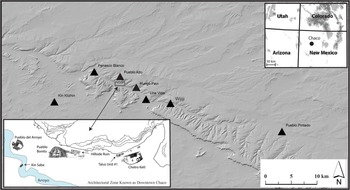
The emergence of Chaco Canyon in northwest New Mexico as the center of an incipient complex society between about AD 850 and 1200 (the Bonito Phase) involved enormous amounts of labor and capital input in the construction of massive, freestanding, multistory masonry communal buildings with hundreds of rooms known to archaeologists as “great houses” (Figure 1). Despite the rapid development of novel architectural forms and construction techniques during the Bonito Phase, the only documented technological innovation associated with great house construction in Chaco Canyon appears to have been diversion canals at Pueblo Bonito, which protected the great house from flooding and may have impounded runoff near construction sites (Wills Reference Wills2017; Wills, et al. Reference Wills, Williams, Murphy, Przystupa and Dorshow2021). Otherwise, the production processes involving the erection of structures were fundamentally about knowledge-based communication.
Major Chaco Canyon great houses in the San Juan Basin of northwest New Mexico, also known as the “Chaco Core.” The clustering of large eleventh-century AD great houses in the lower reach of the canyon is referred to colloquially as “Downtown Chaco.”

As in historical and modern building construction, great house production processes included the initial conceptualization of the final building form, acquisition of building materials, mobilization and support of labor, management of construction work (which involved engineering problems), resolution of any conflicts among workers, adjustments to unexpected delays or shortages, and approval of the results (Fitchen Reference Fitchen1986). Structural failures or flawed assembly were likely problems given the load stresses resulting from adding multiple stories to unbuttressed stone-and-mortar walls. All aspects of production involved transactional communication, as logically inferred from the complex physical structures that were created, but exactly how great house construction was organized and sustained is largely unknown because we cannot observe or measure directly the transmission of information between individuals or communities more than a thousand years ago in a society that has left no written records.
The immense size of the largest great houses (100–600+ rooms, 8,000–24,000 m2) required coordination of large numbers of people at a scale previously unknown in the Ancestral Pueblo region of the American Southwest/Northwest Mexico (Lekson Reference Lekson1984:272, Reference Lekson1999:49). An integral aspect of this phenomenon was some degree of task specialization in the procurement, preparation, and assembly of the structure components, including millions of sandstone blocks and more than 200,000 timber beams (Dean and Warren Reference Dean, Warren and Lekson1983; Windes and McKenna Reference Windes and McKenna2001), which must have entailed a sociopolitical organization fostering coherence that is not evident the archaeology of preceding time periods (Johnson Reference Johnson, Cordell and Gumerman1989; Mahoney Reference Mahoney, Cordell, Judge and Piper2001; Neitzel Reference Neitzel, Upham, Lightfoot and Jewett1989; Sebastian Reference Sebastian1992; Vivian Reference Vivian1990). The great houses are the central argument for Chaco having been socially “complex,” but how their construction articulated with or catalyzed social change remains elusive to specialists (Mills Reference Mills2002; Nelson Reference Nelson1995; Schachner Reference Schachner2015; Sebastian Reference Sebastian and Lekson2006).
In this study, we examine the role of labor mobilization in great house construction from the perspective of communication. The availability of workers is the most basic component in constructing buildings, regardless of size, but in the case of great houses, it is indisputable that expended labor far exceeded single households or kin groups. For example, Lekson (Reference Lekson1984:258–259) estimated that between AD 1050 and 1080, there were 11 construction stages requiring 20,000 to 55,000 person hours, and 12 stages requiring 55,000 to 192,000 person hours.Footnote 1 Levin (Reference Levin1992) calculated 13 km of exposed masonry walls in Chaco Canyon National Historic Park (CCNHP). To address this fundamental aspect of production, we ask whether the distribution of great house communities facilitated the transmission of information consistent with effectively mobilizing and organizing regional-scale labor pools. We conclude that most of the labor required for erecting individual great houses came from an area within which the transmission of complicated messages about construction activities could have occurred in approximately three hours or less.
Why This Problem Is So Problematic
Given the extraordinary amount of labor estimated in person hours (which do not include caloric expenditure), construction labor is generally assumed to have involved far more people than lived in any great house, although there is considerable disagreement among researchers about the likely size of the residential population of Chaco Canyon during the Bonito Phase (Lekson Reference Lekson1984, Reference Lekson and Lekson2007, Reference Lekson2009; Mills Reference Mills2002; Price et al. Reference Price, Plog, LeBlanc and Krigbaum2016; Schachner Reference Schachner2015; Sebastian Reference Sebastian, Crown and James Judge1991; Vivian Reference Vivian1990). The fact that there is any debate about population size seems paradoxical because most Bonito Phase residential architecture (by any measure, including number of sites, area, rooms, and wall volume) in the San Juan Basin south of the San Juan River is overwhelmingly concentrated in Chaco Canyon (e.g., Irwin-Williams Reference Irwin-Williams1972; Kantner and Mahoney Reference Kantner, Mahoney, Kantner and Mahoney2000; Powers et al. Reference Powers, Gillespie and Lekson1983; Vivian Reference Vivian1990; Vivian and Mathews Reference Vivian and Mathews1965). We might expect that archaeologists would find that the density of residential buildings is a robust indicator of population size, but much current thinking by archaeologists reverses this expectation—there are few people where there are the largest and most complex buildings. The reasons for this perspective outlined in the next section are important to our concern with communication.
Early settlement pattern studies of Chaco Canyon sites generated estimates of local population size during the Bonito Phase between 4,400 and 10,000 residents (Fisher Reference Fisher1934; Pierson Reference Pierson1949). Later, Drager (Reference Drager and Lyons1976) developed estimates by systematically comparing historic Pueblo village populations with a number of potential architectural correlates and found that overall roofed area generally—and first-story roofed area particularly—were consistent with Naroll's (Reference Naroll1962) comparative ethnographic analysis, which indicated total population of a settlement as one-tenth of the occupied floor area in square meters. Applying that ratio to photogrammetric maps of great houses in the national park, Drager (Reference Drager and Lyons1976:167) estimated an overall great house population of 3,570 in the central canyon and nearby great houses between approximately AD 850 and 1110, and 5,836 if prior estimates for small contemporaneous residential sites were included (see Hayes Reference Hayes, Hayes, Brugge and Judge1981). Lekson (Reference Lekson1984:269–273) explored a variety of population assessments based mainly on estimates of labor in person hours and suggested a range of 4,100–5,600 people in the surveyed section of the canyon, and between 2,100 and 2,700 in “downtown Chaco” (see Figure 1). Schelberg (Reference Schelberg1982) and Vivian (Reference Vivian and Doyel1992) calculated population figures based on potential arable land and arrived at numbers between approximately 3,000 and 5,000. Consequently, multiple approaches generally point to roughly 5,000 residents in and around canyon great houses, and in the early 1980s, this number seemed adequate to researchers for explaining great house labor consumption, especially given that not all great houses were built simultaneously (Dean and Warren Reference Dean, Warren and Lekson1983; Johnson Reference Johnson, Cordell and Gumerman1989; Lekson Reference Lekson1984).
However, Windes (Reference Windes, Judge and Schelberg1984, Reference Windes1987) challenged the methodological appropriateness of using roofed area as an indicator of great house residential group size and argued instead that the number of hearths in rooms or the number of room suites was equivalent to the number of households. Assuming an average of six persons per household, he proposed a residential population of approximately 100 residents at Pueblo Bonito during its peak in the late AD 1000s, and 120 people at Pueblo Alto at the same time. Subsequently, Bernardini (Reference Bernardini1999) applied a direct historical analog from Hopi household suites to Pueblo Bonito and arrived at the startling number of just 70 residents for a building of more than 600 rooms encompassing an area of more than 2 ha. Lekson (Reference Lekson1984:266) had pointed out previously that additions to Pueblo Bonito in the late AD 1000s did not conform to historical Puebloan household patterns, and we think it is more accurate to recast Bernardini's study as demonstrating that the internal spatial organization of Pueblo Bonito does not match historical Hopi houses, rather than having shown that the likely size of the residential population was just 12 households. Other scholars have rejected these low estimates (see Plog Reference Plog and Whiteley2018), but regardless, they contributed directly to the pervasive ambivalence among specialists as to whether great houses were residential buildings or primarily designed for social or religious experiences, perhaps housing only a small number of elite priests or periodic influxes of pilgrims (e.g., Judge Reference Judge, Cordell and Gumerman1989; Kantner and Vaughn Reference Kantner and Vaughn2012; Lekson Reference Lekson1999; Lekson et al. Reference Lekson, Windes, Stein and James Judge1988; Schachner Reference Schachner2015; Van Dyke Reference Van Dyke2007, Reference Van Dyke2018). Critically, low population estimates imply that some construction labor came from beyond Chaco Canyon, pointing to social and economic cohesion over a geographical area extending beyond the canyon great house communities that enabled or facilitated labor mobilization (see Johnson Reference Johnson, Cordell and Gumerman1989).Footnote 2
Researchers are unlikely to resolve questions about the size of residential populations in and around Chaco anytime soon because there are few detailed occupational histories for outlying great houses, and those skew to the margins of the region (Brown et al. Reference Brown, Windes, McKenna and Reed2008; Durand and Durand Reference Durand, Durand, Kantner and Mahoney2000; Gilpin Reference Gilpin2003). Likewise, although the population of the San Juan Basin increased significantly during the Bonito Phase, based on the number and size of documented archaeological sites (Chapman et al. Reference Chapman, Daniel, Schutt, Schutt and Chapman1997; Cordell Reference Cordell, Drager and Lyons1982; Dean Reference Dean and Doyel1992; Wills Reference Wills and Mills2000; Winter Reference Winter1994), there is no consensus (and almost no explicit discussion) about where construction labor originated. How this growth relates to potential construction labor is unclear, particularly given that many archaeologists have argued that there is little if any evidence for regional economic interdependence that would have provided a social foundation for the labor expenditure evident in Chaco great house construction (e.g., Durand Reference Durand2003; Kantner Reference Kantner2003; Kantner and Kintigh Reference Kantner, Kintigh and Lekson2006).
Given conflicting views about the reliability of conventional architectural-based population estimates, we sought an alternative method to identify the likely source area for construction labor. In the following section, we outline our argument for delineating the probable geographical area for labor mobilization that is derived from communication requirements entailed by the organization and production of the great houses.
Construction, Agriculture, and Labor Allocation
The construction techniques and design of Chaco great houses have no close analogs among historical Pueblos (Lekson et al. Reference Lekson, Windes, McKenna and Lekson2006; Schreiber Reference Schreiber, Morrow and Price1997). Integrated multistory units consisting of dozens (or more) rooms built as single construction “stages” (Lekson Reference Lekson1984) are quite different from the household or kin-based construction of dwellings described ethnographically in the US Southwest (Mindeleff Reference Mindeleff1989; Nabokov and Easton Reference Nabokov and Easton1990). Especially during the eleventh century AD, great house construction evinces methods that are homologous with the creation of complex modern buildings, although without the leveraging technologies for lifting and transporting heavy weights. Therefore, it is appropriate to examine great house construction in terms of the basic production organization and processes characteristic of modern building, particularly issues of time management and logistics.
All of the material used to build great houses was local, except for timber, which may have initially been a nearby resource but over time was acquired from distant forested zones (Betancourt et al. Reference Betancourt, Dean and Hull1986; Windes and McKenna Reference Windes and McKenna2001). Many of the necessary building components could have been prepared and stockpiled at great house sites throughout the year, such as masonry and prepared wooden beams, with the critical exception of water. According to Vivian (Reference Vivian and Doyel1992), water made up 30% to 40% of wall and ceiling volume in great houses as mortar and plaster (also Lekson Reference Lekson1984:278), created by mixing with sand and alluvial clay. Water is tremendously difficult to transport. But more important, in Chaco Canyon, water for large-scale construction was mainly available as storm runoff events in the late summer and early fall, which are extremely unpredictable in frequency, size, and location (Love Reference Love, Fawcett and James1977). McKenna and Truell (Reference McKenna and Truell1986:151) note that flowing water for mortar need not be “present at the moment the wall is being erected,” but builders could also not delay very long after flooding. Diversion canals may have concentrated runoff in low-lying areas (Wills Reference Wills2017), but builders would not have known if water was available until after a flood occurred, and the amount and duration of usable water would have been a function of flood size and daily evapotranspiration rates.Footnote 3 In other words, the central element needed to initiate the erection of walls and integrated architectural units involved a great deal of temporal uncertainty.
Lekson (Reference Lekson1984:258–260) identified at least 32 major “construction events” at great houses dating between approximately AD 1025 and 1130, varying between 25,000 and 192,000 person hours of labor, with roughly 90% of those hours consumed by creating mortar and erecting walls (Lekson Reference Lekson1984:278)—that is, most construction labor was invested in combining wall components, representing tens of thousands of work hours. We assume that major wall construction involving mortar did not occur between October and May, when the average daily modern temperatures are less than 5°C (the lowest daily minimum is −26°C), the point below which traditional earthen mortars are susceptible to freeze/thaw cracking, slow hydration leading to poor setting and bonding, and loss of compressive strength (McHenry Reference McHenry1984).Footnote 4 Similarly, unfinished walls exposed to snow or rain would be highly susceptible to water percolation and freezing in wall voids, as well as capillary rise from the ground resulting in buckling and erosion of walls at the base (Levin Reference Levin1992). Therefore, successful construction methods required that walls and roofs be completed prior to the onset of cold weather, although upper stories might be added to lower sections in different years (see Dean and Warren Reference Dean, Warren and Lekson1983; Wills Reference Wills and Mills2000). Given modern climate patterns, the time window for erecting walls with their copious amounts of mortar was July through September (when the availability of precipitation and warm temperatures overlap).
Timing is everything in managing the multiple collaborative sequential steps for erecting buildings (see Agapiou et al. Reference Agapiou, Clausen, Flanagan, Norman and Notram1998; Cicmil and Marshall Reference Cicmil and Marshall2005; Zhu and Mostafavi Reference Zhu and Mostafavi2017). The period during which wall construction could take place is the same interval when farmers would have been preoccupied with capturing runoff for their fields and/or harvesting crops during the agricultural season. There was no equivalent backup or fallback for crop failure during the Bonito Phase; unsuccessful farming at any spatial or temporal scale would have been dire. Agricultural land may have been controlled by kin groups or villages, but to the best of our knowledge, Chacoan food production was organized at the household level, and fields were widely dispersed (Vivian et al. Reference Vivian, Van West, Dean, Akins, Toll and Windes2006; Wills Reference Wills2017). Consequently, one of the trickiest issues confronting Chaco builders was the necessity of assembling work parties by diverting labor away from the most fundamental of economic activity in a society characterized by low-level food production.Footnote 5 There are no indications at Chaco that any portion of the able-bodied population would have been wholly free from agricultural activities and responsibilities during this critical period. As a result, mobilizing labor in ways that did not disrupt farming required solving complex scheduling problems. We believe that the solution was highly efficient communication.
Transmitting Messages
The essential communication features inferred from the nature of great house construction and agricultural scheduling conflicts among labor-contributing groups were rapidity and specificity, given the unpredictable availability of runoff flooding (both temporally and spatially), and they would have been transactional—in that information was sent, received, comprehended, and acknowledged (see Mortensen Reference Mortensen1972, Reference Mortensen2017; Sperber and Wilson Reference Sperber and Wilson1986). Presumably, those messages involved where, when, and who should assemble for building activities, as well as assigned roles and expectations. The only plausible mechanism for such complex information exchange in the Bonito Phase is face-to-face verbal communication.
Long-distance running is an important cultural feature among Indigenous people of the North American Southwest and Northwest Mexico (Gilbert Reference Gilbert2018). Running historically provided a primary means for sending and receiving messages between individuals in different residential localities. Although the individual achievements of Native runners in Western-style competitions is well known, long-distance running is also a deeply valued cultural tradition of participation for group benefit rather than individual accomplishment or notoriety (Gilbert Reference Gilbert2010; Martin Reference Martin2020). In many Native American communities, young men were specially trained and entrusted with carrying messages; the Pueblo Revolt of 1680 is perhaps the most famous historical example (Liebmann and Preucel Reference Liebmann and Preucel2015). Specialized knowledge, including multilingualism and ritual language, was often characteristic of messengers chosen to convey and receive specific kinds of information between dispersed individuals or groups (Lieberman et al. Reference Lieberman, Mahaffey, Cubesare Quimare, Holowka, Wallace and Baggish2020). We assume that distance running was an institution shared by Ancestral Pueblo people and that we can estimate the effectiveness of information exchange during the Bonito Phase by quantifying the amount of time it would have taken messengers to run or walk between known settlements.
Methods
Our analysis involves constructing least cost paths (LCP) between all great house sites in the study area based on how slope alters walking speed and then converting those paths to travel time. Least cost path analyses have become a common archaeological tool in the past two decades as the software (typically ESRI ArcGIS) and new topographic databases have become available (e.g., Howey Reference Howey2007; Rosenswig and Tuñón Reference Rosenswig and Tuñón2020; Verhagen et al. Reference Verhagen, Joyce and Geoenhuijzen2019). Researchers in the American Southwest / Northwest Mexico were early adopters of LCP (e.g., Batten Reference Batten, Clark and Hagenmeister2007; Kantner and Hobgood Reference Kantner, Hobgood, Forte and Williams2003; Safi Reference Safi2014; Taliaferro et al. Reference Taliaferro, Schriever and Shackley2010; Wills et al. Reference Wills, Drake and Dorshow2014), and a number of studies have used LCP to assess the degree of correspondence between constructed linear features associated with some Chaco era great houses—conventionally called “roads”—and least cost travel corridors (Heberling Reference Heberling2011; Kantner and Hobgood Reference Kantner, Hobgood, Forte and Williams2003; Snead Reference Snead2017). Although our results are relevant to the issue of Chacoan roads (see the Discussion section), our focus is the potential communication network defined by the overall geographic distribution of great houses in our study area. Broadly, our approach identifies topographical affordances to human movement—or what Verhagen and colleagues (Reference Verhagen, Joyce and Geoenhuijzen2019:10) describe as “the potential offered by the environment in relation to an individual's properties and abilities to act in that environment” (cf. Howey Reference Howey2011).
Scope
Chaco Canyon is demonstrably the center of a regional distribution of great house sites, often referred to as the “Chaco World,” the general boundaries of which have been evident to archaeologists since the 1940s (compare Gladwin [Reference Gladwin1945] with Kantner and Mahoney [Reference Kantner, Mahoney, Kantner and Mahoney2000]). We confined our primary analysis to an area of approximately 3,800 km2 that encompasses Chaco Canyon and its major tributary drainage systems (Doyel Reference Doyel and Doyel1992; Lekson Reference Lekson, Crown and Judge1991; Vivian Reference Vivian1990; Wills et al. Reference Wills, Drake and Dorshow2014), but we have also included some small great houses to the west of Chaco Canyon and the two major northern great houses of Salmon and Aztec in a secondary analysis, as suggested by a reviewer of our original submission. Our dataset consists of 58 great houses identified by Schelberg (Reference Schelberg, Schelberg and James Judge1984) and Marshall and colleagues (Reference Marshall, Stein, Loose and Novotny1979), with area measurements and numbers of rooms for the actual great house. We did not use site dimensions based on other features, such as midden areas, because those data have not been recorded consistently by researchers (Gilpin Reference Gilpin2003). We also recognize that there is limited or no chronometric information for most outliers besides those in the Northern San Juan area. However, as an initial effort, we believe the study area provides enough coverage to reveal significant patterning related to information flow between Chaco Canyon great houses and most extramural great houses presumed to have been closely connected (cf. Kantner Reference Kantner2003; Mills et al. Reference Mills, Peeples, Aragon, Bellorado, Clark, Giomi and Windes2018).
Chaco Canyon spans two different UTM zones. Therefore, in our primary analysis, we defaulted to using one in accordance with the data standards for the National Park Service. Site locations beyond our primary study area were obtained from New Mexico's Archaeological Records Management Section (ARMS) for a bounded polygon requested in July 2019. These sites are all in North American Datum (NAD) projection. A few sites had multiple site locations because of differences between ARMS and associated publications; the conflicts were resolved by visual assessment against high-resolution aerial or satellite imagery.
Digital Elevation Model (DEM)
The digital elevation model (DEM) used in the primary analysis is a mosaicked combination of two recent lidar datasets. The highest resolution of these is the 2016 lidar dataset obtained by University of New Mexico researchers (https://opentopography.org/news/new-lidar-dataset-covering-chaco-canyon-new-mexico), with a resolution of 0.5 m that was resampled to 10 m pixels due to computing limitations.
However, this surface did not cover the entire extent of the sites included in the primary analysis. To obtain a continuous surface covering all sites, the University of New Mexico lidar DEM dataset was combined with the Bureau of Land Management Farmington (BLM) lidar dataset (https://gstore.unm.edu/apps/rgis/datasets/948a51d2-8499-454f-88fd-b78b6d3e8fed/metadata/FGDC-STD-001-1998.html). The BLM data collection is a combination of numerous smaller lidar tiles that are mosaicked together to cover a large region in northwest New Mexico. These were resampled to 10 m to match the data from the UNM lidar collection. A minimum number of tiles from the BLM dataset was used to fill in the gaps in the UNM lidar coverage to establish seamless coverage. We then added portions of the tiles from the BLM raster dataset and used the mosaic function to blend the two rasters together to create a complete surface over the study area.
Least Cost Analysis
Our methods for least cost analysis (LCA) follow White (Reference White2015) but add iteration to the process, because the steps are repeated until the analysis reaches the end of the list of sites. In other words, rather than running the paths separately for each site, the entire analysis runs as a single process to generate a single dataset with all paths. The code for the automated process for this LCA is available in Supplemental Text 1.
This code was reused with moderate alterations for the sites included in the secondary analysis, such as Aztec and Salmon Ruins. Given that these sites were beyond the boundary of even the BLM dataset, the underlying DEM was mosaicked and resampled to 10 m versions of USGS 1 × 1 degree tiles available from the National Map (https://apps.nationalmap.gov/downloader/#/). The only modification to the original code was using the Python-based calculations for the slope and cost rasters, removing some temporary files and separating one process into its own loop due to computational complexities.
In our analysis, the calculated cost is the time to traverse a 10 m pixel based on an adaptation from White (Reference White2015) of Tobler's hiking function (Tobler Reference Tobler and Tobler1993) in a fraction of hours. The code accepts pre-created rasters for the slope, cost, or both, created in ArcGIS or another program and can incorporate any type of cost surface by replacing the cost variable in the code, allowing other researchers to compare different costs within the same environment. Additionally, the code includes options for slope calculation and cost surface creation within the code. These features, as noted previously, were utilized for the secondary analysis as well.
Once a cost surface is added or created by the function, an accumulated cost surface (ACS) for each site is created. The ACS and backlink rasters are then fed into the LCA for two sites. This produces a rasterized version of the cost path—meaning a set of adjacent pixels that lead from one site to another that is then converted into a polyline (a single line object) for inclusion as a set of paths. The amount of time it takes to traverse the path is calculated by summing the costs along the generated path, which is done using zonal statistics within the code. These different datasets are then combined with the paths lines to create a polyline feature that includes the times, length, and two sites between which the path runs.
Other recent approaches to LCA focus on alterations to the calculation of the cost surface itself to accommodate maritime travel (Gustas and Supernant Reference Gustas and Supernant2017) or to examine path creation through time (Llobera Reference Llobera2020). In contrast, we use a basic cost surface and focus on combining the steps for the analysis into a single Python 2.7 process rather than creating the components for LCA separately with the individual ArcGIS tools required or linking them in geoprocessing. This allows for the creation of a reproducible single process. Changes to the cost surface or the sites can be made in a single step to allow revaluations of the model. Additionally, the code includes all paths between locations in a single data file for further statistical investigation.
Although this process can be reproduced and altered to accept different variables, as we have done, the summation cost must be contextualized for each kind of surface. In our case, given that cost was measured in a fraction of hours, the sum of the time it takes to cross each pixel along that path is the time it takes to travel between two sites in hours. This may be different if one uses metabolism or some other underlying cost or a different elevation model that may alter how costs across it are calculated (see Verhagen et al. Reference Verhagen, Joyce and Geoenhuijzen2019).
Alterations to Hiking Function
As part of this analysis, we also explored how the time-distance between sites changes based on the speed of the individual moving along the path. Tobler's hiking function assumes a moderate walking pace, and we have added modifications based on a variety of kinds of running to examine how these alter the time it takes to traverse the path. We assume that individuals take the same path whether they walk or run, and we multiplied the length of the generated least time-cost path by different movement speeds in miles per hour, using three levels of running capacity (all genders) as follows: average runner (9.4 kmph), fast runners (16 kmph), and elite runners (19.3 kmph; Supplemental Table 1). These average running times are modern rates based on competitive runners, and we do not know whether the calculations reflect flat terrains. However, we compared one of our pathways with the Tobler function prediction for a flat surface, and the difference was approximately 2%. Given that this is a relatively small difference, we believe that the average rates provide a reasonable illustration of the degree to which running improves communication time, but our conclusions rely on the topographically derived walk times. Our approach differs from Wilcox (Reference Wilcox and Adler1996), who hypothesized daily great house interaction spheres based on the assumption that 18 km is the distance an average person could walk to and from a place in one day, without considering surface topography.
Results
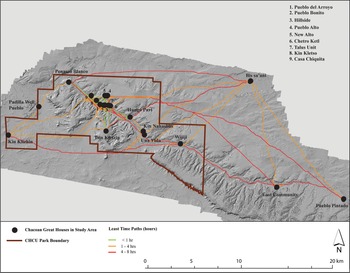
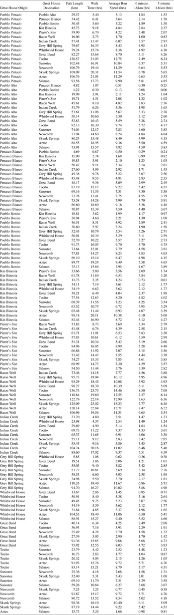
Not unexpectedly, the great houses in the canyon or on adjacent mesas have the fastest hiking and running times along routes that generally follow the valley bottom (Figures 2 and 3; Table 1; Supplemental Table 1). Great houses in “downtown Chaco” are just a few minutes apart, whereas the time between the two most distant great houses in the canyon core—Una Vida and Peñasco Blanco—is 1.09 hours for an average runner (or 0.64 for a fast runner). The potential for exchanging messages multiple times per day indicates a high degree of connectivity in the core. If we assume that the size of a great house and surrounding small sites is at least roughly equivalent to population (and as noted, not all Chaco specialists align with this assumption), the capacity for reaching lots of individuals quickly is obvious.
Time paths between the major eleventh- and twelfth-century AD great houses in the Chaco Core using Tobler's (Reference Tobler and Tobler1993) hiking function. (Color online)

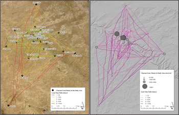
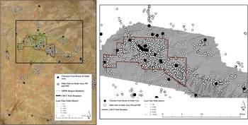
Time paths between all great houses in the primary study area based on Tobler's (Reference Tobler and Tobler1993) hiking function. Paths between each great house and all other great houses result in some overlapping and partially obscured pathways. The image on the left shows paths superimposed on satellite imagery; the image on the right is a terrain model generated from lidar.

Selected Travel Times between Great Houses.

For average hikers, most outlying (extra-canyon) great houses in the primary analysis are within two to three hours of one or more great houses located in the core. Running significantly reduces these times. For example, for an average runner, the time from Pueblo Bonito to Kin Bineola is 1.99 hours; to Kin Klizhin, 0.78 hours; and to Greenlee, 2.43 hours. The time between the two most distant great houses, Pueblo Pintado and Peñasco Blanco, is only 2.16 hours for a fast runner. Similarly, a fast runner could get from Bis sa'ani in the northeast to Kin Bineola in the west in less than 2.5 hours. These are idealized times, but clearly it would not have taken very long for messengers to move between the great houses in the study area.
Two clusters of small outlying great houses appear to have been important nodes in the potential communication pathways. The Escavada Complex / Greasy Hill / No Name Site group north of Chaco Canyon is just over an hour walk from Pueblo Bonito. South of the canyon, the Upper Kin Klizhin / Casa Patricio / Greenlee sites are approximately 2.8 hours from Pueblo Bonito. Schelberg (Reference Schelberg, Schelberg and James Judge1984) and Windes (Reference Windes2015) associate these groups of sites with agricultural production zones, possibly occupied primarily during the growing season.
Kin Ya'a is between eight and 10 hours from all large great houses in the study area for average hikers, and approximately six to seven hours from the Upper Kin Klizhin group. Kin Ya'a may have linked Chaco Canyon to a local timber source near Hosta Butte, a prominent landmark visible from several canyon great houses (Kantner and Kintigh Reference Kantner, Kintigh and Lekson2006). The turnaround time for messages involving average to fast runners between this southern outlier and Chaco Canyon would still have been a day or more, so it seems unlikely that Kin Ya'a was as closely tied to the Chaco Core with respect to messaging as other great houses.
Although it is apparent that Chaco Canyon was the primary artery for transmitting information through the great house population, it is interesting that great houses outside the canyon could have communicated relatively quickly with other outliers without messengers passing through “downtown Chaco” (Figure 1). Indeed, the overall network of time pathways between great houses exhibits an unexpected grid-like structure (Figure 3). This is the result of outlying settlements located in parallel tributaries at approximately the same distance from the main canyon. These outliers are situated at or near confluences of multiple shallow drainages with large runoff catchments and are surrounded by small, dispersed residential sites described as farming communities or villages originally established centuries earlier (Marshall et al. Reference Marshall, Stein, Loose and Novotny1979; Windes Reference Windes2015). Grids are efficient transit structures in modern cities, but this is not a good analog for the Chaco period. Instead, we think it is relevant that the many intersecting paths, including diagonal routes that crisscross the potential network, create a multitude of route options for messaging between great houses.
If we exclude Kin Ya'a, it appears that time pathways also describe two “rings” around the denser grid structure connecting the multiple small great houses (Figure 3). The inner ring consists of sites within one to two hours of the Chaco core, all of which exhibit tenth- and eleventh-century AD architectural styles and ceramic assemblages. The outermost ring is defined by three sites roughly 2.5–3.0 hours from the core that were either first established or grew in the twelfth century: Pierre's Site in the north, Bis sa'ani in the northeast, and Bee Burrow Ruin to the south (Marshall et al. Reference Marshall, Stein, Loose and Novotny1979; Powers et al. Reference Powers, Gillespie and Lekson1983). Pierre's Site and Bee Burrow are associated with the North and South Roads, respectively, as approximate midpoints between the core and the edges of the San Juan Basin (Kincaid Reference Kincaid1983; Roney Reference Roney and Doyel1992). Vivian (Reference Vivian1997:61) suggested that as the number of distant outliers expanded in the AD 1100s, communication became more difficult, which is consistent with the fewer time paths and increased route times evident in our analysis compared to great houses built in the AD 1000s (Figure 3). It is intriguing that their positions create roughly equivalent time paths to the core and to Pueblo Pintado and Kin Bineola, so it may be that the twelfth-century sites reflect a deliberate effort to maintain relatively uniform time paths within the expanding network of great houses.
Circumferential routes in modern societies are an efficient response to population growth, allowing traffic to bypass congested pathways in order to save time. Clearly, we do not envision runners backed up at intersections throughout the San Juan Basin, but from a social network perspective, it is possible that the increasing density of settlements around Chaco Canyon during the eleventh and twelfth centuries AD created a spatial web of interpersonal relationships both advantageous and disadvantageous to any individual—places of attraction but also of avoidance. Hence, as small great houses were built on the margins in areas with little evidence for earlier occupations, accompanied by an increase in the agricultural use of tributary drainages (Doyel Reference Doyel and Doyel1992; Wills Reference Wills2017), options for avoiding some settlements may have been as important as direct routes to every community. We can think about pathways developing as cultural land-use systems altered the spatial network of social relationships. Whether or not the geographic expansion of great houses intentionally created new communication nodes and therefore more options for messaging is unknowable, but the potential time pathways between great houses would have passed through a dense milieu of small habitations, agricultural fields, and miscellaneous other cultural features (Figure 4).
Overall distribution of archaeological sites dating from approximately AD 900 to 1150 and time paths between great houses in the primary study area. Chaco Culture National Historical Park has 100% survey coverage, as is strikingly evident at the park boundaries. Survey areas outside the park have irregular geographical coverage, corresponding mainly to energy extraction or targeted pedestrian surveys along prehistoric linear features (“Chaco roads”; see Kincaid Reference Kincaid1983; Kunitz et al. Reference Kunitz, Lagree and Weinig2017). Consequently, large portions of the study area do not have archaeological site information. It is probable that site density is much higher in the region around Chaco Canyon than indicated by these patterns and that time paths may predict undocumented archaeological sites locations. (Source: New Mexico Archaeological Records Management System, State of New Mexico Historic Preservation Division.) (Color online)

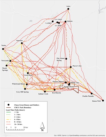
To the west of Chaco Canyon along tributaries to the Chaco River are a number of sites that are considered outliers or small great houses that are outside the primary study area. One of these, Skunk Springs, produced ceramics that were imported in large numbers to Chaco during the Bonito Phase (King Reference King2003). For comparison to the area around Chaco Canyon, we conducted pathways among eight of these sites (those identified as great houses by Fowler and Stein Reference Fowler, Stein and Doyel1992) and seven great houses in the Chaco Core, as well as the Salmon and Aztec great houses on the San Juan River (Figure 5).
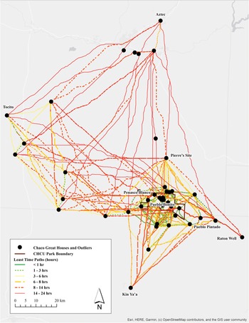
Time paths in the secondary study area. Great houses to the west of Chaco Canyon along the ephemeral Chaco River are small (range: 1–45 rooms; average: 14 rooms), whereas the Salmon and Aztec on the perennial San Juan River are the third- and seventh-largest Chacoan great houses, both dating mainly to the twelfth and thirteenth centuries AD. Ojo Alamo Spring is not a great house site but a notable historical water source that may also have been a source of Ponderosa pine beams during the Bonito Phase. LA 3028, LA 8612, and LA 13431 are small Chaco-era sites along the south bank of the San Juan River. (Color online)

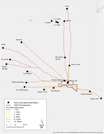
The results indicate that messaging times between these outliers and canyon great houses ranged between three and 14+ hours. Even among these sites, fastest times are generally more than three hours, suggesting that communication in this network was slower than in the denser settlement pattern centered on Chaco Canyon. Simple least cost paths between individual outliers and Pueblo Bonito exceed eight to 14 hours (except for Indian Creek, at three or more hours), placing these sites in the same messaging range as Aztec and Salmon to the north, and Kin Ya'a to the south (Figure 6). Although the western sites occur along the Chaco River, which seems to be a natural corridor, the main drainage was not the fastest route for transmission of messages to and from great houses in the core.
Individual time paths between sites in the secondary analysis. The Chaco River is a natural corridor connecting Chaco Canyon to outlying small great houses (Van Dyke Reference Van Dyke2007:158), but the fastest paths for messaging between most of these sites and Pueblo Bonito were northwest of the Chaco River along the Hunter Wash drainage. (Color online)

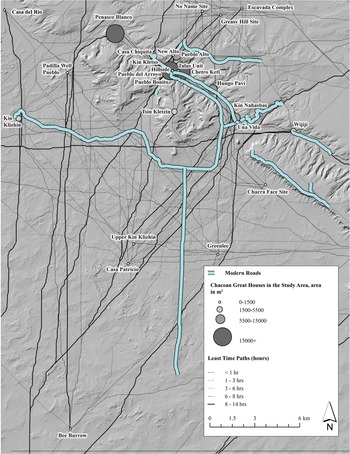
Finally, we plotted modern roads in order to determine whether any of the time pathways were a product of these features (Figure 7). Time paths along the canyon floor do closely follow modern roads, but this is hardly surprising given the relatively flat and spatially circumscribed valley. Outside Chaco Canyon, none of the modern roads imprint directly on time paths, although the road to Kin Klizhin follows a route that overlaps in places with multiple time paths between the great house and the canyon. Therefore, the modern roads do not affect our results.
Correspondence of modern roads to time paths in the Chaco Core.

Discussion
Drainages were likely the major movement corridors in the daily lives of most Chacoan people, with settlements and agricultural fields distributed along shallow watercourses. The time paths elucidated in our analysis would have connected these dendritic land-use systems, and they indicate that the fastest transmission of information may have been different in many cases from everyday mobility among settlements. It might be possible through fieldwork to determine whether any of these projected routes evince navigation aids such as stone cairns, although runners in the past certainly would have used landmarks such as rock formations or simple foot trails that are unlikely to be recognizable to modern researchers (see Jett Reference Jett1994; Kelly and Francis Reference Kelly and Francis2005). Nonetheless, despite the limitations of the archaeological record, we feel that the time paths in our analysis probably hew closely to a real landscape of movement (Snead et al. Reference Snead, Erikson, Darling, Snead, Erikson and Darling2009) integrating great houses and intervening areas.
It is almost trite to point out the centrality of Chaco Canyon great houses in this potential network of information exchange, given that the massing of great house architecture in the canyon has been well known to archaeologists since the early twentieth century. However, early suggestions based on remote sensing studies that the canyon great houses might have had a central managerial role with respect to controlling outlying settlements via formal roads (conduits between communities) clearly overlooked the potential of simple foot trails in communication networks. For example, messages could have been relayed through the entire network, regardless of the size of interacting entities, rather than transmitted directly from the center to each outlier and back. There were also many ways for messengers to move between great houses quickly without transiting the core or being observed from sites within it. Consequently, although the area encompassed by great houses in the dataset was undoubtedly strongly integrated through various relationships with the canyon communities (see Doyel Reference Doyel and Doyel1992; Mills et al. Reference Mills, Peeples, Aragon, Bellorado, Clark, Giomi and Windes2018; Plog Reference Plog and Whiteley2018), the welter of intersecting potential communication routes suggests that the overall flow of information through this area was not likely constrained by hierarchical controls.
Intervisibility and Signaling
Although we do not believe that complex transactional information required for labor mobilization was possible through simple messaging, such as light signals, “signaling” has been a persistent theme in discussions of great house connectivity. The first archaeologists to work in Chaco were impressed by the vast visual fields afforded by high elevations overlooking sparsely vegetated canyons and broad alluvial valleys, including lines of sight between many great houses. Hewett (Reference Hewett1936:20) speculated that an observer near Fajada Butte could have seen “signal fires” from at least 10 great houses within “a panorama of ruins that rivals the most noted places of antiquity in the Old World.” During the Bonito Phase, the unpolluted dark night sky undoubtedly revealed fires of myriad dispersed households, regardless of any intention to send signals. The assumption that people were able to send signals between Chaco communities by fire or some reflective material was largely a matter of common sense until the 1970s, when remote sensing researchers and archaeologists working for the National Park Service began to systematically investigate potential intervisibility patterns formed by the distribution of great houses and high elevation points (Doyel et al. Reference Doyel, Breterniz, Marshall, Judge and Schelberg1984; Hayes and Windes Reference Hayes, Windes and Frisbie1975).
At the same time, archaeologists studying possible Chaco era “roads” concluded that “the existence of the roadway system linking outlying sites to Chaco Canyon and each other suggested the possibility of a visual communication system” (Ebert and Hitchcock Reference Ebert, Hitchcock, Lyons and Mathien1980:150). Experiments with flares as proxies for signaling by fire were conducted and featured in the Public Broadcasting Service (PBS) documentary Chaco Legacy (1980). Recent studies have employed GIS analyses to determine the actual visual fields associated with individual great houses or features (Dalton Reference Dalton2000; Doxater Reference Doxater2002; Dungan et al. Reference Dungan, White, Déderix, Mills and Safi2018; Kantner and Hobgood Reference Kantner and Hobgood2016; Munro and Malville Reference Munro, McKim Malville and Ruggles2011; Van Dyke et al. Reference Van Dyke, Bocinsky, Windes and Robinson2016; for a trenchant review of experiential interpretations of landmarks and visibility, see Plog Reference Plog2010). Collectively, these efforts reveal that outside the lower portion of Chaco Canyon, great houses often were not intervisible and, in a few cases, they do not provide extensive fields of view, whereas not surprisingly, prominent high points on mesas can provide very long lines of sight in a welter of directions.
Although some researchers interpret these results to indicate a Bonito Phase signaling system as proposed in the 1970s (Van Dyke et al. Reference Van Dyke, Bocinsky, Windes and Robinson2016), there has been no empirical confirmation of any signaling mechanisms (fires, reflective devices) and little discussion of what types of information might have been conveyed by conjectured light signals. An overview of Indigenous North American signaling using fire and smoke (Beers Reference Beers, Condie and Crotty2014) indicates that this form of communication was primarily for warning of danger or locating hunting parties. Several archaeological studies in the American Southwest (other than Chaco) also emphasize warning functions (Haas and Creamer Reference Haas and Creamer1993; Mackey and Green Reference Mackey and Green1979). To our knowledge, there are no ethnographic examples from the Puebloan area for conveying messages via signaling other than binary information, such as the presence or absence of people in a particular place (and this seems to be based on a single, secondhand account reported by Ellis [Reference Ellis, Duran and Kirkpatrick1991]). In contrast, when Indigenous peoples in the region wanted to send complex messages, they sent messengers (Aguilar and Preucel Reference Aguilar, Preucel, Schmidt and Mrozowski2013; Liebmann Reference Liebmann2008), although a smoke signal might indicate that a message had been received (Folsom Reference Folsom1973). Consequently, although it plausible that great house communities or residents utilized signals, we deem this method unlikely to have had a necessary or significant role in mobilizing construction workers.
Chaco Roads and Time Pathways
Chaco “roads” are shallow, man-made linear depressions that have been intensively investigated since the early 1970s (Ebert and Hitchcock Reference Ebert, Hitchcock, Lyons and Mathien1980; Kincaid Reference Kincaid1983; Lyons and Hitchcock Reference Lyons, Hitchcock, Lyons and Hitchcock1977; Mathien Reference Mathien and Trombold1991; Nials et al. Reference Nials, Stein and Roney1987; Obernauf Reference Obernauf and Trombold1991; Sever and Wagner Reference Sever, Wagner and Trombold1991; Ware and Gumerman Reference Ware, Gumerman, Lyons and Hitchcock1977). The North and South Roads are many kilometers in length (although discontinuous in places), connecting Chaco Canyon to distant great house communities, or trunk routes in the sense of providing a major direct pathway from one center to another center or outlying community. Judge (Reference Judge, Cordell and Gumerman1989:243) proposed that “the sites of the Chacoan system were physically integrated by a road system that may have comprised five major segments, linking all but the northeast quadrant of the Basin.” Nevertheless, researchers have speculated earnestly about road functions without much resolution (Clark and Fritschle 2011; Judd Reference Judd1964:141–142; Kantner and Hobgood Reference Kantner, Hobgood, Forte and Williams2003; Kantner and Kintigh Reference Kantner, Kintigh and Lekson2006; Lekson Reference Lekson2009; Roney Reference Roney and Doyel1992; Snygg and Windes Reference Snygg and Windes1998; Sofaer et al. Reference Sofaer, Marshall, Sinclair and Aveni1989; Vivian Reference Vivian1997; Weinig Reference Weinig2017). And despite the persistent influence of popular assumptions about a Chacoan road “system” (see reviews in Ebert and Hitchcock Reference Ebert, Hitchcock, Lyons and Mathien1980; Kantner Reference Kantner2003; Snead Reference Snead2017), physical evidence for roads or trunk routes other than the North and South Roads remains elusive (e.g., Marshall Reference Marshall and Winter1994; Marshall et al. Reference Marshall, Stein, Loose and Novotny1979; Field et al. Reference Field, Heitman and Richards-Risetto2019).
In terms of transmitting messages, an obvious question then is whether the North and South Roads follow least cost corridors, and previous studies have shown that they do, although imprecisely, which probably reflects local decision making that incorporated variables such as water sources, local settlements, and so on (Heberling Reference Heberling2011; Kunitz et al. Reference Kunitz, Lagree and Weinig2017). Substantive dating continues to be a problem, but there seems to be general agreement that these major linear features were constructed as conveyances for the movement of people during the Bonito Phase, likely attended by symbolic meaning. For example, according to Van Dyke (Reference Van Dyke2007:148–151), “Builders not only engineered roads to symbolize elements of Chacoan ideology, but also constructed roads as formalized approaches into Chaco Canyon,” and “roads undoubtedly had cosmographic and symbolic purposes, but they also directed movement into and away from Chaco” (Van Dyke Reference Van Dyke, Alt and Pauketat2019:5; see also Malville and Malville Reference Malville and Malville2001). Otherwise, the majority of identified “roads” are attenuated features closely associated with great houses rather than routes to other major sites (Kincaid Reference Kincaid1983; Marshall et al. Reference Marshall, Stein, Loose and Novotny1979; Obernauf Reference Obernauf and Trombold1991; Roney Reference Roney and Doyel1992; Vivian Reference Vivian1997). These shorter features are now frequently interpreted in terms of social of cosmological roles in local communities rather than transportation or communication (Fowler and Stein Reference Fowler, Stein and Doyel1992; Marshall Reference Marshall, Morrow and Price1997:71; Roney Reference Roney and Doyel1992).
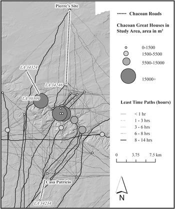
Our time pathways analysis leads us to conclude that the North and South Roads probably did not enhance information flow much (if at all) because they were not the only equivalent time pathways available between the same termini. It may be more informative that the clearest physical manifestations of these major routes occur where they cross interfluves with low relief and (currently) little vegetation. We see this relationship along an exceptionally well-defined segment of the South Road that intersects a least time-cost path rather than following it (Figure 8). This might indicate that the roads were navigation features between destinations (albeit expensive ones) and that like many of the projected time paths, they link parallel drainages.
Three documented prehistoric Chaco roads plotted against time paths and great houses in the Chaco Core (sites scaled by size; see Figure 3). The North Road section between Pierre's Site and LA 34246 follows time paths relatively closely. The Ah-shi-sle-pah Road links a trailhead (LA 30309) on a cliff edge to a major spring (LA 34324) and is not associated with communication routes between great houses. A particularly distinct segment of the South Road between Casa Patricio and LA 34234 crosses the time paths leading to Kin Ya'a (Figure 3).

Concluding Thoughts
We reiterate that our analysis does not directly measure communication but rather the potential for transmitting complex messages by walking or running along least cost time paths. The structure of time paths created by our analysis is a model for—not a demonstration of—interaction time between documented great houses as afforded by topographic variables chosen as relevant to the speed with which messengers could move between settlement nodes (Figure 9). Our results indicate that messengers could have transited the entire network of great houses in Chaco Canyon and its immediate tributaries in a few hours or less, and we propose that this time range likely defines the source area for the labor required by eleventh-century great house construction.
The primary and secondary path analyses combined. There are a number of Chaco-era great houses southwest of the combined study area that were not included in the analysis due to processing limitations. We do not think that adding these distant sites would alter our conclusions, but other researchers can use the code in Supplemental Text 1 to replicate our analysis for other sites. (Color online)

Our reasoning is fourfold:
(1) Beyond approximately three hours, time ranges to outlying sites in our analysis greatly increase, in nearly all cases exceeding eight hours. Consequently, the time required to contact potential sources of labor plus the time that labor would need to get to Chaco would be days. Once workers arrived in Chaco, every day there was a day lost to farming at home. We are not arguing that it was impossible to obtain construction labor from these outliers, but these time ranges would make it very difficult to coordinate scheduling conflicts resulting from unpredictable water availability.
(2) The western great houses or Chacoan structures beyond three hours’ messaging time are not large, and only a few are associated with many surrounding residential dwellings (Fowler and Stein Reference Fowler, Stein and Doyel1992; Marshall et al. Reference Marshall, Stein, Loose and Novotny1979), which means that the population along the Chaco River was widely dispersed and perhaps relatively small. We think it would have been a significant challenge to mobilize much labor rapidly from such a diffuse network.
(3) The great houses on the San Juan River were built after those in Chaco Canyon, which is typically explained by people from Chaco migrating out to new localities and enjoining local populations in construction (Brown et al. Reference Brown, Windes, McKenna and Reed2008).
(4) By most conventional archaeological measures of population size, the number and size of great houses and smaller residential buildings within three hours of downtown Chaco is consistent with a potential pool of hundreds of adult workers, which seems commensurate with Lekson's (Reference Lekson1984) labor estimates.
Hosting work parties through feasting and drinking was almost certainly part of the way that labor was supported (Aikins Reference Aikens, Judge and Schelberg1984; Crown Reference Crown2018), but we doubt that sustained construction work (as indicated by estimates of tens of thousands of person hours) by nonresidents was financed this way, just as modern examples of cooperative work parties—such as barn raising or crop harvesting—tend to be brief intensive events preceded by site preparation by smaller groups so that laborers can quickly return to their own responsibilities (Fitchen Reference Fitchen1986:56). Similarly, some timber may have been brought to Chaco Canyon by nonresidents as social or religious contributions to the construction enterprise (e.g., Kantner and Vaughn Reference Kantner and Vaughn2012), but beam procurement can also be explained hypothetically as ritualized activities by canyon residents alone (Wills Reference Wills and Mills2000). Consequently, to the extent that distant communities might have been engaged in building great houses in Chaco, their contributions seem likely to have been indirect with respect to construction work, so we suggest that the process of constructing Chaco—the physical assembly of stone, mortar, and beams to erect complex multistory structures through the coordination of serial production steps—was primarily an endeavor associated with the resident population of the canyon and tributary drainages.
Of course, our assumption that mobilizing labor for erecting great houses conflicted with farming practices may be wrong or overestimated. If the population residing in the canyon was larger than that posited by scholars who see great houses as largely nonresidential buildings and agricultural fields were near construction sites, then perhaps labor for construction projects could have been recruited locally without negatively impacting food production. Moreover, depending on how much building material had been stockpiled in advance (including water in reservoirs), labor might have been drawn from more distant communities for brief intervals that did not present significant conflicts with farming practices. We acknowledge this ambiguity and assume that colleagues will have varying degrees of comfort with our conclusions about the constraints associated with unpredictable flooding (and probably some of our other assumptions). If the scheduling conflicts seem overestimated, we at least contend that our results can be construed more narrowly to show how rapidly complex information could have moved throughout the network of great houses in and around Chaco Canyon.
Whether or not we are correct about labor sources, it seems important that the ease of communication between the great house communities elucidated by the pathway analysis implies that social distance within three hours of the canyon core was not great. Nodes formed by medium- to large-sized great houses occur in localities with long settlement occupation spans (or persistence) based on surface indicators, and they are likely to have embodied deeply entrenched ancestral ties with places on the land shared by individuals dispersed by spousal exchange through the various settlements (see Amsden Reference Amsden1992; Doyel et al. Reference Doyel, Breterniz, Marshall, Judge and Schelberg1984; Mahoney Reference Mahoney, Kantner and Mahoney2000; Schelberg Reference Schelberg, Schelberg and James Judge1984; Whiteley Reference Dungan, White, Déderix, Mills and Safi2018; Wills and Dorshow Reference Wills and Dorshow2012). Consequently, all adults living in this geographical range during the Bonito Phase probably could establish a social connection to one another. It is irrelevant (to our questions) how exactly individuals were related (e.g., which direction spouses may have moved in matrilocal, patrilocal, or uxorilocal systems), but most adults had kinship-based knowledge of one another derived from various “modes of interaction” over time (see Hamberger Reference Hamberger2018). In such a small world network (e.g., Uzzi et al. Reference Uzzi and Amaral2007; Watts and Strogatz Reference Watts and Strogatz1998), social proximity promotes and/or allows for extremely efficient and nuanced communication—precisely what is manifest in great house construction.
Acknowledgments
Funding for the research was provided by the University of New Mexico and the National Science Foundation (Grant Number BCS 1523224). The senior author wishes to thank Patrick Harjo (Diné) for conversations about running in general and running between great houses in particular, and Peter McKenna for ruefully agreeing to occasional post-excavation-day runs from Pueblo Alto to Una Vida. We are thankful to two anonymous reviewers and Ruth Van Dyke who provided excellent advice on the original submission, and to three anonymous reviewers who helped shape the revised submission. Richard Maestas translated the abstract into Spanish.
University of New Mexico People's Land and Territory Acknowledgment
Founded in 1889, the University of New Mexico sits on the traditional lands of the Pueblo of Sandia. Since time immemorial, the original peoples of New Mexico—Pueblo, Navajo, and Apache—have deep connections to the land and have made significant contributions to the broader community statewide. We honor the land throughout the generations and also acknowledge our committed relationship to Indigenous peoples. We gratefully recognize our history.
Data Availability Statement
The data utilized for this study are included in the text and supplemental material.
Supplemental Material
For supplemental material accompanying this article, visit https://doi.org/10.1017/aaq.2022.33.
Supplemental Text 1. Code for the Primary Analysis.
Supplemental Table 1. Complete Set of Time Estimates between Great Houses.
Competing Interests
The authors declare none.