INTRODUCTION
Conservation groups have embraced community-based conservation (CBC) efforts in various parts of the world (e.g. Brooks et al. Reference Brooks, Waylen and Borgerhoff Mulder2013). However, there are few evaluations of CBC conservation effectiveness using empirical evidence, due to a lack of investment, monitoring, inexpensive and accessible tools, practical approaches, quantitative analysis and available, accessible and comparable data (Salafsky et al. Reference Salafsky, Cauley, Balachander, Cordes, Parks, Margoluis and Margoluis2001; Kiss Reference Kiss2004; Marg oluis et al. Reference Margoluis, Stem, Salafsky and Brown2009; Roe et al. Reference Roe, Nelson and Sandbrook2009; Pellis et al. Reference Pellis, Anyango, Waterreus, Lamers and van der Duim2014). Here, we address some of these challenges by examining land-use outcomes on four CBCs located in Kenya. Significant proportions of Kenya's terrestrial wildlife populations (Western et al. Reference Western, Russell and Cuthill2009), including elephants (IUCN 2007), live outside or use lands beyond protected areas, and, in recent years, rising human and livestock populations and climate change impacts have driven precipitous wildlife declines (Ogutu et al. Reference Ogutu, Piepho, Said, Ojwang, Njino, Kifugo and Wargute2016). Further, the viability of wildlife movement routes and dispersal areas can be significantly compromised by land modification, associated habitat fragmentation and human settlement density (Douglas-Hamilton et al. Reference Douglas-Hamilton, Krink and Vollrath2005; Graham et al. Reference Graham, Douglas-Hamilton, Adams and Lee2009; Cushman et al. Reference Cushman, Chase and Griffin2010). Motivated by these conditions, and in order to create large conservation landscapes with the scope to maintain wildlife populations and ecological processes, conservationists have augmented government-protected areas by engaging private land holders in wildlife conservation (Henson et al. Reference Henson, Williams, Dupain, Gichohi and Muruthi2009). CBC strategies have been adopted across the non-governmental organization (NGO) continuum, from global organizations such as the World Wildlife Fund, to smaller efforts such as the Northern Rangelands Trust operating in Kenya (e.g. Carroll Reference Carroll1998; Greiner Reference Greiner2012). In many cases, NGO CBCs involve aid for economic development in exchange for community agreement to commit a portion of their land to conservation management (e.g. Kiyiapi et al. Reference Kiyiapi, Ntiati, Mwongela, Hatfield and Williams2005).
This study evaluates the performance of CBCs on four Kenyan group ranches in order to respond to calls for more empirical evaluations of conservation projects (Ferraro & Pattanayak Reference Ferraro and Pattanayak2006; Thomas & Koontz Reference Thomas and Koontz2011) that demonstrate evidence of conservation project achievements, rather than forgoing evaluation due to inherent challenges and complexities and low numbers of replicates (Margoluis et al. Reference Margoluis, Stem, Salafsky and Brown2009; Thomas & Koontz Reference Thomas and Koontz2011). This work also provides conservation NGOs with a quick, cost-effective, evidence-based evaluation method that harnesses increasingly accessible very-high-resolution (VHR) satellite imagery for application to a growing portfolio of CBC projects. Our intent is that this evaluation will inform the further development of CBC programme monitoring and evaluation strategies, in addition to the adaptive management decisions of the subject CBCs.
Group ranches are communal lands where the Kenyan government has registered a property title to families of largely pastoralist origin (Boone et al. Reference Boone, BurnSilver, Thornton, Worden and Galvin2005). The Kenyan government implemented the group ranch model in the mid-1960s to improve livestock management, resource sharing and development of infrastructure to support pastoralism (Boone et al. Reference Boone, BurnSilver, Thornton, Worden and Galvin2005; Mwangi Reference Mwangi2007). In recent years, sub-division, sedentarization, settlement expansion, livestock overstocking, variable rainfall and increased human–wildlife conflict have degraded group ranch wildlife populations (Georgiadis et al. Reference Georgiadis, Olwero and Romañach2007; Graham, et al. Reference Graham, Douglas-Hamilton, Adams and Lee2009) and pastoral livelihoods by reducing open space and access to grazing and water resources (Lamprey & Reid Reference Lamprey and Reid2004). Reduced livestock mobility has led to degraded rangelands and an increased permanence of settlements that compromises wildlife populations (Groom & Western Reference Groom and Western2013). Human–wildlife conflict imposes significant costs on pastoralists through livestock predation, human injury and fatalities and reduced access to natural resources (Gadd Reference Gadd2005; Muruthi Reference Muruthi2005; Blair Reference Blair2008). As traditional pastoral practices experience diminishing returns, pastoralists are exploring a range of adaptation strategies, including livelihood diversification into cultivation and tourism (Georgiadis et al. Reference Georgiadis, Olwero and Romañach2007).
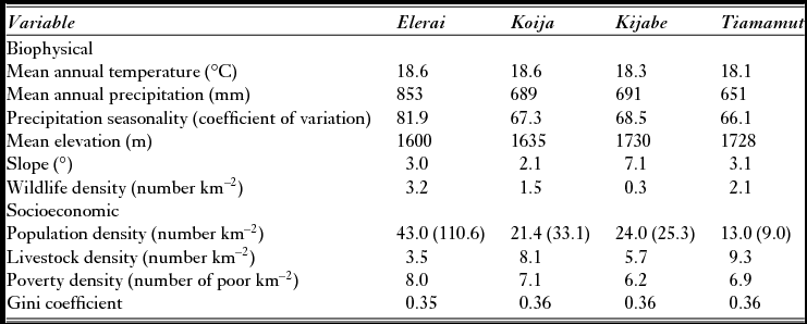
The group ranches in this study share many of these experiences and contribute to the conservation of relatively rich wildlife areas. Kijabe, Koija and Tiamamut are contiguous group ranches located in the core of Kenya's Laikipia–Samburu ecosystem, which hosts Kenya's second-highest density of wildlife (Georgiadis et al. Reference Georgiadis, Olwero and Romañach2007), including the largest population of elephants outside of protected areas (Litoroh et al. Reference Litoroh, Ihwagi, Mayienda, Bernard and Douglas-Hamilton2010). The Ewaso Nyiro River forms the western border of Koija and is the major water source for the region. Located close to the Tanzanian border, Elerai offers dispersal areas to savanna wildlife populations anchored by Amboseli National Park and buffers a major wildlife corridor linking Amboseli with a conservation complex containing Chyulu, Tsavo East and Tsavo West National Parks (Fig. S1, available online). Positioned at the base of the northeast slope of Mt Kilimanjaro, Elerai features relatively well-watered foothills that are suitable for cultivation, as well as lower-lying arid rangelands suited to livestock (Kiyiapi 2005). With a few exceptions, the CBC ranches share comparable biophysical, socioeconomic, governance and cultural aspects (Table 1). All are occupied by pastoralist Maasai peoples using communal grazing strategies; share similar temperatures (less than 1 °C range) and topographic profiles (mean elevation and slope ranges of less than 130 feet and 5°, respectively); and experience predominantly semi-arid precipitation patterns (Hijmans et al. Reference Hijmans, Cameron, Parra, Jones and Jarvis2005; Jarvis et al. Reference Jarvis, Reuter and A. Guevara2008). All are dominated by Acacia scrubland vegetation cover (Noad & Birnie Reference Noad and Birnie1990), partly overlap the southern Acacia–Commiphora bushlands and thickets ecoregion of Kenya (Olson et al. Reference Olson, Dinerstein, Wikramanayake, Burgess, Powell and Underwood2001) and have not experienced sub-division (Flintan & Puyo Reference Flintan and Puyo2012). Kijabe, Koija and Tiamamut occupy the Mukogodo division of Laikipia County and fall within the Ewaso Nyiro watershed, where semi-arid conditions constrain livelihood options to pastoralism, bee-keeping and, more recently, wildlife tourism. Wildlife-based tourism in both regions is challenged by human population growth, increased competition for land and water resources (Okech Reference Okech2010; Ogutu et al. Reference Ogutu, Piepho, Said, Ojwang, Njino, Kifugo and Wargute2016) and a protected area network that alone is inadequate for the long-term survival of many wildlife populations (Western Reference Western2001).
Biophysical and socioeconomic variables used to profile the four community-based conservation group ranches. Population density figures are from 1999 and 2009 (the latter are in parentheses).

Sources: WorldClim (climate variables, 1950–2000); CGIAR-CSI SRTM 90m v.4 (topography variables, 2008); Kenya Department of Resources Surveys and Remote Sensing (DRSRS) (wildlife density, 1994–1996); World Resources Institute and Kenya Central Bureau of Statistics (socioeconomic variables, 1999 and 2009).
Conservation NGOs have promoted CBCs as strategies for contributing to wildlife conservation at the landscape level, with tourism lodges often serving as the central economic incentive. Three of the four CBCs in this study (Elerai, Kijabe and Koija) involved development of a conservation lodge and are part of a larger trend of organizations using tourism-based enterprises to improve pastoral well-being and conservation management (BurnSilver Reference BurnSilver2009; Lamers et al. Reference Lamers, van der Duim, van Wijk, Nthiga and Visseren-Hamakers2014), while the fourth CBC (Tiamamut) involved no lodge, but emphasized pasture restoration and livestock management improvement (Fig. S1). Tiamamut's lack of a tourism enterprise aimed at providing an economic incentive for conservation management is its major distinguishing feature relative to the other CBCs in this study. Tiamamut could therefore be considered a ‘control’ unit for the lodge-driven CBCs. All four CBC projects were developed through a common participatory process, a partnership effort of each community and the African Wildlife Foundation (AWF) to create land-use plans with management zones. The premise of the CBC lodge approach is that: (a) local communities are best positioned to manage their land and deliver conservation results; and (b) jobs and benefits generated by the lodges and related tourism enterprises provide direct incentives for community implementation of the land-use plan. CBCs can create positive conservation impacts if community benefits are significant, well managed and equitably distributed (Rozemeijer Reference Rozemeijer2001).
This study presents a quantitative assessment of anthropogenic land modification and associated conservation results for the CBC group ranches. Our evaluation focused on the CBC management zones of conservation, livestock grazing, and settlement/cultivation, and addressed two questions: first, is there evidence that CBC group ranch management controlled development outcomes? Second, given a set of management zones, how well did development outcomes in the zones follow expectations? Our study does not investigate the socioeconomic drivers of CBC outcomes.
Each CBC community created a land-use plan in a participatory process that identified a range of management treatments for specific zones, which they then agreed to implement: a conservation zone that prohibits non-tourism development to enhance wildlife and tourism values; a livestock grazing zone that permits limited use of livestock enclosures and bomas (seasonal settlements) for pastoralism; and a settlement/cultivation zone that imposes few restrictions on development (Kiyiapi et al. Reference Kiyiapi, Ntiati, Mwongela, Hatfield and Williams2005; Sumba et al. Reference Sumba, Warinwa, Lenaiyasa and Muruthi2007). If these zones were managed in accordance with the land-use plans, we expected the lowest development rates in the conservation zones, the highest in the settlement/cultivation zones and intermediate levels in the grazing zones. The community and external stakeholders, including the Kenya Wildlife Service and AWF, designed the zones in each group ranch to support broader social and conservation objectives, including access to socioeconomic and biophysical resources and protection of conservation assets (Flintan & Puyo Reference Flintan and Puyo2012).
The CBC lodges have slightly different origins and starting dates. The Koija Starbeds Lodge opened in 2001, the Sanctuary at Ol Lentille in Kijabe opened in 2005 and the Satao Elerai Safari Camp opened in 2006 (Sumba et al. Reference Sumba, Warinwa, Lenaiyasa and Muruthi2007; Pellis et al. Reference Pellis, Anyango, Waterreus, Lamers and van der Duim2014). In 2002, the AWF engaged Tiamamut in a CBC agreement to rehabilitate degraded rangelands in exchange for undergoing a similar zoning process as its neighbours.
MATERIALS AND METHODS
We used manual analysis of VHR satellite imagery (less than 1 m in resolution) to assess CBC success at limiting development, as measured by the land-use change rates for structure density (huts, buildings and penstocks; livestock enclosures) (Fig. S2) and land modification (clearing and significant degradation of the natural land cover for cultivation, settlement and livestock production). Our approach centres on measuring changes in the areas occupied by these development indicators since the initiation of each CBC project to contemporary time. The indicators represent the vast majority of human activity in the landscape that could degrade wildlife habitat. This approach required a full and accurate inventory of the structures and land modification extents across the CBC management zones in order to evaluate management effectiveness. To determine suitable remote sensing imagery, we conducted a sensitivity analysis in order to evaluate sensor ability to precisely characterize ground features of interest (Boyle et al. Reference Boyle, Kennedy, Torres, Colman, Pérez-Estigarribia and Noé2014). We overlaid a global positioning system field inventory of development features from the Elerai group ranch taken in 2005 on imagery from a series of images from sensors ranging from 0.46 m to 4 m in resolution, and determined that VHR imagery of less than 1 m in resolution was required for reliable detection in this region.
We used VHR imagery from the Quickbird (0.61 m) and WorldView-2 (0.46 m) sensors to cover the CBC inception and contemporary time periods (Table 2). Both sources have been used in a range of mapping of human settlement applications (e.g. Asmat et al. Reference Asmat, Zamzami and Mansor2012), but can be expensive. Conservationists increasingly use Google Earth for its free access to VHR imagery and user-friendly interface (Fisher et al. Reference Fisher, Amos, Bookhagen, Burbank and Godard2012; Boyle et al. Reference Boyle, Kennedy, Torres, Colman, Pérez-Estigarribia and Noé2014). Our analysis used Quickbird imagery available via Google Earth across all sites and time periods, except for the contemporary period for Elerai, for which we purchased WorldView-2. The lack of suitable imagery for the inception period of the CBCs required us to exclude portions of Kijabe and Koija from the change analysis; our change analysis included 63% and 40% of Kijabe's and Koija's extents, respectively, and the entirety of Tiamamut and Elerai (Table 2). For the excluded areas, we mapped contemporary structures and anthropogenic land modification areas in the conservation zones of Kijabe and Koija in order to create a complete contemporary dataset across the CBCs.
Community-based conservation (CBC) initiation year, sensor, year and percentage of group ranch covered by source imagery for the onset and contemporary time periods.

Using standard Geographic Information System (GIS) techniques, we recorded structures at inception as points and land modification areas as polygons. To capture features systematically, we draped a 2.5-km2 grid over the study area and inventoried features, one grid square at a time. We then overlaid the baseline datasets atop contemporary imagery and determined which features persisted, were added or were removed between the time periods.
Across each management zone and time period, we tabulated the land-use extent and inventoried structures by first applying ArcMap's ‘Identity’ command in ArcGIS 10.1 (ESRI 2012) to the structure observations. Subsequent application of the ‘Summary’ function on the attribute table of the ‘Identity’ product enumerated structure additions, removals or persistence over the time periods. From this inventory, we calculated the change in structure density over time.
These GIS techniques enabled us to create two threat-based development indicators that are relevant to wildlife conservation within CBC management zones: (1) net changes in structure density; and (2) percentage of net natural area converted by anthropogenic land use (land modification). With structures clearly discernible on the imagery, structure density change provides an unambiguous index of human influence. Land modification captures the area extent of potential wildlife habitat that has been compromised or lost to human activity. The three CBC tourism lodge projects introduced limited tourism-related development in accordance with land-use plans. Our paper therefore focuses primarily on non-tourism development impacts; all results involve non-tourism impacts, unless stated otherwise.
RESULTS
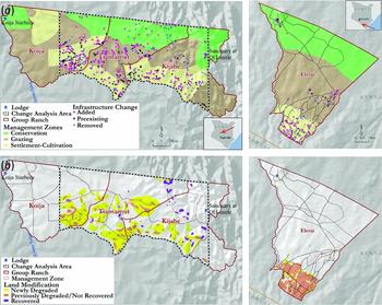
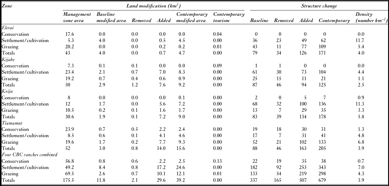
Satellite imagery revealed significant changes in structures and land modification (Fig. 1(a) and (b)). Across all group ranches, the collective addition of non-tourism structures and area of land modification were highest for the CBC settlement–cultivation zones (253 structures and 17.2 km2), intermediate in the grazing zone (219 structures and 10.1 km2) and lowest in the conservation zones (35 structures and 2.2 km2) (Table 3). For the four group ranches, the settlement–cultivation, grazing and conservation zones also experienced the highest to lowest changes in net structure density (3.3, 2.4 and 0.3 km–2, respectively) and land modification percentages (33%, 13.5% and 2.9%, respectively) (Table 3). Tourism-related land modification in the three lodge CBCs occupied averages of 0.49%, 0.02% and 0.00% of their respective conservation, grazing and settlement zones.
Community-based conservation development changes observed between baseline and contemporary periods via interpretation of very-high-resolution satellite imagery: (a) structures (huts, buildings and livestock pens) and (b) land modification areas. Land modification areas experienced clearing or significant degradation/regrowth of natural vegetation cover due to development expansion or contraction. Elerai land modification also involved cultivation.

Structure and land-use changes observed across community-based conservation (CBC) management zones. The contemporary modified area for each management zone is calculated as the baseline area minus the total area removed, plus any area added since inception. All figures are non-tourism, unless otherwise stated. Baseline and contemporary imagery data for Elerai were from 2005 and 2011; for all others, we used 2002 and 2011/2013.

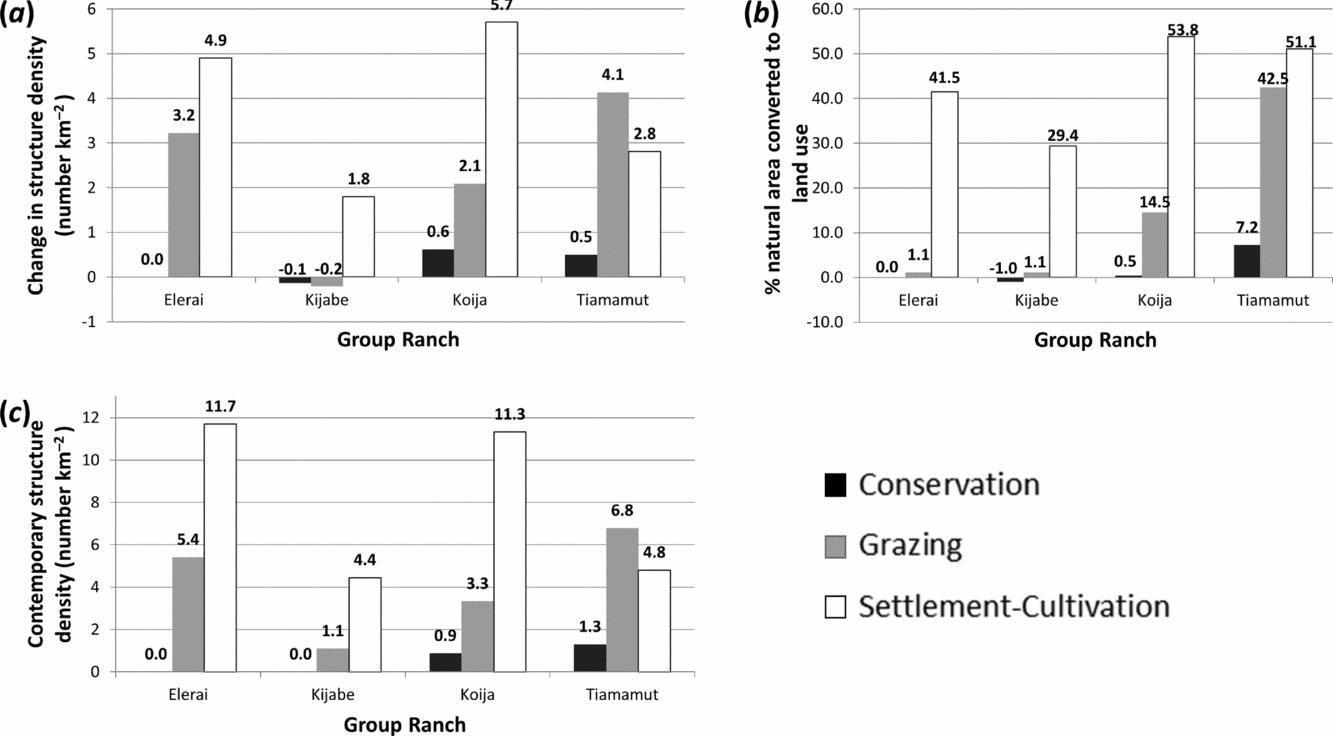
Kijabe's conservation zone recorded the highest level of land modification at 1.3%. The rate of change in structure density and land modification for the three CBCs with lodges was highest in the settlement–cultivation zone, intermediate in the grazing zone and lowest in the conservation zone (Fig. 2(a) and (b)). The conservation zones for Elerai and Kijabe posted zero or negative changes for both indicators. Koija recorded the highest conservation zone rate of structure density change and land modification of the three CBCs with lodges.
Bar charts of non-tourism land-use extent and development structures as interpreted from very-high-resolution satellite imagery for Elerai group ranch and the analysis area spanning Kijabe, Koija and Tiamamut group ranches. (a) Net change in density of structures across management zones. (b) Percentage of natural areas within management zones that were significantly degraded or converted due to land modification. (c) Density of contemporary structures across management zones.

The change in Tiamamut differed in that its grazing zone recorded the highest structure density change rate, while its conservation zone posted the lowest rate (Fig. 2(a)). Compared to the other CBCs, Tiamamut's conservation and grazing zones posted significantly higher rates for both indicators, with one exception: its conservation zone structure density change rate was slightly lower than Koija's (Fig. 2(a)). Tiamamut's conservation zone land modification rate, however, was 14-times greater than that for Koija (Fig. 2(b)), and it maintained a higher contemporary conservation zone structure density (Fig. 2(c)).
With the exception of one building in Tiamamut, non-tourism contemporary structures in Tiamamut's and Koija's conservation zones were all bomas/huts and livestock enclosures. CBC tourism operation buildings inside the conservation zones featured lodges and support structures, while the contemporary land-use footprint also included firebreaks and wildlife viewing areas. Our review of contemporary VHR imagery in Kijabe's eastern and Koija's western conservation zone sections, which were excluded from the historical change analysis due to a lack of historical imagery, revealed no non-tourism development in the contemporary period.
DISCUSSION
Our evaluation suggests that development levels in the CBCs best aligned with conservation management objectives at ranches where tourism lodges had been constructed (Kijabe, Koija and Elerai). Development in Kijabe's and Elerai's conservation zones was considerably lower than in Tiamamut's conservation zone, while results in Koija were more muted. Tiamamut's relatively weak performance in our study, despite it being the only CBC with a declining human population, strengthens the evidence that CBC lodges helped control development in the grazing and conservation zones. While our results do not indicate a causal relationship, the different levels of structure density and land modification among the ranches support the assertion that CBC lodges contributed to conservation objectives.
The use of remote sensing data to measure development in conservation zones was a simple way to evaluate the degree to which land was being held open for conservation. We found that development in Kijabe and Koija was lower relative to Tiamamut. While ours are simply measures of degree of development, our positive conservation findings are supported by contemporary, independent ecological research that has recorded the effects of CBC practices on mammals, natural vegetation and range conditions. Field surveys found that Kijabe's and Koija's CBC programmes generated more positive conservation impacts when compared with that of Tiamamut in terms of vegetation species richness, vegetation biodiversity and range conditions (Lara Reference Lara2011). A multi-temporal, remote sensing analysis found that Kijabe's and Koija's conservation and grazing zones collectively experienced recent net increases in vegetation cover, while the same zones in Tiamamut experienced net losses; in addition, Kijabe's and Koija's conservation zones experienced higher vegetation growth than their respective grazing areas (Lara Reference Lara2011). These field survey and remotely sensed findings are consistent with our observations of relative development levels across management zones, and they corroborate our finding that Kijabe's performance surpassed Koija's. Other field research found that Kijabe's conservation area exceeds Tiamamut's in terms of grass cover, herbaceous species diversity and richness and soil parameters (Mureithi et al. Reference Mureithi, Verdoodt, Njoka, Gachene, Warinwa and Van Ranst2014).
Tiamamut's and Koija's lower performance levels appear to stem from their lax adherence to their own grazing bylaws in the conservation zone, which resulted in higher grazing levels. Independent interviews of group ranch members confirm widespread unauthorized grazing in Tiamamut (Mureithi et al. Reference Mureithi, Verdoodt, Njoka, Gachene, Warinwa and Van Ranst2014) and Koija's conservation zones, but not in Kijabe (Lara Reference Lara2011). Another assessment identified livestock overgrazing by group ranch members and outsiders as the major threat to Koija's conservation zone (Oguge et al. Reference Oguge, Mireri and Onjala2006). Overall, these independent field-based assessments corroborate our strong positive threat-mitigation findings in Kijabe and Elerai, followed by Koija's more modest results. Below, we discuss the changes observed in each of the group ranches in more detail.
Kijabe's effectiveness at controlling development in contrast to Tiamamut's expansion is reinforced by the absence of contemporary development in the eastern section of Kijabe's conservation zone, where we only examined current imagery; these areas were probably undeveloped at the beginning of the CBC ranch efforts, or development was removed. That Kijabe's Ol Lentille conservancy has expanded its conservation area over seven-fold through agreements with neighbouring communities is likely reflective of the positive socioeconomic and environmental benefits generated by the CBC. Group ranch members have attributed improvements in rangeland condition, wildlife numbers and human capital to the CBC (SNV 2010).
Like Kijabe, Elerai has a single-section conservation zone anchored by a conservation lodge, and it performed well by our measures, despite having a significantly higher population density and experiencing far higher population growth than the other CBCs. The presence of structures and land use within a kilometre to the east of Eleria's conservation zone suggests conditions there are amenable for development, and it is likely that the conservation zone is suppressing development.
By both land-use change measures, Koija's conservation and grazing zones clearly performed worse than Kijabe or Elerai. Koija's conservation zone experienced similar structure density change to Tiamamut's, but significantly less land modification, which suggests that its conservation zone outperformed Tiamamut's in terms of controlling overall development. The predominance of settlements and livestock enclosures in Koija's and Tiamamut's conservation zones suggests that both communities use them predominantly for grazing and transitional pastoralist settlements, as opposed to more permanent land uses. The absence of contemporary non-tourism development in Koija's western conservation zone section, which contains the Koija Starbeds Lodge and is separated from the eastern section by 4 km of mostly settled land, suggests that it might be valued more for wildlife tourism and/or subject to better management oversight than the eastern section.
Lacking a motivating tourism driver, Tiamamut's members appear to manage their conservation zone more for grazing than for conservation and wildlife tourism. An independent survey of Tiamamut group ranch members concluded that Tiamamut “does not follow the natural resources management program strictly” (Lara Reference Lara2011), perhaps explaining the weak enforcement of the conservation and grazing zones.
Taken in conjunction with population trends, other remote sensing analyses suggest that the study CBCs are limiting development in the conservation zones when compared with peripheral communities. Landsat image assessments (D. Williams, unpublished data 2014) of 5-km peripheral zones around Eleria and the combined Koija, Kijabe and Tiamamut expanse demonstrated higher 2000–2010 land modification rates (5.0% and 6.3%, respectively) relative to our conservation zone results (0% and 2.9%, respectively), despite occupying areas with far lower human population densities and population growth rates (Republic of Kenya 1999, 2009).
By involving easily understood inputs and outputs, cheap and rapid data collection and basic GIS techniques, we offer conservationists an accessible, straightforward and replicable approach for site-level evaluation of conservation threats in savannah and grazing ecosystems. Remote sensing presents an effective means of evaluating impact absent land-use and structure distribution data collection at the onset of a conservation project. Satellite imagery represented the largest cost involved in this work, followed by staff time. However, image availability is increasing and cost is falling (Belward & Skøien Reference Belward and Skøien2015); emerging small satellite platforms such as Planet Labs aim to dramatically increase the delivery and accessibility of VHR imagery, while freely accessible virtual globes such as Google Earth provide expanding image libraries. Multi-temporal VHR satellite imagery is, however, an underutilized resource for conservationists and geographers (Fisher et al. Reference Fisher, Amos, Bookhagen, Burbank and Godard2012; Nagendra et al. Reference Nagendra, Lucas, Honrado, Jongman, Tarantino, Adamo and Mairota2013; Boyle et al. Reference Boyle, Kennedy, Torres, Colman, Pérez-Estigarribia and Noé2014). Our approach demonstrates the conservation utility of VHR imagery, which is well suited to delivering faster, more cost-effective development metrics and evaluation results relative to ground or aerial surveys.
Our study offers an approach that is systematic yet simple to apply and, unlike other CBC assessments demonstrating little or inconclusive evidence of success (Kiss Reference Kiss2004; Roe et al. 2009), found clear positive results of reduced development where expected. As our study is limited to visual observations of development in community-defined management zones, we recognize external factors (e.g. climate change) might have played a role in creating the observed patterns of land use. It was beyond the scope of this study to attribute the observed development patterns solely to CBC management plans and the influence of conservation lodges.
A range of options are available for evaluating conservation success. Impact evaluations apply experimental or quasi-experimental designs in order to systematically examine the causal effect of an intervention, looking for the changes in outcome that are directly attributable to the intervention rather than confounding factors (Gertler et al. Reference Gertler, Martinez, Premand, Rawlings and Vermeersch2011), and they can be critical to understanding what interventions work and under what conditions (Ferraro Reference Ferraro2009). Impact evaluations can involve the selection of ‘matching’ intervention units with comparison or counterfactual units using statistical tests of similarity, and they are recognized for their ability to provide strong evidence of causality (e.g. Ferraro & Pattanayak Reference Ferraro and Pattanayak2006; Ferraro Reference Ferraro2009). However, they have been sparsely applied by conservationists, as their implementation can be prohibitively expensive, require substantial expertise or are stymied by real-world complexities that preclude counterfactual selection (Margoluis et al. Reference Margoluis, Stem, Salafsky and Brown2009; Lele et al. Reference Lele, Wilshusen, Brockington, Seidler and Bawa2010). Our study lacked sufficient numbers of group ranches to define study and counterfactual groups using statistical selection techniques for applying an experimental design to this evaluation. Extension of this study in that direction might involve additional CBC group ranches, as well as the inclusion of an equal number of counterfactual, non-conservation lodge or non-CBC group ranches. While such an expansion was beyond the scope of this effort, it could potentially strengthen the statistical significance of our findings. As it is, our study could be characterized as a performance assessment (or performance evaluation) that measured progress towards community-specified group ranch objectives, including desired conservation outcomes (Stem et al. Reference Stem, Margoluis, Salafsky and Brown2005; Mascia et al. Reference Mascia, Pailler, Thieme, Rowe, Bottrill, Danielsen and Burgess2014). We feel more confident in our results, however, because independent field surveys of vegetation, wildlife, rangeland and soils corroborate our remotely sensed CBC findings.
With African wildlife experiencing unprecedented and accelerating land modification, habitat loss and fragmentation, we believe that this threat-based approach could help conservationists by tapping the unexploited potential of VHR imagery (Nagendra et al. Reference Nagendra, Lucas, Honrado, Jongman, Tarantino, Adamo and Mairota2013) in order to generate rapid, inexpensive, frequent and accurate impact evaluations of CBCs that would contribute to improved conservation area adaptive management and planning. Elucidating the specific mechanisms through which the CBCs influenced development patterns would require further research into the socioeconomic and governance factors involved. Future research could explore automated object recognition methods to accelerate the identification of development features and reduce costs further without compromising results.
ACKNOWLEDGEMENTS
We thank Brian McBrearity and Fumi Kikuyama for their thoughtful comments on an earlier version of this manuscript and the communities of the four group ranches involved in this paper for making this work possible. Amielle DeWan provided constructive feedback on preliminary thinking on how this work fit into approaches for evaluating conservation success.
FUNDING
Research was carried out with funding from the Royal Netherlands Embassy in Kenya (RNE: 23856) and the United States Agency for International Development (SCAPES: EEM-A-00-09-00011).
Supplementary material
For supplementary material accompanying this paper, visit https://doi.org/10.1017/S0376892917000418