

Each First Nations’ community has a unique way of knowing, learning and teaching traditions’ to their youth (McNally, Reference McNally2004, p. 604). Historically, this knowledge was generally transmitted orally and by watching and observing (Tsuji, Reference Tsuji2000), with many lessons being focused on skills and knowledge that were valuable to surviving in and adapting to the environment (Battiste, Reference Battiste2002; McNally, Reference McNally2004; Wheaton, Reference Wheaton and Roger2000). This understanding of the environment allowed First Nations people to adapt to environmental change (Woodland Heritage Services, 2004). However, socio-cultural changes have reduced First Nations people's ability to adapt to a changing environment (Berkes, Colding, & Folke, Reference Berkes, Colding and Folke2000; Ford et al., Reference Ford, Smit, Wandel, Allurut, Shappa, Ittusarajuats and Qrunnuts2008; McDonald, Arragutainaq, & Novalinga, Reference McDonald, Arragutainaq and Novalinga1997; Tsuji & Nieboer, Reference Tsuji and Nieboer1999), as there has been disruption in the intergenerational transmission of Indigenous knowledge (Tsuji, Reference Tsuji1996a, Reference Tsuji1996b). Indeed, residential schooling resulted in a loss of language, culture, and knowledge among the younger generations (Ball, Reference Ball2004; Ford et al., Reference Ford, Smit, Wandel, Allurut, Shappa, Ittusarajuats and Qrunnuts2008). In addition, technological changes in field transportation, such as the use of snow machines and outboard motors (and canvas/fiberglass boats), have decreased the time that family units spend together in the bush, with day and weekend trips by hunters (without their families) becoming more common (Berkes et al., Reference Berkes, Hughes, George, Preston, Cummins and Turner1995; Cummins, Reference Cummins1992; Tsuji & Nieboer, Reference Tsuji and Nieboer1999). As technological changes in transportation have somewhat diminished the family aspect of harvesting activities, there has similarly been a significant reduction in time where Elders and experienced bushmen are connecting with the younger generations in the bush. Thus, technological changes from outside cultures are a contributing factor in the transmissional disruption of Indigenous knowledge between generations. The loss of knowledge, coupled with an accelerated rate of environmental change, has made it challenging for northern Indigenous communities to adapt, and has the added potential to increase Indigenous youths’ vulnerability to climate change impacts (Ford et al., Reference Ford, Smit, Wandel, Allurut, Shappa, Ittusarajuats and Qrunnuts2008; Huntington & Fox, Reference Huntington and Fox2005).
Postman (Reference Postman1993, pp. 28) uses the term ‘technocracy’ to define society's use of technology to ‘attack a culture’ and/or ‘control’ it, in the name of ‘development’. The technology becomes a larger part of the culture under pressure causing other aspects, such as, ‘tradition, social mores, politics, ritual and religion’ to be diminished or replaced (Postman, Reference Postman1993, p. 28). For northern Canadian Indigenous communities, the attack on their culture came during the colonisation of the country, where Euro-Western culture and lifestyle was forced upon the Indigenous communities, including the technologies that were seen to make the Indigenous societies more ‘advanced’ (Tuhiwai Smith, Reference Tuhiwai Smith1999). Recently, there has been a growing amount of community-based research initiated in northern Indigenous communities, utilising Western technology in order to address several issues: the growing gap between Elders and youth; the need to collate, store, and transfer Indigenous Knowledge; the need to incorporate Indigenous knowledge in land use planning; and the need to increase adaptive capacity through the use of Indigenous knowledge (Baikie et al., Reference Baikie, Shiwak, Wolfrey, Cunsolo Willox, Harper and Edge2012; Barbeau, Isogai, McCarthy, Cowan, & Tsuji, Reference Barbeau, Isogai, McCarthy, Cowan and Tsuji2011; Gardner-Youden et al., Reference Gardner-Youden, McCarthy, Cowan, Barbeau, Edwards, Tsuji, Bidwell and Winschiers-Theophilus2011b; Pulsifer, Parsons, McNeave, Gearheard, & Huntington, Reference Pulsifer, Parsons, McNeave, Gearheard and Huntington2012; Riggs, Reference Riggs2004; Simpson, Reference Simpson2004). Technology is now being used not for assimilation but for cultural preservation, in that the communities have control of and are using technology as tools to aid them in meeting the goals of their community (Dyson, Reference Dyson, Ciborra, Mercurio, De Marco, Martinez and Carignani2003; Gardner-Youden et al., Reference Gardner-Youden, Barbeau, McCarthy, Edwards, Cowan and Tsuji2011a, Reference Gardner-Youden, McCarthy, Cowan, Barbeau, Edwards, Tsuji, Bidwell and Winschiers-Theophilus2011b; Kral, Reference Kral2010; Robbins, Reference Robbins2003; Wattchow, Reference Wattchow2001). In the present study, the community is a partner in the creation of the technology from the beginning design stages all the way to implementation (Gardner-Youden et al., Reference Gardner-Youden, Barbeau, McCarthy, Edwards, Cowan and Tsuji2011a; McCarthy et al., Reference McCarthy, Whitelaw, Anderson, Cowan, McGarry, Robins and Tsuji2011).
In an effort to address environmental information management issues (the collection, storage, retrieval and sharing of knowledge, both ‘Western science’ and Indigenous knowledge) with respect to environmental change, and to foster adaptive capacity building in the western James Bay region of northern Ontario, Canada, we introduced a potentially useful, web-based, collaborative-geomatics informatics tool. This tool has been field tested in the western James Bay communities, and community feedback has been used to modify the tool to the specification of the users (Gardner-Youden et al., Reference Gardner-Youden, Barbeau, McCarthy, Edwards, Cowan and Tsuji2011a; McCarthy et al., Reference McCarthy, Whitelaw, Anderson, Cowan, McGarry, Robins and Tsuji2011). Once the functionality of the informatics tool is deemed satisfactory by the test community, Indigenous knowledge collection can begin; however, this does not preclude further modification of the tool if required. It should be emphasised that once the tool has been modified to meet the users’ needs, the informatics tool will be given over as a stand-alone system at no cost to the community, and no further outside access from the researchers to the tool. Nevertheless, the community can request assistance of any type (e.g., technical, system updates) from the researchers with the stand-alone system. This approach has been adopted because access to the Indigenous knowledge stored on the informatics tool is an intellectual property right issue; thus, the community must have full control over their intellectual property. Even during the formative phase of the informatics tool, security safeguards (e.g., password protection) are used; in other words, access to some types of Indigenous knowledge is not open even to the researchers (Gardner-Youden et al., Reference Gardner-Youden, Barbeau, McCarthy, Edwards, Cowan and Tsuji2011a; McCarthy et al., Reference McCarthy, Whitelaw, Anderson, Cowan, McGarry, Robins and Tsuji2011). As stated by the Fort Albany First Nation Chief (Barbeau et al., Reference Barbeau, Isogai, McCarthy, Cowan and Tsuji2011).Footnote 1
We want to get to that security, where we feel really comfortable when we get the information . . . and all this data collection stays in the community . . . some place to store that information, as long as it's secure. The other thing is that I think we have to learn how to really progress with the times . . . making sure that we are very knowledgeable [with respect to all knowledge systems].
The collaborative-geomatics informatics tool supports a common reference map based on high-resolution imagery. This tool has real-time capabilities and allows remote communities to monitor and share knowledge (e.g., oral, written and visual [photographs and videos]) and work in collaboration with specified groups, in a secure system with accessibility safeguards. During community testing of the viability of the collaborative-geomatics informatics tool in Fort Albany First Nation, community members commented that the collaborative informatics tool may also be a useful tool to help foster intergenerational transfer of Indigenous knowledge and have youth become more aware of their land:
I can see this [collaborative-geomatics informatics tool] being used by the students of the school . . . where things are . . . family relationships . . . [students] love taking pictures . . . [Students could record] the [river-ice] break up dates . . . the amount of snowfall, mean temperatures or daily temperatures . . . it's a good project for students . . . It is what the elders used to do anyway, keep track of everything . . . transferring everything into the [collaborative geomatics] library and that's where we find all this stuff. Animal names, vegetation names . . . where certain types of animal are . . . to be aware of [what] the land looks like. (Participant 10, as cited in Barbeau et al., Reference Barbeau, Isogai, McCarthy, Cowan and Tsuji2011, p. 121)
It would be good, for the new generation that's coming up. They'll know what's going on, and it would be handy like, be good for the schools . . . So they [schoolchildren] will know their ancestors and their culture, fishing, trapping, the land, everything. It would be great . . . they are into this . . . Internet thing. This is good, really good . . . they would know more about their land . . . the history . . . (Participant 7)
It . . . would benefit a lot if it [the collaborative-geomatics informatics tool] was programmed in the school, like for the kids to learn . . . it would encourage them to go out . . . (Participant 5)
History of our land, I know I have a lot of ideas. I don't go out in the bush a lot [now], but I think this will [help preserve our] . . . history . . . what we went through when we were young . . . for the kids now. It's very different from way back. I find there's a lot of changes and it's good for a system like [the collaborative-geomatics informatics tool] . . . to be in place . . . or even getting the elders to teach you how to do this sort of stuff. I mean how to trap beavers [and you could video tape that] and then put it on there. (Participant 9)
Beats a textbook for sure. (Participant 6)
Elders also commented on the tool's potential to be used in the community:
Yeah it's simple enough. Like I would have to adapt to it like, like anything. You try something new, you have to get used to it first, before you can use it. (Participant 1)
First time you're mesmerized by the buttons, by the squares by the lingo that you use . . . the poly line, for me I don't know what a poly line is. Until you click it . . . then I see you can understand what a poly line is, terminology, we'll get used to that. (Participant 10)
In this pilot study, we continue to assess the potential of the collaborative-geomatics informatics tool by examining its capacity to connect today's youth with bushmen, Elders, and the land — allowing for intergenerational knowledge transfer — in an effort to rebuild adaptive capacity in Fort Albany First Nation. Our research team has been involved in community-based participatory research with Fort Albany First Nation for over 25 years,Footnote 2 and the present initiative is an extension of this partnership.
Methods
Study Area
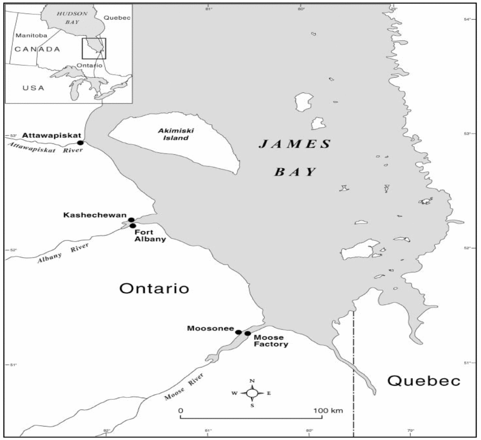
Fort Albany First Nation is located in northern Ontario, Canada. The community proper is located on Sinclair Island in the Albany River, with people also living on the mainland and nearby Anderson Island; the population is approximately 850 people (Tsuji, Reference Tsuji1996a) (see Figure 1). Being a remote community, it is only accessible year-round by airplane; while, in the winter months a snow-ice road connects Fort Albany First Nation to the other coastal James Bay First Nations and the community of Moosonee (where there is rail service). During the ice-free seasons, barge transportation is available from Moosonee to the coastal First Nations. Education is provided to the youth of Fort Albany at Peetabeck Academy, which is under the control of the Mundo Peetabeck Education Authority (a First Nation-administered organisation similar in function to a Board of Education). The school contains facilities to educate children from pre-kindergarten to Grade 12, following the Ontario curriculum. However, Cree language classes are also part of the curriculum, and various cultural activities also occur throughout the school year.
Map of the Mushkegowuk Territory in western James Bay, Ontario, Canada (Karagatzides et al., Reference Karagatzides, Kozlovic, De Iuliis, Liberda, General, Liedtke and Tsuji2011).

Community-Based Participatory Research
Guided by community-based participatory research methods, the initial need for an informatics tool was brought forward from the community, and the iterative design of the informatics tool was a partnership exercise between community members (e.g., the Band Council, the locally elected government of the First Nation; land use planning staff; health services personnel; Education Authority personnel) and the research team (Castelden, Garvin, & Huu-ay-aht First Nation, Reference Castleden and Garvin2008; Gardner-Youden et al., Reference Gardner-Youden, Barbeau, McCarthy, Edwards, Cowan and Tsuji2011a; McCarthy et al., Reference McCarthy, Whitelaw, Anderson, Cowan, McGarry, Robins and Tsuji2011). Semi-directive interviews and focus groups were conducted with community members to determine the suitability of the informatics tool — at this stage it could have been rejected outright — and an alternative informatics tool would have to have been developed or bought (McCarthy et al., Reference McCarthy, Whitelaw, Anderson, Cowan, McGarry, Robins and Tsuji2011). As the collaborative-geomatics informatics tool was found to be suitable for the needs of the community, recommendations for modifications of the tool (informed by the semi-directive interviews and focus groups) were brought back to the Computer Systems Group at the University of Waterloo (Barbeau, Reference Barbeau, Isogai, McCarthy, Cowan and Tsuji2011; McCarthy et al., Reference McCarthy, Whitelaw, Anderson, Cowan, McGarry, Robins and Tsuji2011). This iterative process of ‘acting, observing and reflecting’ is an important part of participatory research (Kemmis & McTaggart, Reference Kemmis, McTaggart, Denzin and Lincoln2000, p. 596). The development and customisation of the informatics system itself is meant to support a collaborative process throughout, rather than during just the initial planning stage which is often seen in ‘conventional software design’ (Barbeau et al., Reference Barbeau, Isogai, McCarthy, Cowan and Tsuji2011; Gardner-Youden, Reference Gardner-Youden, Barbeau, McCarthy, Edwards, Cowan and Tsuji2011a; McCarthy et al., Reference McCarthy, Whitelaw, Anderson, Cowan, McGarry, Robins and Tsuji2011, pp. 310). The community members are more than just participants in the research, in that they help to guide/facilitate the research process and there are direct benefits from the research for them, rather than just for the outside researchers (Berg, Reference Berg2004, p. 196). The present project continues the process of participatory research by engaging the youth in utilising the tool and gaining their perspectives on it, in order to further assess the tool to make any necessary changes (Berg, Reference Berg2004).
Collaborative-Geomatics Informatics Tool
The collaborative-geomatics informatics tool enables ‘a participatory approach to both the development and use of online, distributed-authority, geomatics applications’ (McCarthy et al., Reference McCarthy, Whitelaw, Anderson, Cowan, McGarry, Robins and Tsuji2011, p. 310). Geomatics focuses on organising ‘geographically referenced data, visualisation of data on maps and graphs, and the spatial analysis of data’ (Cusimano, Chipman, Glazier, Rinner, & Marshall, Reference Cusimano, Chipman, Glazier, Rinner and Marshall2007, p. 51). Our tool is similar to GIS as it is also a mapping tool; what makes this tool unique from other GIS technologies is the Web Informatics Development Environment (WIDE) toolkit that allows for a forms-based (or wizards-based) approachFootnote 3 to system construction that supports the rapid development and modification of the system (Cowan, Fenton, & Mulhoulland, Reference Cowan, Fenton and Mulhoulland2006; McCarthy et al., Reference McCarthy, Whitelaw, Anderson, Cowan, McGarry, Robins and Tsuji2011). Thus, the WIDE toolkit allows for greater community engagement by supporting the relatively rapid customisation of each collaborative-geomatics informatics tool being informed by community input in a relatively short period of time (Cowan et al., Reference Cowan, Fenton and Mulhoulland2006; Gardner-Youden, Reference Gardner-Youden, Barbeau, McCarthy, Edwards, Cowan and Tsuji2011a; McCarthy et al., Reference McCarthy, Whitelaw, Anderson, Cowan, McGarry, Robins and Tsuji2011). The WIDE toolkit was developed by the Computer Systems Group of the University of Waterloo; the toolkit supports the collection, collation and presentation of geo-spatial data (including GIS) on high resolution satellite imagery using a collaborative social network (Cowan et al., Reference Cowan, Fenton and Mulhoulland2006; McCarthy et al., Reference McCarthy, Whitelaw, Anderson, Cowan, McGarry, Robins and Tsuji2011). Our informatics tool is similar to Public Participation/Participatory GIS, as our tool focuses on including a more public audience, collaboration between users and groups of people and a wider distribution of data (McCarthy et al., Reference McCarthy, Whitelaw, Anderson, Cowan, McGarry, Robins and Tsuji2011). Due to being entirely web based, the cost of the collaborative-geomatics informatics tool is significantly lower compared to other GIS software. It was specifically designed to be user friendly and can be used by most people with a short lesson (McCarthy et al., Reference McCarthy, Whitelaw, Anderson, Cowan, McGarry, Robins and Tsuji2011).
Educational Approach
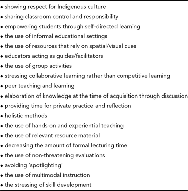
The cultural discontinuity hypothesis suggests that when the classroom environment is incongruent with the home environment or past experiences, there is limited opportunity to engage Indigenous children in the learning process (Rohner, Reference Rohner1965). Adding to this issue, there is an ambiguity associated with identifying what are Indigenous learning styles, as there are almost 150 different First Nations in Ontario alone. Nonetheless, we need a starting point from which to design an educational environment that is conducive to engaging Indigenous children in the learning process. Thus, we have identified from the published literature educational strategies that tend to result in greater Indigenous student success in North America (see Table 1). With our outreach program, we have employed all the educational strategies in Table 1, in an effort to more fully engage the youth.
Educational Strategies Shown to Have a Positive Impact on the Academic Performance of North American Indigenous Students*
Note: *modified from Karagatzides et al., Reference Karagatzides, Kozlovic, De Iuliis, Liberda, General, Liedtke and Tsuji2011. Sources: Dick, Estell, & McCarty, Reference Dick, Estell and McCarty1994; Dumont, Reference Dumont, Cazden, John and Hymes1972; Feurer, Reference Feurer1992; Foreman, Reference Foreman1991; Irwin & Reynolds, Reference Irwin and Reynolds1992; Leith & Slentz, Reference Leith and Slentz1984; Miller & Thomas, Reference Miller and Thomas1972; More, Reference More1987; Pepper & Henry, Reference Pepper and Henry1986; Rhodes, Reference Rhodes1988; Sawyer, Reference Sawyer1991; Wilgosh & Mulcahy, Reference Wilgosh and Mulcahy1993; Wilson, Reference Wilson1992; Wright, Reference Wright1998; Zwick & Miller, Reference Zwick and Miller1992.
Our Environmental Outreach Program
Our research team, in partnership with the Mundo Peetabeck Education Authority, has held a community-based environmental-science outreach camp in Fort Albany over the past 8 years. The camp connected youth with environmental science and technology mentors and contextualised all activities to subarctic Ontario. Activities highlighted environmental concerns related to environmental change; these concerns were raised by community members (e.g., shoreline changes; Karagatzides et al., Reference Karagatzides, Kozlovic, De Iuliis, Liberda, General, Liedtke and Tsuji2011). Through consultation with the community, the program was developed for students in Grades 6–8, with a focus of getting them interested in environmental science and technology as a possible post-secondary education path (Karagatzides et al., Reference Karagatzides, Kozlovic, De Iuliis, Liberda, General, Liedtke and Tsuji2011, p. 204). Students were taken out on the land by environmental studies/sciences professors, graduate students, and experienced bushmen. They participated in activities, such as studying carnivorous pitcher plants and the impacts of contaminants on these plants, as well as searching for fossils, and discussing why marine fossils are now found in freshwater areas and on land (the answer is due to post-glacial isostatic rebound; Karagatzides et al., Reference Karagatzides, Kozlovic, De Iuliis, Liberda, General, Liedtke and Tsuji2011). Many youth looked forward to participating in the camp, as those who participated in the camp in previous years have many positive memories and often come back.
In continuing partnership with the community, the potential use of the collaborative-geomatics informatics tool by youth was examined at a summer outreach camp. The outreach camp was used to introduce the informatics tool to youth of Peetabeck Academy entering Grades 6–8 (in the 2011 school year), during a 5-day camp in late July, 2011. Community members were recruited to help facilitate activities in the camp and play an active role in transferring knowledge and information about the land and environment to the youth. Participating members were chosen based on their extensive knowledge of traditional activities in the surrounding area, and had full control over how the activities were executed (Berg, Reference Berg2004; Kemmis & McTaggart, Reference Kemmis, McTaggart, Denzin and Lincoln2000). Only 10 children were recruited for this camp, as we wanted a small group to optimise the mentoring experience with community ‘bushmen’ and the Elder (Blatchford, Bassett, & Brown, Reference Blatchford, Bassett and Brown2005; Karagatzides et al., Reference Karagatzides, Kozlovic, De Iuliis, Liberda, General, Liedtke and Tsuji2011). In our previous community-based environmental outreach camps, it was found that informal educational settings, activities that relied on spatial/visual cues, collaborative activities in small groups, and hands-on and experiential teaching contextualised to the community and surrounding environment (e.g., the wetlands of the James Bay coast) were most effective in engaging the schoolchildren (Karagatzides et al., Reference Karagatzides, Kozlovic, De Iuliis, Liberda, General, Liedtke and Tsuji2011). The use of these types of educational strategies among First Nation youth have been reported to be culturally appropriate (Battiste, Reference Battiste2002; Biermann, Reference Biermann2008; Maina, Reference Maina1997; McNally, Reference McNally2004; More, Reference More1987; Wheaton, Reference Wheaton and Roger2000; see Table 1). These educational strategies as well as the others described in Table 1 were used for the present outreach initiative; however, conducive to our approach, we were prepared to adapt the program as needed to ensure that it was meeting the youths’ needs and abilities (Berg, Reference Berg2004; Kemmis & McTaggart, Reference Kemmis, McTaggart, Denzin and Lincoln2005, p. 563).
The outreach program gave students the opportunity to interact with the collaborative-geomatics informatics tool, while participating in traditional activities. For example, one activity centered around the harvesting of whitefish (Coregonus spp.) from the Albany River. The children were paired with camp leaders (e.g., professors, graduate students, or the one high school student from Peetabeck Academy who had participated for 3 years in our previous environmental camps) and one of four experienced bushmen. As the Albany River was particularly dry during the summer of 2011, river-water levels were a determining factor on when river travel was safe, especially taking into account the daily tides. When on the river, the children helped the four bushmen set nets and check them the following day for fish. Any fish caught were taken to the Elder who showed them how to clean and smoke the fish. The children were able to taste the fish that they helped harvest and smoke. Hikes around the community were another important activity, as they allowed students to share the knowledge they had gained from their parents/Elders/others about their community. For example, several trails were explored around the community where students (and camp leaders) identified and consumed the various edible berries (e.g., strawberries, Fragaria spp. and raspberries, Rubus spp.) and interesting plants (e.g., Labrador tea, Rhododendron spp.).
Global Positioning System
The Garmin Oregon 550 GPS was chosen due to its user-friendly interface, durability, and most importantly, its ability to take geo-tagged photographs (i.e., longitudinal and latitudinal coordinates were associated with each photograph taken). In educational venues, various Geographical Information System (GIS) software and handheld devices are being introduced as a way to enhance learning for students, by having them explore their community and apply skills from the classroom into the real world (Broda & Baxter, Reference Broda and Baxter2002; Christie, Reference Christie2007; Churchill, Kennedy, Flint, & Cotton, Reference Churchill, Kennedy, Flint and Cotton2010; Sugimoto, Ravasio, & Hitoshi, Reference Sugimoto, Ravasio and Hitoshi2006). GIS software acts as a tool that allows users to create maps that display and analyse data, such as watersheds, utilising various geographical scales (Cusimano et al., Reference Cusimano, Chipman, Glazier, Rinner and Marshall2007). In many First Nations communities, GIS software is integral for documenting traditional lands and activities for planning and development purposes (Chapin, Lamb, & Threlkeld, Reference Chapin, Lamb and Threlkeld2005; Tobias, Reference Tobias2000). However, these GIS systems are often expensive to purchase and require ‘experts’ to fully utilise them (Gardner-Youden et al., Reference Gardner-Youden, Barbeau, McCarthy, Edwards, Cowan and Tsuji2011a, Reference Gardner-Youden, McCarthy, Cowan, Barbeau, Edwards, Tsuji, Bidwell and Winschiers-Theophilus2011b; McCarthy et al., Reference McCarthy, Whitelaw, Anderson, Cowan, McGarry, Robins and Tsuji2011).
The GPS devices were used as a tool for youth to further explore their community and record their activities. Each day the youth used the camera on the GPS to record all their interactions with the land and activities, in the form of photographs; their pictures were then transferred by the students (with help from the camp leaders after a demonstration) into the collaborative-geomatics informatics tool. Prior to the loading of their photographs, each student created an account with the help of a camp leader. The students were then shown how to use the collaborative-geomatics informatics tool through a hands-on demonstration. The lesson went over how to use the online tools (e.g., map tools: zooming in and out, viewing photographs, videos and using audio), uploading and viewing data. With some help from camp leaders, the students used their global positioning system (GPS) devices to upload one of their favourite geo-tagged photographs to the informatics tool. The students were then able to see spatially on the high-resolution satellite imagery map where they had taken that photograph and relate it back to the experience they had.
The GPS device was also used to develop and apply students’ orienteering skills through activities, such as, geocaching. Geocaching is a game requiring the use of a compass and map to locate ‘treasures’, in this case, Indigenous knowledge.
Evaluation
A qualitative mixed method design (a combination of field notes, participant observation, photographs and semi-directed student interviews) was used to explore the potential utility of using the collaborative-geomatics informatics tool, as an adjunctive tool, for the transmission of Indigenous knowledge (Barbeau et al., Reference Barbeau, Isogai, McCarthy, Cowan and Tsuji2011; Bryman, Reference Bryman2001; Churchill et al., Reference Churchill, Kennedy, Flint and Cotton2010; Heath & Walker, Reference Heath, Walker, Heath and Walker2012). We use the word ‘adjunctive’, as the informatics tool is meant to complement the Indigenous knowledge transference system, not replace it. All students present on the last day of camp were asked general questions to encourage discussion about the program and the collaborative-geomatics informatics tool.
Questions on whether the youth enjoyed participating in the camp provided insight on what activities they enjoyed and what they had learned about. Further questions regarding using the GPS devices, the collaborative-geomatics informatics tool, and whether they were simple to use and understand, provided initial information on whether the system had the potential to be used by youth to connect with the land. Interviews were transcribed verbatim and analysed using both deductive and inductive thematic coding by the primary author (ADI) and confirmed by one of the co-authors (LJST).
Results and Discussion
GPS Devices
Overall students quickly learned to use the GPS devices and enjoyed using them. When youth were asked what they liked about using the GPS devices, two themes emerged from their responses: 1. the use of the camera and 2. using the GPS to geocache.
1. Use of the Camera
[I liked] taking pictures of what we found and what we looked at [and] where we went. (Participant #3)
The process of taking photographs while out on the land and uploading them to the collaborative-geomatics informatics tool allowed youth to connect with the land and community members. In this way, the youth directly gained knowledge about their culture and community (transfer of intergenerational knowledge), while also indirectly contributing to the storage and transfer of knowledge to other community members (Wang & Burris, Reference Wang and Burris1997; Wang, Morrel-Samuels, Hutchison, Bell, & Pestronk, Reference Wang, Morrel-Samuels, Hutchison, Bell and Pestronk2004).
2. Geocaching
. . . going scavenger hunting [geocaching] those treasure thingies [geocaches] . . . using the GPS. . . going in the bush looking for them [geocaches] . . . that was kind of fun . . . (Participant #1)
When introducing the geocaching activity many of the youth mentioned that they had learned about maps and longitude and latitude in class; the use of the GPS devices allowed them to directly apply this knowledge in a real-life situation (Broda & Baxter, Reference Broda and Baxter2002; Sugimoto et al., Reference Sugimoto, Ravasio and Hitoshi2006;). Many First Nation communities across Canada are using maps and mapping technology to record information about traditional lands, hunting grounds, and abiotic and biotic features of cultural significance, in order to protect their land and resources, as well as prepare for the growing amount of development planned for Canada's north (Chapin et al., Reference Chapin, Lamb and Threlkeld2005; Gardner-Youden, Reference Gardner-Youden, Barbeau, McCarthy, Edwards, Cowan and Tsuji2011a; McDonald et al., Reference McDonald, Arragutainaq and Novalinga1997; Pulsifer et al., Reference Pulsifer, Parsons, McNeave, Gearheard and Huntington2012; Simms, Reference Simms2010). The skills used by the youth in the activities are important for ensuring that First Nation communities are able to continue to adapt to the changes occurring in and around their community, while protecting their culture and land (Chapin et al., Reference Chapin, Lamb and Threlkeld2005; Tobias, Reference Tobias2000; Turner, Reference Turner2005). Having more community members with the skills to utilise technologies, such as the collaborative-geomatics informatics tool and GPS devices, reduces the need for outside ‘experts’. Building up capacity of this type gives the community greater control over how the data are collected, processed and interpreted, which is a growing concern for many First Nation communities who are dealing with resource development issues (McCarthy et al., Reference McCarthy, Whitelaw, Anderson, Cowan, McGarry, Robins and Tsuji2011; Tobias, Reference Tobias2000; Youden, Reference Youden2010).
The Collaborative-Geomatics Informatics Tool
Most students were able to use the informatics tool on their own, after a short lesson. When asked about the ease of using the informatics tool, students were split in their opinion, some finding it relatively difficult, other students finding it very easy to use. Difficulty with the tool seemed to arise from the layout of the tool and navigating through the system.
It had all these stuff [pages] coming up and using a lot of things [having to navigate a lot] (Participant #3)
There were enough camp leaders available to help students navigate through the system and answer any questions they had regarding the use of the tool. The youth had a difficult time explaining in the interview why they found the system hard to use; however, comments during the use of the tool were noted during participant observation. For example, the process for signing up for an account and uploading photographs took too long and students grew impatient filling in the required sections. These issues were brought up with the Computer Systems Group at the University of Waterloo and have been rectified and successfully field tested with the youth at a subsequent outreach camp.
When the students were introduced to the collaborative-geomatics informatics tool, they were shown how to use it and were given a chance to explore it, by locating their community, uploading photographs and then viewing each other's photographs and other data uploaded to the system (e.g., videos, articles; Figures 2, 3, and 4).
Screenshot of the collaborative-geomatics informatics tool, displaying a photograph taken by a student of where strawberries can be found.
Screenshot of the collaborative-geomatics informatics tool, displaying a photograph taken by a student of the bog they visited during the camp.
Screenshot of the collaborative-geomatics informatics tool, displaying a photograph taken by a student during a boat ride along the Albany River.
When asked for what purposes they would use the system for, answers centred on using the informatics tool for traditional activities, such as, hunting and fishing:
To look up where you can like [go] . . . hunting . . . I would look on that thing [collaborative-geomatics informatics tool] and someone might have marked it [hunting area] somewhere and you can go back over there and go hunt over there. (Participant #1)
Finding a spot to go fishing or something. (Participant #3)
Look for whitefish. (Participant #1)
The youth were able to see the tool's potential in connecting them to the land and associated traditional activities. The tool allowed the youth to come into the activities with knowledge and skills that they were strong in (using technology) and share this knowledge with the bushmen, while also learning about the traditional activities and knowledge of the area (Kral, Reference Kral2010). Cultural activities such as hunting and fishing are an important part of the Cree culture in Fort Albany; participating in these activities allowed youth to gain knowledge from community members about the surrounding environment, history and methods they currently use in order to sustain their land and resources (e.g., hunting certain animals during specific seasons in order to ensure the population can sustain itself; Tsuji, Reference Tsuji1996a; Tsuji & Nieboer, Reference Tsuji and Nieboer1999). This knowledge is very important for cultural sustainability, but also for the community's future ability to adapt to the changes and challenges predicted for Canada's north (Ford et al., Reference Ford, Smit, Wandel, Allurut, Shappa, Ittusarajuats and Qrunnuts2008; Huntington & Fox, Reference Huntington and Fox2005; McDonald, Arragutainaq, & Novalinga, Reference McDonald, Arragutainaq and Novalinga1997). The youths’ ability to use the technology with very little training in order to document the places they visited further supports the findings by Barbeau et al. (Reference Barbeau, Isogai, McCarthy, Cowan and Tsuji2011) that the collaborative-geomatics tool has the potential for the youth (and in general, the community at large) to learn to use this Western technology, and use it in a way that is beneficial to them (Aikenhead, Reference Aikenhead1997; Simms, Reference Simms2010; Tobias, Reference Tobias2000).
During the interview and use of the informatics tool, the students made positive comments about the system's ability to upload and share the photographs they had taken and view each other's photographs (see Figures 2, 3, 4). The students enjoyed navigating through the map to view each photograph uploaded and sharing stories or experiences with locations they visited (Broda & Baxter, Reference Broda and Baxter2002; Okada, Yoshimura, Tarumi, Moriya, & Sakai, Reference Okada, Yoshimura, Tarumi, Moriya and Sakai2002).
The bog [was one of my favourite places I visited]. It's quite an experience learning. [I liked] learning about plants. [I liked] to look at the places where I took pictures of . . . the pitcher plant [Sarracenia purpurea] . . . [at the] end of the dikes and you go to that trail and . . . you end up [in the bog]. (Participant #4)
[I liked] . . . how it [the collaborative-geomatics informatics tool] showed you where you took the picture. (Participant #2)
The bog [was one of my favourite places I visited] . . . cause you can find those pitcher plants . . . No [I had never been there before and I did not know that the bog existed] . . . [I also liked] . . . looking at the Albany River and looking where we were at or where we went and posting that . . . horse [a piece of wood that looked like a horse] picture. (Participant #3)
The geospatial-visual aspect of the system really appealed to the students, which is what the community members had initially predicted (Barbeau et al., Reference Barbeau, Isogai, McCarthy, Cowan and Tsuji2011). The visual support provided by the technologies created a bridge between the youth and the land by allowing them to learn about the land, even when not on it, through the uploaded data on the informatics tool.
The Environmental Outreach Program
Nothing can (or should) replace the actual contextualisation of hands-on lessons in the bush, which is why it was important to include these activities in the outreach program with the collaborative-geomatics informatics tool (Lertzman, Reference Lertzman2002; Smith, Reference Smith2002; Tafoya, Reference Tafoya1995; Tsuji, Reference Tsuji2000; Turner, Reference Turner2005). The use of the technologies with the traditional activities provided students with a practical example of how the technology and activities can be used in real life situations, and how Western technology can be used with Indigenous culture in a complementary way (Aikenhead, Reference Aikenhead1997; Dyson, Reference Dyson, Ciborra, Mercurio, De Marco, Martinez and Carignani2003; Kral, Reference Kral2010; Robbins, Reference Robbins2003; Wattchow, Reference Wattchow2001).
When the students were asked about their favourite activities they had participated in and places they had visited during the camp, they all mentioned the boating activities on the Albany River with the bushmen. On these trips, students were taught the following by the bushmen: what time of season that you put the nets out, as whitefish are only plentiful during certain times of the year; what time of day you take the boats out to set the nets, and what time of day you check the nets, as the tides have to be accounted for; the importance of the location of the nets; how to set the nets; how to check the nets; and the different species of fish that are in the Albany River. Students were also shown how to clean and smoke the fish they had harvested by a community Elder, who also narrated the process in the Cree language. The hikes around the community where students were shown culturally interesting areas, flora and fauna, provided contextualised lessons in traditional food foraging and connected well with the traditional activity of harvesting of fish. The skills and knowledge associated with foraging, fishing and even orienteering are all traditional activities that have been handed down for generations and have been a part of the First Nations’ ability to adapt to their dynamic environment (McDonald et al., Reference McDonald, Arragutainaq and Novalinga1997; Simms, Reference Simms2010; Tsuji & Nieboer, Reference Tsuji and Nieboer1999).
Some of these lessons were oral, some were through observation, some were by actually doing the activity, and others were a combination of all of the above. It was important that the youth participated in these activities for multiple reasons; one of them being that many youth do not have the opportunity to participate in traditional activities on a regular basis or at all due to the cost to the family and/or the lack of knowledge (Tsuji & Nieboer, Reference Tsuji and Nieboer1999). Second, it was integral that the community was a key part of the program, because cultural information should ideally be taught by the holders of that knowledge either directly and/or remotely (e.g., video; Dold & Chapman, Reference Dold and Chapman2011; Kemmis & McTaggart, Reference Kemmis, McTaggart, Denzin and Lincoln2000; Smith, Reference Smith2002). Finally, the activities engaged in during the present initiative allowed the youth to see how technology can be used out on the land for various purposes and in a manner that was beneficial to their community and culture (Aikenhead, Reference Aikenhead1997; Castleden et al., Reference Castleden and Garvin2008; Ngai & Keohn, Reference Ngai and Koehn2010; Okada et al., Reference Okada, Yoshimura, Tarumi, Moriya and Sakai2002; Riggs, Reference Riggs2004).
Conclusion
The outreach program worked well in connecting youth with knowledgeable community members allowing for the direct transfer of traditional knowledge in a culturally appropriate manner, that is, learning through observation and doing, as well as other culturally-appropriate educational strategies (see Table 1). In addition, the informatics tool supported the archiving of this knowledge through the uploading of geospatially tagged pictures taken by the youth (see Figures 2, 3, 4), and uploading of associated video clips (e.g., an Elder smoking of fish with instructions in Cree). In this way, camp experiences were stored for later viewing and/or shared with other youth (and other community members) who were not present at the camp; that is, the informatics tool has the ability to facilitate indirect transfer of traditional knowledge. This route of transmission needs to be explored further, because even though youth have good technological skills and can see the potential of the informatics tool, it does not mean they will actually use the informatics tool for this purpose. Thus, future research will assess what methods should be used to further engage youth in using the collaborative-geomatics informatics tool; a fall 2011 after-school program with 10 schoolchildren and a summer 2012 program with 15 youth in Fort Albany have been completed and more outreach programs are being planned.
Acknowledgments
We would like to thank the community of Fort Albany for their participation in this research, especially the students of Peetabeck Academy, and staff of Peetabeck Academy, Mundo Peetabeck Education Authority, Peetabeck Health Services, and the Band office. We also thank the Social Sciences and Humanities Research Council of Canada for support, as well as the Northern Scientific Training Program (Department of Indian Affairs and Northern Development).
About the Authors
Andrea Isogai holds a Masters degree in Environment and Resource Studies at the University of Waterloo. Her research centres on engaging youth in a summer outreach science camp program. Through the outreach program, youth have participated in traditional activities, local knowledge and environmental monitoring. A collaborative geomatics informatics tool, meant to aid in future planning and development, has also been used to help the youth make connections to the land, culture and other community members.
Dr Daniel D. McCarthy is a faculty member with Social Innovation Generation and the Waterloo Institute of Social Innovation and Resilience, as well as an assistant professor in the Department of Environment and Resource Studies at the University of Waterloo. His interdisciplinary academic background has focused on exploring the utility of complex systems-based approaches to understanding and intervening in linked social, ecological, and epistemological systems. He has strong research interests and partnerships that relate to fostering adaptive capacity, social and environmental justice and social innovation in the field of environmental policy. He works closely with several First Nations groups in both northern and southern Ontario, as well as conservation and environmental movement organisations in the greater Toronto area, Ontario.
Holly L. Gardner is a PhD candidate at the University of Waterloo in the Department of Environment and Resource Studies, focusing on land use planning and development with an emphasis on the social and environmental impacts on Indigenous people.
Jim Karagatzides is a Professor in the School of Environmental Studies at Georgian College, Barrie, Ontario, Canada.
Skye Vandenberg has a Bachelor of Science in Environmental Science, and is currently pursuing a Masters Degree in Environmental Studies at the University of Waterloo. Her First Nations ancestry drives her to seek research topics in Indigenous communities.
Christine Barbeau is a PhD Candidate in Environment and Resource Studies, University of Waterloo. Her research focuses on environmental change in the subarctic and the promotion of increased adaptive capacity in First Nation communities.
Nadia Charania is a PhD Candidate and Vanier Canada Graduate Scholar at the University of Waterloo in the Department of Environment and Resource Studies. Her general research interests include public health, emergency disease management, communicable disease control, and community-based participatory research methods.
Vicky Edwards resides in the First Nation community of Fort Albany, Ontario. She has been actively involved within the community's school, Mundo Peetabeck Academy, holding roles as a teaching assistant and within the Aboriginal Head Start on Reserve Program. She has been working with our research team as an associate by conducting interviews and gathering data within the community.
Donald Cowan is Distinguished Professor Emeritus at the University of Waterloo. He received his education at the Universities of Toronto (BASc — 1960, Engineering Physics), Waterloo (MSc — 1961 and PhD — 1965, Applied Mathematics) and was awarded an honorary DSc from the University of Guelph (2011). His current academic specialisations include software engineering, software applications, and web-based and mobile information systems incorporating geomatics. He is an ACM Distinguished Scientist, Member of the IEEE, the Canadian Information Processing Society and a Fellow of the Institute of Combinatorics and its Applications.
Leonard J.S. Tsuji is a Professor of Environment and Health at the University of Waterloo in the Department of Environment and Resource Studies, and School of Public Health and Health Systems, and specialises in First Nation environmental issues.