Between town and country: spatial processes as a continuum?
The development of modern settlements and settlement spaces is characterized by extraordinary levels of dynamism. Processes of urbanization take place within a global context, demonstrating an often-irregular pattern of growth in cosmopolitan centres and, at the same time, triggering a profound transformation of the rural spaces exposed to the political, economic and cultural climate of these centres. The dramatic growth in towns in Asia – in particular in India and China – is paradigmatic for these processes. Urban movements of expansion and contraction have many different causes, but they always stand in some relationship to the surrounding area. Town and country are complementary poles of a spatial unit consisting of a complex of social, cultural, economic and political relationships, actions, forms of exchange and institutions.Footnote 1 Depending on one's perspective, this spatial unit may have a regional, national, continental or global reach. The dynamic process of change and development in spatial units that is observable in the modern world allows urban agglomerations to grow deep into rural space. However, it also gives rise to hybrid forms of settlement that cannot be unambiguously classed as either urban or rural in terms of their appearance and function or their socio-spatial and economic structures.Footnote 2 In their attempt to define the concept of urbanity and to make a typological differentiation between ‘urban’ and ‘rural’, American sociologists have come to the conclusion that location-related living space (town or country) is no longer congruent with a specifically urban or rural way of life.Footnote 3 They have identified elements of urban culture and mentality among social groups living in the country while recognizing that people who have moved to towns from rural regions will not immediately give up their rural values and practices. The term ‘town–country continuum’ has grown out of the discussions around these cultural exchanges and regional migrations. Thus far, this terminology has not been defined, but it is used as a metaphor for transcending the motif of spatial perception in the town–country dichotomy.Footnote 4
Today, the town–country continuum – or the country–town continuum – does not stand for a unidirectional relationship between the town and the rural space that surrounds it but points to an open social, economic, cultural and, to a certain extent, also political diffusion process between the two spatial entities.Footnote 5 By using this term, it is possible to avoid drawing a conclusion that suggests a hierarchy between town and country.Footnote 6
However, economic and population growth as well as the increase in social, economic and cultural relations were already effecting transformation in early modern societies, and this may have triggered diffusion processes comparable to those being addressed within the modern urbanization debate. The term ‘early modern urbanization’, coined in recent years in urban history research, therefore aims to convey this general and widespread permeation of urban–municipal ways of life in rural societies.Footnote 7 However, it is precisely the cultural aspects in the early modern rural space that are difficult to capture.Footnote 8
Although early modern urbanization has in recent times taken something of a back seat in historical studies, certain aspects of town and country integration, and questions pertaining to the demarcation of these two spatial entities (in particular, in the context of the current interest in spatial relations in historical-scientific investigations of the pre-modern era), are once again attracting attention.Footnote 9 The long tradition of research into town–country relations, and many of the empirical studies carried out in the context of early modern urbanization, draw on Walter Christaller's methods of defining the spatial centrality of a group of settlements within an as-yet undefined area of investigation.Footnote 10 These studies repeatedly refer to the fluid transitions between urban and rural settlements in regional or larger spatial units.Footnote 11 Even if methodological comparisons are adapted to the conditions under which early modern written records were passed down, and to the ways in which historical settlements were constituted, they are invariably built around a relatively crude functional frame that generally does not do justice to the spatial, economic, social and cultural heterogeneity of the settlement sample. Nonetheless, descriptions of the integration of town and country as identified in these functional comparisons of central locations have contributed to a historical relativization of the town–country dichotomy, and have led, in addition, to the take-up of the concept of the continuum in scholarship on early modern Germany.Footnote 12
Fluid transitions are evident not only if we observe a particular group of urban and rural settlements in a still undefined regional or national spatial unit, but also at the local spatial level, where the focus is on an individual settlement. This is true of towns, in particular of small towns where the settlement area was not demarcated or was only weakly demarcated from the surrounding area by some form of fortification. In these cases, smaller urban settlement areas were usually demarcated, to a greater or lesser extent, by boundary markers set in place by urban enterprises. Furthermore, town citizens often had at their disposal landholdings or agricultural enterprises in the surrounding villages. In addition to the prevailing political influence of the towns, the matter-of-course economic or social relations that existed with the inhabitants of the surrounding countryside likewise tended to open up a town's social and economic activities to social groups residing outside the narrow confines of the town.Footnote 13
In contrast to the concept of urbanization defined predominantly from a cultural perspective, this article presents a different approach to the representation of town and country transitions. It compares the social and economic micro-structure as well as the local spatial structure of selected urban, semi-urban and village settlements of a regional area of investigation. This spatial comparison draws on an eighteenth-century source which, on account of its density and quality, allows us to reconstruct the smallest spatial structures and to deduce extensive social topographies from a Historical Geographical Information System (HGIS). The historical source and process of digitization is considered first, followed by a discussion of the spatial comparison of urban and rural settlements.
The Brunswick Land Survey as an HGIS
This synchronous spatial comparison takes the Brunswick Weser district as its investigation area. The Weser district was one of the four main administrative areas of the principality of Brunswick-Wolfenbüttel in the eighteenth century, and was on the south-west edge of the spatially fragmented territory. It covered more or less the same area as the Holzminden region in the south of the present-day federal state of Lower Saxony. In geomorphological terms, the investigation area is characterized by highly dynamic terrain; the Solling, Ith, Hils and Vogler low mountain ranges (sections of which rise to heights of over 520 metres above sea level) are located in this area. The topology of the area under investigation is characterized on its western edge by the valley of the River Weser, and, further to the east, by the densely forested uplands referred to above. The district was linked via the Weser river with the coastal city of Bremen and connected with important north–south (Leine Valley) and east–west (salt road) land transportation and trade routes.Footnote 14
The empirical basis of the historical-geographic spatial comparison of urban, semi-urban and rural settlements is the cartographic and serial data material of the Brunswick Land Survey, which was carried out between 1746 and 1773. The initial aim of the land survey was to revise the registry of land tax, which is where one of the most important revenues in the territory is documented.Footnote 15 Because the available older maps showing the distribution of landownership no longer met the prince's requirements, he ordered a completely new survey of the professions and municipalities in 1745, stipulating that they be precisely recorded on standardized maps.Footnote 16 Then, on 6 March 1746, Carl I issued a directive containing 24 clauses that regulated the implementation of the survey project. At the same time, he ordered the setting up of a General Land Survey Commission to oversee the project. The tax-related data, which initially had to be recorded by the bailiffs on forms, primarily referred to individual land and livestock ownership, but information to support regional planning and development was to be added to it.Footnote 17 With the aid of an additional directive in 1755, the process was professionalized further. From that time onwards, the land surveyor answered to a civil servant with legal training. He dealt only with the technical aspects of the survey, while the civil servant managing the project collected the tax-related, socio-economic and topographic data, recording this in what were called ‘village, field and meadow descriptions’. It was only in the 1755 directive that the aims of the survey, which had crystallized over the preceding years, were also set out in writing; these included the consolidation of open fields, an increase in agricultural profitability and a fairer tax system.Footnote 18
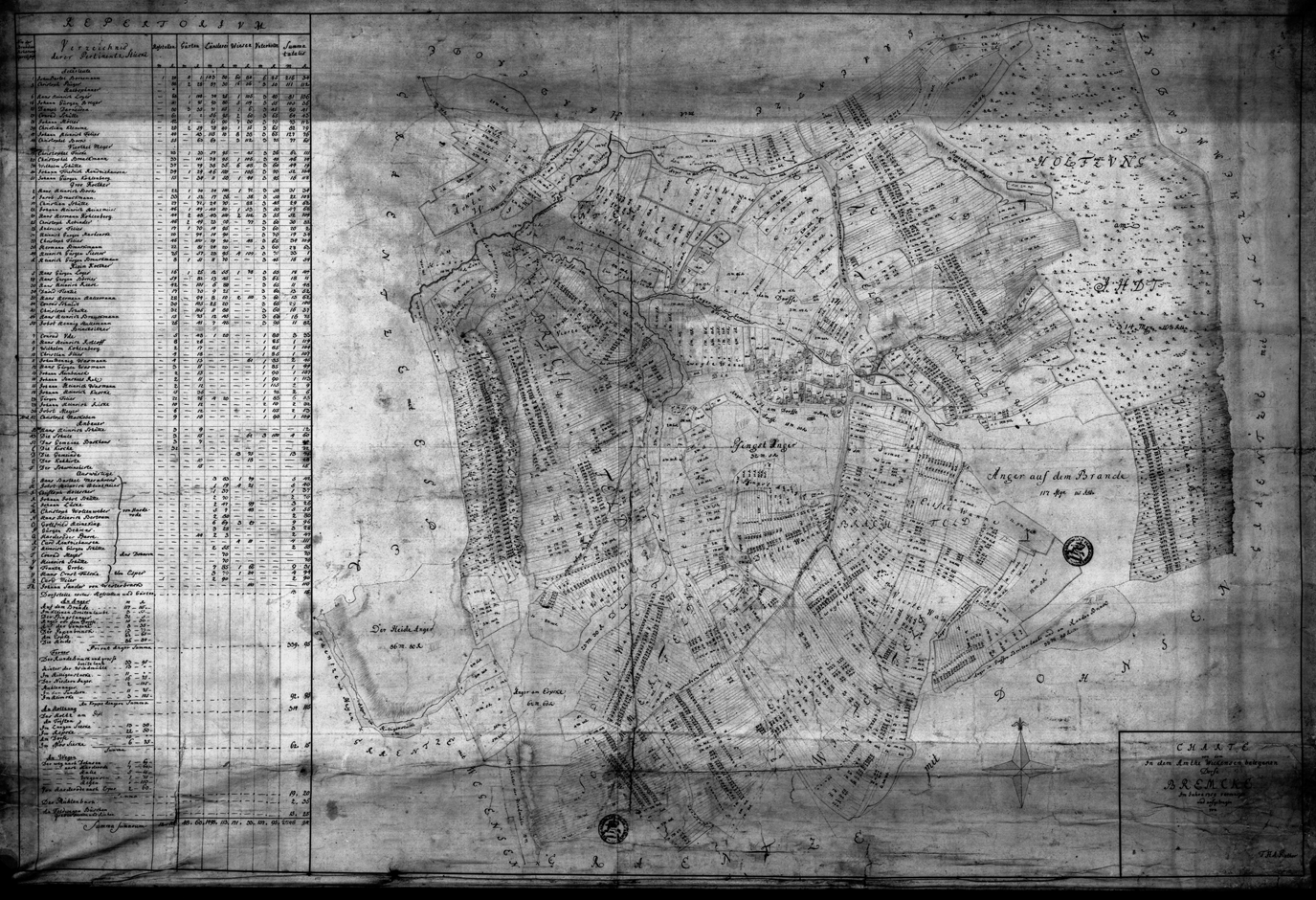
The source material of the land survey, which had to be inserted into the HGIS, consists of two complexes: first, the historical map material, and second, the serial sources. The factual data is taken from the village, field and meadow descriptions and refers to individual landownership (plots of land and agrarian land, differentiated according to the ways in which they were used), the type and numbers of productive livestock, the feudal and princely duties and services and sometimes also the condition of the buildings and the head of the household's occupation.Footnote 19 In addition, the socio-economic, natural and geographic features of the entire municipality were documented, as were ecclesiastical data, constitutional rights and rights of disposition. The information is grouped according to fixed categories representing a preliminary type of form, and these are summarized in tabular format at the end of the description. The range of data collected in the land survey far exceeds the scope of the information contained in the older tax register; this can only be explained in the context of how the information presented related to the intentions of the political regime.Footnote 20 This land survey therefore represents the most complete source available for the eighteenth century, as it allows a territorial reconstruction of the socio-economic constitution of every site on the basis of every individual household. The cartographic sources of the Brunswick Land Survey are as dense with information as the village, field and meadow descriptions. The 432 cadastral maps passed down to the Wolfenbüttel Regional Archive are drawn to a scale of approximately 1:4,000 and, depending on the surface area of the illustrated communal district, are up to four square metres in size (Figure 1). These maps show the land areas and boundaries of all house and farm plots and garden parcels, as well as the agricultural areas, differentiated according to whether they were used as forest, pasture, meadow or farmland. Over the top of these, they illustrate the ground plots of buildings (main and annex buildings), pathways – including paths across fields – standing water and waterways, terrain profiles (indicated by cross-hatch) and the occurrence of raw materials. The maps likewise illustrate how the agricultural land was organized, provide the names of open fields and document how strips of land and open fields were allocated.Footnote 21 The maps’ other components are a tabular summary of the municipality's inhabitants and the land they owned, an arrow pointing north, a scale bar and map cartouches (decorated in various ways according to the artistic skills of the draughtsman) in which information such as the title of the map, the year of the survey and the name of the land surveyor is set out.
Cadastral map of the village Bremke 1759, from F.A. Penther (NLA-WO K 5602)

Regular use of the original rolled maps as soon as they were produced caused some significant damage (see Figure 1). Aside from some damage caused by damp, and areas that have been rubbed off, there are horizontal and vertical tears on the upper layer of the maps, which has led to the loss of information from some small sections of the maps. Furthermore, the texts – in particular the coloured numberings of the parcels of land – are often difficult to read. This is why copies of the originals were produced from the 1790s onwards. The copies for the municipalities in the investigation area were produced in the first half of the nineteenth century.
Why analyse the data from the Brunswick Land Survey using a GIS? The two sources – the historical map and the serial register – represent, in an ideal-typical manner, the two basic forms of the data structure of a GIS: spatial and factual data. The cadastral maps are an extremely detailed source of spatial data, describing in small sections, and to the level of a geodetically exact reproduction, the spatial structure of individual settlements in the eighteenth century. The village, field and meadow descriptions constitute one of the most extensive and differentiated surviving register sources, allowing profound insight into the socio-economic conditions and the situation regarding property rights within these settlements. The decisive criterion, however, is the possibility of correlating the two data complexes – a rare opportunity, considering the conditions under which early modern written records were passed down. In 1753, the principality of Brunswick-Wolfenbüttel introduced a fire insurance scheme which entailed a comprehensive numbering of all homesteads and farmsteads. This numbering was adopted in the surveys carried out after 1753. In general, not only the parcels of land on the sites but also the communal district plots are identified by their fire insurance numbers.Footnote 22 On this basis, the historical spatial data can be combined as required with the serial data in the registers in order to produce thematic economic and social topographies.
Digitization of data permits the integration of two sources within a single HGIS. For this reason, the information from the village, field and meadow descriptions, as well as from additional sources,Footnote 23 was summarized in database tables, and the cadastral maps were digitized. The map digitization is based on negative slides of maps in the format 13 x 18 cm that were prepared as part of the production of backup films at the Wolfenbüttel Regional Archive. These black and white photographs were digitized as greyscale scanner. Images with resolutions of up to 3,000 dpi were obtained, and these images were subsequently partially reworked. The high resolution was necessary because the details in the digital images had to be identified in the millimetre range (numberings, inscriptions, parcel boundaries). Subsequently, the cadastral maps were georeferenced on the basis of the ‘Historical Map of the Territory of Brunswick in the Eighteenth Century’.Footnote 24 This cartography is a redrawing of the cadastral maps of the land survey to the scale of the current topographical map (1:25,000), in which – because of the reduced scale – all the details of the cadastral maps (approx. 1,000) were lost. Because this redrawing uses the map sheet division of the topographical map, the historical map could be georeferenced by transferring the Gauß-Krüger co-ordinates from the map sheet division corners of the topographical map into the map sheet division corners of the historical map. Then, the corresponding ground control points – these could be prominent corner sites on the boundary of the communal district, or the position of church spires on the site – were identified, and their co-ordinates transferred to the cadastral maps using the georeferencing function of the GIS software.Footnote 25 The fact that the cadastral maps – which have been oriented towards north using a compass – incline approximately 10 to 15 degrees to the west in relation to the historical/topographical map is due to magnetic declination in the mid-eighteenth century.Footnote 26
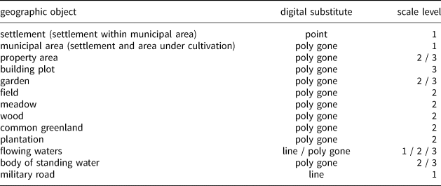
The next step was to digitalize the geographic objects (i.e. the sub-areas and landscape elements) to be taken from the maps. The following object model is shown in Table 1.Footnote 27 Three scale levels are planned for the derivation of the thematic topographic maps: (1) the overall investigation area; (2) the site plus the communal district; (3) the site on its own. This still leaves the possibility of adding further categories to the open object model. The work undertaken thus far has involved the digitization of just under 8,100 items.
Object model HGIS Weser district

scale level 1: investigation area (Weser district), approx. 1:120,000
scale level 2: municipal area, approx. 1:4,000 to 1:12,000
scale level 3: settlement, approx. 1:2,000 to 1:3,500
Transitions between urban and rural spatial structure
The Brunswick Weser district is particularly suited to a comparison of settlement histories because it contains urban, semi-urban and rural settlements within a very small area, and because its peripheral position relative to established transportation routes means the spatial structures, which had grown gradually and in small sections, were probably subject to no more than moderate reshaping. The aim of the comparison (structured as an empirical regional study) is to question the clear separation between urban and rural space that is assumed to have existed in the early modern period, and to expound empirically the term ‘fluid transitions’ between town and country. This term is used in the research literature and refers in particular to social, economic and spatio-structural conditions.Footnote 28
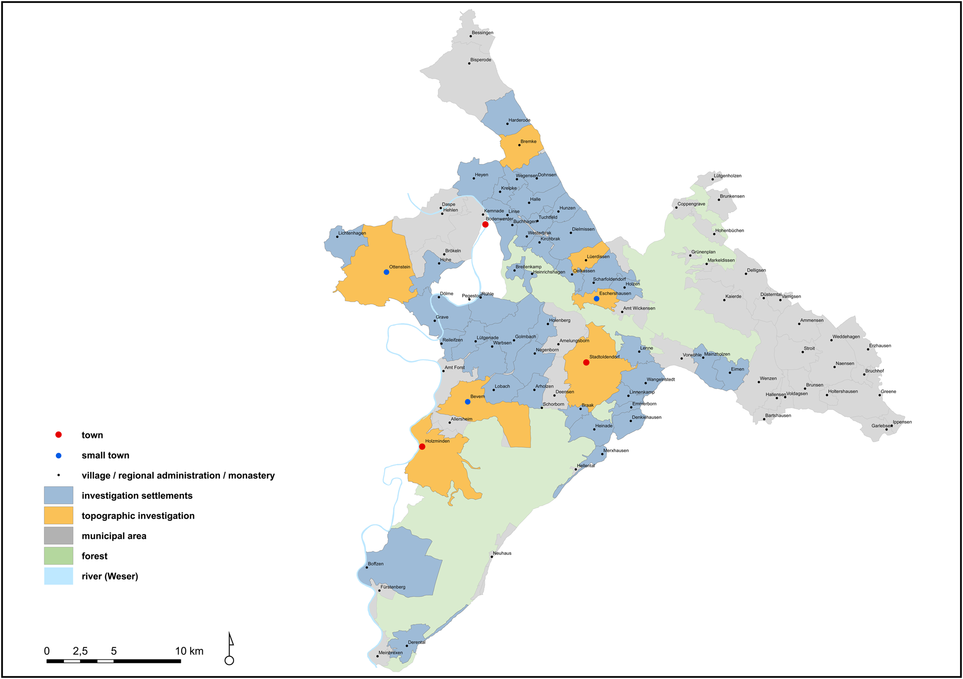
The serial data from the sources mentioned above for a total of 51 sites of investigation form the empirical basis of the comparison. These sites consist of two towns (Holzminden, Stadtoldendorf), three semi-urban small-town settlements (Bevern, Eschershausen, Ottenstein) as well as 46 village settlements. A more detailed socio-topographic investigation was undertaken for the town and small-town settlements as well as for two selected village settlements (Bremke, Lüerdissen) (Figure 2). The typological arrangement of the settlements in the area investigated reflects the terminology used in the source materials. Thus, the examples of urban settlements referred to are described as ‘towns’ (‘Städte’), ‘small towns’ (‘kleine Städte’), ‘Weser towns’ (‘Weserstädte’, such as Holzminden, which is situated next to the River Weser) or ‘rural towns’ (‘Landstädte’). Smaller, less populous locations such as Bevern, Eschershausen and Ottenstein are referred to as semi-urban small-town settlements (‘Flecken’).Footnote 29 Holzminden and Stadtoldendorf can be seen as settlements that fit perfectly in the dense pattern of small towns that has typified urban development in Germany since the late Middle Ages.Footnote 30 In German research literature, urban settlements with fewer than 2,000 inhabitants are referred to as ‘small towns’ (‘Kleinstädte’);Footnote 31 however, it should be remembered that in other regions of Europe, definitions of this kind have in the past been based on slightly different criteria.Footnote 32 Efforts to define ‘small towns’ in terms of quantitative criteria such as population sizes have time and again run into the problem that the setting of upper and lower limits to distinguish ‘small towns’ from ‘medium-sized towns’ at the top end of the population scale, and from semi-urban village settlements at the bottom end, takes little account of the existence of diverse conditions at the regional level, particularly when the regions concerned are viewed from a broader European perspective. Quantitative characteristics of this kind have not been used therefore as distinguishing criteria, nor has any effort been made – widespread though the practice may be – to draw distinctions between urban and/or non-urban settlements based on the varying political, social, economic and cultural functions of the respective settlements. Instead, the focus in the following discussion will be on a comparison of the socio-topographical spatial structures at individual locations, insofar as these are representative of the transitional area between urban and rural settlement.
Brunswick Weser district mid-eighteenth century: settlements of Investigation

Selected aspects of the GIS-based analysis which emphasize the transitional forms in the spatial structures of the three settlement segments are now considered: first, the general morphology of settlements; second, the various forms of settlement growth; and finally, the spatial structure of open fields and communal districts, as demonstrated by specific examples of how agricultural cultivation was organized (open-field systems), and by municipality boundaries.
Settlement morphology
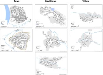
A morphological sequence of all the topographically investigated examples of settlements from the town (left), through the semi-urban small towns (middle), to the two villages (right) is shown (Figure 3). The illustration shows the sites with parcels of land, the ground plots of buildings, the garden plots partially adjoining these at the periphery and waterways. The towns are spatially enclosed sites (either round or oval in basic shape), within which rectangular blocks of buildings and parcels of land have developed (chequerboard pattern). In the case of Holzminden, the external boundary of the settlement site is formed by the river and the densely built-up parcel ring of land that encloses the whole site; in the case of Stadtoldendorf, it is formed by a town wall. Closed building lines have developed on the external sides of the blocks of buildings, and there is a tendency towards a linear, rectangular road network connecting the town gates with one another.
Settlement topography: town, small town, village

The semi-urban settlements in the sequence of adjoining forms on the left indicate that certain elements of the urban morphology are repeated. However, the ground plans of buildings throughout the site and the shapes of individual parcels of land, as well as the density of general development and the formation of blocks of buildings around courtyards, can be seen to be less rigorously homogeneous. The ground plan of the small town of Ottenstein (top middle row) has a striking structure: it consists of two districts divided by a large tithe house. Whereas the south-eastern area of the settlement possesses a distinctly urban character, with buildings arranged closely together and facing the street (together with long, rectangular parcels of land), the north-western part of the town has more of the character of a village, with predominantly amorphously shaped plots of land, and buildings arranged in an irregular way upon these. This amorphous, heterogeneous and fragmented mixture of plots and buildings also characterizes the ground plans of the two village settlements on the right-hand side of the sequence, with the example at the top (Bremke) showing a settlement site centred on a village green.
The village meadow tended to be a large undeveloped area that was usually centrally located. On the outskirts of a village, or at its very centre, there would generally be a church adjoined by a cemetery. The meadow was used as pastureland for animals, and in the course of the development of village sites, particularly in the fifteenth and sixteenth centuries, it tended to be used by groups that had come to settle in the village in the fairly recent past. It is clear from the ground plots (some of them are very small) and the marginal – or wholly absent – parcels of land around these buildings that spatial resources were very limited.
The morphology sequence illustrated above exemplifies an almost ideal-typical gradation of spatial structure from the provincial to the semi-urban to the village settlement. Here, it becomes clear that the complex of parcels of land and the close arrangement of buildings, the formation of blocks of buildings, as well as the development of transport routes and public thoroughfares, represent the village gradually assuming the character of a town, with the differentiation between spatial elements becoming more geometrical and linear. As a rule, the development of the spatial structure within a settlement was subject to a constant process of change which, in the long term, was significantly influenced by demographic cycles. In addition to the farming of meadow land in the villages, other forms of settlement expansion can be identified in the land survey maps.
Settlement growth and its economic basis
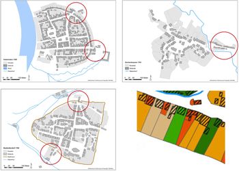
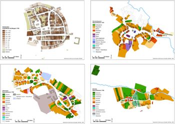
In the investigation area, the depopulation caused by the calamitous events of the seventeenth century had already been more or less reversed by the beginning of the eighteenth century. Over the course of the century – particularly from 1750 – the population increased significantly, and we can see settlement growth beginning to take shape on the land survey maps.Footnote 33 This population growth prepared the way for the extensive reshaping of early modern spatial structures that took place in the nineteenth and twentieth centuries. There are thus clear signs of expansion in the towns that are the focus of this study, and, for the first time, we can see the enclosed site of a settlement being opened up, and new settlement space being developed. This process is discernible in the new buildings that appear along the main transportation routes, close to the town gates (Figure 4, circle). Semi-urban settlements underwent a similar, but significantly more intensive, phase of development (Figure 4, top right of the map).Footnote 34 Primarily in Eschershausen and Bevern, almost closed rows of buildings emerged on both sides of the western arterial road. These are striking because their ground plots and parcels of land belonging to the buildings are smaller than the ones in central locations. In addition to this form of external settlement expansion, the map source also shows internal growth in terms of settlement aggregation (map section bottom right). The map section of the site of the small town of Bevern marks the farmers’ peasant-class affiliations in different colours. The plots marked in red represent what are known as ‘Brinksitzer’, or settlers arrived beginning in the fifteenth century and who were allocated small plots on the plots of the middle and upper peasant classes. Some of these were no larger than the ground plot of the main building on the landholding.
Settlement growth I

Once the homesteads and farmsteads which had been abandoned in the seventeenth century were occupied again, the subsequent population growth triggered the next settlement phase (the arrival of what were called the ‘growers’). The plots belonging to this group are marked in yellow on the maps (Figure 5). On the western periphery of the small town of Eschershausen (Figure 5, top right) the plots of the ‘growers’ directly adjoin the plots of the Brinksitzer (likewise in a linear row following the street).
Settlement growth II

In addition to the forms of internal settlement aggregation seen in the sixteenth- and seventeenth-century village settlements already mentioned, meadow farming also took place in the village of Bremke (Figure 6, bottom right). Here, the larger open areas at the centre of the site, generally used as pastureland (meadow), were colonized by Brinksitzer (parcel colour: red). Because they had arable land at their disposal, the work of households of the older settler classes was often mainly agricultural; the groups of settlers who arrived later (such as Brinksitzer and ‘growers’), on the other hand, were reliant on commercial work or a daily wage. Because the available arable land (particularly cropland) had already been divided, the only option that remained for the later settlers was to operate a small horticultural enterprise and/or, if the municipality allowed it, to keep a herd of cattle on the municipality's pasture land. Despite the fact that these farmsteads and homesteads lacked agricultural land when they were first built, there is some evidence of peripheral landownership. In the mid-eighteenth century, there seems to have been a tendency, even for these less affluent social groups, to develop or extend the agricultural and horticultural components of their incomes, regardless of whether they had settled in an urban or rural municipality.
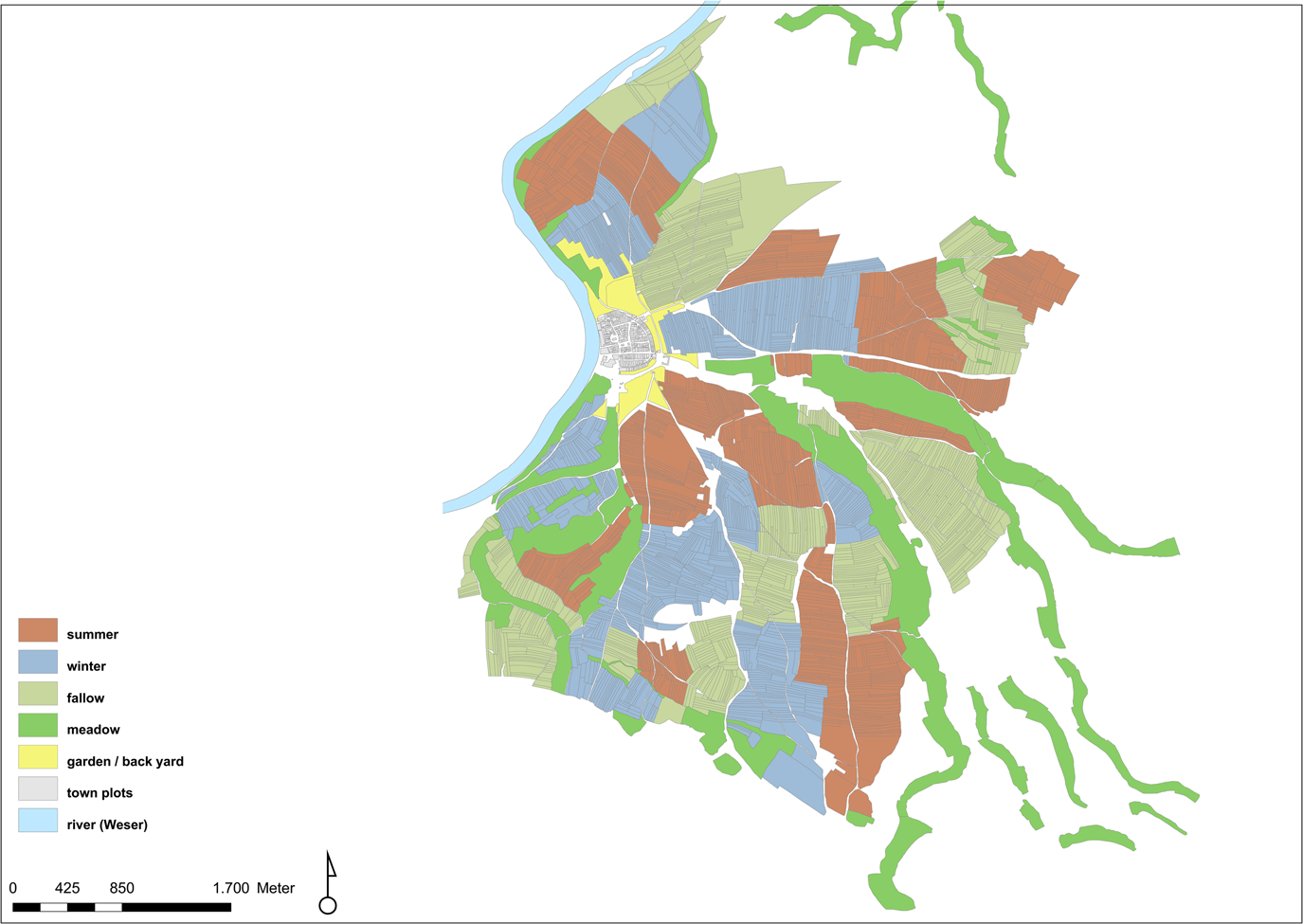
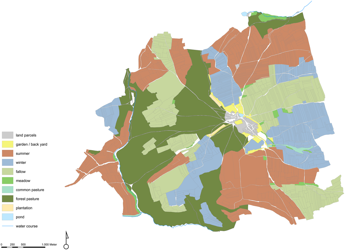
Holzminden 1765: three-field crop rotation

The most important trade in the area of investigation was the production of cheap canvas for export overseas (Spain, Portugal). This trade was, to a greater or lesser extent, practised intensively by the majority of households in the Weser district. Canvas production was the main source of income for many of the most recently arrived settlers who were of a low social status. No classic proto-industry developed, but there is evidence of individual actors organizing parts of the production chain, and also of the trade in both primary products and end products on a regional scale. As well as the beginnings of centrally managed production and distribution operations, there were also forms of individual or collective purchasing and distribution activities that involved local producers purchasing the primary products and distributing the canvas themselves.Footnote 35
Canvas production was not only deeply embedded in the regional economy of the Weser district: it was of such great economic importance to the principality as a whole that the central administration waived the requirement (otherwise obligatory) that linen weavers in the countryside be members of a municipal guild. In the Weser district, there was a kind of territorial division of labour which took much of the heat out of the usual disputes between town-based linen weavers, who were generally organized within guilds, and the free weavers in the countryside. The weavers in the towns concentrated on the production of higher-quality materials, while the country weavers restricted themselves exclusively to the production of lower-value export goods. The towns also experimented with new forms of business by setting up factories.Footnote 36 In periods when demand for export linen of lesser quality was high, urban weavers, too, may have opted to serve this lower end of the market, especially if sales of high-quality materials were declining (low demand, changing fashions). Economic integration at the supra-regional level thus gradually dissolved the distinction between urban and rural trade that was characteristic of early modern town–country relations (and as evidenced by the linen production in the Weser district).Footnote 37 This form of early modern trade began to dissolve the guild-regulated norm within urban economic autonomy, and in so doing it gave rise to spatial relations which promoted the integration of urban and rural economies in new regional units.
Spatial structure of the agriculture
Agricultural and horticultural activities were generally an integral part of the early modern social and economic fabric, irrespective of whether the households engaged in these activities were located in a town, in a semi-urban settlement or in a village. The farming activities undertaken in most rural settlements were one of the most important elements of the communal economic life of many urban and, in particular, provincial settlements. As yet, however, little has come to light about the spatial structure and the patterns of cultivation of agriculture in medieval and early modern towns.Footnote 38 The possibility of a small-section reconstruction of an urban open field around one hundred years before the open-field consolidations of the nineteenth century is therefore particularly welcome. The many different aspects of a GIS-based open-field evaluation are confined here to a comparative explanation of the similarities and differences between urban and rural agriculture.Footnote 39
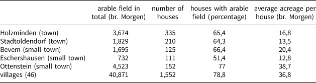
Before outlining the spatial characteristics of the cultivation system using the open-field map, it is helpful to compare the basic data available for the agricultural land in the three settlement segments. For the 51 areas of investigation in the Weser district, land data is available for, in total, 2,485 households. Table 2 – which provides an overview of arable land per homestead, town, small town and village – shows that in each town (Holzminden, Stadtoldendorf), approximately 65 per cent of the households had agricultural land at their disposal for cultivating grain, whereas in the semi-urban settlements (Bevern, Eschershausen, Ottenstein), this figure varied between 51 and 77 per cent.Footnote 40 In the 46 village settlements, on average 79 per cent of the households owned arable land. The high number of agriculturally active households in the town examples is striking; however, the figures for the semi-urban small-town settlements also show that the distinction between urban and rural settlements is often blurred. In principle, crop cultivation in northern Germany followed a three-field crop rotation cycle (summer field, winter field and fallow field), and this was also the case in Holzminden (Figure 6). Each of the three open fields (summer grain, winter grain and fallow land) consisted of several sub-areas that formed a fragmented mix of cultivation units. The development of this field structure can be explained, on the one hand, by the integration of open fields from abandoned settlements in the immediate vicinity of the town of Holzminden; this integration process took place mainly in the late Middle Ages. But the spatial division of the open fields may also have been in response to the inconsistent quality and composition of the soil. The terrain rises significantly at the western edge of the open fields and leads onto the forested slopes of the Weser Uplands (Solling). The soil quality is particularly bad in these peripheral areas, and the land was under permanent threat of erosion.
Acreage: town, small town, village

1 br. Morgen = 2501,5 m2
Source: März, Fließende Übergänge, 385.
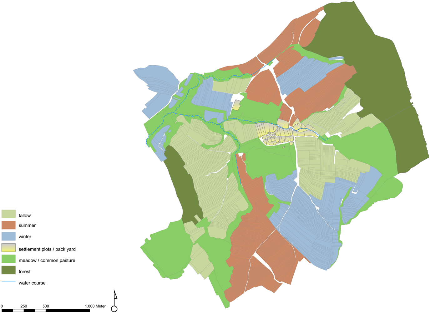
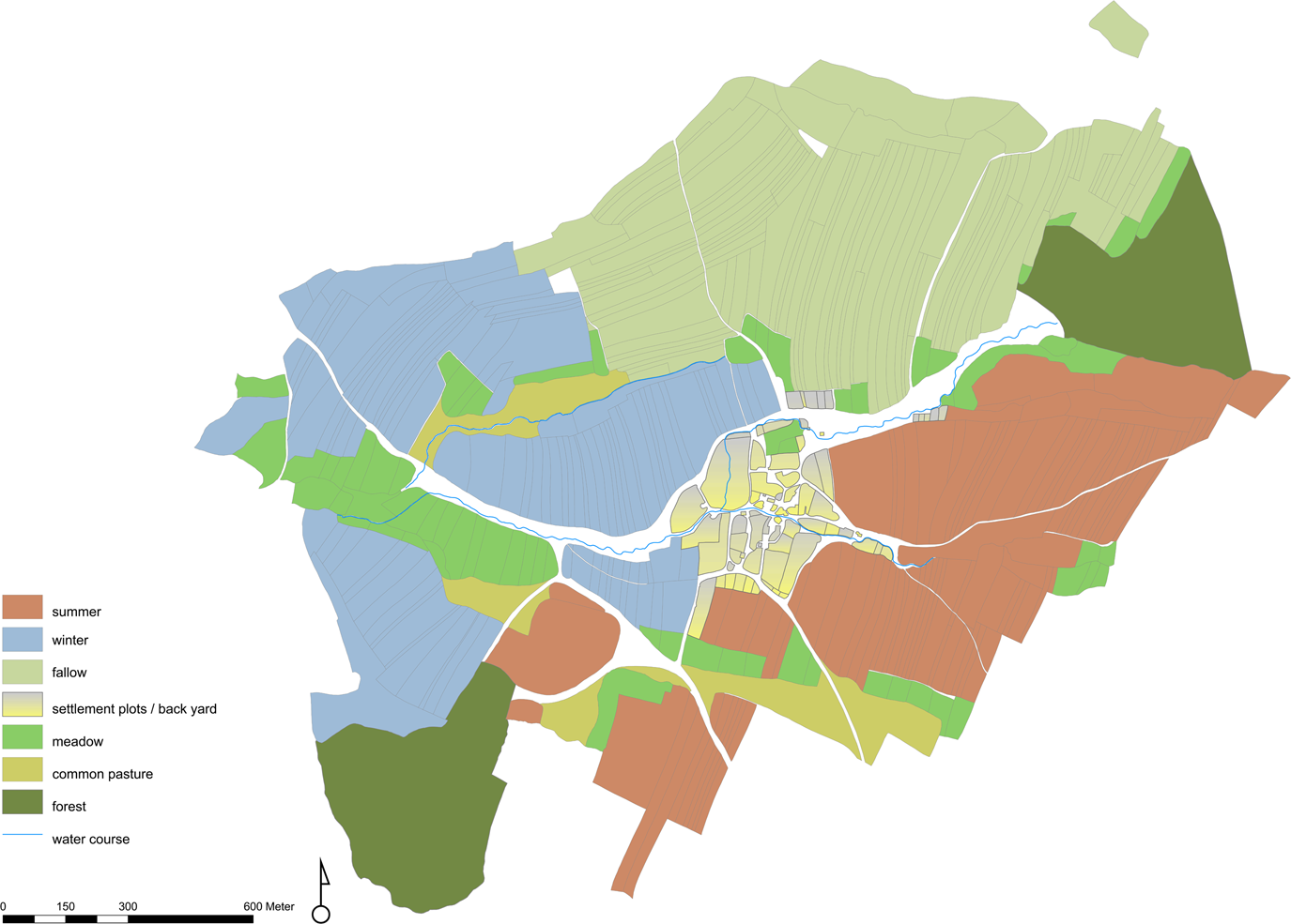
If we now look at the open-field system of the small town of Ottenstein (Figure 7), as well as the open-field systems of the village settlements Bremke and Lüerdissen (Figures 8 and 9), we can see – depending on the overall size of the open field – a gradual decrease in the complexity of the sub-areas. Whereas the individual open fields in Ottenstein and Bremke still consist of sub-areas, in the smallest location, Lüerdissen, they are ultimately grouped into three highly typical, almost equally sized areas around the site. The comparison of the open-field system very clearly shows not only a consistent cultivation system but also incremental gradations in the complexity of the system's spatial structure.
Ottenstein 1760: three-field crop rotation

Bremke 1759: three-field crop rotation

Lüerdissen 1760: three-field crop rotation

Finally, let us briefly consider the problem of boundary demarcation in the rural economic area. The Brunswick Land Survey provides clear evidence of widespread communal third-party ownership of agrarian land. The open-field maps indicate individual inhabitants living in one municipality owning land in neighbouring municipalities. This finding applies to all the open fields investigated, and possibly points to a general lack of agricultural land in the eighteenth century. When individual farmers who were looking to increase their private property found no more arable land available in the municipality to which they belonged, they would often try to acquire land from the neighbouring municipality – land that was as close as possible to their own farmstead. This explains the peripheral location of the newly acquired land. Another reason for this phenomenon could be that, in cases of inheritance, the sections of arable land belonging to a family unit that were located on one side of the border between two municipalities might have been transferred over the border, and the heirs living on the other side of the border would then have established a new farmstead in the neighbouring municipality.
Often, these plots offered less attractive, marginal agricultural land, which was much in demand among the social groups that settled later. In addition to this spatial integration of private agricultural land beyond the border of a municipality, it was common for neighbouring municipalities to keep enclosures. These were pasturelands that straddled the border between two municipalities, and that were used by the inhabitants of both municipalities. However, the status of such tracts of land was often ambiguous in terms of legal ownership, and in many cases, this led to border conflicts later on in the nineteenth century when legal proceedings were instituted to divide up the land. The arable fields of Holzminden exemplify a particular form of spatio-structural integration of town and country (Figure 10).Footnote 41 Approximately one kilometre south-east of the town, the village settlement of Altendorf was integrated as an enclave in the urban open fields. The agricultural land of the village consisted of a fairly extensive, enclosed complex of fields on the northern periphery of Holzminden's open fields (not visible on the map) as well as of strips of land (represented in orange in the illustration) that were mixed in with the parcels belonging to the citizens of Holzminden. The spatial complexity of this distribution of land highlights the problems presented by the prevalent patterns of cultivation. The practice of crop rotation required regular consultation with the towns’ inhabitants, and the more remote parts of the fields could only be reached via long access routes and with the permission of the citizens of Holzminden.
The village Altendorf within the open field of Holzminden

Again, there is no clear demarcation of boundaries here; rather, we see forms of spatio-economic and communal integration based on long-lasting, socio-economically induced diffusion processes.
Conclusion
HGIS can be effective tools in the reconstruction of historical spatial structures. Their use, however, requires the source information to offer the possibility of either a direct or indirect spatial reference, and they are only wholly efficient when they are used to analyse mass data. Their strength lies in bringing together data from different temporal layers onto a platform on a lasting basis, and in diachronically representing or visualizing spatial processes. Furthermore, it is possible, after making the appropriate adaptation, to correlate data from very different sources.
The use of a GIS in the present study is justified by the availability of an unusually detailed eighteenth-century source which allows the correlation of large-scale spatial data (open-field maps) with comprehensive sets of factual data. Furthermore, the structural situation of the settlements in the area of investigation enables the development of a synchronic spatial comparison of urban, semi-urban and rural settlements.
Aspects of the town–country spatial comparison presented here develop only one part of the analytical spectrum facilitated by HGIS. A comprehensive study of the micro-structural forms of transition between town and country in the Brunswick Weser district has identified endogenous, exogenous and morphogenetic spatio-structural factors in the dissolution of boundaries between eighteenth-century urban and rural settlement.Footnote 42 The early modern household and community, with its heterogeneous occupational and income structures (agriculture, horticulture, skilled trades and crafts, commerce) as well as its flexible approach to new income options, was the central endogenous factor. This form of economic community was independent of the settlement and the living environment and increasingly became the norm in domestic reproduction. A further factor to be considered is the finding that often the households whose economic positions were most precarious were those most actively engaged in improving the agricultural and horticultural elements of their incomes in the second half of the eighteenth century.Footnote 43
Economic conditions in the agricultural sector in the final three decades of the eighteenth century did not, however, lead to further commercialization of farmers’ activities. Standing in the way of such a development was the general shortage and poor quality of usable farming land and the fragmentation of the ownership of open fields. Only the largest farms managed to harvest crops in quantities that allowed them to bring produce to market after having satisfied their own needs. Furthermore, reconciling the many and varying interests of the individual landowners hindered the co-ordination of resources required for the efficient cultivation of different crops, and even contemporary reports testify to the loss of farmland that resulted from drawing borders between parcels of land. The thematic agricultural maps of the Weser district HGIS thus show that in terms of their genesis and organization, there was precious little difference between the open field systems that existed in urban, semi-urban and rural settlements. The parcels of land worked by subsistence farmers throughout the area investigated, and especially the vicinity of towns, were often so small that the farming activities of individual smallholders was scarcely commercially viable. It seems more likely that full-time farmers were allowed to participate in the working and management of these micro-holdings, and that the actual parcel owners enjoyed only a part of the proceeds from the farming activities. Even so, there was a general interest from the inhabitants of the Weser district to acquire arable land or (at the very least) further parcels of gardening land. In pursuing these acquisition goals, they were minimizing economic risk by diversifying their sources of income.
The Brunswick Land Survey maps clearly illustrate the anachronistic spatial fragmentation structures of a farming system that developed over a long period, and which continued until the threshold of modern agriculture. The origins of the system that existed in the principality of Brunswick-Wolfenbüttel can be traced to the Middle Ages. Although the logic underlying the development of this system is often difficult to interpret, it seems safe to say that the system of farming studied was determined by pre-modern production conditions, including various kinds of manorial systems, generational land transference, technical developments, accessibility of markets, and environmental factors.Footnote 44 The precondition for achieving a structural transformation in the agricultural sector would have been a thoroughgoing consolidation of the land, which was what the Brunswickian government had in mind with its land survey. However, the merging of sub-areas into larger units of land failed because of the extreme complexity of the systems of open fields and the resulting conflicts between landholders. It was not until the land consolidations and the abolition of feudal levies that were decreed in the nineteenth century that sizeable increases in production volumes and the sustainable modernization and commercialization of agriculture was possible.Footnote 45
Exogenous factors such as increasing production for inter-regional and global markets were closely connected with the endogenous conditions in the eighteenth century. The town–country nexus played an increasingly important role in the progressively more intensive and concentrated trade relationships, as exemplified by the production of linen cloth. The government of Brunswick gave additional stimulus to this market by promoting competition between urban and rural commerce; this was particularly beneficial to textile export production. A further important exogenous factor was population growth, which changed the spatial structures of nearly all the sites within the investigation area, irrespective of which settlement segment they belonged to. However, there are indications that the small-town settlements were the most attractive to settlers.
Finally, there were enduring morphogenetic spatio-structural factors characterized by processes of growth, contraction and abandonment. These processes remained active for centuries, manifesting themselves in a history of shared and changing ownership within the functional areas of each individual settlement. The results of the comparison show, on the one hand, structural homology (open fields), and, on the other hand, forms of a gradual transition related to the constraints and density of the sub-area structure (site).
The existence of an intensive town–country nexus of the kind that was so characteristic of the process of urbanization in the early modern period can safely be assumed where evidence for such a nexus is available. This evidence might take the form of proof of the existence within an urban setting of a typically rural institution, such as a highly developed open-field system. Alternatively, it may be population growth of a kind that can be seen to have brought about comparable patterns of spatial utilization in both urban and rural settlements. Or it may be the proven existence of a proto-industrial export trade in which an entire urban area was as intensively involved as the surrounding countryside. The socio-economic processes that took place in the nineteenth century were quantitatively and qualitatively more far reaching than those of the preceding century. And it was the towns, in particular, that profited from them.
An HGIS is the most suitable instrument for maximizing the full potential of the Brunswick Land Survey, particularly on account of its ability to capture and illustrate the diverse aspects of the complex socio-economic structures that existed within the given spatial context. The accuracy of the serial data corresponds with the accuracy of the map data, which is unusual for eighteenth-century sources. The information acquired from historical maps seamlessly assimilates the instrumental functionality of a GIS, which indicates a clear demarcation of the geographic spatial elements. The extremely detailed serial and cartographic data provide comprehensive insight into the social and economic micro-structure of the regional settlement societies. The combination of this structural method (HGIS) with the traditional standard analysis of administrative and narrative sources introduces an entirely new depth to socio-economic analysis of the investigated settlements, including the spatial relationships within them. It is now possible to address research questions arising out of the more general historiographical context. The research methods that this combination of methods enables will allow for a level of analysis linked to a more fully inclusive ‘spatial history/humanities’ concept.Footnote 46
The application of digital tools (GIS; network analysis) is particularly worthwhile when researching historic towns, which, compared to rural spaces, are composed of relatively assessable and cohesive dense spatial units. This in turn allows for a more comprehensive classification of spatially relevant sources. The heterogeneity of these sources (written spatial descriptions, graphic artwork, cityscapes, geodesic cartography) facilitates a strategy of ‘deep mapping’ – an epistemological and methodological concept that facilitates both the diachronic and synchronic investigation of historical place and space through the combination and conflation of different media and source data in a spatial database (GIS).Footnote 47 A deep map is an open system or environment that integrates new data and formats and, in so doing, enables a high degree of user participation.Footnote 48 Such a map facilitates not only the marshalling of factual and numerical data but also the evaluation of historical and contemporary views and narratives, even if these are of a highly individual and subjective nature. The researcher thus has to hand a tool that facilitates the production and negotiation of new space narratives.Footnote 49
One of the practical challenges confronting the historian is the sorting of disparate, heterogeneous and often unspecific source data in such a way that these data can be incorporated in a meaningful way in a GIS database. This complex task – which involves the critical sifting and transcription of source materials – frequently raises the problem of having to graft source materials and data with no spatial reference indicators on to a Cartesian reference system in the form of a geo-database. Co-ordinates can be identified in a number of ways: for example, through the georeferencing of buildings, parcels of land or addresses, or through deductions based on what is known about where specific persons, or groups of people, resided, worked or spent time. However, this approach seldom makes it possible to match the kind of detailed data mentioned above with complex environmental or structural information. Would this method, for example, permit the simulation of the influence of the political institutions in an early modern state? Would it provide insights into how such institutions could have affected the constitution and character of a deep-mapped area over a period of time? Along with the generation of new kinds of digitized spatial data, two of the main tasks currently confronting the spatial humanities are devising ways of modelling and correlating disparate data formats and achieving further progress in the field of systematic spatial hermeneutics.
The Weser region that forms the subject of the present HGIS study could be included in a deep map project investigating the historical causes of the structural and economic deficits currently observable in parts of southern Lower Saxony. However, a deep map project of this kind would have to be problem oriented and embedded equally in scientific and public discussions. But the openness of the deep map approach and the multiplicity of perspectives that it allows would provide a way of viewing historical spatio-temporal structures from an unusual angle as well as, at the very least, an impetus for a critical dialogue about existing historiographical paradigms. It is important to continue to develop historical data infrastructures so that future quantitative comparisons can be conducted using various thematic and spatial investigation scales, and to do so from a diachronic perspective.Footnote 50
Supplementary material
The supplementary material for this article can be found at https://doi.org/10.1017/S096392682000022X.