Lowland Maya (Figure 1) polities of the Classic epoch (a.d. 250–1000) were normally ruled by monarchs with the title of ’ajaw (“lord”) or, beginning late in the Early Classic period (a.d. 250–600), k'uhul ’ajaw (“holy lord”). In hieroglyphic inscriptions, kings are attributed so-called “emblem glyphs,” personal titles that identify them as the holy lords of named dynasties rather than of fixed locations (Berlin Reference Berlin1958; Mathews and Justeson Reference Mathews, Justeson, Justeson and Campbell1984; Stuart and Houston Reference Stuart and Houston1994:6–7). The greatest diversity of such dynastic names in the hieroglyphic corpus appears during the eighth century—a time when lowland populations were at their peak, when sub-royal noble titles proliferated in the inscriptions, and when non-ruling members of royal families also used the k'uhul ’ajaw title (Houston Reference Houston2012:167; Jackson Reference Jackson2013:82–86).
Such an abundance of different dynasties, each claiming royal status, can be interpreted in two ways. First, the abundance of dynasties reflect the disintegration of formerly territorially extensive kingdoms, with subordinate nobles rebelling or demanding recognition as k'uhul ’ajaw in exchange for continued loyalty. The weakening of royal power relative to the aristocracy prefigures nobles’ revolts of the kind proposed as explanations for the early ninth-century collapse of some royal courts (e.g., Fash Reference Fash1983:287, 2005:98–2001; Houston and Stuart Reference Houston, Stuart, Inomata and Houston2001:76). The other interpretation is that they are textual correlates of a geopolitical strategy whereby ambitious kings raised vassals to royal status and sent them to govern newly acquired or tenuously held territories. Both models describe real processes that unfolded in different times and places. Archaeological data and careful attention to the historical contents of epigraphic inscriptions are necessary to distinguish which operated in any particular case.
This paper investigates one such case: that of the northwestern Maya Mountains of southwestern Petén, Guatemala, a region where multiple royal dynasties were established in the Late Classic period (a.d. 600–830). Archaeological and epigraphic data suggest that the political landscape of the region was shaped by cooperation and conflict between local rulers and potentates from outside it. One strategy they employed was the creation of nominally independent royal courts whose kings owed their positions to overlords. This strategy reproduced on a smaller scale the long-distance machinations of Maya hegemons like Tikal and Calakmul, pointing to the practical and ideological limitations of Maya kingship as an administrative institution.
CLASSIC MAYA STATECRAFT
Controversies over the nature, size, and number of Classic Maya polities (see Sharer and Golden Reference Sharer, Golden, Golden and Borgstede2004 for an overview) have largely been superseded by culturally and historically specific studies of how Maya courts worked (e.g., Inomata and Houston Reference Inomata and Stephen D.2001; Jackson Reference Jackson2013) and how they interacted over time (e.g., Martin and Grube Reference Martin and Grube2008). By the end of the Late Classic period, there were dozens of nominally independent lowland Maya kingdoms, each with its own k'uhul ’ajaw. Below the holy kings were other lords with a variety of hereditary and royally-bestowed claims and titles. Some governed subject centers, while others served as attendants in central courts (Houston and Inomata Reference Houston and Inomata2009:166–167; Jackson and Stuart Reference Jackson and Stuart2001:222–226). Particularly in the Usumacinta River region, governors called sajal, who administered towns and territories on behalf of kings, are celebrated in monumental texts and portraits. Yet those same sources suggest that their status was variable: the kings of Yaxchilan exercised tighter control over their sajal vassals than did their rival kings at Piedras Negras, whose governors had stable multigenerational dynasties of their own and carried on diplomatic relations with other kings (Golden et al. Reference Golden, Scherer, Muñoz and Vasquez2008:253).
Use of an emblem glyph implies a claim to royal status, but not necessarily true sovereignty in the sense of being unaccountable to and unable to claim aid from a higher authority. In practice, the kings of weaker polities were often the vassals of more powerful monarchs, whose status is evident from hieroglyphic expressions. Superiors could “oversee” (kab, “to manure the earth,” in an agricultural metaphor) or “witness” (ila) the deeds of their subordinates, who are sometimes said to act “in the presence of” (yichonal) their suzerains (Houston and Taube Reference Houston and Taube2000:287–289; Stone and Zender Reference Stone and Zender2011:59; Stuart Reference Stuart, Macri and Ford1997:10). In other cases, vassal kings depended on their wealthier and more prestigious overlords to send them sculptors and painters from their courts, whose signatures attest to the relationship (Houston Reference Houston, Boone and Urton2011:23). There are real parallels between that political culture and feudalism (Adams and Smith Reference Adams and Smith1981), in particular the centrality of personal relationships and individual authority, but a lack of information about land tenure makes it premature to describe Classic Maya governance as feudal (Yoffee Reference Yoffee and Culbert1991:296–297).
Making Maya Kings
Sometimes existing royal courts moved to new centers. Such moves may have happened on a large scale at the end of the Late Preclassic period, when environmental and social stresses forced the abandonment of old capitals (e.g., Garrison and Dunning Reference Garrison and Dunning2009), but, if so, they are not documented in the hieroglyphic record. One especially significant Late Classic relocation involved the Kanal dynasty. By the mid-sixth century, the Kanal kings, originally based at Dzibanche, had emerged as the principal rivals of Tikal's Mutul dynasty for suzerainty over the southern lowlands. Probably motivated in part by strategic concerns, the Kanal king epigraphers call Yuknoom (“Head”) moved his capital inland to Calakmul in a.d. 635, displacing an existing dynasty there (Grube Reference Grube and Nalda2004; Martin Reference Martin2005:5–6; Stuart Reference Stuart2012; Velásquez García Reference Velázquez García2005:2–3).
In other cases, dynasties split apart, with rival kings using the same emblem glyphs. Something of the sort happened in the far western Maya lowlands by the mid-seventh century, with different royal lines at Palenque and Tortuguero using the same Baakal dynastic title (Hoppan Reference Hoppan, Macri and McHargue1996; Martin and Grube Reference Martin and Grube2008:232). Another such split had major effects on Classic Maya history. By around a.d. 648, a young Mutul lord, Bajlaj Chan K'awiil, had moved southwest to establish a new court at Dos Pilas, west of Lake Petexbatun. Calakmul responded by crowning a new king of another ancient line, formerly the rulers of Tres Islas, in a.d. 651 and sending him to found his own court at Cancuen (Guenter Reference Guenter2002:8; Kistler Reference Kistler2004:1–3). Dos Pilas itself was brought violently under Kanal control by a.d. 657. A series of wars followed, pitting Calakmul and Dos Pilas against Tikal, which ended in the Kanal lords’ temporary supremacy and the persistence of separate Mutul states at Tikal and in the Petexbatun basin. By the end of the eighth century, the Mutul dynasty in the Petexbatun had fractured into multiple competing courts, and a similar division occurred at Tikal in the mid-ninth century (Guenter Reference Guenter2003b; Houston Reference Houston1987:278–279; Houston Reference Houston1993; Martin and Grube Reference Martin and Grube2008:53–58; Schele and Grube Reference Schele and Grube1994:2).
There are still other cases, late in the Classic period, in which the lords of old territories with long-established ruling lineages asserted an enhanced royal status. One such case is that of Quirigua, whose lords had been vassals of the Copan dynasty since its foundation in a.d. 426. In a.d. 738, K'ahk’ Tiliiw Chan Yopaat, the ruler of Quirigua, rebelled against, captured, and decapitated his Copan overlord. Thereafter, K'ahk’ Tiliiw Chan Yopaat and his successors used their own emblem glyph, k'uhul Tzuk ’ajaw, where earlier Quirigua rulers had employed lesser titles or k'uhul ’ajaw without a dynastic name (Fash Reference Fash, Andrews and Fash2005:94–101; Looper Reference Looper1999).
The appearance of new dynasties does not always correspond to periods of political disintegration, however. On the contrary, the foundation of new royal courts backed by established ones was a part of Maya geopolitical strategy as early as the fourth century, if not even earlier. After the warlord Sihyaj K'ahk’, a magnate of unknown origins but with clear connections to the central Mexican metropolis of Teotihuacan, overthrew or accepted the submission of kings throughout northern Petén in a.d. 378 (Stuart Reference Stuart, Carrasco, Jones and Sessions2000:472–490), new courts with ties to those same kingdoms were founded in the periphery of the lowland Maya world, perhaps in order to secure trade routes and access to raw materials (Price et al. Reference Price, Burton, Sharer, Buikstra, Wright, Traxler and Miller2010:20). Inscriptions tell us that the founder of Copan's new dynasty, K'ihnich Yax K'uk’ Mo’, came from Caracol (Stuart Reference Stuart2007), but he may have undergone rites of investiture at Teotihuacan (Martin and Grube Reference Martin and Grube2008:193) and/or Tikal (Fahsen Reference Fahsen1988, but see Stuart Reference Stuart, Bell, Canuto and Sharer2004:247). The rulers of Yaxchilan in the fourth century and thereafter shared their two emblem glyphs with the dynasty of El Zotz, although the historical details of the connection remain to be established (Houston Reference Houston2008:1–3).
Among the social requirements of legitimate Classic Maya kingship seems, in most cases, to have been its receipt from another king. Ordinarily, sons and younger brothers succeeded deceased monarchs. But the creation of a new dynasty, the transformation of a non-royal person into a k'uhul ’ajaw with an emblem glyph, generally required special intervention by someone already royal, acting directly or through a representative. One account of such an event comes from a painted mural text at Ek’ Balam (Lacadena García-Gallo Reference Lacadena García-Gallo and Lomónaco2004). The inscription records that a lord named U Kan Tzimaah—not himself a king (Carter Reference Carter2014:203–204), but a high-ranking courtier of a “northern overlord” (xaman kaloomte’) of the Ehm (“Raccoon”) dynasty called Chak Jutuuw Kan Ek’—“arrived at Ek’ Balam” (huli ti Ek’ Bahlam) in a.d. 770. Another individual, U Kit Kan Le'k To'k’, was then “summoned” (pehkaj) and “made [into] the Talol lord” (pahtlaj Talol ’ajaw), perhaps by Chak Jutuuw Kan Ek’’s delegate U Kan Tzimaah rather than the northern overlord himself. This event marked the inception of the Talol dynasty and its rule at Ek’ Balam, which lasted under U Kit Kan Le'k To'k’’s three successors until the middle of the ninth century (Lacadena García-Gallo Reference Lacadena García-Gallo and Lomónaco2004:98–106, 111–116).
Supply, Demand, and Status
In broad terms, the prime mover behind the foundation of new dynasties in the Late Classic period was likely demographic growth, which led to increasing royal concern with control of agriculturally productive land and travel corridors. Economic factors were also behind kings’ interest in dominating trade routes, since long-distance exchange in goods as quotidian as salt and as exotic as jade was important to royal wealth, courtly economies, and tribute systems (e.g., Demarest et al. Reference Demarest, Andrieu, Torres, Forné, Barrientos and Wolf2014; McAnany Reference McAnany, Hirth and Pillsbury2013). Establishing that kind of control meant delegating power to subordinates, especially where rugged topography made movement and visual dominance difficult, and that, in turn, risked weakening royal authority. Kings tried to resolve the tension in different ways. For instance, the eighth-century kings of Yaxchilan sponsored secondary centers administered by sajal lords, whose service they rewarded with monumental inscriptions. The locations of those centers facilitated the surveillance of travel routes and the defense of a system of walls guarding against incursions from the Piedras Negras kingdom to the north (Golden and Scherer Reference Golden and Scherer2006; Scherer and Golden Reference Scherer and Golden2009). The same intervisibility with each other and with the capital that made them effective outposts likely helped keep their governors in line (Golden and Scherer Reference Golden and Scherer2013:408–414). By contrast, inscriptions at Tikal and its outlying centers rarely mention anyone but Tikal's divine kings—even though some of those centers, in defensible positions overlooking natural transit corridors (Puleston Reference Puleston2011:10–26), would have served similar functions to Yaxchilan's dependencies. At Copan, non-royal elites became especially prominent in monumental inscriptions following the Quirigua rebellion (Fash Reference Fash, Andrews and Fash2005:94–101), to such an extent that a dependent lord at the outlying site of Río Amarillo may have been allowed the status of k'uhul ’ajaw (Fash and Stuart Reference Fash, Stuart and Culbert1991:155; Saturno Reference Saturno2000:168–187).
To some extent, such variation can be described in terms of different local political cultures. But what drove those differences? What motivated some Maya overlords to create other kings whose royal rank made them at least potential competitors? The answer may lie in a contradiction at the heart of Maya rulership: divine kings claimed unique authority, but in practice their power was circumscribed both by technological limits on travel and communication and by their reliance on the labor of vassal lords hungry for wealth and honor. Historical contingencies would have powerfully shaped local political traditions, but perhaps other factors determined the relative power of kings and nobles in a more general sense. One factor could have been the size of local aristocracies, which presumably varied with that of the wider population. With larger pools of elite talent on which to draw, rulers of the most populous sites, like Tikal, could have delegated substantial everyday authority to subordinate lords and lesser royals without needing to reward them with the kind of monuments that provide insight into Yaxchilan's political arrangements. Another factor could have been the ability of the overlord to punish governors of outlying sites, largely a function of population and distance. Lords who ruled distant sites, or who could put up serious resistance, could demand a higher price for their loyalty. That may explain why Classic Maya kings who wanted to expand their practical territorial reach usually preferred to make vassals of existing kings outside their own zones of effective control rather than attempting to annex other realms to a unitary state: any governor capable of administering the new territory could declare his independence.
Such practices find a later parallel in the steps taken by the fifteenth-century K'ichee’ lords K'iq'ab’, Ka Wi’ Simaj, Kema, and Achaq Ib'oy to secure the frontiers of their own domains. According to the Popol Wuj, these rulers sent their “vassals and servants” to dwell in and guard recently conquered territories:
Then the orders were sent out to each of the lineages who were to oppose the enemy warriors. They instructed all of them who were to be sent as guardians of their mountain nations: “Go, for these are our mountains now. Do not fear. If there are still warriors that attack you or kill you, come at once to notify us and we shall go and kill them” (Christenson Reference Christenson2007:263).
When the emissaries performed successfully, winning victories and taking captives, they were rewarded with material wealth and eventually granted the same titles as their overlords:
Thus the lords Ah Pop, Ah Pop of the Reception House, Magistrate, and Herald gathered their thoughts. Then they made a proclamation:
“We shall ennoble they who are truly first among these lineages who have carried the burden of being watchmen.” …
Twenty magistrates and twenty ah pops … were raised to nobility by the Ah Pop and the Ah Pop of the Reception House, as well as by the Magistrate and the Herald…
This therefore was the foundation for the magistrates and ah pops who are assigned to each of the mountains today (Christenson Reference Christenson2007:267–268).
From this perspective, the creation of a new vassal dynasty in the Classic period thus points to the real but imperfect domination of a hinterland region by an ambitious suzerain, and the proximity of the client king's capital to that of his patron indicates the geographical and social limits of the patron's practical, everyday control. As proposed below, historical dynamics like those attested for more powerful Maya kingdoms—patronage, rebellion by vassals, and the foundation of strategically located courts ruled by new dynasties—operated at a smaller scale in the northwestern Maya Mountains in the eighth century.
THE NORTHWESTERN MAYA MOUNTAINS
The Maya Mountains are a low range of mountains and hills, less than 1100 meters above sea level, stretching from the southeastern Department of Petén, Guatemala, north and east into eastern Belize. They include the Mountain Pine Ridge, an intrusive zone of igneous and metamorphic rock that contrasts with the predominantly limestone geology of the rest of the Maya lowlands. The surrounding areas, including the northwestern part of the Maya Mountains under consideration here, are typified by a broken karstic landscape with limestone knobs, sinkholes, and caves (Laporte and Mejía Reference Laporte and Mejía2006:1–5). The most famous of those caves, the cavern of Naj Tunich in the southern part of the range, was a major pilgrimage site in the Late Classic period (Stone Reference Stone1995:99–154).
Ancient Maya settlement in the northwestern Maya Mountains (Figure 2) clusters along the upper Mopan, Sacul, and Xa'an Rivers, which provided walkable transit routes (the rivers themselves are not navigable over long distances) and arable land amid rugged terrain. To the west, where the flatter Dolores Plateau facilitated travel and agriculture, sites are more scattered. The present article is concerned mainly with the sites of Sacul 1, above the east bank of the Sacul River; Ixkun, 6.5 km north of the present-day town of Dolores; and Ixtonton, just southeast of Dolores.
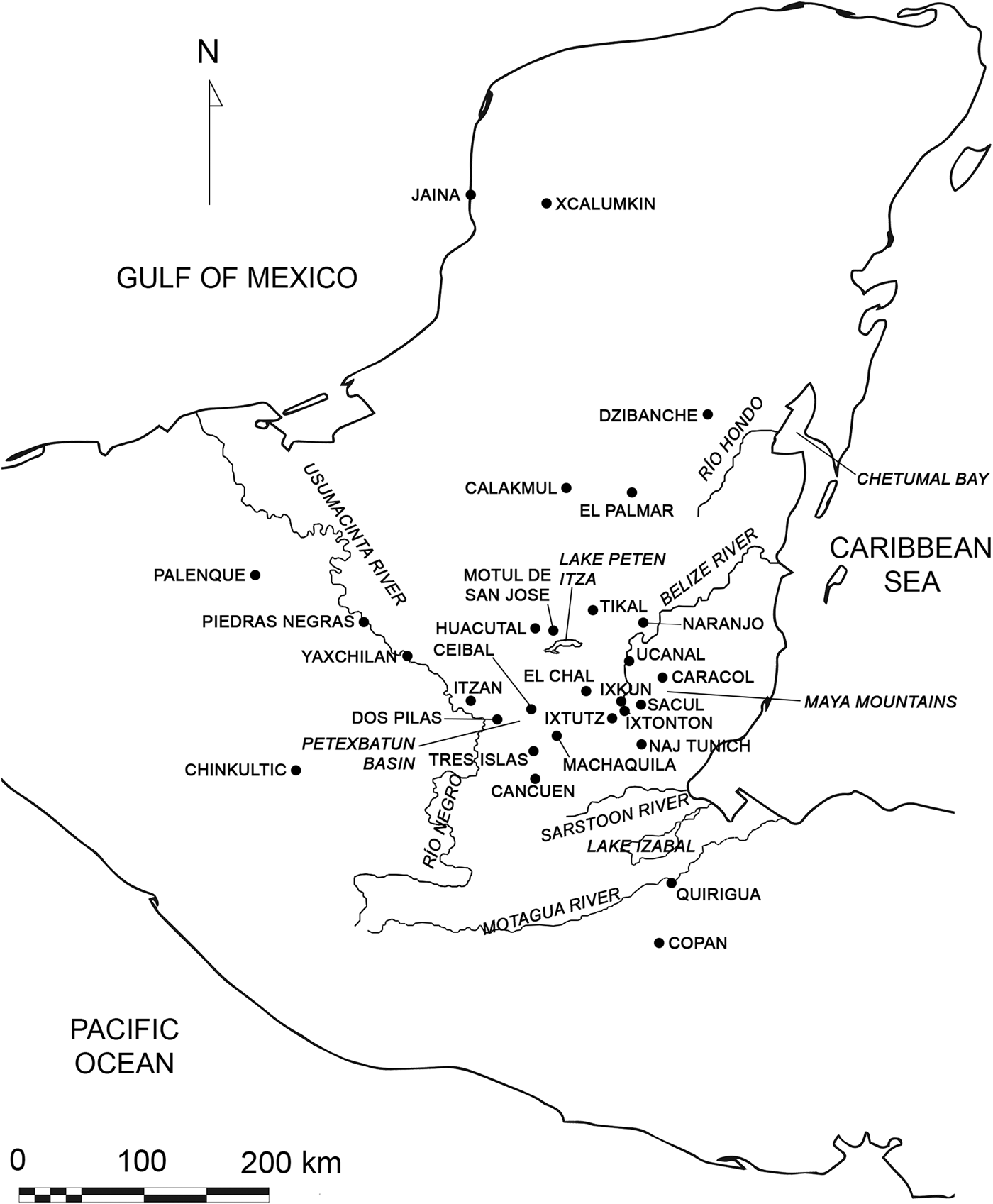
Map of the Maya region, showing sites mentioned in this article and other important centers. Map outline from The Electronic Atlas of Ancient Maya Sites, © 2001, 2002, 2005, 2008, 2009, 2010, Walter R. T. Witschey and Clifford T. Brown.

Ancient Maya settlements in the northwestern Maya Mountains. Map generated by Lauren Santini using Shuttle Radar Topography Mission data (30 m resolution).

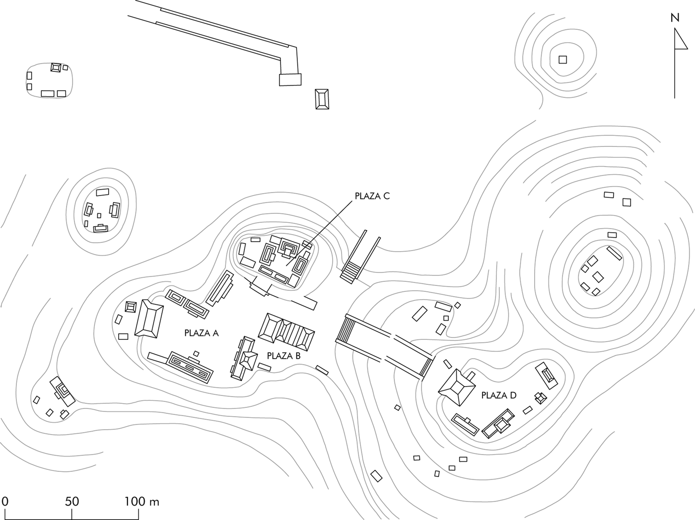
The site center of Sacul 1 (Figure 3) consists of four monumental architectural groups (Plazas A through D), surrounded by a scattering of smaller patio groups, on the artificially leveled crests of a hill overlooking the Sacul River from the east (Laporte and Mejía Reference Laporte and Mejía2006:22–146). Plazas A and D are both delimited by the western pyramids and eastern platforms of E-Groups, with the majority of the site's monuments arranged in front of the eastern platform in Plaza A. Plaza C, composed of three restricted patios accessible from Plaza A by a single stairway, is a good candidate for the site's royal palace.
The monumental core of Sacul 1. Drawing by the author after Ramos Reference Ramos, Laporte and Escobedo1999:Figure 2.

Ixkun (Figure 4) sits near the northern margin of the Maya Mountains, where the terrain begins to descend northward towards the basin of the lower Mopan River. Ixkun's monumental architecture runs along a north-south axis, with a cluster of three plazas in the center from which causeways run north and south, each terminating at an isolated hill. The southern hill has springs and a cave on its western side; both cave and springs were modified in antiquity (Graham Reference Graham1980:136) and may have acquired their evident religious significance (Laporte and Mejía Reference Laporte and Mejía2005:54–57) as reliable sources of water year-round. Monumental buildings define a North, Central, and South Plaza, the North Plaza consisting of an E-Group with some additional buildings. The South Plaza is bounded on its western side by the Acropolis, a palace complex whose elevation belies a shallow stratigraphic sequence: preliminary excavations indicate that it was built atop a modified rise in the limestone bedrock (Laporte et al. Reference Laporte, Escobedo, Morales, Roldán, Torres, Gómez and Fernández1994:37). The whole site contains at least 51 architectural groups, residential and ritual (Laporte and Mejía Reference Laporte and Mejía2005:5, 13–58).
The monumental core of Ixkun. Drawing by Ian Graham, © President and Fellows of Harvard College, Peabody Museum of Archaeology and Ethnology, PM # 2004.15.7.10 (digital file # 122380008).

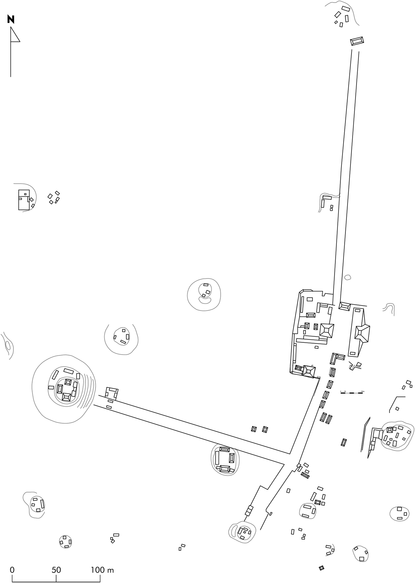
The core of Ixtonton (Figure 5) presents a similar layout to that of Ixkun, with causeways extending north and south from an E-Group and associated plazas. A third causeway leads west from the southern causeway to a cluster of architecture atop a hill, designated “Ixtonton 2” by the Atlas Arqueológico team (Laporte and Rolando Torres Reference Laporte and Torres1988:78). This complex, the most defensible at Ixtonton, is a good candidate for the residence of the site's kings. That Ixtonton was a dynastic capital is suggested by the presence of royal monuments (Laporte et al. Reference Laporte, Torres, Hermes, Laporte, Villagran, Escobedo, de González and Valdés1991:223), most of them now looted. Yet, as discussed below, its proximity to other such capitals complicates the picture. Its monumental core is surrounded by dozens of scattered residential compounds (Laporte et al. Reference Laporte, Torres, Hermes, Laporte, Villagran, Escobedo, de González and Valdés1991:Figure 3).
The monumental core of Ixtonton. Drawing by the author after Laporte and Torres Reference Laporte and Torres1988:Figure 3.

Previous Research
Ian Graham visited Sacul 1 in 1972, preparing a map of the site and field drawings of its monuments (Mayer Reference Mayer1990:1). Soon after, looters damaged several of them, breaking up Stelae 6 and 9 and sawing away the uppermost panel of Stela 1 (Laporte and Mejía Reference Laporte and Mejía2006:5). Ixkun was first described in print in a German article (Ritter Reference Ritter1853) recounting a visit by Colonel Modesto Méndez, the departmental Corregidor for Petén, and an artist, perhaps Eusebio Lara, who drew a just-recognizable rendition of Ixkun Stela 1 (Ritter Reference Ritter1853:Plate 10; see Hammond Reference Hammond1984:96). In 1887, Maudslay (Reference Maudslay1889–1902:vol. 2, Plates 67–69) mapped Ixkun's site core and documented Stela 1 through molding and photography. Morley and Spinden visited in 1914, and Morley (Reference Morley1937–1938:vol. 5, Plates 49, 93) later published Stelae 4 and 5. Graham (Reference Graham1980) documented the site and its monuments in three visits during the 1970s, publishing Stelae 1, 2, 3, 4, and 5 and the altar of Stela 3.
After Graham, most archaeological work in the northwestern Maya Mountains was carried out by the Atlas Arqueológico de Guatemala (AAG) project, begun in 1987 under the direction of Juan Antonio Valdés Gómez and Juan Pedro Laporte Molina. Designed to document and preserve as much of Guatemala's archaeological heritage as possible before sites were damaged amid the government-sponsored colonization of the Department of the Petén, AAG focused on mapping, test-pitting, and the protection of monuments. Laporte's commitment to making the results of AAG's research promptly, widely, and freely available to scholars is evident in the project's voluminous publication record, an invaluable service to Maya archaeology (Corzo Reference Corzo, Arroyo, Paiz and Mejía2012).
The northwestern Maya Mountains was one of the regions AAG documented most thoroughly. Working from a base in Dolores, Laporte and other researchers located and mapped 31 sites in the surrounding area, along with nine others in neighboring zones (Laporte and Morales Reference Laporte, Morales, Laporte and Escobedo1994:210). Using pottery recovered from surface contexts and sounding units, they constructed a ceramic sequence for the region (Laporte Reference Laporte1995b) and identified the broad periods of Maya culture history during which its sites were built and occupied.
With that evidentiary base, reconstructions of the ancient sociopolitical situation in the northwestern Maya Mountains rested on a fairly synchronic reading of the settlement survey data. Laporte et al. (Reference Laporte, Escobedo, Morales, Roldán, Torres, Gómez and Fernández1994:31) identified seven sites—Caxeba, Ix Ek’, Ix Kol, Ixkun, Ixtonton, Ixtutz, and Sacul 1 (Sacul)—as political capitals in the Classic period. Their proposal rested on the size and location of those centers relative to smaller sites in the region, which were understood as secondary centers dependent on those capitals. Yet given the proximity of some of the proposed governing centers to one another, it is questionable whether all seven were simultaneously the seats of distinct royal courts. Alternatively, a smaller number of realms could have included two or more regal-ritual centers, whether their courts used them seasonally or moved permanently from one to the other. Some centers, even of the first rank assigned by Laporte and Morales’ (Reference Laporte, Torres, Laporte, Escobedo and Villagrán1994:212–213) gravity model, could have been the seats of subordinate lords rather than a k'uhul ’ajaw.
Political Geography
Emblem glyphs have been identified at five sites in the region, with another local emblem glyph not yet tied to a known site. The dynastic titles of Ixtutz and Sacul were first recognized by Mathews (Reference Mathews1976), and a stone block from Pueblito bearing another was reported by Chocón (Reference Chocón, Laporte, Arroyo, Escobedo and Mejía2004:229–230). Two other titles used at Ixkun and Ixtonton are discussed here for the first time in print.
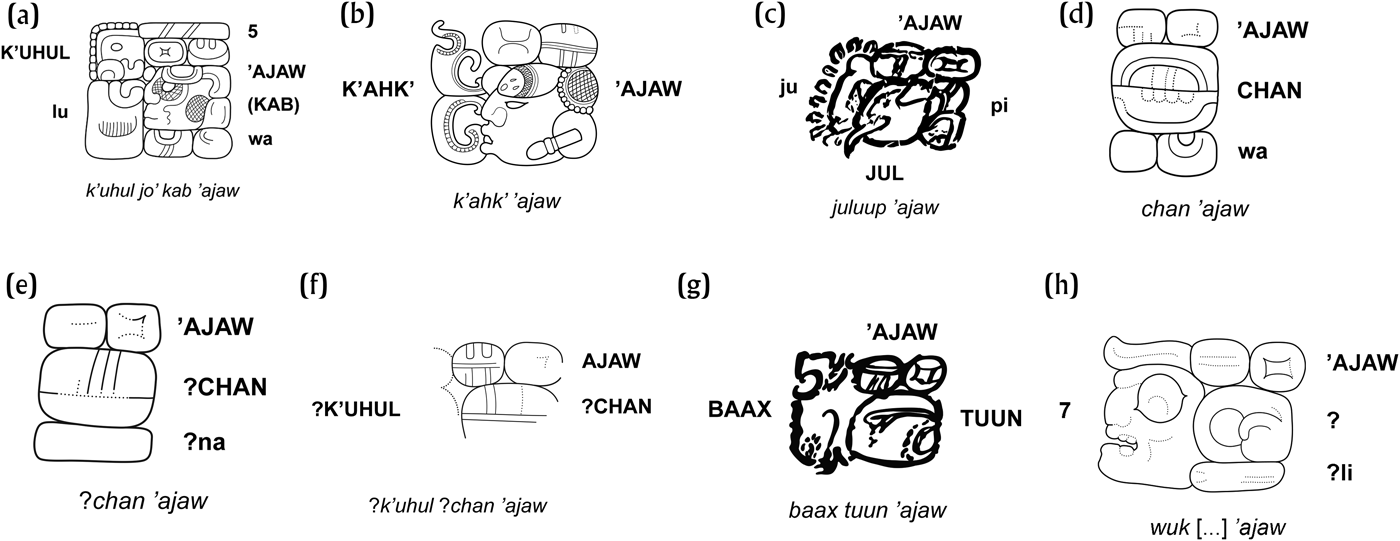
A stela and a fragmentary panel from Ixtutz name a single king with the title of k'uhul Jo’ Kab ’ajaw, “holy Five Lands lord” (Figure 6a), whose undeciphered personal name (missing the title) also appears on another fragmentary block from the same site (Graham Reference Graham1980:171–183; Houston Reference Houston1984:792; Laporte Reference Chocón2009). An unprovenanced fragment of another panel, now in a private collection, is stylistically similar to the known Ixtutz panels. The same royal name appears on the unprovenanced panel followed by K'ahk’ ’ajaw, “Fire Lord” (Figure 6b), which is evidently a second Ixtutz dynastic title (Escobedo 1993:12). A further reference to the Jo’ Kab line—perhaps describing its foundation—comes from Stela P at Pusilha (a.d. 647), at the confluence of the Poite and Pusilha rivers southeast of the Maya Mountains. The eroded final passage of the stela text recalls an event involving a Jo’ Kab ’ajaw in a.d. 81 at a place, important in Classic Maya narratives about the Late Preclassic period, whose name David Stuart (Reference Stuart2014) tentatively read as Chika’ or Chicha’, “Maguey Grinder,” and which Guenter (Reference Guenter2003a) proposed to be El Mirador (Braswell et al. Reference Braswell, Prager, Bill, Schwake and Braswell2004:229; Prager Reference Prager2013:265).
Emblem glyphs for dynasties in the area around Dolores: (a) Jo’ Kab (Ixtutz, from Ixtutz Stela 4, position B4); (b) K'ahk’ (Ixtutz, from an unprovenanced panel in a private collection, pC1); (c) Juluup (Sacul, from Naj Tunich Drawing 82, C3); (d) Chan or Kan (Sacul, from Sacul Stela 9, G3); (e) Ixtonton (possibly Chan or Kan, from Ixtonton Stela 1, B4); (f) Pueblito (possibly Chan or Kan, from a stone block from Group B at Pueblito, pA1); (g) Baax Tuun (from Naj Tunich Drawing 28, A15); and (h) Ixkun (Wuk […], from Ixkun Stela 12, B4). Drawings by the author: (a) and (d) after photographs by Ian Graham, (c) and (g) after photographs by James Brady and Gene Ware (Reference Brady and Ware1999), and (f) after Chocón Reference Chocón, Laporte, Arroyo, Escobedo and Mejía2004:Figure 7.

The Late Classic kings of Sacul used an emblem glyph reading something like k'uhul Juluup ’ajaw, “holy Juluup lord” (Figure 6c). The Jo’ Kab and Juluup titles are both attested in painted texts from the cave of Naj Tunich (MacLeod and Stone Reference MacLeod, Stone and Stone1990:178–181). At least one Sacul ruler, K'iyel Janab, used a second title reading k'uhul Chan ’ajaw or k'uhul Kan ’ajaw, “holy Sky lord” (Figure 6d). The Chan title also belonged to Late Classic rulers named in inscriptions from Jaina and Xcalumkin in northern Campeche (Graña-Behrens Reference Graña-Behrens2006:110–111), as well as at Chinkultic in eastern Chiapas, and Salinas de los Nueve Cerros. This last site, on the border between the Guatemalan departments of Quiché and Alta Verapaz, was an important center for salt production whose rulers were intensely involved in long-distance trade (Wölfel and Wagner Reference Wölfel and Wagner2010; Woodfill Reference Woodfill2016). As discussed above, it may also be attested at Ixtonton and Pueblito. While the Chan title in the Maya Mountains likely refers to a single extended lineage, any familial links between it and Chan lords to the west and north are, on present evidence, only speculative.
Another emblem glyph local to the northwestern Maya Mountains (Figure 6e) appears on Ixtonton Stela 1, a fragmentary monument in the middle of that site's West Plaza (Laporte and Rolando Torres Reference Laporte, Torres, Laporte, Escobedo and Villagrán1994:116). Now much eroded, Stela 1 is best documented in a photograph by Graham in the collection of the Corpus of Maya Hieroglyphic Inscriptions at Harvard's Peabody Museum. It commemorates an incense-scattering ritual carried out on the 10.3.0.0.0 k'atun ending (May 5, 889) by a lord whose damaged emblem glyph differs in its form from the Ixtutz emblem glyph, both of the Sacul titles, and the Ixkun emblem glyph (discussed below). This emblem glyph resembles another (Figure 6f) on a carved stone block from a Late Classic ball court at Pueblito (Chocón Reference Chocón, Laporte, Arroyo, Escobedo and Mejía2004:229–230). The main signs of both titles involve a horizontal line across the middle of the glyph, with vertical lines extending all the way up to the top edge. In visually similar signs, such as syllabic ’i and CHAN/KAN (“sky”), the vertical lines tend to stop at an interior arc that runs parallel to the upper edge of the glyph. Yet CHAN/KAN is highly visually variable across space and time, and in many cases the vertical lines do reach the top of the sign. Despite the late form of the Ixtonton emblem glyph, it may very well be identical with the one from Pueblito, and both may in turn record the same Chan ’ajaw title used at Sacul. Whether kings with the same emblem glyph also ruled at Ixtonton during the eighth century has yet to be established: other than Stelae 1 and 2, the latter carved with a royal portrait but no text, Ixtonton's monuments were looted and have disappeared into private collections (Laporte et al. Reference Laporte, Torres, Hermes, Laporte, Villagran, Escobedo, de González and Valdés1991:223).
Several painted texts at Naj Tunich name people with the title of Baax Tuun ’ajaw, “Quartz Stone lord” (Figure 6g). The title is similar to that borne by rulers of Xultun, Baax Witz ’ajaw (“Quartz Mountain lord”) or, in at least one instance, Baax Tuun Witz ’ajaw (“Quartz Stone Mountain lord”; Prager et al. Reference Prager, Wagner, Matteo and Krempel2010). But Baax Tuun is actually a site in the western Maya Mountains, since its toponym is distinct from that of Xultun and it is not mentioned in known inscriptions other than at Naj Tunich (Garrison and Stuart Reference Garrison, Stuart, Laporte, Arroyo, Escobeda and Mejía2004). That Baax Tuun was a place, not just a family name, is evident from Naj Tunich Drawing 70 (Stone Reference Stone1995:Figure 8–70), which describes one pilgrim as “he of Baax Tuun” (aj Baax Tuun). Baax Tuun has yet to be identified with a known site, however.
Chronology and Occupation
The results of published research by AAG, principally ceramic and stratigraphic data, make possible the following sketch of the settlement chronology of the northwestern Maya Mountains region. This outline focuses on Ixkun and Sacul without completely neglecting the regional context of their development. More fine-grained stratigraphic information is available for Ixkun, where securely dated monuments were found in association with stucco floors, than for the other sites, including Sacul.
Late Preclassic Period (ca. 400 b.c.–a.d. 250)
The area around Dolores was sparsely populated during the Late Preclassic period by comparison to its demographic florescence in the eighth and ninth centuries, but some nucleated settlement was present at Curucuitz, Ixtonton, and Mopan 3-East (Laporte et al. Reference Laporte, Escobedo, Morales, Roldán, Torres, Gómez and Fernández1994:45). Ceramics recovered from the earliest stratigraphic units at Ixtutz (Chocón Reference Chocón2009) and Sacul 1 (Laporte et al. Reference Laporte, Torres, Escobedo, Morales, Laporte, Escobedo and Brady1992:110) point to some settlement there during the same period, but in neither case were those sherds associated with securely Late Preclassic stone architecture. As noted, Pusilha Stela P may recall the accession of the first Jo’ Kab lord in a.d. 81 (Prager Reference Prager2013:265), perhaps marking the beginning of kingship in the Five Lands region.
Sherds from limited excavations by AAG support a minor human presence at Ixkun in the Late Preclassic, principally in the form of ritual activity focused on the caves in the hill at what would become the south end of the site's epicenter. Late Preclassic sherds comprise only 3.6 percent of the AAG sample (Laporte et al. Reference Laporte, Escobedo, Morales, Roldán, Torres, Gómez and Fernández1994:45), and only one possibly Late Preclassic stone construction has been identified: a talud incorporated into Early Classic constructions atop the hill. The wall represents the first phase of masonry construction there, but its precise date is uncertain (Laporte et al. Reference Laporte, Escobedo, Morales, Roldán, Torres, Gómez and Fernández1994:49).
Early Classic Period (a.d. 250–600)
Assessing Early Classic demographic trends in the northwestern Maya Mountains is complicated by the possibility that the styles and techniques of the Late Preclassic Chicanel ceramic sphere persisted there long after being superseded by the Tzakol horizon in northern Petén (Laporte Reference Laporte, Laporte and Escobedo1995a, Reference Laporte1995b). Some parts of Curucuitz, Ix Ek’, and Ix Kol were inhabited from the Late Preclassic into the Late Classic period (Corzo et al. Reference Corzo, Gómez, Alonzo, Aragón and Benitez1994:4–5; Laporte and Morales Reference Laporte, Morales, Laporte and Escobedo1994:228), while a few Early Classic ceramics were found in association with the earliest floors of Plazas A and B at Sacul 1 and at some of its small satellite sites (Laporte and Mejía Reference Laporte and Mejía2006:25, 102, 325). A cache of 229 ceramic vessels and incense burners in Plaza D at Sacul 1 has been suggested to date to the sixth century (Laporte and Mejía Reference Laporte and Mejía2006:122–123), thus predating the Juluup dynasty. Yet the paucity of monumental architecture and inscriptions, combined with the ceramic evidence, still suggests that the region was sparsely populated during the Early Classic. Only Ixtonton and Mopan 3-East appear as significant population nuclei and centers of political power—at least by the limited standards of the region—with some monumental architecture but no known Early Classic inscriptions (Laporte et al. Reference Laporte, Torres, Hermes, Laporte, Villagran, Escobedo, de González and Valdés1991:223). Late Classic Baax Tuun lords used the waxakwinik (“Twenty-Eight”) title that may indicate membership in a political order established in the lowlands after Sihyaj K'ahk”s arrival in a.d. 378 (Tokovinine Reference Tokovinine2013a:113), but that order still left the northwestern Maya Mountains a relative backwater during the Early Classic period. Whatever routes of trade and travel connected the new Maya kingdom at Copan to centers in central and eastern Peten may have bypassed this zone. This dormant epoch contrasts with developments to the north at Caracol, where a royal dynasty ruled over a growing population (Chase and Chase Reference Chase and Chase2008:96–99), and at Ucanal, whose kings were integrated into the alliance network centered on Tikal after a.d. 378 (Martin and Grube Reference Martin and Grube2008:34).
Ixkun, meanwhile, continued as a small community with some religious architecture. Abundant Early Classic censers and offering vessels in the caves testify to their ongoing ritual importance, but Early Classic ceramics only comprise about 7 percent of the sherds recovered by AAG from the site (Laporte et al Reference Laporte, Morales, Laporte and Escobedo1994:41, 45). A few Early Classic buildings on the summit of the south hill represent the second phase of architectural modifications to it, following the talud of early but uncertain date. The principal edifice, Structure 29, consists of a two-chambered shrine atop a pyramidal platform, notable for a monolithic limestone lintel bridging the doors of its rooms (Laporte et al. Reference Laporte, Escobedo, Morales, Roldán, Torres, Gómez and Fernández1994:40). Another masonry building in the hill group, Structure 30, was built as part of the same construction episode, incorporating the earlier talud in its foundations; since it was later covered over with Late Classic architecture, little can be said yet about its form and function. The other six buildings on the summit are no more than low platforms, some or all of which may be Late Classic in date. No other ritual or residential architecture clearly dating to the Early Classic period has been reported, although some scattered domestic groups could have been present. Without evidence of a palace, it is highly unlikely that Ixkun was the seat of a royal court prior to the eighth century (see below); instead, it functioned as a site of pilgrimage and cave ritual visited by the inhabitants of one or more other sites, perhaps the nearby center of Ixtonton.
Late and Terminal Classic Periods (a.d. 600–1000)
The Late Classic period saw a resurgence of population in the northwestern Maya Mountains. The seven governing centers identified by Laporte et al. (Reference Laporte, Escobedo, Morales, Roldán, Torres, Gómez and Fernández1994:31) flourished as demographic and ritual foci during some part of this period, with monumental architecture present at all seven sites and royal sculpture documented at Ixkun, Ixtonton, Ixtutz, and Sacul 1. From the dates on associated monuments at Ixkun and Sacul 1, much of the Late Classic masonry architecture at those sites is specific to the eighth century, but whether similar patterns obtain at other sites in the region remains to be confirmed by detailed stratigraphic excavation.
Economic connections between the Dolores region and areas to the north and east are evident. Several Late Classic polychrome cylinder vessels excavated by the Atlas Arqueológico in this area appear to have been produced at elite workshops at other sites. Two vessels recovered from Ixkun are attributed on the basis of style to one or two workshops in the area of Lake Peten Itza, at Motul de San José, or a still-unidentified site called Tubal, probably located between Tikal and Naranjo (Reents-Budet et al. Reference Reents-Budet, Ball, Bishop, Fields and MacLeod1994:175; Tokovinine Reference Tokovinine2006:364–370). Another, from Curucuitz, is painted in the “codex style” of the Mirador Basin (Coe Reference Coe1978:16; Hansen et al. Reference Hansen, Bishop and Fahsen1991; Tokovinine Reference Tokovinine2006:380). A vessel found at Sacul 1 is painted in the “Holmul style” common at Buenavista del Cayo, plausibly a vassal kingdom subject to Naranjo during the eighth century, while the dedicatory text on another includes the royal titles of a king of Naranjo (Tokovinine Reference Tokovinine2006:372–376).
Most monumental architecture at Sacul 1 was built during the Late Classic period. Laporte et al. (Reference Laporte, Torres, Escobedo, Morales, Laporte, Escobedo and Brady1992:110) suggested that Plaza D could be older than other parts of the site, but limited excavations and the lack of monumental inscriptions in the make firm statements about the relative chronology of Sacul 1's architecture impossible for the moment. Those monuments with surviving dates, all in Plaza A, belong to the late eighth century (Laporte et al. Reference Laporte and Mejía2006). Occupation at Sacul 1 continued into the Terminal Classic period, with ceramic, stone, and shell artifacts indicating both ritual and domestic activity (Laporte and Mejía Reference Laporte and Mejía2006:36, 40; Ramos Reference Ramos, Laporte and Escobedo1999). Limited masonry and stucco construction projects suggest both the presence of political-religious elites at the site and their diminished capacity to mobilize labor and resources (Laporte and Mejía Reference Laporte and Mejía2006:49, 96, 99). Similarly, most of the exposed monumental architecture at Ixtonton appears, on preliminary evidence, to date to the Late Classic period, with the potential palace complex on the western hill also undergoing some remodeling during the ninth century (Laporte et al. Reference Laporte, Torres, Hermes, Laporte, Villagran, Escobedo, de González and Valdés1991:222–225).
Ixkun underwent new growth in the eighth century, when the first stucco floors of the North and Central Plazas (the latter not yet a distinct space) were laid down, and when the eastern and western structures of the site's E-Group were built (Laporte et al. Reference Laporte, Escobedo, Morales, Roldán, Torres, Gómez and Fernández1994:34). Subsequently, a second floor was deposited over the first floor of the North Plaza. This extended south to pave the areas of the Central and South Plazas, which were defined as distinct from the North Plaza by the construction of new buildings during the same second episode. New structures included the ball court southeast of Structure 3 and Structures 5 and 1 at the north and south ends of the North Plaza, respectively; they also included Patio 1 of the Acropolis, the first clearly royal residential structure built at Ixkun (Laporte et al. Reference Laporte, Escobedo, Morales, Roldán, Torres, Gómez and Fernández1994:35; Laporte and Mejía Reference Laporte and Mejía2005:160). Stelae 2 and 12, associated with this second period of construction, date it to around a.d. 780. A third floor, again present in all three plazas, corresponded to the erection of Stela 1 (a.d. 790) in the North Plaza (Laporte and Mejía Reference Laporte and Mejía2005:160).
Late Classic ceramic sherds comprise 23.3 percent, and Terminal Classic sherds 65.7 percent, of the sample collected by AAG (Laporte et al. Reference Laporte, Escobedo, Morales, Roldán, Torres, Gómez and Fernández1994:46), indicating a robust occupation into the early ninth century. The erection of Stela 5 (a.d. 800) at the end of the South Causeway (Graham Reference Graham1980:136) and the construction of a Terminal Classic addition to the Acropolis (Patio 2) indicate that a royal court survived during some of that time. Yet Structure 18 in Patio 2, and Structures 10 and 11 in the Central Plaza, were never finished (Laporte et al. Reference Laporte, Escobedo, Morales, Roldán, Torres, Gómez and Fernández1994:36, 46). Kingship at Ixkun seems to have ended by the tenth bak'tun ending (a.d. 830), which was not commemorated on any surviving inscriptions at the site. Ixkun's population declined precipitously, with only a few households remaining in the area by the end of the tenth century (Laporte et al. Reference Laporte, Escobedo, Morales, Roldán, Torres, Gómez and Fernández1994:46–47). Nearby Ixtonton hosted a dynasty, perhaps a branch of the Chan line, until at least the third k'atun ending of the new bak'tun (a.d. 889), the date of Ixtonton Stela 1, but that dynasty appears inactive soon thereafter.
HISTORY AND HEGEMONY IN THE NORTHWESTERN MAYA MOUNTAINS
There are four carved stelae (Stelae 1, 2, 3 and 9) at Sacul 1. Of these, prior to its mutilation, Stela 1 was the only one with a long text not damaged by erosion; Stelae 2 and 3 are badly eroded and virtually illegible. Stelae 1 and 9 name a single ruler, K'iyel Janab (Figure 7a), who also commissioned Stela 2 (see below). He is called “fourth in the lordship” (kan ta ’ajawlel) on Stela 1 (March 18, 761, using the 584,286 correlation between the Classic Maya and Christian calendars [see Martin and Skidmore Reference Martin and Skidmore2012]), a monument erected early in his reign. If his three predecessors had average reigns of about 19 years, as Tikal's kings did during the period from a.d. 426–768 (Culbert Reference Culbert, Kosakowsky, Fry, Haviland, Culbert and Rice1990:109), then the Juluup dynasty could have begun in the early years of the eighth century. Such a date would be consistent with the archaeological evidence adduced above.
Names and titles of Juluup lords: (a) K'iyel Janab (Sacul Stela 1, positions A8-B8 and C5-C8); (b) ?Aj Chik (Naj Tunich Drawing 49, A3–A6); (c) Chak Bolay To'k’ (Naj Tunich Drawing 82, C2–C3); (d) SAK-bo-? (Naj Tunich Drawing 25, B2–B5). Drawings by the author after (a) photograph by Ian Graham and (b–d) photographs by James Brady and Gene Ware (Reference Brady and Ware1999).

Painted texts at Naj Tunich record visits by three people with the title of Juluup ’ajaw, omitting the k'uhul. One, ?Aj Chik (Figure 7b; Drawing 49 in Stone Reference Stone1995:Figure 8–49), “went down” (kojoyi) into the cave, but the inscription is undated. Another (Chak Bolay To'k’, Figure 7c; Drawing 82 in Stone Reference Stone1995:Figure 8–82) “oversaw” (u kabjiiy) a pilgrimage in 744 by the Caracol ruler Tum Yohl K'ihnich (MacLeod and Stone Reference MacLeod, Stone and Stone1990:179). A third (SAK-bo-[…], Figure 7d; Drawing 25 in Stone Reference Stone1995:Figure 8–25) visited in the company of two Baax Tuun lords in 763. He must have been a junior member of the Juluup royal family, since the visit occurred during K'iyel Janab’s reign (Barbara MacLeod, personal communication 2016; Tokovinine Reference Tokovinine2013b). An unprovenanced, painted bowl (Kerr Reference Kerr2014:K3394) in the Museo Popol Vuh at Francisco Marroquin University dated to 9.15.0.0.0 (a.d. 731) belonged to an unnamed “young Juluup lord,” perhaps a predecessor of K'iyel Janab.
Texts at Naj Tunich recording joint pilgrimages point to friendly relations among Sacul, Ixtutz, and Baax Tuun during the mid-eighth century. They also indicate that kingdoms outside the western Maya Mountains were part of that alliance network: besides Caracol, lords visited Naj Tunich from the Yokeel polity in the area of Huacutal, near Motul de San José (Tokovinine Reference Tokovinine2013b); from Ucanal, north of Sacul along the Mopan River; from the powerful Kan court at Calakmul, in southern Campeche; and perhaps from smaller sites, El Palmar or Chacchoben, between Calakmul and the Caribbean coast (Dmitri Beliaev, personal communication to Kenichiro Tsukamoto, cited in Tsukamoto and Esparza Olguín Reference Tsukamoto, Olguín, Golden, Houston and Skidmore2016). Other ties between Sacul and other kingdoms are suggested by K'iyel Janab’s second emblem glyph, k'uhul Chan ’ajaw, discussed above.
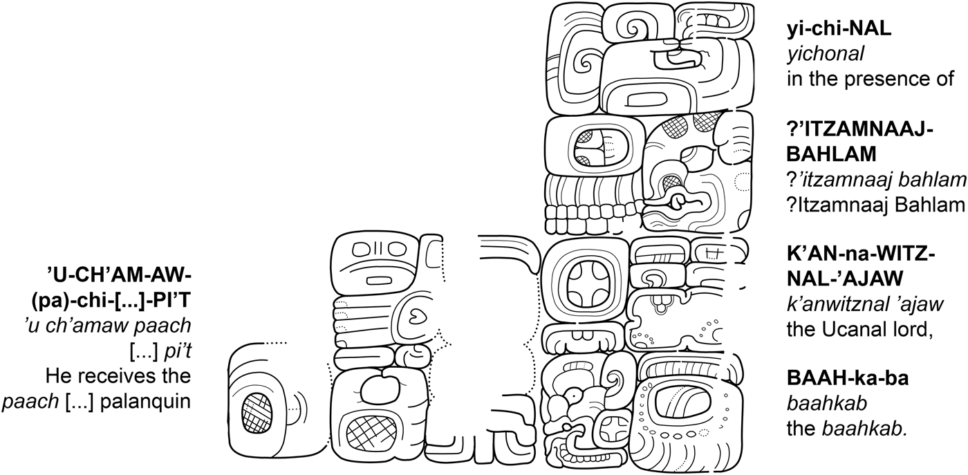
K'iyel Janab first enters the surviving monumental record on Stela 1, an all-textual monument with three panels of hieroglyphs recording the 9.16.10.0.0 half-k'atun ending of a.d. 761. The upper two panels present the young king as a master of ritual performance on the period ending, manifesting in his person the solar deity K'ihnich ’Ajaw and the so-called “Paddler Gods,” a pair of supernatural beings related to the dusk, the dawn, and rain (see Lacadena Reference Lacadena García-Gallo, Vail and Hernández2010:387), among other supernatural beings. The most interesting part of the stela text follows in the bottom panel (Figure 8): 399 days before the half-k'atun ending, in February of 760, K'iyel Janab is said to have received gifts including a palanquin (pi't), an important symbol of rulership, in the presence of a king of Ucanal, ?Itzamnaaj Bahlam II (yichnal ?Itzamnaaj Bahlam K'anwitznal ’ajaw baahkab). This event must have occurred early in K'iyel Janab’s long reign and may even mark his accession to the throne. In Classic Maya courtly culture, such a gift highlighted the subordination of a vassal lord, in this case K'iyel Janab, to his protector, in this case ?Itzamnaaj Bahlam II (see Stone and Zender Reference Stone and Zender2011:31). The significance of that patron-client relationship for the western Maya Mountains has to be understood in the historical context of conflicts among more powerful Late Classic kingdoms.
Passage in glyph blocks A10–C10 of Sacul Stela 1, recounting K'iyel Janab’s receipt of a palanquin from ?Itzamnaaj Bahlam II of Ucanal. Drawing by the author after a photograph by Ian Graham.

Under the ruler Aj Numsaaj Chan K'ihnich (a.d. 546–615 or later; Alexandre Tokovinine, personal communication 2016), the powerful city of Naranjo was a client state of the Kanal court, at that time based in Dzibanche. The next two kings, however, warred with the neighboring kingdom of Caracol—itself a Kanal vassal—and with their former patron polity. Around a.d. 680, an invading army, likely combining forces from Caracol and the new Kanal capital of Calakmul, attacked Naranjo and apparently extinguished the ruling branch of its Sa'al dynasty. The founder of the Dos Pilas branch of the Mutul dynasty, another Kanal dependent, supplied a daughter to “restart” the royal line, presumably by marrying into another Sa'al faction in a.d. 682 (Martin and Grube Reference Martin and Grube2008:72–77).
This formidable queen, Ix Wak Chan Lem ’Ajaw, set about expanding and consolidating Naranjo's territorial control in eastern Peten. Acting through her young son K'ahk’ Tiliw Chan Chahk, she oversaw a series of conquests described in one text as a tz'akkab or “land-ordering” at the end of the seventh century (Alexandre Tokovinine, personal communication 2015). Among these was an attack on Ucanal and the capture of its king, the first ?Itzamnaaj Bahlam, in a.d. 698. Naranjo Stela 22 (a.d. 702) shows ?Itzamnaaj Bahlam I as an emaciated prisoner destined for sacrifice. Ten years later, in a.d. 712, K'ahk’ Tiliw Chan Chahk oversaw the accession of a new vassal king at Ucanal, none other than ?Itzamnaaj Bahlam II (Schele and Friedel Reference Schele and Friedel1990:189–192). Ucanal's subordination may have continued under K'ahk’ Tiliw Chan Chahk’s successor Yax Mayuy Chan Chahk, who was in power by the early 740s. But in a.d. 744, ?Itzamnaaj Bahlam II appears to have had political independence thrust upon him when an army from Tikal sacked Naranjo, carrying off its king and patron gods (Martin Reference Martin, Macri and McHague1996). Yax Mayuy Chan Chahk’s two successors managed only one inscribed monument between them during the next 36 years, suggesting that Naranjo itself had been reduced to vassal status (Martin and Grube Reference Martin and Grube2008:78–79).
Deprived of Naranjo's patronage, and evidently unable or unwilling to submit to rule from Tikal, ?Itzamnaaj Bahlam II established himself as a local overlord late in his reign. By a.d. 760, his vassals included K'iyel Janab at Sacul and a lord of El Chal to the west. He oversaw rituals at the latter site, recorded on El Chal Stelae 4 (9.16.10.0.0, a.d. 760) and 5 (9.16.10.0.0, a.d. 760; see Morales and Laporte Reference Morales and Laporte1995). Through his vassals, ?Itzamnaaj Bahlam II thus exercised authority over the San Juan and Sacul Rivers, dominating two major transit routes connecting the northern Mopan River basin with areas to the south and west. Control of those corridors was likely key to Ucanal's independence: Tikal and the new Naranjo regime were well-placed to block access from Ucanal to the Peten Lakes chain, a partially lacustrine route towards the Petexbatun Basin, and the Belize River, a natural route to the Caribbean coast. To participate in long-distance trade in obsidian and luxury items, ?Itzamnaaj Bahlam II had to find alternate routes through the Maya Mountains.
The Sacul-Ucanal alliance unraveled by a.d. 779 when K'iyel Janab moved to assert his own power over those routes. He did so by commissioning new courtly and religious constructions at Ixkun, sending a vassal to rule there on his behalf, and ultimately raising that vassal to the status of k'uhul ’ajaw with his own dynastic emblem glyph. The king of Ucanal violently contested K'iyel Janab’s show of independence, ultimately without success. The events in question are described on two all-textual monuments at Ixkun, Stelae 2 and 12, which were both erected for the 9.17.10.0.0 half-k'atun ending of a.d. 780.
Stela 12 (Figure 9) describes four sequential events. First, a person named Yukuul Chan ’Ahk (Figures 10a–10b) was “consecrated” (k'uhbaj) on a Calendar Round date 4 Ix 7th Zotz’ (9.17.8.5.14, April 7, 779; Barbara MacLeod, personal communication 2016). Forty-three days later, on 8 Caban 10 Xul (9.17.8.7.17, May 20, 779; the numeral 13 is substituted for 8 in the text through scribal error), he “settled” (?kajayi; Beliaev Reference Beliaev2014) or “arrived” (?k'otoyi; Stephen Houston, personal communication 2015) at Ixkun, whose toponym is written with an undeciphered logogram depicting the head of a square-nosed supernatural being. In other inscriptions, ?kajayi consistently refers to the acts of kings: their first arrival at or return to a place (see Tokovinine Reference Tokovinine2013a:79–81).
Preliminary drawing of Ixkun Stela 12 by the author.

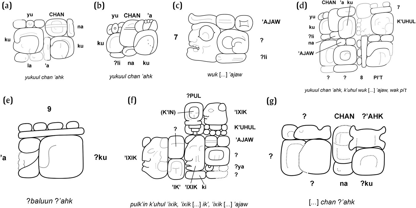
(a) Personal name of Yukuul Chan ’Ahk (Ixkun Stela 12, position B2); (b) personal name of Yukuul Chan ’Ahk (Ixkun Stela 1, J1); (c) Ixkun emblem glyph (Ixkun Stela 12, B4); (d) personal name and royal titles of Yukuul Chan ’Ahk (Ixkun Stela 1, N1–O2); (e) additional name or title of Yukuul Chan ’Ahk (Ixkun Stela 1, C4); (f) names and titles of Yukuul Chan ’Ahk’s mother (Ixkun Stela 1, K2–K4); (g) name of Yukuul Chan ’Ahk’s father (Ixkun Stela 1,J5–K5). Drawings by the author.

A Distance Number at position A5 counts forward 113 days from Yukuul Chan ’Ahk’s arrival. This interval leads to 9.17.8.13.10, 4 Ok 3 Ceh (September 10, 779, a date also referenced on Stela 2), but that is not the recorded Calendar Round date. Instead, the text continues with the date 12 [Ahau] 8 Pax—the date of the 9.17.10.0.0 period ending (December 3, 780)—and describes the dedication of the stela.

Yukuul Chan ’Ahk bears an emblem glyph not previously documented, in position B4 of the text (Figure 10c). It includes the typical ’ajaw superfix, a logogram incorporating a cartouche and an element resembling T528 TUUN/ku, and a subfixed sign that could be syllabic -li. This, not the Juluup title, is the Ixkun emblem glyph. The head variant of the numeral seven occupies the left half of glyph block B4, but in another instance of the Ixkun royal title (on Ixkun Stela 1, positions O1 and N2; see Figure 10d), a bar-and-dot seven replaces the head variant.
Ixkun Stela 2 (Figure 11) continues the historical narrative from Stela 12. According to its inscription, a place called Juluupil “got burned” (puluyi) on December 22, 779. The attack was overseen by a person with a partially-eroded name known to epigraphers as “Eight Skull.” The next day, an unnamed Juluup lord “axed” a site not otherwise known from the hieroglyphic corpus (ch'ahkaj tahn ch'e'n wi-CHAN-na-?-?-5-?). Fifty days later, someone “burned” Ucanal (puluyi K'anwitznal).
Ixkun Stela 2. Drawing by Ian Graham, © President and Fellows of Harvard College, Peabody Museum of Archaeology and Ethnology, PM # 2004.15.6.4.2 (digital file # 99310039).

The text closes with a description of an incense-scattering ritual, presumably on the 9.17.10.0.0 period ending, which is connected to an earlier, unspecified event by a Distance Number of one tun, four winals, and 10 days. The earlier date should therefore be 9.17.8.13.10, 4 Oc 3 Ceh (September 10, 779), the same date referenced by the second Distance Number on Stela 2. If so, however, the Calendar Round date from which the Distance Number counts forward is in error, because it is written as 7 […] 2 Sec.

In Laporte and Mejía's (Reference Laporte and Mejía2005:158) interpretation of Stela 2, Juluupil is Sacul and all three attacks recorded in the text represent aggression by Eight Skull of Ixkun against his neighbors. That Sacul and Juluupil are one and the same is indeed almost certain, especially since Yukuul Chan ’Ahk used an emblem glyph unrelated to the Juluup title. Yet a close look at the broken glyphs in position D1, immediately after Eight Skull's name (Figure 12), reveals the Ucanal dynastic title K'anwitznal ’ajaw (K'AN-na-WITZ-[…]; Helmke and Brady Reference Helmke, Brady, Helmke and Sachse2014:217; see Stuart and Houston Reference Stuart and Houston1996:20–21). With that reading, the narrative becomes a tale of revenge of the sort well-known from other Classic Maya inscriptions. Sacul was attacked by forces from Ucanal led by Eight Skull, who may have been ?Itzamnaaj Bahlam II's heir. K'iyel Janab retaliated first by raiding a dependent town of Ucanal, and later Ucanal itself.
Detail of the text on Ixkun Stela 2 naming “Eight Skull” as a lord of Ucanal: (a) photograph by Ian Graham, © President and Fellows of Harvard College, Peabody Museum of Archaeology and Ethnology, PM # 2004.15.5.4.2 (digital file # 99320021); and (b) drawing by the author.

A third monument attests that K'iyel Janab’s bid for independence was successful, and that his patron-client relationship with Yukuul Chan ’Ahk was still sound ten years later. Ixkun Stela 1 (9.18.0.0.0, October 12, 790), a 3.72 m tall monument erected in the center of the North Plaza, facing Structure 6, depicts both kings. Rendered at the same scale, wearing virtually identical regalia—only some details of their Principal Bird Deity headdresses differ—the rulers face each other, standing over two bound captives amid clouds of incense smoke (Figure 13; Laporte and Mejía Reference Laporte and Mejía2005:163–164;). Ixkun Stela 1 has a terribly eroded counterpart at Sacul, Stela 2, which records the same k'atun ending and again shows both kings at the same scale (Laporte and Mejía Reference Laporte and Mejía2006:240). Such presentations visually suggest their equality, but a caption in the figural scene on the Ixkun stela records that K'iyel Janab “oversaw” (u kabjiiy) Yukuul Chan ’Ahk’s offering of incense to the Paddler Gods—a clear statement of the Sacul lord's political superiority.
Ixkun Stela 1. Drawing by Ian Graham, © President and Fellows of Harvard College, Peabody Museum of Archaeology and Ethnology, PM # 2004.15.6.4.1 (digital file # 99320063).

Yukuul Chan ’Ahk’s name appears twice in the main text (Figures 10c–d), and he takes an additional name or title in a caption in the figural scene (Figure 10e). The main text describes Yukuul Chan ’Ahk’s celebration of the k'atun ending and names his parents. His mother takes a dynastic title (Figure 10f) that, though eroded, is not the Ixkun emblem glyph identified on Stela 12. His father (Figure 10 g) is not attributed a royal title of any kind, consistent with the proposal that Yukuul Chan ’Ahk was the first king of the Ixkun dynasty. Both of the captives on the stela are named in hieroglyphic captions beneath them. The caption on the left includes the title K'ahk’ ’ajaw, suggesting hostile relations between Ixtutz and the Sacul-Ixkun alliance around the time the stela was carved.
DISCUSSION
From the settlement survey data alone, Ixkun and Sacul 1 might appear as the capitals of equally sovereign peer polities, and the chronological relationship between them would be difficult to determine. By contrast, hieroglyphic inscriptions indicate that Ixkun became a royal capital with Sacul's support about eighty years after the inception of kingship at the latter site, and that its first ruler, Yukuul Chan ’Ahk, was dependent on K'iyel Janab. Yet such texts have very little to say about what those events meant for the larger population or the physical landscape of Ixkun. Only by combining archaeological and epigraphic data, with careful attention to the stratigraphic contexts of inscriptions, can a fuller picture be constructed of political and social dynamics in the northwestern Maya Mountains and adjoining areas at the end of the Late Classic period.
Contrary to earlier interpretations (e.g., Laporte and Mejía Reference Laporte and Mejía2005:158; Laporte et al. Reference Laporte, Escobedo, Morales, Roldán, Torres, Gómez and Fernández1994:42), Ixkun was not a royal capital before a.d. 779. Rather than enemies in the wars recorded on Ixkun Stela 2, Yukuul Chan ’Ahk and K'iyel Janab were respectively junior and senior partners in a campaign to dominate the local landscape. The “consecration” of Yukuul Chan ’Ahk was one important step in that process; his “settling” at Ixkun was another. His arrival at Ixkun, described on Stela 12, initiated the major Late Classic construction episode at the site, when the Acropolis was built and the Central and South Plazas paved. When Eight Skull of Ucanal responded to the provocation by attacking the Sacul kingdom, the allies cemented their independence with a successful defense and counterattack.
Yukuul Chan ’Ahk’s use of an emblem glyph indicates a claim to unitary authority within his domain, as opposed to the kinds of specialized authority pertaining to offices like aj k'uhu'n or yajaw k'ahk’ (Jackson Reference Jackson2013:10–15). At the same time, it may be significant that he did not use the exalted title of k'uhul ’ajaw (“holy lord”) on Stela 12, only ’ajaw (“lord”). The difference could highlight his subordination to K'iyel Janab. Nor is it clear that his “consecration” corresponded to accession to the status of ’ajaw, since k'uhbaj nowhere else describes royal accession; other expressions involving seating or the emblems of kingship are used instead. Perhaps he became an ’ajaw or k'uhul ’ajaw on 9.17.8.13.10, the enigmatic date referenced on Stelae 2 and 12 (Barbara MacLeod, personal communication 2016), although it is puzzling why that event should be alluded to but not made explicit. In any case, he certainly was an ’ajaw by the 9.17.10.0.0 half-k'atun ending, and he was a k'uhul ’ajaw by the time Stela 1 was erected ten years later, while remaining a vassal of the king of Sacul. His court was probably never very large: the close stylistic similarities between monuments at Ixkun and Sacul raise the possibility that they were produced by the same few artists, likely based at the dominant center, and an aborted effort to expand Ixkun's Acropolis was only made in the early ninth century (Laporte et al. Reference Laporte, Escobedo, Morales, Roldán, Torres, Gómez and Fernández1994:36, 46).
The fact that K'iyel Janab chose to sponsor a discrete kingdom at Ixkun offers insights into the political culture of the southeastern Maya lowlands in the eighth century. The Sacul ruler neither annexed Ixkun as a secondary center within his realm, as Ruler 3 of Dos Pilas did with Ceibal (Martin and Grube Reference Martin and Grube2008:61–62), nor governed it through a non-royal noble whose title marked him explicitly as a subordinate lord, as kings of some western sites preferred to do (e.g., Chinchilla and Houston Reference Chinchilla and Houston1993:56; Houston and Stuart Reference Houston, Stuart, Inomata and Houston2001:73). Instead, his strategy imitated that of lowland suzerains like the Kanal and Mutul kings, who demonstrated the plenitude of their power by making other kings.
Practical considerations must have motivated that strategic choice. Cut off from the Belize River, ?Itzamnaaj Bahlam II of Ucanal needed K'iyel Janab and the ruler of El Chal as vassals because they controlled alternative trade routes—in K'iyel Janab’s case, the Sacul River valley. Sacul's prosperity, such as it was, depended on that route. If K'iyel Janab wished to assert his independence from ?Itzamnaaj Bahlam’s successor, he would have to prevent Eight Skull from accessing an alternative path across the western Maya Mountains. The relatively easy terrain of the Dolores Plateau offered just such an alternative, and Ixkun was well-placed to block access to it from the north. By controlling Ixkun, he could force Eight Skull to deal with him as an equal. Yet Ixkun's location also would have made it difficult to administer directly from Sacul, given the limited power of the Juluup court, and constructing a chain of outposts between Ixkun and Sacul may not have been feasible. Instead of physical surveillance, ties of loyalty would bind Yukuul Chan ’Ahk to K'iyel Janab.
One major underexplored factor in these events is the role of other kingdoms in the western Maya Mountains. For instance, the position of Mopan 3-East between Ixkun and Sacul, overlooking the Mopan River, suggests that K'iyel Janab would have needed to control it as well. Ixtonton, whose rulers erected stelae in the eighth and ninth centuries, is sufficiently close to Ixkun that it could have posed a serious threat to a court established there without its king's consent. Did a ruler of Ixtonton cooperate in the foundation of Ixkun, or did K'iyel Janab compel him to do so? Alternatively, given the similarity between K'iyel Janab’s Chan emblem glyph and the titles attested at Ixtonton and Pueblito, Ixtonton might have been part of the Sacul lord's domain by virtue of a family connection. Military conflict between Ixtutz and the Ixkun-Sacul alliance is evident by a.d. 790, the date of Ixkun Stela 1, but what was the role of Ixtutz in the region during the period of dominance by Ucanal? Other issues of demographic and economic developments need further exploration. Why were the northwestern Maya Mountains sparsely settled for so long by comparison to areas to the north and northwest, and why did new kingdoms begin to be founded there in the Late Classic period? How were its local economies integrated with one another and with larger networks of travel and exchange? The answers will depend on further regional excavations and the identification of relevant looted monuments in private collections.
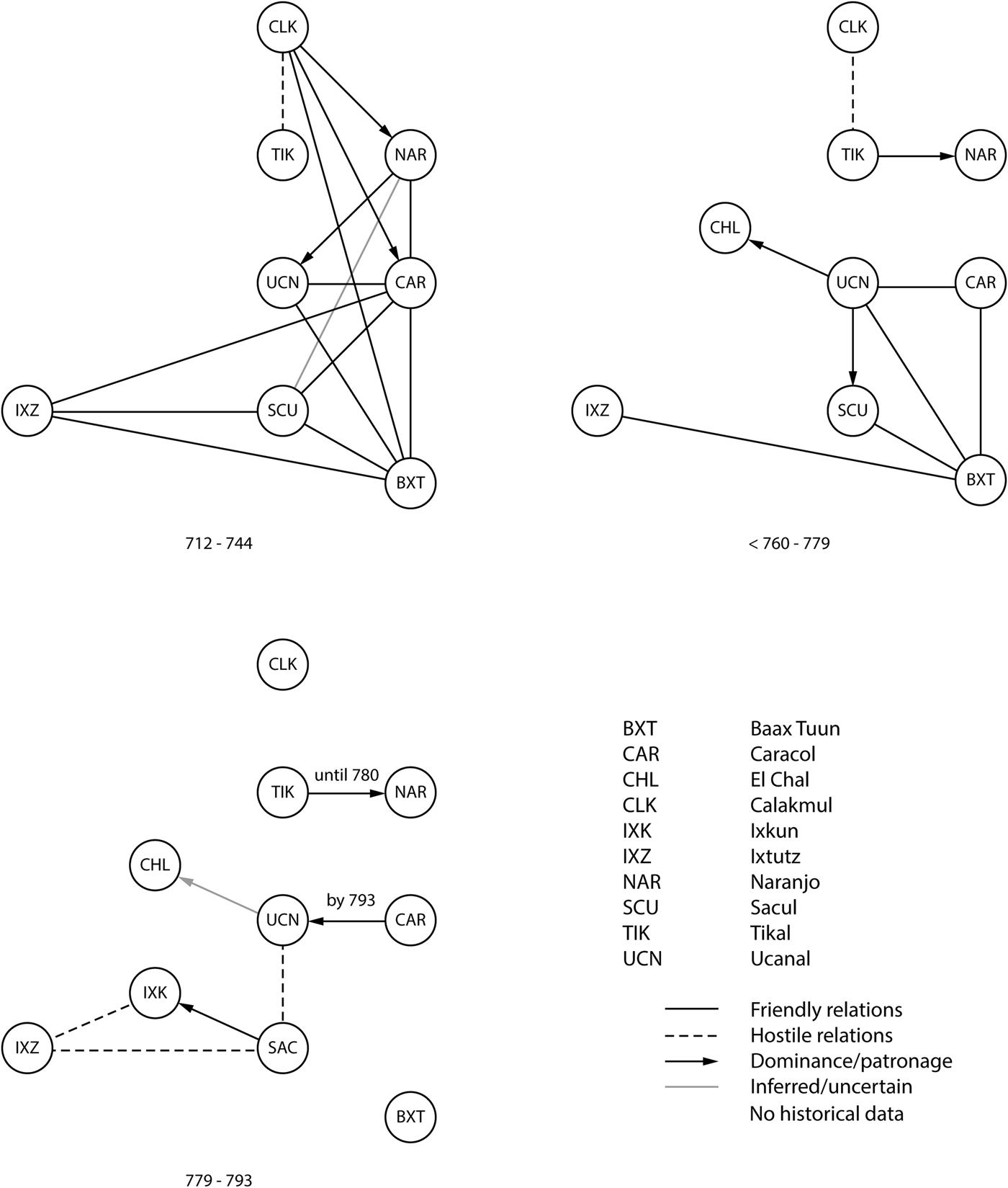
The case of Ixkun indicates that the proliferation of royal titles in the eighth century was not always due to the fragmentation of authority within existing polities. In contrast to events at Quirigua and Río Amarillo, for instance, the appearance of the Ixkun emblem glyph marks political expansion on a local scale: the growth of a new alliance structure centered on the king of Sacul. At a larger scale, the historical trajectory described above remains one of disintegration—the disintegration of alliances, not of states—as first the Calakmul-centered network, then the smaller one with Ucanal at its head, broke down (Figure 14).
Chart showing relationships among kingdoms discussed in this article between a.d. 712 and a.d. 793.

RESUMEN
En el presente artículo se investiga la práctica de lo geopolítico en la zona noroeste delas Montañas Mayas en el sureste del Petén, Guatemala, una region donde nuevas dinastías reales fueron establecidas en el período clásico tardío. Datos arqueológicos y epigráficos sugieren que el paisaje político de la región se le dio forma por conflictos entre gobernadores locales y foráneos. Una estrategia en tales conflictos fue establecer cortes reales, nominalmente independientes, cuyos reyes debían sus posiciones a patrones locales. Esta estrategia reprodujo en una escala menor las maquinaciones de los hegemones mayas como Tikal y Calakmul, un hecho que destaca las limitaciones prácticas e ideológicas de la institución de monarquía maya.
Se argumenta que un rey del sitio de Sacul, K'iyel Janab, precipitó una guerra contra su ex patrón el rey de Ucanal cuando estableció una nueva dinastía, bajo su dominio, en el sitio de Ixkun en d.C 779. El recuerdo jeroglífico describe la guerra y la carrera del primer rey de Ixkun, Yukuul Chan ’Ahk. El narrativo histórico que aquí se presente añade una dimensión temporal a estudios previos del asentamiento en la región. También sirve como un estudio en el cambio geopolítico en un parte relativamente periférico del mundo maya clásico y en la integración de evidencia textual y arqueológica para reconstruir tales procesos.
ACKNOWLEDGMENTS
I am obliged to Karen Bassie, Jessica Christie, Bryce Davenport, Jeffrey Dobereiner, Markus Eberl, Charles Golden, Nikolai Grube, Stephen Houston, Takeshi Inomata, Danny Law, Katharine Lukach, Barbara MacLeod, Sarah Newman, Franco Rossi, Lauren Santini, Andrew Scherer, David Stuart, Alexandre Tokovinine, Marc Zender, and two anonymous reviewers for their comments on this paper and the ideas in it. Barbara Fash and Jessica Desany were more than generous in allowing the use of images belonging to the Corpus of Maya Hieroglyphic Inscriptions and Peabody Museum of Archaeology and Ethnology—all of them produced by Ian Graham, a hero of the field. Some of the research presented here was carried out during a 2013–2014 Junior Fellowship at Dumbarton Oaks Research Library and Collection, benefiting from questions and comments by Colin McEwan. I wrote this article while a Fellow with the David Rockefeller Center for Latin American Studies at Harvard University, supported by the Santander Program for Research and Conservation of Maya Sculpture. My ongoing geospatial research in the Dolores region is supported by a SPARC award. The SPARC program is based at CAST at the University of Arkansas, and is funded by a generous grant from the National Science Foundation (Award #1321443).