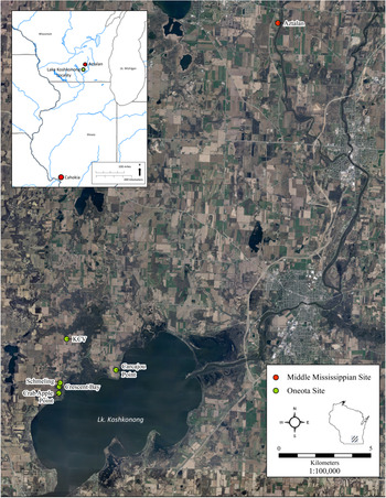
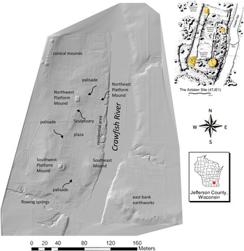
The transition from the first to second millennium AD represents the tail end of the Woodland-era social systems in the North American midcontinent and the emergence of the first Mississippian societies. The heavily fortified Aztalan site (Figures 1 and 2), located on the Crawfish River in southeast Wisconsin, is considered especially significant during this time because it represents the northernmost large, multi-mound center recorded with substantial Late Woodland (AD 400–1000) and Middle Mississippian (AD 1000–1500) components (Barrett Reference Barrett1933; Birmingham and Goldstein Reference Birmingham and Goldstein2005; Richards Reference Richards, McNutt and Parish2020). Aztalan's site structure is dominated by three platform mounds and a modified natural knoll—now considered to have functioned as a fourth platform mound (Goldstein Reference Goldstein2015)—situated in each corner of an 8.5 ha area that is enclosed by a rectangular, bastioned palisade (Richards and Zych Reference Richards, Zych, Koldehoff and Pauketat2018). In addition to the earthworks, the enclosed area included a central plaza and a residential area. Prior to European settlement, a minimum of 70 conical, linear effigy mounds were present within about a half-kilometer radius of the site (Lapham Reference Lapham1855; Figures 1 and 2). Chronologically diagnostic ceramics from Aztalan suggest that Mississippians first joined the Late Woodland community in the latter half of the eleventh century AD (Hall Reference Hall1962; Richards Reference Richards1992, Reference Richards2003, Reference Richards2007, Reference Richards, McNutt and Parish2020; Richards and Jeske Reference Richards and Jeske2002), and numerous vessels have been identified at Aztalan that closely correspond to the Lohmann and Stirling phase ceramics from the Cahokia site in the American Bottom (AD 1050–1200; Fortier et al. Reference Fortier, Emerson and McElrath2006). In addition, some of these pots were constructed from American Bottom pastes, whereas others appear to be local copies of Cahokian wares (Stoltman Reference Stoltman1991). Prior to the Mississippian presence at Aztalan, Collared Ware pottery from the base of a stratified midden suggests a date in the AD 900s–1000s for the formation of the Late Woodland community (Richards Reference Richards1992).
Locations of Aztalan and Oneota sites around Lake Koshkonong.

Map of the Aztalan Site (47JE1): (a) lidar image of Aztalan site showing major extant features (after Richards and Zych Reference Richards, Zych, Koldehoff and Pauketat2018); (b) artist's reconstruction of Aztalan site plan (after Palson Reference Palson1982), shaded areas on inset identify mound locations; (c) location of Jefferson County in Wisconsin.

Carpiaux (Reference Carpiaux2018), Edwards (Reference Edwards2017), Jeske and colleagues (Reference Jeske2020), Schneider (Reference Schneider2015), and Sterner (Reference Sterner2018) have recently published 24 radiocarbon measurements (compiled in Supplemental Table 1) from Oneota period (AD 900–1650) settlements that suggest that the Mississippian occupation at Aztalan may have been contemporaneous with Oneota populations at Lake Koshkonong, approximately 15 km (25 river km) downstream from Aztalan (Figure 1). This locality consists of a 25 km2 area along the northwest shore of Lake Koshkonong, with five dated Oneota village settlements and a number of smaller special-purpose or seasonal sites (Jeske et al. Reference Jeske, Sterner and Edwards2020). Chronological study of Aztalan has primarily relied on a relative artifact chronology that closely follows the American Bottom's to determine the timing and temporality of the village, and no clearly diagnostic Oneota ceramics have been identified at Aztalan. Given that there is minimal overlap between Mississippian and Oneota ceramic forms, the use of ceramic seriation alone has proven to be difficult for accurately and precisely deciphering the temporal relationships between Mississippian occupations at Aztalan and Oneota settlements at Lake Koshkonong.
In this article, we present new radiocarbon results and use Bayesian chronological modeling incorporating the radiocarbon data to suggest a settlement history for the Late Woodland and Mississippian presence at Aztalan and the Oneota presence at Lake Koshkonong. This work corresponds to several recent studies that have used Bayesian techniques to provide high-precision chronologies for archaeological sites in the North American midcontinent (Emerson et al. Reference Emerson, Emerson, Hedman and Fort2019; Krus et al. Reference Krus, Cook and Hamilton2015, Reference Krus, Herrmann, Pike, Monaghan and Wilson2019). More broadly, this follows archaeological work abroad that applies Bayesian techniques to establish probabilistic chronological frameworks for the timing and duration of individual archaeological occupations and regions (Bayliss Reference Bayliss2015; Hamilton and Krus Reference Hamilton and Krus2018).
The calibrations for these recent radiocarbon dates suggest that the Aztalan-Koshkonong area may have contained contemporaneous Oneota and Mississippian communities within a close vicinity by the AD 1100s (Supplemental Table 1). Similar close neighborings between the Oneota and Mississippians were more common by the AD 1300s as Oneota populations expanded in the southern midcontinent to inhabit areas previously occupied by Middle Mississippians (Edwards et al. Reference Edwards, Jeske and Coltrain2017; Esarey and Conrad Reference Esarey and Conrad1998; Gibbon Reference Gibbon1986; Steadman Reference Steadman1998). These population relocations may be linked to the ecologically driven challenges and opportunities that northern Oneota and Middle Mississippian farmers faced during the end of the Medieval Climate Anomaly in the AD 1100s–1200s (Bird et al. Reference Bird, Wilson, Gilhooly, Steinman and Stamps2017); however, the exact timing and tempo of these large-scale population changes have yet to be assessed through chronological modeling methods.
Additionally, synoptic climatological modeling of multiple localities in southern Wisconsin (Bryson Reference Bryson and Oliver2005; McEnaney and Bryson Reference McEnaney and Bryson2005) suggest that the chronologies and settlement patterns do not correlate well with expectations based on climate change (Jeske and Edwards Reference Jeske and Edwards2012). Although there were localized variations through time, mean January low temperatures, mean July high temperatures, mean precipitation, and mean available water were all on a steep decline at the end of the AD 900s, with the available water beginning to rise around the AD 1300s (Edwards Reference Edwards2020a). Yet, Aztalan was occupied for centuries during this decline, both before and after the use of intensive maize agriculture (Zych and Richards Reference Zych, Richards, Cook and Comstock2021, in press). Maize-dependent Oneota groups also appear at Lake Koshkonong during this period, and the region was not abandoned until several generations after temperatures and available water began to increase (Edwards Reference Edwards2020a; Jeske et al. Reference Jeske, Sterner and Edwards2020). Social and cultural factors (e.g., technology, as well as political, religious, economic relationships) work to smooth out year-to-year fluctuations in climatic-related weather conditions (Edwards Reference Edwards2020a). Zych and Richards (Reference Zych, Richards, Cook and Comstock2021, in press) use the Palmer Drought Severity Index for southern and western Wisconsin and come to similar conclusions for Aztalan and several other Middle Mississippian sites in the Mississippi River Valley: “our data at present lend little support to climatic factors operating as key push or pull forces bringing Cahokian settlers into the western Great Lakes.” Emerson and colleagues (Reference Emerson, Hedman, Fort, Emerson, Cook and Comstock2021) make a similar argument for the emergence and movement of Fisher, Huber, and Langford archaeological cultures in northeastern Illinois.
Previous Bayesian chronological work presented by Krus (Reference Krus2016) suggested that the Aztalan palisade is the oldest with bastions in the Mississippian world, possibly all of North America (Keeley et al. Reference Keeley, Fontana and Quick2007; Krus et al. Reference Krus, Herrmann, Pike, Monaghan and Wilson2019). Palisades with bastions provide evidence for the militarization of Mississippian settlements, in part due to the strategic placement of bastions at regular intervals to shield the visibility of archers and to increase their line of sight (Keeley Reference Keeley1996:56). This architectural form would later surround most of the largest Mississippian and Plains Village social centers (Johnson Reference Johnson2007; Milner et al. Reference Milner, Chaplin and Zavodny2013). The palisades at Aztalan also include interconnected inner-palisade walls (Figure 2), which both Barrett (Reference Barrett1933:51–53) and Richards (Reference Richards1992) suggest may have functioned to divide the site into distinct areas or screen some activities from general view; however, the contemporaneity of the various palisade systems at Aztalan remains unclear (Schroeder and Goldstein Reference Schroeder, Goldstein and Goldstein2015).
Poor skeletal health and skeletal trauma documented at Aztalan (Anderson Reference Anderson1994; Rudolph Reference Rudolph2009; Sullivan Reference Sullivan, Nelson and Kehoe1990) and the Lake Koshkonong Oneota settlements further suggest hostility in this area during Aztalan's Mississippian occupation (Foley Winkler Reference Foley Winkler2011; Jeske Reference Jeske2020:107; Richards and Jeske Reference Richards and Jeske2002; Ritzenthaler Reference Ritzenthaler1958). The curated skeletal assemblage from Aztalan includes a minimum of 28 formal interments as well as incompletely reported collections of what Rudolph (Reference Rudolph2009:6) refers to as informal burials, “the scattered, isolated and processed human remains recovered from across the site.” The relatively high frequency of perimortem trauma indicators on bone from informal burials at Aztalan has historically been speculated to be the result of cannibalism (Barrett Reference Barrett1933; Holcomb Reference Holcomb1952), mortuary ritual (Goldstein Reference Goldstein, Sullivan and Mainfort2010; Goldstein and Sullivan Reference Goldstein and Sullivan1986), or intergroup hostilities (Birmingham and Eisenberg Reference Birmingham and Eisenberg2000; Birmingham and Goldstein Reference Birmingham and Goldstein2005; Richards and Jeske Reference Richards and Jeske2002; Sullivan Reference Sullivan, Nelson and Kehoe1990). Rudolph's Reference Rudolph2009 study has so far provided the only formal comparative analysis of these competing hypotheses, and it suggests that violence resulting from intergroup hostilities provides the most compelling explanation for the presence of perimortem trauma indicators in the human remains. Specifically, Rudolph's (Reference Rudolph2009) sample included three formal burials and 1,402 pieces of disarticulated human remains representing, in total, a minimum number of individuals ranging from 29 to 39 and a most likely number of individuals between 84 and 92. She documented a variety of perimortem processing indicators such as cut marks, chop marks, scalping, and fractures and noted that these were restricted to informal burials. Rudolph judged these indicators to be inconsistent with the practice of cannibalism and only weakly indicative of mortuary-related processing.
Whereas Foley Winkler's (Reference Foley Winkler2011) seminal work on Lake Koshkonong mortuary data indicated low levels of violence, new data have provided a different interpretation. Since 2011, a series of individuals with clear signs of interpersonal violence have been observed (e.g., embedded projectiles, cranial depression fractures). Approximately 36% of skeletons recovered from the Crescent Bay Hunt Club site in Lake Koshkonong demonstrate evidence for interpersonal Oneota violence (Jeske Reference Jeske2020; Jeske et al. Reference Jeske, Sterner, Strange, Edwards and Ahlrich2017). None of these individuals were removed from their site, and all were reburied in situ after analysis in the field. Compiling all known Oneota skeletal material recorded for the Koshkonong Locality, approximately 34% of individuals show at least limited evidence for perimortem trauma.
In addition to direct evidence of violence, subsistence and settlement patterns also provide support for intergroup hostilities in the region. Koshkonong Locality carbon and nitrogen stable isotope data, along with macrobotanical and zooarchaeological data, indicate a diet that was heavily dependent on maize agriculture and that had relatively low levels of meat and fish protein (Edwards Reference Edwards2017, Reference Edwards2020a; McTavish Reference McTavish2019, Reference McTavish2020). High levels of caries, abscesses, and linear enamel hypoplasia at several Koshkonong Locality sites indicate poor health and an inability to obtain necessary nutrients from an environmentally rich and diverse area (Foley Winkler Reference Foley Winkler2011; Karsten et al. Reference Karsten, Jeske, Edwards, Strange, Kubehl and Behm2019). In addition, all five excavated Lake Koshkonong Oneota sites have multigenerational and/or ossuary graves, as well as isolated skeletal material found within general site refuse or feature fill (Foley Winkler Reference Foley Winkler2011; Hall Reference Hall1962; Jeske Reference Jeske2020; Jeske et al. Reference Jeske, Sterner, Strange, Edwards and Ahlrich2017). These subsistence patterns, nutritional markers, and burial forms may be circumstantial evidence that groups are embedded in a perilous social landscape, narrowing their foraging territories as an adaptive response to the risk of raiding (Edwards Reference Edwards2020a, Reference Edwards2020b; McTavish Reference McTavish2019; Milner et al. Reference Milner, Anderson and Smith1991; VanDerwarker and Wilson Reference VanDerwarker, Wilson, VanDerwarker and Wilson2016).
Birmingham and Goldstein (Reference Birmingham and Goldstein2005:88) state that, based on food remains, “the people of Aztalan enjoyed a well-balanced and nourishing diet.” However, the relationship of health and violence at Aztalan remains an open question due to the lack of an analysis focused on health. If one relied only on archaeozoological and archaeobotanical evidence, one might also mistakenly imagine that Lake Koshkonong individuals also had few nutritional or health deficiencies. Nonetheless, although no single researcher has systematically reviewed the Aztalan skeletal assemblage for health-related indicators, a number of studies have included health-related data (see Anderson Reference Anderson1994; Birmingham and Goldstein Reference Birmingham and Goldstein2005; Goldstein and Sullivan Reference Goldstein and Sullivan1986; Holcomb Reference Holcomb1952; Rowe Reference Rowe1958; Rudolph Reference Rudolph2009; Sullivan Reference Sullivan, Nelson and Kehoe1990; Zejdlik Reference Zejdlik, Osterholtz, Baustian and Martin2014). For example, an analysis of a sample of human remains from Aztalan conducted by Norman Sullivan (Reference Sullivan, Nelson and Kehoe1990) found relatively high rates of porotic hyperostosis and dental caries, which are consistent with a population dependent on maize. Similarly, Anderson's more extensive 1994 study reported a variety of ailments, including porotic hyperostosis, dental caries, dental abscesses, periosteal reaction, healed fractures, arthritis, button osteoma, and unspecified lesions. Finally, Rudolph's (Reference Rudolph2009) comprehensive analysis of both formal and informal burials observed the same suite of pathologies, albeit at slightly lower rates. Consequently, available evidence suggests that the overall health of the Aztalan population could be characterized as subpar. In light of Sullivan's (Reference Sullivan, Nelson and Kehoe1990) and Rudolph's (Reference Rudolph2009) conclusions that indicators of intergroup hostilities are common within the Aztalan skeletal assemblage, it is reasonable to assume some degree of linkage between health and violence at Aztalan.
Unlike other contemporary cultural groups, both locally and regionally, there is no pattern of satellite camp sites that appear to be connected to the main occupation at Aztalan. The Bethesda Lutheran Home site, located 18 km from Aztalan on the Rock River, yielded 99 Lohmann Phase Mississippian sherds within three pit features, along with 993 Late Woodland sherds within 64 features. One feature containing Middle Mississippian pottery provided a radiocarbon date of “1030 A.D. ± 60” (Hendrickson Reference Hendrickson1996:17). No other Middle Mississippian sites have been found near Aztalan, despite multiple large-scale, systematic surveys of the region (Goldstein Reference Goldstein1991; Goldstein and Richards Reference Goldstein and Richards1991; Jeske Reference Jeske2020; Richards and Jeske Reference Richards and Jeske2002). It appears that there was no Middle Mississippian settlement pattern in southeastern Wisconsin. Aztalan was essentially an isolated, fortified village and mound center, potentially with a restricted presence on the surrounding cultural landscape.
Radiocarbon Sampling and Methodology
We estimate the chronology of activity at Aztalan and the Lake Koshkonong Locality's Oneota occupation through the Bayesian chronological modeling of both radiocarbon data and relative dating information provided by stratigraphy and feature groupings. Advances in the Bayesian statistical modeling of radiocarbon dates and archaeological data have allowed researchers to understand site chronologies at human generational scales (Bayliss Reference Bayliss2009, Reference Bayliss2015; Bayliss et al. Reference Bayliss, Ramsey, van der Plicht and Whittle2007, Reference Bayliss, Van der Plicht, Ramsey, McCormac, Healy, Whittle, Whittle, Healy and Bayliss2011; Whittle Reference Whittle2018). Over the past 20 years, the number of radiocarbon measurements from archaeological samples procured from the Aztalan–Lake Koshkonong area has increased from 41 to 120 (Supplemental Table 1). Our main purpose for evaluating and modeling this absolute chronological data is to (1) historically contextualize Aztalan and the Lake Koshkonong Locality's Oneota occupations; (2) better understand the relationships between Late Woodland, Mississippian, and Oneota populations in this area; and (3) estimate a history for the formation and abandonment of the villages within the Aztalan–Lake Koshkonong area. The posterior probabilities derived from Bayesian chronological models for the timing of activity at Aztalan and the Lake Koshkonong Locality's Oneota occupations address these research goals directly.
The radiocarbon measurements from Aztalan and Lake Koshkonong's Oneota occupations have been previously published in 33 separate sources (primarily in reports, theses, and conference presentations), and this data is compiled in Supplemental Table 1. Submitters of these radiocarbon measurements were contacted to verify details not in the original sources for the compilation of the supplemental table, such as conventional radiocarbon ages and δ13C values. At Aztalan, 14 radiocarbon measurements have been taken from wood (either charred or uncharred), 16 from unidentified charcoal samples, nine from samples of maize, nine from other short-lived plants (such as nuts), four from animal bone, and 16 from charred cooking residues adhering to the interior surfaces and rims of ceramic vessels. For the Oneota settlements in the Koshkonong Locality, four radiocarbon measurements have been taken from wood charcoal, 10 from unidentified charcoal samples, five from samples of maize, six from other short-lived plants (such as nuts), three from animal bone, and 24 from charred cooking residues adhering to the interior surfaces and rims of ceramic vessels.
Twenty-five of these measurements are from bulk samples submitted between 1950 and 1990 to either the University of Michigan, the University of Wisconsin, or Dicarb Radioisotope laboratories, and they were measured following conventional methods (Bender et al. Reference Bender, Bryson and Baereis1966, Reference Bender, Bryson and Baereis1967, Reference Bender, Bryson and Baereis1970, Reference Bender, Bryson and Baereis1973; Crane and Griffin Reference Crane and Griffin1959, Reference Crane and Griffin1962; Richards Reference Richards1985, Reference Richards1992; Spector Reference Spector1975). Ninety-five of the measurements are from single-entity samples, and they were submitted to either the University of Arizona, the University of Georgia, the Illinois Geological Survey, Beta Analytic, or Direct AMS for accelerator mass spectrometry radiocarbon dating (Edwards et al. Reference Edwards, Jeske and Coltrain2017; Hart et al. Reference Hart, Lovis, Jeske and Richards2012; Hawley et al. Reference Hawley, Schroeder and Widga2020; Jeske Reference Jeske and Jeske2001, Reference Jeske2003; Jeske et al. Reference Jeske, Sterner and Edwards2020; Krus Reference Krus2016; Price et al. Reference Price, Burton and Stoltman2007; Richards and Jeske Reference Richards and Jeske2002, Reference Richards and Jeske2015; Richards et al. Reference Richards, Richards and Nicholls1998).
Supplemental Table 1 presents conventional radiocarbon ages and associated information for each radiocarbon measurement. Calibrated date ranges in modeling were calculated using the terrestrial calibration curve of Reimer and colleagues (Reference Reimer, Austin, Bard, Bayliss, Blackwell, Ramsey and Butzin2020) and OxCal v4.4. Bayesian chronological modeling was applied with the program OxCal v4.4, which utilizes Markov Chain Monte Carlo sampling techniques (Bronk Ramsey Reference Bronk Ramsey2009a). Each model uses a single set of Boundaries to structure the radiocarbon measurements as being from discrete periods of activity through the application of a uniform prior across each Bounded Phase. The uniform prior distributions underlying the models assume that events in each model are equally likely to have occurred in any individual year covered by the data (Bronk Ramsey Reference Bronk Ramsey1998:470). The Amodel agreement indexes calculated by OxCal are used to evaluate the fit between the OxCal model and data, with values ≥60 indicative of good agreement (Bronk Ramsey Reference Bronk Ramsey2009a). The posterior density estimates from OxCal are presented as probability ranges with end points rounded to the nearest five years. The OxCal model structures can be derived from the model descriptions and OxCal code (see Supplemental Texts 1 and 2). Importantly, the posterior density estimates produced by modeling are not absolute, and they will change with the incorporation of future data and/or if modeled from a different perspective.
Results
The structures of the Bayesian chronological models created in OxCal for Aztalan and each Lake Koshkonong site are fully described in Supplemental Texts 1 and 2, and the codes for each model are provided in Supplemental Text 2. The archaeological contexts of each radiocarbon sample, chronological hygiene considerations, and the documented stratigraphic relationships between these samples are described in Supplemental Table 1 and Supplemental Text 1. Models for the Crabapple Point and Schmeling archaeological sites are not provided because only a total of four radiocarbon measurements are available from these two sites. Additionally, a regional model was created for Oneota activity at Lake Koshkonong due to the low radiocarbon sample sizes for several of the modeled sites. This regional chronological model incorporates all of the radiocarbon measurements from Lake Koshkonong's Oneota occupations (Supplemental Texts 1 and 2).
Charcoal outlier modeling in OxCal was used in all the chronological models to account for unknown inherent age offset in wood charcoal samples (Bronk Ramsey Reference Bronk Ramsey2009b). This outlier modeling assumes an exponential distribution, with an exponential constant τ of 1 taken over the range −10 to 0, of the charcoal dates (following Bronk Ramsey [Reference Bronk Ramsey2009b] and OxCal 4.4's default settings for Charcoal Outlier modeling). The shifts are then scaled by a common factor that can lie anywhere between 1 and 1,000 years. Noncharcoal radiocarbon measurements were given a prior probability of 5% of being statistical outliers, using the General Outlier Model.
The Amodel agreement values are greater than 60 for all of the models presented in this article, suggesting good overall agreement between the radiocarbon dates and the assumptions of the models (Supplemental Text 1). It should be noted, however, that OxCal's Charcoal Outlier algorithm iteratively downweighs the impact of wayward results until the model runs freely and consistently, irrespective of the overlap integral between the posterior results and standardized likelihoods (i.e., the agreement; Bronk Ramsey Reference Bronk Ramsey2009b; Dee and Bronk Ramsey Reference Dee and Ramsey2014; Krus et al. Reference Krus, Herrmann, Pike, Monaghan and Wilson2019).
A sensitivity analysis was employed through creating alternate versions of each chronological model. Specifically, radiocarbon measurements from charred cooking residues adhering to ceramics were treated as termini post quos (TPQ) in the alternative models due to their inconsistency with the rest of the regional radiocarbon dataset (see Supplemental Table 1). These alternative models were created because some of the measurements from charred cooking residues are significantly older (>100 years cal AD) than the rest of the radiocarbon dataset (Supplemental Table 1; Supplemental Text 1). It is unclear exactly why some of these charred cooking residues measurements are too-old outliers, and possibilities include (1) the cooking of migratory fowl that had consumed marine organisms, (2) the cooking of foods that contained unassessed local freshwater reservoir effects (FRE), or (3) the incorporation of carbon in residues from old wood transfusion during the cooking process (Bonsall et al. Reference Bonsall, Cook, Manson and Sanderson2002; Olsen et al. Reference Olsen, Heinemeier, Hornstrup, Bennike and Thrane2013; Snoeck et al. Reference Snoeck, Brock and Schulting2014; Thompson and Krus Reference Thompson and Krus2018). The most likely possibility is contamination from old wood potentially due to undetected soot extracted during the residue collection process. Stable isotope and zooarchaeological data from these sites indicate that fish and/or migratory fowl composed no more than approximately 5%–10% of the human population's diet (Edwards Reference Edwards2020a; Jeske et al. Reference Jeske, Sterner and Edwards2020:22–23; McTavish Reference McTavish2019), which suggests that a FRE is not skewing the dates. Other than modeling radiocarbon measurements from charred residues as TPQ, the alternate models are identical to the primary models (Supplemental Texts 1 and 2).
Discussion
The Bayesian chronological models provide posterior probabilities for the start and end of activity at Aztalan, each Oneota site in the Lake Koshkonong Locality, and the entirety of Lake Koshkonong's Oneota occupations at the regional scale (Figures 3 and 4; Tables 1 and 2). Tables 1 and 2 and Supplemental Text 1 present the full details of the posterior probabilities estimated from chronological modeling. The models produced for sensitivity analysis yield similar results to the primary models at 95% probability, which suggests that the inclusion of measurements from charred cooking residues adhering to ceramics does not necessarily have a powerful impact on the modeling results. The most notable differences found in the sensitivity analysis at 68% probability are that (1) the posterior probability for the start of activity at Aztalan is cal AD 955–990 in the primary model and cal AD 985–1025 in the alternate model; and (2) the posterior probability for the start of activity at Lake Koshkonong's Oneota occupations is cal AD 1110–1150 in the primary model and cal AD 1155–1220 in the alternate model (Table 1). Future chronological work could potentially resolve the differences highlighted by the sensitivity analysis at 68% probability, but it should be emphasized that the results of the primary and alternate models are very similar other than these differences at 68% probability (Tables 1 and 2). Although the primary model results are feasible, the alternate models are preferred for interpretation because they offer a slightly more conservative treatment of the radiocarbon data than the primary models.
Posterior probabilities for the estimated start and end dates of occupation and palisade construction from the Bayesian models.

Posterior probabilities for the estimated time spans from the Bayesian models used to interpret the late precolumbian occupation history of the Aztalan–Lake Koshkonong area.

Posterior Probabilities from the Bayesian Models for the Estimated Start and End Dates for Discrete Occupations and the Aztalan Palisade Use Life.

Note: All dates are in cal AD with end points rounded to the nearest five years.
Posterior Probabilities from the Bayesian Models for the Estimated Spans for Discrete Occupations and Use Life of the Aztalan Palisade.

Note: All dates are in cal years with end points rounded to the nearest five years.
At 95% probability, the alternate model for Aztalan estimates that the Kekoskee Phase Late Woodland village formation occurred in cal AD 960–1105 (cal AD 985–1025, 68% probability) and that the Middle Mississippian abandonment occurred in cal AD 1235–1320 (cal AD 1255–1300, 68% probability), with the occupation of the village spanning 145–345 years (235–310 years, 68% probability; Figures 3 and 4; Tables 1 and 2). The models for the Oneota settlement chronologies are more variable and estimate that Oneota activity likely began at each site at different points during Aztalan's occupation (Figure 3; Table 1). Due to the imprecision of the site-level Oneota models (Tables 1 and 2), the regional model for Lake Koshkonong's Oneota occupations is preferred for comparison to the Aztalan chronology. At 95% probability the alternate model for Lake Koshkonong's Oneota occupation estimates that the region's Oneota occupation began in cal AD 1110–1255 (cal AD 1155–1220, 68% probability) and ended in cal AD 1395–1475 (cal AD 1410–1445, 68% probability), spanning 160–340 years (200–280 years, 68% probability; Figures 3 and 4; Tables 1 and 2).
Matrices comparing the posterior probabilities for the start and end of activity at Aztalan and Lake Koshkonong's Oneota occupations were created to best determine the order of major regional chronological events (Tables 3 and 4). There is a >99% probability that Kekoskee Phase occupation at Aztalan began before the start of Lake Koshkonong's Oneota occupations, a >99% probability of overlap between the occupation at Aztalan and Lake Koshkonong's Oneota occupations, and a 100% probability that Lake Koshkonong's Oneota occupations continued after the Middle Mississippian abandonment of Aztalan. Examining the estimated differences in these posterior probabilities indicates that Aztalan's Middle Mississippian occupation overlapped with Lake Koshkonong's Oneota occupations by at least 10–190 years (95% probability; Figure 4; Table 2) and probably 45–130 years (68% probability), suggesting multigenerational regional overlap between Middle Mississippian and Oneota populations.
Probability Matrix That Event τ1 Occurred before Event τ2 in the Primary Models.

Note: Probability matrix produced using OxCal's Order function on the corresponding posterior probabilities from the primary models.
Probability Matrix That Event τ1 Occurred before Event τ2 in the Alternate Models.

Note: Probability matrix produced using OxCal's Order function on the corresponding posterior probabilities from the alternate models.
Multiethnic interaction, or lack thereof, between Mississippian and Oneota communities may provide some insight into the genesis of militarization in the North American midcontinent. Specifically, this modeling indicates that the palisade at Aztalan existed in a multiethnic landscape that contained the Lake Koshkonong Oneota communities at an approximately five-hour distance either by water or over land (Jeske Reference Jeske2020). Additionally, numerous Effigy Mound and collared-ware Late Woodland sites were occupied within that same 25 km catchment (Goldstein Reference Goldstein1991; Richards and Jeske Reference Richards and Jeske2002). The act of building a bastioned palisade at Aztalan must have been quite novel in precolumbian communities at the start of the second millennium AD, and this modeling reconfirms that Aztalan's palisade is the earliest known with bastions in the Mississippian world (Keeley et al. Reference Keeley, Fontana and Quick2007; Krus et al. Reference Krus, Herrmann, Pike, Monaghan and Wilson2019). Specifically, modeling from this study estimates that the palisade at Aztalan was constructed in cal AD 1040–1160 (95% probability; Figure 3; Table 1), probably in cal AD 1050–1125 (68% probability). For context, the second earliest directly dated palisade with bastions in the Mississippian world is located at the Lawrenz Gun Club site in Illinois, and it was constructed in cal AD 1150–1230 (95% probability; Krus et al. Reference Krus, Herrmann, Pike, Monaghan and Wilson2019), possibly decades after the first palisade construction at Aztalan.
Aztalan's palisade is the most physically dominant feature of the site's ancient built environment, but chronological modeling suggests that the feature was not present during the initial decades of village occupation. The difference in posterior probabilities for the start of activity at Aztalan and for palisade construction indicates that Kekoskee Phase Aztalan was occupied for at least 10–155 years prior to the construction of the palisade (95% probability; Table 2) and likely 35–115 years (68% probability). Although the establishment of competing Oneota communities in Lake Koshkonong is one possible catalyst for palisade construction at Aztalan, another possibility might be related to the establishment of Middle Mississippian culture at the village. The earliest radiocarbon dates from Aztalan associated with Mississippian ceramics and/or archaeological contexts with Mississippian diagnostics are DIC–3133 (wood charcoal directly above a context containing shell-tempered pottery), ISGS-A1247 (charred cooking residue from a shell-tempered body sherd), and ISGS-A1252 (charred cooking residue from a Ramey Incised sherd). All three of these earlier radiocarbon measurements have somewhat imprecise posterior probabilities for calibration at 68% probability (cal AD 1035–1170, cal AD 1035–1150, and cal AD 1050–1210, respectively), making it difficult to identify the adoption of Middle Mississippian culture at Aztalan securely, but these probabilities do overlap tightly with palisade construction at the site (cal AD 1050–1125, 68% probability).
The chronological models also suggest that Aztalan's palisade was actively maintained for 85–235 years (95% probability; Figure 3; Table 2), probably at least for a century (130–215 years, 68% probability), suggesting that the village inhabitants maintained a defensive posture throughout the Mississippian occupation. Mississippian palisades with bastions were often used across human generations and were subject to ambitious renovations and intensive repairs to prevent decay and weathering (Krus Reference Krus2016). The anticipation of attack from Lake Koshkonong's Oneota populations may have served as an incentive for the inhabitants of Aztalan to maintain their palisade regularly in the AD 1100s–1200s. One note of caution, however, is that although the Oneota sites at Lake Koshkonong do appear to have been placed in defensive locations and yield skeletal evidence for interpersonal violence, none of the occupations provide direct material evidence for conflict with Aztalan itself (Jeske Reference Jeske2020). Likewise, material culture indicators of Oneota raiding or warfare at Aztalan have thus far eluded investigators. Part of this problem is that the single most diagnostic indicator of either group is the ceramic cooking pot. Unfortunately, these artifacts are unlikely to have traveled with raiding parties of either group. Conversely, we would expect lithic arrow points used at both Aztalan and Koshkonong Oneota sites to have been exchanged if these groups had been at odds. Although arrow points used by Middle Mississippians and Oneota populations were generally triangular points that are very similar, there are some differences between them. Aztalan triangulars are very often made of Hixton Quartzite (Birmingham and Goldstein Reference Birmingham and Goldstein2005:91); 47% of Madison triangular points recovered from the University of Wisconsin–Milwaukee (UWM) excavations at Aztalan are made of quartzite (Vander Heiden Reference Vander Heiden2018:46). It is also useful to note that notched triangular Cahokia points are common at Aztalan (Birmingham and Goldstein Reference Birmingham and Goldstein2005:91). However, neither Cahokia points nor quartzite triangular points have been recovered from excavated Lake Koshkonong Oneota sites to date (Hall Reference Hall1962:37; Sterner Reference Sterner2018; Wilson Reference Wilson2016). Although Birmingham and Goldstein (Reference Birmingham and Goldstein2005:91) suggest that Cahokian points were not used for war, the lack of Cahokia-style and quartzite triangulars at Oneota sites indicate that there was little to no exchange of projectiles between Aztalan and Lake Koshkonong Oneota groups for any reason.
Descriptions of Aztalan by early nineteenth-century visitors documented extensive earthen berms up to 1.5 m high and about 7 m wide paralleling the perimeter of the former palisade. Reports suggest that these berms were composed of high volumes of “Aztalan Brick”—the clay daub that once covered the palisade walls and was subsequently transformed into a low-grade ceramic when the palisade burned (Lapham Reference Lapham1855; Richards Reference Richards2007). Subsequently, the archaeological excavations at Aztalan from 1919 to 1932 led by S. A. Barrett documented large chunks of this “Aztalan brick” along the surface throughout the palisaded portions of the site, further supporting the notion that large sections of the structure were covered with clay and that a tremendous amount of labor went into coating both the exterior and interior walls. The defensive nature of these fortifications was also noted by Robert Lafferty (Reference Lafferty1973), who reviewed the evidence for 211 Late Woodland and Mississippian palisaded sites in the midcontinent. According to Lafferty's analysis, Aztalan appeared to be the most heavily fortified Mississippian site in North America (Lafferty Reference Lafferty1973:128). Conversely, although a number of Kekoskee sites appear to have been fortified by palisades (Salkin Reference Salkin, Emerson, McElrath and Fortier2000), none of the Oneota or Kekoskee Late Woodland sites that may have been coeval with Aztalan have yielded indications that they were surrounded by bastioned palisades.
The final activity associated with the palisade at Aztalan is estimated to have occurred in cal AD 1225–1295 (95% probability; Figure 3; Table 1), probably in cal AD 1230–1290 (68% probability), and this date provides the best estimate of the exact end of maintenance and repairs to the palisade. Palisades with diagnostic artifacts dating to the AD 1100s have been noted at other settlements in the northern hinterlands of the North American midcontinent (Delaney-Rivera Reference Delaney-Rivera2004; Finney Reference Finney2000; Finney and Stoltman Reference Finney, Stoltman and Stoltman1991; Milner Reference Milner1999; Milner et al. Reference Milner, Chaplin and Zavodny2013:Figure 2; Salkin Reference Salkin, Emerson, McElrath and Fortier2000:530), and it may be that palisades in these nearby areas also represent attempts by northern Mississippian communities to obtain symbolic and physical power in a contested landscape. Although Aztalan is the only known Mississippian site with a directly dated bastioned palisade likely constructed before AD 1150, by AD 1200–1300 bastioned palisades were in use at many additional fortified Mississippian centers (Krus Reference Krus2016; Krus and Cobb Reference Krus and Cobb2018; Krus et al. Reference Krus, Herrmann, Pike, Monaghan and Wilson2019). This sociopolitical instability and enhanced security in the greater Mississippian world may be related to the decreased summer precipitation at the end of the Medieval Climate Anomaly, which is believed to have caused declines in crop production and increased food scarcity (Bird et al. Reference Bird, Wilson, Gilhooly, Steinman and Stamps2017; Milner Reference Milner, Chacon and Mendoza2007; Milner et al. Reference Milner, Chaplin and Zavodny2013). Although the spread of Oneota populations is not well understood chronologically, by around AD 1300, these people appear to have spread across the upper midcontinent while likely persisting in the Lake Koshkonong Locality until the early or mid–AD 1400s (Edwards et al. Reference Edwards, Jeske and Coltrain2017; Esarey and Conrad Reference Esarey and Conrad1998; Gibbon Reference Gibbon1986; Jeske et al. Reference Jeske, Sterner and Edwards2020; Steadman Reference Steadman1998).
Conclusion
In this article, we have estimated a chronology for the Aztalan site, as well as the Oneota settlements in the nearby Lake Koshkonong locality. Although our results do not greatly alter the notion that Aztalan's Mississippian occupation lasted from approximately AD 1000 to 1250 (Richards and Jeske Reference Richards and Jeske2002), they do strengthen this viewpoint while providing further insight into the region's Late Woodland and Oneota chronologies. Specifically, this analysis suggests that Aztalan was founded as a Kekoskee Phase Late Woodland village in cal AD 985–1025 (68% probability; Figure 3; Table 1). The palisade was constructed at Aztalan in cal AD 1050–1125 (68% probability; Figure 3; Table 1), around the same time as the earliest directly dated evidence for a Middle Mississippian presence in the village. Oneota occupations were underway in the Koshkonong Locality by cal AD 1155–1220 (68% probability; Figure 3; Table 1). After 45–130 years of overlap with the Koshkonong Locality's Oneota occupations, the Mississippian abandonment at Aztalan occurred in cal AD 1255–1300 (68% probability, Figures 3 and 4; Tables 1 and 2). Oneota occupations in the Lake Koshkonong Locality sites continued after Aztalan's abandonment (Tables 3 and 4), likely ceasing in cal AD 1410–1445 (68% probability; Figure 3; Table 1). This research raises many questions, such as, Why is there a lack of material exchange between Aztalan and Lake Koshkonong's Oneota communities? Why did Mississippians vacate Aztalan while the Oneota occupations at Lake Koshkonong continued? Edwards (Reference Edwards2020a:154–155) indicates that although both groups were reliant on maize, Aztalan occupants were more heavily dependent on cultigens (e.g., maize, Eastern Agricultural Complex plants), whereas Koshkonong Locality Oneota subsistence included higher proportions of acorn and wild rice. Did these choices make Oneota subsistence practices more flexible and resilient than the Middle Mississippian subsistence regime?
The contemporaneity between the region's Mississippian and Oneota populations suggests that the Aztalan–Lake Koshkonong area was once a contested multiethnic landscape that served as the backdrop to the independent development of the palisade-with-bastions architectural form (Keeley et al. Reference Keeley, Fontana and Quick2007). However, the chronology presented here does not speak directly to the relationship between the Aztalan and the Koshkonong Oneota. Given the contemporaneity of the two communities, the defensive posture of the Oneota settlements, and the strongly fortified site of Aztalan, it is tempting to infer hostilities between the two groups. The lack of items signifying relations based on trade or exchange in the material culture inventory of either locale also supports this notion. Moreover, the high mortality rate among the Koshkonong Oneota and the evidence of conflict-sustained trauma observed in the Aztalan skeletal assemblage indicate that both locales experienced violent, armed conflicts. It is also likely that the threat of Oneota raiding at Aztalan preceded the actual movement of noncombatants to Lake Koshkonong, leading to the production of the bastioned palisade immediately prior to the establishment of Oneota villages. However, the identity of the combatants and even the locations of the encounters remains unclear. It is also worth considering that during the earliest part of the Aztalan-Oneota overlap, both Oneota and Mississippians were likely minority inhabitants of a region that had been a Late Woodland stronghold since at least AD 600 (Stoltman and Christiansen Reference Stoltman, Christiansen, Emerson, McElrath and Fortier2000). The presence of Late Woodland material culture indicators at Aztalan and their relative paucity at Koshkonong Oneota sites suggest that any reckoning of the Aztalan-Oneota relationship must also take into account the Late Woodland presence in the region.
Subsequent to Aztalan's abandonment, the periodicity of warfare was at chronic levels in the Mississippian world from AD 1200 to 1400 (Cobb and Giles Reference Cobb, Giles, Nielsen and Walker2009; Dye Reference Dye2008; Emerson Reference Emerson, Chacon and Mendoza2007; Krus Reference Krus2016; Milner Reference Milner1999, Reference Milner and Tracy2000, Reference Milner, Chacon and Mendoza2007; Milner et al. Reference Milner, Chaplin and Zavodny2013). In contrast, the palisade at Aztalan was likely constructed before AD 1150 (Figure 3; Table 1). To gain a better understanding of the dynamic social history of the northern portions of the North American midcontinent with higher precision and accuracy in the future, the late precolumbian settlements in southeastern Wisconsin require a more robust AMS radiocarbon dataset to further assess the ideas presented in this study and refine the region's multiethnic history. At the heart of this problem is the still unresolved relationship between the emergence of Oneota culture in southeast Wisconsin and the establishment of Aztalan as a new community incorporating aspects of both Late Woodland and Mississippian ontologies. Robert Hall's (Reference Hall1962:12) observation of almost 60 years ago that the “exact developmental relationship of Middle and Upper Mississippi culture in Wisconsin is a question afloat in countercurrents of opinion” remains as true today as when he wrote it.
Acknowledgments
Portions of this research have been funded by the UWM Research Grant Initiative. Field research used to collect some of the radiocarbon samples reported here was partially funded by the UWM College of Letters & Science and the UWM Cultural Research Management Program. Jeske would like to acknowledge the efforts of many graduate and undergraduate research partners as well as landowners such as the Crescent Bay Hunt Club, the Weisensel family, and Kevin Schmeling. Richards is particularly grateful for the support of the Wisconsin DNR, which directly funded a number of recent radiocarbon assays. The authors would like to also thank Lynne Goldstein for providing additional details about the analyzed radiocarbon data.
Data Availability Statement
This article is based on data from published sources and materials housed at the Archaeological Research Laboratory Center, University of Wisconsin-Milwaukee.
Supplemental Material
For supplemental material accompanying this article, visit https://doi.org/10.1017/aaq.2021.82.
Supplemental Text 1. Description of Bayesian Models and Results.
Supplemental Text 2. Code for OxCal Models.
Supplemental Table 1. Radiocarbon Data.