STAFFORDSHIRE
(1) Tamworth: 33 AE nummi of the House of Constantine to c. a.d. 335.Footnote 126
(2) Wall, Wall Hall, Green Lane (SK 09964 06645): a watching-brief during the construction of an orangery at Wall Hall on the site of the Neronian fort identified a single post-hole. Although undated, its size, profile and fill were similar to those of post-holes excavated in the Period 1 barrack blocks excavated in 1966/67.Footnote 127 The overlying subsoil horizon produced a greyware wide-mouthed jar of third- to fourth-century date.Footnote 128
SHROPSHIRE
(1) Pontsbury (area): three silver denarii, two Republican and one of Augustus (to a.d. 14).Footnote 129
(2) Telford (area): 24 Constantinian AE nummi to c. a.d. 340.Footnote 130
HEREFORDSHIRE
(1) Kington: three silver denarii are additions to a hoard that now totals 14 denarii to a.d. 122.Footnote 131
(2) Leominster: a hoard of 518 AE radiates deposited c. a.d. 290. This hoard is similar in composition to Normanby and likewise contains the earliest phases of both Carausian marked series, L and C. There was evidence that it had been contained within leather bag(s) since a number of surviving fragments of leather were preserved by copper alloy corrosion products.Footnote 132
WORCESTERSHIRE
(1) Hanbury, Vernon Arms, Saltway (SO 9650 6284): an evaluation took place on pasture land close to the line of the Saltway, a Romano-British trading route connecting the salt-producing town of Droitwich with Alcester and Ryknild Street. A series of ditches and a pit probably represent part of a Romano-British agricultural field-system, most likely associated with a nearby rural settlement. The small ceramic assemblage spans the second to fourth centuries a.d. A small piece of ceramic building material, fired clay and animal bone were also recovered.Footnote 133
(2) Hartlebury: 14 AE nummi to a.d. 324, with a composition very similar to that of the original find which also consisted of 14 nummi.Footnote 134
WARWICKSHIRE
(1) Alcester, Grammar School (SP 08655 57783): following an earlier evaluation, a watching-brief was maintained during the construction of a new classroom block adjacent to the site of Alcester Abbey.Footnote 135 Residual Severn Valley ware was recovered from later medieval contexts. The monitoring of service trenches from the new building to Birmingham Road identified a gravel surface and associated ditch that related to Ryknild Street. Previous work had identified this gravel road surface to the north; medieval pottery was found in the roadside ditch in 2005, suggesting that the road and ditch were still in use during the twelfth to thirteenth centuries. The recent excavation of the ditch produced both Severn Valley and samian ware sherds.
(2) Hillmorton, Ashlawn Road (SP 5220 7330): an evaluation on land to the south of Ashlawn Road revealed relatively shallow ditches and a number of isolated features such as pits and post-holes. Combined with geophysical survey results, the evidence indicates a sequence of Romano-British enclosures and field boundaries situated close to settlement activity. The ceramics span the Roman period, though second-century examples predominate. A small amount of metallic slag, flint and animal bone was also collected. Environmental remains are typical of the date and region.Footnote 136
(3) Warwick (area): a hoard of 30 silver denarii to a.d. 176.Footnote 137
LEICESTERSHIRE
(1) Burbage, land west of Workhouse Lane (SP 440 919): an evaluation identified several ditches, a pit and a post-hole focused on the centre of the development area. Whilst these features were largely undated, their similarity and proximity to others encountered during recent excavations on adjoining land suggest that they date to the early Roman (first or second century) period and represent field or stock boundary features. A possible roundhouse ditch and associated post-hole suggest settlement on the site during the Iron Age or early Roman period.Footnote 138
(2) Coalville, land south-east of Coalville (SK 347 120): evaluation of five areas subsequent to a geophysical survey revealed, in Area 4, an Iron Age sub-rectangular enclosure along with field boundaries dated to the Roman period.Footnote 139
(3) Donisthorpe, Acresford Road (SK 31138 13599): an evaluation showed a series of features identified by geophysical survey to be of second- to third-century date. They included a system of enclosures and field boundaries straddling a trackway. Quantities of artefactual material were small suggesting that the enclosures were located at a distance from settlement activity, although local greyware and Derbyshire products in the eastern enclosure ditches were associated with charred cereal processing and hearth waste. Settlement may thus lie east of the site.Footnote 140
(4) Higham on the Hill: (a) MIRA (SP 500 590): strip, plan and sample excavation and watching-brief were carried out during modifications to junctions of the A5.Footnote 141 Three areas were examined. A machine-excavated controlled area strip of the north side bell junction (Area 1) revealed a small number of archaeological features of late Roman date. (b) MIRA (SP 368 957): 51 evaluation trenches were excavated within Phase 1 of the proposed Business Technology Campus development located within arable fields. A discrete cluster of Roman roadside occupation adjacent to the A5/Watling Street contained a refuse pit with mid-first -century a.d. pottery. Three other trenches within the same area located boundary ditches, which may be associated with the pit.Footnote 142
(5) Hungarton, Village Farm, Baggrave Road (SK 6843 0765): Roman pottery of late first- to late second-century date was recovered from an electricity cable trench, close to a previously examined wind turbine location.Footnote 143
(6) Leicester (Ratae): (a) Bath Lane (SK 58002 04684): evaluation was undertaken in advance of redevelopment at Friars Mill, lying within the north-west quarter of the Roman and medieval walled town.Footnote 144 Two trenches were excavated, each containing deeply stratified layers overlying probable alluvial deposits. Trench 1, adjacent to the river Soar, had layers of mortar-rich soil overlying waterlogged deposits possibly reflecting filled ditches, or channels associated with the river. Trench 2, on the western side of the site, contained a thick layer of silty clay with some occupation debris, overlying what appeared to be layers of alluvium. No evidence was found for the defences of the walled Roman and medieval town.
(b) Bath Lane (SK 580 046): excavation on land bounded by All Saints Road, Bath Lane and Blackfriars Street revealed significant archaeological deposits dating from the Iron Age to the medieval periods, despite extensive later truncation.Footnote 145 The first Iron Age phase was represented by a series of shallow roughly parallel gullies, situated towards the south of the site, along with a low density of pitting, possibly representing agricultural activity. The second phase was represented by a large rectangular ditched enclosure with an entrance and three sides present within the excavated area, likely to be a continuation of, or associated with, Iron Age features previously identified during investigations at the Merlin Works site. This relationship was further evidenced by the copious quantities of clay coin-flan/pellet mould fragments, high quantities of local and imported fine ware pottery, animal bone and evidence of episodic industrial activity, a feature of the previous investigations. A total of 81 fragments of coin-mould were recovered, with two mould tray forms being identified. The first is the well-known ‘Verulamium’ form, which when complete was pentagonal and bore 50 holes in 7 rows of 7 plus a hole in the pedimental apex. This mould tray form has already been noted at the Merlin Works site, adjacent to the Blackfriars excavation. The form of the second tray is not certain, but it had no fewer than 8 rows and 6 columns, in common with the largest fragment found at Old Sleaford.
Within the enclosed area several shallow hearth/kiln bases were found. A series of large, contemporary late Iron Age pits and two structural gullies were located outside the enclosure, whilst a kiln-base possibly associated with the manufacture or use of the coin-flans was located immediately to the south. A single Iron Age coin, found with a Flavian coin in an early second-century a.d. deposit, also would appear to be associated with this Iron Age presence.
In the initial Romano-British occupation of the area the remnants of late Iron Age pits were deliberately backfilled with gravel to consolidate the ground before the construction of a series of shallow parallel agricultural or boundary ditches dated to the mid-first century a.d. The beamslots and post-hole foundations of at least three mid-first-century structures were noted. These were partially built over the backfilled Iron Age pits and the enclosure ditch. Use of the site for horticulture or agriculture was represented in the accumulation of a humic, silty horizon over the majority of the site with infrequent irregular pitting. This sealed and post-dated the initial Romano-British structures and appeared to have been formed during the later first and/or early second century a.d.
The first half of the second century a.d. saw the development of a metalled street with a complex of masonry structures fronting onto it. These structures had a large unroofed yard area to the rear with timber outbuildings seemingly used for industrial and metalworking activities. In the mid/late second century a.d. the masonry structures were expanded, extending into the course of the street. Contemporaneously, a failed attempt was made to convert the open rear yard into a basilica-like or aisled building, as evidenced by the insertion of masonry columns into the yard. These seem ultimately to have been utilised as a colonnade supporting a less substantial ‘cloister’ around a still open central yard. Localised areas of ground consolidation and floor surfaces associated with small-scale industrial activities were probably contemporary. A final phase of Romano-British industrial activity and substantial gravel quarrying within the yard was followed by apparent abandonment and structural collapse, as indicated by the roofing material and accumulation of a thin deposit of silts across the majority of the site. The majority of the Roman masonry walls and foundations were robbed in the medieval period.
(c) Jubilee Square (SK 583 044): a watching-brief revealed features of many periods, concentrated to the west of Carey's Close.Footnote 146 The Roman evidence included metalling of the Fosse Way road as it runs through the town to the south of the forum site. Either side of this road parallel wall-lines and roadside ditches were exposed. On the north side of the road further substantial walling of a type suggesting public works may be the south precinct wall of the forum insula, XXII. Adjacent to the south edge of the Fosse Way was the north-west corner of a stone building with associated floor make-ups. A ‘dark earth’ of Saxon or later date was also identified in some areas. Two fragments of Roman worked stone were recovered from residual contexts: a finely worked cornice fragment measuring 880 by 490 by 240 mm, and a column drum, dimensions 530 by 350 by 270 mm with a probable original diameter of 540 mm.
(d) 55 Oxford Street (SK 5856 0393): three evaluation trenches were excavated.Footnote 147 In Trench 1, on the northern side of the site, a mid/late second-century Roman ditch most likely formed part of a property extending east from the projected line of the Roman Tripontium road which should cross the site. It produced evidence for metalworking activity taking place in the immediate vicinity and one human bone found in the ditch fill may indicate that there are human burials nearby.
(7) Market Harborough, Waterfield Place (SP 7358 8834): excavation subsequent to geophysical survey and trial-trenching examined a multi-phase site, dating predominantly from the mid–late Iron Age but extending into the late first century a.d. A Roman small town has long been suspected to lie to the east of the site. The continuation of activity on the site into the early Roman period, coupled with a lack of later Roman material, therefore suggests that settlement shifted eastwards along the ridge. Saxon pottery was recovered from a small number of post-holes, towards the west of the site, but is not associated with large scale re-occupation.Footnote 148
(8) Rolleston, Stonton Catchment Project (SK 74324 00960): a watching-brief was maintained during the excavation of a series of eight wildlife ponds within a spring line combe. Roman pottery, roofing-tile and animal bone were recovered within colluvium from the combe sides at three of the pond locations. A rapid walk-over survey of the adjacent cultivated valley sides identified two potential scatters of Roman settlement debris on the northern and eastern slopes of the combe sides — the source for the material found within the colluvium excavated within the ponds.Footnote 149
RUTLAND
(1) Cottesmore, Rogues Lane (SK 9054 1392): evaluation revealed features including ditches, gullies, pits and a post-hole. Pottery and other material, including a kiln bar and a glass bead, were recovered. The evidence indicates domestic and perhaps industrial activity in the mid-first to second century a.d.Footnote 150
(2) Oakham: (a) Barleythorpe Road (SK 855 092): excavations revealed an extensive area of multi-period activity. The most intensive activity took place during the late Iron Age/transitional period, eventually declining or changing in nature in the first century a.d. The Iron Age/Roman site probably represents part of the same spread of settlement revealed during excavations at Catmose College to the north-westFootnote 151 and is comparable in type and development to other contemporary settlements in Rutland and Leicestershire. The small finds and environmental assemblages indicate that the inhabitants of the settlement were involved in mixed farming, but an emphasis on pastoralism is suggested. Evidence for metalworking and food processing was also recovered.Footnote 152
(b) Oakham School, Merton Building (SK 48602 30904): following an earlier evaluation an open area excavation identified an Iron Age cremation burial within a small shell-gritted jar, located in a small pit truncated by a narrow gully, containing a mixture of late Iron Age and Roman pottery. Residual Roman tile, including box-flue tile and tegulae, was recovered from later deposits, along with a copper-alloy globular-headed lock pin with a perforated shank.Footnote 153
NORTHAMPTONSHIRE
(1) Abthorpe, Handley Park solar farm (SP 6707 4605): evaluation identified the remains of a small Roman farmstead and an associated field-system. The finds included fragments of Roman roof-tile possibly suggesting the former presence of a Romanised building.Footnote 154
(2) Brixworth, Saxon Rise 2 (SP 7494 6939): evaluation recorded ditches, pits and a stone wall, probably a continuation of Iron Age and Roman settlement previously identified immediately to the north.Footnote 155
(3) Burton Latimer, land south of Higham Road (SP 904 738): evaluation identified a number of Roman pits and the limestone foundation of a circular building. The location and quality of construction of the building may indicate that it was a Romano-British temple: it displayed evidence of significant burning during its demolition. Finds from the demolition layer suggest that it had fallen out of use by the late third century a.d.Footnote 156
(4) Kings Cliffe: 2 silver denarii of Hadrian bring the total of this Antonine denarius hoard to 18 coins.Footnote 157
(5) Long Buckby, land west of Long Buckby (SP 6222 6701): excavation revealed evidence of an early Roman farmed landscape and associated settlement nearby, possibly to the west of the site. At least two phases of activity were identified, with the majority of the features, which included ditches, pits, a possible structure and an oven/cooking pit, dating to the mid/late first century a.d. to the early second century a.d. One of the ditches may possibly have continued in use into the second half of the second century.Footnote 158
(6) Old Stratford, Old Stratford to Kiln Farm water main (SP 7875 3964): evaluation along the route of a new water main identified an area of Romano-British remains consisting of ditches, gullies and pits. Early to mid-Roman pottery and lead artefacts from these features are indicative of relatively high status and possibly ritual activity in the vicinity.Footnote 159
(7) Raunds, Warth Park (SP 9833 7317): a 4-ha excavation and 3-ha watching-brief revealed evidence for activity spanning the late Neolithic through to the middle Saxon period. Roman features comprised a number of substantial post-holes and a pit group containing large amounts of pottery, including a complete samian bowl.Footnote 160
(8) Towcester, Wood Burcote Court (SP 697 473): the second phase of a trial-trench evaluation targeted on geophysical anomalies identified ditches possibly of Roman date, but all the Roman finds were residual in later contexts.Footnote 161
CAMBRIDGESHIRE
(1) Alconbury: (a) Enterprise Zone enabling works: construction of Boulevard Spur and Estate Road (TL 201 766): limited evaluation trenching revealed a buried soil dating to the Iron Age and Roman periods, in addition to a series of pits, post-holes and ring ditches of possible Iron Age date.Footnote 162 (b) Alconbury Weald (TL 2010 7660): an evaluation revealed late Iron Age settlement-related features comprising a single substantial post-hole, a rectangular pit and a system of field enclosure ditches, the latter aligned north-east to south-west.Footnote 163
(2) Bottisham, land at Crystal Park, Tunbridge Lane (TL 5452 6088): an evaluation identified a complex of settlement-related features in the form of boundary and drainage ditches, rubbish pits, clunch walls, floor layers and demolition deposits. The finds indicate both domestic and agricultural activity, with several hints of relatively high status, and comprised large quantities of animal bone, pottery of predominantly third- to fourth-century date, and ceramic building material which included tegula, floor tile and box-flue tile, suggesting the presence of a building with a hypocaust heating system in close proximity. The findings are in keeping with the results of previous excavations in this part of Bottisham, which have investigated the peripheral areas and infield enclosures of a Roman farmstead or possible villa. It is not yet clear whether the walls and associated deposits in the central area of this site represent part of the conjectured villa range or of outbuildings.Footnote 164
(3) Cambridge: (a) NCS Cambridge (TL 4613 5491): monitoring of 20 geotechnical trial pits on land immediately south of Addenbrooke's Hospital showed that several of the trial pits in the northern area contained Roman features, predominantly ditches, while a possible enclosure ditch of uncertain date was identified in the southern area.Footnote 165
(b) Land south of Bell Language School (TL 4672 5487): two excavation areas, totalling 2.37 ha, contained features ranging in date from the Bronze Age to the nineteenth century. Iron Age settlement features, including pits and ditches, were identified, in addition to a Roman field-system comprising numerous parallel cultivation ditches.Footnote 166
(c) Cambridge Biomedical Campus: The Circus & Piazza and Papworth Trust Sites (TL 46130 54914): open area excavation on land to the west of Addenbrooke's Hospital revealed an early Roman rectilinear field-system and a large area of cultivation beds of similar date. No areas of domestic occupation were found, presumably because this parcel of land was too wet. Areas of possible crop processing and metalworking were present, however, including several sub-square or sub-rectangular features located on the higher ground.Footnote 167
(d) Land at Aylesborough Close (TL 4486 6101): an evaluation identified part of a ditch-defined field-system dating from the first to the early third century. The finds assemblage from one of the ditches consisted of local coarse ware including an unusual sherd with a series of deliberate modifications to the internal surface of the vessel, consisting of two thumb impressions and two indentations made with a square-ended tool. Similarly modified vessels have previously been interpreted as pottery beehives, but use as a storage jar is also possible. The ditches appear to be on an alignment similar to extensive cropmark field-systems visible on aerial photographs of the area taken before the construction of the present housing estates, which were orientated broadly perpendicular to the south-west to north-east route of Roman Akeman Street.Footnote 168
(4) Cambridge to Huntingdon, A14 Cambridge to Huntingdon Improvement (TL 1700 7190, 3585 6565, 4700 6215): investigations revealed Romano-British field-systems and settlement activity in several areas along the route, including west of the A1, alongside Buckden Road to the east of the A1, and to the east of Conington Road. Notable discoveries include a pottery kiln.Footnote 169
(5) Christchurch: a hoard of 3 denarii, 18 copper-alloy sestertii and sestertius fractions and 411 copper-alloy (mostly barbarous) radiates deposited c. a.d. 285. While the presence of the earlier coin types in a hoard of barbarous radiates is unusual, the possibility that they belong to the hoard cannot be formally excluded.Footnote 170
(6) Doddington, Wimblington Road (TL 405 908): following geophysical survey which identified possible pits, an evaluation located ditches of a probable Roman field-system cut through earlier undated ditches, possibly part of a late Bronze Age or Iron Age field-system. Early to middle Saxon material was also recovered.Footnote 171
(7) Ely, Highfields Special School (TL 5386 8089): an evaluation identified a layer of buried soil containing late Iron Age and early Roman pottery.Footnote 172
(8) Godmanchester, Flood Alleviation Scheme (TL 2428 7114–TL 2435 7080): early Roman evidence was uncovered during excavation of the footings for the flood defence wall and dredging of the river. Although most of the foundations did not penetrate beneath garden soils and modern levelling deposits, stratified archaeological remains were uncovered at No. 4 The Avenue. These included late first-century a.d. layers overlain by a second-century occupation surface, two associated hearths and a compacted clay and gravel surface. A gravel road or track also uncovered at this property appeared to be running perpendicular to the suggested route of Roman Ermine Street. Over 300 sherds of Roman pottery were recovered, along with well-preserved environmental remains, including charred cereal grains and fish-scales, indicating intensive domestic occupation in this area until the early third century a.d.Footnote 173
(9) Great Shelford, Scotsdales, 120 Cambridge Road (TL 4560 5360): evaluation revealed a single ditch of probable Roman date at this site, which is located adjacent to extensive known Roman features.Footnote 174
(10) Haddenham, land at Wilberton Road (TL 4680 7480): in addition to prehistoric features, evaluation revealed a pit containing skeletal remains of a cow and a dog, along with the mandible of a sub-adult cow, located in a low-lying area in the southernmost field. An outlying Roman pit found close to the animal burial pit contained preserved spelt wheat. The main area of archaeological activity was focused around a sub-rectangular enclosure of late Iron Age or early Roman date in the northern and highest part of the site. An area at the southern end of the north field was found to have been very wet and evidence for water-lain deposits (alluvium and peat) was present here, along with boundary ditches that were probably associated with water management.Footnote 175
(11) Hemingford Grey, Innesfree, Mill Lane (TL 2953 7082): evaluation identified several ditches, a pit and a post-hole, all of late Iron Age and early Roman date, that almost certainly belong to an extensive cropmark site recorded in the field immediately to the east. Subsequent excavation uncovered a series of boundary or drainage ditches and pits, along with an assemblage of late Iron Age and early Roman pottery. The ditches were probably associated with a low-status settlement or farmstead that may have been relatively short-lived.Footnote 176
(12) March: (a) Job's Lane (TL 4153 9493): evaluation identified extensive inter-cutting stratified features, comprising ditches, pits, possible post-holes and a surfaced trackway, representing at least four phases of activity spanning the Iron Age and Roman periods.Footnote 177 (b) Estover Road (TL 4251 9813): evaluation targeting cropmarks and geophysical anomalies identified several ditches and possible settlement features tentatively dated to the Roman period in the west and the south of the site. A ring-ditch located towards the centre of the site may have been the remains of a roundhouse.Footnote 178
(13) Melbourn: (a) land east of New Road (TL 3884 4436): trenches targeted on geophysical and aerial photographic survey results revealed evidence of prehistoric and Roman activity, the latter including a possible beamslot, a ditch and a number of residual finds. An east to west trackway running through the middle of the site was possibly part of the Roman route of Ashwell Street.Footnote 179
(b) Muncey's Farm (TL 3774 4261): evaluation revealed evidence for Roman agricultural activity in the form of small ditches aligned roughly north to south. A trackway crossing the south of the area is visible on aerial images continuing west to Royston, where it probably joined Ermine Street.Footnote 180
(c) Land at Black Peak Farm (TL 405 441): the site's eastern boundary follows the Bran Ditch, a seventh-century a.d. earthwork crossing the zone of the Icknield Way. Evaluation following geophysical survey identified a zone of parallel early to middle Iron Age boundary and undated ditches positioned on the Bran Ditch's main (undeviated) line. The latter not only formed a boundary across the Icknield Way, but also a routeway towards the springs and wetlands by Black Peak and Fowlmere. In the north-west of the evaluation area was a series of early Iron Age enclosures and early Roman ditches associated with the springs. Two of the Iron Age ditches were recut in the early Roman period to form co-axial enclosures along the Romanised Ashwell Street, a route which also probably has prehistoric origins. Roman settlement persisted here into the fourth century and extended eastwards and northwards, towards the springs. A southerly branch from Ashwell Street, the Fowlmere Path, was also identified, meeting the Bran Ditch around the site of a known Saxon execution cemetery.Footnote 181
(d) Land Adjacent to Melbourn electricity substation (TL 3694 4374): two parallel ditches of probable Roman date were aligned north-west to south-east across the site and positioned perpendicular to the line of Ashwell Street Roman road, which forms the southern boundary of the site.Footnote 182
(14) Orwell, No. 13 Hurdleditch Road (TL 3568 4998): evaluation revealed a north–south-aligned ditch containing late Iron Age pottery and animal bone.Footnote 183
(15) Over, Norman Way Industrial Estate (TL 3790 6930): excavation uncovered relatively dense Roman remains in the north part of the site. The earliest phase consisted of a number of boundary ditches and pits presumably related to agricultural activity associated with an adjacent settlement. This was quickly followed by a phase of industrial activity located to the south-west of the ditches, represented by a small cluster of pits that contained charcoal-rich fills and slag indicative of metalworking in the vicinity. Following this, a large sub-rectangular watering-hole was dug, the fills of which also contained slag and daub. Features from the most intensive phase of activity included another watering-hole, a number of large intercutting sub-circular pits and a possible corn-drier, all of which contained large amounts of crop-processing waste.Footnote 184
(16) Sawston, land at Dale Manor Business Park, West Way, Babraham Road (NGR TL 4940 5080): an evaluation revealed evidence for a late Roman settlement overlain by a layer of dark earth. Features recorded included a series of boundary ditches demarcating enclosures and trackways, a number of pits, a post-hole and a well. A third-century east–west-aligned juvenile inhumation, furnished with a small greyware beaker and a miniature coarse ware jar, was also uncovered. It was positioned between two parallel ditch sections which may represent a curvilinear ditch. Also of interest was a partial articulated animal burial within the upper fill of the well as it may reflect ‘ritual’ closure following its disuse. Many of the ditches contained large assemblages of pottery and animal bone, with the pottery predominantly of third- to fourth-century date and including quantities of Nene Valley and Oxfordshire fabrics.Footnote 185
(17) The Stukeleys: a pierced silver siliqua of Constantius II, of a.d. 353–55 or 355–60.Footnote 186
(18) Whittlesey, land north of Nos 146–186 Peterborough Road (TL 2524 9749): evaluation identified a large Roman quarry pit and four ditches, also probably of Roman date, which produced a small quantity of pottery and animal bone. These features are likely to have been related to the Roman road (the Fen Causeway), the line of which passes to the north of the site.Footnote 187
(19) Wimblington, land east of No. 38 March Road (TL 4138 9277): evaluation revealed Iron Age features and Roman ditches and pits containing pottery, animal bone and ceramic building material. A geophysical survey of the site shows a sub-square enclosure, which the evaluation demonstrated to be of Roman date. A deep, well-like feature was identified c. 90 m to the east of this enclosure. The presence of ceramic building material, including a fragment of box-flue tile, suggests that a Roman building may lie somewhere in the vicinity.Footnote 188
PETERBOROUGH
(1) Northborough, Church Street (TF 1577 0781): evaluation on land west of the putative course of the Car Dyke revealed that the housing plot was located within the backfilled route of the former Car Dyke. The cut for the dyke was recorded, although the bank appeared to have been heavily truncated. Environmental sampling from lower fills of the dyke suggested the presence of Roman occupation in the immediate vicinity with evidence of iron smithing and crop processing. Early fills of the dyke produced a fourth-century mortarium, while a redeposited coin of Gallienus was retrieved from the upper fill.Footnote 189
(2) Peterborough: (a) Great Haddon (TL 1465 9387): an unenclosed middle to late Iron Age settlement was represented by a roundhouse, a stock enclosure and a small outhouse. In the latest Iron Age period the settlement was enclosed and partitioned to form two adjoining areas, the northernmost of which contained the remains of several pits, gullies and an oven; evidence of iron-working in the form of slag and hammerscale was retrieved from the enclosure ditches. The southern area was further sub-divided and included a domestic zone containing the remains of a roundhouse with a diameter of 9 m, along with two parallel beamslots. Seemingly abandoned before the conquest, the settlement may have relocated to the opposite side of Ermine Street, where a large and long-lived farmstead was first occupied around a.d. 20.Footnote 190
(b) Fane Road Community Excavation (TF 18169 01876): a community excavation targeted a small area to the south of the Itter Crescent Roman villa excavated in 2011–12.Footnote 191 Discoveries included an Iron Age roundhouse gully and pits, along with wall foundations and part of the heating system relating to the south wing of the villa.Footnote 192
BEDFORDSHIRE
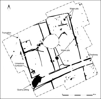
(1) Biddenham, land north of Biddenham (TL 0245 5070): three areas within an excavation covering c. 4 ha contained evidence for Roman activity. Most significant was a farmstead over 1.5 ha in area comprising at least four rectilinear enclosures on either side of a trackway and therefore comparable in layout to farmsteads within the Biddenham Loop, c. 1.5 km to the south.Footnote 193 The trackway was defined by two parallel ditches, c. 9 m apart, and continued beyond the limit of excavation in both directions (fig. 16). Within the enclosures were dispersed and clustered groups of small pits and post-holes, four water pits, hints of limestone and cobbled surfaces and an area of quarry pits, these last located to exploit a band of clay, although no kilns or kiln furniture were present. No obvious buildings were identified but a larger quantity of domestic debris was found in the enclosures to the north of the trackway, indicating where the farmstead's domestic focus lay. The pottery assemblage dates mainly to the second and third centuries a.d.; the absence of late Iron Age material suggests that the farmstead was newly created in the post-Conquest period.Footnote 194
Biddenham, excavation plan. (Albion Archaeology)

(2) Luton, Luton Vale Cemetery extension (TL 1060 2466): excavation revealed evidence of activity spanning the early Iron Age to the post-medieval period. Iron Age settlement was represented by enclosure and boundary ditches, a series of at least three roundhouses and a number of pits and large watering-holes. The Roman period witnessed increased formalisation of enclosures and other boundaries; a number of large pits/post-holes relating to early Roman settlement were also established in the southern part of the site. A small cemetery was identified in the north-east corner of an enclosure in the southern part of the site. This was probably initially established in the Iron Age when a small barrow appears to have been constructed, into which a number of possible graves (no bone survived) were subsequently inserted. This cemetery continued to be used throughout the Roman period, during which time seven cremation burials were added.Footnote 195
(3) Pertenhall, land to the south of Manor Farm (TL 076 644): evaluation revealed numerous ditches and furrows, along with several pits dispersed across five fields. Trenches were positioned to the east of a series of geophysical anomalies interpreted as a probable Roman villa: these remains were to be left in situ. No features relating directly to the villa were identified and most of the few finds recovered were probably residual. This land to the east of the suspected villa is low-lying and wet, overlying the Oxford Clay, and would probably have been damp pasture unsuitable for occupation.Footnote 196
HERTFORDSHIRE
(1) Buntingford, land north of Hare Street Road (TL 3678 2958): excavations targeted ditched enclosures that had been identified by a geophysical survey and subsequent evaluations. The two ditched enclosures were of Iron Age date. Further remains encountered included a series of lazy bed furrows of probable Roman date and numerous quarry pits spanning the Iron Age to the post-medieval periods: these presumably targeted the chalky marl underlying the site. Roman settlement remains, comprising a roundhouse gully and associated pits enclosed by a substantial settlement boundary ditch, were located in the south-western corner of the site.Footnote 197
(2) Dacorum: 4 silver denarii (three Republic and one of Vespasian) to a.d. 78.Footnote 198
(3) Flamstead End: 8 silver denarii and 66 AE sestertii/fractions to c. a.d. 244. 20 later radiates and nummi were also recovered but are very unlikely to be part of the hoard. An aureus of Trajan was previously found nearby.Footnote 199
(4) Hertford, land at Simon Balle School, Mangrove Road (TL 3326 1214): Roman activity was represented by post-holes, cultivation gullies and quarry pits. Evidence of landscaping and levelling was identified across much of the site, presumably associated with the construction of the school in the mid-twentieth century.Footnote 200
(5) Salhouse, Stonehouse Road (TG 2993 1555): evaluation identified possible Iron Age ring gullies, Roman pits, an undated well and undated boundary ditches in trenches within the southernmost field evaluated.Footnote 201
(6) St Albans (Verulamium), King Harry Lane (TL 13 07): a hoard 147 copper-alloy radiates/nummi of c. a.d. 383. The grouping of the coins and the lack of evidence of a container suggests they had been kept in a fabric purse/pouch. A flint nodule placed over the coins may have acted as a marker.Footnote 202
BUCKINGHAMSHIRE
(1) Emberton, Emberton Solar PV Array (SP 9006 4953): evaluation following on from cropmark analysis and a geophysical survey confirmed the presence of a rectilinear enclosure associated with Roman finds. A possible trackway, a ditch and part of a circular enclosure were undated.Footnote 203
(2) Ilmer, land at Bumpers Farm (SP 7642 0614): evaluation recorded enclosure ditches and pits. The pottery and animal bone assemblages indicate a late Roman farmstead located on high ground within the south-eastern part of the site. The lower-lying areas were presumably utilised for agriculture.Footnote 204
OXFORDSHIRE
(1) Chalgrove: 10 base metal radiates to c. a.d. 279.Footnote 205
(2) Dorchester-on-Thames: (a) Discovering Dorchester Project (SU 5774 9410): the training excavation in the allotments overlying the south-west quarter of the Roman town continued.Footnote 206 Early Roman (roughly mid-first century a.d.) features were located in the western part of the site, but not enough of these have yet been seen for their character to be clear, so it is uncertain if any relate to a postulated early Roman fort perhaps underlying the later town. All the early features were sealed beneath a deep (c. 0.25–0.30 m thick) layer of clayey loam which contains animal bone and pottery, the latter apparently all of first-century date. The character of the deposit is uncertain, but it may reflect horticultural activity. This suggests a fairly low level of activity within the settlement in the later first century a.d. The earliest gravel surface of the main north–south Roman road at the east end of the site was laid on top of this deposit; the relatively late date (perhaps not before c. a.d. 100) for the road is surprising, as is the apparent lack of any evidence for street frontage buildings on the west side of the road in what should have been a prime location. The clearest structural evidence (excavated in previous seasons) lies in a ditched enclosure set back some 20 m west of the road. A well within the enclosure was dug just over 2 m down from the contemporary ground surface to the interface of terrace gravel and the underlying Oxford Clay, but produced no waterlogged environmental evidence. The fills included a complete small pottery beaker, perhaps deposited deliberately, and other pottery of mid–late second-century date, but their relatively clean character might suggest that the well was only in use for a short period of time.
In the later Roman period the area between the building enclosure and the road seems to have remained an open space. Examination of a 3 m-wide section through the road sequence confirmed the presence of three principal surfaces, with some evidence for localised patching within that sequence. The latest of the three road surfaces overlay a coin dated a.d. 388–402, so it is associated with the abundant evidence for very late Roman activity examined in previous seasons. An important element of this activity is a pair of west–east ditches aligned perpendicular to the road at the northern margin of the site. The more southerly of these appeared to have cut a whole series of earlier features, perhaps a row of pits.
(3) East Challow, land off Windmill Close (SU 3793 8767): Roman pottery recovered in an evaluation may hint at a Roman origin for remnant field-systems shown on historic maps of 1753 and 1780, given the proximity of a known Roman villa to the north, although the abraded nature of the sherds and small size of the assemblage suggest residuality.Footnote 207
(4) Harwell, land south of Grove Road (SU 4887 8942): evaluation of a 2.6 ha site revealed densely distributed and intercutting features indicative of a multi-phase settlement. Most features were of early to middle Iron Age and Roman date, whilst a few were more likely post-Roman/Anglo-Saxon. An apparent rectilinear field-system was probably established during the Roman period, represented by ditches and pits.Footnote 208
(5) North Leigh: (a) Roman Villa (SP 397 154): a watching-brief during the installation of new visitor information signs at the villa recorded two layers potentially associated with the levelling of the villa courtyard, or buried ploughsoil. These deposits contained ceramic building material and a Roman pottery sherd. The lower deposit overlay a possible stone and mortar structure, although the limited extent of the excavations made the true extent, form and function of this structure impossible to determine. Two deposits of probable spoil from the early twentieth-century excavations of the villa were observed to the north-west of the central range.Footnote 209
(b) 71–81 Park Road (SP 3922 1303): an evaluation adjacent to an area where sizeable quantities of Roman tile were discovered in the 1970s recorded a ditch or pit containing early Roman finds. Roman roof-tile and pottery were present in the topsoil and subsoil across the entire site.Footnote 210
(6) South Leigh, Gill Mill Quarry (SP 384 067): excavation of the final segment of quarry area Tar Farm 8 was completed, bringing 25 years of work in this phase of the quarry to a close. The area immediately adjoined that examined in 2013.Footnote 211 The boundaries of plots lying north of the roadway running ESE down the valley away from the settlement focus to the west were examined. The northern part of the plot containing a previously excavated smithy structure was subdivided into three areas, but these contained little clear sign of activity except for a few pits. A roughly paved area in the south-west corner of the adjacent plot to the east may have carried a structure, but this is not certain. More pits lay immediately east of this area, within the plot. Associated finds were almost entirely of later third- to fourth-century date.Footnote 212
(7) ‘South Oxfordshire’: 22 denarii and 29 radiates to c. a.d. 271 are additional to an earlier find of 16 coins.Footnote 213
(8) Tackley, land at Wootton Balk (SP 4645 2024): an evaluation subsequent to geophysical survey confirmed the presence of a number of rectilinear enclosures and other features in the southern part of the site, representing a settlement of first-century a.d. date. There was no evidence that the settlement began before the Roman conquest or that it continued beyond the end of the first century. Such a tight chronological span is unusual in the region, but third- to fourth-century pottery recorded in an earlier fieldwalking exercise may suggest that the focus of settlement shifted in the later Roman period. In the northern part of the site a possible trackway, almost certainly associated with the settlement area to the south, was recorded both as geophysical anomalies and as archaeological features. A number of other anomalies, apparently representing enclosures, however, were not found within the trenches, but the anomalies were of a discontinuous nature and it is possible that corresponding archaeological features existed beyond the excavated trenches.Footnote 214
(9) Uffington, Station Road (SU 3085 8948): evaluation found evidence for Roman settlement, including enclosures, a possible cobbled path and large amounts of iron-working slag. Large quantities of pottery were recovered covering the middle Iron Age through to the fourth century a.d. An occupation layer evident across much of the site yielded large quantities of Roman finds.Footnote 215