It was not that long ago, at least by radiocarbon date reckoning, that the so-called Vacant Quarter (Williams Reference Williams1983, Reference Williams, Dye and Cox1990) was viewed as somewhat of a demographic singularity (Figure 1): How and why could such a large portion of the mid-continent of North America be abandoned by sedentary, agricultural peoples making up the Mississippian chiefdoms of the fifteenth century AD? By Williams's (Reference Williams, Dye and Cox1990) estimation, most of the traditional Mississippian period core area was “burned out” well before the arrival of Europeans on Native American soil. This kind of exodus is perhaps understandable in places such as the American Southwest, where pronounced oscillations in the scarcity and abundance of water fostered large-scale migrations (e.g., Hill et al. Reference Hill, Clark, Doelle and Lyons2004; Lekson and Cameron Reference Lekson and Cameron1995). While the timing of the Vacant Quarter seems to coincide with a period of pronounced droughts (Meeks and Anderson Reference Meeks, Anderson, Wingard and Eileen Hayes2013), significant portions of the region are dissected by sizable drainages that we know did not dry up even in times of drought, not least of which are the Mississippi and Ohio Rivers.
General boundaries of the Vacant Quarter (based on Williams Reference Williams, Dye and Cox1990).

Suffice it to say, the jury is still out on the causes of the large-magnitude movement of peoples. We think that this poses an even larger question than was once thought because it now appears that there were other contemporary regional abandonments elsewhere in eastern North America (Anderson Reference Anderson1994; Johnson Reference Johnson1996; Williams Reference Williams, Brose, Wesley Cowan and Mainfort2001). Apparently, an extensive atmosphere of destabilization permeated a much larger region than just the Vacant Quarter in the fourteenth and fifteenth centuries.
At this time, it is difficult to delineate the timing and tempo of the unfolding of the Vacant Quarter with precision or certainty. We argue that a better handle on chronology is an important first step toward addressing this phenomenon. A regional abandonment taking place over the course of 25 years potentially has very different causes and consequences than one taking place over a 200-year span. Although there is now a solid corpus of Mississippian radiocarbon dates from throughout the region (Meeks and Anderson Reference Meeks, Anderson, Wingard and Eileen Hayes2013), they have not been collected with the express purpose of addressing issues of abandonment. Instead, they represent a compilation derived from decades of fieldwork across numerous archaeological sites.
By way of contrast, in the United Kingdom robust models for archaeological sites and regions have provided chronologies that have completely transformed understandings of archaeological histories (Bayliss Reference Bayliss2009, Reference Bayliss2015; Hamilton et al. Reference Hamilton, Haselgrove and Gosden2015). Careful implementation of scientific dating and chronological modeling has allowed for the creation of site histories in Britain at generational scales. Corresponding syntheses of detailed regional archaeological narratives have brought new understandings to past phenomena. There has yet to be a project in North America on the same scale as this British chronological work (Hamilton and Krus Reference Hamilton and Krus2018; Thompson and Krus Reference Thompson and Krus2018), in part because this kind of enterprise represents a daunting logistic and fiscal challenge. For example, the chronological modeling projects overseen by Alex Bayliss at Historic England have involved the careful submission and selection of thousands of samples for new radiocarbon dates (for example, see Bayliss et al. Reference Bayliss, van derPlicht, Bronk Ramsey, McCormac, Healy, Whittle, Whittle, Healy and Bayliss2011; Denaire et al. Reference Denaire, Lefranc, Wahl, Ramsey, Dunbar, Goslar, Bayliss, Beavan, Bickle and Whittle2017; Richards et al. Reference Richards, Meirion Jones, MacSween, Sheridan, Dunbar, Reimer, Bayliss, Griffiths and Whittle2016; Tasić et al. Reference Tasić, Marić, Filipović, Penezić, Dunbar, Reimer, Barclay, Bayliss, Gaydarska and Whittle2016; Whittle et al. Reference Whittle, Bayliss, Barclay, Gaydasrka, Bánffy, Borić, Draşovean, Jakucs, Marić, Orton, Pantović, Schier, Tasić and Vander Linden2016).
With this in mind, we turn our attention to the Middle Cumberland region (MCR) of Tennessee to demonstrate that the promise of this kind of effort merits the chronological investments made by our colleagues across the Atlantic. Although our study sample includes radiocarbon dates from various unrelated projects, they can still serve as a robust foundation for exploring the timing of the Vacant Quarter in a similar manner to British archaeological projects driven by chronological modeling. In Williams's (Reference Williams1983, Reference Williams, Dye and Cox1990) original formulation the MCR was considered part of the Vacant Quarter, and a later synthesis by Moore and Smith (Reference Moore and Smith2012) has further demonstrated that the area was depopulated sometime in the AD 1400s. However, did all subregions of the Vacant Quarter experience general population decline and/or emigration at approximately the same time, or was there a time lag that created more of a time-transgressive process?
By introducing Bayesian chronological modeling of the radiocarbon dates available from late Thruston phase settlements, which date to the final phase of Mississippian period activity in the MCR (Beahm Reference Beahm2013:259–261; Moore and Smith Reference Moore and Smith2012), we cast some light on issues surrounding the relative synchronicity of depopulation at multiple scales. The key questions are (1) Is it possible to evaluate whether the timing of population loss varies within the MCR? (2) Does abandonment in this region vary significantly from that in other subregions in the Vacant Quarter? and (3) Is it possible to use a high-resolution chronology in the MCR to better understand the regional history at decadal scales and to use these data to contextualize site-specific, historically contingent reasons for social change?
The Vacant Quarter and Other Regional Abandonments
In his initial formulation of the Vacant Quarter hypothesis, Williams (Reference Williams1983, Reference Williams, Dye and Cox1990) estimated that abandonment occurred within the 100-year interval between AD 1450 and 1550. His study was based on an insightful and panoramic melding of diagnostic horizon markers and radiocarbon dates. Morse and Morse (Reference Morse and Morse1983) suggested that the abandonment was perhaps 50 to 100 years earlier in the Central Mississippi Valley, whereas Cobb and Butler (Reference Cobb and Butler2002) have argued that in the Lower Ohio Valley the last significant vestiges of population disappeared around AD 1450.
As Meeks and Anderson (Reference Meeks, Anderson, Wingard and Eileen Hayes2013) have pointed out, this kind of variation has given the appearance—questionable in their opinion—that the Vacant Quarter abandonment was a clinal phenomenon with some subregions depopulated well before others. After compiling a sample of 557 radiocarbon dates from five subregions throughout the Vacant Quarter, including the Middle Cumberland drainage, they argued that widespread, synchronic abandonment seems to have occurred by about AD 1420. They reached their conclusion by observing that the summed calibrated probability distributions of the radiocarbon dates for each of the subregions displayed a similar notable decline at the beginning of the fifteenth century—a point that we will revisit.
Widespread as it was, it now appears that the Vacant Quarter may not have been an isolated occurrence in the late prehistoric Southeast. Anderson (Reference Anderson1994) describes depopulation of a large portion of the Savannah River drainage in the 1400s; Johnson (Reference Johnson1996) posits that abandonment of the Upper Tombigbee Drainage may be related to the Vacant Quarter phenomenon; and Williams (Reference Williams, Brose, Wesley Cowan and Mainfort2001) argues that the Yazoo Basin in the Lower Mississippi Valley also witnessed a massive population decline in the fifteenth century. It should be noted that no one working on the Vacant Quarter or related abandonments has suggested that a complete evacuation of people occurred. It is possible that hamlets and encampments persisted up until the arrival of Europeans.
Meeks and Anderson (Reference Meeks, Anderson, Wingard and Eileen Hayes2013) have documented that the Vacant Quarter phenomenon generally correlates with a series of severe droughts beginning in the late AD 1200s, as inferred through tree ring proxies for precipitation. This presumes quite reasonably that there would be a time lag between the onset of the first droughts and the eventual departure of populations under duress. Their study is based partially on a recent climatological reconstruction demonstrating significant and large-scale droughts over a considerable portion of the Midwest and Southeast during the fifteenth and sixteenth centuries (Cook et al. Reference Cook, Seager, Cane and Stahle2007). Based on the same climatological data, Benson and colleagues (Reference Benson, Pauketat and Cook2009) suggest that an earlier series of droughts spanning AD 1100–1245 may also have played a role in the decline of Cahokia. Likewise, North Atlantic climatic fluctuations during the Mississippian period may have helped precipitate cultural and sociopolitical changes; for example, cooler temperatures during the onset of the Little Ice Age (about AD 1400) may have negatively impacted maize agricultural yields and increased the scarcity of food (Benson et al. Reference Benson, Berry, Jolie, Spangler, Stahle and Hattori2007; Benson et al. Reference Benson, Pauketat and Cook2009; Bird et al. Reference Bird, Wilson, Gilhooly, Steinman and Stamps2017; Cook et al. Reference Cook, Smerdon, Seager and Cook2014; Milner Reference Milner1999; Milner et al. Reference Milner, Chaplin and Zavodny2013).
Even if one does not subscribe to environmental or climatological determinism, it is difficult to accept that so many coeval regional depopulations were instigated throughout the Southeast solely by social factors. Nevertheless, it is important to consider climate within the context of cultural and social agency, particularly with regard to the various ways in which communities may respond to stress. For example, Meeks and Anderson (Reference Meeks, Anderson, Wingard and Eileen Hayes2013) posit that, over the course of time, significant declines in maize yields among Mississippian polities had political as well as demographic consequences—as the surpluses that underlay chiefdom political economies evaporated, so did the power of those chiefs. The resulting broad-scale social reorganization was accompanied by conflict and unrest that eventually led to significant population movements. Buchanan (Reference Buchanan, Buchanan and Skousen2015) also sees warfare as playing a role in the large-scale exodus manifested by the Vacant Quarter, advancing a model whereby regional conflict was tightly integrated with a cultural landscape of spirits and otherworldly practices.
Although it is now widely accepted that the Mississippian Southeast was always in a state of flux, the late Mississippian period seems to have witnessed population movements on an unprecedented scale. Climate change clearly seems to have been one factor, if not the only one. We suggest that building detailed chronological models of subregions is a necessary step toward addressing the complex processes underlying large-scale population movements, as well as the consequences of those migrations.
The Middle Cumberland Region
A primary reason that we focus on the Middle Cumberland is that our recent assessment of the occupation span of one site in that region, Averbuch, did not quite square with Meeks and Anderson's (Reference Meeks, Anderson, Wingard and Eileen Hayes2013) chronology of abandonment. Whereas they have hypothesized that it occurred in the MCR around AD 1420, our Bayesian models of radiocarbon dates from Averbuch provided a site closure estimate of about 25 to 50 years later (Cobb et al. Reference Cobb, Krus and Steadman2015). Aside from statistical variation and overlap, numerous causes could account for this discrepancy. It is conceivable that the residents of Averbuch managed to persist for a few more decades after everyone else had departed. However, it is also possible that abandonments of the MCR deviated from the current expectations for the Vacant Quarter on a larger scale. This is an issue that can be addressed with more site-specific Bayesian chronological models for other MCR settlements.
To their credit, Meeks and Anderson (Reference Meeks, Anderson, Wingard and Eileen Hayes2013) relied on a very large sample of 557 dates across 113 sites, which included 111 dates from 29 MCR sites. They developed summed probability distributions (using CALIB 5.0.1) for each of five subregions in the Vacant Quarter to arrive at their early fifteenth-century estimate of abandonment. Their data revealed a trickle of radiocarbon dates in each region that postdates the mid-AD 1400s. At the same time, the summed probabilities displayed what they viewed as a “precipitous decline” (Meeks and Anderson Reference Meeks, Anderson, Wingard and Eileen Hayes2013:75) in the AD 1380–1420 interval, providing a basis for their AD 1420 widespread abandonment hypothesis.
Although we believe that Meeks and Anderson correctly identified a larger abandonment event or process, interpreting patterns of calibrated radiocarbon probabilities based on visual evidence alone is an imprecise practice that can be refined with Bayesian modeling. For example, the 18 radiocarbon dates from the Averbuch site provide a summed probability distribution that shows a steep decline in the fifteenth century (Cobb et al. Reference Cobb, Krus and Steadman2015). Bayesian modeling allowed us to go one step further to probabilistically estimate the terminus of the site occupation at cal AD 1430–1500 (95% probability) or cal AD 1440–1475 (68% probability; Cobb et al. Reference Cobb, Krus and Steadman2015:Figure 3).
To be fair, Meeks and Anderson's reliance on the probability distribution of radiocarbon dates is a common practice for approximating the establishment, occupation, and abandonment of sites and regions; in fact, Cobb and Butler (Reference Cobb and Butler2002) used the same method for estimating the Ohio River valley depopulation within the larger Vacant Quarter. However, the use of summed probabilities to interpret regional archaeological phenomena can be greatly skewed by calibration curve wiggles, nonproportional sampling, residual samples from postdepositional taphonomic processes, and uncorrected radiocarbon offsets such as from the old wood effect or from uncorrected fractionation (Contreras and Meadows Reference Contreras and Meadows2014; Williams Reference Williams2012). One of the advantages of Bayesian chronological models for human activity is that they can accommodate these biases within the chronological estimates of events (Bayliss Reference Bayliss2009, Reference Bayliss2015).
This is not to say that Bayesian approaches render summed probability distributions obsolete. A number of studies show that summed probability distributions provide a useful initial perspective on trends within the overall occupation of a site or region. Deviations or patterns of interest in these trends can subsequently be bracketed and explored with a high degree of resolution through Bayesian modeling (e.g., Marsh Reference Marsh2015).
Given this background, we expanded our sample of sites in the MCR to evaluate whether Averbuch was either a late outlier in the Vacant Quarter or an example of a larger pattern of abandonment in the drainage that could be assigned to the mid- to late AD 1400s. Rather than including all MCR radiocarbon dates in our analysis, we focused on sites with late Thruston phase (AD 1350–1450) components, the final phase of Mississippian activity in the MCR (Beahm Reference Beahm2013:259–261; Moore and Smith Reference Moore and Smith2012). There are six Mississippian sites in the MCR that have yielded both late Thruston phase ceramic traits and sufficient numbers of radiocarbon samples with which to build an initial model of regional abandonment (Figure 2): Averbuch (40DV60), a palisaded village on a small drainage north of the Cumberland River (Cobb et al. Reference Cobb, Krus and Steadman2015; Klippel and Bass Reference Klippel and Bass1984); Brentwood Library (40WM210), a palisaded village on the Little Harpeth River (Moore Reference Moore2005); East Nashville Mounds (40DV4), a large multimound site on the Cumberland River (Walling et al. Reference Walling, Alexander and Peacock2000); Gordontown (40DV6), a palisaded multimound town located on a tributary of Mill Creek (Moore and Breitburg Reference Moore and Breitburg1998; Moore et al. Reference Moore, Breitburg, Smith and Beth Trubitt2006); Rutherford-Kizer (40SU15), a large and fortified multimound site on a tributary creek south of the Cumberland River (Moore and Smith Reference Moore and Smith2001); and Sellars (40WI1), another site on a tributary creek south of the Cumberland River (Butler Reference Butler1981).
Late Thruston phase sites used for modeling abandonment in the Middle Cumberland region.

Importantly, there are radiocarbon measurements from archaeological samples from each of these sites (Supplemental Table 1). This essay applies a Bayesian methodology (Bronk Ramsey Reference Bronk Ramsey2009a) to date the timing of activity at each of the individual late Thruston phase sites. Using a Bayesian framework, we estimate the chronology of this activity with radiocarbon dates and the relative dating information provided by stratigraphy and feature groupings.
Methodology
Our dataset includes all available radiocarbon dates (n = 65) from late Thruston phase (AD 1350–1450) sites in the MCR,13 from new measurements and 52 from the published literature. The new samples were obtained from curated archival materials held by the Tennessee Division of Archaeology. Samples were selected for new dating only if their context was securely associated with curatorial and excavation records. Of the 65 radiocarbon measurements, 58 were made on wood charcoal, four on nutshell, two on maize, and one on a sample of residue or soot.
The radiocarbon measurements, presented in Supplemental Table 1, are quoted in accordance with the Trondheim Convention (Stuiver and Kra Reference Stuiver and Kra1986) as conventional radiocarbon ages (Stuiver and Polach Reference Stuiver and Polach1977); this table also includes contextual and descriptive details for the samples. Calibrated date ranges were calculated using IntCal13 (Reimer et al. Reference Reimer, Bard, Bayliss, Warren Beck, Blackwell, Bronk Ramsey, Buck, Cheng, Lawrence Edwards, Friedrich, Grootes, Guilderson, Haflidason, Hajdas, Hatté, Heaton, Hoffmann, Hogg, Hughen, Kaiser, Kromer, Manning, Niu, Reimer, Richards, Marian Scott, Southon, Staff, Turney and van der Plicht2013) and OxCal v4.3. They are cited in the text as 95% confidence intervals, with the end points rounded outward to 10 years. The technique used for Bayesian chronological modeling is a form of Markov chain Monte Carlo sampling (Bronk Ramsey Reference Bronk Ramsey2009a) and has been applied using the program OxCal v4.3. The fit between the OxCal model and data is gauged with the Amodel agreement index, and values higher than 60 indicate good agreement between the model parameters and the dates (Bronk Ramsey Reference Bronk Ramsey2009a). Resulting posterior density estimates from OxCal are calendar years and presented as probability ranges with end points rounded to the nearest five years. The algorithms used in the models can be derived from the model descriptions and OxCal code. Note that the posterior density estimates produced by modeling are not absolute. They are interpretative estimates, which can and will change as new data become available and as other researchers choose to model the existing data from different perspectives.
Results
Chronological models were constructed and run in OxCal, one for each late Thruston phase site. The structure of each model is presented in the model descriptions (Supplemental Text 1) and the model code (Supplemental Text 4). The taphonomic relationships each radiocarbon sample possesses with its corresponding archaeological context are described in Supplemental Table 1 and Supplemental Text 1.
The Bayesian chronological models use charcoal outlier modeling as a strategy for accounting for the unknown inherent age offset in wood charcoal and soot samples (Bronk Ramsey Reference Bronk Ramsey2009b). These models assume an exponential distribution, with an exponential constant τ of 1 taken over the range −10 to 0, of the charcoal dates (following Bronk Ramsey Reference Bronk Ramsey2009b). The shifts are then scaled by a common scaling factor that can lie anywhere between 100 and 103 years.
The models show good overall agreement between the radiocarbon dates and the assumptions of the models (Supplemental Text 1). Detailed results for these models are summarized in Tables 1–2 and Figures 3–7. A model for Gordontown is not provided, because only two radiocarbon dates are available from this site, which is not a robust enough sample to construct a meaningful chronological model for the site occupation. As a result, Supplemental Text 1 presents a review of the radiocarbon data from Gordontown and describes what can be inferred about the site chronology from the two existing dates.
Comparison of Bayesian Modeling Probability Ranges with Previous Estimates for Late Thrustan Phase Site Chronologies in the Middle Cumberland Region.

Note: All dates are in cal AD.
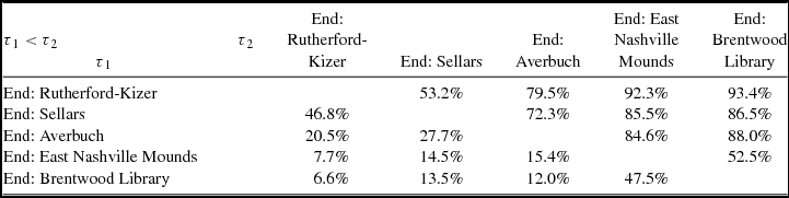
Probability Matrix that Event τ1 Occurred before Event τ2 in the Primary Models.

Note: τ represents an exponential constant.
Posterior probability densities for the start of activity at late Thruston phase sites in the Middle Cumberland region.

Posterior probability densities for the end of activity at late Thruston phase sites in the Middle Cumberland region.

Posterior probability density for the estimated span of time between the end of activity at Brentwood Library and the end of activity at Rutherford-Kizer in the primary models.

Posterior probability densities for the timing of palisade construction at late Thruston phase sites in the Middle Cumberland region.

Posterior probability densities for the estimated spans of settlements and palisades at late Thruston phase sites in the Middle Cumberland region.

Alternative versions of each model were created as a sensitivity analysis by slightly modifying the primary models. Specifically, charcoal outlier modeling was not used in the alternative versions of each model. The alternative models show good overall agreement between the radiocarbon dates and the assumptions of the models (Supplemental Text 2). Overall, the posterior probabilities for the alternative models are mostly identical to those of the primary models, although a few are slightly older than the primary model counterparts, which was expected because the alternative models do not use charcoal outlier modeling and are thus much more sensitive to radiocarbon measurements from old wood. The results from the primary models are preferred because they account for the unknown inherent age offset in wood charcoal and a potential soot sample with charcoal outlier modeling (Bronk Ramsey Reference Bronk Ramsey2009b).
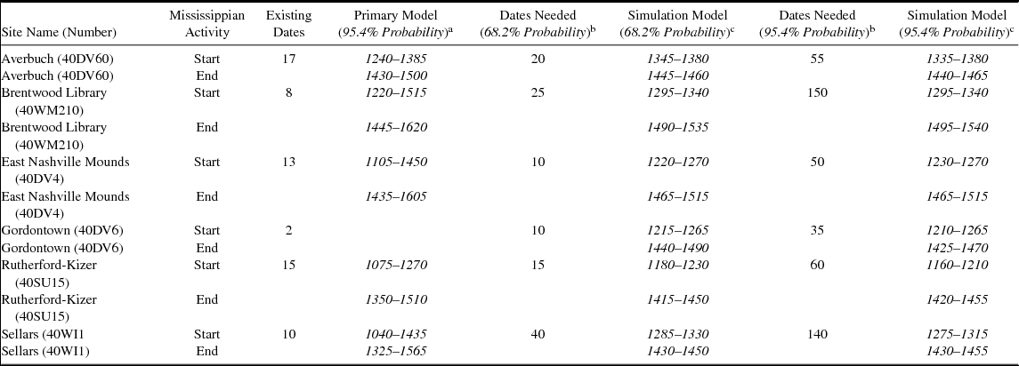
We also took the additional step of running a simulation experiment in OxCal to determine the minimum number of additional radiocarbon dates that might be needed to achieve Bayesian chronological modeling results of much higher precision in the primary models for the start and end of activity at each site. This simulation experiment is described fully in Supplemental Texts 3 and 4, and the results are summarized in Table 3 and Figure 7. We believe that this approach is an important means of estimating the number of radiocarbon samples required to address specific chronological questions posed by research designs.
Summary of the Minimum Number of Simulated Radiocarbon Dates Required to Meet the Simulation Experiment Parameters.

Note: Posterior 68% and 95% probability confidence intervals span 50 years (or less) for both the start and end of activity in the simulation models. All dates are in cal AD.
a Using no simulated dates.
b Number of additional dates needed to provide 50-year resolutions at given percent probability.
c Simulation with 50-year resolutions at given percent probability.
Discussion
Bayesian modeling provides posterior probabilities for the start and end of activity at each late Thruston phase site (Figures 3 and 4; Table 1). When compared with the previous calendar year estimates for the chronology of these sites, the chronologies created with Bayesian modeling are more variable, demonstrating the unique history of each settlement (Table 1). Further, the chronologies created with Bayesian modeling are more useful than the previous chronological estimates (Table 1) because they provide an explicit chronological framework for the timing of human activity that is independent from relative artifact chronologies.
Supplemental Text 1 describes the full details of the posterior probabilities; they estimate that activity at each settlement began around AD 1200 to 1400. The final activity at each settlement is estimated to have occurred around the originally defined time frame for the Vacant Quarter of AD 1450–1550 (Williams Reference Williams1983, Reference Williams, Dye and Cox1990). Importantly, activity at all of the sites likely lasted later than Meeks and Anderson's (Reference Meeks, Anderson, Wingard and Eileen Hayes2013) hypothesized Vacant Quarter abandonment of AD 1420. Further, at 68% probability, activity at East Nashville Mounds and Brentwood Library is estimated to have potentially lasted until AD 1525 (Figure 4; Table 1).
A matrix comparing the posterior probabilities for the end of activity at late Thruston phase sites in the MCR was created to best determine the order of site abandonment (Table 2). At 68% probability, the earliest terminus at a site for human activity is at Rutherford-Kizer at cal AD 1400–1465, and the latest is at Brentwood Library at cal AD 1460–1525 (Tables 1 and 2). The estimated span of time between these two posterior probabilities is 15–115 years at 68% probability (Figure 5), which provides an estimate for the rate of Mississippian abandonment in the MCR and demonstrates that regional abandonment likely unfolded over less than a century.
The estimate for the end of activity at Brentwood Library (cal AD 1460–1525, 68% probability; Table 1) provides the best current estimate for the final abandonment of the MCR. If the Meeks and Anderson (Reference Meeks, Anderson, Wingard and Eileen Hayes2013) model for other portions of the Vacant Quarter is accurate, then the MCR was depopulated about 50 to 100 years later than the other subregions. Nevertheless, if we treated the reservoir of dates examined by Meeks and Anderson (Reference Meeks, Anderson, Wingard and Eileen Hayes2013) to similar Bayesian analyses, then it is possible that a different perspective would emerge. It is conceivable, for example, that the Vacant Quarter represented a geographic time-transgressive phenomenon, with the MCR being vacated later than other subregions. Alternatively, each subregion in the Vacant Quarter may have experienced a distinct abandonment history. This possibility is reflected in the MCR, where it appears that the abandonment of the last communities may have been a staggered process, itself a complex product of local social, ecological, and environmental variables. Our ability to hone in on these kinds of patterns with more precision is an important step toward addressing both the causes and consequences of the larger Vacant Quarter abandonment as well as subregional variations in depopulation.
Even if late fifteenth-century Thruston phase instability was precipitated by droughts, other factors beyond climate clearly were at work. This is indicated by the estimates from the Bayesian chronological models for palisade construction and maintenance at the late Thruston phase sites in the MCR, all of which seem to have been surrounded with fortifications (Figures 6 and 7; Table 1). These models provide the first definitive and precise estimates for Mississippian palisade construction and maintenance in the MCR and indicate that this activity continued at each late Thruston phase site into the fifteenth century. At 68% probability, the final palisade maintenance activity took place at Brentwood Library at cal AD 1450–1500 (Figure 6). Bastions are present on the fortifications at each late Thruston phase site in the MCR, except for Averbuch, suggesting that considerable effort went into building the palisades at these sites so that they could inflict flanking fire on attackers (Keeley et al. Reference Keeley, Fontana and Quick2007:67; Milner Reference Milner1999, Reference Milner and Tracy2000, Reference Milner, Chacon and Mendoza2007; Milner et al. Reference Milner, Chaplin and Zavodny2013). Attack from contemporaneous populations seems to have been a pervasive threat in the MCR in the fifteenth century.
The chronological models indicate that the late Thruston phase palisades were potentially maintained for multiple generations, possibly well over a century. Specifically, at 68% probability the palisade at Sellars is estimated to have been maintained for 1–160 years, the palisade at Rutherford-Kizer for 110–210 years, the palisade at Brentwood Library for 40–145 years, and the palisade at Averbuch for 40–105 years (Figure 7). Long-term Mississippian palisade use involved repairs and expansions, sometimes of massive character (Krus Reference Krus2016), indicating that coordinated Mississippian workforces were present at late Thruston phase settlements in the fifteenth century to maintain these sizable structures.
Our next step is to design a project that aims to create high-resolution site-based chronologies for all known Mississippian settlements in the MCR, in part to better understand the exact timing and tempo of the multiscalar social changes that made up the Vacant Quarter. Additionally, it may be possible to further refine the posterior probabilities estimated in this study to provide regional histories of a much higher precision, which was the goal of the simulation experiment (Supplemental Text 3). Table 3 and Figure 8 show the minimum number of simulated radiocarbon dates required to meet the simulation model parameters with posterior 68% and 95% probability confidence intervals spanning 50 years (or less) for the start and end of activity at each late Thruston phase settlement. These simulations demonstrate that a minimum of 10–40 simulated radiocarbon dates are needed to achieve 68% probability confidence intervals spanning 50 years for the start and end of activity at a given late Thruston phase settlement and that a minimum of 35–150 simulated radiocarbon dates are needed to achieve 95% probability confidence intervals spanning 50 years.
Solid posterior probabilities are derived from simulation models with the minimum number of simulated radiocarbon dates required to meet the simulation model parameters with posterior 95% probability confidence intervals spanning 50 years (or less) for the start and end of activity. The posterior probabilities shown in outline are derived from the primary Bayesian models and estimate the start and end of activity at the late Thruston phase sites in the Middle Cumberland region.

The simulation experiment demonstrates that dramatically more samples are needed to achieve 50-year confidence intervals for boundaries when the “true” start date defined by the experiment was within the AD 1300s, because of a calibration curve wiggle covering cal AD 1290–1410 (see Krus et al. Reference Krus, Cook and Hamilton2015). Regardless, achieving 50-year confidence intervals for starting and ending boundaries for each site at 68% probability is possible with a more robust dating program for each site (Table 3; Figure 8). We advocate a stepped approach to future radiocarbon submissions, where 5–15 new dates from secure contexts are submitted for each site and the simulation experiments are rerun with the new results to determine how many additional dates are needed to achieve noticeably more precise probabilities for each site (following Bayliss and Bronk Ramsey Reference Bayliss, Bronk Ramsey, Buck and Millard2004 and Hamilton and Krus Reference Hamilton and Krus2018).
Conclusion
In its initial inception, the geographic and temporal parameters of the Vacant Quarter were defined from a medley of radiocarbon dates with wide standard deviations (by modern standards) and from coarse phases tied to diagnostic artifacts. Further refinements to estimates of the regional abandonment have been based largely on summed probability distributions that in turn have benefited from the chronological refinements of accelerator mass spectrometry dating. However, even these assessments still have a sizable subjective component in their interpretation. Further, there is still a tendency for regional chronological analyses to rely on traditional periodizations that may bias data sample selection and reify existing interpretations. While Bayesian analyses support findings from elsewhere in the mid-continent that the Vacant Quarter was largely a fifteenth-century AD phenomenon, they also emphasize that what may appear as a synchronous event at one scale may in fact have been composed of numerous asynchronous mini-abandonments at the community level. The challenge remains as to how to explain the linkages of the different scales of abandonment. Our radiocarbon simulations indicate that future robust dating with well-selected samples from the late Thruston MCR settlements could greatly improve the precision of the existing models.
If the Vacant Quarter depopulation occurred within the space of a century, in some respects this may be considered a temporal event that linked many Mississippian subregions. Our Bayesian modeling of site chronologies suggests that this event may still have had a time-transgressive character, even if fairly rapid, since the MCR abandonment estimates follow those of other regions by several decades. However, until Bayesian chronological models are applied to other subregions in the Vacant Quarter, direct comparisons are somewhat problematic. Nevertheless, we believe that our results do provide some important lessons for researchers elsewhere who are attempting to construct detailed archaeological chronologies. Once the general boundaries of an archaeological target have been delineated, it is possible with Bayesian modeling to make an assessment of the number of dates required to estimate temporal parameters with a given level of desired statistical confidence. In turn, these kinds of assessments should provide a much higher degree of resolution as to whether we are dealing with events, short-term processes, or generational kinds of changes—in other words, the type of information about the tempo of change necessary for developing models of explanation and causality.
Left unstated is the question, Where did all the people go? All of the researchers pursuing this line of inquiry agree with Williams (Reference Williams1983, Reference Williams, Dye and Cox1990) that these phenomena do not represent endemic demographic collapses; instead, communities on a very large scale seem to have decamped for other pastures. Although we do not follow up on this specific issue here, there are intriguing data suggesting sudden population arrivals as well as disappearances in the Southeast. Regnier (Reference Regnier2014) recently demonstrated that a large portion of the Alabama River drainage witnessed a major influx of peoples around AD 1450 after a long interval of near vacancy. Although it is not clear where the immigrants came from, the timing of their arrival with regional abandonments in surrounding areas is certainly suggestive. In eastern Tennessee, others have argued that the late Mississippian Dallas and/or Mouse Creek phases may have incorporated pulses of population from the Middle Cumberland region, although the skeletal data (Berryman Reference Berryman, Willey and Smith1980; Kelso Reference Kelso2013) used to support these arguments still seem equivocal. These kinds of findings emphasize that parallel research on population arrivals as well as population departures is clearly necessary to provide a balanced perspective on regional abandonments.
Acknowledgments
Our deep thanks go to Mike Moore (Tennessee Division of Archaeology) and Kevin Smith (Middle Tennessee State University) for their ongoing assistance in selecting samples and interpreting the results from sites in the Middle Cumberland drainage. We would also like to thank three anonymous reviewers who provided helpful and thoughtful comments. Portions of this research have been funded by the National Science Foundation (BCS-0852686) and the Wenner-Gren Foundation (Grant No. 8477).
Data Availability Statement
This article is based on data from published sources and materials housed at the Archaeological Research Laboratory, University of Tennessee, Knoxville, and the Tennessee Division of Archaeology, Nashville.
Supplemental Materials
For supplementary material accompanying this article, visit https://doi.org/10.1017/aaq.2018.1.
Supplemental Text 1. Description of Bayesian Models and Results.
Supplemental Text 2. Description of Alternative Bayesian Models and Results.
Supplemental Text 3. Description of Simulation Experiments and Results.
Supplemental Text 4. Code for OxCal Models.
Supplemental Table 1. Radiocarbon Data.