

Introduction
On the Saurashtra coast of western India, lithified bioclastic carbonate deposits preserve a record of environmental changes during the Middle to Late Pleistocene. The carbonate deposits are similar to aeolianites elsewhere (Gallup et al., Reference Gallup, Edwards and Johnson1994; Brooke, Reference Brooke2001; Frechen et al., Reference Frechen, Dermann, Nober, Tsatskin, Boenigk and Ronen2002; Erginal et al., Reference Erginal, Kiyak, Ekivci, Demirci, Ertek and Canel2013). Commonly referred to as miliolitic limestones, miliolites, or Porbandarstones, these deposits are pinkish to white, medium- to fine-grained, well-sorted allochthonous limestones that, following Dunham (Reference Dunham1962), can be designated as grainstone or pelsparite, and biopelsparite following Folk (Reference Folk1962).
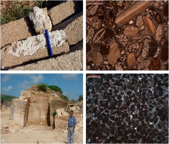
Textural variants of miliolites were described as calcirudite by Mathur et al. (Reference Mathur, Verma and Mehra1988) and as shell limestone by Bhatt and Patel (Reference Bhatt and Patel1998a). These have been considered as indicators of past shorelines. Figure 1 provides the field characteristics and micromorphological details of the two variants. Although shell limestones occur as sheets of beach rock and constitute beach ridges, miliolites (sensu stricto) occur as coastal aeolianites, inland aeolianites (obstacle dunes), valley fills, and fluvially reworked sheet deposits. These terms are used henceforth.
(color online) Photographs showing megascopic characteristics of the shell limestone containing a large fragment of coral from Kuchdi quarry (marker pen is 10 cm long) (a), micromorphology of shell limestone showing bioclasts cemented by meniscus and rim of fibrous aragonite and void filling sparite (bar represents 1 mm) (b), planar cross-stratified aeolianites composed of miliolite at Adityana quarry (height of the person is 160 cm) (c), and its micromorphology exhibiting the very fine-grained, well-sorted nature of peloids cemented with fine crystalline sparite (bar represents 0.5 mm) (d).

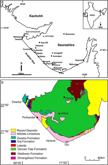
Under a microscope, shell limestones show fibrous and/or micritic aragonite cement, with sparite cement filling the voids. This suggests intertidal conditions during diagenesis. In comparison, miliolites exhibit a variety of cement morphologies—namely, meniscus, dripstone-drapestone, dog-toothspar, nail-headspar, rim, syntaxial overgrowths, and blocky void fillings characterized by nonferroan, low-magnesian sparry calcite mineralogy, which suggests diagenesis under meteoric/freshwater conditions (Bhatt and Patel, 1996; Reference Bhatt and Patel1998b). Figure 2a provides a map of the shell limestone and miliolite occurrences in the region.
(color online) Maps showing locations of sampling sites and other places referred to in the text (a) and geologic setup of Saurashtra (b).

Carter (Reference Carter1849, 158) was the first to describe miliolites in interior Saurashtra as “granular deposits comprising oolitic particles with a predominance of forams belonging to Genus Miliolina.” Although used extensively in the literature, the term miliolite has been a misnomer because of the presence of a larger fraction of allochems other than Miliolidae (Biswas, Reference Biswas1971; Brückner et al., Reference Brückner, Mangini, Montagioni and Rescher1987). Because of their inland occurrence and the petrography of samples (from Junagarh, Porbandar, and Jamnagar that typically contain foraminifera, pellets, ooids, and molluscan shell fragments), debates about their origin as either marine or aeolian began (Chapman, Reference Chapman1900; Evans, Reference Evans1900; Pilgrim, Reference Pilgrim1908; Lele, Reference Lele1973). A littoral origin for miliolite deposits along the coastal fringes and an aeolian origin for the inland miliolite at Dungarpur (Junagarh) and Chotila was suggested (Biswas, Reference Biswas1971; Sperling and Goudie, Reference Sperling and Goudie1975; Agrawal and Roy, Reference Agrawal and Roy1977; Verma and Mathur, Reference Verma and Mathur1976). In contrast, Marathe et al. (Reference Marathe, Rajaguru and Lele1977) and Rajaguru and Marathe (Reference Rajaguru and Marathe1977) suggested that miliolites up to 40 m above mean sea level (amsl) were of marine origin, and those above this elevation were of aeolian origin. Based on 230Th/234U ages of miliolite in the Hiran valley, Baskaran et al. (Reference Baskaran, Marathe, Rajaguru and Somayajulu1986) assigned an age of >56 ka to the deposit and the stone tools that it contains. Archaeologically, these were Lower and Middle Palaeolithic tools. Further, Baskaran et al. (Reference Baskaran, Rajagopalan and Somayajulu1989) relied on the composition of deposits to suggest a marine origin for the inland miliolites and attributed their present elevations to postdepositional uplift of the peninsula by 200 m, with an average uplift rate of 0.23 to 2.2 mm/yr.
Bhatt (Reference Bhatt2003) reviewed the style of deposition, petrography, mineralogy, chronology, geoarchaeology, and origin of these deposits and suggested two textural varieties—namely, (1) biogenic carbonate deposits with a distinct relation to intertidal to supratidal regimes along with backshore dunes linked to coastal environments and (2) inland obstacle dunes linked to aeolian environments. He suggested that this scheme needs reevaluation using sedimentology and geochronology to better understand the land–sea interactions in Saurashtra.
Radiocarbon, 230Th/234U, 234U/238U, and electron spin resonance (ESR) have been used to establish the chronometry of these deposits. A basic difficulty with radiometric ages has been the diagenetic changes and later reworking of carbonates and their transport as grains by aeolian and fluvial agencies followed by cementation. This implies that a priori any age on bulk miliolite (Miliolidae grains + cement) will be younger than the age of individual grains of Miliolidae (cement being younger). In contrast, radiometric dating of the carbonate grains in deposits of aeolian and fluvial origin would provide overestimates, as the ages would correspond to the event of their formation and not the event of their aeolian or fluvial transport with eventual burial.
Measurements of 230Th/234U ages of miliolite samples from Porbandar, both of bulk samples and the cement between grains by Brückner et al. (Reference Brückner, Mangini, Montagioni and Rescher1987), gave a difference of about 30 ka. In one case, the radiometric age of bulk miliolite was 61.0 ka (range, 68.6–54.1 ka; sample no. Por 1c-M), whereas the age of microfauna after removal of the cement was 95.0 ka (range, 123.2–72.6 ka; sample no. Por 1c-M/1:1). Radiocarbon ages suffer complications because of interaction with modern waters percolating through the sample matrix leaving modern carbon that becomes incorporated in the matrix during diagenesis. These alterations lead to unreliable ages (Gupta, Reference Gupta1991).
Lewis et al. (Reference Lewis, Sloss, Murray-Wallace, Woodroffe and Smithers2013) used studies of beach rocks from Australia to suggest that ages of the bioclasts will be the maximum, and for the cement, the ages will be the minimum. In general, radiometric ages on bulk carbonates are inaccurate because of a complex sequence of events of deposition, cementation, and diagenesis. Such ages are geologically untenable as shown by the suggestion of uplift of the entire region by >200 m during the past 200 ka, at rates of 0.23–2.2 mm/yr (Baskaran et al., Reference Baskaran, Rajagopalan and Somayajulu1989), a result totally at odds with geomorphic evidence.
Early attempts, for thermoluminescence (TL) dating of aeolianites from the coasts of Morocco and Spain by Singhvi, published by Brückner (Reference Brückner1986), were not replicated in Saurashtra. The present study used optical dating of miliolite and shell limestones using detrital quartz grains only. This chronometric application assumed the following:
-
1. Quartz grains and allochems were synsedimentary.
-
2. The optically stimulated luminescence (OSL) of quartz grains was bleached to near zero during reworking in the intertidal region as indicated by Rink (Reference Rink1999) and Murari et al. (Reference Murari, Achyuthan and Singhvi2007).
-
3. The OSL of quartz grains was rebleached to near zero during reworking and aeolian transport to form carbonate dunes (Singhvi and Kar, Reference Singhvi and Kar2004).
-
4. On burial, OSL reaccumulation began because of irradiation from ambient radioactivity, which continued unabated until excavation.
-
5. Disequilibrium in the decay chain did not affect the dose rate and hence the age.
-
6. Effects of postdepositional cementation on dose rate are diluted because of the beta particle range of a few millimetres, and beyond this range, any changes in the radioactive environment did not affect the dose rate.
A distinctive advantage of OSL is that it dates the most recent event of miliolite deposition. Thus, for miliolite grains transported subaerially, OSL provides the age of their aeolian deposition and preservation. For those deposited by coastal and fluvial agencies, OSL provides the age of deposition at coastal sites and/or by fluvial sedimentation. Thus, OSL ages provide the age of the most recent deposition, and this holds for all depositional environments.
The present study aimed to elucidate the following:
-
1. Temporal relation between coastal, aeolian, and fluvial sediments and their relationship with eustatic changes.
-
2. Relation between generation of carbonate sediment and its later reworking and deposition under subaerial conditions.
-
3. Comparison of OSL chronology with radiometric dating of reworked miliolites.
Study area
The study area lies between 20°40′N and 22°57′N and 68°57′E and 72°18′E. The climate is arid to semiarid, and seasonal rivers drain it in a radial pattern because of an inverted bowl-like topography. The Saurashtra peninsula is bounded by the Gulf of Kachchh (north), the Arabian Sea (west), and the Gulf of Khambhat (east) (Fig. 2a).
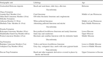
Geologically, the Saurashtra region comprises igneous rocks of the Late Cretaceous Deccan Trap Formation. Jurassic-Cretaceous sedimentary formations (the Dhrangadhra and Wadhwan Formations) occur in the northeastern part. Sedimentary sequences of Miocene to Pliocene age (the Gaj and Dwarka Formations) occupy the northwestern and southeastern coasts, and these also occur as inliers along the southwestern coast. Quaternary deposits rest unconformably either on Miocene sediments or on Late Cretaceous igneous rocks. Merh (Reference Merh1995) suggested that the bioclastic carbonate deposits are of Middle to Late Pleistocene age, and younger unconsolidated coastal dunes and tidal flats are of Middle to Late Holocene age. Table 1 summarizes the stratigraphic framework, and Figure 2b provides the geologic setup of Saurashtra.
Regional stratigraphic framework of Saurashtra (after Bhatt, Reference Bhatt2000).

Field details
The present study included all possible geomorphic and stratigraphic varieties of exposed carbonate sequences—namely, (a) beach rock, (b) beach ridges, (c) coastal aeolianites, (d) stabilized coastal dunes, (d) valley fills and fluvially reworked miliolites, and (e) inland obstacle dunes. Beach rock, beach ridges, coastal miliolites, and stabilized dunes are confined to a kilometre-wide coastal strip. Obstacle dunes, valley fills, and sheets exposed on riverbanks occur over a wider area up to 200 km inland.
Samples from the coastal tract were collected to infer the relative sea levels. Samples from inland obstacle dunes were collected to infer the timing of dune-building episodes. Samples from fluvially reworked miliolite sheets indicated about the timing of fluvial reworking during more humid events.
The sites are described according to the following geographic sectors (Fig. 2a), and at each site, the complete sedimentary package is described to provide a flavour of the Quaternary geology (see field photos in the Supplementary Materials):
-
1. Porbandar-Adityana sector
-
2. Mangrol-Kodinar sector
-
3. Diu-Una-Gopnath sector
-
4. Inland Occurrences
Porbandar-Adityana sector
Porbandar is the type area for the carbonate deposits in Saurashtra (Mathur et al., Reference Mathur, Verma and Mehra1988). The Porbandar-Adityana sector hosts coastal shell limestone, coastal aeolianites, obstacle dunes, and fluvially reworked miliolites. In this sector, six localities, specifically at Odadar, Adityana, Kuchdi, Ratiya, Makanpur, and Gop Hill, were investigated. These are 300 m to 60 km inland from the present shoreline. Adityana is about 10 km inland, and Gop Hill is farthest inland at 60 km.
Odadar
About 5 km south of Porbandar near the village called Odadar (21°33.27′N, 69°41.23′E), a coastal road between ancient beach ridges separates shell limestone (on its east) from unconsolidated coastal dune fields associated with the present coastline. The ridge runs parallel to the coast at a distance of about 700 m and reaches an elevation of 17 m amsl. Odadar is being actively quarried for building stone, which exposes three dimensions of a sequence 10 m thick.
These localities host medium- to coarse-grained shell limestone with scattered fragments of molluscan shells, and stratigraphically, these are the deposits of Chaya Formation (Mathur et al., Reference Mathur, Verma and Mehra1988). This formation extends to Makanpur at its northern limit (Fig. 2a).
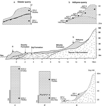
The quarry comprises (bottom upwards) a unit, 6 m thick, of medium grained, porous limestone with low-angle cross bedding dipping towards the sea. This unit is overlain by a layer 50 cm thick with epikarstic features like solution vugs and channels lined with thin layers of brownish silty sand. This is succeeded by a coarse-grained, moderately sorted shell limestone unit, ~3.5 m thick, with scattered fragments of molluscan shells that make it more porous in comparison with units beneath (Fig. 3a). The upper unit is cavernous with evidence of recrystallization near its top. This feature was most probably caused by percolating meteoric waters. Overall sediment character and physical structures indicate that the lower part of this ridge was wave built that graded vertically into a wind-built ridge (Otvos, Reference Otvos2000). The wave-built part of the ridge reaches to 6 m amsl suggesting that it is an ancient shoreline about 5–6 m higher than the present sea level. Samples OD-1 and OD-2 of limestone blocks were collected for OSL dating from the upper and lower units, respectively.
Geologic profile from Porbandar to Odadar showing details of lithologs and sampling at Odadar (a), Adityana (b), Kuchdi (c), Makanpur (d), and Gop Hill (e). Numbers against the sample positions (Black squares) indicate corresponding optically stimulated luminescence age.

Adityana
Several miliolite quarries in obstacle dune deposits were found at Adityana (21°43.51′N, 69°41.51′E). Here the Barda Hills form a topographic break against the coastal plains of Porbandar. A sequence about 30 m thick of exposed miliolite shows five distinct stratigraphic units of aeolian accumulations and their intermittent reworking by movement towards the base under gravity and/or by fluvial activity. This is indicated by the mixing of miliolite with locally derived sand and gravels. The lowermost unit is a pink-coloured compact limestone capped by a 30 cm epikarstic layer with solution channels and vugs. This is overlain by a metre-thick unit of reworked miliolite mixed with locally derived granophyres and basalt clasts. About 3 m of buff- to white-coloured and fine- to medium-grained aeolianite sits over it and extends downslope. The top of this unit is reworked. The youngest unit is a 5 m thick, white-coloured, and fine-grained aeolianite with planar, wedge-shaped cross stratification (Fig. 1c). Figure 3b gives the stratigraphic positions of each unit together with the sample locations.
Kuchdi
About 4 km north of Porbandar, at Kuchdi (21°40.56′N, 69°32.13′E), a linear subdued ridge is a northward extension of the Odadar ridge and is being quarried (Fig. 3c). The quarry is about 5 m deep, and, like the Odadar sequence, the shell limestone comprises medium- to coarse-grained porous limestone with scattered fragments of corals and molluscs. Two blocks of shell limestone were collected from its base (KCD-1) and top (KCD-2). Sample KCD-1 is at −2 m level and KCD-2 is +3 m amsl.
Ratiya
About 30 km south of Odadar, near the Ratiya locality, is the same beach ridge involving numerous abandoned quarries. Sample RT-1 was collected from the bottom part of a quarry (2 m amsl) to date the southernmost extension of this beach ridge system.
Makanpur
This locality (22°20.23′N, 68°57.44′E) is the northernmost occurrence of typical shell limestone and is the Okha Shell Limestone Member of the Chaya Formation (Bhatt, Reference Bhatt2000). A section in a north–south trending ridge of 4 m height was available because of quarrying. The quarry face exposes a seaward-dipping, planar cross-bedded unit of coarse-grained, moderately sorted limestone with scattered lenses of beach shingle (Fig. 3d; photo 3 in the Supplementary Materials), which unambiguously demonstrates deposition as a beach. The bottom of the section is about 4 m amsl and about 650 m from the active shoreline. Two samples, MKN-1 and MKN-2, were collected from the lower and upper parts of the quarry, respectively.
Gop Hill
North of Barda Hills, the miliolite in the Gop Hill was also investigated because of its similarity with Barda Hills (photo 1 in the Supplementary Materials). An obstacle dune approximately 3 m thick rests on the southern slope of the hill, with wedge-shaped geometry. The deposit is white, well sorted, and fine grained with planar cross bedding (sample GP-1). Towards the base of the hill and at a distance of about 300 m downstream, miliolite sand mixed with significant amounts of basalt and granophyre sand and gravels with thin stratification provided a typical example of fluvially reworked miliolite (Fig. 3e). Sample (GP-2) was collected from this unit to determine the timing of the fluvial reworking event.
Mangrol-Kodinar sector
Sites in this sector were chosen to understand relative sea level changes, aeolian deposition of miliolite, and fluvial aggradation events. Five sections were selected—namely, the Mangrol coast, Kamnath temple, the Noli River bridge, the Singvado River near Kodinar, and the Umrethi dam site on the Hiran River.
Mangrol
On the Mangrol coast (21°06.59′N, 70°05.32′E), an abandoned quarry 2 m deep has typical shell limestone with macrofragments of shells and corals (photo 4 in the Supplementary Materials). Figure 4a provides the lithological succession. The ridge that hosts the quarry runs parallel to the coast and extends landwards for about 100 m. Towards the sea, the limestone unit is overlain by stabilized and seasonally active coastal dunes up to 50 m high that merge with the present-day beach. The upper part of this sequence is cavernous with solution channels that extend up to a meter in depth. The lower part of the quarry has bioherm accumulations along the sides of a dead coral reef. Towards the top this grades into a typical beach rock assemblage. The outcrop is 1 m amsl and is about 200 m from the modern shoreline. Sample MG-1 was collected from the middle of the unit where the limestone is less porous and has no evidence of weathering.
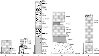
Lithologs of Mangrol coast (a), Kamnath temple (b), Noli River section (c), Ghantwad (d), and Umrethi dam site (e) showing disposition of various units and optically stimulated luminescence sample locations (black squares) along with their ages.

Kamnath
The site at Kamnath Temple (21°08.12′N, 70°10.46′E) has a sequence ~2 m thick comprising a fluvially reworked miliolite sheet. Based on the texture, three sedimentary units can be differentiated. From the base upwards, these are the following: A 130 cm thick, clast-supported conglomerate that grades to a matrix-dominated (fining upwards) sequence in its upper part (unit I); this is overlain by a 30 cm thick, fluvially reworked miliolite including Tertiary limestone boulders (unit II) together with an erosional contact with unit I. This sequence ends with a 20 cm miliolite sheet, which is micritic and compact, as is shown in thin section that also suggests its deposition as a coastal swamp (unit III). Samples MG-2 and MG-3 from unit I and unit III, respectively, were taken (Fig. 4b) to date the fluvial aggradation and deposition of miliolite events.
Noli bridge
The site at the Noli River bridge (21°05.50′N, 70°09.23′E) is a cliff section ~6 m thick and comprising five units. From the base upwards, the older miliolite contains abundant oyster shells (photo 5 in the Supplementary Materials) with convolute bedding. The upper layers of convolute bedding are partially eroded and are covered by a subhorizontal horizon of miliolite. This unit is overlain by a pebbly, 1 m thick, stratified horizon (unit I) overlain by a partially eroded horizontal to subhorizontal miliolite layer 40 cm thick (unit II). Unit II is topped by about 1.5 m of reddish-brown sandy gravel (unit III). Overlying this is a 1 m thick, mottled, well-sorted sandy horizon with faint cross stratification containing calcrete (unit IV).The uppermost unit (unit V) is a miliolite 30 cm thick with gentle inclination towards the northwest. Sedimentary structures suggest that units I, II, III, and IV were deposited in a fluvial environment and that unit V was deposited in an aeolian environment. Figure 4c depicts the stratigraphic units in this section along with the locations of the OSL samples. Overall, these units suggest marine intertidal deposition at the base grading upwards to fluvial deposits overlain by an aeolian deposit.
Ghantwad
Site 4 is about 16 km north of the Kodinar and near a village called Ghantwad (20°55.33′N, 70°45.31′E) in the Singvado River basin, where a riverbank section of ~5 m height was available (Fig. 4d). Here the miliolite rests on a soil, 0.5 m thick, developed on basalt. The sequence contains 6–8 m thick, near-homogeneous deposits of miliolite on both riverbanks. The rock is pinkish in colour, very fine grained, and compact. Low-angle planar and trough cross stratification, thin lenses of basalt sand and gravels, and crescent ripple marks were seen in the exposure. Sample (KDR-1) from the upper part of the miliolite sequence was collected for OSL dating.
Umrethi
On the downstream side of the dam on the Hiran River, near Umrethi (21°01.17′N, 70°28.13′E), is a section approximately 6 m thick exposing two distinct units of miliolite (Fig. 4e; photo 6 in the Supplementary Materials). The lower 2 m comprises very fine-grained, white-coloured limestone with a dune form exhibiting polygonal cracks and ripples in its upper part. Sample UMT-1 was collected from this unit. This unit is separated from the overlying unit by an erosional unconformity, which comprises 4 m of wedge-shaped, planar cross-stratified, well-sorted sand of aeolian origin. Sample UMT-2 was collected from the lower part of this unit.
Diu-Una-Gopnath sector
Samples in this sector were taken to understand the chronology of coastal aeolianites with regard to sea level. A total of five sections were examined. From west to east, these were Nayda caves, Phudam (Diu), Una, Gopnath, and Mahuva.
Diu
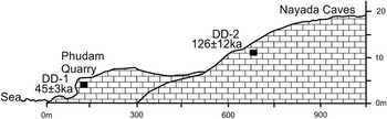
The site at Nayda caves (20°42.41′N, 70°58.53′E) to the west of Diu comprised abandoned quarries of miliolite. The quarry faces exhibit moderate- to high-angle planar cross stratifications of yellowish-coloured and medium-grained, well-sorted miliolite. A 15 m sequence of miliolite formed by stacking of two coastal dunes was seen. This was inferred from the truncation of sedimentary structures by an erosional surface. Sample DD-2 was collected from the upper part of the sequence. About 1 km (aerial distance) from this site towards the south at Phudam village, an abandoned quarry exposed a 12 m thick, white-coloured, medium- to fine-grained, moderately sorted miliolite with large-scale, wedge-type planar cross bedding. In its upper part, the dune sequence exhibits ripple laminations and horizontal bedding in a deposit, 70 cm thick, formed by syndepositional coastal flooding (photo 7 in the Supplementary Materials). Sample DD-1 was collected from the upper part of the quarry, which is at 5 m amsl. Figure 5 exhibits the stratigraphic relation between these two sample sites.
Geologic section along west–northwest to east–southeast between Nayda caves and Phudam in Diu showing optically stimulated luminescence (OSL) sample positions. The black squares show the OSL sample locations and their ages.

Una
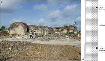
On the road between Kodinar and Una, several mounds of aeolianite occur on the coastal plain. These are parabolic and longitudinal dunes made up of very fine-grained, well-sorted, white miliolite and exhibit curved dune bedding with an average dip azimuth of N80°E indicating a westerly transport direction. On the road to Una, north of Diu island, a quarry (20°48.22′N, 70°57.19′E) exposes a 15 m sequence comprising dirty-white-coloured, well-sorted miliolite with moderate- to large-scale cross stratification within a parabolic dune form (Fig. 6a). Here two distinct units are stacked one above the other with an erosion surface in between. Sample UNA-1 was collected from the base of the section, and sample UNA-2 was collected from the upper unit (Fig. 6b).
(color online) (a) Field photograph showing active quarrying of miliolite in a parabolic dune deposit near Una. The bottom of the quarry is at about 30 m above mean sea level. Height of persons standing is 162 cm. (b) Position of litholog of the section showing positions of optically stimulated luminescence samples (black squares) along with their ages.

Gopnath
The site at Gopnath (21°12.22′N, 72°06.35′E) is at the southeastern corner of the Saurashtra peninsula and is the farthest eastward occurrence of miliolite. From this point onwards, only sandstone and conglomerate units of Miocene age occur. Coastal cliffs attain a height of about 12 m and expose three distinct miliolite units separated by 0.5–1 m thick, red soil layers (Fig. 7a and b). The limestone units show curved dune bedding and parabolic dune geometry. Three samples from the limestone units (GPN-1, 3, and 5) and two samples of red soil units (GPN-2 and 4) were collected.
(color online) (a) Coastal cliff section at Gopnath showing positions of optically stimulated luminescence (OSL) samples and various miliolite units with intercalated palaesol horizons. Height of the person standing is 168 cm. (b) Litholog with details of OSL samples and ages (black squares). The base of the litholog is the high-tide level.

Mahuva
The coastal area of south Saurashtra also consists of stabilized, friable carbonate dunes, devoid of sedimentary structures and confined to the indentations on an otherwise clifflike coast. These represent the most recent dune-building phase in the region. Sample (MVA-1) was collected from the coast at Mahuva (21°03.54′N, 71°48.22′E) near the Bhavani temple 1 m amsl from a cliff formed by erosion of the stabilized coastal dunes (photo 8 in the Supplementary Materials).
Inland occurrences
Anandpur
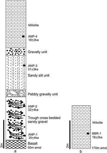
The Ojat River is the third-largest river of Saurashtra. At Anandpur (21°03.54′N, 71°48.22′E), the riverbank exposes a sequence, 9 m thick, of fluvial gravels and sand overlain by miliolite. The sequence rests unconformably on weathered basalt. The lowermost unit is a 2 m thick, compact, trough cross-bedded gravel, and, in its upper part, assorted pebbles and gravels show crude horizontal layering. This unit is overlain by a silty sand unit, 4.5 m thick, with horizontal stratification in its lower part and low-angle planar cross stratification in the upper part (Fig. 8a; photo 9 in the Supplementary Materials). A lens approximately 50 cm thick of gravelly sand occurs over the silty sand unit that is laterally discontinuous. This is unconformably overlain by sheets of miliolite that are 0.5 and 2 m thick. These units were described as trough cross-bedded gravel, planar cross-stratified sand, and massive sand facies by Bhatt and Bhonde (Reference Bhatt and Bhonde2003). The presence of calcretized rhizomorphs indicates that the surface was vegetated. Figure 8a depicts the position of samples for OSL dating.
Lithologs of Anandpur (a) and Bamanbor (b) showing details of sediments and optically stimulated luminescence (OSL) sample sites. Black squares are the location of the OSL samples with their ages.

Bamanbor
About 20 km west of Chotila (~160 km from the sea), Bamanbor (22°25.08′N, 71°02.05′E) is the farthest inland occurrence of miliolite and has been described by Brückner et al. (Reference Brückner, Mangini, Montagioni and Rescher1987) and Baskaran et al. (Reference Baskaran, Rajagopalan and Somayajulu1989). Patchy valley-fill miliolite is confined to second-order seasonal streams amidst the basalt hillocks. The miliolite unit lies unconformably on basalt and has a thickness of <3 m. The miliolite is white coloured, well sorted, and fine grained with planar cross bedding and dip azimuths towards the valley slope. Towards the valley floor, it exhibits a network of rhizocretions. Within the unit, scattered lenses and thin layers of angular basalt fragments occur, and most likely, these were derived from the adjacent hills. Sample BBR-1 was collected from the lowermost part of an abandoned quarry face exposing a miliolite unit ~2.8 m thick (Fig. 8b).
Chronology using optically stimulated luminescence
The physical nature of samples dictated the manner of sample collection for OSL analysis. For consolidated rocks, large blocks (50×50×50 cm) were taken, and for friable samples, standard steel pipes were used (Chandel et al., Reference Chandel, Patel, Vaghela and Ubale2006). A total of 15 sites and 42 OSL samples were analysed. The choice of analysis protocol was determined by the mean grain size of the clastic grains, and accordingly, either of the coarse- or fine-grain techniques were used (Aitken, Reference Aitken1985).
An important aspect of the application of OSL was to ascertain if the carbonate coating on quartz grains was postdepositional or that the grains had a carbonate coating at the time of transport and deposition. This is because the overall opacity (because of carbonate coatings) would have determined the ease of bleaching of the preexisting OSL signal in the quartz grains. The presence of micrite and sparite as cement in miliolite samples suggested that the carbonate coating was authigenic (i.e., postdepositional). In thin sections (Fig. 1b and d), the quartz grains show sharp contact with the microcrystalline cement, which also suggests that these grains did not have carbonate coatings prior to deposition. Surface texture studies using scanning electron microscopy also indicated abrasion of the quartz and carbonate grains (Bhatt and Patel, Reference Bhatt and Patel1998b; Bhatt, Reference Bhatt2003). We surmise that during their transportation with bioclastic carbonate grains or during reworking in intertidal regions, the quartz grains lost any carbonate coatings on them by mechanical abrasion. Thus, the absence of coatings at the time of transport and deposition and multiple reworking in the intertidal region facilitated total bleaching of their OSL. This inference accords with the results of Rink (Reference Rink1999) and Murari et al. (Reference Murari, Achyuthan and Singhvi2007) and is supported by the experimental data on the distribution of doses.
Extraction of quartz grains from the carbonate blocks was carried out under filtered red light. Experiments on blue light penetration using slices of carbonate blocks indicated that the light did not penetrate beyond a depth of 2 cm. Therefore, the outer 5–7 cm of the blocks was removed by a stonecutter with water cooling. The interior was broken into small fragments and pretreated with 1N HCl until complete dissolution of carbonates occurred and only the residual detritus was left. This process took up to a week and needed repeated acid treatments. Subsequent treatment followed established procedures for coarse and fine grains and is given in the OSL methodology in the Supplementary Materials.
Typically, about 15 to 40 aliquots per sample were measured for D e . At times the yield of quartz was low, and therefore, at times only a limited number of discs were available for analysis. The choice of the model for the D e calculation was based on overdispersion and published accounts of the distribution of doses because of the heterogeneous distribution of beta doses (Mayya et al., Reference Mayya, Morthekai, Murari and Singhvi2006; Chauhan and Singhvi, Reference Chauhan and Singhvi2011). We were also guided by the work of Bailey and Arnold (Reference Bailey and Arnold2006).
Mayya et al. (Reference Mayya, Morthekai, Murari and Singhvi2006) and Chauhan and Singhvi (Reference Chauhan and Singhvi2011) quantified random spatial variations in the quantity and distribution of the 40K-bearing feldspar grains that lead to a distribution in doses in adjoining quartz grains. To account for this heterogeneous distribution of radiation dose rate, the uniform dose deposited by U, Th, and gamma radiations from 40K was removed, after which the ratio of maximum and minimum doses was used to decide on the bleaching status. If the ratio was explained by heterogeneity in the beta dose, the sample was considered to be well bleached, and, if not, then partial bleaching or sediment mixing was inferred. As anticipated, most samples were found to be well bleached (Rink, Reference Rink1999; Murari et al., Reference Murari, Achyuthan and Singhvi2007). Overdispersion ranged from 2% to 35% (mostly 30%), and, therefore, the central age model was used. The saturation dose typically ranged from 150 to 270 Gy, and this limited the ages to about 170 ka. The annual dose rate being a fraction of Gy/ka helped.
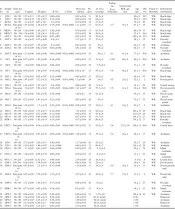
The annual dose rate was computed using the elemental concentrations of potassium, thorium, and uranium and an adopted water content of 5%. The cosmic ray contribution to dose rate was computed using Prescott et al. (Reference Prescott, Huntley and Hutton1993). Use of the 5% value for average water content was guided by the following considerations: (1) the annual rainfall in the region is ∼500–700 mm/yr, the rain occurs over a few spells during 3 months/yr, and, during the remaining 9 months, the region remains bone dry; (2) the deposits are well drained; (3) carbonate cementation does not allow much percolation; and, (4) at the time of collection, most samples were dry or weakly moist to the level of moisture in sands from stable sand dunes. The maximum water-holding capacity as estimated from thin sections was 6% to 10% of volume and laboratory measurements indicated it to be 4% to 5%. Thus, the use of the 5% water content is justified. We also consider that none of the major inferences of this study will be compromised if the water content were to be somewhat higher.
From the available options for the estimation of elemental concentrations of U, Th, and K, gamma ray spectrometry was preferred. Other methods such as neutron activation analysis or destructive chemical analyses use small samples compared with gamma ray spectrometry that provides better representation of the average dose rate. Gamma ray spectrometry also enabled measurement of the activity of individual radionuclides in the decay chains. An ultralow-background gamma ray spectrometer with an active volume of 148 cc and housed inside a lead shield, 10 cm thick, was used. In the present study, an instrumentation-based limitation was that the equilibrium between the 238U to 226Ra could not be measured because of difficulties in measurements of the 63 keV gamma ray of 234Th (234U) in the decay of 238U.
The protocol for gamma ray spectrometry measurements is given in the methodology in the Supplementary Materials. Despite the fact that earlier studies used the 238U/230U disequilibrium for age calculation, a radioactive equilibrium was assumed based on the observations that (1) we did not observe any gross disequilibrium from 230Th to 214Bi, and (2) most of the gamma dose was post-230Th, and about 75% of the beta dose that accrues from U is also post-230Th (Aitken, Reference Aitken1985). The total beta and gamma doses from the potassium range from 10% to 50%. Thus, possible radioactive disequilibrium ranges from 50% to 90%. Typically, the total beta doses from U and Th, pre- and postradon, are 33% and 39%, and similarly, the gamma doses are 37% and 21%, respectively. Given that ~50% of the dose comes from decays between 230Th and 220Rn, the dose potentially contributed by the decay sector 238U-230Th is estimated to be 20% or less, and this will not fundamentally alter the inferences from the present study.
Results
In the study area, carbonate sedimentation occurred in three distinct depositional environments: (a) coast fringing shell limestone, (b) coastal and inland aeolianites (miliolites), and c) fluvially reworked sheet deposits of impure miliolite.
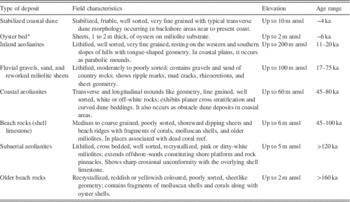
Table 2 provides the basic data comprising D e estimates; concentrations of K, Th, and U; and the inferred bleaching status. Typical dose distribution histograms, dose plateau, and dose recovery data are provided in the Supplementary Materials. The ages ranged from >165 to 44 ka for the shell limestones, 75–17 ka for the fluvially reworked miliolite deposits, and 80–11 ka for miliolites deposited by aeolian processes. These age ranges suggest that all processes of deposition were approximately coeval. However, at a more detailed level, it was seen that the carbonate sediment generation occurred during higher sea level stands (100–80 ka, 44 ka) with which the near-coast aeolian processes were coeval, and the inland aeolianites were deposited during the period of lower sea level (18–11 ka). Fluvial reworking events (50ka, 30ka) punctuated the phases of aeolian deposition, indicating short-duration humid runoff interludes. Table 3 summarizes field observations in terms of deposition of carbonate sequences, their characteristics, and OSL ages.
U, Th, and K concentrations and optically stimulated luminescence data.

Notes: The elemental concentration of K was estimated using the 1460.75 keV gamma line of 40K; for Th concentration, the 583.1 keV gamma line from 208Tl; and for U concentration, the 609.3 keV gamma line from Bi 214. Water content, 5%; cosmic ray dose, 150±15 μGy/a. OD (%) after Bailey and Arnold (Reference Bailey and Arnold2006); extent of bleaching after Chauhan and Singhvi (Reference Chauhan and Singhvi2011). IRSL, infrared-stimulated luminescence; Not applicable; Over-dispersion; WB, well bleached.
Summary of the types of Quaternary carbonate deposits and their optically stimulated luminescence age ranges in the study area.

Note: amsl, above mean sea level.
a After Juyal et al. (Reference Juyal, Pant, Bhushan and Somayajulu1995).
Discussion
Carbonate depositional environments
The event stratigraphy of the carbonate deposits of Saurashtra has long been debated because of their bioclastic composition and suggestions of their deposition under a shallow marine environment linked with contemporary sea levels. As U-series ages of such deposits did not accord with the global sea level history, neotectonic uplift of the Saurashtra peninsula by >200 m at an average rate of 0.23–2.0 mm/yr was suggested by Baskaran et al. (Reference Baskaran, Rajagopalan and Somayajulu1989). However, such rates of uplift and total uplift of >200 m are not realistic as there is no geomorphic signature of uplift that should have come about as a consequence.
The geometry of sediment bodies, physical structures, micromorphology, and cement mineralogy suggest three events of carbonate deposition—namely, (1) near-coast intertidal to supratidal deposition (dead coral reefs, shell limestone, and coastal aeolianites); (2) inland deposition as obstacle dunes (inland aeolianites) resting on basalt/granophyre hill slopes; and (3) deposition as fluvially reworked valley fills and riverbank sheet deposits (gravels and pebbles of older rocks embedded in miliolite). Occurrences of miliolite near the coast extend offshore as rocky shore platforms and as submerged aeolianites. Shore-parallel beach ridges, associated dead coral reefs, and lagoon sediments in interdune depressions of the coastal areas are the marine components of the carbonate sequences and should reflect higher sea levels (Brückner et al., Reference Brückner, Mangini, Montagioni and Rescher1987; Bhatt and Patel, Reference Bhatt and Patel1998a).
Occurrence of macrofossils such as Tellina, Cerithium, Ostrea, and Arca in the lower parts of the shell limestones, along the Porbandar-Mangrol segment, led Brückner et al. (Reference Brückner, Mangini, Montagioni and Rescher1987) to infer a low-energy lagoonal environment. The absence of shell limestone and macrofossils in carbonate units above 10 m amsl, in a coastal belt ~1 km wide, limits the extension of higher sea levels in the region. The coastal aeolianites were deposited as backshore dunes in coastal areas associated with higher sea levels.
Inland occurrences exhibit sedimentological characteristics typical of aeolian deposition, which at times was reworked by local fluvial action to form patchy outcrops of valley fills and riverbank sheet deposits. Such spatially extended, littoral to backshore, and far inland depositional events were linked to the relative changes in sea level. Obstacle dunes, valley fills, and fluvial sheets formed by reworking of coastal miliolite sediments during arid periods.
Using contemporary literature, Singhvi et al. (Reference Singhvi, Bhatt, Glennie and Srivastava2012) correlated the phase of major coastal aeolianite building with Marine Isotope Stage (MIS) 7, which was overlain by the shell limestone of MIS-5 with an erosional surface linking with a relative lower sea level (MIS-6). However, in the absence of firm geochronological data, their inference was only indicative.
OSL ages of carbonate deposition
Earlier, the deposits were dated by 14C, 230Th/234U, 234U/238U, and ESR methods. These techniques gave the age of the bioclasts. Diagenetic alterations of these deposits through meteoric waters made the deposits open systems, and hence their use led to erroneous interpretations (Gupta, Reference Gupta1991). In general, the OSL ages are younger than both the radiometric and radiocarbon ages, confirming that radiometric ages provide ages of parent carbonate that were substantively but variably modified by diagenesis. The OSL chronology (Table 2) indicates a spread of ages from 174 to 11 ka. The OSL ages are stratigraphically consistent and therefore enable construction of a plausible scenario of landscape evolution, as discussed subsequently. Further, the oldest OSL age is 174 ka, whereas the radiometric ages of Baskaran et al. (Reference Baskaran, Rajagopalan and Somayajulu1989) and Brückner et al. (Reference Brückner, Mangini, Montagioni and Rescher1987) extend to 270–200 ka. This could in part be attributable to saturation of the OSL signals of quartz that limits the age to 200 ka or thereabouts. It is pertinent to note that at Porbandar the radiometric age by Brückner et al. (Reference Brückner, Mangini, Montagioni and Rescher1987) on parent carbonate grains (cement removed) of 95 ka (123.2–72.6) accords well with the OSL age of 99±8 ka for the same stratigraphic unit.
OSL ages of miliolite from the Umrethi site provide an age of 150±12 ka for Lower to Middle Palaeolithic tools, an age span that is similar to age estimates (130 to >180 ka) from the Thar Desert (Singhvi et al., Reference Singhvi, Williams, Rajaguru, Misra, Chawla, Stokes, Chauhan, Francis, Ganjoo and Humphreys2010). Baskaran et al. (Reference Baskaran, Marathe, Rajaguru and Somayajulu1986) suggested that the age of the Lower Palaeolithic industry in Saurashtra has an age of between 69 and 190 ka.
At Mangrol, an older shell limestone (with oysters) forming the substrate of the Noli River section was dated to 165±15, 163±13, and 158±11 ka (MG-9, 10, and 11); whereas, at the Singvado River, the oldest miliolite deposition was at 174±12 ka (KDR-1). In the Adityana area, the oldest dune-building activity was at 140±16 ka (ADT-1). These ages suggest the occurrence of cyclic events of carbonate generation and reworking environments in the region prior to 130 ka.
Past sea levels
Relative sea level changes based on the coastal sedimentary records of Saurashtra and also from offshore areas have been examined by earlier workers (Juyal et al., Reference Juyal, Pant, Bhushan and Somayajulu1995; Rao and Wagle, Reference Rao and Wagle1997; Bhatt and Patel, Reference Bhatt and Patel1998a; Mathur and Pandey, Reference Mathur and Pandey2002; Rao et al., Reference Rao, Rajgopalan, Vora and Almeida2003; Mathur et al., Reference Mathur, Pandey and Bahadur2004). A higher sea level during MIS-5 (~120 ka) and a falling trend after a Holocene high sea level since 6 ka were suggested (Mathur et al., Reference Mathur, Pandey and Bahadur2004).
The OSL ages from the shore/marine shell limestone at Odadar (99±8 to 80±8 ka), Makanpur (84±10 to 75±7 ka), Ratiya (81±5 ka), Kuchdi (78±8 to 67±5 ka), and Mangrol (44±4 ka) reflect a higher sea level stand of approximately +6 to 8 m during the time periods of 100–70 ka and 44 ka. These conclusions are consistent with global high sea level stands (Martinson et al., Reference Martinson, Pisias, Hays, Imbrie, Moore and Shackleton1987). Also, Bhatt et al. (Reference Bhatt, Murari, Ukey, Prizomwala and Singhvi2016) reported a tsunamite deposit with an OSL age of 35.4±4.3 ka within a beach ridge that has been constructed since 48.3±9.9 ka. Deposition of large tsunami boulders at +8 m elevation could have occurred only under conditions of a high sea level stand at ~ 45 ka.
Higher sea levels in the study area are also recorded as shore-parallel, high-level beach ridges and tidal notches (Pant and Juyal, Reference Pant and Juyal1993; Bhatt and Bhonde, Reference Bhatt and Bhonde2006). However, such coastal geomorphic features do not extend beyond 8 m amsl. Although Shackleton (Reference Shackleton1987) suggested a 19 m lower sea level around 80 ka, Ludwig et al. (Reference Ludwig, Muhs, Simmons, Halley and Shinn1996) reported higher sea level at 2 m amsl at the same time from the tectonically stable platform of Florida and Bermuda. Otvos (Reference Otvos2015), in his review of the last interglacial stage in North America and Eurasia, presents similar observations. Lewis et al. (Reference Lewis, Sloss, Murray-Wallace, Woodroffe and Smithers2013) also concluded that sea level behaved differently at different locations along the Australian coast because of site-specific geomorphic controls.
Though a last interglacial high stand at ca. 120 ka (corresponding to MIS-5 of Shackleton [Reference Shackleton1987]) was documented in Saurashtra at the Chikasa locality by Juyal et al. (Reference Juyal, Pant, Bhushan and Somayajulu1995), a finer differentiation between the substages MIS 5e, 5c, and 5a has not been possible because of resolution of OSL ages and the fact that beach rock can be deposited from intertidal to supratidal levels without offering a dependable indicator of mean sea level, unlike the vertex of a tidal notch (Bhatt and Bhonde, Reference Bhatt and Bhonde2006).
Past aeolian activity
A comparison between radiometric ages and the OSL ages shows that in coastal areas near sediment sources both radiometric and OSL ages agree, whereas for inland or reworked deposits the difference in the two types of ages is significant. Three distinct geologic processes experienced by carbonate sand are as follows: (1) generation of carbonate sand during high sea levels (warmer climate) with an increase in bioproductivity resulting in the generation of large amounts of bioclastic carbonates; (2) winnowing of this sand from the intertidal areas and deposition of well-sorted carbonate sand on the coast forming backshore coastal dunes because of the availability of ground moisture in a warmer climate; and (3) reworking of the deposited carbonate sand and its transport inland during arid intervals coeval with falling sea level. A further fall of sea level does not favour biological productivity, and thus, sand supply is curtailed leading to wind erosion and transport of carbonate sands. The timing of major phases of aeolian activity (coastal and inland aeolianite) approximately parallels those in the Thar Desert where Singhvi and Kar (Reference Singhvi and Kar2004) report episodic aeolian accumulation at 150 ka, 115–100 ka, 75 ka, 55 ka, 30–25 ka, and 13 ka. In the present study, aeolian events cluster at >174–156 ka, ~80 ka, 50–45 ka, and ~18–11 ka suggesting that they are governed by the same southwest monsoon wind system and preservation system as in the core Thar Desert, and minor differences in timing arise because of spatially varied preservation conditions.
Aeolian and fluvial reworking events are seen in the younger ages of inland aeolianites, obstacle dune deposits, and fluvial reworked sheets. These ages range from 20 to 11 ka (Table 2; sample nos. UNA-1, UNA-2, ANP-4, BBR-1, GP-2, and MG-3). In coastal areas, the OSL ages of beach rock are closer to those of the coastal aeolianites and generally coincide with higher sea level stands (Table 2; sample nos. OD-1, OD-2, KCD-1, KCD-2, MKN-1, MKN-2, RT-1, MG-10, MG-11, ADT-1, ADT-5, ADT-4, DD-2, DD-1, and GPN-5). Out of these, the Gopnath sample (GPN-5), on the eastern side of Saurashtra, represents the oldest coastal dune deposition (156±14 ka). The sedimentological characteristics and form of these dunes samples reveal them to be parabolic dunes (Khadkikar, Reference Khadkikar2004), and this dune field formed a large coastal oasis ecosystem as suggested by Costa (Reference Costa2015).
Major dune deposition that occurred at 77±5 ka to 43±3 ka (ADT-5 and ADT-3) is indicated by the significant thickness of aeolianites reaching up to 40 m amsl because of higher sediment supply from the preceding high sea level phase.
Younger ages of inland obstacle dunes suggest a longer period of reworking (18±2 ka, ANP-4; 18±2 ka, BBR-1). Overall, the aeolianites of the inland Saurashtra suggest extension of the dune-building phases of the Thar Desert, though limited in extent by availability of carbonate sand in Saurashtra.
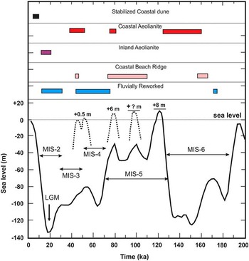
Figure 9 summarizes the timing of deposition of coastal beach ridges, coastal aeolianites, inland aeolianites, and fluvial reworking of aeolian deposits in comparison with global sea level changes. Deposition of coastal carbonates (shell limestone) occurred during the time interval 100–75 ka (i.e., MIS-5). However, the oldest coastal deposits (>160 ka) occur in the subsurface overlain by younger phases (e.g., in Noli River sample nos. MG-9, MG-10, and MG-11 or coastal aeolianites at Gopnath). Ages of the beach ridges and coralline limestone range between 100 and 75 ka. Aeolianite deposition took place around 75 ka and 18 ka suggesting deposition during the transition from a warm semiarid climate, with a relative high sea level, to a cold arid climate with a relative low sea level towards the end of MIS-5 and a rebuilding of wind strength towards the end of the MIS-2. In the last case, the carbonate sediment supply was reduced, and sediments suffered several episodes of reworking. A sample of stabilized coastal dune from the Mahuva coast indicates similar conditions in the Middle Holocene (~4 ka) that followed the relative high sea level in the region as indicated by the occurrence of oyster beds (6.4 ka; Juyal et al., Reference Juyal, Pant, Bhushan and Somayajulu1995).
Optically stimulated luminescence ages of the coastal beach ridge, coastal aeolianite, inland aeolianite, and fluvial reworked type carbonate deposits from Saurashtra compared with the global sea level curve of Martinson et al. (Reference Martinson, Pisias, Hays, Imbrie, Moore and Shackleton1987). Curves pertaining to higher sea levels made with dotted lines are after Wehmiller et al. (Reference Wehmiller, Simmons, Cheng, Edwards, McNaughton, York, Krantz and Chou2004) and Mallinson et al. (Reference Mallinson, Burdette, Mahan and Brook2008). LGM, last glacial maximum; MIS, Marine Isotope Stage.

Conclusions
This study permits the following conclusions:
-
∙ Biogenic carbonate deposits of the Saurashtra coastal region archive a complex interplay of relative sea level and climate changes, and though the sediments were generated in shallow marine conditions, they subsequently experienced a variety of modes of transport and redeposition.
-
∙ Shore-parallel beach ridges and their occurrence at similar elevations, as well as their absence in typical marine/shore deposits above 10 m amsl, unambiguously rule out the suggestion of uplift of the Saurashtra peninsula by about 200 m during the late Quaternary.
-
∙ The inland occurrences of miliolite represent aeolian reworking of coastal sediments mixed with detrital grains from other sources during drier periods. Punctuations in the record were marked by local fluvial reworking of the miliolite. The nature of the sediments and the fact of its reworking and diagenesis restrict application of radiometric chronology using 14C and 230Th/234U methods.
-
∙ OSL ages indicated that the carbonate sediment generation occurred during high sea level stands of +6 to 8 m at 100–80 ka and 44 ka. These were coeval with near-coast aeolian processes, whereas the inland aeolianites were deposited during the period of lower sea level (18–11 ka). Fluvial reworking events at 50 ka and 30 ka punctuated phases of aeolian deposition, indicating short humid runoff interludes.
-
∙ The OSL chronology from detrital quartz represents the age of the most recent sedimentation event, and not that of its origin, proving the value of the method in this location in resolving a long-standing geosciences debate.
-
∙ A Lower Palaeolithic industry in Saurashtra dates back to >150 ka.
Acknowledgments
We dedicate this manuscript to the contributions of Prof. S.S. Merh and Dr. U.B. Mathur to recognize their seminal contributions to Quaternary studies in India. KS thanks the Kangwon National University for permission to work in India, and the Physical Research Laboratory and the M.S. University of Baroda for laboratory facilities. NB acknowledges the Ministry of Earth Sciences (MoES) for partial support for fieldwork. AKS thanks the J.C. Bose fellowship from the Department of Science and Technology, Government of India, and the Raja Ramanna Fellowship, Department of Atomic Energy, which enabled him to provide financial support to KS and cover the field trip costs. The authors acknowledge Dr. Navin Juyal for useful discussions. Dr. Vishal Ukey and Kushal Chavare kindly helped in the field. Shannon Mahan, an anonymous reviewer, editor Prof. Lewis Owen, and associate editor Prof. J. Shulmeister kindly provided constructive reviews that helped improve the presentation and organization of the manuscript substantively. We are grateful to Prof. R.J. Wasson and Prof. E. Derbyshire for their kind help with English.
Supplementary materials
For supplementary material/s referred to in this article, please visit https://doi.org/10.1017/qua.2016.12