1. INTRODUCTION
The author has long been interested in the Western Australian coastline as a result of many visits to family and friends in Perth. For sailors, it has always been a challenging, even a hostile, shore and particularly so for the early navigators with their unreliable charts and primitive technology. In this paper, the author looks at the navigational achievements of William Dampier, the first Englishman to explore systematically any of the coastlines of what was then known as New Holland.
Prior to Dampier's visits, this coast was known to ships of the Dutch East India Company en route to Batavia, although mainly as a danger to be avoided. In this, they were not always successful as ships such as the Batavia (1629), the Vergulde Draak (1656), the Zytdorp (1712) and the Zeewijk (1727) found to their peril. However, in an unwelcome English first, the Tryall, a British East Indiaman under Captain Brooke, actually began this tally of strandings in 1622. The wreck of the Tryall had disgraceful consequences although not as disgraceful as those that followed that of the Batavia. But those are other stories.
Each of these ships had been following the route from the Cape of Good Hope to Batavia (present day Jakarta) devised in 1611 by the Dutchman, Henrik Brouwer (later a Governor General in Batavia). After rounding the Cape, ships edged southwards into the belt of strong westerly winds known as the “roaring forties”, and then, after some 1000 leagues (3000 miles), turned northwards to make use of the northerly flowing branch of the South Indian Ocean circulation, and finally they picked up the South-East trade winds to the Sunda Strait. The Brouwer route must rank as one of the greatest contributions that a navigational concept ever made to commerce. It could shorten a voyage to the Indies by as much as six months as compared to the old Arab and Portuguese route which required ships to follow the East African coast through the Mozambique Channel against strong South-going currents and then across the North Indian Ocean, often via India or Ceylon (see Figure 1).
The Brouwer Route.

Captain Humphrey Fitzherbert, in 1620, was the first Englishman to follow the Brouwer route in the East India Company ship The Royal Exchange. It was a successful voyage but, later, Captain Brooke unjustly accused Fitzherbert of incorrect charting and blamed him for the loss of the Tryall. Whatever the case, after the Tryall disaster, British ships mostly avoided the Brouwer route until William Dampier followed it again in 1699.
2. PRELUDE: FIRST CONTACT WITH NEW HOLLAND
William Dampier's first contact with New Holland was made during a period of his life when he was an adventurer (some would say a pirate) rather than an explorer. During this time, he circumnavigated the world in a number of stages and in a variety of craft but as, at most, a navigator rather than a captain. On his return to England, he recounted his exploits in A New Voyage Round the World (Dampier, Reference Dampier1697) which covered the years from 1679 to 1691.
In 1686, he had been navigator of the privateer Cygnet under the command of Captain John Swan. Having spent some time raiding the Spanish on the West Coast of South America, they had crossed the Pacific to Guam from where the Cygnet made its way through the East Indies and arrived at Timor at the end of 1687. By that time, Captain Swan had been murdered and replaced by Captain Charles Reed.
From Timor, on 27 December, Dampier recorded that they “stood off to the south, intending to touch at New Holland to see what that country could afford us.” In fact, they would have preferred to head west and north, but this was not possible because it was the southern summer and the season for the North-West monsoon in that area. On 31 December, in latitude 13° 20′S, they tacked towards the north to avoid running onto a shoal marked on their charts at 13°50′S (probably the Seringapatam Reef). After five hours, they tacked again to head south-south-west in an attempt to weather the shoal, but as daylight came they saw it right ahead and eventually had to pass it on the East side (see Figure 2).
Tracks of the Cygnet and the Roebuck.
Dampier noted that their charts showed the shoal not more than 16 or 20 leagues from New Holland, but he had to sail some 60 leagues to the south before falling in with it. He drew the conclusion that the depiction of New Holland on the chart was 40 leagues too far north. In defence of the unknown chart-maker, we may note that there are a number of shoals between Timor and the New Holland coast around Emerlau Point, where Dampier is likely to have made his landfall. The Seringapatam Reef and the Scott Reef are in the right latitude and some 60 leagues north of Emerlau Point, and could well have been the reefs that Dampier reported. However, further south and east are the Beagle Reef, Churchill Reef, Adele Island and Mavis Reef. Any of these might have been the reef marked on Dampier's chart at 16 or 20 leagues from the coast although none were in the latitude he reported.
It was 4 January 1688 when Dampier first sighted the coast of New Holland and he gave his latitude as 16° 50′S, the same as Emerlau Point. There being no convenient anchoring on the open shore, they headed NE by E and followed the coastline for about 15 leagues where they found “a pretty deep bay with abundance of islands in it, and a very good place to anchor or to haul ashore.” There they anchored two miles from the shore in 29 fathoms of water over good, hard sand. This would probably have been between the present Cape Leveque and the group of islands now known as the Buccaneer Archipelago.
The Cygnet remained in New Holland for over two months, during which time she was beached and careened. Dampier's shipmates were primarily aiming to make money from their voyage, but Dampier himself showed an atypical interest in observing and recording details of the local geography, the flora and the fauna. He also reported his dealings with the aborigines and he found them “the miserablest people in the world.” Perhaps fortunately for them, he saw no prospect of trading with them or exploiting them in any way.
Accordingly, having put their ship into good shape and replenished with wood and water, they set sail from New Holland on 12 March 1688 and headed northwards. They had intended making for the Cocos Islands, but the continued north-westerly winds prevented them standing so far to the west and, instead, they made their next landfall in Sumatra.
After their brief stay, Dampier presciently concluded that “New Holland is a very large tract of land. It is not yet determined whether it is an island or a main continent, but I am certain it joins neither Asia, Africa nor America. This part of it that we saw is all low even land, with sandy banks against the sea, only the points are rocky, and so are some of the islands in this bay.”
3. RETURN TO ENGLAND AND FAME
After many further adventures, William Dampier returned to England in 1691 via the Cape of Good Hope, thus completing the first of his three circumnavigations of the world. He then found time between various other adventures, to write an account of his circumnavigation in A New Voyage Round the World (Dampier, Reference Dampier1697) which was published to great acclaim (Wallis, Reference Wallis1994). Importantly, his book attracted the attention of the Admiralty and many people of influence. For example, he dined with the diarists Samuel Pepys and John Evelyn at Pepys's house in 1697. This fame led to Dampier being given a commission to command the Royal Navy ship Roebuck in 1699 with instructions to explore the East Coast of New Holland.
Dampier set out on his voyage on 14 January 1699 with a crew of 50. For various reasons, his departure had been delayed and it was too late in the season to follow his original plan of rounding Cape Horn and crossing the Pacific to make a landfall on the east coast of New Holland. Consequently, after stopovers in the Canary Islands, the Cape Verde Islands and Brazil, he proceeded, via the Cape of Good Hope (where he did not put into port) and made a landfall for his second time on the coast of New Holland in what is now Western Australia.
4. NAVIGATION INSTRUMENTS
At this stage, before going on to look in some detail at Dampier's navigation achievements off New Holland, we pause to consider the instruments that were available to him.
4.1. The Quadrant
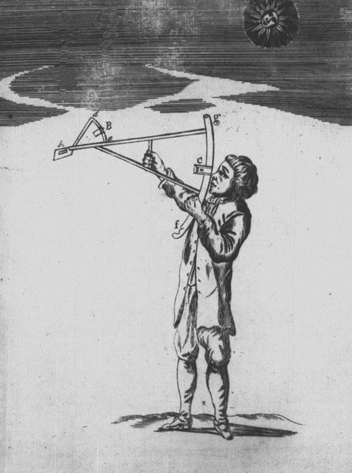
It was to be another forty years before Hadley would invent the sextant, but Dampier was perfectly well able to find his latitude by measuring the meridian altitude of the Sun. Although he does not specifically mention what instrument he used, it would almost certainly have been a development of John Davis's back-staff or quadrant, which had been in use for about 100 years. This was an unwieldy instrument to use on the deck of a rolling ship (see Figure 3) but, nevertheless, Dampier confidently (perhaps overconfidently) always quoted his latitude in degrees and minutes, and the back-staff was, in fact, so graduated.
Using a Davis Backstaff (from Moore, Reference Moore1681).
The accuracy of latitude measurements using a back-staff, based on observations by Sir Edmund Halley between 1698 and 1701, has been analysed by Forty (Reference Forty1986) to show a mean error of 1’.24 and a standard deviation of 6’.3. In practical terms this result suggests that 95% of the observations would have been within about 13 minutes of the true position. Forty's own observations, taken with a replica back-staff in 1984, gave comparable results. There is no reason to think that Dampier would have made his own observations to a lesser order of accuracy, although a study by May (Reference May1953a) of ship log books from 1741 suggests that less expert navigators at that date could be nearly 30 minutes adrift in their observed latitudes.
The back-staff allowed Dampier to find his latitude, but it was of no help to him in finding longitude. It would be another hundred years before chronometers became generally available and affordable and nearly as long before tables predicting the Moon's position became accurate enough to allow lunar distance methods to be used for finding longitude. In the meantime, he had little else to use but dead reckoning, based on his compass and the common log.
4.2. The Compass
For dead-reckoning calculations, the ship's true course through the water could be found by applying the magnetic variation to the observed compass heading and, perhaps, making an allowance for the estimated leeway. Deviation due to local magnetic effects in the ship was little understood in Dampier's time and there is no evidence in the Master's Log that he made any allowance for it. He is likely to have mostly found the variation by observing the amplitude of the Sun at rising or setting. He understood the importance of this and, unusually for his time according to May (Reference May1953a) he meticulously recorded the value of the variation in the Master's Log throughout the voyage.
Dampier gives no details of the compasses that he carried on the Roebuck but he must have had at least one azimuth compass and probably a number of steering compasses. It is likely that they would have been made by John Seller who, in 1672, obtained a contract to supply compasses to the Royal Navy (Davis and Daniel, Reference Davis and Daniel2009) a contract which was taken over by his widow, Elisabeth Seller, from 1698 to 1705 (May Reference May1953b). At that time, an azimuth compass, suitable for taking bearings of astronomical or terrestrial objects, was a relatively precise, brass instrument and a model produced by Seller was graduated so as to be read in minutes of arc (May, Reference May1973). Commander May (Reference May1953b) also tells us that, in 1707, the price of an azimuth compass was £5 as compared to a wooden box steering compass at 5 shillings. In the same paper, he also describes the construction and method of using an azimuth compass.
Ships typically had to carry many wood-box compasses because they were generally poorly constructed, poorly maintained and often defective. In 1707, around 112 wood-box compasses were returned to Portsmouth from nine ships of Sir Clowdesly Shovel's ill-fated squadron but only four were found to be completely serviceable. Many, although not all of these, were made by Seller who appears to have been something of a seventeenth century wheeler dealer (Davis and Daniel, Reference Davis and Daniel2009). A much later wood-box compass (the compass bowl still being turned out of solid wood) is shown in Figure 4. It has a card graduated in points and half points and is dated early 19th century. An older azimuth compass, similar to one that appears on the title page of Seller's book Practical Navigation (1669), is also shown.
Wood-box Steering Compass, reproduced by permission of Paul Crespel.
As Commander May noted, it was possible to observe an approximate bearing of an object by squinting across the surface of an ordinary steering compass without using any sighting vanes. Nevertheless, we can be sure that Dampier used a proper azimuth compass because he quotes his observed values of magnetic variation in degrees and minutes, an accuracy that could not have been approached using a steering compass graduated in points and quarter points and which would still be highly optimistic using a modern ship's compass. For example, Dampier said that he observed the variation by amplitude of the Sun as 6° 58′W off the Cape of Good Hope, implying an entirely unrealistic accuracy of two minutes of arc.
To be fair, Dampier himself was well aware of the inaccuracy of his estimates of variation. As was the case with many of his colleagues, Dampier could readily measure the variation by an amplitude of the Sun. That is, by observing its compass bearing at sunrise or sunset and comparing the observed amplitude with the Sun's true amplitude as found from tables. Taylor (Reference Taylor1957) tells us that the earliest English printed table of amplitudes appeared in 1664, although Thomas Hariot had, much earlier, provided a manuscript table for Sir Walter Raleigh, giving amplitudes against latitude and declination to the nearest degree.
While still near the Cape, Dampier wrote that he was not “fully satisfied as to the exactness of the taking of variation at sea: for in a great sea, which we often met with, the compass will traverse with the motion of the ship, besides the ship may and will deviate somewhat in steering, even by the best helmsman: and then when you come to take an azimuth there is often some difference between him that looks at the compass and the man that takes the altitude height of the Sun, and a small error in each, if the error of both should be one way, will make it wide of any exactness.”
This quotation shows that Dampier understood that his observations were subject to error. It also confirms that Dampier could not only use an amplitude of the Sun but that he was also able to use an azimuth of the Sun other than at rising or setting (on some days, the Master's Log records that he observed both an azimuth and an amplitude). Tables for finding an azimuth of the Sun did not become available until the nineteenth century, which suggests that Dampier was able to solve the navigator's PZX triangle. See Figure 5.
The Astronomical PZX Triangle.
When chronometers became available, the time of an observed azimuth could be used, in combination with a ship's longitude, to find the Sun's local hour angle (angle P in the PZX triangle). The complements of the ship's latitude and the Sun's declination give sides PZ and PX respectively. Then, knowing those three parts, the triangle could be solved to find the Sun's true azimuth (Angle Z). With no chronometer, and no accurate longitude, Dampier had to proceed differently. He therefore measured the altitude of the Sun (the complement of ZX) by back-staff so that, with known declination and latitude, he had the three sides of the PZX triangle and could thus calculate angle Z. As Dampier notes, the two men, at the back-staff and the compass respectively, ideally had to make their observations simultaneously.
It seems likely that Dampier found it convenient to use a simplified version of a Davis backstaff, which May (Reference May1973) calls an almicanter staff, for measuring the low altitude of the Sun near sunrise or sunset, when it was suitably placed for azimuth observations. Although Dampier himself does not mention this instrument, an “almacantas” staff was recorded as being used for this purpose during Dampier's final circumnavigation of the world under Captain Woodes Rogers (Rogers, Reference Rogers1712).
Dampier's mastery of the theory and practice of spherical trigonometry was in contrast to the lack of mathematical ability in many of his contemporaries. Richey and Taylor (Reference Richey and Taylor1962) suggest that, “Not until the middle of the eighteenth century were navigating officers in the Navy or on an East Indiaman competent mathematicians, able to use the azimuth compass frequently for such observations.” Even Samuel Pepys, the Secretary of the Navy, although educated at St Pauls School London and a Graduate of Magdalene College, Cambridge, struggled, at the age of thirty, to learn simple arithmetic (Pepys, Reference Pepys1662).
Clearly, Dampier made the best use he could of the crude and often unreliable compasses that were available to him. His courses, as recorded in the Master's Log, were usually (and realistically) given to the nearest half point, but sometimes to quarter points. On some days, and unusually for his time, he recorded the courses made good from noon to noon in degrees from the nearest cardinal point (for example E.10°N, N.41°E, W.34°S, and S.18°W). Despite such attempts at precision, the poor quality of 17th Century compasses must have limited the accuracy of his dead reckoning. In fact, compasses were to remain the Cinderellas of navigational instruments for well over a hundred years (Fanning Reference Fanning1988).
4.3. Measurement of distance sailed
If knowledge of a ship's course is the first element in dead reckoning, the second element is knowledge of the distance a ship has travelled, which Dampier found from the common log, sometimes called the English log. This consisted of a log “chip” on a line which was thrown into the sea so that the distance sailed by the ship in a known time could be measured by the length of line paid out as the ship moved away from the stationary “chip” (See Figure 6). After an initial length of stray line, the line was marked, in Dampier's day, by knots at intervals of seven fathoms. Thus, when timed by a half-minute sand-glass, the number of knots run out was taken to be equal to the ships speed in sea-miles per hour. With this spacing of knots, a speed of one knot meant that the ship travelled a distance of seven fathoms (42 feet) in half a minute and therefore 42×120=5040 feet per hour. This corresponded to a length, accepted by seamen, of 5000 feet to the sea mile.
Streaming the Log (Courtesy, Clive Kemp).
This figure was a serious under-estimate (by a sixth) of the real length of a sea mile, which is defined as the length of a minute of arc along a meridian on the surface of the Earth. By the time of Dampier's voyages, more accurate estimates had been made, in particular in 1636 by Richard Norwood (Reference Norwood1637) who had come up with a figure of 6120 feet and who consequently recommended knotting the log-line at intervals of 51 feet (8½ fathom) for use with a half-minute glass. (The modern international nautical mile is 1852 metres, or 6077 feet).
Despite these advances, Taylor (Reference Taylor1956) tells us that there were sailors who still preferred the old measurements until well into the 18th Century although, by then, they had made a gesture towards taking account of the inaccuracy by using sand-glasses which measured a shorter interval of time, typically 28 seconds instead of 30 seconds. However, Dampier specifically states that he used half-minute glasses and it is almost certain that he would have used the traditional interval of seven fathoms between knots.
David Waters (Reference Waters1956) informs us that, throughout the 17th Century, the log line was most commonly thrown every two hours and, as commander of a Naval ship, it is likely that Dampier would have followed this practice. A consequence of the close spacing of the knots in his log line was that his readings would have over-estimated the speed of his ship. This, in turn, would have led to an over-estimate of the distance travelled so that he would typically be expecting to make a landfall sooner than it was actually seen. This was considered by sailors to be a safety factor, which was probably one reason why they continued to use the seven fathom spacing of knots long after it was known to be too short.
Despite this “built in” safety factor, the opposite experience occurred for Dampier when, after crossing the South Atlantic from Brazil, he found himself ahead of his reckoning rather than behind it. This might have been due to his passage in the favourable section of the anti-clockwise current circulation of the South Atlantic.
Be that as it may, on 2 June 1699, as the Roebuck was approaching the Cape of Good Hope, Dampier saw large fowls “with white flat bills and black feathers that fly not above 30 leagues from the Cape,” while his reckoning put him 90 leagues to the westward. He was not sure whether the charted longitude of the Cape was in error or whether his reckoning was at fault because of, as he put it, “uncertainties from steerage, log, currents, half-minute glasses and sometimes want of care.” He does not specifically mention the spacing of knots in his log line although he was almost certain to have been aware that Norwood (Reference Norwood1637) had published his recommendation for a more accurate spacing some 60 years earlier.
Dampier goes on to say that most of his men who kept journals imputed the error to the half-minute glasses and he laments “indeed we had not a good glass in the ship.” Some, he thought were too short and others were too long. There are no prizes for guessing that John Seller supplied sandglasses as well as compasses to Royal Navy ships.
The fact that many of his shipmates kept their own journals conjures up the thought that navigation on the Roebuck was a game for any number of players. Dampier's egalitarian style of running his ship and the crosschecks it allowed, does seem to have been effective for the difficult task of safely navigating the Roebuck through unknown waters. His notorious inability to maintain firm discipline would have been a problem if he had been required to fight his ship, something which did not arise during the Roebuck voyage but which became evident at a later date during his second circumnavigation of the world.
However that might be, dead reckoning, which required keeping a record of the course and distance travelled, was Dampier's principal method of estimating his longitude. With a fundamentally inaccurate log line, a poorly performing compass, no means of assessing the east-west components of ocean currents and a best guess at the value of leeway, longitude error accumulated day by day and, on long voyages, could become large and unknowable.
There was, certainly, a means of estimating the north-south component of an ocean current. Neglecting leeway, the north-south, noon to noon, distance made by a ship through the water is the product of the distance by log and the cosine of the course steered. The north-south distance made over the ground in nautical miles is the difference between the observed noon latitudes in minutes of arc. The difference between these two distances gives the north-south component of whatever current is affecting the ship, although not its precise direction. The following extract from Dampier's book when he was heading south from Timor in May 1700 is illustrated in Figure 7 and confirms that he understood this perfectlyFootnote 1.
Estimating current by difference between observations and DR (Dampier's example).
“On the 26th we continued to have a very strong current setting southwardly, but on what point exactly I know not. Our whole distance by log was but 82 miles, and our difference of latitude since yesterday noon by observation 100 miles, which is 18 miles more than the whole distance, and our course, allowing no leeway at all, was South 17 degrees west, which gives but 76 miles difference of latitude, 24 less than we found by observation.”
In shallow water, it is possible to measure a current directly by streaming the log from an anchored ship or boat. The log chip would then be carried away from the ship or boat by the movement of the water. The author has only found one occasion when Dampier used this technique off the coast of New Holland. On the afternoon of August 29, he noted in the Master's Log that he, “Tried the current and found it set NW, 2 fathom in half a minute which is the rate of 7 miles in 24 hours.” This calculation confirms that Dampier was using 5000 ft for the length of a nautical mile. If he had used Norwood's more accurate figure of 6120 feet, he would have calculated the rate to be 5.8 miles rather than 7 miles in 24 hours. It would not have been practical to have anchored the Roebuck in the deep offshore water. However, Taylor (Reference Taylor1957) notes that, by the middle of the 17th Century, “it was already ordinary practice to put out in the ship's boat, let down a sea anchor, and then throw out the log to find a suspected current.” May (Reference May1973) suggests that the “sea anchor” would have comprised a large pot or kettle lowered deep down into the sea. This procedure was supposed to give the surface current but it would only have done so if there was no deep current.
4.4. Soundings
Mariners navigating north-west European waters in the 17th Century, unlike their Mediterranean counterparts, made great use of soundings measured by lead and line, and placed much importance on samples picked up from the sea bed by a tallow plug in the base of the lead (Figure 8). This method worked well for sailors who were familiar with a particular sea area. In the frequently overcast and foggy North Sea, with its numerous shoals and strong tidal steams, it was remarkably effective, but it did depend on the local knowledge of the pilots whose prodigious feats of memory more than compensated for deficiencies in charting. In fact, such methods were used at least until 1937 when a three-day voyage by a North Sea trawler was described as being conducted purely by frequent soundings (every hour or half-hour) and a magnetic compass reading quarter-points. No charts or other aids were consulted either to find the fishing grounds or to return to port (Cooper, Reference Cooper2010).
Marking of a 20th Century Hand Lead Line, little changed since.
In unknown waters, the lead could not have been used for ascertaining a ship's position. Nevertheless, it was vital for monitoring the depth of water to ensure that a ship did not run aground. Accordingly, Dampier meticulously took and recorded frequent soundings and bottom samples as he closed the land and sought anchorages, not only to ensure the safety of the Roebuck, but also to provide guidance for his successors.
He certainly used a hand lead line, probably similar to the 20 plus fathom line described by Sir Henry Mainwaring (Reference Mainwaring1644) (another ex-pirate, albeit a more successful one than Dampier). Since he reported depths of up to 85 fathoms off the coast of New Holland, Dampier must also have used a deep-sea lead line, said by Mainwaring to be thinner than the hand lead line. Even so, it would have been a major operation to heave the ship to and then let out and recover 85 fathoms of waterlogged line. The author can remember, as a cadet in 1947, repeatedly winding in over 100 fathoms of piano wire while attempting to locate the 100 fathom line as his ship approached the South-West coast of Ireland in fog. Even with two of us operating the hand-driven winch of the Kelvin machine, it was backbreaking work.
4.4. Charts
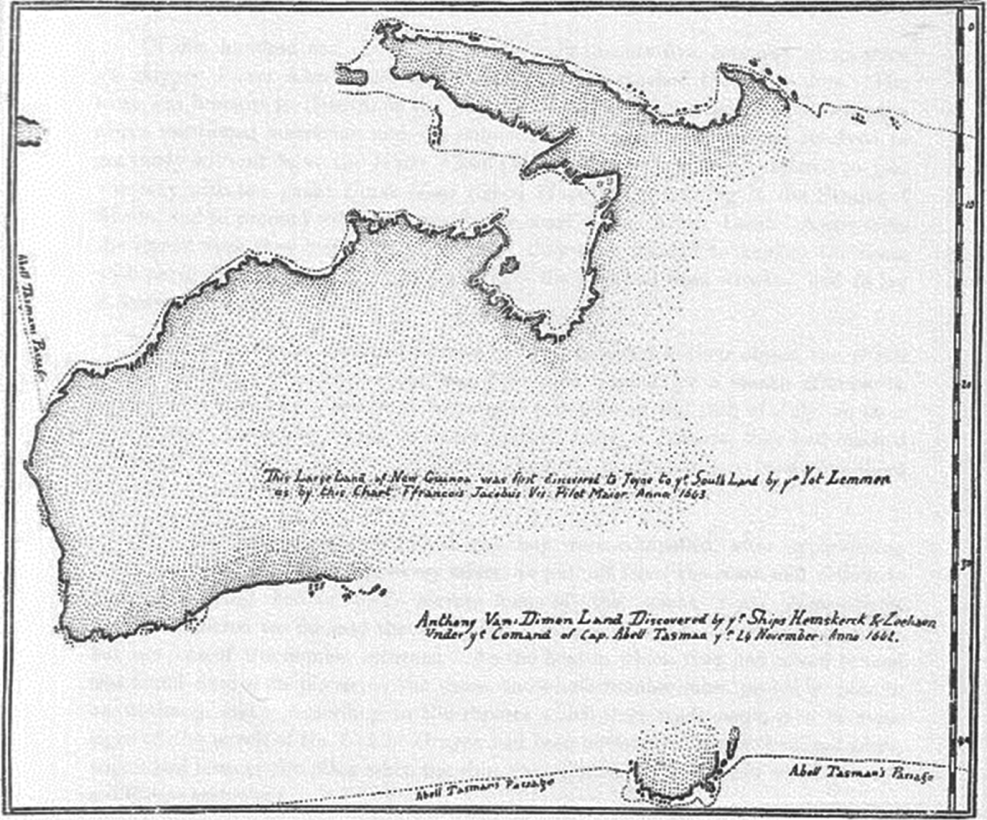
At the time of Dampier's approach in 1699, the coast of New Holland was not completely unknown. As related in Section 2, Dampier himself had briefly visited the coast in 1687, and many Dutch navigators had encountered the coast from Dirk Hartog in 1616 onwards. In his book, Dampier included a chart which contained a scale of latitude and a scale of miles but, as one would expect, no scale of longitude. He certainly had on board the Roebuck a copy of a chart made by Abel Tasman who had mapped the NW coast in 1644Footnote 2. Possibly it was the version produced by Captain Bowrey as shown in Figure 9. Bowrey had befriended an ailing Dampier when they met in Achin, Sumatra in 1688 (Dampier, Reference Dampier1697).
Map of Tasman's Route by Captain T. Bowrey c. 1687.
Whatever charts Dampier had managed to acquire would have been sketchy and incomplete, and therefore had to be used with extreme caution. Taken together with his relatively crude instruments, he faced formidable challenges and, to examine how he met them, we return to pick up his voyage as he left the Cape of Good Hope and proceeded across the South Indian Ocean towards New Holland.
5. MAKING CONTACT
The Roebuck rounded the Cape of Good Hope in company with the East Indiaman Antelope but then, on 4 June, the Antelope headed north for the old route to the Indies, while Dampier headed east-south-east on the first leg of the Brouwer route. He intended to cross the South Indian Ocean between 35° S and 40° S so as “not to stand so far North as to be within the verge of the trade-wind”. These were the south-east trade-winds which he knew would have set him away from the north and west coasts of New Holland.
It being the winter time in the southern hemisphere, Dampier was aware that he would find reliable westerly winds a little southward of the Cape, but he also knew that, had it been summer, he would have had to go southward of 40° Latitude. As it turned out, he experienced adverse winds only on 19 June and again on 4 July, by which time Dampier reckoned they were 1100 leagues east from the Cape. Seaweed and then scuttle-bones floating in the water heralded their approach to New Holland but, on 26 July, Dampier realised (from his latitude observations?) that a current was setting the Roebuck northwards and he turned to sail southwards for 24 hours before heading eastwards again. By 27 July he noted that most of the birds that had flown with the ship all the way from Brazil, had left them.
Sightings of debris in the water continued and by 30 July, the remaining original birds had left, but new and different birds were seen. The crew also noted a “rippling tide or current” but had passed it before they could sound over it.
From Noon on 29 July, when the Roebuck was in latitude 28° 36′S, Dampier says that he steered “ExS” to make sure of avoiding the Abrolhos shoal which was marked on one of his charts in latitude 27°28′S. A sharp lookout was kept and, at midnight, they observed a sounding of 45 fathoms over coarse sand and small white shells. At this point, Dampier altered course towards the South because he thought they were at the southern edge of the Abrolhos Shoal. However, by 0100 on 30 JulyFootnote 3, they sounded again and found only 25 fathoms of water over coral rock. Realising that the Roebuck must be on the north side of the Abrolhos rather than on the south side, Dampier tacked and stood towards the north. He was relieved when soundings every hour showed increasing water depths so that, by 0500, he had 45 fathoms over coarse sand and shells, indicating that they were clear of the shoal (see Figure 10).
Dampier's approach to New Holland.
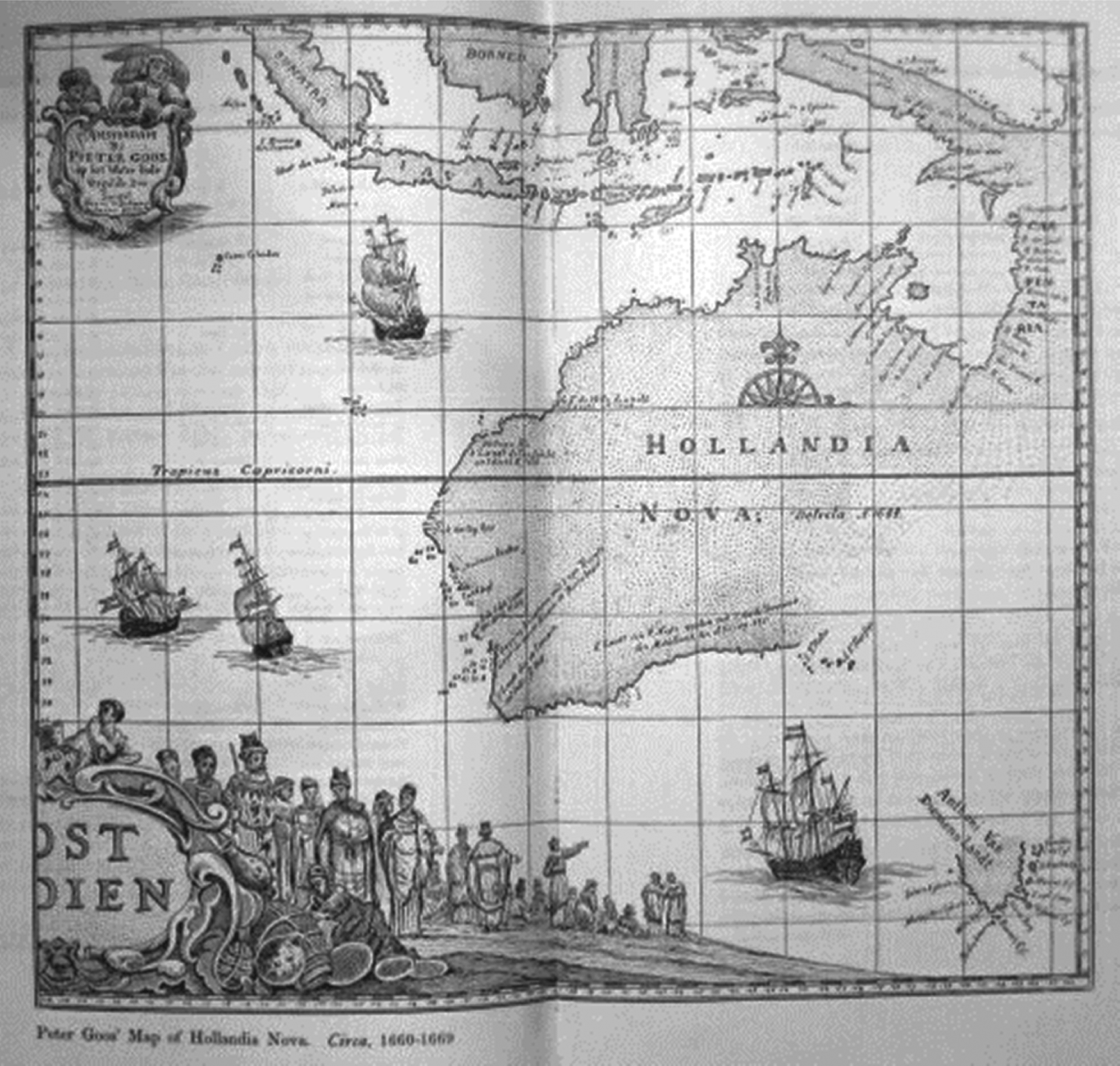
Dampier decided that the Abrolhos (a chain of islands surrounded by shoal water) were wrongly positioned on his chart but that, in itself, is something of a mystery. Frederick de Houtman, commanding the Dutch ships Dordrecht and Amsterdam, found the archipelago in 1619, reporting it, correctly, as ten miles long in latitude 28° 46′S (Heeres, Reference Heeres1899). A sighting and charting by the English Captain John Daniel of the ship London in 1681, also gave the correct latitude of 28° 36′ at the archipelago centre. Possibly, Dampier was using a chart (see Figure 11) by the Dutchman Petr Goos showing a non-existent archipelago in about 27° S as well as the Abrolhos (which he does not name) in their correct position.
Petr Goos' map of Hollandia Nova. Circa 1660 to 1669. Like Bowrey's map in Figure 9 it shows New Guines joined to New Holland.
Whatever the case, Dampier deserves full marks for taking decisive and well-judged action in what was, for him, a critical situation. He is also to be commended for recognising that the trace of seabed recovered from the tallow of his sounding lead at 0100 on 31 July indicated that they were over “coral rocks”. Clearly, he had made good use of his previous experiences of navigating in tropical waters and he would certainly have remembered his recent experience of passing near the other Abrolhos Islands off the coast of Brazil where he had also found a water depth of 25 fathoms over coral.
Once clear of the shoal, and to the north of it, Dampier steered ENE and at 0900, in 40 fathoms of water over clean sand, they saw land from the topmast at about ten leagues distant. It was their first sighting of New Holland. At this point, the Master's Log showed the Roebuck as 140 degrees of longitude from Brazil. (This compares with the real difference of 152° between Bahia/Salvador at 38° W in Brazil and Geraldton at 114° E in Western Australia.) Later, Dampier closed the land and found 54 fathoms of water within four miles of the shore in latitude 26° 10′S.
6. SHARKS BAY
Dampier was anxious to seek a harbour so he could refresh his crew after their three month voyage from Brazil. Accordingly, he headed northwards and stood close in to the shore, sounding and recording the depth of water and noting a great variety of sea-bed samples. In a latitude of 26° S, on 2 August he saw an opening and ran in towards it but, although it was two leagues wide and there was 20 fathoms of water within two miles of the coast, he saw “rocks and foul ground within” and so he turned away. Correctly anticipating westerly gales, and fearing being trapped close to a lee shore, Dampier stood well out to sea and did not pick up land again until the evening of 5 August at 12 leagues from the shore.
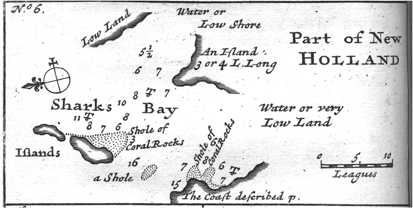
At noon on 6 August the ship was in latitude 25° 30′S with a cape bearing SWxS and distant five leagues. Dampier saw another opening in the land and ran in towards it, eventually anchoring in 7½ fathoms of water over clean sand and two miles from the shore. He named the sound Sharks' Bay and recorded its latitude as about 25° S. The longitude he estimated as 87° from the Cape of Good Hope which, he noted, was “195 leagues less than is usually laid down in our common charts, if our reckoning was right and our glasses did not deceive us.” See Figure 12.
Dampier's chart of Sharks Bay (Note, North is to the left).
In fact, the charts had the better of it. The 195 leagues he quoted was equivalent to about 9° of longitude which implies that the value given on his “common charts” corresponded to a longitude difference of 96° which was remarkably close to the real figure of 95°.
Dampier's under-estimate of his progress eastwards across the South Indian Ocean is consistent with his previously noted under-estimate of his progress across the South Atlantic. The cause is likely to have been similar. Possibly the sand in his nominally half-minute sand glasses ran too quickly but, more likely, in both cases, he was unaware of the strength of the easterly current that helped him on his way across both oceans.
Dampier stayed for a week in and around Sharks Bay, searching for wood which he found and water which he did not find. Disappointed, he sailed out of the bay on 14 August and followed the trend of the coast toward the northeast. He sounded frequently and made careful notes of his findings and of everything else he saw on the way. The general trade wind he reports as SSE, but there was also a strong onshore sea breeze during the day and an offshore land breeze at night. He noted that the tides were increasing as the Roebuck sailed further northwards.
Dampier kept close inshore when he felt it was safe as he tried to find “an opening or other convenience of searching about for water.” At other times, and particularly at night, he kept further offshore to avoid shoals and when he feared becoming caught too close to a lee shore.
7. THE DAMPIER ARCHIPELAGO
On 20 August, Dampier found that he had lost sight of land, partly because of a persistent offshore wind and partly because the trend of the coastline had changed from NNE to NE. On 21 August, the sea breeze set in again and he was able to run in toward the land, which was seen from the masthead at noon. He continued to close in on what he described as a “bluff point” and, at sunset, he anchored in 20 fathoms with a headland bearing SExE at a distance of four leagues. He later discovered the headland to be part of an island. From the entries in the Master's Log it is difficult to establish exactly where he dropped anchor, but it could have been near the “First Anchorage” marked on Figure 13.
Dampier Archipelago. (Possible track of Roebuck in green).
Dampier placed the archipelago in latitude 20°21′S, but he said that Tasman's chart had laid it down in 19°50′S. Also, Dampier saw a chain of islands where Tasman's chart, correctly as it turned out, showed a continuous coastline broken only by rivers.
Dampier conceded that Tasman's estimate of the difference of longitude from Shark's Bay agreed well enough with his own estimate of 232 leagues, but this only makes sense if he really meant 232 miles. 232 leagues, or 696 miles could not possibly have been sailed by Dampier in seven days, as he groped his way around the coast. Crossing the South Indian Ocean, with strong westerly winds behind her, the Roebuck's best day's run was 96 miles, -just four knots. In any case, 232 leagues sailed would have put the Roebuck off the coast of Australia in about 17° S, near where Dampier landed in 1688 as described in Section 2 of this paper. Despite his disagreement with Tasman as to the latitude, it seems certain that Dampier had anchored in what is now known as the Dampier Archipelago, off what became the town of Dampier. However, Tasman's latitude is unlikely to have been as much as 30’ adrift and he might well have been referring to another part of the coast further to the North East.
On 22 August, Dampier took the Roebuck in among the archipelago reaching 20° 32′S by noon. He then continued amongst the shoals as far as he dared and anchored at 1600 in six fathoms. He sent boats ashore but again failed to find fresh water on any of the islands, one of which he named “Rosemary Island”, perhaps the one that still bears that name today. Disappointed, and feeling uncomfortable with his new anchorage due to its exposure to wind and tides, and its proximity to shoal water, Dampier sailed out of the archipelago at 0500 on 23 August to make use of the last of the land breeze. His timing was good, because he reports that, before 0900 the onshore sea breeze blew so strongly that he had to take in his topsails.
He resumed his coasting towards the northeast and, as before, he kept as far inshore as was safe during the day but further offshore at night. He was still urgently looking for a place where he might anchor safely and seek water and, again, his principal navigational aid was the sounding lead.
8. LAGRANGE BAY
On 30 August, in 18° 21′S, Dampier saw “many great smokes near the shore”. He steered towards the land and, in the afternoon, anchored in a “deep bay” in eight fathoms of water over coarse sand and coral about 3½ leagues from the shore. The log book entries strongly suggest that this was Lagrange Bay rather than what is today known as Roebuck Bay (See Figures 2 and 15).
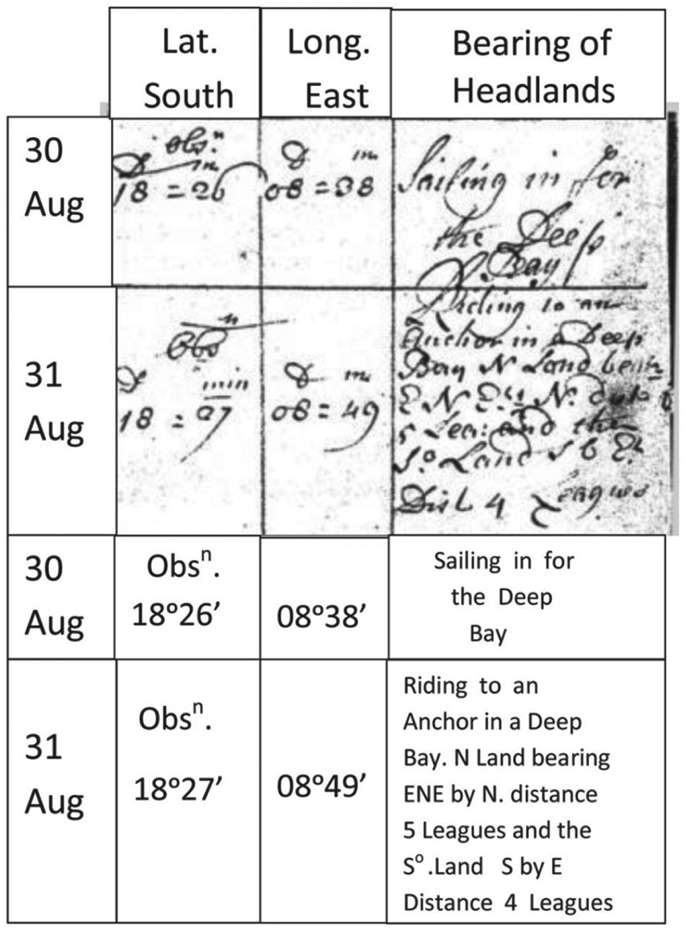
His anchoring position on 31 August was in latitude 18°27′S, with the “North land bearing ENExN distance 5 leagues and the South land bearing SxE distance 4 leagues”. The corresponding entries in the Master's Log are reproduced in Figure 14 for 30 August and 31 August, and the bearings of points of land from the first anchorage are plotted in Figure 15. Note that the logged longitude of 8° 49′ E was reckoned as the difference from the position where the Roebuck first made contact with New Holland, at which point the longitude entry in the Master's Log was reset to 00° 00′.
Entries in the Master's Log for 30 and 31 August 1699
Lagrange Bay and track of the Roebuck.
Dampier was never so rash as to make a guess at his true longitude from Greenwich that, on 31 August, would have been about 122° E. The actual longitude of his first contact on 30 July was 114° E, so the true difference was some 8°. His log entry of 8° 49′ E on 31 August was therefore a remarkably good estimate, considering the frequent alterations of course he had made and the currents and tidal streams through which he had passed during the preceding month. At Lagrange Bay, he reset his longitude again to 00°00′.
Dampier was much impressed by the strength of the local tidal streams off Lagrange Bay, as well he might have been, for the huge tidal range in the vicinity of Broome is nearly ten metres at springs. In his own words, “I observed the flowing of the tide, which runs very swift here, so that our nun-buoy would not bear above the water to be seen. It flows here (as on that part of New Holland I described formerly) about 5 fathom: and here the flood runs south-east by south till the last quarter; then it sets right in towards the shore (which lies here south-south-west and north-north-east) and the ebb runs north-west by north. When the tides slackened we fished with hook and line, as we had already done in several places on this coast; on which in this voyage hitherto we had found but little tides: but by the height and strength and course of them hereabouts it should seem that if there be such a passage or strait going through eastward to the great South Sea, as I said one might suspect, one would expect to find the mouth of it somewhere between this place and Rosemary Island, which was the part of New Holland I came last from.”
Had Dampier but known it, such a strait had already been discovered, albeit much further to the northeast, by Luis Baez de Torres in 1606. Unfortunately his report of the discovery of what became known as the Torres Strait was filed in the Spanish archives in Manila, and forgotten. It was nearly 200 years before it again saw the light of day (Hilder, Reference Hilder1977).
On 31 August, Dampier took an armed party ashore and had a skirmish with a group of natives but made no further contact with them. By 2 September, his party had found some brackish water but he commented, “this water was not fit to drink. However we all concluded that it would serve to boil our oatmeal, for burgoo, whereby we might save the remains of our other water for drinking, till we should get more”.
On 3 September, Dampier took the Roebuck closer inshore (see the second anchor position in Figure 15) and continued his search for water but with no greater success. At this stage, by his own account, he felt that he had been following “a shore I was already almost weary of”. In fact, with the welfare of his crew in mind, he, perhaps, had little choice as he explained. “Thus, having ranged about a considerable time upon this coast without finding any good fresh water or any convenient place to clean the ship, as I had hoped for and it being moreover the height of the dry season, and my men growing scorbutic for want of refreshment, so I had little encouragement to search further, I resolved to leave this coast and accordingly at the beginning of September (the 5th in fact), set sail for Timor.”
What Dampier does not explain, and what remains something of a mystery, is why he did not make for the place where, in 1688, on the Cygnet, they had found both water and a convenient place to clean the ship. He could not have established that he was near the same longitude but, from his latitude observations and his knowledge of the trend of the coastline, he must have suspected that the place of his former visit was much closer than Timor.
Beyond the scope of this paper, Dampier continued with the Roebuck to Timor and thence, via the north coast of New Guinea to discover an archipelago that he named New Britain. He had intended to return to New Holland to seek the strait which he suspected would lead him towards the east coast of New Holland and thence make his return voyage along the east and south coasts, thus fulfilling the main purpose of his voyage.
Unfortunately, by the time Dampier returned to Timor, he found himself in command of a slowly sinking ship that was in no condition to undertake further explorations of New Holland. Accordingly, he set out for Batavia and then for home via the Cape of Good Hope. He didn't make it. The Roebuck's rotting timbers finally fell apart and she sank in the South Atlantic off Ascension Island, where Dampier and his crew had to wait for a month before hitching a ride back to England.
7. CONCLUSION
During the 17th and 18th Centuries there was intense competition, particularly for the spice trade, between the English East India Company and the long-established Dutch East India Company. Joan van Hoorn, the Governor General of the Dutch East Indies in Batavia, paid unintentional tribute to Dampier's achievements when, in 1705, he sent three ships to explore the north coast of New Holland, one of his aims being “to prevent the voyages of William Dampier from entailing unpleasant consequences for the Dutch East India Company.” (Heeres, Reference Heeres1899).
William Dampier was a failed pirate and no great shakes as a leader of men. He was, however, by any assessment, a remarkable navigator. In addition to his voyage as Commander of the Roebuck, he was largely responsible for the navigation of the ships involved in his three circumnavigations of the world, and in less extensive voyages in between. He was clearly an adventurous explorer, but he would not have survived had he been foolhardy. He was numerate at a time when many of his colleagues were not. Above all, he made intelligent use of the crude instruments that were available to him, while being well aware of their limitations. For the author, he was one of the all-time great navigators.
APPENDIX 1699 – A FLAVOUR OF THE TIMES
• William III was King of England
• Peter the Great was Tsar of Russia
• Louis XIV (The Sun King) was King of France
• China was ruled by the Kangxi Emperor, the 4th in the Qing dynasty
• Tokugawa Tsumayoshi was Shogun of Japan
• Sir Isaac Newton was Lucasian Professor of Mathematics at Cambridge University.
• Sir Christopher Wren was building the new St Paul's Cathedral on the ashes of the old one, burnt down in the Great Fire of London in 1666.
• Edmund Halley was conducting the first magnetic survey of the Atlantic Ocean.
• Both Johann Sebastian Bach and George Frideric Handel were aged 14, and Antonio Vivaldi at 21 was a priest. All three were on the verge of illustrious musical careers.
• Antonio Stradivarius was busy constructing incomparable violins and other stringed instruments in Cremona, but the piano had yet to be invented.
• Old Widow Coneman was executed in the name of God for witchcraft at Coggeshall, England, just six years after the notorious Salem witch trials in New England.