This report identifies and describes patolli petroglyphs at the archaeological sites Plan Grande on the island of Guanaja and at Sawacito in the department of Olancho in northeast Honduras (Figure 1). Illustrations in earlier reports on Plan Grande (ELAP 2006; Feachem Reference Feachem1940) attracted my attention, because they very closely resembled patolli petroglyphs but were not identified as such. Another patolli petroglyph was recognized in photos from Sawacito that were shown to the author. During a visit to Plan Grande in 2018, I aimed to relocate the previously published petroglyphs. Additionally, we documented three new patolli petroglyphs at the site. In the following report, I describe the petroglyphs at Plan Grande and Sawacito, including their respective archaeological contexts.
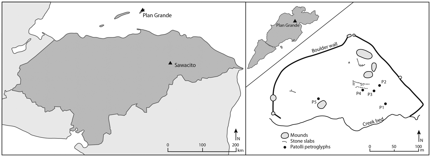
Left, location of Plan Grande and Sawacito in Honduras; right, sketch of Plan Grande based on Strong (Reference Strong1935:Figure 35), with the approximate location of the petroglyphs.

The Patolli Game
The patolli game has been the subject of various publications (e.g., Caso Reference Caso1925; Mountjoy and Smith Reference Mountjoy, Smith, Folan and Riley1985; Smith Reference Smith and Hammond1977; Swezey and Bittman Reference Swezey and Bittman1983; Voorhies Reference Voorhies2013; Walden and Voorhies Reference Walden, Voorhies and Voorhies2017). Most of the information about it originates from ethnohistorical sources about Aztec society (Durán Reference Durán, Horcasitas and Heyden1971 [1574–1579]:302f; Sahagún Reference Sahagún1938:298, 320). They explain that the popular game was often played during feasts and that it was tied to religious practice and cosmovision. Beans (patol) were used as dice, and tokens were set on a scoreboard that consisted of a cross or x-shaped pattern subdivided into quadrangular fields, sometimes accompanied by an additional frame of fields.
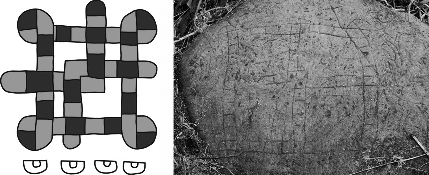
Game boards that closely resemble those described in ethnohistorical sources and depicted in codices have been found in archaeological contexts and are believed to be the precursors of the colonial-period game (Figure 2). Although Barbara Voorhies (Reference Voorhies2013) shows that the roots of the game might be much older, the first known game boards date to the Early Classic period (AD 300–600) and appear in central Mexico and the Maya Lowlands. In later periods, they are also present in West Mexico and the Gulf Coast (111f). Most of the archaeological patolli boards are found engraved into flat stone slabs or scratched into plaster floors, whereas among the Aztec it was common to paint the board on mats (Durán Reference Durán, Horcasitas and Heyden1971).
Patolli boards: left, as illustrated on p. 62 of the Codex Borgia (drawing by F. Fecher); right, petroglyph documented near Sawacito (photograph courtesy of C. Woda).

Swezey and Bittman (Reference Swezey and Bittman1983:405, 413) state that, based on its temporal depth and geographical distribution, the patolli game was an integral part of Mesoamerican culture. To the best of my knowledge, there is no documentation of the game in an archaeological context outside the traditional frontiers of Mesoamerica.
Patolli Petroglyphs at Plan Grande, Guanaja
The Plan Grande Site, Guanaja
Plan Grande lies on Guanaja, the easternmost of the Honduran Bay Islands. The site is located on the northeastern section of the island and consists of at least 10 flat earthen mounds that stretch out on a flat terrain (Figure 1). The mounds are associated with monolithic stone slabs and formations of upright standing stones. The northern part of the site is enclosed by a low boulder wall, and the southern area is delimited by a narrow stream. Based on pottery fragments excavated at the site by William D. Strong (Reference Strong1935), Plan Grande can roughly be dated to the Selin (AD 300–1000) and Cocal (AD 1000–1525) periods.
Although Plan Grande has never been excavated intensively, it was the site of several brief investigations. It was first mentioned in the mid-nineteenth century (Young Reference Young1842:48). In the 1930s, it was visited by F. A. Mitchell-Hedges and the Boekelman Shell-Heap expedition. Both teams conducted surveys, excavated test pits and collected objects. The most detailed account, however, is given by Strong (Reference Strong1935); because the previous expeditions did not yield scientific publications, their results were partly summarized by him. He created a site map and concluded that Plan Grande must have been of a ceremonial character based on the lack of abundant potsherds and refuse heaps and the nature of the stone alignments. The first to explicitly mention and illustrate a stone with a patolli design at Plan Grande, although it was not recognized as such at the time, was R. W. Feachem (Reference Feachem1940).
After this rather concentrated interest, the island seems to have fallen into oblivion. Short visits were paid among others by Alan Craig (Reference Craig1977) and the Honduran Institute of Anthropology and History (IHAH; Cruz Castillo Reference Cruz Castillo1999). The last major project commissioned by the IHAH was to design an archaeological park in the surroundings of the site (ELAP 2006). During the project, nine monolithic stone slabs were mapped, including the one previously illustrated by Feachem, but the engravings seem not to have been noticed. Instead, the surveyors emphasized another stone with a similar design. Once again, the design was not identified as a patolli game board.
New Investigations at Plan Grande
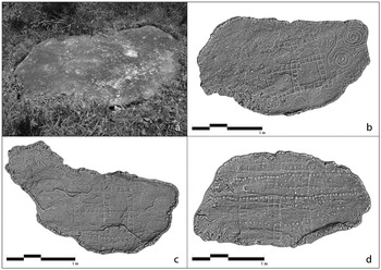
During a visit to Plan Grande in 2018, we were able to find the two stones reported by Feachem and the ELAP. Three other slabs showed vague engravings, and we documented all five stones with photographs from which 3D models were created by Michael Lyons. The original models were generated using Agisoft Photoscan software. Rendering the images with a radiance scaling shader in MeshLab made visible that which was not visible to the naked eye: each stone is engraved with a patolli petroglyph (Figure 3).
Patolli petroglyphs at Guanaja: (a) photograph of petroglyph 3, on which vague engravings can be seen; (b) 3D model of petroglyph 3, on which the patolli design becomes visible; (c) 3D model of petroglyph 4; (d) 3D model of petroglyph 5 (3D models courtesy of M. Lyons).

All of the five patolli boards at Plan Grande are located on heavy, flat stone slabs and are engraved in low relief. The engravings are about 1 m wide and show a similar design: a cross subdivided into quadrangular fields framed by a square also subdivided into fields. The corners of the frame are twisted and formed by four fields, respectively. Each petroglyph shows little variation.
Petroglyph 1
Petroglyph 1 is the petroglyph documented by Feachem (Reference Feachem1940). His illustration shows that at two points, the arms of the cross extend beyond the frame and form additional fields. Swezey and Bittman (Reference Swezey and Bittman1983:383) note that such fields might have served as entries or exits to the game. The petroglyph includes 72 fields. It is associated with small, round cavities aligned with respect to one another, which might have served as another kind of game.
Petroglyph 2
Petroglyph 2 is the petroglyph documented by the ELAP (2006). The slab that bears the petroglyph is broken, which is why only part of the petroglyph is visible; sediment covers a large part of the slab. The petroglyph consists of a framed cross. Its center is formed by four fields. Presumably, it consists of 72 fields. It is associated with spirals and round and oval cavities of different sizes.
Petroglyph 3
The lower half of petroglyph 3 is especially visible. Assuming that its design is symmetrical, it most likely consists of a cross with four fields at its center, as well as an additional field where each arm of the cross meets the frame. Hence, it is composed of 76 fields. It is associated with spirals and individual small cavities.
Petroglyph 4
Some parts of petroglyph 4 are not well preserved, but in its center we can recognize four fields. I assume that there are at least two additional fields where the arms of the cross meet the frame. Thus, the petroglyph is composed of either 74 or 76 fields. It is also associated with parallel lines of small cavities.
Petroglyph 5
Petroglyph 5 is in a poor state of conservation, which is why I can only speculate as to its design. Most likely, it has four fields at its center. If there are any extending fields, they are not clearly visible. The petroglyph is associated with small cavities that run in parallel lines over the patolli petroglyph.
Given that not all of the stone slabs at Plan Grande were recorded photogrammetrically, it is likely that more stones with patolli design exist at the site and its vicinity.Footnote 1
Patolli Petroglyph at Sawacito
Sawacito is located in the buffer zone of the Rio Plátano Biosphere Reserve on the Honduran mainland (see Figure 1). The area adjoins the so-called Mosquitia and is part of the largest coherent zone of tropical rainforest in Central America. As of yet, the region has been poorly studied archaeologically, not least because of its limited infrastructure and inaccessibility. The few investigators who have ventured into the region include Herbert Spinden (Reference Spinden1925), William D. Strong (Reference Strong and True1934), Christopher Begley (Reference Begley1999), and archaeologists of the IHAH (e.g., Lara Pinto and Hasemann Reference Lara Pinto, Hasemann and Murphy1991). In the last few years, the region has attracted attention because of the identification of sizable prehispanic settlements through lidar flights (Fisher et al. Reference Fisher, Fernández-Diaz, Cohen, Cruz, Gonzáles, Leisz, Pezzutti, Shrestha and Carter2016).
The flat stone slab with a patolli petroglyph (Figure 2) was discovered by Christine Woda during fieldwork carried out by the German Corporation for International Cooperation (GIZ) to promote sustainable management of the Rio Platano preserve. Sawacito consists of several earthen mounds clearly visible on the surface and has not yet been investigated. The petroglyph is carved in low relief and measures about 1 m in width. It consists of a cross with a frame, and the corners are each formed by four fields. In contrast to the Guanaja petroglyphs, the corners are rounded. The center of the cross is formed by four squares, so that the petroglyph consists of 72 fields in total. The petroglyph shows additional incisions and scratches, but judging from their lower depth, it is most likely that they do not belong to the original petroglyph. The patolli petroglyph is associated with zoomorphic petroglyphs.
Discussion and Conclusion
These petrographs show that patolli boards not only existed in Mesoamerica, but also that the game was played beyond the traditional frontiers of this cultural region. Northeast Honduras is seen as part of the Isthmo-Colombian Area, although studies carried out there make it clear that it had its own distinctive cultural characteristics (Healy Reference Healy, Lange and Hammond1984; Reindel et al. Reference Reindel, Fux and Fecher2018). The distribution of the patolli boards broadens the evidence that long-distance interaction was taking place between the inhabitants of the regions (e.g., Begley Reference Begley1999). As to its regional and temporal definition, there are only vague hints available to better define this interaction. Stylistically, the petroglyphs mostly resemble Type I of Swezey and Bittman's typology (1983). This type is known from central Mexico and is depicted in codices, which indicates some kind of connection between that region and the inhabitants of Plan Grande and Sawacito during the Postclassic period. However, more data, especially regarding the sites where the patolli petroglyphs were found, are needed to corroborate such a hypothesis.
What the existence of patolli petroglyphs in Northeast Honduras does suggest is that the interaction was not only limited to economic interests but also included the exchange of ideas. Although the extent to which worldviews or religious practices associated with the game were transported remains unclear at this point, we need to keep in mind that, in Mesoamerica, the boards were often found in the context of ceremonial structures and the game was deeply tied to religious practice. This makes it very probable that playing patolli was more than a leisure activity for the inhabitants of Plan Grande and Sawacito. The existence of at least five patolli petroglyphs at Plan Grande indicates that the site was an important center: it likely was a meeting place where gatherings were held accompanied by gaming activities and feasts. Certainly, the game played an important role among the prehispanic inhabitants of Guanaja.
Acknowledgments
This article presents some of the findings of the Proyecto Arqueológico Guadalupe, which receives grant funding from the Swiss-Liechtenstein Foundation for Archaeological Research Abroad, the German Archaeological Institute, and the University of Zurich. I am especially grateful to Prof. Dr. Markus Reindel, Prof. Dr. Philippe Della Casa and the Honduran Institute of Anthropology and History. I would like to thank Michael Lyons for making the 3D models, the PAG-team for all its support, Hans Weller and Edgardo Ortega for their assistance, Dr. Christine Woda for permission to use her illustration, and the three anonymous reviewers for their helpful comments.
Data Availability Statement
3D models are stored in the digital archives of the German Archaeological Institute.