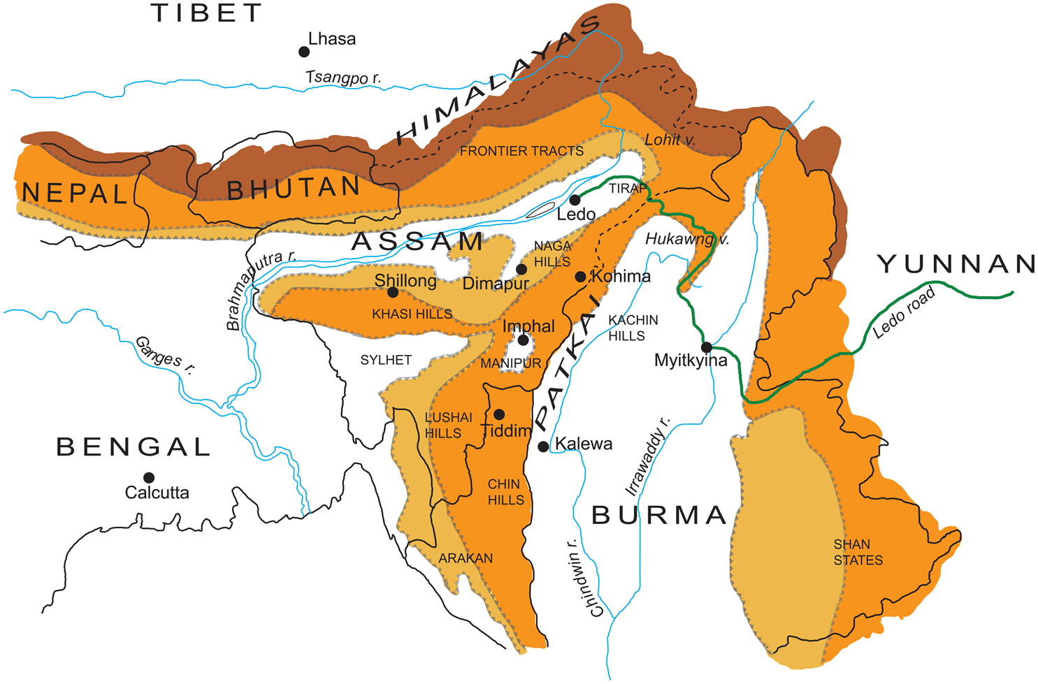



Partition is the most potent sign that for the Indian subcontinent, the end of colonial rule entailed multiple processes of administrative and territorial reshuffling. Yet it was not just India and Pakistan that struggled to distance themselves from one another after 1947–48. Independence also meant renegotiating the terms on which Delhi and Rangoon had dealt with one another. For much of its existence as a British possession, Burma had been a province of the Raj. As this article will show, its entanglement with India's “sub-empire” (Darwin Reference Darwin2009, 9) continued long after their official separation in 1937—not least in the Patkai, the mountainous region between India and Burma (see figure 1).
The Patkai. Map by Bérénice Guyot-Réchard and Tina Bone. Colored areas represent mountainous and hilly regions. The darker the color, the higher the altitude.

Today, India and Burma appear as distinct, bounded spaces anchored in separate regions, South and Southeast Asia. Most Burma-focused scholarship considers 1937 a natural step toward full independence in 1948. For some, Burma had suffered from “double colonization, at the hands of both the British and also India.” Indian historiography has even less to say on the subject (Saha Reference Saha2016, 25). As a result, little work has been done on 1937—whether on India and Burma's anterior association, on the political genesis of separation, or on what it entailed. The stroke of midnight on March 31, 1937, is an accepted watershed, ushering in a new period in Burmese history. We know about how separation was demanded and obtained, but little about what it meant. Current territorial frameworks give Burma and India's pre-1937 relationship the look of an anomaly, of a colonial artifact necessarily meant to collapse.
This ignores signs that the two polities remained deeply entangled in the 1940s and early 1950s. Administratively, Burma was now “an independent entity under the crown, but a very curious one … neither part of the Indian Empire nor a crown colony” (C. Bayly and Harper Reference Bayly and Harper2005, 30–33). The new Burma Office had no dedicated post within the British Cabinet; India's Secretary of State doubled as Burma's. The Survey of India remained in charge of mapping the new colony, and the Indian rupee remained in use (IOR 1945a; NAI 1954a, 1954b, 1955). Nor did socioeconomic ties disappear. Indian immigration continued beyond 1937, along with the rice exports that made Burma an essential agricultural partner for India. Rather than taking the 1937 separation for granted, one should explore how India and Burma sought to assert their bounded, distinct character, and with what consequences.
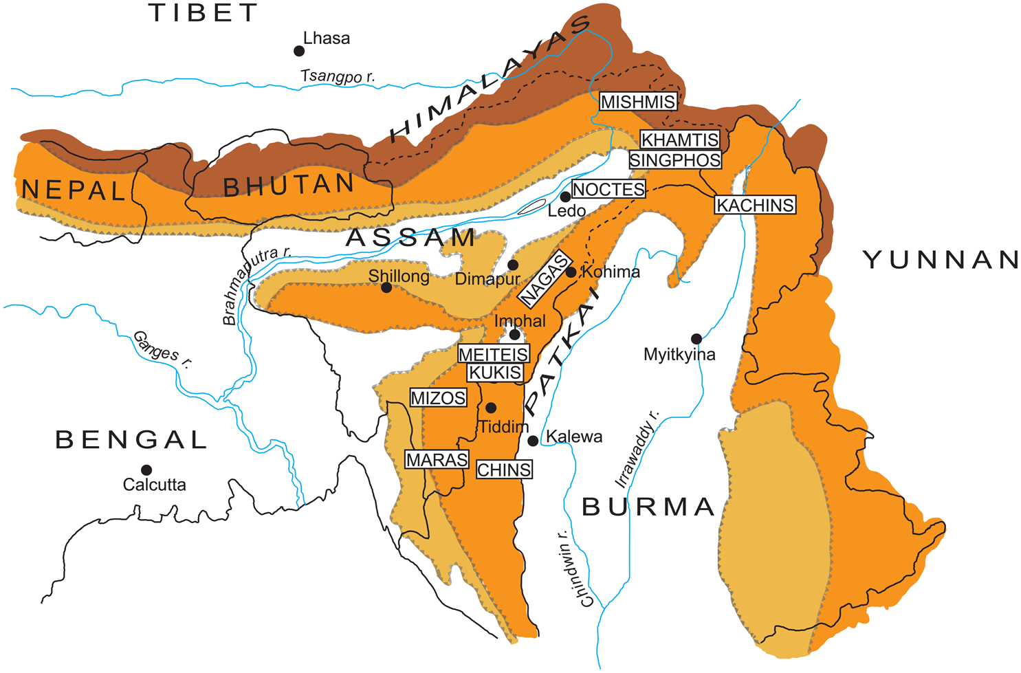
This struggle to define themselves against each other took on specific salience in the Patkai. The Patkai's Naga, Zo, and Kachin inhabitants (reductively called “tribes” in India and “minorities” in Burma) were of so-called Mongoloid stock, like many people in the Indian province of Assam. Dense networks of interaction and exchange shaped their lives across the Irrawaddy and Brahmaputra basins and the wider region (see figure 2). The Patkai's diverse human landscape cohered around shared ethnic, cultural, and socioeconomic traits, practices, and ties: the prevalence of shifting agriculture and oral cultures, for instance, or of comparatively egalitarian sociopolitical orders. Fluid and fragmented, local identities did not entail a subjective sense of belonging at the level of the Patkai itself. Many were rooted in an ambivalent, dialectical relationship to nearby states whose centers lay in the plains. These qualities can justify treating the Patkai as part of a wider trans-Asian mountainous region, falling off the map because it does not fit current-day geopolitical imaginaries: Zomia (Scott Reference Scott2009; van Schendel Reference van Schendel2002). India and Burma's purported divide thus ran against the grain of a fluid, connected, and dynamic human landscape (Cederlöf Reference Cederlöf2009).
The people of the Patkai. Map by Bérénice Guyot-Réchard and Tina Bone. Colored areas represent mountainous and hilly regions. The darker the color, the higher the altitude.

That the Patkai had only recently been divided between India and Burma heightened the border's immateriality. Neither of them, in this context, were stable state formations. The Patkai was a “zone of interpenetration” (Elliott Reference Elliott2014, 341) and tension where Burma and India's poorly defined claims to political authority dissolved, uncomfortably, into one another, even as local life-worlds pushed back at them. Delineating Burma from India was thus anything but self-evident. Drawing on British, Indian, and Burmese archives and private papers, this article explores the fraught, problematic efforts of government officials to square off competing imperial, national, and borderlands logics in order to shape a workable political and social map of the Patkai after 1937—efforts that ultimately proved self-defeating.
Viewed from the borderlands rather than the center, Burma and India's separation was thus a complex, nonlinear process with only a murky sense of finality—and this, until the eve of independence. For the Patkai's inhabitants, in hindsight it resembled a partition, one among several meant to create new bounded spaces in and around the Indian subcontinent over the course of the twentieth century. In place of an amiable divorce between two ill-suited partners, 1937 appears as an unfinished and pain-ridden separation, its meanings far more problematic and contested than generally acknowledged. This article therefore recovers connections and interactions that illuminate the making of the Burmese and Indian polities in the contemporary era as a relational process. Yet it also points to the ways in which governmental efforts to do away with what they consider their unpalatable entanglement is also constitutive of the violence of late colonial and postcolonial borderlands like the Patkai.
Bleeding Boundaries
On April 1, 1937, Burma formally split from India. Archibald Cochrane became its first governor and a Council of Ministers took office, ending a century of association. Burma's status as part of British India had been anathema to Burman nationalists. Campaigns to separate it from the Raj had intensified since World War I, fueled by limited power devolution in India. When constitutional reforms came on the agenda, colonial authorities eventually agreed to the demand. Two years after the Government of Burma Act, 1935, Burma became a stand-alone colony, with Rangoon as its capital. “Burma divorces India,” ran the headlines (Christian Reference Christian1937).
Advocates of separation saw incommensurable differences between Burma and India. For them, Burma was a Buddhist, Burman, and Irrawaddy-centered land.Footnote 1 “The Burmese live in a country … quite distinct from India,” asserted the Simon Commission, dispatched in 1930 to discuss constitutional reform. Thousands of miles separated Rangoon from Indian metropoles, and locals were “entirely different from the peoples of India” (ISC [1929] 1988, 77–78). Nor had India's kings ever ruled Burma; the union was an accident of colonial rule. It seemed “a universal opinion … that Burma should never have been placed under the Government of India” (Christian Reference Christian1937, 82).
Yet, where Burma ended and India began was anything but clear in 1937. Pro-separation arguments evoked “a practically impassable barrier” of “sea, mountain and jungle” between the two colonies (ISC [1929] 1988, 77–78). The reality was that the demarcation had been a source of debate for much of the colonial period (Saha Reference Saha2016, 23). Burma was a puzzle to early British administrators and visitors. Did it belong to India or was it “a discrete cultural entity”? How much did Burman culture owe to India (Jarvis Reference Jarvis2011, 796)? To French orientalists and some South Asian nationalists, Burma belonged to a “Greater Indian” civilization, shaped by Hinduism; Sanskrit; Buddhism; and their literary, artistic, and architectural monuments (S. Bayly Reference Bayly2004). Viewed from an oceanic rather than a national lens, static notions of India versus Burma receded in favor of a different, transnational geographic space—the Bay of Bengal (Amrith Reference Amrith2013).
Interpretations emphasizing a cultural grammar that had traveled by sea from the subcontinent were just as flawed as visions of Burma as India's radical Other, however. Both notions naturalized powerful spatial, ethnic, and economic hierarchies shaping that part of the world during British rule. Under these hierarchies, the lands between Mandalay and Calcutta—the Patkai especially—existed only as the most irrelevant of peripheries, a no-man's-land that merely functioned as a wall. Treating the separation as self-evident or as a fait accompli erased the Patkai's existence and its inhabitants’ needs and experiences, while silencing the violent and unfinished historical processes that had apportioned it between India and Burma under colonial rule.
British expansion in the Patkai had been late and protracted. In 1826, the East India Company forced the Burmese kingdom of Ava to relinquish Assam and Manipur, taking over regions that Mughal rule had never encompassed. Ava itself was conquered in 1885. Much of the Patkai was annexed piecemeal over the next few decades, often after military campaigns against “raids” on the lowlands. Light administration was subsequently extended. Some areas went to Burma, others to Assam and Bengal, largely based on the expedition's departure point. Burmese and Indian “sides” thus coalesced in the Zo-inhabited highlands after the 1889–90 Chin-Lushai Campaign, when Assam, Bengal, and Burma installed separate outposts in subdued areas. Indian proposals to bring all Zos (Chins, Lushais, etc.) under a single administration fell through, with Rangoon arguing that administrative convenience called for its retention of the Chin Hills (Pau Reference Pau2007). Military expeditions, surveys and ethnographies, land and resource expropriation, missionary endeavors, and restrictions on hill-plain interaction ensued (e.g., Franke Reference Franke2009; Kar Reference Kar and Baruah2009; Misra Reference Misra1998; Pachuau and van Schendel Reference Pachuau and van Schendel2015). In the process, they helped frame India and Burma's geo-body in ways that left the Patkai a disaggregated territorial patchwork (Zou and Kumar Reference Zou and Satish Kumar2011) and fostered ethnicization (e.g., Pachuau Reference Pachuau2014).
Though disruptive, colonialism could not entirely fossilize an India-Burma divide in the Patkai, if only because of its own territorial and capitalist compulsions. The colonial state's presence was uneven and often indirect. On the eve of separation, the Raj's internal demarcations remained fuzzy. In Zo areas, the boundary between Burma's Chin Hills and Assam's Lushai Hills District was neither manned nor demarcated. Provincial government outposts notwithstanding, cross-border ties—marriage, trade, visits, and disputes—continued. Some Zos developed links to authorities “on the other side”: Mizos (Lushais) thus enlisted in Burma's Chin Battalion (NAI 1949). To the north, sizeable Naga-inhabited regions continued to elude Assam's writ. Burma's administration of Naga areas was even thinner. The local boundary had not been delimited, and knowledge of the border zone was scant. More uncontrolled areas—inhabited by Shans, Kachins, and Nagas—lay further north (Sadan Reference Sadan2013, 48–49).
India and Burma hence reached formal separation in a situation where their presence in their common borderland was still unconsolidated. Intricate cross-border webs of relations—trade, migration, family ties, migration, alliances, and enmities—undercut British attempts to territorialize the region into a series of bounded spaces, whether between Assam and Burma or between administered and uncontrolled zones. For the Patkai's inhabitants the divide was an imposition, but the constraints it created could not quite contain them. At times, it could be a resource. Zos went forum-shopping during marriage disputes, for instance (MNA 1937b). The notional border could even spare people from some of the effects of colonialism, as an incident between cross-border, unadministered Naga villages reveals.
In 1940, the village of Kawn raided a settlement on the Burma side, apparently for assisting colonial troops against an allied village. Burma officials seeking to punish Kawn were in a quandary: they did not know where it was. Worse, the village likely lay across the watershed, presumably on the Assamese side. It would not do “if trans-frontier villages … [raided] Burma on behalf of Burma villages.” Burma officials thought themselves best located to undertake the punitive expedition, given Kawn's distance from Assam's administered zone. Assam rejected the proposal, fearful to have its future authority undercut. Burma could justifiably venture beyond the watershed in hot pursuit or issue warnings against crossing it, but it had no right to punish a trans-Patkai village (IOR 1937).
The incident's administrative afterlife revealed the colonial state's limitations in Naga areas. The difficulty of identifying and reaching Kawn, the tussle over how to respond, and the lack of action testified to the colonial state's unconsolidated posture in Naga areas and the difficulty of arriving at a “state friendly” boundary. The creation of distinct Burmese and Indian spaces was easier said than done. Indeed, at times they bled into one another. Delineating distinct geo-bodies in the Patkai would remain an elusive endeavor until the very eve of independence.
India and Burma's official separation made the entanglement more unpalatable. Now that the Raj's internal demarcation had become a border within the British Empire, the consolidation of state presence in the Patkai was urgent. International measures against slavery and opium were now binding, so campaigns against slavery and human sacrifice increased alongside attempts to insulate administered areas from “controlled” and unadministered ones (Das Reference Das2014; Maule Reference Maule2002). Yet enforcing them and concretizing the separation entailed a control and a knowledge of the highlands that neither Assam nor Burma possessed.
To protect themselves from criticism and free their hand, colonial administrators legally excised the Patkai from Burma and India's normal administration. It became an “Excluded” or “Tribal Area” (IOR 1945b; Verrier Elwin Papers 1942).Footnote 2 The Naga Club, an indigenous organization mainly composed of Naga interpreters and chiefs (and hence linked to colonial administrators) had requested precisely such a retrenchment for the Naga Hills (Naga Club [1929] 2013). Colonial authorities simultaneously decided to stop treating unadministered areas as buffer zones, neither within nor without the Empire. From now on, the Patkai should belong to either India or Burma (IOR 1937).
In 1940, Assam and Burma accordingly decided to expand administration over the entire Naga area. This meant delimiting a border between India and Burma. Taking responsibility for a given area depended on an agreed boundary line that, in some regions, did not exist. To Assam officials’ dislike, Rangoon unilaterally created a Naga Hills District and announced expansion plans. Hitherto more expansionist, Assam balked at “the extension of administration into … the ‘no man's land’ … at such great pace.” Could they first devise a boundary? Burma officials refused. Such a delimitation would work to their government's detriment: their presence in the Naga Hills was far more superficial than Assam's (NAI 1945a). Even after 1937, Burma's involvement in the region had been minimized. This disinterest could now cost the colony territory—especially since officials feared Assam wanted to incorporate all Naga regions. It made sense to postpone a boundary settlement until Burmese colonial authorities’ claim to administer their side of the Naga areas held water, and to stick to the watershed as the boundary (MNA 1937a, 1957).Footnote 3 Serendipitously for Rangoon, war had broken out in Europe. Burma halted expansion but insisted that the intra-imperial boundary issue be set aside. Now was not the time to settle such a small matter (IOR 1937).
In the immediate aftermath of 1937, the Burmese and the Indian states’ twin compulsions to define authority and put spatial limits to it (Ray Reference Ray2019) had thus worked against each other. The contradiction would remain throughout the late colonial period. For now, the Second World War had put on hold Assam and Burma frontier officials’ respective plans to pull away. Yet in the end, the conflict would only intensify India and Burma's entanglement.
Bound by War
In early 1942, World War II came to the Patkai. After conquering much of the Indochinese Peninsula and the Dutch East Indies, Japanese forces stalled in its foothills. Almost overnight, the region became a military front line. Wartime societal and administrative upheavals would only deepen India and Burma's entanglement. Some colonial officials would emerge from the conflict convinced that the Patkai's map should be redrawn and India and Burma's unfinished separation rethought—and of their special responsibility in doing so.
War proved a tremendous agent of change. While troops poured in, huge infrastructure projects meant to propel the war effort (e.g., airfields, railways, arsenals, and hospitals) redefined the landscape. Only a handful of modern routes, mostly mule or porter tracks, had connected the Irrawaddy and Brahmaputra basins before 1942 (Guyot-Réchard Reference Guyot-Réchard2018). Now, jeepable arteries (like the Stilwell Road from Assam to Yunnan) crossed the Patkai. Roads became the focal points of trade and interaction across the Southeast Asian Massif and the eastern Himalayas—formal and informal networks that preceded the war but were fueled by it. Opium circulation expanded (NAI 1946a). So did that of guns and ammunition, fueled by the concentration of troops and the arming of Patkai communities (APSA 1945a; IOR 1947a, 2–4; NAI 1946b).
War thus gave a tremendous fillip to the colonial state's penetration in the highlands. Yet, far from crystallizing distinct Burmese and Indian national spaces, the conflict had transnationalizing effects. The wartime administration's trials compounded the phenomenon. The Japanese invasion had played havoc with administration in Burma's highlands. The governor had fled to northern India and, with Burman areas held by a nationalist Thakin government under Japan's thumb, the last remnant of colonial government was the small Frontier Administration, trying to mount resistance against the Japanese. It needed a lifeline, and that lifeline came from Assam.
The India-Burma divide further eroded, physically and administratively. In some cases, the unfinished separation gave way to reintegration. For much of the war, British Indian frontier officials provided their Burma counterparts with their main link to the outside world—their primary line of communication and supplier of food, weapons, and supplies (MNA 1944a; Stevenson, Reference Stevensonn.d., 282–325). The Chin Hills superintendent stopped heeding his government-in-exile's orders, liaising with his Lushai Hills counterpart instead. Resenting his superiors’ attempts to supervise him from their faraway refuge, he took decisions of his own accord. Eventually he defended reattaching Burma's Chin Hills District to Assam (likely on the latter's suggestion). In his reasoning, Burma “[had] no standing in India and [was only]… another obstacle to go over” (McCall Reference McCall1942).
Where Burma's colonial administration had collapsed, such a reattachment de facto took place. In the Arakan highlands, Assam officials mobilized the inhabitants and preserved a facade of administrative normalcy. They mobilized for civilian defense and assumed the duties of local district officers—trying robbery cases, releasing prisoners, or discussing house tax and village boundaries (Bowman Reference Bowman1984, 98, 106). In the northern Patkai, Assam officers toured Burma's unadministered Naga hills while locals crossed into India to have their disputes heard (APSA 1943).
The conflict fueled clamors for territorial reorganization among sections of the inhabitants. Political activism was increasing in the Assam highlands, notably among a growing, educated middle class. The ethnicization of identity and belonging intensified and reached non-elite groups, while people increased the demands they made on the colonial state. By 1945, many were campaigning for jurisdictional and territorial change. Many Kukis had actively fought to evict colonial presence in their midst (Guite Reference Guite2010). From Manipur, a group of Nagas and Kukis petitioned for a single administration across the Patkai and eastern Himalayas and for constitutional protections, stressing that they shared little culturally or historically with India and had only become part of it under the Raj. To the south, twenty-five Mara chiefs wrote to complain about their division between Assam's Lushai Hills and Burma's Chin Hills and Arakan districts, requesting their own district (APSA 1945b). The inhabitants thus actively contested the spatial configurations of colonial rule in the Patkai.
If war fused India and Burma together, it also accelerated changes in official attitudes toward the Patkai's inhabitants, long branded “as potential enemies and criminals” (IOR 1944). A romance of the frontier already existed, but colonial perceptions that the Nagas or the Mizos had joined the war effort out of loyalty to the Empire led to their characterization as heroic, authentic beings whose sacrifice should be rewarded (IOR 1944; MNA 1945a; Stevenson, Reference Stevensonn.d., 270–71). “Primitiveness” became a marker of cultural purity and a source of admiration (Pawsey Reference Pawsey1947). Colonial administrative logic shifted from protecting the productive plains from the predatory hills to protecting innocent tribes from acculturation and oppression. Frontier officials assumed for themselves the role of guardians for the highlanders, to be protected from Indians and Burmans fundamentally different from them (Mills Reference Mills1945, 10; Stevenson, Reference Stevensonn.d., 56).
From strategic uncertainty and administrative re-entanglement to societal changes and evolving official perceptions of the Patkai's people (and their connection to India and Burma), the war increased colonial authorities’ drive to address the issues of the boundary and the unconsolidated state presence. Assam officials became convinced that the “very silly” boundary devised by their predecessors for the sake of “administrative convenience” interfered with ethnic geographies and lived experience (APSA 1946a). Reshuffling the Patkai's territorial map would benefit not just the state but also the people. It helped that doing so presented a chance to enhance Assam's newfound strength in the Patkai.
Over the next few years, Assam officials would campaign to redraw the region's map. Robert Reid, Assam governor until mid-1942, took the initiative. In the 1920s, two frontier officials had proposed the creation of a Crown Colony in the Assam highlands, wresting them from India and Burma's jurisdiction on the basis that highlanders had nothing in common with them. In late 1941, Reid revived the idea (Reid Reference Reid1942). Reginald Coupland, the academic commissioned by the India Office to examine the question, sided with Reid. A Crown Colony englobing the Assam and Burma highlands was best (Coupland Reference Coupland1943). At the time, the war was going disastrously for the Allies in the China-India-Burma Theatre. For high-level colonial authorities, direct control over the newly strategic Assam-Burma highlands would help prevent enemy advance into India.
Yet, by 1943, the scheme had been dropped. Burma's government-in-exile considered it “both attractive and difficult to implement.” When a Committee on Scheduled Areas met to discuss it in December 1942, its members almost unanimously rejected it (Syiemlieh Reference Syiemlieh2014, 11). In Assam, too, enthusiasm for the Crown Colony abated. Andrew Clow, Reid's successor as governor, felt little enthusiasm for excising the Patkai from Assam. As for the strategic vulnerability that had generated Delhi and London's interest in the scheme, it would soon disappear. Although some officials still favored it, the Crown Colony possibility would never again be seriously entertained at the higher levels of colonial administration. The “Coupland Plan” would nevertheless leave a lasting trace of mistrust on India's northeastern frontier.
The failure of the Crown Colony scheme did not dampen Assam frontier officials’ enthusiasm for “bold alterations” of the India-Burma boundary (APSA 1946a, 2). Their activism had more complex roots than the strategic reasoning at play in London and Delhi's vision of a Crown Colony. They would actively work toward the redefinition of the Patkai's territorialization and the reinforcement of frontier administration until the very eve of India and Burma's independence.
In 1943, London finally agreed to intensify administration in the Assam highlands (APSA 1943). Phillip Mills, the Governor's Chief Secretary, undertook a review of the “fortuitous” India-Burma border. The consensus among his subordinates was that the boundary failed to follow “racial criteria.” Officials seized the opportunity to communicate their preferred alignment. Not everyone thought of expanding their charge. The Chittagong Hill Tracts official felt the area would be better off “belonging to any organisation … rather than to Bengal” (APSA 1946a, 5–7).
A year later, Mills had a proposal for a new Patkai map. The existing mixture of undelimited, provisional, and fixed sections, which followed no overarching principle, should be replaced by a new territorial settlement. “To perpetuate the division of the tribal groups between two Dominions would be to split potential nations for ever …,” Mills argued. The Patkai should ideally come under a single authority so as to be protected from a transfer of power: its people were more akin to one another than to “the Assamese or Bengalees and the Burmans.” Moreover, India's security required a strong, united Patkai as a buffer against China. The old boundary “[had] virtually ceased to exist,” concluded Mills; “this block of mountains has been treated as a whole because [of] the war.… [T]he old fortuitous division ought not to be restored” (APSA 1946a, 5–6).
Sorting Out “A Very Silly Boundary”
By mid-1944 the war was nearly over: Japan had lost the battles of Imphal and Kohima. Postwar planning and reconstruction presaged further state penetration into the Patkai, even as the conflict's push-and-pull pressures further blurred India and Burma's geo-bodies (Guyot-Réchard Reference Guyot-Réchard2018). With decolonization on the agenda, emboldened frontier officials saw themselves as the saviors of the hills against the plains and dreamed of unprecedented activism. Yet when discussions to reorganize the India-Burma highlands took place, at the tail end of the conflict, they would become hamstrung by power imbalances and differing interests, constraints, and considerations among colonial stakeholders. Soon they would become a sideshow to a bigger drama: the transfer of power. Attempts to forge the Patkai anew between India and Burma would be stillborn.
Signs that administrative rivalries would affect the fate of the Patkai were already in evidence when, in March 1945, a few officials gathered in the Indian foreign secretary's office to discuss boundary proposals. The initiative for the meeting lay with India, and specifically with Assam. Of the four participants, only one represented the Burma Government. Mills, representing Assam, had received an expansionist brief. Hitherto more cautious than his adviser, Governor Andrew Clow now proposed “that only one Government deal with the problem of the whole frontier. That Government must, in my view, obviously be the India Government and not Burma” (APSA 1946a, 2).
Burma's colonial government did not have the upper hand, but it did not wish to be outdone. Its participation was conditioned on keeping the meeting secret and strictly preliminary. This was not a negotiation but a noncommittal discussion. Burma's representative immediately clarified that any territorial dispensation at India's benefit would be rejected. Amalgamating both sides of the Patkai was out of the question. The only basis for some boundary revision was the prior creation of two separate agencies meant to federate with Burma and India. In short, Burma would never agree to bringing the frontier under India.
The discussion's scope was more limited than Assam officials had hoped. Mills, who wanted to bring the Chin Hills under India and restore the Kabaw Valley to Manipur, had to focus on smaller gains for India: the Naga areas. All parties agreed that the Patkai's territorialization should respect ethnography rather than geography, so that no tribe would be split between jurisdictions. “Administration should vest in that government which already includes in its territory the weight of the tribe,” taking economic linkages into account. Assam accordingly wished to incorporate the Burma Naga areas—like the Somra Tract, inhabited by many Thangkhul Nagas. In exchange, it proposed transferring the Mara-inhabited south of the Lushai Hills to its neighbor.
Burma's colonial government, which had only briefly tried to administer Naga areas before the war, seemed open to a territorial reshuffle (NAI 1945c). Mills left the meeting determined to bring about a boundary revision, advancing the border in Naga areas as far as the Chindwin if possible (APSA 1946a, 21). India's foreign secretary invited Assam to make a formal proposal to redraw India and Burma's boundary without delay. Given China's perceived expansionism, an independent India would not feel safe under its eastern border's existing settlement (NAI 1945d).
But Assam did waste time. For the rest of 1945, frontier officials got mired into debates about where exactly to place the boundary. Some proved to be more expansionist than others. Where the Tirap official wanted to annex adjacent Burma areas,Footnote 4 his Naga Hills colleague worried about administering too large and unknown a region. Meanwhile, Clow changed his mind: forgoing the Somra Tract was best. A more conservative boundary alignment was eventually agreed upon for the Naga areas. Further delays ensued, however, this time caused by uncertainties over ethnic boundaries and inaccurate maps (APSA 1946a).
Moreover, in their enthusiasm to reterritorialize the Patkai, Assam officials and their allies in Delhi had discounted several problems: the administrative rivalry between Burma and India; the secretive, nonparticipatory nature of their endeavor vis-à-vis the Patkai's inhabitants; and the potential clash between borderland-centric priorities and transfer-of-power imperatives. Burma's representative had warned that the Burmans’ “strong national feelings on the subject of the tribes” could hamper colonial projects (NAI 1945c). The warning would soon be realized.
By the time Assam had a complete proposal, it was the only party truly intent on a boundary change. Burma's frontier authorities did nothing to bring it about. They neither volunteered information on their Naga Hills nor specified which chunk of the Lushai Hills they could incorporate. Correspondence with Assam and Delhi completely stopped: not a single Burma communication is recorded between March 1945 and December 1946. Rangoon had gone silent.
Burma had far less incentive than India to produce a new territorial settlement in the Patkai. The two colonial administrations did not approach their unfinished separation from a position of equality. Much the weaker party, Burma was also a junior component of the empire. Its frontier staff's temptation to reshuffle the Patkai around ethnic ties was held in check by the fear this would favor their Assam colleagues’ expansionism. Since 1937, they had consistently sought to keep the border on the highest crest and prevent any loss of territory (MNA 1957, 1958). Sensing a territorial reshuffling at Burma's expense, they played for time.
With the end of the war, the Burma frontier service rushed to resume and reorganize frontier governance. The new secretary to the governor was a self-proclaimed frontier man who harbored ambitious plans for non-Burman areas (Stevenson, Reference Stevensonn.d., 367–77). Frontier staff talked of reconstruction, development, indirect rule, administrative reorganization, and Frontier Service reform—of anything but of the India-Burma boundary (MNA 1944b, 1945b). While they looked to Assam for guidance regarding the northwestern highlands, the ultimate aim was to reinforce Burma against India (IOR 1947b; MNA 1945c). The idea of exchanging territory was never mentioned again. Burma's official mind was framing the future of the Patkai strictly in terms of intracolony considerations, rather than in transborder ones.
Administrative rivalries account for only part of the story. Powerful Burman nationalist forces also shaped the possibilities at the border. Under pressure from the Anti-Fascist People's Freedom League (AFPFL), Burma was advancing toward “full self-government” faster than British authorities had hoped. The constitutional relationship between the Scheduled Areas and Ministerial Burma, treated in isolation since 1937, became the crux of independence negotiations. Would they merge or continue to be administered separately (Tinker Reference Tinker1986)? Either way, Burma's existing territorial shape was taken for granted. Governor's rule would continue “until such time as … [the Scheduled Areas’] inhabitants signify their desire for some suitable form of amalgamation … with Burma proper,” the white paper on the transfer of power asserted (Secretary of State for Burma 1945, 11; emphasis added). More radical possibilities were not discussed.
The territorial constraints under which decolonization was being envisioned were in concrete evidence along the India border. Suspected (with some reason) of harboring anti-Burman sentiment, Burma colonial officials operated under the AFPFL and the nationalist press's watchful eyes (IOR 1946a). The party intended to carve out a long-term presence in Scheduled Areas and monitor the frontier service's activities. AFPFL activists shadowed officials at meetings with local chiefs, participated in relief and weapons retrieval campaigns, and launched their own development programs (MNA 1947a). Accused of fostering divide and rule and preventing minorities from uniting with the Burmans, the frontier cadre undertook to canvas the Frontier Areas on the question of amalgamation (MNA 1946b).
Much remains to be explored concerning these inquiries, from the representativeness of their answers to the pressures frontier officials exerted to prevent amalgamation. What is interesting here is that these surveys, while lending themselves to manipulation by colonial administrators and the AFPFL, presented decolonization as a closed choice between a unitary and a bifurcated Burma. While some officials counseled the Kachins and the Zos to preserve their autonomy vis-à-vis the Burmans, they kept India out of the equation (MNA 1947c). Tangkhul Nagas who expressed a desire to be joined to Manipur, where other Tangkhuls lived, were promptly persuaded to withdraw their demand (MNA 1946c).
In short, decolonization could only be achieved within the geographic perimeter set by colonial rule. While Burma's frontier officials likely favored keeping hills and plains at bay, causing tensions with the AFPFL, they were simultaneously reinforcing the external bounds of Burma's ideal geo-body. The terms of independence negotiations were enshrining the external limits of the soon-to-be ex-colony.
Borderland Issues, National Frames
If redrawing the Patkai had never appealed to Burma, in India the issue soon became water under the bridge. There too the transfer of power was in sight. A pan-Indian political settlement was the priority. Border-specific issues were sidelined. As in Burma, the status of the highlands within independent India would formally come on the agenda before any border negotiations could start. This precluded a more radical rethinking of the Patkai's territorialization and India and Burma's geo-bodies.
Shortly after the March 1945 meeting, the Crown Colony scheme came back to haunt proposals for administrative reorganization. Rumors about it had surfaced in the Indian press, spreading fears that the British would not willingly leave the Assam highlands. “There may be need for revision of boundaries between India and Burma … [and] for a thorough investigation [of] … territories whose position has not so far been properly defined,” declared the Amrita Bazaar Patrika. “But … [keeping the Patkai] a close preserve of white men is as absurd as it is diabolical” (Amrita Bazaar Patrika 1945). Colonial authorities had to calm down the agitation (APSA 1946b).
Suspicion of British frontier authorities was understandable. Although Reid was not governor anymore, Mills's positions echoed his anti-Indian arguments. The adviser saw decolonization in binary terms—hills versus plains, Mongoloids versus Indians, Christians versus non-Christians—and criticized the Indianization of frontier staff. As Reid's wartime chief secretary, Mills had likely helped devise the Crown Colony scheme and, in a constraint-free world, would still prefer it (Mills Reference Mills1945).
Ironically, there is good evidence that, by the time popular suspicions about a Crown Colony surfaced, the scheme was not concretely envisioned anymore. The 1945 meeting that sparked the rumors made no mention of it. London and Delhi's interest in a Crown Colony had primarily been a military calculation, tied to wartime vulnerability. After briefly reconsidering the possibility in mid-1944, the India Office had turned against it. Now victorious, Britain was reluctant to shoulder the costs of administering the hills and angering Indian public opinion (Amery Reference Amery1944; IOR 1945c). The priority was to decrease British commitment to northeastern India. If the Indian foreign secretary still hoped to wrest the highlands from Assam, it was in Delhi's favor. Unlike Reid, Clow staunchly opposed a Crown Colony. Others hesitated between a central agency under Delhi and keeping them under Assam, while Burma opposed both options (Clow Reference Clow1945a; NAI 1945b).
The fact remains that colonial policies vis-à-vis the Patkai were problematic. Although frontier officials thought they were defending tribal interests, their advocacy also stemmed from a sense that, administered at the governor's discretion and with “political frustration entirely absent,” the hills offered them their last chance of control (Mills Reference Mills1945, 10). Moreover, their initiatives were fundamentally nonparticipatory. Political mobilization was highly uneven across the Patkai, but it was there. Yet there is little evidence, in all the internal administrative correspondence, of attempts to bring the Patkai inhabitants themselves into discussions on their future.
As in Burma, this fueled anxieties among the Patkai's inhabitants and Indian nationalists. In Zo areas, the more heated question concerned power sharing between chiefs and the rest of the population. Colonial authorities had helped create the fault line by institutionalizing chieftainship to buttress indirect rule, and then by creating new chiefs during the war. An anti-chieftainship movement was now coalescing, and some feared that the plan to reshape the border would entrench chiefly rule. Mizos and Chins were consequently divided on the question of their constitutional and territorial future (MNA 1946d; Sankima Reference Sankima, Nag, Gurung and Choudhury2007). Assam and Burma frontier administrators championing the chiefs found themselves on the back foot. In Naga areas, a different political movement was taking shape. Some, led by Zapu Phizo, dreamed of an independent Naga state and campaigned for it on either side of the divide. Burma officials, already busy persuading some Tangkhuls to withdraw their petition to join Manipur, observed this with alarm (MNA 1947b).
Between the twin pressures of local fears and pan-Indian transfer-of-power negotiations, the British Indian margin of maneuver on the Assam-Burma frontier grew increasingly limited. Faced with Jinnah's call to include Assam under Pakistan, Clow and Mills had to pronounce themselves on the Assam Excluded and Tribal Areas’ constitutional position after independence. Though the governor and his adviser both presented themselves as advocates for local people, they proposed very different solutions. True to form, Mills argued that tribes needed “special protection during periods of change a thousand times swifter than anything they have ever before experienced.” A hill federation under Indian or British protection, at least temporarily, was best (Mills Reference Mills1945).
Clow disagreed. The tribes had vocation to become Indian and should retain links with Assam. The problem was not so much cultural difference—India's population was so varied as to resist definition—as unfamiliarity with India's political processes. A union with Burma would hurt the highlands’ economy and endanger India's security, especially vis-à-vis China. Immediate fusion with Assam would be equally harmful. But the solution was not Mills's proposal of a federal agency, much less one under British control. It was to grant the hills autonomy within Assam, or preferably to establish a separate province with strong administrative ties to it (Clow Reference Clow1945b).
By the Cabinet Mission's arrival in March 1946, confining the question of India's eastern borderlands to a handful of frontier officials had become impossible. The issue was now part of independence negotiations. Memoranda about the hills were sent and major Assam politicians interviewed (e.g., Nichols-Roy, Reference Nichols-Royn.d.). Like his Muslim League predecessor, Assam's Congress chief minister advocated the hills’ continued inclusion within the province, with sufficient autonomy (Mansergh and Lumby Reference Mansergh and Lumby1977, 76–80, 88–90).
Administrative proposals for an alternative map of the Patkai did parallel aspirations among some of the region's inhabitants, though the nature of their connection remains to be ascertained. However, they ran against competing visions of the future and the enduring fragmentation of local identities and political mobilization. An Indo-Burma Movement, which sought to bring people together across the India-Burma highlands and demand an independent or autonomous entity for the Patkai, went by in a flicker (Franke Reference Franke2009, 177). Other mobilization efforts were often circumscribed to a particular tribe or group and, even then, opinions were divided. Clow now argued in favor of a federal agency for more isolated tribes and the inclusion of Assam with a degree of autonomy for the rest. He added that a special commission to interview the tribes themselves on their preferred future should be contemplated, although it was not without its dangers: Reid's pro–Crown Colony stance might influence them (Mansergh and Lumby Reference Mansergh and Lumby1977, 35–39). And yet—their differences notwithstanding—Clow, Mills, and most interventions on the Patkai question had framed it solely in relation to India.
The Eleventh Hour
At the end of the war, India and Burma had talked of enhancing cooperation in the Patkai. Instead, mutual wariness characterized the last year of British rule. With Delhi and Rangoon's interim governments pulling in opposite, “national” directions, the order of priorities changed. Expansion came first, delimitation second. Assam deepened its presence in Chang, Sangtam, and Sema Naga villages (NAI 1946d). Burma relaunched its Naga Hills District and streamlined its administrative and territorial integration. Integrationist policies were launched, from school creations to newspaper outlets and the installation of wireless facilities (MNA 1946a, 1948a; NAI 1946c). India's requests for details went unanswered (NAI 1946e). The Maras’ continued petitions to the Lushai Hills superintendent to join the Chin Hills found no echo (NAI 1946f).
Assam officials had not quite given up on incorporating Burma Naga areas. In late 1946, another cross-watershed raid gave them pretext to reinitiate the issue. India could not “continue to tolerate … the extermination” of Indian Naga villages; if Burma failed to take “effective and immediate steps” to administer the areas on its side of the provisional boundary, Assam was perfectly ready to take over (IOR 1946d). Delhi again proposed exchanging the Mara region for Burma's Naga hills (IOR 1946e). Rangoon side-stepped the boundary issue and vowed to establish tighter control as soon as feasible (IOR 1946f).
Fruitless bargaining ensued. Assam and Burma's colonial officials spent their last months in office haggling over control of a joint punitive column. Rangoon pointedly increased its Naga Hills District staff. The Assam government gave up under the pretext that the expedition would be difficult, unsuccessful, and unethical, as “the offending Naga communities had never in the past been given to understand that such transfrontier raids were matters for punitive expeditions.” Assam would limit itself to warning its chiefs against raiding, for which Rangoon's help was superfluous (IOR 1947c).
Assam officials’ hope to incorporate the eastern Naga hills was fading fast. In Burma, a major conference would soon be held at Panglong to settle minority areas’ constitutional future. The Patkai question “[had] been dragging on for years, and in view of the very rapid constitutional changes to be expected …, we ought to press for a decision,” pleaded Mills, whose days as an administrator were numbered; “it is only fair on the trans-Patkoi Nagas to decide beforehand whether they will or will not be affected by any decisions arrived at.” On February 6, 1947, Assam urged Delhi to take a decision “with as little delay as possible” (APSA 1946a, 7, 40).
That same week, the second Panglong Conference was inaugurated. Kachin, Shan, and Chin representatives agreed to form a federation with Burma. The Nagas and several other ethnic groups were not represented, the Chins were confused as to what they were committing to, and the Kachins would soon have second thoughts. Burman nationalists nevertheless interpreted the agreement as the cornerstone of Burma's inalienable unity (Sadan Reference Sadan2013, 270–90; Walton Reference Walton2008). Six months later, when the Constituent Assembly's Advisory Committee on Tribal and Excluded Areas put its formal proposal on the table, India had its own Panglong moment. As fuzzy as it remained on the ground, the Patkai's division between India, Burma, and (soon) Pakistan became an official fait accompli. The shift from an intra-imperial to an international relationship, which Burma's transfer of power in January 1948 would finalize, only enshrined this position.
Delhi made one last effort to discuss boundary settlement with its eastern neighbor (APSA 1946a, 8; NAI 1947a). Burma did reply this time—but as an independent country. There was a natural boundary in the Patkai: the highest crest. The national logic was now unambiguously in evidence. “Public opinion in Burma would be strenuously opposed to any territorial transfer now that Burma ha[d] obtained independence,” especially since the Mara area was too small to “offset” relinquishing the Burmese Naga hills. Delhi protested that it had no territorial gain in mind. It proposed a bilateral conference “to settle the outstanding problems … liable to be complicated by extension of the activities of the local officials.” But Rangoon rejected the proposal offhand and announced it would continue its expansion in the Naga hills (NAI 1948). It had never promised anything to India (MNA 1948a).
Delhi did not press the case. By 1948, the tables had turned. India's upper hand in the Patkai was fraying rapidly. Campaigns and petitions to unite with Burma were appearing in the Lushai Hills and Manipur. In Naga areas, where India thought it had the advantage, an independence movement was growing, weakening Burma and India alike (MNA 1948c; NAI 1947b). The Indian press bristled with rumors of communist activity; the priority for Mills's postcolonial successors was to prevent the spread of “insurgency” and infiltration from Burma (MNA 1948b).
In these uncertain circumstances, it was best for India not to open up the Pandora's box of territorial reorganization. The unfinished separation would only resolve itself with time, and the new facts of independence. On August 25, 1948, the External Affairs Ministry decided to close its reorganization file. The case for an alternative map of the Patkai was closed. When India and Burma would come to a boundary agreement in 1967, spurred by rising independence movements among their minorities and the Sino-Indian War of 1962, they did so with a tacit agreement that the unfinished separation had never existed (MNA 1962, 1973; NAI 1968a, 1968b). A “traditional” boundary had always been there, waiting.
Conclusion
The Crown Colony scheme looms large in popular and academic discourses on contemporary northeast India. For some, it was a British ploy to keep imperialism alive (Shukla Reference Shukla1980) that fueled false hopes among the Nagas, the Kachins, or the Mizos, sowing the seeds of postcolonial independence movements in Assam and Burma (Nag Reference Nag2002; Syiemlieh Reference Syiemlieh2014). Divide and rule was not the whole story, however.
While colonial efforts to reshape the Patkai were certainly paternalistic, secretive, and nonparticipatory, the plan-hatched-in-the-dark narrative sketches a monolithic colonial state possessed of single will and coherent purpose, its Machiavellian plans unsuccessful only thanks to Indian and Burmese nationalists and enlightened highlanders. Yet, shades of opinion existed among frontier officials. The Crown Colony proposal put wartime Assam's governors at loggerheads, Cloe as adamant in opposing it as Reid in advocating it. Meanwhile, the Indian foreign secretary wanted the frontier under Delhi's control. In Burma, support for the scheme mainly came from non-frontier officials. Boundary demarcation was just as contentious. Even Assam officials, in their appetite for Burma territory, diverged on the question. Bureaucratic rivalries contributed to the failure of discussions. These divisions intersected with individual officials’ motivations and priorities—complex, multilayered, and perhaps contradictory. Mills fiercely campaigned for Assam's (and therefore India's) aggrandizement at Burma's expense even as he dreamed of a Crown Colony. At times, preserving the frontier and preserving the empire seemingly were made one in his mind; at others, these goals excluded one another. Did Mills always see clearly amid all these considerations? Perhaps not.
This confusion gives the late colonial period a specific color, as a time where national, imperial, and borderland frames collided and influenced each other even within individual actors, their relative dominance determined by the situation. The interpenetration of the national and the imperial continued into the postcolonial era, whether in the workings of state-making in northeastern India (Guyot-Réchard Reference Guyot-Réchard2016) or in those of the Naga self-determination movement, “overlaid with older imperial relationships” (Walker Reference Walker2019, 248).
The point then is not that things would have turned out better for the Patkai, had the 1945 plans concretized. They too rested on the idea that India and Burma's entanglement was a problem to fix through territorial settlement; “right-sizing the state” is almost inevitably a wild-goose chase (O'Leary, Lustick, and Callaghy Reference O'Leary, Lustick and Callaghy2001). Instead, studying the complexities and ambiguities of the transfer of power in imperial frontiers helps us understand and historicize the spatial framing of India and Burma vis-à-vis one another, in and against a borderland that generated not just cartographic anxiety but deep ontological insecurity (M. Bayly Reference Bayly2015; Krishna Reference Krishna1994) for both polities. The Patkai was a periphery where state presence had little spatial or temporal depth, and whose inhabitants approached it with circumspection, intentionality, and agency (Shneiderman Reference Shneiderman2010).
Tackling independence as a fraught process of disentanglement and redefinition between polities hitherto part of a single imperial formation, rather than just between colony and metropole, can better help us understand the evolution of international relations in the postcolonial era and its connection to the “last enclosure” of the world (Scott Reference Scott2009). For Burma and India, this might notably mean exploring how nearly simultaneous negotiations over transfers of power shaped one another, and how administrative and jurisdictional efforts at disentanglement continued after 1948. Meanwhile, bringing in intraimperial tension, emulation, and competition adds another layer to our understanding of the making of contemporary borderlands, often focused on interimperial dynamics (Adelman and Aron Reference Adelman and Aron1999).
Beneath the muddy, aborted course of territorial discussions between colonial officials on the eve of the transfer of power also lie multiple and dynamic spatial histories that have yet to be recovered (van Schendel Reference van Schendel, Vandenhelsken, Barkataki-Ruscheweyh and Karlsson2018). Reducing decolonization at the border to a binary opposition between “Burmese” and “Indian” freedom struggles and the attempted continuation of imperialism objectifies the Patkai, denying it sui generis dynamics (swiftly redefined as “cross-border”) while ignoring the ad hoc, externally imposed origins of the notion of an India-Burma divide, as well as its patchy concretization.
What is silenced is the violence that rigidly territorial thinking meted out to the Patkai—first in the aftermath of colonial conquest, then when independence negotiations took as their departure point the cartographic expanse of the colonial unit. The violence of colonial borderlands is dual, born out of colonial rule and the decolonization process. Oral histories, folktales, or visual sources are crucial to recover this violence and grasp how the Patkai's inhabitants responded to it. What government archives yield, meanwhile, is an understanding of how the transfer of power reinforced the hegemony of one spatiality—that which suited most Burman and Indian nationalists—over others, foreclosing the possibility to imagine alternative forms of belonging and organization. While 1912, 1937, 1947, and 1971 seem like moments of emancipation in other contexts, viewed from the Patkai these dates appear as multiplying junctures of partition, erasure, severance, and unrealization (see also Mazumder Reference Mazumder2019; van Schendel Reference van Schendel, Vandenhelsken, Barkataki-Ruscheweyh and Karlsson2018).Footnote 5 This article has gestured at them, but more work is needed to unpack the spatial, cultural, and political hegemonies at play in regions like the Patkai—hegemonies reframed by independence.
Acknowledgments
I thank the Gates Cambridge Trust, the Smuts Memorial Fund, and King's College London for funding the archival work underpinning this article. In addition to the reviewers’ thoughtful comments and suggestions, this article benefited from the feedback of audiences at the Comparatives Histories of Asia seminar of the Institute of Historical Research in London, the South Asia in World War Two workshop in Jerusalem, and the Burma/Myanmar Forum at Cornell University. Last but not least, this article would not exist without the work and expertise of wonderful archivists at the Indian National Archives, the British Library, the Assam and Arunachal State Archives, and the Myanmar National Archives.