Introduction
Lakes and ponds are important features of the Antarctic landscape. Although the Antarctic continent is almost completely covered by the Antarctic ice sheet, the ice-free areas host numerous and diverse lake habitats compared with other places on Earth, along with a wide range of physical-chemical gradients (Vincent & Laybourn-Parry Reference Vincent and Laybourn-Parry2008). As the presence of liquid water is the most limiting factor for organisms in polar ecosystems, lacustrine systems are considered to be oases for life in the polar desert, and they represent important biodiversity centres (Laybourn-Parry & Pearce Reference Laybourn-Parry and Pearce1997). Most abundant lakes are subglacial (Wright & Siegert Reference Wright and Siegert2012). Other lakes are located in ice-free marginal parts of Antarctica (e.g. Nedbalová et al. Reference Nedbalová, Nývlt, Kopáček, Šobr and Elster2013, Roman et al. Reference Roman, Nedbalová, Kohler, Lirio, Coria and Kopáček2019).
The environmental conditions of lacustrine systems substantially differ as a result of various lake morphometries and the history and climatic conditions within different parts of Antarctica. Moreover, lacustrine systems are very sensitive to ongoing climate and environmental changes (Quayle et al. Reference Quayle, Peck, Peat, Ellis-Evans and Harrigan2002). While a stable temperature in the whole vertical profile is generally characteristic of deep lakes, important diurnal and seasonal temperature fluctuations are observed in shallow lakes (Nedbalová et al. Reference Nedbalová, Nývlt, Kopáček, Šobr and Elster2013). In fact, significant short-term variation in lake area, as well as in physical, chemical and biological parameters, was observed in a shallow endorheic lake in continental Antarctica (Borghini et al. Reference Borghini, Colacevich, Loiselle and Bargagli2013). Although the detailed course of lake water's physical and chemical conditions connected with the extent of ice cover is crucial for lake productivity and the structuring of biotic communities, the available data are limited for most parts of Antarctica, including the north-eastern Antarctic Peninsula Region (Nedbalová et al. Reference Nedbalová, Nývlt, Kopáček, Šobr and Elster2013, Roman et al. Reference Roman, Nedbalová, Kohler, Lirio, Coria and Kopáček2019).
In the past century, the Antarctic Peninsula was subject to rapid changes of landscape associated with the complex development of climatic conditions that affected the dynamics of deglaciation (Turner et al. Reference Turner, Lu, White, King, Phillips and Hosking2016, Oliva et al. Reference Oliva, Navarro, Hrbáček, Hernández, Nývlt and pereira2017). However, the impacts of recent environmental changes on current lacustrine systems are poorly known. The scarce long-term limnological data that are available indicate extreme responses of lake water temperature, the duration of ice cover and lake biota to warming (Quayle et al. Reference Quayle, Peck, Peat, Ellis-Evans and Harrigan2002). With further increases in air temperature and drying of the ice-free areas predicted for the north-eastern Antarctic Peninsula Region (Gonzales & Fortuny Reference Gonzales and Fortuny2018), it is crucial to describe the current status of lacustrine systems and to highlight present environmental changes.
Previous limnological studies in the Antarctic Peninsula Region covered Alexander Island (Heywood Reference Heywood1977), the South Shetland Islands (e.g. Toro et al. Reference Toro, Camacho, Rochera, Roco, Banon and Fernandez-Valiente2007) and the James Ross Archipelago in the north-eastern Antarctic Peninsula Region (Nedbalová et al. Reference Nedbalová, Nývlt, Kopáček, Šobr and Elster2013, Lecomte et al. Reference Lecomte, Vignoni, Córdoba, Chaparro, Chaparro and Kopalová2016, Kavan Reference Kavan2017, Roman et al. Reference Roman, Nedbalová, Kohler, Lirio, Coria and Kopáček2019). However, the basic limnological and environmental characteristics of lake systems from numerous large ice-free areas of the Antarctic Peninsula Region are still poorly known. On Vega Island, the hydrochemistry of several lakes in the Cape Lamb and Devil's Bay areas was studied by Moreno et al. (Reference Moreno, Silva-Busso, Lopez-Martinez, Duran-Valsero, Martinez-Navarrete, Cuchi and Ermolin2012) and Lecomte et al. (Reference Lecomte, Vignoni, Córdoba, Chaparro, Chaparro and Kopalová2016), and the long-term Late Holocene environmental changes from the lacustrine archive of Lake Anónima was studied by Chaparro et al. (Reference Chaparro, Chaparro, Córdoba, Lecomte, Gargiulo and Barrios2017) and Čejka et al. (Reference Čejka, Nývlt, Kopalová, Bulínová, Kavan and Lirio2020). Past and recent diatom assemblages were studied in two parts of Vega Island, including the Devil's Bay area (Bulínová et al. Reference Bulínová, Kohler, Kavan, Van De Vijver, Nývlt and Nedbalová2020).
Proglacial and ice-contact lakes are some of the most dynamic types of glacial lakes in the Antarctic Peninsula. Retreating glaciers over the second half of the twentieth century (Seehaus et al. Reference Seehaus, Cook, Silva and Braun2018) have created favourable conditions for the formation of new proglacial lakes, even though the eastern Antarctic Peninsula Region has not recently experienced glacier retreat (Seehaus et al. Reference Seehaus, Cook, Silva and Braun2018). Moreover, positive mass balance has been observed on the small glaciers of James Ross Island (Engel et al. Reference Engel, Láska, Nývlt and Stachoň2018) and Vega Island (Marinsek & Ermolin Reference Marinsek and Ermolin2015). Even though short episodes of positive mass balance of local glaciers are observed, important changes in adjacent freshwater ecosystems are identified. Kettle lake outbursts were recently observed on the nearby James Ross Island and are likely to initiate lake-level and other geomorphological changes of the ice-free areas (Ruiz-Fernández et al. Reference Ruiz-Fernández, Oliva, Nývlt, Cannone, García-Hernandéz and Guglielmin2019).
The formation of ice-contact lakes and their water-level fluctuation are directly connected to glacier dynamics and glaciofluvial systems (Carrivick & Tweed Reference Carrivick and Tweed2013). Lakes formed in direct contact with a glacier also play a significant role in the enhancement of glacier melt through the acceleration of melt due to ice-water contact (Truffer & Motyka Reference Truffer and Motyka2016). Such lakes are often highly variable within a single melting season and usually grow in their area in correspondence with the glacier retreat (e.g. Chernos et al. Reference Chernos, Koppes and Moore2016). The lake bottom is usually directly connected to the glacier, and part of the lake bottom can thus be formed directly by glacier ice or buried ice (Purdie et al. Reference Purdie, Bealing, Tidey, Gomez and Harrison2016). In case of lakes formed at the glacier front ending with an ice cliff, the calving process is crucial for lake evolution, and the lake area evolution is usually not continuous, but rather involves a discontinuous process (Benn et al. Reference Benn, Warren and Mottram2007).
Short-term water-level fluctuation of Antarctic lakes is not often observed. Foreman et al. (Reference Foreman, Wolf and Priscu2004) examined the impact of significant summer warming on the increase of water levels and changes in lake chemistry. Most of the studies on level changes of lake water come from the Dry Valleys (southern Victoria Land) and deal with long-term changes over decades. Castendyk et al. (Reference Castendyk, Obryk, Leidman, Gooseff and Hawes2016) reported a steady water-level rise in Lake Vanda of almost 15 m since the 1950s. A 25 m increase in the water level of Lake Wilson was also observed between 1975 and 1993 by Webster et al. (Reference Webster, Hawes, Downes, Timperley and Howard-Williams1996). Doran et al. (Reference Doran, McKay, Fountain, Nylen, McKnight, Jaros and Barrett2008) reported water-level changes in lakes in the Dry Valleys with an increase of 0.54–1.01 m during one summer season (2001–02). This was caused by abnormally warm air temperatures causing an extremely high inflow of meltwater to the lakes. Oliva et al. (Reference Oliva, Antoniades, Giralt, Granados, Pla-Rabes and Toro2016) reported short-term rises in the lake level of up to 1 m due to an outlet blocked by snow dams in Lake Limnopolar on Byers Peninsula, South Shetland Islands. Bomblies et al. (Reference Bomblies, McKnight and Andrews2001) stated that the rising level of all closed-basin lakes in the Dry Valleys area is related to climate change and further enhanced melting, whereas the case of Lake Limnopolar is connected to a short-term and unusual situation that occurred during the melt period in the early summer. In contrast, the short-term fluctuation of Don Juan Pond was attributed to movements of a nearby rock glacier (Toner et al. Reference Toner, Catling and Sletten2017).
We have used geomorphological mapping and physical-chemical analyses to describe the current lacustrine system of the Devil's Bay area located on northern Vega Island (north-eastern Antarctic Peninsula). Over one summer, we also studied the surface area changes of a large ice-contact lake, as well as the water-level fluctuations of two contrasting lakes, and we related them to air temperature dynamics.
Study area
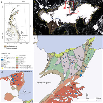
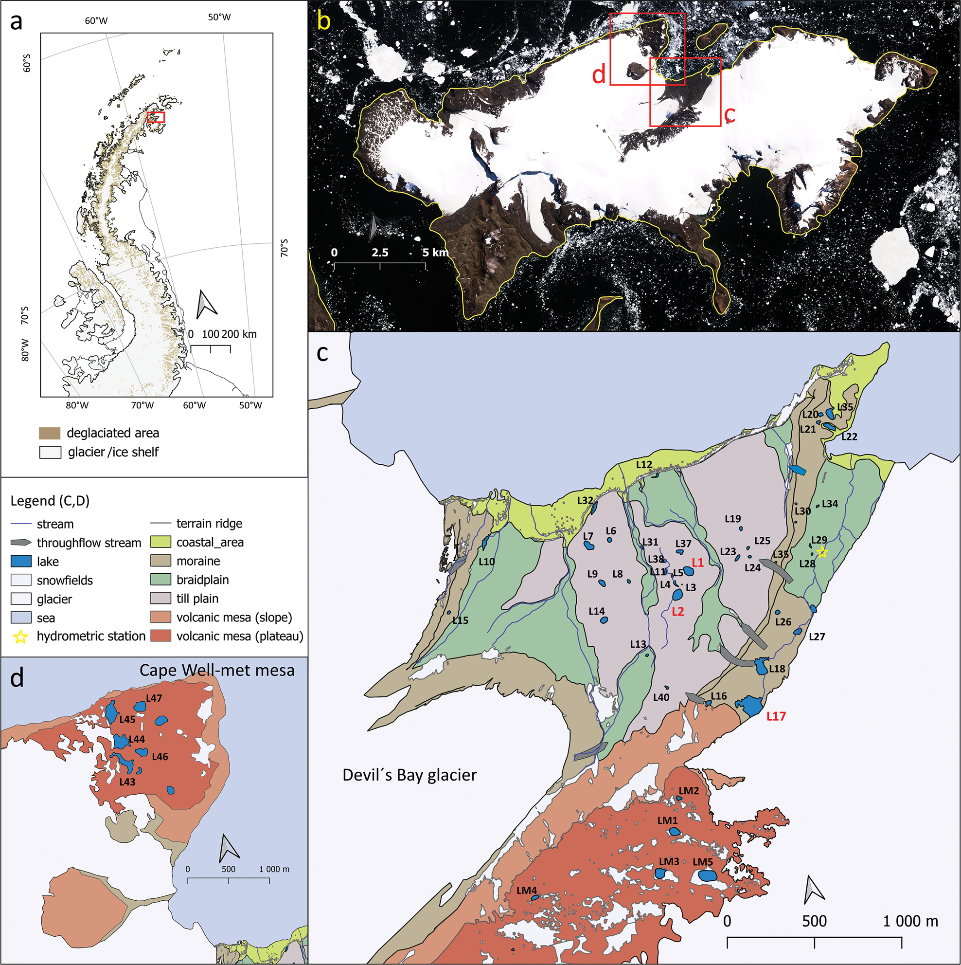
The study site is located off the north-eastern side of the Antarctic Peninsula, where the James Ross Archipelago lies, with James Ross, Vega, Snow Hill and Seymour islands comprising the largest islands. The area of Devil's Bay is situated in the northern part of Vega Island (Fig. 1). The ice-free area (~12 km2) is surrounded by adjacent ice caps on volcanic mesas with three prominent outlets, out of which the largest one is named Glaciar Bahía del Diablo (i.e. ‘Devil's Bay Glacier') (Marinsek & Ermolin Reference Marinsek and Ermolin2015). The basement of Vega Island is made up of Late Cretaceous marine sediments (Marambio Group of the James Ross Basin infill), which are formed of sandstone, mudstone and conglomerate of the Santa Marta, Snow Hill Island and López de Bertodano formations. The elevated volcanic mesas are shaped by basaltic into trachybasaltic rocks (Košler et al. Reference Košler, Magna, Mlčoch, Mixa, Nývlt and Holub2009) of the James Ross Island Volcanic Group (JRIVG) of Miocene to Pleistocene age (Smellie et al. Reference Smellie, Johnson and Nelson2013). Associated subglacial volcanic eruptions produced lava-fed deltas and filled englacial lakes with a typical internal structure of steeply inclined foresets made of hyaloclastite breccias covered by flat topsets of subaerial basalts (Smellie et al. Reference Smellie, Johnson, McIntosh, Esser, Gudmundsson, Hambrey and van Wik de Vries2008). A small amount of related volcanic products that originated from Surtseyan-type hydromagmatic marine eruptions are represented on Vega Island by tuffs and lapilli tuffs (Smellie et al. Reference Smellie, Johnson, McIntosh, Esser, Gudmundsson, Hambrey and van Wik de Vries2008). The Cretaceous basement is covered by Holocene till and glaciofluvial and marine sediments, which are predominantly composed of JRIVG rocks with a smaller proportion of Cretaceous sedimentary rocks.
a. Location of Vega Island in the Antarctic Peninsula Region (data source: SCAR Antarctic Digital Database). b. Vega Island with location of study area split into two parts: red rectangles identify the close-up maps in c. and d. (data source: Sentinel-2 images from 29 December 2018). c. Overview of the main geomorphological features of the ice-free area in front of Glacier Bahía del Diablo with the positions of studied lakes. d. Geomorphological map of the ice-free area around the Cape Well-met mesa with the locations of the studied lakes. The outputs in c. and d. were derived from a combination of aerial photographs and field Global Positioning System mapping.
The climate of Vega Island is described as cold semi-arid. The mean annual air temperature at J. G. Mendel Station on northern James Ross Island (~25 km to the west, 10 m above sea level (a.s.l.), 63°48′03.4″S 57°52′58.0″W) was −7.0°C (2006–15), with summer daily maxima exceeding +10°C and winter minima dropping below −30°C (Hrbáček et al. Reference Hrbáček, Kňažková, Nývlt, Láska, Mueller and Ondruch2017). Variations of interannual temperature strongly relate to the extent and persistence of sea ice, which mostly affects the temperature above the low-lying and seashore-proximal areas of northern James Ross Island, where a year-round temperature inversion has been observed (Ambrožová et al. Reference Ambrožová, Láska, Hrbáček, Kavan and Ondruch2019). The whole James Ross Archipelago lies in the precipitation shadow of the Antarctic Peninsula, with annual precipitation estimates of 300–500 mm of the water-equivalent (van Lipzig et al. Reference Van Lipzig, King and Lachlan-Cope2004). Importantly, high-speed winds have been observed to redistribute snow accumulations from flat surfaces and depressions (Kavan et al. Reference Kavan, Nývlt, Láska, Engel and Kňažková2020).
Material and methods
Field geomorphological mapping and limnological measurements
Water temperature, conductivity and pH was measured in the field with a Hanna Combo handheld device (Hanna Instruments, USA). Most of the lakes researched were visited more than once to record the variability of these parameters.
Automated measurement of water temperature and hydrostatic pressure at 15 min intervals was undertaken using a DipperLog (Heron Instruments, Canada) at Lake Anónima (L2) and Lake Verde (L1) between 16 January and 21 February 2013. Atmospheric variables were measured at the same interval close to both lakes (i.e. 400 m to the south) using Minikin Rh and MiniLog hp Temp (EMS Brno, Czech Republic). The discharge time series of the proglacial stream connected to ‘Lake Payer', used here to demonstrate the interconnections between lake areal extent and external factors, was obtained with the use of a handheld acoustic Doppler current profiler (FlowTracker, YSI, USA) for discharge measurements and DipperLog (Heron Instruments, Canada) for hydrostatic pressure recordings. The water level was calculated after atmospheric pressure compensation of the hydrostatic pressure recordings. A flow duration curve was constructed on the basis of the measured discharge and water-level recordings. For a more detailed description of the discharge time series see Kavan et al. (Reference Kavan, Ondruch, Nývlt, Hrbáček, Carrivick and Láska2017), where the process is described for adjacent James Ross Island.
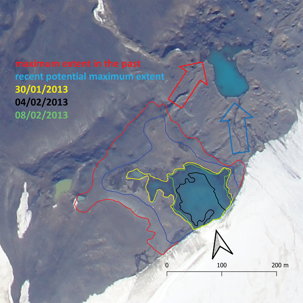
The areal extent of ‘Lake Payer’ (L17) was recorded directly with a handheld Global Positioning System (GPS) device and remotely by repeated photographs from the glacier surface above the lake. These photographs were later georeferenced, an orthophotograph was constructed and the extent of the lake was delimited in ArcGIS software. The recent maximum potential extent of the lake was recorded with a GPS device along the visible shoreline connected to the present outflow of the lake basin. Similarly, the physical proof of the past maximum shoreline was used to delimit its past extent. The past maximum shoreline was connected to the past outflow of the lake. The aerial photographs together with field mapping were used to determine the geomorphological map of the area (Fig. 1c & d). This was later used to distinguish different lake types that were found in the area.
Sampling and hydrochemical analyses
A subset of lakes was chosen for a detailed analysis of water chemistry. It was impossible to sample all of the lakes and transport the physical samples from the field due to logistical constrains. The subset was selected to represent all major lake types, thus covering the variability of the study site. The water samples were taken from the shore using 500 ml plastic bottles previously cleaned with distilled water. The water samples were first filtered through a plankton net (40 μm mesh size) to remove any zooplankton and large particles, kept in the cold and darkness and frozen upon arrival at the Marambio base (64°14′27.4″S 56°37′44.2″W). The samples were analysed in the laboratory at the T. G. Masaryk Water Research Institute (Prague, Czech Republic). Acid-neutralizing capacity (ANC, determined by Gran titration), total concentration of phosphorus (TP) and total concentration of nitrogen (TN) were determined directly in samples from the field without any additional filtration. Glass-fibre filters (pore size 0.7 μm) were used for all analyses except for determining dissolved organic carbon (DOC), which was performed on a total organic carbon/TN FormacsHT analyser (Skalar, The Netherlands) after filtration through membrane filters with a pore size of 0.45 μm. Ion concentrations were determined by ion chromatography, and inductively coupled plasma optical emission spectroscopy (ICP-OES) was used for the determination of Na+, K+ and Ca2+. The molybdate method was applied for determining TP (Murphy & Riley Reference Murphy and Riley1962). TN was analysed after oxidation to nitrogen oxides using the chemiluminescence method (Drushel Reference Drushel1977).
To perform multivariate statistical analyses of the hydrochemical dataset that also included two closely located lake districts on James Ross Island (the Ulu Peninsula (Nedbalová et al. Reference Nedbalová, Nývlt, Kopáček, Šobr and Elster2013) and Clearwater Mesa (Roman et al. Reference Roman, Nedbalová, Kohler, Lirio, Coria and Kopáček2019)), we used the program CANOCO 5 (Microcomputer Power, USA). As the gradient lengths were short, we performed a principal component analysis (PCA) to visualize the variability within the dataset.
Results
Lake types and hydrology
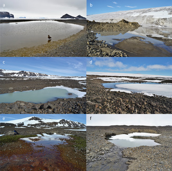
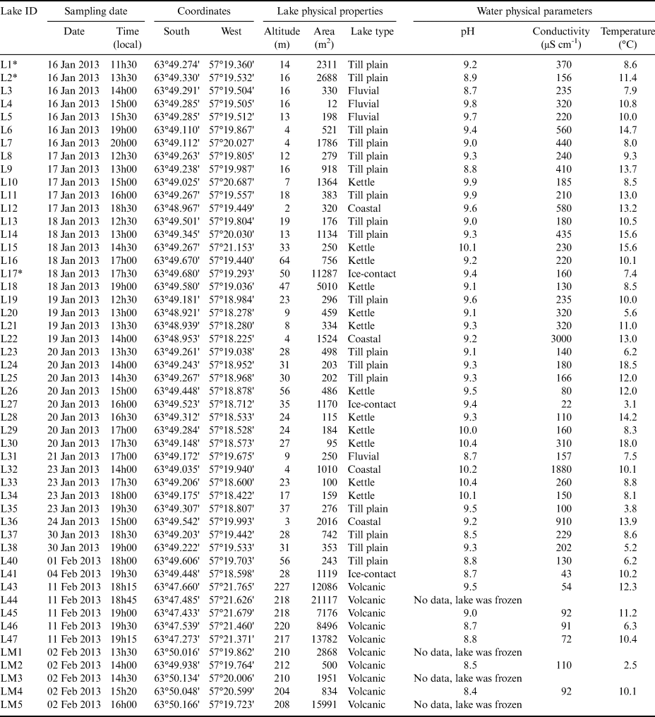
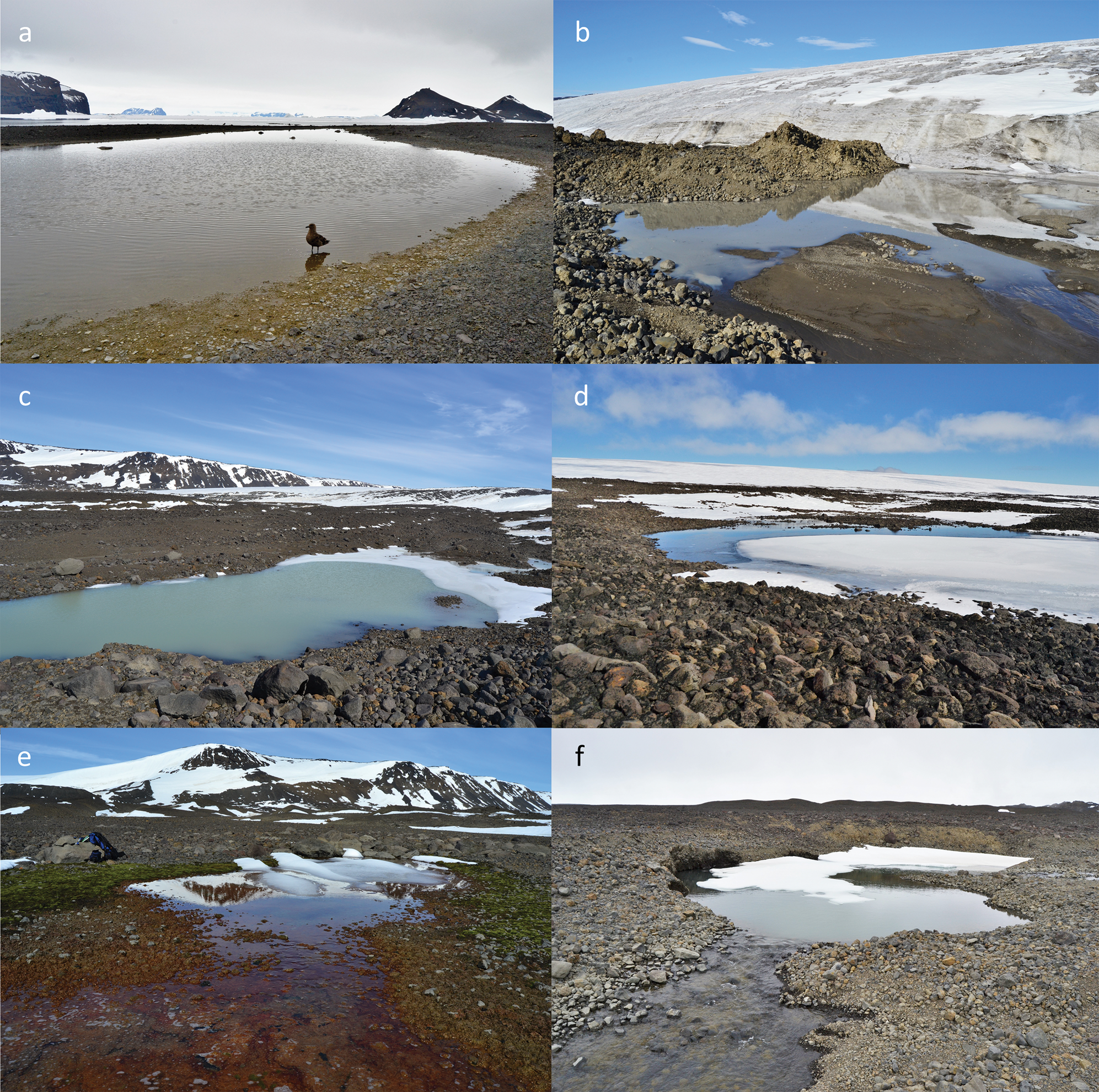
We defined six different types of lakes based on their geomorphological and limnological characteristics. The highest and most stable are shallow lakes on higher-lying volcanic surfaces, which are located both on the Cape Well-met mesa and on an unnamed mesa in the central part of the island (Fig. 1c & d). The most common are lakes and ponds within the till plain and stable moraines in front of Glaciar Bahía del Diablo. Such lakes are stable and could be up to 4.6 m deep. Through-flow fluvial lakes are found in the braidplain of the Glaciar Bahía del Diablo proglacial zone. Kettle lakes have developed in degrading ice-cored moraine ridges on both sides of the proglacial zone. These lakes might be quite deep, but are generally very unstable. Ice-contact lakes located on the eastern side of the ice-free area dammed between the ice-cap margin and the lateral moraine ridge are rather large and deep. The last group of lakes includes coastal lakes, which are represented by quite shallow and rather stable lakes located between the ridges of beaches or resembling cut-off lakes. Examples of all lake types are illustrated in Fig. 2, and a list of all 50 lakes studied, their field-measured parameters and their classification according to lake type are given in Table I.
Photographs of the six basic lake types: a. coastal lakes (L32), b. ice-contact lakes (L27), c. kettle lakes (L10), d. shallow lakes on higher-lying volcanic surfaces (LM4), e. till plain and stable moraine lakes (L8) and f. through-flow fluvial lakes (L31).
List of lakes with basic field-measured parameters and classification into lake types.
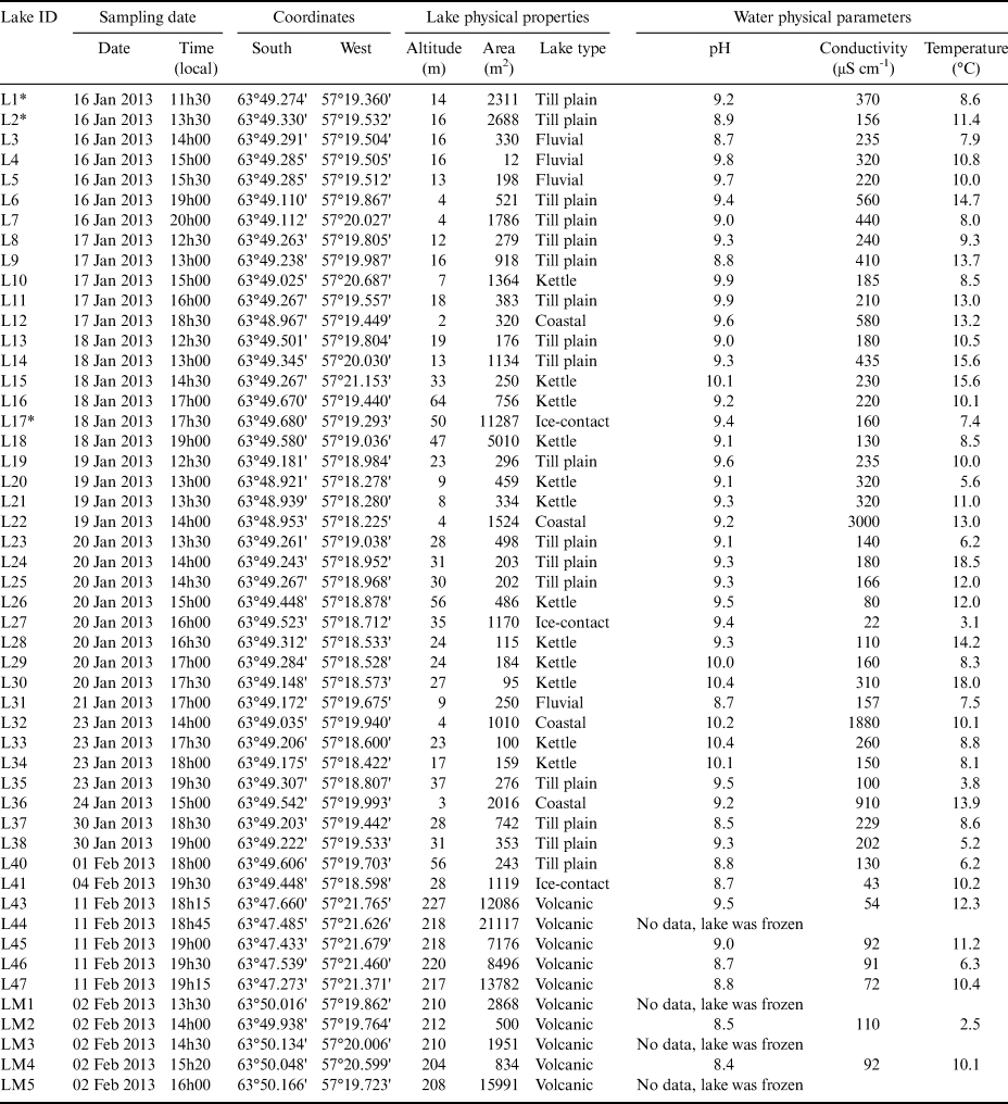
Notes: Shallow lakes on higher-lying volcanic surfaces are labelled ‘Volcanic'. Names of three lakes used in the text: L1* (Lake Verde), L2* (Lake Anónima) and L17* ('Lake Payer').
In general, the lakes experience a period of long ice cover extending approximately from March to December. Important differences in the duration of ice cover are probably connected to specific lake characteristics such as lake altitude, volume/area ratio or the presence of a permanent inflow of water. Some of the high-altitude lakes on volcanic mesas were ice covered even in the mid-summer season (February). The lakes with a high volume/area ratio such as Lake Anónima (L2) also experienced a shift in ice-cover melt, where the ice cover melted completely only in late January. Most of the lakes (apart from the lakes on volcanic mesas) are situated in low-lying areas between sea level and 64 m a.s.l.
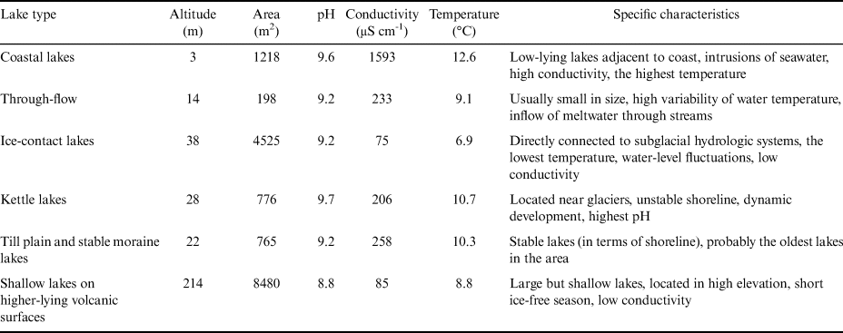
The lakes studied were characterized by relatively high pH (8.4–10.4). The highest pH is found in the kettle lakes and the lowest pH is found in lakes on higher-lying volcanic surfaces. The high variability of conductivity, ranging from 22 μS cm−1 to over 3000 μS cm−1, corresponds with different bedrock types, the proximity of the marine environment and the presence of glacier meltwater inflow. Very low conductivity was characteristic of ice-contact lakes, especially because of the direct inflow of glacier meltwater. The highest conductivity was found in coastal lakes because of the direct intrusion of seawater into the lake or the presence of sea spray, both being important sources of mineral ions. The actual water temperature was highly variable and depended on the time of the measurement (diurnal cycle) and the phase of the summer season. It ranged from 2.5°C up to 18.5°C. The lower water temperature was usually associated with ice-contact lakes, where the inflow of nearly 0°C glacier meltwater affected the overall lake water temperature. In contrast, the highest temperature was found in shallow coastal or till plain lakes, where the effect of the long ice-free season enhanced the radiation forcing, resulting in the highest recorded water temperatures. The lake parameters are summarized in Table I.
Shallow lakes on higher-lying volcanic surfaces
Lakes in this group are characterized as being relatively large but very shallow (< 0.5 m). They are located on volcanic mesa plateaux between 200 and 250 m a.s.l. and are clustered into two distinct groups (north and south of the main area). All lakes have relatively low conductivity (54–110 μS cm−1) and low pH ranging from 8.4 to 9.0, with one exception of L43 (pH 9.5). Based on these field measurements, only two out of six lakes (LM2 and L46) had a water temperature < 10°C (2.5°C and 6.3°C, respectively). The temperature measurements were probably a result of the long duration of ice cover, as the lakes were sampled just after ice melting (2 February 2013 and 11 February 2013). The relatively high water temperatures of the other four lakes (10.1–12.3°C) correspond with the longer duration of the ice-free surface period, while the shallow depth is associated with a rapid temperature increase of the water during the clear sky days. In general, the lakes on the volcanic mesas are stable (in terms of their shape and depth profile) and up to several hundreds of years old. The surface did not change after deglaciation.
Till plain and stable moraine lakes
Lakes on the till plain and stable moraines are the most numerous (21 out of 50). They are located in front of Glaciar Bahía del Diablo within a small area on the surface that has been left ice-free after the Holocene glacier retreat. They are relatively small compared to the shallow lakes on higher-lying volcanic surfaces, but significantly deeper. Lake Anónima (L2) reaches a maximum depth of 4.6 m. The shorelines of these lakes are stable, and the deepest of them do not freeze completely during the winter. Their temperature regime is highly dependent on lake depth, and the actual water temperature can vary significantly from 3.2°C in the deep lakes up to 18.5°C in the shallow lakes susceptible to rapid warming by high solar radiation. The average conductivity is 258 μS cm−1, ranging from 100 to 560 μS cm−1. The pH values are between 8.5 and 9.9, which is slightly lower than the pH recorded in kettle or coastal lakes in the region. The lakes are probably the oldest in the area, and possibly > 2000 years old, as revealed from lacustrine sediment records. The deglaciation of the low-lying areas in adjacent James Ross Island is dated to the Early Holocene.
Through-flow fluvial lakes
Lakes characterized by the through-flow regime had similar characteristics to the lakes in the till plain and stable moraines, including their morphology and position within the same area. The fundamental difference is in their direct connectivity to fluvial systems, which significantly affects their physical and chemical parameters. Unlike the till plain and stable moraine lakes, the through-flow lakes have a relatively stable water temperature, reflecting the less variable fluvial regime. The temperature of the four lakes varied from 7.5°C to 10.9°C. Average conductivity is 233 μS cm−1 (157–320 μS cm−1), reflecting the geology of the till plain and stable moraine and corresponding well with the conductivity of the till plain and stable moraine lakes. Water pH is variable, ranging from 8.65 to 9.75, probably reflecting the specific conditions of the whole catchment. Similarly to the till plain and stable moraine lakes, these lakes may have originated soon after deglaciation of the area in Early/Mid-Holocene.
Kettle lakes
Kettle lakes are the second most common type of lakes in the area (12 out of 50). They occupy the recently (after the Little Ice Age, terminated c. 300 years bp) deglaciated areas in front of the local glaciers; thus, they can be dated to only a few decades ago. In comparison with lakes on till plains and stable moraines, this group is distinguished by a very unstable shoreline and lake morphology. They are located in young, unconsolidated moraines. Often, their water is full of glacial flour (suspended fine-grained glacigenic sediments). These lakes can be deep (up to 5 m); however, their morphology is still developing, and dynamic slope processes associated with ice decay can change the shape and depth of the lake significantly. In contrast with the lakes on the till plain and stable moraines, kettle lakes are very young and can be substantially affected by sedimentation, slope processes and lake outburst. Their temperature is variable, ranging from 5.6°C to 18.0°C, with an average temperature of 10.7°C. The actual temperature again differs significantly according to the area, the depth of an individual lake and also according to the date and time of measurement. They have slightly lower conductivity (average 206 μS cm−1) than stable moraine lakes. On the other hand, their pH is the highest of all of the lake types, with a mean value of 9.7.
Ice-contact lakes
There are three lakes in direct contact with the glacier and glaciofluvial system (L17, L27 and L41). These lakes are fed mainly from the subglacial fluvial system adjacent to the glacier in the south-eastern part of the study area. These lakes could also be identified as kettle lakes; however, their direct relationship with the glacier fluvial system gives them specific physical and chemical characteristics (e.g. low conductivity and temperature and high water-level fluctuations). The average temperature was 6.9°C, with a minimum temperature of only 3.1°C in lake L17 ('Lake Payer'). This is caused by the direct inflow of cold meltwater. The same meltwater effect is responsible for the low conductivity of these lakes, which is on average only 75 μS cm−1 (range 22–160 μS cm−1). In contrast to their low temperature and conductivity, the pH value for this group of lakes is on average 9.2. Apart from the specific physical and chemical properties (low temperature and conductivity), the lakes are also characterized by highly variable water-level fluctuations. This applies especially in the case of ‘Lake Payer', which is described in further detail below. As the origins of the lakes are directly connected to glacier retreat, these lakes are only a few years or decades old, similarly to the region's kettle lakes.
Coastal lakes
Lakes are located in the coastal area and their origin is directly linked with the shore evolution. These lakes are separated from the sea by beach ridges formed by sedimentation as a result of wave action. They are characterized by an elongated shape that is parallel with the coastline. The lakes are rather shallow, occasionally hydrologically connected to the sea during high tide or through the subsurface water connection, which is reflected in their high conductivity, ranging from 580 to 3000 μS cm−1, with an average of 1593 μS cm−1. The average water temperature for this group rises to 12.6°C due to their very shallow depth and low altitude, making it the warmest lake group type. The coastal lakes also had high pH values, which, together with kettle lakes, makes them the most alkaline of all the lake types found in the region.
Lake water physical and chemical properties
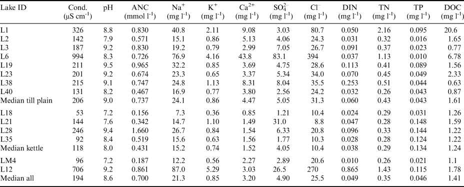
The hydrochemical analysis performed on a subset of lakes showed that their chemical composition was highly variable (Table II). Generally, the proportions of major ions were similar to seawater, and their concentrations reflected a strong marine influence that was most pronounced in the lakes close to the coast (L6 and L12). Chloride dominated the ionic composition in till plain and coastal lakes, with Cl- concentrations reaching 0.4 g l−1 in L6. A comparison of major ion ratios between the lake samples and seawater showed increased proportions of bicarbonate and Ca2+, suggesting that the catchments were the source of these components. The DOC concentrations ranged from 0.6 to 20.6 mg l−1 (median 1.4 mg l−1), with the highest values detected in Lake Anónima (L2). The TN values in most lakes varied from 0.26 to ~1.00 mg l−1, with higher concentrations in L1, L6 and L12. Dissolved inorganic nitrogen formed < 30% of TN in most of the lakes, suggesting that organic nitrogen was the prevailing form. The highest TP values (> 0.1 mg l−1) were found in the coastal L12 and in the kettle lakes. Overall, substantially higher ion and nitrogen concentrations were detected in the coastal and the till plain lakes in comparison with the kettle lakes (Table II).
Chemical characteristics of water samples from a subset of lakes based on laboratory analysis.
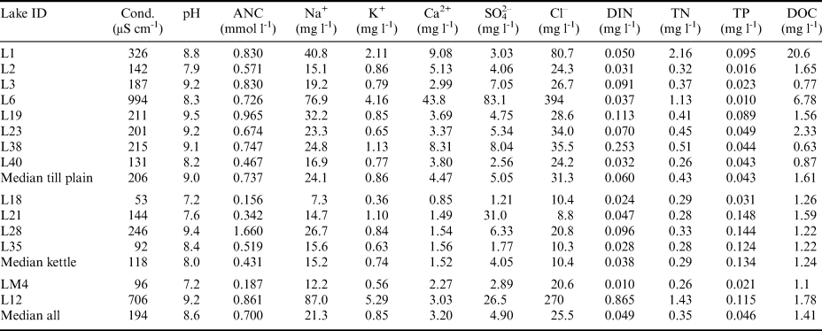
Conductivity and pH are laboratory values.
ANC = acid-neutralizing capacity, Cond. = conductivity (at 25°C), DIN = dissolved inorganic nitrogen, DOC = dissolved organic carbon, TN = total nitrogen, TP = total phosphorus.
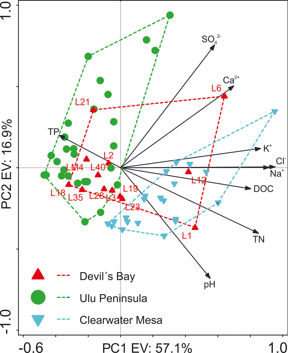
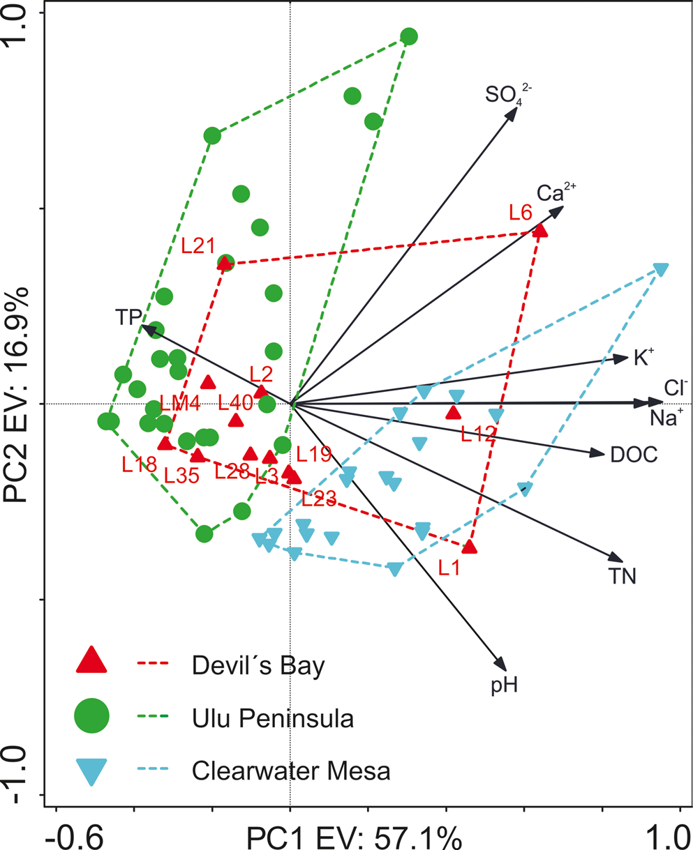
The PCA of the hydrochemical dataset confirmed the high variability of the lakes in the Devil's Bay area (Fig. 3). The first component explained ~57% of the variability and was clearly correlated with the concentration of major ions (associated with conductivity) and DOC. There was also a clear negative correlation between TN and TP values, with higher TP and lower TN found on the Ulu Peninsula compared to the Clearwater Mesa lakes. The comparison with the neighbouring lake districts on James Ross Island showed an intermediate position of the newly studied lakes with respect to the first axis of the PCA. However, there was a clear overlap, especially with the Ulu Peninsula lakes indicating a similar chemical composition of lake water.
Principal component analysis of the chemical parameters of the Devil's Bay area (Vega Island), Ulu Peninsula and Clearwater Mesa lakes (both James Ross Island). For lake codes, see Table II. DOC = dissolved organic carbon, TN = total nitrogen, TP = total phosphorus. The percentages of the variability explained (EV) by the first (PC1) and second (PC2) axes are given. The data on the James Ross Island lakes are from Nedbalová et al. (Reference Nedbalová, Nývlt, Kopáček, Šobr and Elster2013) and Roman et al. (Reference Roman, Nedbalová, Kohler, Lirio, Coria and Kopáček2019).
Seasonal surface fluctuation of ice-contact ‘Lake Payer'
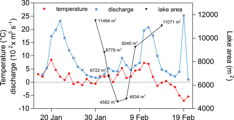
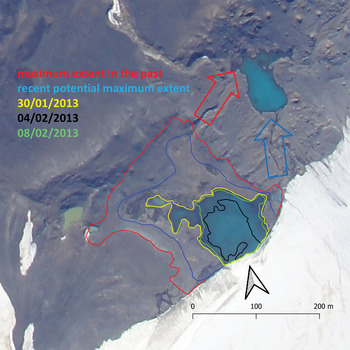
‘Lake Payer’ (L17), the third largest lake of the area, is characterized by a fluctuating water level and consequently also by surface fluctuation. This is caused by its direct connection to the subglacial fluvial system and is a consequence of the amount of meltwater as the single source of water for the lake. The maximum extent of the lake for the 2013 season covered an area of 1.13 ha (recorded 30 January 2013). This maximum extent was reached for a short period of time during the 2013 summer season. After the maximum extent on 30 January, the lake area gradually decreased for ~10 days and then reached a new maximum on 14 February. There was some correlation between lake extent and basic atmospheric parameters (air temperature and atmospheric pressure) (Fig. 4). The parameter correlating most closely with lake surface extent was the discharge measured at a proglacial stream of the glacier ~1 km downstream. The lake system has rather long inertia and reacts with a time lag of ~5–6 days, which is evident from the discharge curve, where the minimum daily discharge on 30 January is followed by the minimum areal extent of the lake on 4 February. The areal extent changes, based on a combination of both methods regarding atmospheric and fluvial characteristics, are illustrated in Fig. 5.
‘Lake Payer’ areal extent dynamics during the 2013 summer season (black line) in relation to mean daily air temperature, atmospheric pressure and mean daily discharge of the proglacial river downstream of the lake.
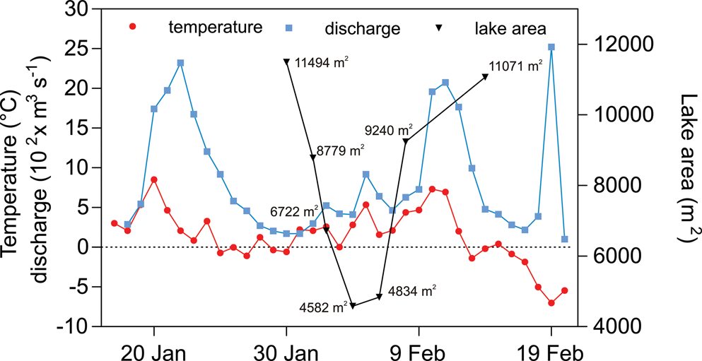
Areal extent of ‘Lake Payer’ (L17) based on Global Positioning System measurements combined with georeferencing of photographs.
Lake Anónima and Lake Verde water-level and temperature fluctuation
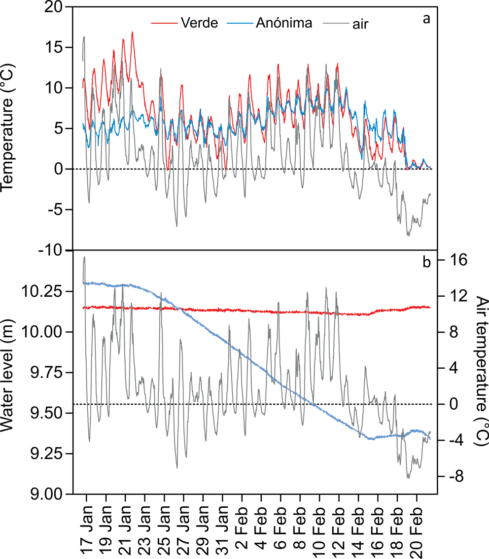
A significant difference in water-level fluctuation dynamics was found in both Lake Anónima and Lake Verde. Whereas Lake Anónima experienced a significant decrease in water level during the summer season, Lake Verde showed no clear reaction to atmospheric factors during the season (Fig. 6). The water level of Lake Anónima decreased 0.97 m between 16 January and 14 February 2013. This change in the water level represents a decrease in lake area to 52% of the original area at the beginning of the season (from 0.27 to 0.14 ha). The main phase of the decrease from 21 January to 14 February 2013 is characterized by a gradual decrease in lake area without any abrupt changes. The phase of water-level decrease corresponds to the prolonged warm period with air temperatures > 0°C and consequently also to warm water temperatures. The gradual decrease stopped after a significant decrease in air temperature from 12 February (with a daily average temperature of 7.0°C) to 13 February (2.0°C) and temperatures < 0°C from then on (Fig. 6). The increase in the lake water level was caused by snowfall that brought with it a substantial amount of water. Lake Verde experienced only a 0.04 m decrease during the same period, which could correspond to evaporation enhanced by a strong wind. The increase in water level at the end of the season demonstrated the same pattern as recorded at Lake Anónima, supporting the suggestion that snowfall was the cause of the change.
a. Water temperatures in Lake Verde, Lake Anónima and air temperature and b. water levels for Lake Verde and Lake Anónima.
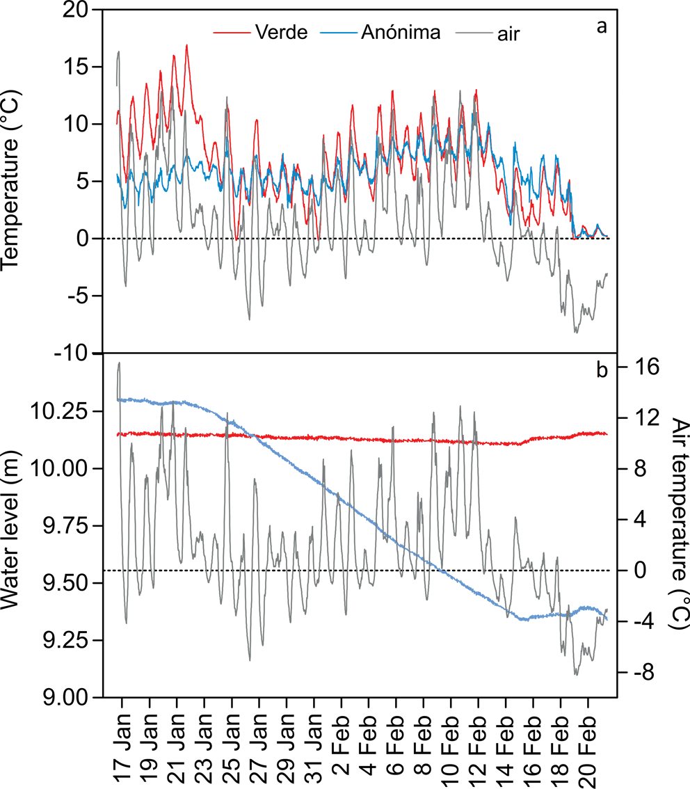
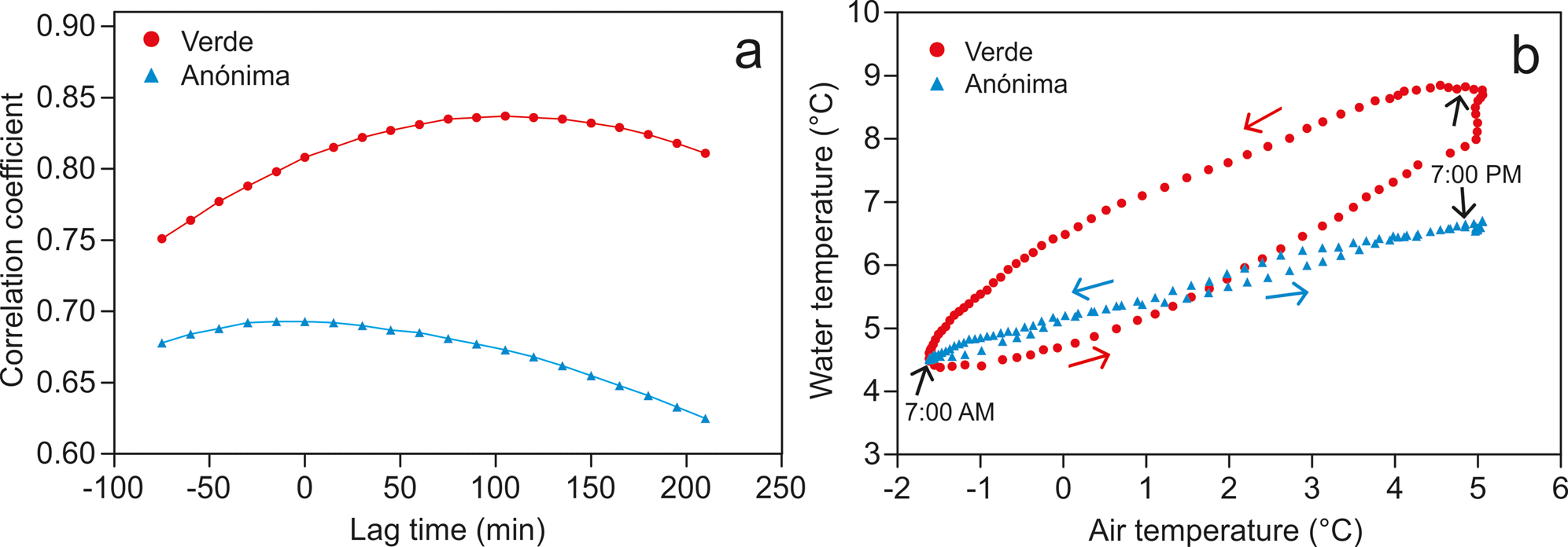
Average water temperature during the study period reached 6.55°C in Lake Verde and 5.59°C in Lake Anónima. Both lakes experienced diurnal variation in water temperature corresponding to diurnal fluctuation of air temperature. The correlation coefficients of air temperature and water temperature were 0.69 for Lake Anónima and 0.81 for Lake Verde. The standard deviation of water temperature for Lake Verde was 3.66, whereas it was only 2.15 for Lake Anónima. The difference in average temperature and thus temperature variability can be attributed to difference in depth (correspondingly to lake volume): Lake Anónima was deeper (down to 4.6 m), whereas Lake Verde was only 1 m deep. This made Lake Verde more responsive to external atmospheric forcings. There was also a surface inflow into Lake Anónima, which can strongly influence water temperature variation towards more stable conditions. It can also negatively influence the correlation coefficient, as air temperature is more variable, whereas the water temperature in Lake Anónima was relatively stable due to the inflow of glacial/snow meltwater of a stable temperature of ~1°C. The relative stability of Lake Anónima in comparison to Lake Verde's water temperature is illustrated in Fig. 6. For example, the marked reaction to a sudden decrease in air temperature is apparent on 22 January 2013 in the case of Lake Verde, but almost no immediate reaction is visible in Lake Anónima's water temperature record.
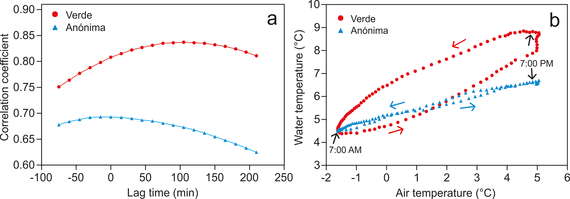
Figure 7 illustrates the detailed relationship between water temperature and air temperature by the means of correlation coefficient lag time (Fig. 7a). The correlation coefficients for the Lake Anónima and Lake Verde water temperatures in terms of their subsequent lag times show the different reactions of both lakes to air temperature forcing. There is no lag time in the case of Lake Anónima because of the constant inflow of stream water. This rapid exchange of water ensures an immediate reaction to air temperature (through fluctuations of the inflow water temperature). Lake Verde, in contrast, has no water inflow and thus reacts directly to air temperature, which results in almost 2 h of lag time: the water temperature peak follows the air temperature peak after ~100 min. The same effect is visible in the case of the hysteresis pattern (Fig. 7b). Lake Anónima experiences a narrow hysteresis loop, while Lake Verde has a wide one, suggesting the delayed water temperature peak.
a. Lag time of the water temperature and air temperature and b. hysteresis patterns in the water temperature/air temperature relationships at Lake Verde and Lake Anónima.
Discussion
Devil's Bay, with its 12.1 km2 of surface area, is one of the most important deglaciated areas of the eastern part of the Antarctic Peninsula. It has a higher density of lakes in comparison with nearby lake districts, such as the Ulu Peninsula (Nedbalová et al. Reference Nedbalová, Nývlt, Kopáček, Šobr and Elster2013), and a similar number as Clearwater Mesa on James Ross Island (Roman et al. Reference Roman, Nedbalová, Kohler, Lirio, Coria and Kopáček2019). Until recently, freshwater ecosystems on the eastern side of the Antarctic Peninsula have received less attention than those on the western side, where detailed limnological surveys have been previously published (e.g. Toro et al. Reference Toro, Camacho, Rochera, Roco, Banon and Fernandez-Valiente2007). In addition, the current concept of Antarctic biogeography recognizes the north-east Antarctic Peninsula as a separate region (Terauds & Lee Reference Terauds and Lee2016). It is thus crucial to document its current environmental conditions to enable thorough analyses of the factors underlying the differences in biodiversity patterns among regions and the effects of climate warming on these ecosystems.
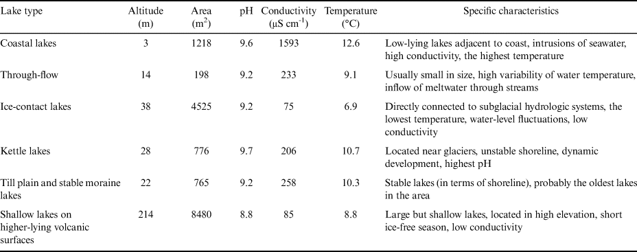
The chemical compositions of the lakes in the Devil's Bay area were very variable, reflecting the differences in their geomorphological position, age and bedrock that are associated with the different lake types described in this study (Table III). The high diversity of lake types found within the relatively small area of the Ulu Peninsula was also recently shown to underlie the differences in water chemistry of the neighbouring lakes (Nedbalová et al. Reference Nedbalová, Nývlt, Kopáček, Šobr and Elster2013). Overall, the newly created dataset revealed a clear difference between the relatively old till plain/stable moraine lakes and young kettle lakes, with the latter being characterized by lower concentrations of major ions, TN, TP and pH. A significant effect of lake age on water chemistry was also observed within the Ulu Peninsula dataset (Nedbalová et al. Reference Nedbalová, Nývlt, Kopáček, Šobr and Elster2013). However, an analysis of a larger set of water bodies equally covering all of the lake types will be necessary to gain deeper insights into the chemical variability of the studied area.
Lake-type characteristics with mean values of altitude, area, pH, conductivity and water temperature.
Recently, Lecomte et al. (Reference Lecomte, Vignoni, Córdoba, Chaparro, Chaparro and Kopalová2016) presented a thorough multidisciplinary comparison of James Ross archipelago lakes, including lakes on Vega, Seymour-Marambio and James Ross islands. Their data were obtained from a limited number of lakes from each island (most of the lakes from Devil's Bay are located in close vicinity to Lake Anónima), so the dataset also cannot be regarded as representative of the whole ice-free area. Although far from complete, our comparison of the water chemistry of the lakes from Devil's Bay, the Ulu Peninsula and Clearwater Mesa includes a larger geographical area on both Vega and James Ross islands and shows a large gradient of chemical conditions going from the most diluted kettle lakes on the Ulu Peninsula to the lakes with the highest concentration of chemicals found on Clearwater Mesa (Roman et al. Reference Roman, Nedbalová, Kohler, Lirio, Coria and Kopáček2019). The Devil's Bay lakes occupy an intermediate position: the high variability of parameters associated with conductivity supports the presence of diverse flora in the lakes (Bulínová et al. Reference Bulínová, Kohler, Kavan, Van De Vijver, Nývlt and Nedbalová2020).
The contrasting water-level regime of Lake Verde and Lake Anónima results from the different morphologies of both lakes, even though the two lakes are located only ~50 m from each other. Lake Verde is rather shallow (~1 m maximum depth) and is surrounded by a large till plain, whereas Lake Anónima exceeds a depth of 4.6 m and only a narrow ridge of till material forms the dam preventing the lake from outflow. The decrease of the water level of Lake Anónima during the summer season corresponds well with period when temperatures are > 0°C. The high air temperatures in connection with a stable input of water cause the ice to melt inside the ridge on the north-eastern side of the lake. Ice melting in the till dam was also observed by Chaparro et al. (Reference Chaparro, Chaparro, Córdoba, Lecomte, Gargiulo and Barrios2017). The water-level decrease in Lake Anónima apparently occurs each season, as is observed from various satellite and aerial images. Such regular fluctuation connected with seasonal positive temperatures is to be expected in permeable material filled with ice. A decrease in the water level of almost 1 m was reported by Shevnina & Kourzeneva (Reference Shevnina and Kourzeneva2017) in the Progress-Sibthorpe system of lakes (in the Larsemann Hills region) during two consecutive seasons as a result of the break of a snow dam. In contrast, Oliva et al. (Reference Oliva, Antoniades, Giralt, Granados, Pla-Rabes and Toro2016) reported several rapid increases in the water level due to blocking of the lake outlet by snow in their study from South Shetland Islands. The water-level fluctuations in Lake Anónima were caused by melting ice in the till dam during the positive air temperatures and are therefore rather unique in comparison to other lakes with similar levels of water fluctuation (e.g. Doran et al. Reference Doran, McKay, Fountain, Nylen, McKnight, Jaros and Barrett2008, Castendyk et al. Reference Castendyk, Obryk, Leidman, Gooseff and Hawes2016, Oliva et al. Reference Oliva, Antoniades, Giralt, Granados, Pla-Rabes and Toro2016, Toner et al. Reference Toner, Catling and Sletten2017).
Prominent diurnal patterns in water temperature were recorded in both Lake Verde and Lake Anónima, reflecting the diurnal patterns of air temperature and solar radiation. A more pronounced diurnal fluctuation was observed in Lake Verde, which may be due to the specific morphology of the lake basin (i.e. shallow with low or almost no water inflow). On the other hand, the diurnal temperature regime of Lake Anónima is rather uniform, varying between 4°C and 8°C during most of the summer season (Fig. 6a). Lake morphology and its relationship with its surroundings are also reflected in the lag time and hysteresis pattern of the water temperature (Fig. 7). Lake Anónima, with a narrow hysteresis loop, reflected relatively low variability in water temperature. This is a characteristic feature of glacier-fed systems affected by the inflow of meltwater (van Vliet et al. Reference Van Vliet, Ludwig, Zwolsman, Weedon and Kabat2011). There is almost no lag time between water and air temperatures in the case of Lake Anónima, as the lake almost instantaneously reflects the variation in air temperature, especially through the constant inflow of water in the lake.
The fluctuation of the water level in ‘Lake Payer’ strongly reflects the overall atmospheric conditions (air temperature) and consequent glacier melt. This is typical of lakes directly connected to glaciers, as these glaciers are their most important or only source of water. Such fluctuations dependent on atmospheric forcings are known from continental Antarctica, even though they occur over much longer timescales (e.g. Webster et al. Reference Webster, Hawes, Downes, Timperley and Howard-Williams1996, Bomblies et al. Reference Bomblies, McKnight and Andrews2001, Castendyk et al. Reference Castendyk, Obryk, Leidman, Gooseff and Hawes2016).
Conclusions
The first systematic geomorphological mapping and description of the physical and chemical parameters of lakes in the Devil's Bay area are presented here. The lakes were classified according to their origin and recent geomorphic setting into six major groups. Based on this description and data analysis, we conclude:
• The relatively small ice-free area of 12 km2 is characterized by a higher density of lakes when compared to the nearby Ulu Peninsula and shares a similar density with Clearwater Mesa on James Ross Island.
• The high limnological diversity of the area is demonstrated by the presence of six lake types; the most abundant lake type (21 out of 50 lakes) consists of lakes on till plains and stable moraines.
• Very stable and long-lasting lakes as well as highly dynamic lakes with variable water levels were described. All identified lake types are usually directly connected to the glacier hydrological system, which provides the most significant source of water for the lakes.
• The hydrochemical parameters of the Devil's Bay area lakes vary greatly, reflecting the differences in lake types and bedrock. In the context of nearby lake districts that have been recently described in other studies, they occupy an intermediate position: more diluted lakes were found on the Ulu Peninsula, whereas Clearwater Mesa has lakes with higher conductivities.
Acknowledgements
Special thanks are given to the staff of J. G. Mendel Station for the field assistance, as well as to Marcos A.E. Chaparro and all field members of the Picto project. We appreciate the help of two anonymous reviewers and Kevin Hughes (editor) for comments and suggestions.
Author contributions
JK was responsible for the fieldwork, study design and editing of the manuscript. LN contributed by processing the water samples and interpreting the chemical characteristics. DN interpreted the geological settings of the area and helped to define the lakes types. TC helped with writing the manuscript. JML was responsible for the logistics of the field campaign and contributed to the writing of the manuscript.
Financial support
This work was supported by the Czech Science Foundation project GC20-20240S, the Ministry of Education, Youth and Sports of the Czech Republic project no. LM2015078, Masaryk University project MUNI/A/1356/2019, Instituto Antárctico Argentino (logistical and financial support for the field campaign) and PICTO project 2010-0096.
Details of data deposit
The data that support the findings of this study are available from the corresponding author upon reasonable request.