Recent research into the complex phenomenon of the Maya Terminal Classic (hereafter TC) collapse has prioritized politico-cultural units such as polities, kingdoms, centers, and dynasties of rulers (e.g., Iannone et al. Reference Iannone, Houk and Schwake2016; Okoshi et al. Reference Okoshi, Chase, Nondédéo and Arnauld2021), as well as ecological regions (e.g., Dunning et al. Reference Dunning, Beach and Luzzadder-Beach2012). However, cities, which are agglomerations where sedentary social groups frequently interacted, have rarely been considered as analytical units (e.g., Halperin et al. Reference Halperin, LeMoine and Pérez Zambrano2019; Hoggarth and Awe Reference Hoggarth, Awe and Faulseit2016; Lamoureux et al. Reference Lamoureux-St-Hilaire, Macrae, McCane, Parker and Iannone2015), despite the fact that the modification or abandonment of houses and public buildings has left many traces (Aimers et al. Reference Aimers, Hoggarth and Awe2020). This study aims to analyze the rich and diverse archaeological, epigraphic, and iconographic records (e.g., Demarest et al. Reference Demarest, Rice and Rice2004) by means of a database designed to cover urban dynamics during the relatively long TC process that many regard as a transformation rather than a collapse (e.g., Chase and Chase Reference Chase, Chase, Schwartz and Nichols2006). TC cities, towns, and large villages are useful units through which to observe the changes produced by collective agency before eventual abandonment.
While the idea of a complete collapse is inadequate on a broad scale since the Late Postclassic Maya societies eventually regained prosperity and resisted the European conquest, a more specific concept of collapse applies to the Classic lowland political regime. A series of events, recently recognized and dated to the early ninth century, ended many, if not most, royal dynasties in a rapid process, that is “the political collapse” (Okoshi et al. Reference Okoshi, Chase, Nondédéo and Arnauld2021). Nearly all cities were subsequently deserted in a distinct and much longer sequence of ups and downs; namely, the achievements and failures experienced by settlements after they lost their dynastic government (e.g., Scherer and Golden Reference Scherer, Golden and Iannone2014). Identifying this later “urban collapse” as a longer and more intricate process spanning the ninth and tenth centuries—in some places extending into the Early Postclassic (AD 1000–1150)—reveals distinct causal factors for the political collapse and the more gradual urban decline. Distinguishing between these two types of collapse provides valuable insights into the phenomenon, especially with regard to the question of how it occurred rather than why (Arnauld Reference Arnauld2024; Lyons and Turner Reference Lyons and Turner II2025).
However, before addressing the causes, it is necessary to organize the abundant and complex archaeological TC datasets. Archaeological signals, such as interrupted public construction, relocated monuments, shifts in commodity distribution, and new imports, among many others, can be reassessed as markers in every city of a collective agency conducive to postdynastic political reorganization in each city. This likely included the reappropriation of urban-“economic” activities by social groups distinct from the extinct royal court. If correctly interpreted, together they may provide structured evidence to help us better understand the transformations of the ninth and tenth centuries and design an approach to the intriguing final desertion. A database was created encompassing as many excavated sites (100) and indicators (29) as possible. The statistical analyses presented in this study aim to assess the relationships between the variables derived from these indicators, which cover the one-phase TC period from AD 760 to 1000. Ideally, the evidence would be ordered chronologically, but we were only able to deal with the unique phase, which conflates, in time, the end of dynasties with the abandonment of cities (see sequences in Demarest et al. Reference Demarest, Rice and Rice2004; but see Halperin et al. Reference Halperin, Carrera, Wolf and LeMoine2024:762). In spite of this drawback (“time-averaged assemblage”; Premo Reference Premo2014), we intend to show that the evidence has the potential to reveal the direction and manner of urban change, justifying the effort involved in defining TC subphases, which is certainly a significant challenge.
As we will see, the subsequent urban change following the dynastic collapse appears to be less influenced by the political upheaval than expected. The positive correlations between several urban-economic activity variables suggest that the TC was a time in which royal cities were more pluralistic—that is, socially and economically open to diverse activities— and that in a small majority of cases their longevity extended into the Early Postclassic period (from AD 950 to 1000 onward). Those relatively prosperous cities remained active for nearly 200 years after the dynastic fall, and for most of them the final demise may have been a response, primarily, to exogenous conditions of urban life created by Mesoamericanization, new trade routes, and climate change.
In this article, we first outline the concepts of change that underpin the database indexing. We then briefly describe how the database was built, before defining our options for data sampling (cities, attributes, and variables) for statistical analysis. Finally, we present and discuss the analyses and results and assess the database’s potential.
From Political Rupture to Urban Demise: Concepts
The Classic Maya collapse is such a broad and complex phenomenon that anthropology will produce numerous data, interpretations, and models before arriving at a comprehensive explanation of two collapses: a political collapse and an urban collapse, and possibly a later demographic recession. This distinction provides a provisional, heuristic device that induces us to consider different causal factors over time and across the Maya Lowlands, while avoiding abrupt concomitancy (Arnauld Reference Arnauld2024). Epigraphic and archaeological evidence now show that the rapid disintegration of Classic Maya divine kingship occurred by AD 810–820, when many large and small kingdoms lost their long-standing dynasties (Grube Reference Grube, Okoshi, Chase, Nondédéo and Arnauld2021; Houston and Inomata Reference Houston and Inomata2009:300–304; Inomata Reference Inomata2021; Martin Reference Martin2020:279–283; see Supplementary Material 1 for details and references).
Not all cities were immediately depopulated, only a few were. Some resumed erecting monuments after a hiatus, others experimented with new regimes, and still others emerged as new centers of power and started erecting monuments. Meanwhile, warfare—although far less publicized (Grube Reference Grube, Okoshi, Chase, Nondédéo and Arnauld2021)—and geopolitical activity continued throughout the ninth century (Martin Reference Martin, Stanton, Taube, Coltman and Comacho2023). Low urban populations in the early ninth century did not necessarily mean immediate desertion, although this was certainly the case in some instances. There is evidence of vibrant activity in towns such as Ucanal (Halperin and Garrido Reference Halperin and Garrido2020), Nakum, Yaxha (Zralka and Hermes Reference Źrałka and Hermes2012a, Reference Źrałka and Hermes2012b), and Naachtun (Sion Reference Sion2016), to name but a few. Even some Early Postclassic occupation has been detected in many settlements. Nevertheless, we know how the story ends, and this knowledge influences our perspective because only six to seven cities survived into the colonial period (in our database, Chichen Itza, Edzna, Ek Balam, Lamanai, Punta de Chimino, Yaxha, and Santa Rosa Corozal).
Rather than disregarding the numerous traces of ninth-century processes merely under the assumption of final failure, it is advantageous to consider them as “direct insider information” (Butzer and Enfield Reference Butzer and Endfield2012:3630) relative to urban agents’ attempts at reorganization. These agents knew that reorganization was needed after the political crisis but were unaware of the eventual outcome, which became apparent only when they permanently closed their houses and departed. The interval encompassing the fall of the kings and the departure of households abandoning their urban residence was a period for action, as evidenced by a wealth of TC archaeological, epigraphic, and iconographic data. Inevitably datasets are disseminated across a variety of publications in diverse formats and follow distinct agendas. Indexing these elements in a database must consistently adhere to local trajectories of cities, employing concepts that circumvent the use of particularistic narratives or abstract cycling. The systematization of the TC evidence ought to be based primarily on a concept of collective agency, considering social groups residing in urban areas as the actors. After the swift disintegration of kingdoms, only agglomerations remained for community reproduction, while hinterlands and rural regions, if not deserted, had sparse, mobile populations. Urban places were shaped by local historical processes and each one had a unique landscape combining infrastructures that sustained subsistence, services, and institutions. Most importantly, they were the theaters for ceremonies (Inomata Reference Inomata2006) that celebrated temporalities (see following text). Neighborhood leaders managed populations, subsistence, trade, and even geopolitics by drawing on infrastructure, the memory of past practices, and shared cultural resources to reconfigure urban form, life, and functions (Marken and Arnauld Reference Marken, Arnauld, Marken and Arnauld2023).
In the framework of historical processualism, agency (e.g., Dornan Reference Dornan2002) guides interpretations of TC Maya archaeology entailing collective action and reflexivity regarding the city’s past and future. For instance, traces of interrupted public construction and an abrupt change in building techniques in the city epicenter may be the result of conscious action by groups of urban residents collectively engaged in terminating and/or transforming public institutions (e.g., Newman Reference Newman2019). These agents developed disruptive strategies, then attempted reorganization and legitimation, consciously drawing on a particular local history they shared while negotiating a vision of the future. The past dimension of reflexivity consisted not only of the experience of three to four generations of politically disruptive events occurring in the lowlands (Arnauld et al. Reference Arnauld, Andrieu and Forné2017). Agents could also revert to ancient practices structured by specific modes of transmission (mythic, discursive, ritual, ceremonial, mostly performative) that they modified and adapted to novel circumstances. This means that rupture strategies went hand in hand with repetition of the past and innovation for the future. For instance, while far fewer monuments were being inscribed after AD 780, some cities resumed erecting inscribed monuments after a hiatus. Some cities even erected inscribed monuments for the first time during the ninth century. However, these monuments feature “Mexican” glyphs, noncanonical royal figures, or new motives (Halperin and Garrido Reference Halperin and Garrido2020; Halperin et al. Reference Halperin, Lopez, Salas and LeMoine2020; Martin Reference Martin2020, Reference Martin, Stanton, Taube, Coltman and Comacho2023).
In still populated settlements TC reflexive agents employed different strategies that were disruptive, repeated, and innovative. This must be contextualized within the framework of the specific temporalities characteristic of Classic Maya societies, with their ritual, performative, and discursive ceremonialism that took place on urban plazas (e.g., Halperin Reference Halperin2017:530; Stuart Reference Stuart2004, Reference Stuart2011; Vapnarsky et al. Reference Vapnarsky, Michelet, Nondédéo and Monod- Becquelin2025). Beyond generational, diurnal, or somatic time units, calendars regulated people’s relations with rulers and gods within the neatly bounded tun, katun, and baktun periods. Regular ruptures in linear time produced cycles that implied renewed nonhuman patronage replete with threat, anticipation, and promise. Collectively (ceremonially) experienced time must have prepared social groups to develop agency through which rupture, rejection, repetition, and innovation became entangled. Although processual factors evidently contributed to the rapid early ninth-century political collapse, it is difficult to avoid the idea that it was related to the end of the 400-year baktun cycle in AD 830 (see Stuart Reference Stuart2011, Reference Stuart, Stanton, Taube, Coltman and Camacho2023; see also Arnauld and Andrieu Reference Arnauld, Andrieu, Vapnarsky, Michelet, Nondédéo and Monod-Becquelin2024). It is interesting to see how, from Dos Pilas in AD 761 to Cancuen in AD 800, and Uxmal by AD 900, with Ucanal and Nakum in between, old dynasties disappeared, yet forms of divine kingship survived transformed by innovations and imported features (e.g., Halperin et al. Reference Halperin, Carrera, Wolf and LeMoine2024; Martin Reference Martin2020, Reference Martin, Stanton, Taube, Coltman and Comacho2023; Stuart Reference Stuart, Stanton, Taube, Coltman and Camacho2023). Likewise, warfare was closely linked to royal prerogatives, like accession wars and wars on status (e.g., Carter et al. Reference Carter, Krause and Lozano2024), and as such warfare may have been rejected (Grube Reference Grube, Okoshi, Chase, Nondédéo and Arnauld2021). However, the iconography at Chichen Itza, replete with images of warriors, introduced different notions more akin to state militarism (Martin Reference Martin, Stanton, Taube, Coltman and Comacho2023; Ringle Reference Ringle2004; Stanton et al. Reference Stanton, Taube, Coltman and Camacho2023).
In other words, multiscale repetition with innovation shaped a historical process of “continuity” involving change leading to transformation (Chase and Chase Reference Chase, Chase, Schwartz and Nichols2006; Masson et al. Reference Masson, Hare, Lope, Schwartz and Nichols2006:188–192, 206–207; Vapnarsky 2019). Yet, the concept of “repetition,” which involves reflexive and prospective aspects of agency encompassing temporality, is better suited to the times of crisis faced by communities (Hutson et al. Reference Hutson, Aragón, Reyna, Larsen, Lukach, Plank, Terry, Vanessendelft and Faulseit2016:125, 140–141) than the notions of “continuity” or “persistence” (Smith Reference Smith, Fernández-Götz and Krausse2016, Reference Smith2020). Repetition is “creative replication . . . a way of acting in the world . . . that draws on past models but has a prospective orientation” (Pedersen Reference Pedersen2019:2). Urban groups acted not only to maintain past norms but also to reproduce their community and ensure the longevity of their city. This is not without inducing ambiguity, as repeated actions can be interpreted by practitioners and observers (archaeologists) as either pure conservatism or prospective innovation depending on the historical context. This tension is discernible in the repeated Maya termination rituals throughout every city, which are open to distinct interpretations; that is, brutal eviction, a reverential end to occupation, or a pledge to return in the future (see chapters in Iannone et al. [Reference Iannone, Houk and Schwake2016] and Mock [Reference Mock1998]).
Consequently, the change produced by reflexive collective agency as defined here will not provide observers with clear, dichotomous displays of synchronized trends. This complicates the analysis of royal city evolution. The overall TC change must be understood as gradual, somewhat chaotic, nonlinear, nondichotomous, and characterized by low synchronicity across the lowlands. This complicates the statistical treatment of the datasets. Yet, the chaotic back-and-forth variation cannot obfuscate ultimate outcomes. Also, a relative temporal sequence is derived from the fact that disruptive actions must have preceded repetitive recourses to the past, which gradually produced innovation.
In spite of the nondichotomous aspect in TC change, the analyst needs to refer to simple, heuristic polar opposites—that is, abstracted patterns in urban form, life, and functions of the Classic and Postclassic universes—in other words the Classic city structured by the royal court and the more pluralistic Postclassic city with diverse agents appropriating new activities. This reminds the simplified dichotomy of “the regal city” and “the economic city” of Fox (Reference Fox1977). The royal city was geographically located and internally organized for the needs of the ruler’s house, while the Postclassic city would have been organized by decisions, negotiations, and activities of residents grouped by interests (Arnauld et al. Reference Arnauld, Andrieu and Forné2017:59–60, Lyons and Turner Reference Lyons and Turner II2025:111, and Smith Reference Smith, Fernández-Götz and Krausse2016:165, Reference Smith2020, Reference Smith2023). For example, the monumental epicenter at Naachtun was outlived by the dense occupation of the large, prestigious but heterogeneous residential Group B (Hiquet et al. Reference Hiquet, Sion, Perla, Mazrken and Arnauld2023:256, Table 8.2). In both cases, city longevity would be the main stake, meaning increased prosperity reflected by continuous and varied activity of thriving populations (e.g., Hiquet Reference Hiquet2024; Hutson et al. Reference Hutson, Chase, Glover, Ringle, Stanton, Witschey and Ardren2024; Marken and Arnauld Reference Marken, Arnauld, Marken and Arnauld2023; Smith Reference Smith2023; Smith, Lobo, et al. Reference Smith, Lobo, Peeples, York, Stanley, Crawford, Gauthier and Huster2021; Smith, Ortman, et al. Reference Smith, Ortman, Lobo, Ebert, Thompson, Prufer, Stuardo and Rosenswig2021), but geographic relocation may have been necessary.
Building the Database
Almost 200 lowland Maya cities have TC inscriptions on stone stelae, altars, and other monuments (Ebert et al. Reference Ebert, Prufer, Macri, Winterhalder and Kennett2014; Munson et al. Reference Munson, Macri, Looper, Scholnick and Polyukhovych2016:Figure 3). However, approximately 90 settlements with a TC component, with or without inscriptions, have been excavated and had their datasets published. The lowland MACCTOR database only includes the latter. Initial data collection was conducted as part of a broader study on the generational transmission of events during the “long ninth century” (AD 760–920; Arnauld et al. Reference Arnauld, Andrieu and Forné2017). MACCTOR synthesizes firsthand interpretations published with the evidence, although descriptive precision is variable (circa 350 items were consulted, plus field reports for 40 sites; see Feinman and Carballo [Reference Feinman and Carballo2018] and Carballo et al. [Reference Carballo, Feinman and López Corral2022] on urban collective action). These interpretations form the basis for defining database entries, or attributes to be indexed and scored for statistical analyses. Initially the parameters employed were derived from comparisons of ancient cities with modern cities (see Supplementary Material 2). Yet, TC Maya site histories soon imposed attributes subsumed in categories directly related to collective action involving disruption, repetition, and innovation (as discussed in the preceding text). Table 1 lists the 29 attributes indexed in the MACCTOR database, grouped into eight categories. Repetition is represented by four canonic (or royal) activity attributes, along with three warfare attributes—but, as mentioned earlier, some of the warrior iconography was likely innovative. Rupture is represented by four disruptive events. Innovation encompasses five attributes listed under transformative politics, along with five attributes under urban transformation. Urban activity indirectly measures urban attractiveness and longevity with three attributes, while the two attributes of external relations reflect openness to outside influences and productions.
Attributes Indexed in the MACCTOR Database.

Notes: All constructions are post–AD 750, and legible inscriptions are post-9.16.0.0.0 (data from Matthew Looper and Marta Macri Reference Looper and Macri1991–2023); epigraphic and iconographic attributes are italicized; and counts refer to the number of cities (out of 56) where attribute is present.
Of the attributes, only five pertain to epigraphy. The rest are archaeological, dominated by construction and destruction activities in public and private architecture. Several attributes may be said to combine repetitive and innovative aspects, such as hiatus and emergence in monument erection, joint rituals, and changes in the royal image. These attributes transformed lowland geopolitics while involving canonical practices. The proportion of absences due to a lack of information, rather than actual absence, is indeterminate, but likely low considering the extensive literature covered (see Supplementary Materials).
One weakness of the database is that Classic infrastructures such as cultivated terraces, marketplaces, causeways, and reservoirs are poorly documented because their TC maintenance is not consistently assessed, although it has been for Ucanal and Nakum (Halperin et al. Reference Halperin, LeMoine and Pérez Zambrano2019; Hermes and Zralka Reference Hermes and Zralka2012). Were Tikal, Caracol, and Calakmul more long-lasting compared to other large cities due to their reservoirs (Lentz et al. Reference Lentz, Dunning, Scarborough and Grazioso2018)? If improved, this type of evidence could be quantified, along with the distance to bodies of water and to the seacoast. Additionally, the “economic” information in the literature is sparse, impressionistic, and uncontrolled against volumes excavated (as it should be; Masson and Freidel Reference Masson and Freidel2012). We hope that TC archaeology will advance in reporting retrieved datasets, and we call for a collaboration among archaeological projects across the Maya Lowlands to improve the extant database in the coming years. The analyses presented here should convince us that the work undertaken is worthwhile.
Only three attributes, and all poor quality, cover chronology: the availability of radiocarbon dates, the last inscribed calendar date (which is not necessarily that of the dynastic end), and the putative date of the city’s total desertion (Table 1). Determining the date of total depopulation is often speculative (but see Hoggarth et al. Reference Hoggarth, Ebert and Castelazo-Calva2021) as the TC datasets suffer from varying taphonomic conditions (see Supplementary Material 2). Few monographs on TC sites have been published (e.g., LeCount and Yaeger Reference LeCount and Yaeger2010; Zralka Reference Źrałka2008), and the period is largely defined based on one phase for which neither the population nor the urban surface has been systematically calculated. The chronological shortcoming has the clearest effect on the performed analyses, which cover both Cancuen’s final active years (AD 760–800) and Chichen Itza’s international program (AD 920–1050) in a time-averaged assemblage (Premo Reference Premo2014). Thus, strictly speaking TC transformation cannot be demonstrated. This further interpretive level requires references to the Classic/Postclassic opposites. Here, too, we call for a collaboration among projects to divide the TC period into an early and a late phase.
The great advantage of MACCTOR is its large sample size (cities) and the high quality of its substantial archaeological, epigraphic, and iconographic corpus of evidence and contexts, yet with inherent ambiguities and lacunae. An adequate sample of cases is possible, as well as a significant selection of attributes guided by the interpretive categories (Table 1). Because few attributes are distributed across all cities, they must be grouped into variables that capture the contrast between rupture, repetition, and innovation. Applying multivariate analyses to a sample of cities and a selection of such variables should produce consistent relations between variables and city clusters. This in turn allows assessing the analytical value of the assembled datasets and suggests the direction of change with reference to the rupture/repetition/innovation sequence and Classic/Postclassic patterns. But again, this does not delineate transformation processes.
Selecting Cities and Variables for Analysis
Among the 90 cities, towns, and large villages of the MACCTOR database, 56 sites were selected based on the best documented TC components. All these sites had populations exceeding 1,000 residents by AD 750. However, their population fluctuated much during the TC-Early Postclassic intervals, complicating their categorization. Groups of attributes were selected to form five variables (Table 2): This deserves some brief comments (for more details and references on attributes, see Supplementary Materials 2 and 3, along with scoring methods; counts per variable are presented in Supplementary Material 4).
Selected Attributes Aggregated into Variables.

Notes: Epigraphic and iconographic attributes are italicized. All construction attributes include items built after AD 750 or maintained in the case of fortifications.
Three variables—public construction, inscriptions, and warfare—cover canonical, repetitive activities in line with the Classic kingship regime. Public construction includes monumental, epicentral construction, such as royal palaces—excluding noble palaces that are part of private construction—as well as royal tombs and hieroglyphic stairways (all built after AD 750). While hieroglyphic stairways are an important constituent of royal urban landscapes and are geographically dispersed, their (emic) canonical value is debatable. The third variable, warfare, is an exception to the rule of independence applied to variables because one of its attributes, epigraphic mention of war, depends on the inscription variable. But the fact that inscriptions of war became rare after AD 800 (Grube Reference Grube, Okoshi, Chase, Nondédéo and Arnauld2021) mitigates the issue. There is no widespread independent evidence to identify innovating new types of warfare—except warrior iconography, mentioned earlier, which may include indicators of a new militarist ideology (at Chichen Itza; Baudez and Latsanopoulos Reference Baudez and Latsanopoulos2009; Ringle Reference Ringle2004). Many traces of violence (in transformative politics and disruptive events; Table 1) did not result from intercity warfare, but rather from continuous internal political strife.
In contrast to those canonical variables, two variables, urban activity and external relations, represent innovations promoted by urban residents. In urban activity the determining attribute is residential, or private construction, when people settle or improve their residences, reflecting the community’s confidence in the future. A complementary, yet independent attribute is TC occupation, which roughly measures stable, increasing, or decreasing urban demography. The third attribute, Early Postclassic occupation, indicates city success, or longevity. Early Postclassic evidence is the most difficult to retrieve due to the lower quality of residential architecture (Chase and Chase Reference Chase, Chase, Schwartz and Nichols2006:171). Thus, almost any trace must be considered separately from late pilgrimages and visits.
The urban activity variable would benefit from the addition of data on changing architecture. Unfortunately, innovative architecture (attribute #8 in Table 1, as distinct from intrusive architecture) could not be used because it is too heterogeneous. It encompasses private and public modifications or additions that are poorly described and widely distributed in many cities (but see Halperin and Garrido Reference Halperin and Garrido2020). Palace construction (included in attribute #17, urban activities variable) should be emphasized, considering the likely innovative role of nobles freed from royal sumptuary laws, thus gaining access to prestigious construction and long-distance exchanges (Masson and Freidel Reference Masson and Freidel2012:478), as well as tributes, war booty, and marketplace taxes (Demarest et al. Reference Demarest, Andrieu, Torres, Forné, Barrientos and Wolf2014:207–209; McAnany and Gallareta Reference McAnany, Gallareta, McAnany and Yoffee2010:159–163).
The variable called external relations sums up the intensity scores of intrusive features, including architecture and iconography, as well as imports of exotic goods. Along with urban activities, it is one of two variables that measure the eventual “economic” activity of every city. Here “economy” is taken in its broadest sense, as the complex Maya creation-production-desire-demand chain that is currently being researched (Hutson and Golden Reference Hutson and Golden2023; Masson et al. Reference Masson, Freidel and Demarest2020). Both attributes reflect the intensity of TC regional and interregional exchanges of ideas, styles, products, commodities, and people (see Supplementary Material 3 for details and references).
Aside from their assignment to rupture, repetition, or innovation processes, the 12 attributes were selected from those that are measured independently, distributed broadly yet not generalized, and distinct from events—that is, covering relatively long periods—even in the case of inscriptions because they are counted in series. Most of the dismissed attributes (transformative politics, disruptive events: attributes #8 to #16; Table 1) have short occurrences in time and must be used only in diachrony. Our efforts to include those attributes resulted in confusing data because, as stated in the preceding text, back-and-forth changes during troubled times do not easily reveal linear trends. Urban transformative attributes #20 to #24, particularly termination rituals, have not been sufficiently interpreted at the city scale (but see Chase and Chase [Reference Chase and Chase2020] for epicentral Caracol, or Newman [Reference Newman2019] for El Zotz). We did not consider funerary evidence (except for royal tombs) due to their relative scarcity in site TC components, evidence that points to weak urban population, changing practices, or mobility (Chase and Chase Reference Chase, Chase, Schwartz and Nichols2006:172; Hoggarth et al. Reference Hoggarth, Culleton, Awe and Kennett2014).
As shown in Supplementary Material 5, most of the discarded attributes exhibit a minimally significant distribution across the 56 selected cities when listed according to their statistical clustering. This will be addressed in the Discussion section. Supplementary Material 6 lists the data sources for the 56 cities, along with bibliographical references in a separate list (Supplementary Material 7).
Analyses
None of the 12 indicators are properly parametric: most are qualitative attributes. They are treated as present or absent (1/0), ordinally ranked by intensity (0–3), or counted in intervals (e.g., number of inscriptions; see Carballo et al. Reference Carballo, Feinman and López Corral2022; Walden et al. Reference Walden, Ebert, Hoggarth, Montgomery and Awe2019:Table 2; see also Smith et al. [Reference Smith, Stark, Chuang, Dennehy, Harlan, Kamp-Whittaker, Stanley and York2016] for coding in urban studies). Attribute scoring is discussed in Supplementary Material 2.
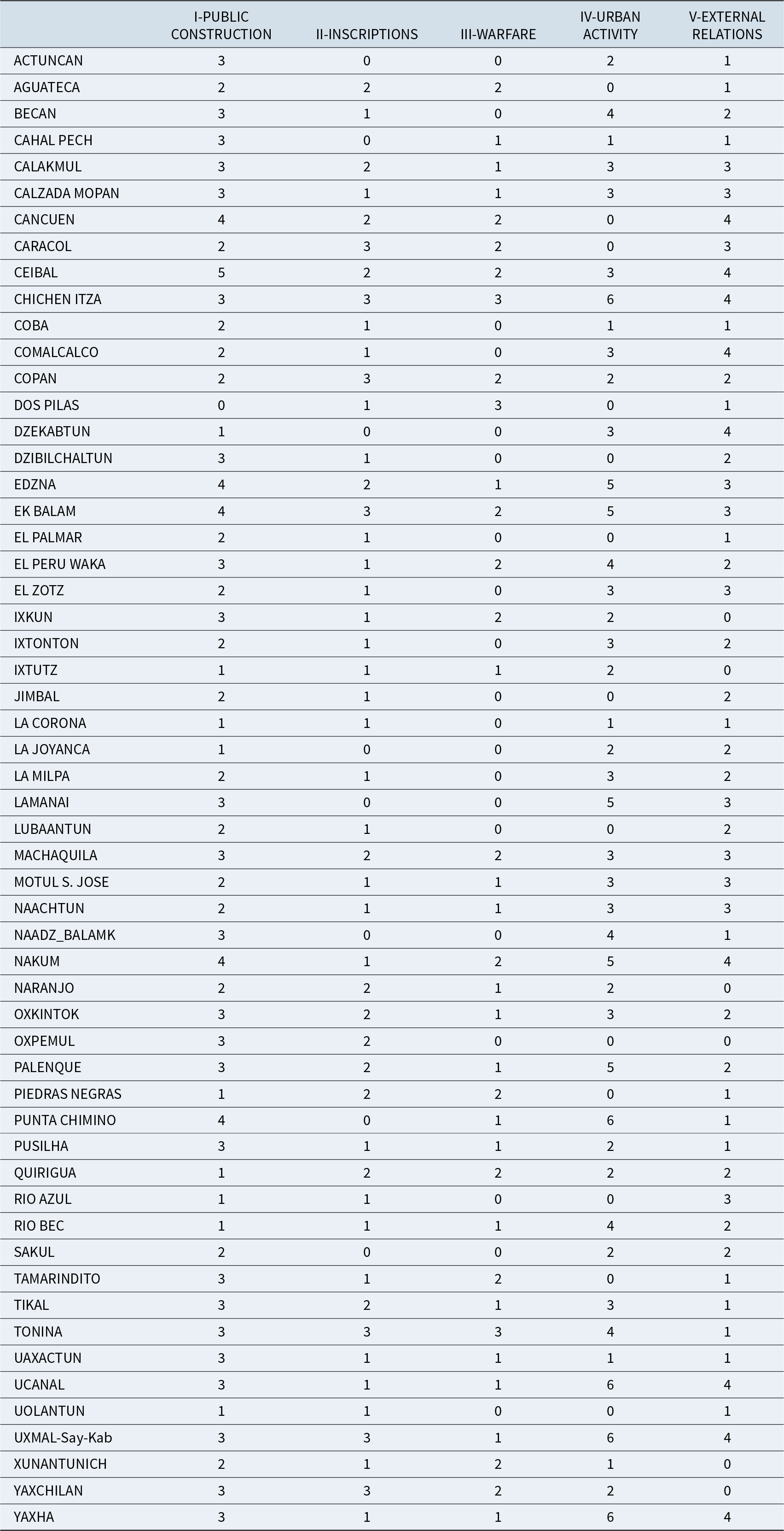
Table 3 presents the spreadsheet for the principal component analysis (PCA) and hierarchical cluster analysis (HCA), which is based on the cumulative counts of attributes per variable (Supplementary Material 4). Following the database conception, cities are described by qualitative attributes that are given as scores that are summed in categories, thereby transforming them into continuous variables. They were compiled and measured to detect correlations and oppositions among variables, and second, to identify similarities and dissimilarities among cases (cities). One preliminary statistical approach to exploring city variables is using Pearson’s correlation matrix, which summarizes the correlations between pairs of cities implying a scenario of linear and parametric relationships between them. This is a common first step in archaeological approaches to examining variables (Palmisano et al. Reference Palmisano, Bevan and Shennan2017). This hypothesis is logical given that all the sampled cities are comparable within these variables. If some cities share the same patterns, their resemblance through the attributes scores should be linear.
Scores of the Five Variables Representing 12 Attributes Distributed across 56 Sampled City Cases.

Note: See Supplementary Material 4 for attribute scores forming each variable.
The resultant Figure 1 illustrates the Pearson’s correlation coefficient, ranging from –1 (strong negative correlation) to +1 (strong positive correlation), for each city. In this figure, all correlations with a p-value ≤ 0.01, as determined by Pearson’s correlation test, were eliminated to ensure the retention of only the most significant ones. Two main groups are defined, one large group with positive correlations and one smaller group with negative correlations. Other cities present weaker coefficients but strong significance, implying their potential importance within the study group.
Pearson correlation matrix between cities (Projet Transition et Prédiction, Rémi Mereuze). (Color online)

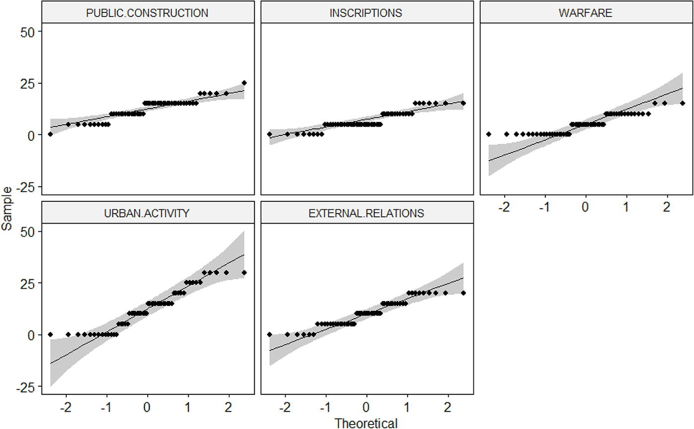
To investigate further, we examined the distributions, their normality, and their comparability for the five variables using a normal model known as the ANOVA (analysis of variance) test. A rapid graphical visualization provides substantial confidence that distributions are normally distributed within each variable (Figure 2). The ANOVA yielded a p-value of 1.51e–11, which is significantly less than 0.05, indicating that our test is statistically significant.
ANOVA, normality of variables distributions (Projet Transition et Prédiction, Rémi Mereuze).

The next step is to investigate how the parameters are associated to each other, which parameters influence the groups, and how the groups behave. PCA is primarily a visual method of exploring relationships between cases and variables (Husson and Josse Reference Husson, Josse, Blasius and Greenacre2014). This approach is preferred when considering more than two variables, five in our case. We performed PCA using R and the FactoMineR package (Lê et al. Reference Lê, Josse and Husson2008). Then, a HCA was performed following Ward’s method and the PCA coordinates. This is a more robust method than one based on correlation results (Husson et al. Reference Husson, Lê and Pagès2011).
Results
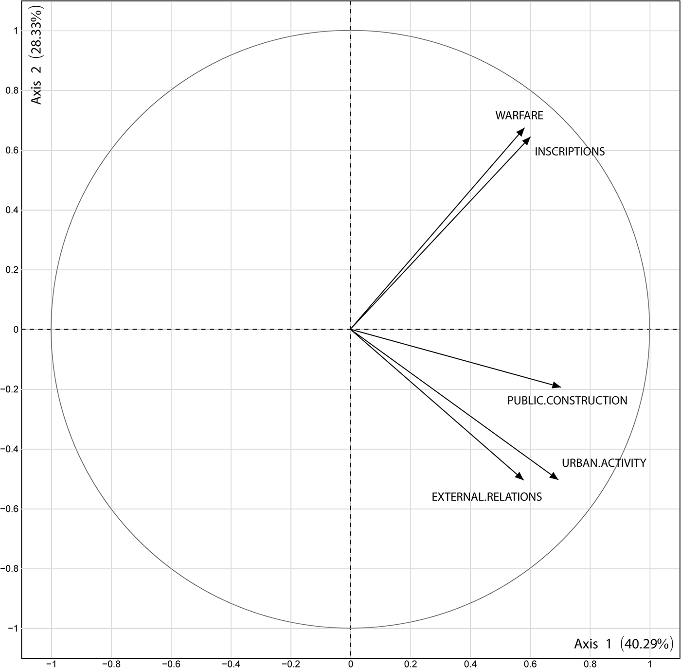
PCA and HCA treatments produce two main results. First, the five variables scatter close to the correlation circle (Figure 3), indicating a robust representation of these parameters. Warfare and inscriptions appear to be correlated, forming the expected canonical pair. However, urban activities and external relations are the innovating pair. These two pairs are widely separated at an almost right angle and are uncorrelated; that is, they behave similarly throughout the study set but do not impact or influence each other. This will be discussed in the following section. The second result is that the 56 cases or cities can be split into four clusters based on the HCA (on PCA coordinates at a distance level of 0.4; Figures 4 and 5).
Principal component analysis results for the five variables (Projet Transition et Prédiction, Rémi Mereuze).

Hierarchical clustering on principal component analysis coordinates (Projet Transition et Prédiction, Rémi Mereuze).

Principal component analysis graphical expression of results for the 56 cities (Projet Transition et Prédiction, Rémi Mereuze).

Inscriptions and warfare are correlated, but the public construction variable is not associated with them. Instead, located slightly farther away from the correlation circle, it is associated with the urban activity and external relations variables. Public construction includes canonical aspects such as royal tombs, hieroglyphic stairways, and a few TC royal palaces and temple-pyramids, involving slightly modified, or renewed architecture (e.g., at Ceibal; Bazy and Inomata Reference Bazy and Inomata2017; at Ucanal; Halperin and Garrido Reference Halperin and Garrido2020; at Nakum; Zralka Reference Źrałka2008; at Uxmal and Chichen Itza; Stanton et al. Reference Stanton, Taube, Coltman and Camacho2023). Yet primarily it is a strong indicator of collective activity: the clear correlation between public construction and TC urban activity suggests a thriving urban life in many places.
The second result is that the HCA dendrogram (Figure 4) and the PCA scatterplot (Figure 5) together produce four clusters, or groups of cities. Two groups (upper-3 and left-1) are defined by the warfare-inscription pair, while one group (right-4) on the opposite side of the graph is defined by all five variables. The last group (lower-2) is determined by the urban-economic pair of variables. Except between groups 3 and 4, there are no clear gaps between clusters, which is likely due to the repetitive and innovative aspects entangled in some attributes. It should be noted, however, that the HCA clustering is straightforward and simple (Figure 4). There are gaps within clusters 1, 3, and 4, indicating a degree of heterogeneity, and trends toward neighboring clusters that may be informative. We comment on Groups 3, 4, 2, and then 1. To help in the description of those groups, Table 4 presents their averaged scores.
Scores of the Five PCA Variables Averaged per HCA Groups of Cities.

Group 3 comprises 8 cities, with numerous inscriptions, that were impacted by well-documented endemic wars and early dynastic collapses (Dos Pilas, Piedras Negras, Aguateca, Yaxchilan, Caracol, Copan, Tonina, and Quirigua). We call this group the “warring cities.” Their urban-economic activity scores are low, and only Tonina has an Early Postclassic occupation. These cities are known to have ceased activity early in the TC period, characterized by rupture and rejection rather than repetition with innovation.
To the opposite side, Group 4 (comprising 15 cities, including Tikal) consists almost exclusively of capitals and large cities with high scores in all variables—partly due to city size and the extent of excavations. These cities are defined by their urban growth and economic functions as much as their political power, as reflected by numerous inscriptions and warfare. This is the only group also clearly defined by the public construction variable: Chichen Itza, Ek Balam, Ceibal, Uxmal with Kabah and Sayil, Nakum, Yaxha, and Ucanal. A subgroup located closer to the center of the graph includes Cancuen, Machaquila, Tikal, Oxkintok, El Peru-Waka’, Calakmul, and Palenque. All these cities, except Cancuen, maintained a resident population into the Postclassic, and political relevance at least into the late ninth century. Although all are marked by investments in maintaining political continuity with the Classic regime, the division into two subgroups relates to more intense construction and urban-economic activity in the right subgroup. This subgroup includes the new political supraregional capitals, while the central subgroup includes the old capitals. Thus, the entire group can be called “the capitals.”
Group 2 includes 16 cities that are all characterized by active urban development, few inscriptions, limited evidence of warfare, and more private than public construction (Becan, Motul, El Zotz, Comalcalco, Naachtun, etc.). Several of these settlements were little more than large villages (Punta de Chimino, Dzekabtun, La Joyanca, Actuncan), while others were important cities that imported many exotic goods and played a geopolitical role (Becan, Calzada Mopan, Naachtun, Motul). Most have an Early Postclassic occupation. These cities achieved innovative sociopolitical configurations and can be called “the innovative cities.”
Finally, Group 1 (17 cases) is the most heterogeneous. An upper subgroup (Xunantunich, Naranjo, Tamarindo, and Ixkun) is plotted close to the group of warring cities, and a lower subgroup (Uolantun, El Palmar, La Corona, Coba, Lubaantun, Jimbal, Cahal Pech, Río Azul, and Dzibilchaltun) is plotted closer to the group of innovative cities. Four cities (Oxpemul, Ixtutz, Uaxactun, and Pusilha) appear plotted in an intermediate position. Indeed, the entire group appears “intermediate” between the warring cities and the innovative cities. Group 1 may partly result from statistical noise and boundary effects due to a lack of chronological resolution. Nevertheless, this “intermediate group” deserves further discussion, among other matters.
Discussion
The results of the multivariate analysis performed suggest that parameters of urban life, such as residential construction and occupation, are closely correlated with public construction, openness to external relations and exchanges, and longevity during the Early Postclassic occupation. It is not surprising that TC cities with more urban-economic activities, including even public construction, survived into the Postclassic period. More surprising at first glance is that these variables are not negatively correlated with those of royal and canonical activities, including warfare. In other words, canonical practices such as stone inscriptions and warfare, do not necessarily indicate fewer activities and external relations. Conversely, more urban-economic activity does not necessarily entail rejecting all canonical practices associated with the Classic regime, including public building forms, as mentioned previously. This can be understood in three ways. Firstly, PCA is a means of exploring structured datasets, rather than detecting causative correlations within them. Secondly, the absence of correlation is an outcome of the nonlinear and chaotic properties of urban TC collective agency, as discussed in the concept section. As previously mentioned, some cities began or maintained canonical activities late in the ninth century without necessarily interrupting their trajectory of change. Ceibal is an example of this, especially when the city was transformed for the AD 849 celebration of the new baktun (Inomata and Triadan Reference Inomata, Triadan, Arnauld and Breton2013), which opened a new era of repeated, yet innovative, kingship. Thirdly, the lack of internal chronology superimposes the two trends onto a single period, canceling out their diachronic relationship. For example, Cancuen experienced significant urban-economic activity prior to AD 800, when traditional rulers were still in power (Andrieu et al. Reference Andrieu, Rodas and Luin2014; Demarest et al. Reference Demarest, Andrieu, Torres, Forné, Barrientos and Wolf2014:210; Forné et al. Reference Forné, Andrieu, Demarest, López, Rivera and Gutierrez2014). Chichen Itza also experienced substantial activity after AD 870, with new-style rulers and institutions emerging only three generations after Cancuen disappeared in AD 800 (Stanton et al. Reference Stanton, Taube, Coltman and Camacho2023). Nevertheless, both cities are plotted in the same cluster due to the Cancuen’s remarkably precocious development.
Framed by these relations, the HCA clusters differentiate cities with a high volume of canonical activities and warfare from those showing a greater degree of urban activity, openness, and longevity. The clustering is not perfectly discrete due to the overall widespread occurrence of repeated canonical practices, which produce intricate assemblages of attributes in what appears to have been a generalized, complex process involving ruptures, repetitions, and innovations in community reproduction. Further work is needed to disentangle these dynamic aspects in the TC attributes (see chapters in Stanton et al. [Reference Stanton, Taube, Coltman and Camacho2023] and Halperin et al. [Reference Halperin, Carrera, Wolf and LeMoine2024]). Beyond this initial assessment of the database, however, the consistency and significance of the groups resulting from the interaction of the variables can be briefly discussed in terms of longevity, political primacy, political emergence, and spatial location.
Longevity in occupation has a clear contrasting effect in the graph (Figure 5): Dos Pilas, abandoned early by AD 761, is plotted at the top left, while Lamanai, which remained a significant town into the sixteenth century and beyond, is plotted at the bottom. This symmetry is repeated in the cases of Aguateca, abandoned by AD 810 and plotted in the top left, while Punta de Chimino, Yaxha, Ucanal, Ek Balam, and Chichen Itza, all persistent cities (some of them well into the sixteenth century), are plotted in the bottom right. This is one critical pattern produced by the PCA graph (case positions are relative, not absolute; see also Table 4 for three diachronic attributes).
Political primacy and large size have already been noted for “the capitals” (Group 4). Large villages (La Joyanca, Dzekabtun) are plotted on the opposite side (lower left) to Chichen Itza and Ek Balam, forming the second axis of the graph. “The innovative cities” (Group 2) comprise villages and secondary cities, some of which may have been subordinate to those in Group 4, or rather “part of a new decentralized order in Peten” (Halperin et al. Reference Halperin, Lopez, Salas and LeMoine2020:483).
Political emergence is an attribute indexed in the MACCTOR database, alongside hiatus in inscriptions, yet it is not used in the PCA. This term refers to historically subordinate settlements that adopted certain canonical practices only after the great dynasties disappeared by AD 810–820 (Grube Reference Grube, Okoshi, Chase, Nondédéo and Arnauld2021; Inomata Reference Inomata2021; Martin and Grube Reference Martin and Grube2008). Many of “the intermediate cities” in Group 1 were indeed politically emergent centers (Table 4; Figure 5): Oxpemul, La Corona, and El Palmar had been secondary centers under Calakmul; Uolantun, Jimbal, Río Azul, and Uaxactun under Tikal; Xunantunich under Naranjo; and Tamarindito under Dos Pilas. Several of these cities erected their earliest inscribed monuments precisely in AD 830, the opening date of the new baktun, which heralded the beginning of their newly established power. Also noteworthy, two discarded attributes, joint rituals and change in royal image, appear to be well represented in the same intermediate Group 1, as well as in the capitals of Group 4. Supplementary Material 5 arranges these attributes and all others excluded from the PCA by presence/absence across the four city clusters. All chronological information is included, such as the Early Postclassic occupation attribute. This distribution is discussed in Supplementary Material 3, showing that, to a certain extent, it visually defines the four city clusters.
Geographic location in the lowlands may indirectly refer to the (partly exogenous) factors that contributed to the success or failure of cities (Figure 6). The warring cities (Group 3) are mostly located in the western and southern peripheries, which were perhaps vulnerable to incursions by nonlowland Maya. New large capitals are located to the north and east (Belize) close to the new Mesoamerican sea trade route (Turner and Sabloff Reference Turner B. L. and Sabloff2012). Group 2 comprises 10 out of 16 innovative settlements scattered along a significant axis connecting Tabasco to the eastern Belize coast: Comalcalco, La Joyanca, Motul, El Zotz, Naachtun, Río Bec, Becan, Naazdcan-Balamku, La Milpa, and Lamanai. This west-east central transpeninsular corridor was certainly made up of several competing routes, connecting Central Mesoamerica (including Veracruz) to the Atlantic coast by crossing the Yucatán peninsula (Arnauld et al. Reference Arnauld, Eliès, Cuenot, Garay, Grube, Botzet, Markianos-Daniolos and Graf2026). The old Lamanai settlement (Graham Reference Graham2001), and the Late Postclassic capitals including El Tigre-Itzamkanak, Noj Peten-Tayasal, and Tipu, were eventually located here. The PCA singles out this subgroup, identifying a system of innovative settlements positioned along new routes that cross the peninsula avoiding the difficult to navigate, bellicose Usumacinta River, as well as the long coastal, sea navigation.
Geographic distribution of the four city groups defined (Projet Transition et Prédiction, Sylvie Eliès and Charlotte Arnauld).

In summary, patterns produced by the variance across 56 cities in 12 indicator scores forming five variables show consistency and significance in terms of longevity, hierarchy, and geographical location. A ninth-century TC trend toward urban and economic developments ensured regional and interregional openness, as well as a degree of Postclassic longevity to more pluralistic cities governed by new agents (as measured by their investments into residential construction). This phenomenon characterizes a small majority of some 31 cities that are clustered into the two statistically defined Group 2, “innovative cities,” and Group 4, “capitals.” These were transitioning away from Late Classic political formulae and hence are considered to have been “rebounding” (see Lyons and Turner [Reference Lyons and Turner II2025] on the rebound issue). Admittedly, some Group 4 old capitals were rather in full decline from their top position, yet some Group 1 settlements appear close to Group 2 innovative cities. This TC rebound, temporally intermediate between the political collapse and the Postclassic (almost) complete abandonment, suggests that the early political collapse cannot be seen in all cases as the direct cause of the urban collapse. From a more spatial perspective, given the recent transformative impact of recent lidar surveys on our understanding of regional Maya settlement patterns, the distribution of these rebounding cities contributes to define emerging regional systems.
Conclusion
Multivariate analyses of variables reflecting canonic political versus socioeconomic activities consistently organize a large sample of Maya Lowland TC cities (AD 760–1000) into classes that support meaningful and coherent interpretations concerning their longevity, changing political hierarchy, and geographic location vis-à-vis trade routes. If the TC period could be divided into subphases showing diachronic variation (perhaps AD 760 to 820 and 820 to 950/1000; see Grube Reference Grube, Okoshi, Chase, Nondédéo and Arnauld2021:48), the statistical similarities and differences among the variables and cases (cities) would indicate progressive differentiation over time of urban and economic development (including public construction) away from political-warring strategies associated with the dynastic regimes that collapsed by AD 810–820. Because almost all cities were, nonetheless, deserted from AD 1000 onward, the causes of this urban collapse should be distinguished from those of the earlier political collapse.
Perhaps as important as this ordering of cases, the variables and attributes, and their relations, have been assessed through selection, assemblage, and statistical treatment. If, as it seems, TC archaeological datasets have a real potential in reflecting late lowland urban trajectories and elucidating chains of causalities in a dual collapse, a more complete treatment of the MACCTOR database indicators is required. This entails not only bringing up more diachrony but also splitting (or cumulating) attributes according to their significance in terms of rupture, repetition, or capacity for innovation—for example, warfare should be reworked in relation to militarism and/or internal strife. This would result in a substantial enhancement of distributional analyses across cities.
Many settlements adopted innovative urban-economic strategies that departed away from the traditional dynastic divine kingship practices. Yet, it is also evident that many cities retained elements of the latter. Although the ninth century is considered postdynastic (after AD 810–820), it is marked by political characteristics indicative of continuities. Concurrently, a general trend was underway toward the creation of new institutions more affine to specific urban capacities, perhaps with a higher degree of factional strife. Studies of the urban Maya collapse must account for both ruptures and transitions through repetition and innovation. In the TC lowlands, a picture emerges of political and economic competition among capitals, towns, and even large villages, amid a rampant Mesoamericanization, with new exchange routes redistributing assets. Throughout this period, climatic risks took new turns as this mounting competition was likely rupturing old and new networks that could have circulated staples. Because it was deeper and longer than the previous one in the ninth century, the drought of the eleventh century (Kennett and Hodell Reference Kennett, Hodell and Weiss2017; Kennett et al. Reference Kennett, Breitenbach, Aquino, Asmerom, Awe, Baldini and Bartlein2012) seems to have largely truncated urban trajectories and prevented the regeneration of most Central-Southern Lowland settlements. This drought might have induced a severe demographic crisis involving changes in morbidity, fertility, and mortality rates (Scherer and Golden Reference Scherer, Golden and Iannone2014:224) for many lowland societies.Footnote 1
Acknowledgments
We are much in debt to Jennifer Saumur, Juliette Taieb, Josselin Tecquert (Université de Paris 1-Panthéon-Sorbonne), Jean-François Cuenot (CNRS), and Romane Peronnet who collaborated with Julien Hiquet on the database in its early and later phases: the database has been provisionally dubbed MACCTOR, “Maya Cities of the Terminal Classic Period as Actors in the Collapse.” We would have been unable to develop the entire research (Projet Transition et Prédiction) without the intellectual stimulation of the international RITMO network (Ritual Actions and Time: Creation, Destruction, Transformation in Past and Present Mesoamerica) coordinated by Valentina Vapnarsky (2019; Vapnarsky et al. Reference Vapnarsky, Michelet, Nondédéo and Monod- Becquelin2025). The network opened up interdisciplinary perspectives and enabled many exchanges in meetings. We are also grateful to Eva Lemonnier, Gregory Pereira, Juliette Testard, Vera Tiesler, and three anonymous reviewers for their comments on earlier drafts, to Matthew Looper for his invaluable assistance with the epigraphic data, to Bruno Desachy for his encouraging and efficient guidance, to Clarissa Cagnato and Denis Williamson for improving style and formulations, and to Chloé Andrieu for her many insights.
Funding Statement
As part of the RITMO network, the Transition et Prédiction project was funded by a 2015–2016 grant from Maison d’Archéologie et d’Ethnologie de Nanterre, Université de Paris-Nanterre.
Data Availability Statement
The digital database is stored on Nakala https://nakala.fr/10.34847/nkl.19a82450.
Competing Interests
The authors declare none.
Supplementary Material
The supplementary material for this article can be found at https://doi.org/10.1017/laq.2026.10180.
Supplementary Material 1. Note on two collapses, political then urban (text).
Supplementary Material 2. Note on the MACCTOR database (text).
Supplementary Material 3. Note on composition and scoring of the variables used in the multivariate analysis (text).
Supplementary Material 4. Cumulative scores of the five PCA variables formed from the 12 selected attributes distributed across the 56 cities (table).
Supplementary Material 5. Presence-absence of attributes discarded from the multivariate analysis, distributed across the four statistically defined groups of cities (table).
Supplementary Material 6. Data sources per site (56 cities sampled from the database) (table).
Supplementary Material 7. List of bibliographical references for Supplementary Material 6 (text).