INTRODUCTION
The harbour porpoise (Phocoena phocoena Linnaeus, 1758) is common in Welsh coastal waters (Evans & Wang, Reference Evans and Wang2002) and is often encountered close to islands and headlands with strong tidal currents. Its distribution is reported from surveys in Pembrokeshire and southern Cardigan Bay (Pierpoint, Reference Pierpoint2001; Baines et al., Reference Baines, Reichelt, Evans and Shepherd2002), and from many casual sightings (Evans et al., Reference Evans, Anderwald and Baines2003). Despite this, little information is available regarding harbour porpoise ecology locally, and fine-scale habitat use at specific sites. Pierpoint et al. (Reference Pierpoint, Baines, Earl, Harris and Tregenza2000) report diel and tidal patterns of echolocation activity at one site, and observations at four other sites in the UK also suggest that porpoise behaviour is commonly affected by the strength and direction of the prevailing tidal currents (Evans et al., Reference Evans, Fisher, Rees, Wainwright, Farrell and Mayo1993; Pierpoint et al., Reference Pierpoint, Earl and Baines1994; Evans & Borges, Reference Evans and Borges1995; de Boer & Simmonds, Reference de Boer and Simmonds2002; Calderan, Reference Calderan2003). Gaskin & Read (Reference Gaskin and Read1985) report that harbour porpoises tracked using radio-telemetry, followed regular patrolling patterns between coastal sites whose direction were governed by prevailing tidal currents.
In a review of diurnal rhythms in cetaceans, Klinowska (Reference Klinowska1986) reports that tidal effects on feeding and travelling have been observed for several other small odontocete species in near-shore habitats (e.g. Kleinenburg et al., Reference Kleinenburg, Yablokov, Bel'kovich and Tarasevich1964, for Delphinaterus leucas; Saayman, Reference Saayman, Winn and Olla1979, Sousa sp.; Würsig, Reference Würsig1982, Lagenorhynchus obscurus). In Wales, Gregory & Rowden (Reference Gregory and Rowden2001) report correlation between the coastal movements of bottlenose dolphin (Tursiops truncatus), foraging behaviour and the state of tide. In Scottish waters, Mendes et al. (Reference Mendes, Turrell, Lütkebohle and Thompson2002) describe bottlenose dolphin foraging in the vicinity of a tidal intrusion front within a narrow estuarine channel. The regular occurrence of dolphins at the front was believed to reflect an accumulation of prey and increased foraging efficiency.
Harbour porpoises have a varied diet, exploiting seasonally abundant prey from both pelagic and demersal habitats (Santos & Pierce, Reference Santos and Pierce2003). Small schooling fish including herring and sprat (Clupeidae), sandeel (Ammodytidae) and members of the cod family (Gadidae) are important in UK and Irish waters (Rae, Reference Rae1965, Reference Rae1973; Rogan & Berrow, 1995; Martin, Reference Martin1995).
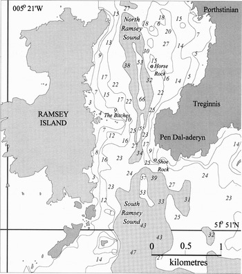
The aim of this study was to investigate the influence of the tide on fine-scale habitat use by harbour porpoises using data from Ramsey Sound, which is located at the extreme south-westerly tip of the coast of Wales (Figure 1). Ramsey Island lies less than 2 km off the Welsh mainland at approximately 52º 52′N 005º 20′W. It is 3 km long, on its north–south axis. The tidal stream is constricted in Ramsey Sound and currents exceed 6 kt on spring tides (United Kingdom Hydrographic Office, 1999), particularly in the vicinity of a reef of rocks known as the ‘Bitches and Whelps’ which extends east from the island shore. A tide race forms in North Ramsey Sound during the north-going flood tide and in South Ramsey Sound during the south-going ebb phase. A steep-sided trench of charted depth 66 m bisects Ramsey Sound longitudinally and several rocks and pinnacles create diverse seabed topography (Figure 1).
The bathymetry of Ramsey Sound, south-western Wales. Spot depths are shown in metres. Depths below the 30 m and 50 m depth contours are shaded.

MATERIALS AND METHODS
Data collection
Observations were carried out at three sites in Ramsey Sound: North Sound, Treginnis and South Sound, from August to December, 1992–1994. The Treginnis site comprised waters between North and South Ramsey Sound, in the vicinity of the Bitches reef and the Pen dal-Aderyn headland (Figure 1). In 1992 and 1993, observer effort was distributed approximately equally between periods of flood and ebb tide: there was 165 h (55%) observation in the first six hours after high-water, and 136 h (45%) seven to twelve hours after high-water. In 1994 there was a further 16 h observation that concentrated on fine-scale habitat use within South Sound during the ebb phase.
It was clear from preliminary observations that although harbour porpoises often occupied Ramsey Sound for periods of several hours, the total number of animals present fluctuated as individuals moved between the study area and adjacent waters. Study animals were not individually recognizable and it was difficult to track their movements for long periods. A standardized system of data collection (scan sampling) was therefore adopted that was sensitive to short-term changes in the number of animals present. Beginning at 5-min intervals, the study site was scanned slowly from north to south, using low-powered binoculars. Each observation period consisted of a minimum of twelve, 5 min scan samples. A total count of porpoises was recorded for each scan and the following data were recorded for each school: location, school size, number of calves, surfacing direction, surfacing speed, behaviour and associated seabirds. Animals within a radius of approximately ten body-lengths (~20 m) of each other and behaving similarly were considered a single school. Each school was observed for up to approximately five surfacings before data were recorded and the scan continued. No attempt was made to correct the data for animals out of sight below the surface, but care was taken to avoid repeated counts of the same school within each scan.
The location of each school was recorded in sectors delimited by bearings to prominent coastal landmarks. In South Sound during the ebb tide, positions relative to tidal features were also recorded. Three distinctive zones were used: (i) the central tidal race, characterized by fast (north–south) surface movement and sometimes standing waves; (ii) peripheral areas characterized by glassy upwelling ‘slicks’ and surface eddies; and (iii) areas outside the upwelling zone, east or west of the tide race.
Surfacing direction was recorded as compass points. If the school changed direction or individual animals surfaced in different directions, this was recorded as multi-directional surfacing. Surfacing speed was described as either: ‘slow’—a ‘lethargic’ type roll; ‘moderate’—a ‘typical’ harbour porpoise surface roll with back and upper flanks visible; or ‘fast’—much of the head and flanks exposed and some spray. Distinctive behaviours such as leaping, tail-slapping and remaining stationary at the surface were noted separately.
Environmental data including sea state, standing wave height (within tide race), cloud cover (oktas), glare (intensity and area affected), and tidal direction were recorded each 30 min or whenever changes occurred. Using Beaufort sea surface criteria, data were collected in sea state 2 or less.
Data analysis
The relative occurrence of harbour porpoises was described using the proportion of positive scan samples. The equality of proportions of positive scans at different states of tide was tested statistically (Miettinen & Nurminen, Reference Miettinen and Nurminen1985). Average counts of porpoise per scan were also compared across areas and tidal phases using a Kruskal–Wallis test and subsequent pairwise comparisons (Conover, Reference Conover1999). Association between porpoises calves and locations within and adjacent to the tide race, was tested using a χ2 (2 × 2) test.
The ebb flood tidal cycle in Ramsey Sound
Admiralty data indicate that the tidal stream in the vicinity of the study area begins to ebb south approximately 2.75 h after the predicted time of local high-water (HW) and that it reverses direction to flood north at HW +8.5 h. However, observations showed that the precise onset of periods of slack tide and the reversal of tidal direction often varied by up to 30 min from predicted times. Low-water slack tide (LWS) and high-water slack tide (HWS) did however, generally fall within 2–3 h and 8–9 h after HW respectively. Fine-scale current speed measurements were not available for Ramsey Sound. A substantial and abrupt difference in current speed between the main flow of water in South Sound during the ebb tide and adjacent upwelling zones was evident however, when transiting the study site in small boats, from the motion of fishing marker buoys, etc.
RESULTS
Comparison of sighting rates at three sites in Ramsey Sound
Porpoises occupied the South Sound more than the two other study sites. At South Sound, porpoises were present in 46% of scan samples during the ebb phase, and only 5% of samples in the flood phase. In the North Sound, porpoises were present in 4% of samples during the ebb tide and 8% of samples during the flood. Similarly, adjacent to the Treginnis headland, porpoises were recorded in 6% and 6% of scans during the ebb and flood respectively. Only in South Sound was the difference in the proportion of positive scans during flood and ebb significant (proportion difference = 0.41, approximately 95% confidence interval (CI) = 0.37 to 0.44, z = 14.4, two-sided P < 0.0001). Porpoises were recorded in 47 of 67 (70%) observation periods carried out in South Sound during the ebb phase.
The average number of porpoises recorded per scan was significantly higher at South Sound during the ebb tide than during the flood tide or at any state of tide in North Sound and Treginnis (T (adjusted for ties) = 396, P < 0.0001). The mean count in South Sound during the ebb was 1.55 (SD = 2.27, N = 1189 scans) and during the flood 0.18 animals (SD = 0.89, N = 377 scans).
Variation in sighting rates over the ebb–flood tidal cycle
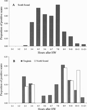
At South Sound, porpoise sighting rates remained relatively high throughout the ebb, but few sightings were made during the flood phase (Figure 2A). Porpoise schools were often first observed in the South Sound shortly after HW slack tide, as the tidal stream began to flow south. Animals would arrive either with the tide from the North Sound or move into the site from St Bride's Bay to the south. Porpoises would regularly occupy the South Sound for the entire ebb phase and LW slack tide.
The proportion of scan samples in which porpoises were recorded, relative to the time of last high-water (HW) in: (A) South Sound; and (B) Treginnis.

Although there was no significant difference between sighting rates at either Treginnis or North Sound during flood and ebb tides, there were clear peaks in activity close to the times at which HW and LW slack tides occurred, 2–3 h and 8–9 h after HW respectively (Figure 2B). Porpoises generally passed south from North Sound through Treginnis as the tide began to ebb. Similarly, as the ebb tide slackened, animals often returned to Treginnis from South Sound. Some porpoises remained in Treginnis during the first hour of the flood tide, but more usually passed directly into North Sound.
Habitat use
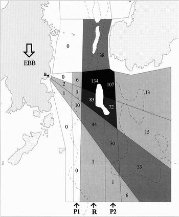
Within South Sound, porpoises surfaced most often either within the fast-flowing water of the central tidal race or within the upwelling zone on its eastern periphery (Figure 3). These areas corresponded to the deep water of the trench (50–60 m charted depth (CD)) and its steep sides respectively. Specifically, most sightings occurred at a point immediately downstream of a ‘saddle’ of shallower ground (25 m CD) that traversed the trench to the south-west of Shoe Rock.
The distribution of harbour porpoise sightings in Ramsey Sound during the ebb tidal phase. Shading is used to highlight relative levels of porpoise activity, and the number of porpoise schools recorded in each cell is shown. During the ebb phase the main body of fastest flowing water is located in cells above ‘R’. Peripheral areas ‘P1’ and ‘P2’ are characterized by slower moving water, upwellings and surface eddies. The observation position is marked at ‘a’.

Schools with calves showed a preference for peripheral upwelling areas, where current speeds were evidently low compared to the central race. There was a significant association for schools with accompanied calves and waters peripheral to the race, whereas schools without calves surfaced more frequently within the main body of fast-flowing water (Table 1: χ2 = 20.5, P < 0.0001).
Sightings of porpoise schools with calves and without accompanied calves, in the central tidal race and at its periphery. (O, observed numbers of porpoise schools; E, the number of schools expected if the overall proportion of schools that included calves (15.7%) was recorded both within the main tide race and on its periphery).

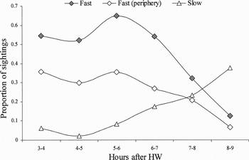
Porpoises surfaced more rapidly in the central ebb race than in peripheral areas. During the first four hours of the ebb tide, 52–65% of sightings in the main race were classed as ‘fast surfacing’. In peripheral areas 27–36% of sightings were classed as fast surfacing. In both areas the frequency of fast surfacing decreased towards the end of the ebb and into LWS (Figure 4). An opposite trend was evident for sightings classified as ‘slow surfacing’. Slow surfacing occurred more frequently than fast surfacing at LWS, both in the central race and on its periphery (38% ‘slow’ cf. 13% ‘fast’; and 73% ‘slow’ cf. 7% ‘fast’ in the central race and eastern periphery respectively).
Relative surfacing speed in: (A) South Sound; and (B) Treginnis. The relative frequency of fast and slow surfacing is expressed as a percentage of all sightings of porpoise schools.

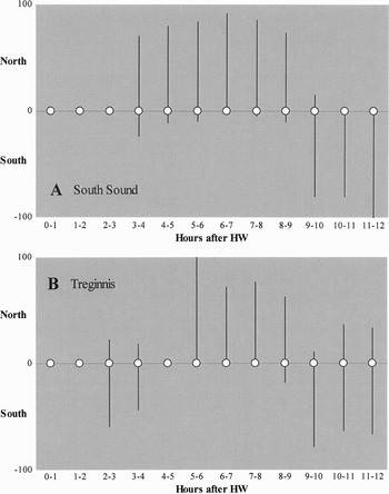
During the south-going ebb tide porpoise schools surfaced repeatedly against the prevailing current. Between 71 and 92% of sightings each hour were oriented north during this period and at LWS (Figure 5A). During the ebb phase, porpoises held station against the current in the main race. Towards the end of the ebb phase and during LWS, schools frequently moved progressively north, ultimately transiting from the South Sound to the North Sound. There were far fewer sightings in South Sound during the flood; however, the majority of these schools again surfaced against the direction of the prevailing tide.
Surfacing direction for porpoise schools relative to the time of last high-water (HW). The percentage of schools oriented north and south are shown as positive and negative deviations from the x-axis respectively. For clarity, the proportions of schools that surfaced in other or multiple directions have been omitted.

Observations at Treginnis documented the movements of animals through the site at transitional tidal periods. At HWS and as the tide began to ebb south most porpoises travelled south. At LWS most animals headed north. During periods of full ebb and flood relatively few sightings were recorded, but of these the majority were porpoises holding position against the direction of the prevailing tidal stream (Figure 5B), and not transiting through the site.
Observation of schools that surfaced repeatedly against the current, whilst maintaining position in the tide race was consistent with foraging behaviour. Rapid changes of direction and surfacing speed by single animals or coordinated groups suggested prey pursuit. Foraging groups were often followed by seabirds. Northern gannets (Morus bassanus) circled above porpoise schools and dived amongst them to take fish close to the surface. Gannets were associated with at least 20% of porpoise schools; bird associations were probably under-recorded, as the collection of these data was not prioritized when several porpoise schools were present. Gannets were less common in the region by the late autumn, but great black-backed gulls (Larus marinus) and herring gulls (L. argentatus) then regularly associated with porpoise schools. These species dropped to the sea surface close to porpoises, apparently to scavenge small fish or prey scraps.
In addition to foraging and transiting, a range of other behaviours were recorded. Porpoises were observed milling closely together in long series of short dives, particularly at times when tidal currents were slack. These observations suggested social interaction. Leaping was relatively unusual but also appeared to take place in a social context. Re-entry was either head-first, or side-on; leaps were usually single events and were recorded at a rate of approximately once each 120 sightings. Porpoises occasionally pivoted abruptly at the surface, throwing their flukes forwards through the air and splashing the surface (‘tail flip’). This was recorded on average once each 240 sightings. Single or multiple tail-slaps also occurred infrequently (once each 300 sightings). Resting stationary at the surface, sometimes drifting with the current was recorded at a similar rate.
School size and aggregation of schools
Schools of 1, 2 and 3 porpoises made up the majority of sightings: 37%, 32% and 16% of sightings respectively. Distinct units of six or more porpoises were not uncommon however, and comprised 6% of sightings. Mean school size overall was 2.3 (95% CI 2.2–2.5, N = 1204 schools). Often more than one school of porpoise was present and the average aggregated count at the study site was 3.4 animals (95% CI = 3.2–3.5, N = 833 scan samples). The largest aggregation was 20 porpoises.
DISCUSSION
Harbour porpoises were observed foraging in Ramsey Sound on the south-west coast of Wales. Foraging took place at specific phases of the ebb–flood tidal cycle and preferred habitat consisted of waters above and adjacent to a narrow, steep-sided trench in south Ramsey Sound. Habitat resources were limited in extent (the area of this site was a little over 1 km2) and apparently also temporally, as foraging was restricted almost entirely to the ebb tidal phase. Aggregations of up to 20 porpoises were recorded, although the mean number of animals present when the site was occupied was 3.4. Site use was high: over the course of this study porpoises were recorded in 70% of observation periods carried out in South Sound during the ebb phase.
Typically, harbour porpoises occupied South Ramsey Sound as the tide began to ebb (approximately two and a half hours after HW) and vacated the area following LW slack tide six hours later. As the ebb tide set southwards the tidal stream was constricted by coastal and benthic topography and a tide race formed above the trench. Porpoises surfaced repeatedly against the tidal stream, maintaining their approximate position relative to the seabed for prolonged periods. The observations suggested that porpoises adopted a foraging strategy of intercepting or ‘ambushing’ prey carried to them on the tide and concentrated by coastal and benthic topography. Alternatively, the porpoises' prey may have included predatory fish that also intercepted prey accumulated by the tidal stream.
Within the tide race, where current speeds could exceed 6 kt, most porpoise sightings corresponded to an area immediately downstream of a narrow ‘saddle’ of shallower seabed that spanned the trench south-west of Shoe Rock. Water depth rose from 55 m adjacent to the Pen dal-Aderyn headland to approximately 25 m at the saddle, before falling again to 57 m on its south side. A preference for these fast-flowing, constricted waters was presumed to reflect a high expectancy of foraging success. Although feeding could not be observed directly, porpoise schools were regularly followed by seabirds that either dived to take fish immediately ahead of porpoises rising to the surface, or scavenged prey scraps adjacent to surfacing animals. Similar observations are reported for tide race habitat on the east coast of Shetland (Evans et al., Reference Evans, Fisher, Rees, Wainwright, Farrell and Mayo1993; Evans & Borges, Reference Evans and Borges1995).
In Ramsey Sound, female porpoises with dependant calves preferred peripheral areas characterized by weaker currents, surface eddies and upwelling water displaced from the sides of the trench below. Females may have avoided areas where tidal currents were strongest because of a risk of separation from calves that might experience difficulty swimming against the tidal stream. The speed at which porpoises surfaced was lower in the peripheral zone than the central tide race, demonstrating the higher energetic cost of remaining within the area of highest occupancy. Surfacing speed in both the central race and peripheral waters decreased as the tidal currents slackened towards the end of the ebb phase.
Within the central tide race, there was a gradient of habitat usage down-tide of the primary foraging location. To the south, the tidal stream was less constricted by seabed topography and apparent current speeds were lower. Lower levels of porpoise activity here perhaps reflected a lower density of prey and potential for prey capture than within the preferred areas. In addition, porpoises occupying up-tide habitat were likely to encounter prey items before animals located further south.
In following a strategy of intercepting prey within the tide race, the likelihood of success was likely to vary as a function of time spent foraging. The total energetic cost of swimming against the prevailing tidal current however, must have increased concurrently. Individual animals therefore, faced cost–benefit type decisions regarding time spent foraging at this location and net energetic value of prey capture. The ability of porpoises to occupy the preferred habitat for extended periods and to forage successfully may have reflected individual fitness.
Primarily, harbour porpoises foraged at this site in groups of one to three animals. In some circumstances however, porpoises may have benefited from foraging in larger groups. Observations of groups of up to eight porpoises surfacing simultaneously and repeatedly in a closely-spaced line abreast were not uncommon during this study and suggested that animals sometimes formed temporary groups when intercepting or herding prey. Such groups displayed rapid, coordinated changes in direction and appeared to pursue prey swimming close to the surface. It was unclear however, whether individuals had acted cooperatively or merely converged on prey. Cooperative foraging has only rarely been reported for the harbour porpoise (Evans, Reference Evans1997; P. Evans, Sea Watch Foundation, personal communication). Factors leading to the formation of temporary associations therefore deserve further investigation.
Effects of topography and tide combine in Ramsey Sound to provide a foraging resource that occurs at regular and predictable intervals governed by a tidal rhythm. Gaskin & Read (Reference Gaskin and Read1985) report that the movements of porpoises tracked using radio-telemetry in the Bay of Fundy followed tracks determined by tidal currents, and similar observations have been reported for the coastal waters of Shetland (Evans et al., Reference Evans, Fisher, Rees, Wainwright, Farrell and Mayo1993). In Ramsey Sound, observations show that porpoise schools regularly arrive and depart from the foraging area by travelling with the prevailing tide. This inevitably reduced the energetic cost incurred while searching for prey. Porpoises possibly exploited a series of similar foraging sites in the region, using the tide to aid their passage between them—during the flood phase, foraging has been regularly observed at St David's Head 4.5 km north of Ramsey Sound (personal observation), for example, and in Jack Sound 14.5 km south–south-east (J. Poole, Wildlife Trust West Wales, in correspondence).
Activity other than foraging was also recorded in Ramsey Sound. Slow milling and intermingling of school members suggested social interaction. Leaps and tail-slapping also appeared to occur in a social context. Such activity occurred most frequently after extended periods of foraging in South Sound, as tidal currents slackened. Aggregation at sites with predictable foraging resources may have thereby provided opportunities for social interaction. Such opportunities may be important in a species with a short reproductive period (Read, Reference Read1990; Lockyer, Reference Lockyer1995) and a putative, promiscuous mating system (Read & Holn, Reference Read and Holn1995), but which is most often encountered singly or in small groups.
In conclusion, topography and tides combine at Ramsey Sound to create habitat used regularly by harbour porpoises. Foraging follows a tidal, semi-diurnal, rhythm and porpoises appear to adopt a strategy of intercepting prey carried through the narrow channel by tidal currents. The data raise issues concerning harbour porpoise energetics and strategies for foraging in high-energy habitats. An understanding of strategic choice in foraging harbour porpoises would benefit from data on fine-scale current speed and spatio-temporal variation in prey density within tide race habitat.
ACKNOWLEDGEMENTS
I thank Sue Ward and Ian Bullock for their hospitality, kindness and support on Ramsey Island. This study was carried out while the author was stationed on Ramsey under contract to the Wildlife Trust West Wales. I thank Caroline Weir and two anonymous referees for comments on an earlier draft.